24.75 MW Mouneswar + 24.75 MW Basavanna ‘Small’ Hydel Projects = One large HEP
According to the Ministry of New and Renewable Energy (MNRE), hydel projects between 2-25 MW are classified as Small Hydel Projects (SHPs). These projects are exempt from Environmental Clearance, impact assessment, public consultation or any monitoring from the Ministry of Environment and Forests (MoEF), receive subsidies from the MNRE and apply for Carbon Credits from United Nations Framework Convention on Climate Change (UNFCCC).
Though the concept of encouraging small hydel projects as sources of decentralized energy, also supplying off grid power seem welcome, the happenings on ground are vastly different. As these projects are excluded from environmental governance, there are several examples of fraudulent Small Hydro projects, which exploit the lax governance mechanism to hoodwink all concerned.[i]
One such recurring fraud is showing two separate projects on paper, in order to avoid environmental scrutiny and avail subsidies meant for SHPs, while building one single big dam on site, clubbing the two projects. Projects like Perla and Shemburi by Greenco in Mangalore or Maruthi Gen projects in Sakaleshpur (http://www.dnaindia.com/bangalore/report-maruti-power-gen-s-hydel-project-an-environmental-disaster-1617237), all in Karnataka Western Ghats, are two example of this fraud.
One more case has now come to light, this one from Gulberga district in north Karnataka when I visited the project area recently. Although called by two different names, 24.75 MW Mouneswar Small Hydel Project and 24.75 MW Basavanna Hydro Project are operating from a single dam/diversion weir across the KrishnaRiver, just downstream Narayanpur Dam. As such, the project should be considered as a single 49.50 MW hydel project and should undergo immediate environmental, social and legal scrutiny and further assessment. We tried to conatct the officials of the company several times for questions related to the projects, but we got no response.
The Projects:
24.75 MW Mouneswar and 24.75 MW Basavanna SHEPs are built across river Krishna in Benchagaddi village of Shorpur taluk of Gulberga district in Karnataka.
The projects have also applied for Carbon credits under the United National Framework Convention on Climate Change (UNFCCC). Basavanna Hydro Project has been registered as a Clean Development Mechanasim (CDM) project with the UNFCCC on 28th December 2012 and its crediting period has been fixed as 1st March 2013 to 28th February 2023[ii]. 24.75 MW Mouneswar SHP has applied for registration[iii]. SANDRP has sent comments against registration of this project.[iv]
Shockingly, both projects have requested separate registrations, hiding the fact that both will be using the same dam, the same intake/power canal and the same tail race canal.
Project design documents (PDDs) submitted to United Nations Framework Convention on Climate Change Executive Board (UNFCCC – EB) mention the same coordinates as the project location:
Latitude- 16°19’52 “N
Longitude- 76°33’48” E
Figure 1. Mouneswara and Basavanna diversion weir_ Google Earth
PDDs of both the projects do not even mention the other project, clearly misleading the UNFCCC. Not only do the PDDs show same coordinates, the lengths of the intake canals are exactly the same at 2771 meters, so are the RCC conduits and penstocks, because we are talking of the same project!
Carbon Credits are supposed to be provided to projects only when they prove beyond doubt that they will be economically unfeasible without such support. However, in this case the expenses of dam, power canal, and tail race tunnel is shared and hence the costs will be lowered, the Internal Rate of Return (IRR) of the projects will be higher than what is quoted in the PDDs and they will be profitable even without additional ‘pocketable’ finance from the UNFCCC in the name of Clean Development! (IRR claimed in the PDD is 9.14% for Mouneswar SHP and 11.38% for Basvanna SHP.)
Figure 2. Common Dam/Diversion weir for Mouneswara and Basavanna HEPs. Photo- SANDRP
Same Proponent, different names
Interestingly, project proponents of both the projects are shown to be different in respective PDDs. For Mouneswar Small Hydel Project it is Lakshmi Jalavidyut Limited and that for Basavanna Hydro Project it is Krishna Hydro Energy Limited. However, the registered office of both these firms is the same! This address also belongs to Penna Cements, Hyderabad, which is a player in Mini hydel projects in Karantaka. Penna Cements and its subsidiary Pioneer Genco already operate two SHPs, each of 24.75 MW capacity across Cauvery in Karnataka.
From the ground
When SANDRP visited the project sites, the officials were hostile to any entry in the premises or even near the site.
Figure 3. Dam/Diversion weir . Photo- SANDRP
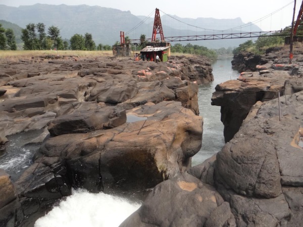
The dam/ diversion weir built by the projects is inside the KrishnaRiver bed and diverts the water through a power canal which runs approximately 3 kms downstream. The power canal takes most of the water from the river rendering the river dry in lean season.
Farmers told power canal as irrigation canal:
When I talked with the farmers in the downstream, they told me that they were under the impression that this canal is meant for irrigation, like Narayanpur Dam canals in the upstream (about 26 km). However, Benchagaddi village which is situated next to the tail race canal of the project not allowed to take even its drinking water from the canal.
There have been strong protests from the villages to this project as the diversion has dried the river bed and more than 300 irrigation pumps of villages like Bechagaddi, Hosur and Yedalabhavi used for irrigating paddy are now useless. Karanataka Bhagya Jal Nigam had also taken serious exception to the projects and had ordered a stop work notice.[v] (It subsequently issued an NOC, without providing any resolution to the issues raised by it earlier.)
The Benchagaddi village which is right next to the power canal experiences power cuts lasting 18-20 hours daily. Around 40 farmers from this village lost their lands for the canal. Rates of compensation given were Rs 25-85 thousand per acre.
Shockingly fraudulent Local Stakeholder Consultations!
The projects have claimed to have organised ‘Local Stakeholder Consultations’ about the CDM mechanism, which is mandatory when applying for CDM credits. PDD claims that Mouneswar project organised stakeholder consultations on 21st December 2011 and Basavanna project organized it on 26th September 2011.
Now see this, both PDDs mentions exactly the same people asking exactly the same questions with exactly the same answers being given!! It is absolutely clear that these meetings and these reports are fake. Amazingly, UNFCCC could not see through this clear fraud.
Local Development through Small Hydels?
As per the villagers, affected families were promised a job in the power plant although none of them received any jobs there. Even the JCB and truck operators are from other states. Security guards too aren’t from the same village.
Figure 4. Submergence area in the upstream of the weirFigure 5. Tail race canal near Benchigaddi village and the construction work of power house (Source: Google Earth)
Unaddressed impacts of Submergence:
In Geddamari village near the diversion weir, around 15-20 families lost their lands for construction of the dam. Bill collector (Talathi) of the village told SANDRP that around 50 acres of land was SUBMERGED due to dam (diversion weir) construction. He further added that farmers whose lands were submerged, have not received the compensation as yet. They have been talking with the company and have been verbally promised some compensation, though nothing on paper. Problems in this village too are like Benchagaddi village. Limited drinking water, disturbed power supply etc.
Figure 6. Power houses near Benchagaddi village. Photo- SANDRP
Applicable for Environmental Clearance:
As the projects use a single dam and are a single project of 49.50 MW and they qualify for a full environmental clearance process, including an EIA, public hearing, and Environmental appraisal by the state or central EAC and an Environmental Management Plan. However, the projects have illegally escaped all this.
Executive Engineer of Krishna Bhagya Jal Nigam (KBJN) – controlling state authority in case of Krishna River- confirmed, “Both the projects are operating using the same weir .The power houses of two projects are housed behind the same diversion weir. There are three 8.25 MW turbines for each of the projects situated downstream of the same diversion weir.”
According to the Executive Engineer, KBJN has granted NOCs to both the projects and that both of them being fully operational for last 6-8 months. When SANDRP visited the project site, the HEPs were found to be fully operational.
Conclusion:
24.75 MW Mouneswara and 24.75 Basvanna Projects are operating from the same diversion weir, use the same intake canal and same tail race. They are in fact one single project which has fraudulently shown itself as two separate projects. The proponent and the consultants have hidden this fact from the UNFCCC, the MoEF, the MNRE, KREDL, State Pollution Control Board and State Environmental Department. The Local Stakeholder Reports of the projects are a sham. Submergence impacts are still unaddressed.
These issues need to be addressed urgently by all concerned including the MoEF, the Karnataka Government, UNFCCC, MNRE and KREDL. Such frauds are giving a bad name to the all these institutes.
-Damodar Pujari (damodar.sandrp@gmail.com) with inputs from Parineeta Dandekar
Deteriorating health over the decades of river Yamuna in Delhi is a perfect example of an abject governance failure. All grandiose plans to restore the river to its past glory have been in vain. Yamuna Action Plans (YAP) implemented since 1993 with a consolidated spent of around Rs 1500 crores have succeeded (sic) in only taking the river closer to its demise in the city-state.
Guest Post by Dr. Latha Anantha, River Research Centre, Kerala
Possibly for the first time in the history of Kerala, a hartal led by the unlikely combination of a powerful section of the Church and the Left Democratic Front has rejected both the Western Ghats Panel Report (WGEEP) and the High Level Working Group Report (HLWG) claiming it as anti farmer. On November 18, 2013, the LDF and its supporters called for a state wide bandh which brought normal life to a standstill. Thousands of protestors took to streets, mainly from Idukki and Wayanad Districts. Events that are unfolding in Kerala hold significance for the entire country. Firstly it reveals the extent to which forces are trying to decide the fate of a common natural heritage like the Western Ghats through short sighted political means. Secondly it reveals the lack of democratic process by which the people of a region as diverse and ecologically significant as the Western Ghats are not taken into confidence by the Governments while introducing a new governance process. Thirdly the Western Ghats and the two reports on it has become the oven hot political weapon in an election year for Kerala.
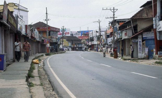
Closed shops in Wayanad during the strike. Photo: Deccan Chronicle
Violent responses
The incidents of violence and destruction of public property started off with the issuance of directions by the MoEF on the 13th November 2013 under Section 5 of the Environmental Protection Act 1986. Kannur and Kozhikode districts witnessed widespread violence on the 15th November. Forest offices, government vehicles and public transport buses were set fire by the angry mob in several places in North Kerala[1]. The High Range Protection Council led by the Roman Catholic Church organised a 48-hour road blockade under the banner ‘occupy the streets’ at Kattapana the district headquarters in Idukki district on the 18th ad 19th of November. In fact the Wayanad MP Sri M. I Shanawas called on Mrs Sonia Gandhi in New Delhi along with Bishop Remigius Inchananiyel of Tharamassary Diocese, patron of the resistance group spearheading the campaign in north Kerala, to convey the anxieties of the people.[2] Not a day has passed since 14th November, 2013 when the discussions over the two reports have not taken over the prime time news hour in the television channels of Kerala. The debate continues.
Why the hue and cry?
The MoEF directions and the subsequent Office Memorandum (OM) dated 16th November both reiterate that the MoEF has accepted the High Level Working Group report on Western Ghats, headed by Dr. Kasturirangan ‘in principle’. It also explicitly means that the MoEF has rejected the Western Ghats Expert Ecology Panel Report under the chairpersonship of Prof. Madhav Gadgil, though the OM makes absolutely no mention of the WGEEP Report!
Plantations in Neliyampathy ESA Photo: Author
Atleast 123 villages in Kerala will fall within the ESA (natural landscape). The category of development activities banned in the ESAs are restricted to mining, quarrying and sand mining, thermal power plants, red category industries, building and construction projects of 20,000 sq.m and above.
The watered down HLWG report and the OM does not contain any clause which would force the farmers of Idukki and Wayanad districts out of their land as alleged by the agitators. Clearly farmers would not resort to hooliganism of the kind which was perpetuated in Kozhikode and Kannur. Presently, the sand mining and quarrying lobby hold the largest political clout in Kerala with many political leaders and legislators alleged to be having direct share and ownership over the large granite quarries operating in the heart of the Western Ghats districts. More and more farmers in the mountains are selling their land to quarry contractors. Now this is something which can become difficult if the restrictions are imposed. As somebody was remarking in a bus my friend was traveling in, ‘if mining stops, the JCBs will have to be sold at the price of scrap metal, that is the issue”!
Polluted stream in Valparai ESA Photo: Author
By this time a large section of population including the ruling party legislators in Kerala openly admit that the Kasturirangan panel report is a watered down version of the Gadgil panel report and is not going to bring in much changes in status quo conservation. Meanwhile, the clause (viii – d) on banning township and area development projects with an area of 50 ha and above and / or with a built up area of 1, 50 000 sq.m. shockingly reveals further dilution. The MoEF has gone against the ‘in principle’ acceptance by inserting this recommendation which was not included in both the reports! HLWG report has categorically stated that no more new townships and settlement areas will be allowed in the Western Ghats. This new insertion by the MoEF opens up the space for mining and quarrying in the name of township development within ESA areas diluting the concept and spirit of ESA. Meanwhile many ecologically sensitive areas have been left out of the HLWG report which will be opened up for mining and other development.
Baseless rumours are being spread over how the report will affect the high range population! Allegations are now reaching ridiculous levels include, ‘The hidden agenda is to convert all the ESAs into forest area in a stage by stage manner; tiger cubs are being introduced into the forest to evict the people; no more new houses will be allowed once the ESAs are declared; no more monoculture plantations in the Western Ghats; all houses in ESAs have to be painted green and lights have to be switched off by 8 pm; so on and so forth are the interpretations led by the church and the political fronts. The people living in the plains are being warned that they will have to bear the onslaught when lakhs of evicted farmers from the high ranges will settle in the plains! To top it all, the revenue department officials are warning people against land registration or land transfer citing that until further directions are given, no land transaction can be carried out in ESA villages!
There are misleading attempts to show that Ecologically Fragile Lands Act EFL Act (2005) and ESA are the same. The EFL Act is a state Act to provide for the vesting in the Government of ecologically fragile lands in the State of Kerala and for the management of such lands with a view to maintain ecological balance and conserving the bio-diversity. Ecologically fragile land denotes any forest land or any portion thereof held by any person and lying contiguous to or encircled by a reserved forest or a forest or any other forest land owned by the government and predominantly supporting natural vegetation. This Act allows the Government to vest such a land from the owner and make it part of the Reserve Forest. It also gives power to the government to evict any person occupying the notified land. The ESA meanwhile comes under the purview of the central Environment Protection Act 1986. It does not entail any eviction or vesting of land by the government or the Forest Department. There is no eviction of farmers entailed in either the WGEEP or the HLWG report. Any news about evictions is politically motivated and baseless.
The concerns and anxieties of the local communities who have made the mountains their home since three generations when a new regulation is being ushered in cannot be ruled out. The distressing state of the Western Ghats calls for stringent protection measures as well. ESA under the EPA (1986) is the best option available wherein conservation can be ensured without displacing people. Meanwhile the other states seem not too perturbed by the decision of the MoEF to accept the Kasturirangan Report. The high population density in Kerala Western Ghats plus the vested interests of the quarrying lobby and the church (which holds large tracts of land in the mountains) could be attributed as the reason for this uproar.
Reparative Measures
The Government of Kerala has meanwhile taken a guarded stance with respect to the Kasturirangan report instead of totally rejecting it. They have assured the people no decisions will be taken in haste. However, the GoK reacted late by stating that they will translate the notification when it is out and hold discussions in each of the ESA panchayaths. In response to the first OM issued on 19th October, 2013 (which was surprisingly cancelled by the MoEF and replaced by the OM on 16thNovember, 2013), the Kerala Government constituted a three member expert committee headed by the Kerala State Biodiversity Board (KSBB) Chairman to seek opinions from farmers’ organisations, environmentalists and people’s representatives from the regions that will be affected once the Kasturirangan report is implemented. The state also plans to circulate the HLWG report’s Malayalam version to all the 123 villages[3]. Round the clock help lines have been opened by the Kerala Forest Research Institute (KFRI) and KSBB to clarify the doubts of the public. Chief Minister Ommen Chandy has decided to convene an all party meeting to seek opinion from the various political units of the state. The Kerala Pradesh Congress Committee (KPCC) has also constituted a five member committee to seek opinions through district level hearings.
Lapses in democratic processes come with a cost. If the Government had taken the pains to interpret the WGEEP report way back in 2011 when it was published and undergo the above processes, so much politically created antagonism towards the WGEEP report, the destruction of public property and loss of 900 crores to the public exchequer by an uncalled for bandh could have been avoided[4]. The LDF too could have organized discussions and debates on the two reports instead of rejecting both the reports.
Consciousness for the Western Ghats is growing
What was the need to constitute the HLWG by the MoEF? New ideas and governance mechanism takes time to sink in the public mind and the development sectors that are used to work in silos. The MoEF bowed to the pressure from different lobbies and went ahead with the new panel without giving time to the state governments or the people to understand the WGEEP report. And not surprisingly the HLWG panel digressed from its ToR and came out with a status quo report. Hence the pro Athirappilly project lobby is happy with the HLWG report. While the WGEEP report had totally rejected the Athirappilly project, the HLWG has given space to the Government to revaluate the project and take it up with the MoEF if needed.
Is the Western Ghats Ecology Expert Report (WGEEP) sent for a burial? The MoEF seems to have done so. But many in Kerala where the maximum opposition to both the reports came in, think otherwise. The dots are growing into a network of like-minded groups and individuals who believe the Gadgil report should be accepted and not the HLWG. There is increasing realization that the WGEEP report has mooted a completely new system of governance based on ecological limits and carrying capacity of a region, democratic decentralization and a futuristic perspective of inter-generational equity. While recommending sanctions and regulations, the process is intrinsically democratic where discussions and decisions about the wise use of natural resources have to be made by the local communities. Not surprisingly even the media discussions start with the HLWG report and end up supporting the WGEEP report! There is still scope for the public to demand with the MoEF that the WGEEP report be implemented after correcting the grey areas. The rest of the Western Ghats states need to take cue from the happenings in Kerala and start a process of democratic discussion with the ESA village communities and different development sectors to avoid future problems that may crop up. The conflicts and riots have reinforced the conviction that it is time to start a peoples’ movement once again to save the Western Ghats!
It seems Rajasthan state is ignored and is silent as Madhya Pradesh is going ahead with massive water resources development projects in interstate ChambalRiver basin. Some of these projects were even part of the interstate projects discussed for several years between the two states and now Madhya Pradesh is going ahead with them unilaterally. Mohanpura and Kundaliya projects were also part of the ParbatiKalisindh ChambalRiver link, one of the priority links of Union Government, but now MP is going ahead with them without any consultation with Rajathan or Government. In response to SANDRP questions, Madhya Pradesh responded, as recorded in the minutes of 68th meeting of EAC held in Sept 2013, “It was clarified that the NWDA scheme has not been accepted by the M.P. Government and is not likely to be implemented in the near future. The M. P. Government wants immediate implementation of Mohanpura Project”.
Lift irrigation project in NCS. Source: SANDRP partners
Not only that, the MP has ten times increased the size of the projects, which will have huge, unassessed downstream impacts on people, river and environment. The interstate National Chambal Sanctuary (NCS) will also be seriously adversely affected, but the downstream Rajasthan seems neither consulted nor concerned.
Gharial resting on a sand bank with Indian Cormorants and Lesser Whistling-ducks in NCS Source: SANDRP partners
Below we have given some information about some of the projects that have come up for clearance before the Union Ministry of Environment and Forests’ Expert Appraisal Committee on River Valley Projects (the meeting number and date of meetings are given) over the last couple of years. All of these projects are in Chambal basin in Madhya Pradesh and are being taken up without consent of or consultation with state or people of Rajasthan.
Mohanpura Major Irrigation Project
Dist/ State
Rajgarh / Madhya Pradesh
River/ Basin
Newaj
Proposal
TOR
Developer
Water Resource Department, Bhopal, Govt of Madhya Pradesh
Height of Dam (m)
47.90
Drinking water supply
20 MCM
Industrial Water Supply
60 MCM
CCA (Ha)
65,000
Submergence area (Ha)
7051
Area required (Ha)
NA
Villages affected
36 (1800 families) (10,240 persons)
ForestLand
NO
Decision
52nd Meeting (16-17.09.2011)
Decided that some additional information may be submitted
53rd Meeting (11-12.11.2011)
No effective discussion on the parameters of the project could be made and it was decided that the project shall be discussed again along with the information submitted by the M.P. Govt.
54th Meeting (26-27.12.2011)
Recommended scoping clearance and TORs with the same comments and observations made for Kundaliya Project.
This Mohanpura project (for more information on this, see: https://sandrp.wordpress.com/2013/11/15/mohanpura-dam-in-madhya-pradesh/) have been under discussed in the EAC now for full environment clearance and does not include any reference to Rajasthan, interstate aspects, downstream impacts, or impact on Chambal River of National Chambal Sanctuary. Some details in this respect are given below.
Much bigger Mohanpura Reservoir proposed compared to the PKC proposal It is clear from the perusal of the Feasibility Report of the PKC link given on the NWDA website that the project now proposed by the Govt of Madhya Pradesh is much bigger and an unviable scheme. The Gross and live storage of the NWDA scheme is 140 MCM and 52.5 MCM, where as the proposal now has gross storage of 616.27 MCM and live storage of 539.42 MCM, which means the live storage proposed now is more than ten times the live storage proposed in NWDA scheme. In fact the NWDA scheme had the proposal to transfer 464 MCM from the Patanpur Dam to the Mohanpura dam and yet, under the Mohanpura live storage capacity proposed under NWDA scheme was much smaller.
Location map of the Mohanpura Project (Source: Project EIA)
Interstate aspects ignored The project is coming up on an interstate river basin and will have clear implications for the downstream state of Rajasthan, but there is no mention of this in the EIA. Several meetings have also happened between Madhya Pradesh and Rajasthan about the PKC link mentioned above. The Government of India has prioritized this link, but by taking up this project unilaterally without consent of Rajasthan or Centre (Ministry of Water Resources) the Madhya Pradesh government is violating the interstate and federal norms. The EIA does not even mention any of these issues.
Kundaliya Major Irrigation Project
Dist/ State
Rajgarh and Shajapur Districts/ Madhya Pradesh
River/ Basin
Kalisindh
Proposal
TOR
Developer
Water Resource Department, Bhopal, Govt of Madhya Pradesh
Height of Dam (m)
44.50
Drinking water supply
18 MCM
Industrial Water Supply
84MCM
Diversion
1037 cumecs of LakhundarRiver to river Kalisindh
Live storage capacity
495.20 MCM
CCA (Ha)
58040
Catchment Area (sq km)
4900
Submergence area (Ha)
7476
Villages affected
56 (8630 persons)
Forest land
680 ha
Decision
52nd Meeting (16-17.09.2011)
Desired some more info.
53rd Meeting (11-12.11.2011)
It was decided that the project shall be discussed again along with the information submitted by the M.P. Govt. The Committee felt that considerable area of forest land is to be submerged in the project (680 ha). The forest maps provided as a part of additional information lack clarity.
54th Meeting (26-27.12.2011)
Recommended scoping clearance and TORs with some suggestions/comments.
Kalisindh Major irrigation project
Dist/ State
Sajapur/ Madhya Pradesh
River/ Basin
Kalisindh
Proposal
TOR
Developer
Water Resources Department, Govt of Madhya Pradesh
CCA
49023
Submergence area (Ha)
4239
Area Req (Ha)
4919
Village affected
15 (2384 PAFs)
Decision
61st Meeting (12-13.10.2012)
Sought some additional information.
62nd Meeting (23-24.11.2012)
Recommended clearance for pre-construction activities and TOR with some additional TORs.
It is high time Rajasthan government and people wake up to this reality of upstream developments and write to Madhya Pradesh, Union Ministry of Environment and Forests and also Union Water Resources Ministry against these developments.
A small bus load of pilgrims descended at Walen Kondh and bought the usual Prasad from a shack by the river. They crossed a suspension bridge over a deep gorge of Kal Nadi and went to the derelict temple of Vardayini Mata on the other bank.
Kal River at Walen Kondh. Photo: Author
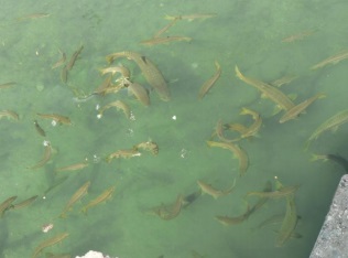
Then a few girls among them did something unusual. Instead of offering the Prasad at the temple, they came to the ridge of the gorge and clapped a few times, peering into the river below. In a matter of seconds, there was frantic thrashing in the waters as a huge school of endangered Mahseer fish congregated swiftly. The devotees then threw in fistfuls of puffed rice to hundreds of Mahseer below. For the devotees, these fish are sacred: the children of Varadayini Mata.
Temple of Varadayini Mata . Photo: Author
Walen Kondh in Mahad Taluka of Raigad District in the Western Ghats of Maharashtra is one of the several critical community fish sanctuaries of India that protect the Mahseer fish. These sanctuaries have been successful in conserving not only the fish, but also stretches of rivers through their unique actions which find no support from the establishment and limited recognition from the conservation community.
Devotees offering puffed rice to Mahseer below. Photo : Author
Deccan Mahseer (Tor Khudree) is classified as an endangered specie by IUCN[i]. It does not feature in the schedule of species protected under the Wildlife Protection Act (1972) which is not a surprise as the Act represents freshwater diversity very poorly. However, many researchers, fisher folk and anglers have recorded that Tor Khudree and associated Mahseer species (Tor tor, Tor putitora, etc) which were once plentiful in rivers across Western Ghats, peninsular and central India, HimalayanRivers as well as floodplains, has now reduced drastically.
One of the major reasons behind the collapse of fish species like Mahseer is dam construction. Mahseer species migrate in the upstream to smaller streams for spawning (breeding). They need a flood pulse to undertake this migration. While other factors like pollution, overfishing, etc. have contributed to the decline, the multiple impacts of dams in terms of blocking migration paths, reduction of water levels in the downstream, submergence of pools in the upstream, changes in natural hydrograph and flood pulses, changes in sedimentation, etc., have been the primary reasons behind this collapse. (SANDRP’s report on Impact of Dams on Fisheries: sandrp.in/dams/Impacts_of_Dams_on_Riverine_Fisheries_in_India_ParineetaDandekar_Sept2012.pdf)
Fall of Mahseer has affected the ecology, local livelihoods, angling and recreational fishing in the rivers. While Hoshangabad on the banks of Narmada recorded 5-6 tonnes of Mahseer landings every year, it has been nearly wiped out from these places now[ii]. Mahseer used to form the majority of catch in these parts and has been severely affected by reservoirs like Tawa, Bargi, Sardar Sarovar and other Naramada projects. However, hardly any efforts are being made to reverse this situation. According to Shashank Ogale, who set up and managed Mahseer hatcheries in Tata Dams for more than 20 years, there are next to none functional Mahseer hatcheries in the country. This is despite the fact that dam proponents show an expense of crores of rupees to set up hatcheries as a part of their Environment Management Plan. After granting clearances, which are also based on these EMPs, MoEF does not bother to monitor the functioning and efficiency of these hatcheries or the impacts of dams on fish diversity and fisheries[iii].
In such a scenario, community conserved fish sanctuaries which are scattered across the country are playing a very important role in conserving various species of Mahseer as well as stretches of rivers. Unfortunately, most of these sanctuaries get no protection by the State Governments, Forest Departments or the Ministry of Environment and Forests. This is at a time when freshwater diversity is declining at the fastest rate globally[iv]. Ministry of Environment and Forests has done precious little in conserving or protecting riverine diversity, fisheries or rivers from the onslaught of dams. These sanctuaries keep getting submerged, dried up or fragmented by newly planned dams and State Fisheries Departments don’t bat an eyelid before giving a no-objection certificate (NOC) to projects which will spell doom for these sanctuaries.
Renole Pujari from Walen Kondh tells me that they have received no support or protection from the government to conserve Walen Kondh Sanctuary, however the community sanctions are so strong that not only is fishing banned across 2 kilometers from this stretch, but people are not even allowed to get down to the water, near these fish. He only hopes that this stretch of Kal nadi[v] is not destroyed by dams and chemical pollution like the neighboring Savitri River which flows through the chemical MIDC at Mahad. Fish kills are a regular feature of Savitri River.[vi]
In Maharashtra, Tilase is one more such small village in Wada Taluka of Thane district which protects Mahseer fish in Vaitarna River. The stretch is downstream of Upper Vaitarna Dam which supplies water to Mumbai. Local youths told me that fish kills occur here when water releases from Upper Vaitarna decrease. Downstream this stretch, Middle Vaitarna Dam has now come up and the sanctuary is now sandwiched between the two projects. Social sanctions here are so strict that a net cannot be put in the waters, even to check the species. Fish Sanctuaries also existed in Alandi and at Pandharpur along teh Bhima, but have been wiped out. In Vidarbha, several Dev dohs (Sacred Pools) exist in Rivers like Adan, Kathani, Wainganga, etc., where fishing is banned.
Small community fish sanctuary on Vaitarna River Photo: Author
Accoridng to Rajendra Kerkar, Goa too has community conserved fish sanctuaries protecting the Mahseer at ‘Pistyachi Kon’ nesteled between Bhimgad and Mhadei Sanctuaries. It receives no protection.
In Orissa, along the Mahanadi on the banks of the leaning temple of Huma exists the Huma Mahseer Sanctuary. On the banks is a stone statue of a lady cutting a Mahseer fish. Legend goes that the one who fishes in this stretch will meet the same fate, like King Midas! Hirakud Dam has already affected this sanctuary and the proposed Lower Suktel Dam will make things worse.
Stone Statue at a fish sanctuary on the banks on Mahanadi in Orissa Photo: Wikimedia
Karnataka possible has the highest number of community fish sanctuaries in the Western Ghats. Nakur Gaya and Yenekkal fish sanctuaries exist on the banks of Kumardhara in Dakshin Kannada. In Yenekal, local gram panchayat has built a small weir with wooden gates for maintaining water levels for the fish. The weir is so small that the fish can migrate over it in the monsoons. Both these sanctuaries are threatened by the numerous mini hydel projects coming across the region, especially the 24.75 MW Kukke Mini Hydel Project near Hosmata[vii]. Fisheries Department however has given an NOC to this and many other mini hydels coming across the region without even attempting to study their impacts on Mahseer and other fish.
Congregation of Mahseer at Yenekkal Fish Sanctuary on Kumardhara River Photo: Author
200 MW Gundia Hydel project will also affect the entire hydrograph of Kumaradhara-Gundia rivers. Here. The EIA done by KPCL (Karnataka Power Corporation Limited) says that there are no rare and endangered fish in the area. 5 new fish have been discovered in the region just in the past one year!
Child feeding fish at Shringeri fish sanctuary, Tunga River Photo: Author
Karappura Fish Sanctuary in Mysore was submerged by the Kabini reservoir while the Shimoga Agrahara Sanctuary collapsed due to dwindling water levels which resulted after construction of Tunga Anicut 12 kilometers upstream from here.[viii]
Lovely Tunga River at Chippalgudde fish Sanctuary Photo: Author
Uttarakhand and Himachal Pradesh too have temple fish sanctuaries, notably the Baijanath Temple complex on the banks on River Gomti in Uttarakhand conserves Golden Mahseer (Tor putitora) and supports a small fish sanctuary on its banks. Many isolated fish sanctuaries are also reported from the Ramganaga and Kosi area near Corbett. However, it is also reported that now these sites are used by anglers and the temples receive revenue in return. In Jogindernagar, a town in Mandi distirct of Himachal Pradesh, lies a lake known as Machchiyal, fed by River Uhl. This lake is supposed to be the abode of Machendru Devta, the Fish God. Fish are fed and worshipped here regularly and fishing is strictly prohibited in the lake. Machchiyal supports a large population of the Himalayan Mahseer. There is a Temple of Machendru Devta on the lake bank with ancient idols of fish-god.
Congregation of Mahseer at Baijnath Temple Sancatury on Gomti RIver Photo: Malvika Chauhan
In the remote Tawang in Aruncahal Pradesh in the North East corner of India flows a beautiful river Nyamjangchu. Buddhist Monpas rever the river as well as the fish in Nyamjangchu. Fish in the Nyamjangchu are not hunted. The river is threatened by the proposed 780 MW Nyamjangchu Hydel project which will divert or submerge nearly the entire length of this river flowing through India. Even premier research institutes like CIFRI (Central Inland Fisheries Research Institute) have done a shoddy study and supported the project and have not raised the issue of impact of this dam on fish diversity.[ix]
On the occasion of World Fisheries Day 2013, we urge to the MoEF to document the existing sanctuaries and grant immediate protection to all the existing fish sanctuaries in the country, protecting them from the onslaught of dams and other pressures. We had sent a similar submission to the moEF which was endorsed by several Fisheries Scientists and activists across the country in 2012, we’ve received no response from the MoEF on it till date (https://sandrp.in/rivers/MoEF_EAC_Submission_Fisheries_Nov2012.pdf, sandrp.in/rivers/World_Fisheries_Day_PR_Nov2012.pdf).
These sanctuaries stand testimony to the fact that community conservation is one of the most sustainable and effective ways of protecting ecosystems. The sanctuaries and their keepers deserve respect and recognition.
It was certainly a Conference of Party (COP) of sorts. Those present included farmers, women, academics, media persons, delegates from other states (Gujarat, Madhya Pradesh, Uttar Pradesh, Delhi), Non Government Organisations and elected representatives. It also happens to be an annual event that has been going on for 27 years. It was certainly celebrating the work that actually helped mitigation and adaptation in changing climate in both drought and flood related possibilities. It was also happening on the same dates as the COP 19 was going on far away in Warsaw, Poland.
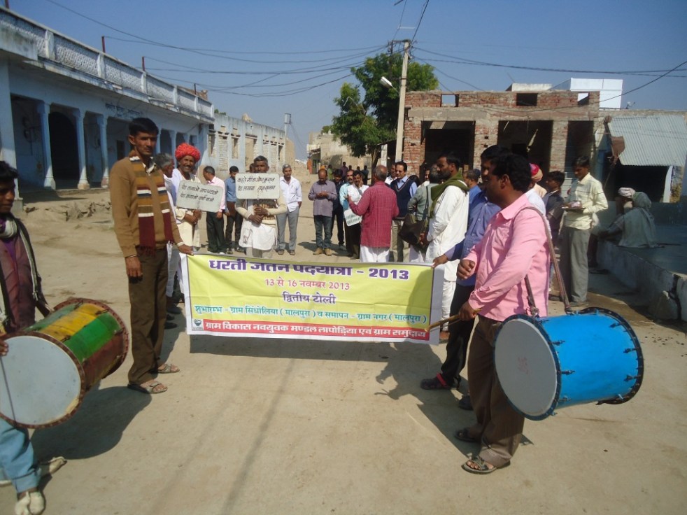
One of the two streams of Yatra arrives at Nagar
It was an honour for me to be present at Nagar village in Malpura block in Tonk district in Rajasthan at the 27th annual Dharati Jatan conference where the Pad Yatra from two different streams that culminated. Five eco warriors were honoured at this meeting with a certificate, silver medal, shawl and other ceremonial gifts. They were being honoured for their work related to tree plantation, soil and water conservation and protection of grazing land.
As speakers at the conference on November 16, 2013 narrated, this annual festival is a remarkable achievement by the Gram Vikas Nav Yuvak Mandal at Laporiya in Dudu block in Jaipur district, led by Laxman Singh, now famous for his grazing land protection through the unique chauka system.
The Yatra prepares for the worship of the Nagar village tank
Experience of the marchers The leaders of two streams of marchers presented their experience. Rameshbhai Saini, leader of the first stream that marched through the 15 villages of Dudu block (Jaipur district) also mentioned the difficulties people are facing. For example, he mentioned how Phulsagar, one of the tanks in Laporia is encroached and communities’ efforts to remove the encroachment did not succeed as the encroacher had the support of the Rajasthan minister Babulal Nagaur who is also the member of the Legislative assembly from the local area.
Ramjilalji, the leader of the second stream that walked through Malpura block villages (Tonk district) starting from Sindolia village, also said that encroachments on tanks are increasing under political support and when volunteers try to remove such encroachments to save the water bodies, they are faced with court cases. He also said that the state government is laying long distance pipelines and building cement containers to bring the water from mega dam Bisalpur to the villages in the area. He very pertinently asked, will we allow our water harvesting culture to be destroyed since now we have this piped water supply? Reflecting unconvincingly on this dilemma, the letter from state government’s principle secretary Purushottam Agarwal (he was supposed to come for the function, but had to travel elsewhere due to some family emergency and hence sent a letter) suggested that the pipelines are only for drinking water and tanks that the GVNML has helped build are for irrigation and other purposes. The fact is that the state government made no effort to consult the people before coming up with the pipeline scheme. Kesarbhai, active in Mahoba district in Uttar Pradesh described the Apna Talab Abhiyaan through which already 70 talabs (tanks built with earthen bunds) have been built in less than a year.
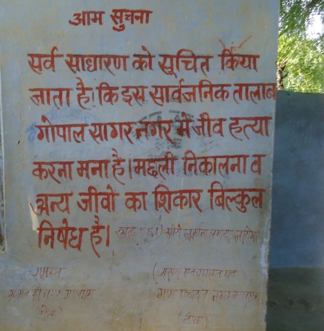
Participants from other states Pankaj Shrivastava from Mahoba appreciated that communities in GVNML area have system of imposing fines when anyone is caught polluting the lakes (as reflected in the wall writing in the photo below at the Nagar village tank).
The wall writing at the tank in Nagar village explains the fine system
He also said that the communities in their area is trying to clean up Kiratsagar lake in Mahoba through a focused campaign since Oct 5, 2013. Mavjibhai from Vivekanand Research & Training Institute, Bhuj (Kutch in Gujarat) said that they plan to take up implementation of chauka system in 55 villages along the 60 km long Rukmawati river in their area.
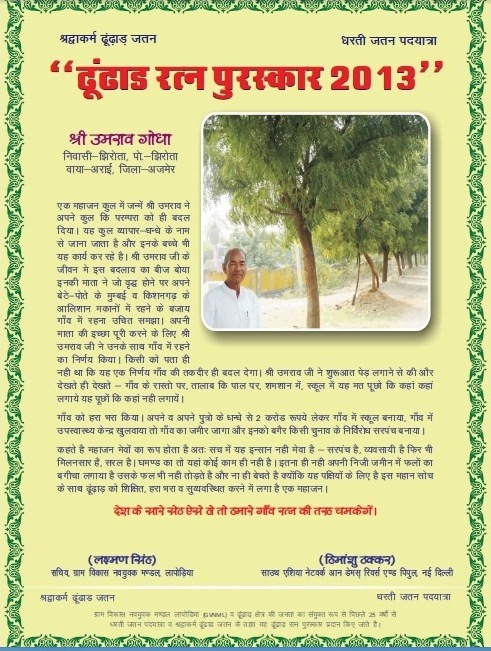
The Awards The five awards presented on this occasion were indeed very well deserved ones. The managing committee of Akodiya village (Dist Ajmer) was recognised for the tradition of collective management of common property resources including grazing land and water harvesting systems.
Rajjak Sheikh of village Tikel (Block Dudu in Jaipur district) was honoured for planting long living trees like peepal, Banyan, neem and other local varieties along the tank embankment over the last five years through his own efforts. He also got the fisheries contract given for the village tank canceled and got some of the hunters caught at his own personal risk.
Next, Shravanlal Jaat, a shepherd of village Kalyanpura (Dudu, Jaipur) was given the Dhudhad Ratan prize for consistently planting large number of trees in grazing land and along the village tank with his own personal effort and expenses for more than five years and also taking care of the planted trees.
Efforts of Umrao Godha, a relatively rich man of village Jhirota in Ajmer district were recognised for transforming the village with institutions like school, health centre and also for planting and taking care of large number of villages. Enthused villagers elected him as village head.
Khivsingh Rajput, an old man of Bikhraniya Kalan village from relatively far off Nagaur district (Marwad area) was also honoured for his 20 year old campaign in the village to plant long living Banyan and other trees in very dry area. He also inspired people to donate money and collected Rs 5 lakhs to deepen, renovate and strengthen the village tank.
Relevance for climate change The work of GVNML in the region is remarkable in many respects. The water conservation work helps recharge the groundwater and this water is then available in years of deficit rainfall, the frequency of which is bound to increasing in warming climate. Similarly, the whole area has created such a remarkable water conservation system that even when rainfall is excessive, this area will not face any floods since the water will be stored and only slowly released. The soil here has increased carbon content which also helps hold the moisture much longer, thus helping overcome the dry spells which has also increased in recent years. Thus it is clear that the that is underway over the last over three decades under GVNML has huge implications in the climate change context. The COP 19 talks at Warsaw remains deadlocked, waiting for some façade to emerge to show progress, this different COP 27 at Nagar shows so much progress is possible when the communities are at the helm of the affairs. It is doubtful though that the lessons from COP 27 at Nagar will have any impact on COP 19 at far away Warsaw.
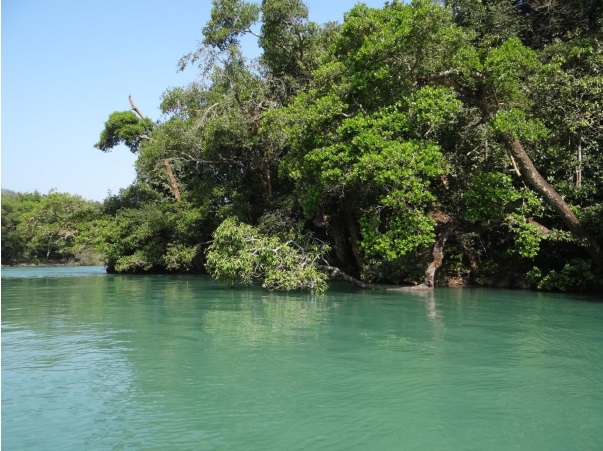
River Kali, before it enters Dandeli in Karnataka is a breathtaking sight..
Its waters are emerald green, flowing steadily. Its banks are thickly forested with a continuous canopy. Endemic species like Malabar Giant Squirrel, Malabar Pied Hornbills, Malabar Gray Hornbills are a common sight here. Down the river, a monitor lizard is stretched across a branch, low over the waters. Fishing eagles and several kinds of Kingfishers look for fish. Fisher folk hover along the banks in beautiful coracles, laying hooks in the riparian vegetation.
During our visit to the Kali, my six-year-old swam in the river and could not believe that the river back in his home-town was once as clear as this!
Emerald waters of the Kali Photo: Author
It’s hard to imagine that it was a touch-and-go for this stretch of Kali…
If it were not for some brave, timely advocacy and strong local action, most of this stretch would have been submerged. Rest of the river would have been diverted through a tunnel or silenced in a steady pool of a reservoir: the way many Indian rivers are silenced. There would have been no river, no riparian forests and possibly no swimming.
Malabar Pied and Malabar Gray Hornbills on the banks of Kali Photo: Author
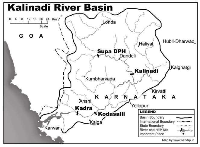
Dams on Kali: Kali has seen far too much damming. According to Kali Bachao Andolan, a network of organizations working to protect Kali River, more than 5 dams across the river have already submerged 32,000 acres of forests in the Western Ghats. According to Karnataka Power Corporation website, “The west flowing Kalinadi has its origin at an elevation of 900 m, near the DiggiVillage in the Western Ghats of Karnataka. Its 180-km long journey ends at the Arabian Sea near Karwar.”
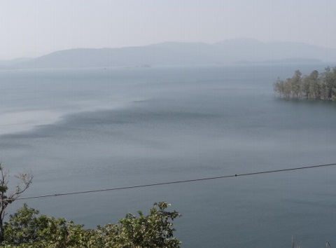
After its origin, it’s dammed at Supa in Joida Taluk of the Uttara Kannada District. The submergence of Supa Dam is a site to behold. Stretching endlessly like an ocean, this dam submerged more than 24 villages and hundreds of hectares of forests. One of the dam evictees, an old, frail man now tells me, “Even now in summers, when the waters recede, I can see my village and my temple. We try to go there some times. I can see all my past life there, for a brief period, before it all goes under water again”.
Extensive submergence of the Supa Dam Photo: Author
Downstream the 101 m-high Supa Dam (100 MW), the river flows down through Dandeli town, taking huge pollution from West Coast Paper Mills on the way. From here it is dammed at Bomanhalli Pick up Dam, from where it is diverted to Nagazhari Powerhouse (870 MW), then to Kodasalli Dam and powerhouse (120 MW) and then at Kadra Dam and powerhouse (150 MW). If we look at the flow chart of Kali Nadi Dams, the river seems to be flowing from one reservoir into the next, with nearly no free flowing river stretch between two dams. Its main tributaries Kaneri and Tatihalla have been dammed too.[1] The power generation performance of Kali dams for the last 27 years is shown in the graph above.
There is a stretch downstream the Supa dam to Bomanhalli Pick up dam, where the Kali still flows. This again is controlled flow, regulated by the Supa Dam. But this is the precise stretch which was also targeted to be dammed in 2000’s. An 18 MW project by Murudeshwar Power Corporation Limited (MPCL) was proposed to come up at Mavlangi village downstream Supa Dam. According to Kali Bachao Andolan, it would have meant submergence of 210 hectares of land, including 70 hectares of forest land, next to the Dandeli Sanctuary. Kali Bachao Andolan, including Parisar Samrakshana Samiti, Sirsi and Environment Support Group (ESG), Bangalore, highlighted that Uttar Kannada District only needed 17 MW electricity (in 2000) while it was producing more than 1200 MW electricity and one more dam at a huge social and ecological costs cannot be justified. More importantly, ESG exposed that the Rapid EIA (Environment Impact Assessment) report done by reputed consultancy Ernst and Young for the proponent, was in fact a copy-paste of a different EIA, done by a different agency for a different river! A strong campaign was built around this, which garnered public and media support.
Guide from one of the homestay-resorts, a resident of Dandeli Photo: Author
In 2006, the Forest Advisory Committee of the MoEF rejected Forest Clearance for this project. The project was also strongly opposed internally within the Karnataka Government by the Department of Tourism. Surprisingly, MoEF did not book the EIA agent (Ernst and Young) or the proponent (MPCL) for submitting an entirely false report! Even more shockingly, this EIA was later done by TERI (The Energy Research Institute), which also completed the study in one month and came up with a dubious report based on secondary data. However, strong opposition from local groups, ESG, and even within Karnataka Government resulted in rejection of the proposal by a number of authorities, including the Department of Industries and Collectorate of Uttar Kannada. Since then, the project has tried to raise its head again, only to be opposed strongly.[2]
Fishing along the Kali in the early morning Photo: Author
Around 10 years down the line, what does this small stretch of free flowing river mean?
I traveled in Uttara Kannada as a tourist in November 2013. A thriving tourism industry now exists on the banks of Kali and the river is now world-renowned as one of the best rivers for white-water rafting in India. There is boating, canoeing, kayaking, swimming, fishing along this stretch of the river. Pools and islands in the river provide perfect habitats for various species as well as for naturalists and bird watchers. The range of recreational activities that take place along the river are endless. Fishermen still lay their nets across this stretch and catch some fish (though I was told that fish greatly reduced after Supa Dam was commissioned in 1985). Along the banks of the river in this stretch, a thick riparian forest flourishes, providing habitat and corridor to several species.
But more importantly, this tiny stretch is a reminder of how this great river once was. A humbling reminder.
According to Lal, now a boatman and guide from Dandeli, the river stretch which could have been dammed, now provides tourism related employment to around 1000 people from around the region. The region supports around 8 resorts and several homestays. It has created multiple employment opportunities for locals like naturalists, guides, white-water trainers, etc. Some of the locals are descendants of the Supa Dam evictees. One of them says, “The relocated colony of Supa evictees is called Ramnagara, actually it is Vanvasanagara. If it were not for the tourism, I would have migrated to Goa or Belgaon. We saw the fate of Supa dam displaced and would not allow one more dam, no matter how small or big, to affect us again.”
Many ways to enjoy a flowing river: Rafting, canoeing, swimming Photo: Author
The struggle against 18 MW mini hydel has been significant in a number of ways. EIA and public hearing for the project were the two events where protests were recorded. It was through these platforms that the extent of the impacts of the projects was known and could be opposed. However, after this, a newer version of EIA Notification was adopted in Sept 2006 which excludes hydel projects below 25 MW from its ambit! This has been a ecologically senseless move as projects which have severe impacts on the ecology do not even need a public hearing and an EIA now! We, and several experts and organizations, have raised this point a number of times with the MoEF, but MoEF is yet to respond.
One more strong point of the struggle was a more than 20-year-old order by Karnataka government categorically stating that since the Kali river is so heavily dammed (five major dams on this short 186 kilometre long river, destroying most of its forests and displacing thousands of tribal and forest dwelling communities), no more dams, big or small, shall be allowed further across this river. This has been a very significant order.
Even today, when more and more bumper to bumper dams in the Himalayas and Western Ghats are killing our rivers, our Ministry of Environment and Forests does not have a clear guideline for protecting certain stretches of rivers from dams or declaring them as no-dam stretches. There exists no such order protecting over-dammed, collapsing rivers.The only report which actually recommended that 24 dams in the Upper Ganga basin should be dropped due to their impact on ecosystems, has not been complied with by the MoEF. Dams are coming up in cascades, without leaving any free-flowing riverine stretch between two projects. Nothing is being done about this. The MoEF’s Expert Appraisal Committee on River Valley Projects now has a weak norm of leaving a bare kilometer of flowing river between projects. But this norm too gets twisted and violated.
Avay Shukla committee appointed by Himachal Pradesh High Court recommended that projects should have at least 5 kilometers of free flowing river between them. But MoEF does not seem to support this. In fact, a flowing river seems to have no value in our governance system.
However, as the Kali experience shows, a flowing river is good for ecology and is good for the people too.
Let us take this opportunity to thank the Kali Bachao Andolan and the local communities for protecting the last remaining free flowing stretch of Kali… so that we can catch a glimpse of how a free-flowing river looks like!
– Parineeta Dandekar
Local children rafting along the Kali Photo: Author
The Mohanpura Project The proposed Mohanpura dam is to be constructed by the Madhya Pradesh Water Resources Deparment near the village Banskhedi of District Rajgarh, Madhya Pradesh on river Newaj in ChambalRiver Basin. The earthen dam project envisages irrigation of 97,750 ha, including the irrigable area of 62250 ha in Rabi and 35500 ha in Kharif in Rajgarh and Khilchipur Tehsils of Rajgarh district. The Environmental Impact Assessment (EIA) dated May 2013 has been done by WAPCOS, an agency under Union Water Resources Ministry.
Site of the proposed Mohanpura Dam (Source: EIA)
The EIA and the EAC We have provided below some critical comments on the EIA, these are only indicative in nature and not comprehensive. These comments were sent to the Ministry of Environment and Forests’ Expert Appraisal Committee (EAC) on River Valley Projects for its meeting in June 2013 and further comments for Sept 2013 and Nov 2013 EAC meetings. We were glad that EAC asked the project proponent to reply to our submission in detail. But we did not get any reply directly either from the project proponent or MoEF. We several times checked the relevant section of MoEF website before the Nov 11-12, 2013 EAC meeting and did not find any additional submission from the project proponent or EIA consultant except the EIA and earlier submissions. We also wrote to the EAC and MoEF officials about this absence of any response from the proponent or the EIA consultant and they did not respond to our emails.
However, while looking for something else, on Nov 13, 2013, on clicking the EIA (which we assumed was the old EIA), what we got was the Oct 2013 response from the project proponent that supposedly included the response from WAPCOS to our submission. This seems like an attempt on the part of MoEF officials to camouflage/ hide the reply so that the reply is put up, but we do no get a chance to review and respond to it. This is clearly wrong and we have written on Nov 13, 2013 to that effect to the MoEF director Mr B B Barman who is also member secretary of the EAC.
Location map of the Mohanpura Project (Source: EIA)
In any case, the WAPCOS reply of Oct 2013 does not really provide adequate response to any of the points we raised as we have discussed in the following sections. If the EAC had applied its mind, EAC too would have come to the same conclusion. However, if EAC decides to recommend clearance to the project based on this reply by WAPCOS, it will not only show lack of application of mind and bias on the part of the EAC, the project clearance would also be open to legal challenge.
In what follows we have provided main critiques of the EIA and the project.
EIA does not mention that the project is part of Inter-Linking of Rivers The Mohanpura dam is part of the Government of India’s Interlinking of Rivers scheme, specifically part of the Parbati-Kalisindh-Chambal (PKC) scheme, see for example the mention of Mohanpura dam on Newaj river in salient features of the PKC scheme at: http://nwda.gov.in/writereaddata/linkimages/7740745524.PDF, the full feasibility report of the PKC scheme can be seen at: http://nwda.gov.in/index4.asp?ssslid=36&subsubsublinkid=24&langid=1. This hiding of this crucial information by the Project Proponent is tantamount to misleading the EAC and MoEF and should invite action under EIA notification. The claim by WAPCOS (through their response in Oct 2013) that this was mentioned in DPR is clearly not tenable since this should have been mentioned in the EIA.
Much bigger Mohanpura Reservoir proposed compared to the PKC proposal It is clear from the perusal of the Feasibility of the PKC link given on the NWDA link that the project now proposed by the Govt of Madhya Pradesh is much bigger and actually an unviable scheme. The Gross and live storage of the NWDA scheme is 140 MCM and 52.5 MCM, where as the proposal now before the EAC has gross storage of 616.27 MCM and live storage of 539.42 MCM (page 1-328 mentions Live storage as 616 MCM, showing another instance of shoddy work of WAPCOS), which means the live storage proposed now is more than ten times the live storage proposed in NWDA scheme. It may be noted that there is less than 4% difference in catchment area of the two schemes, the NWDA site was slightly upstream with the catchment area of 3594 sq km, compared to catchment area of now proposed scheme being 3726 sq km, the difference between the two is only 132 sq km.
This does not warrant or justify more than ten time higher live storage. In fact the NWDA scheme had the proposal to transfer 464 MCM from the Patanpur Dam to the Mohanpura dam and yet, under the Mohanpura live storage capacity proposed under NWDA scheme was much smaller. It is clear that the proposal before NWDA is completely unviable proposal and should be rejected.
No justification for increasing the live storage capacity OVER TEN TIMES This is a very serious issue and unless this is satisfactorily resolved, EAC should not consider the proposal.
Here it should be point out that the following discussion in the 67th EAC meeting regarding the SANDRP letter is misleading: “The developers were asked to clarify doubts raised in the above letters relating to the project features that contradict with the assumptions made in the NWDA study of Parbati – Kalisindh – Chambal Scheme, a major issue is that the NWDA scheme envisaged a gross and live storage provision of 140 and 52.5 MCM respectively against the present proposal 616.27 and 539.42 MCM respectively because the NWDA proposed transferring 464 MCM from Patanpur dam to Mohanpura Reservoir to reduce the large submergence of Mohanpura Reservoir. The developers clarified that the NWDA scheme has not been accepted by the M.P. Government and is not likely to be implemented in the near future. The M. P. Government wants immediate implementation of Mohanpura Project for poverty alleviation of the backward Rajgarh District.”
The issue is not only about how NWDA plans differed from the current proposal in terms of transferring 464 MCM water to Mohanpura dam from Patanpur dam and transferring 403 MCM from Mohanpura dam to Kundaliya dam. Net effect of these two transfers is addition of less than about 61 MCM water to Mohanpura dam in NWDA proposal from outside the Newaj basin. In spite of this addition, the storage capacity of the Mohanpura dam in NWDA proposal is HUGELY LOWER than in the current GOMP proposal. There is clearly no justification for such huge storage capacity from any angle. Even the water use plan has exaggerated figures and does not change even with changed cropping pattern. The issue is the viability, desirability, need and optimality of the ten times larger reservoir than was NWDA proposed earlier.
Unfounded assumption about water availability The project assumes huge yield of 745.2 MCM, much higher than that assessed by the Chambal Master Plan, without assigning any reason. This seems to be a ploy to push for unjustifiably huge reservoir. This is clearly wrong and the proposal should be rejected. The reply by WAPCOS that “The calculated yield of dam is approved by Bureau of Design of Hydel & Irrigation Project (BODHI), M.P.” is not convincing since BODHI is government of Madhya Pradesh organisation and in any case, their approval letter and methodology details have not been attached. In any case, Newaj being in interstate Chambal river basin, it will need vetting by the interstate Chambal River Board or credible independent body.
Inadequate assessment of upstream water requirement The EIA does not do proper or adequate assessment of current and future water requirements of upstream areas and allocates almost all available water in the catchment to the project in a bid to justify unjustifiable project. The figures given in table 10.9 are not even substantiated with any basis and hence are far from adequate in the context. The PP has also not responded to the EAC query about the upstream water demand.
Unjustifiable submergence The proposal entails submergence of 7051 Ha, almost three times the submergence as per NWDA scheme of 2510 ha. The project proponent has hugely underestimated the number of affected families to 1800 against private land acquisition of 5163 ha. They have amazingly, allotted just 132 ha of land for R&R, when land for land provisions under the MP R&R policy will require much more than 5000 ha just for R&R. The social impact assessment has not been done at all. In fact the phrase Social Impact Assessment or Social Impact does not figure in the entire EIA, when the National Green Tribunal has been laying such a stress on SIA.
The whole social impact assessment of the proposal now submitted is shoddy. It is clear the huge displacement is unjustified, and the project proponent has no interest in even doing any just rehabilitation. The PP has not explained the justification for three times increasing the submergence area compared to the NWDA proposal.
Interstate aspects ignored The project is coming up on an interstate river basin and will have clear implications for the downstream state of Rajasthan, but there is no mention of this in the EIA. Several meetings have also happened between Madhya Pradesh and Rajasthan about the PKC link mentioned above. The Government of India has prioritized this link, but by taking up this project unilaterally without consent of Rajasthan or Centre (Ministry of Water Resources) the Madhya Pradesh government is violating the interstate and federal norms. The EIA does not even mention any of these issues.
Underestimation of Land required for Canal The project has command area of 97750 ha and claims that it will require just 152 ha of land for canals (table 2.6 of EIA), which is clearly a huge under estimate and is not based on any real assessment. The project will require several times more land for the canals and will have related social and environmental impacts which have not even been assessed. The response from WAPCOS that this is because most of the water conveyance system is underground is far from adequate since an assessment of land requirement should still have been done and a lot of land would still be required at the end of water conveyance system.
No Command Area Development Plan The EIA report (May 2013) mentions CAD in two sections: Section 2.8 and 10.9. However, perusal of both sections show that neither have full description of Command Area Development Plan or adverse Impacts of the project in the Command Area including drainage, health, biodiversity and other issues.
Shocking statements in Command Area Development Plan The CAD now annexed in the Additional information (dated Aug 2013) makes some shocking statements. e.g. It says: “GCA of the project is 928680 ha…” with an extra “0”. This seems to suggest that the EIA consultant is callous.
The CAD further says: “Maximum height of the spillway above the ground will be 47.90 m (measured from river bed level to top of the spillway bridge). Maximum height of spillway from expected foundation level will be 47.90 m.” So the height of the spillway above the riverbed and above the foundation is same! This means that there is no foundation of the dam below the riverbed level! This again shows the callousness and lack of understanding of basic concepts by WAPCOS.
Section 2.9 of CAD says: “The groundwater development is of the order of 6.9% to 8.7% in the command area blocks.” In reality, as the table 2-3 just below this statement shows, the groundwater draft is 69 to 89%.
Section 3.1 of CAD says: “…the catchment area intercepted upto Mohanpura dam site is 3825 sq.km.” The last sentence in the same para says: “The catchment area intercepted at the dam site is 3726 sq.km.” Such figures for the catchment area upto Mohanpura dam keeps appearing in the documents.
The CAD should start with clear statement of HOW MUCH OF THE PROPOSED COMMAND AREA IS ALREADY IRRIGATED. This is not even mentioned.
No Downstream Impact Assessment The EIA report has not done any downstream impact assessment, including the impact on biodiversity, livelihoods, draw down agriculture, water security, groundwater recharge, geo-morphological impacts, among others. The response of WAPCOS in Oct 2013 that Newaj is a monsoon fed river and hence there are no downstream impacts is completely inadequate and shows the lack of understanding of functions of the river on the part of WAPCOS.
Impact of project on National Chambal Sanctuary It may be noted that the project is to be constructed on Newaj river, a tributary of the Chambal river. The project will have significant impact of water, silt and nutrient flow pattern into the ChambalRiver, the approximate 600 km of which has been declared as National Chambal Sanctuary between 1979-1983 across three states of Madhya Pradesh, Rajasthan and Uttar Pradesh. However, the EIA does not even mention that the National Chambal Sanctuary exists down stream of the proposed project and will be impacted by the project. According to section 29 of the Wildlife Protection Act of 1972, any project that affects flow of water into or out of the protected area should be assessed for its impact on such sanctuary and necessary clearances be taken from the designated authorities including Chief Wildlife Wardens and National Wild Life Board. However, WAPCOS does not even seem aware of the existence of the sanctuary.
Another point to note is that the entire water availability in the NCS is dependent on the KaliSindh and Parbati since there is no discharge below the Kota Barrage. The response from WAPCOS (Oct 2013) that the Mohanpura catchment is about 200 km from the river and that it is just 2.5% of the Chambal catchment and hence will not have any impact is clearly untenable. Firstly, the EIA does not even mention the existence of National Chambal Sanctuary. Secondly, it is not the distance of % catchment, but the impact of the abstraction that is important and the EIA has clearly not done that.
Impact of mining of materials for the project not mentioned The EIA has some assessment of material required to be mined for the project at Table 2.7, but where will these materials come from and what will be the impacts of this is not even mentioned.
No proper Options Assessment The EIA does not do proper options assessment to arrive at the conclusion that the proposed project is the most optimum proposal. It may be noted that the area has rainfall of 972 mm (see Chapter 2 in Command Area Dev Plan in Additional Information dated Aug 2013) and there are a lot of options for local water systems. As is clear from the public hearing report, several farmers suggested that in stead of one big dam a series of smaller dams should be built and that farmers will have to commit suicide if the dam is built. The response in the EIA is most callous that this is not technically feasible is not even backed by any evidence, which again shows the shoddy nature of the EIA.
The response of WAPCOS (Oct 2013) that the project is justified for fluoride affected area is completely misleading since if that was the concern than much smaller dam and large number of rain water harvesting structures would better serve the purpose. This again shows that WAPCOS has not done any options assessment.
Public hearing in the office of the DM? Chapter 17 of the EIA says, “Public Hearing for Mohanpura Multipurpose Major Project was conducted by Madhya Pradesh State Pollution Control Board (MPPCB) on 11th March 2013 in the premises of the office of the District Magistrate, Rajgarh”. This is most shocking state of affairs. The Public hearing as per the EIA notification is supposed to be conducted at the project site and cannot be conducted in the office of the District Magistrate. The MoEF should have applied its mind on just this aspect and rejected the proposal and asked them to get the public hearing done in legal way. The public hearing report is also incomplete with several sentences not being complete. This again shows lack of application of mind on the part of the MoEF and WAPCOS. The response from WAPCOS in Oct 2013 that the DM office is just 9 km from the dam site and is convenient to all concerned is clearly wrong, the public hearing should have been conducted in the affected area and public hearing report should be full and cannot be accepted with half sentences. This public hearing will also not pass the legal scrutiny.
CUMULATIVE IMPACT ASSESSMENT FOR CHAMBAL BASIN A very large number of dams and other water use projects have been constructed, are under construction and under sanction in the ChambalRiver Basin. It is high time that a Cumulative Impact Assessment (CIA) and carrying capacity study for the ChambalBasin be done before any more projects are considered in the basin. This is also required as per the MoEF Office Memorandum (J-11013/1/2013-IA-1 dated May 28, 2013) that required states to initiate CIA in all basins within three months, that is by Aug 28, 2013.
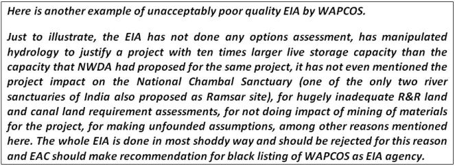
Unacceptable EIA The whole EIA is done in most shoddy way and should be rejected for this reason and EAC should make recommendation for black listing of WAPCOS as EIA agency. Just to illustrate, the EIA says MDDL stands for Maximum Draw Down level (page 1-14), has not even mentioned the project impact on the National Chambal Sanctuary (one of the only two river sanctuaries of India also proposed as Ramsar site), for hugely inadequate R&R land and canal land requirements, for not doing impact of mining of materials for the project, for not assessing the hydrological viability of the project, for making unfounded assumptions, among other reasons mentioned above.
Issue of Conflict of Interest for WAPCOS It may be noted that WAPCOS is a Ministry of Water Resources organization, and has been in the business of doing pre-feasibility, feasibility reports and Detailed Project Reports, which are necessary for the justification of the projects. This is part of the business of the organization. Such an organization has clear conflict of interest in doing an honest EIA since an honest EIA can lead to a possible answer that the project is not viable. Hence EAC should recommend that the WAPCOS should be debarred from doing any EIAs or CIAs (Cumulative Impact Assessments).
Other Issues Besides the above, a large number of issues raised by EAC in 67th meeting remain unresolved.
Þ For example, the area to be inundated by dam break needs to be listed and shown on map, which has not been done.
Þ EAC had asked: “Details of drainage network planning be included in the report.” In response, PP has attached Annex III which is just a map!
Þ EAC had asked: “75%flow series gives a total yield of catchment as 25.77 cumec-10 days in 75% dependable year. Whereas in table-5.2 the 75% dependable yield is given as 749.71 Mcm. The same needs to be corrected. Corresponding corrections at relevant sections in Volume-II, EMP report also be done”. This has not been done except an amended table
Þ Annex XIV in Additional Info on “INCOME – EXPENDITURE DETAILS OF PAFs” leaves a lot to be desired. Here, what does the figures represent in Table 1 is also not clear.
Þ Annex XV in Additional Info volume is basically a reproduction of 10.11.6 from the EIA. Incidentally, it ends by saying: “Project planner need to understand the negative impacts with sensitivity, and formulate mitigation measures appropriately; such mitigations measures that would be acceptable to the concerned population groups and that are sustainable.” The proposed project or the R&R plan are neither acceptable to the concerned population groups, nor sustainable, in any case, there is no process to achieve this.
Þ EAC had asked for more no of villages in the sample compared to 9, but the EIA consultant has refused to do this (Annex XVI and XVII in additional Info) without any convincing reason.
CONCLUSION In view of the above, we urge EAC to:
1. Reject the proposal for environmental clearance. It will be most shocking if the project gets cleared with this kind of EIA.
2. Reject the EIA, as explained above this is most shoddy EIA.
3. Reject the Public hearing; as explained above, the public hearing has not been conducted as legally required. The public hearing also need to be conducted again since the EIA is found to be so seriously inadequate and needs to be redone. In any case, with so many additions and changes to the EIA, the public hearing clearly needs to be redone.
4. Suggest black listing of WAPCOS as EIA and CIA agency. It is high time for EAC to send a signal that such shoddy EIA would not be accepted and is in violation of law.
Submission showing how the WAPCOS EIA of Mohanpura Project is Inadequate and Plagiarised
Sep 23, 2013
To,
Chairman and members,
Expert Appraisal Committee on RiverValley Projects,
Ministry of Environment and Forests,
New Delhi Subject: Serious concerns on the Mohanpura Irrigation Project on agenda for the 68th meeting of EAC of RVP
Dear Chairman and Members of the EAC-RVP,
With reference to the Mohanpura Irrigation Project on agenda for the 68th meeting of the Expert Appraisal Committee on River Valley Projects, and WAPCOS response to EAC comments (August 2013), I believe that the concerns raised by the New Delhi based SANDRP has not been addressed. The Project Proponent has also not responded satisfactorily to the queries raised by the EAC, and I outline a few of their (WAPCOS) responses below –
EAC Comment No. 16: The source of data for faunal population is to be provided. The source of secondary information may be provided if used.
EAC Comment No. 17: The avifaunal list is good but requires a lot of typographical corrections. Also some of the species such as Golden Plover and Redshank have been shown as resident although they are migratory.
EAC Comment No. 18: The list of reptiles appears deficient for this hot and dry area of central India. This needs to be updated. The information provided by WAPCOS under-represents the faunal richness of the region and is an attempt to deceive the Expert Appraisal Committee on River Valley Projects. The sources used in the EIA are old and I would like to draw you attention to more recent work from the region (attached below).
Nair, T. & Krishna, Y. C. (2013). Vertebrate fauna of the ChambalRiver Basin, with emphasis on the National Chambal Sanctuary. Journal of Threatened Taxa, 5(2): 3620–3641; doi:10.11609/JoTT.o3238.3620-41
EAC Comment No. 19: The methodology for faunal surveys has not been provided properly. The faunal part in section 4.2.2 is too brief and fails to provide any idea about the primary effort. The source of secondary information may be provided if used. The methodology outlined in Annexure-XII by WAPCOS has simply been copied from other survey reports / studies without actually conducting them. This amounts to professional dishonesty and fraud, and is another attempt to deceive the EAC-RVP.
Eg: “Direct Count: Both terrestrial and arboreal (small and large) mammals were counted during monitoring of line transect (Burnham et al. 1980) that were walked in the early and late hours of the day, and during the night using spotlight or headlights (Duckworth 1992).” is plagiarised fromhttp://fes.org.in/studies/sitamata-report-final-july.pdf?file=ZG93bmxvYWQvd3AxOS5wZGY=
“Indirect Count: Presence and relative abundance of most of the small and large mammals was evaluated using methods that rely on indirect evidence such as animal burrows/holes, dung, pellets, scats, feeding signs, tracks, nests, digging and antler thrashing.” is also plagiarised fromhttp://fes.org.in/studies/sitamata-report-final-july.pdf?file=ZG93bmxvYWQvd3AxOS5wZGY=
“Line Transect useful in determining variation in herpetofaunal populations across continuously changing environmental gradients (Jaeger, 1994). Thus, systematic searches can be used to provide data for distribution, inventory, relative abundance, density estimates, population trends, site occupancy and territory mapping.” is plagiarised fromhttp://www.outdooralabama.com/research-mgmt/State%20Wildlife%20Grants/AL_AM_Final_Report.pdf
EAC Comment No. 20: The presence/absence of Blackbuck, a Schedule-I species, may be commented upon since it is expected in the area. WAPCOS response that ‘Blackbuck is not reported in the area’ is again not true. Please refer to the press report and scientific study which show the presence of black buck from the area. Press report: http://articles.timesofindia.indiatimes.com/2013-01-05/flora-fauna/36162066_1_blackbuck-population-stray-dogs-habitat Scientific publication: Karanth, K. K., Nichols, J. D., Hines, J. E., Karanth, K. U. and Christensen, N. L. (2009), Patterns and determinants of mammal species occurrence in India. Journal of Applied Ecology, 46: 1189–1200. doi: 10.1111/j.1365-2664.2009.01710.x I believe that such a manner of plagiarism and false claims of having used scientific methods during the Environmental Impact Assessment is reason enough to reject the project and to blacklist WAPCOS. Further, the Government must initiate civil and criminal proceedings against WAPCOS for fraud, suppressing facts and providing misleading information on an issue that has serious and negative ecological and social consequences.
It is becoming increasingly evident that ‘rivers’ do not figure anywhere in the entire e flows discourse and assessments going on at Government level in India. We have so many different types of e-flows assessments being tried out.
Multiple agencies, but where are the flows? At least 69 hydro power projects are in various stages of development in Alaknanda – Bhagirathi sub basins of the Ganga (as per IMG records). Four different e-flow regimes based on different approaches have been put forward by the four different agencies. While AHEC (Alternate Hydro Electricity Centre) has used Mean Annual Flows (MAF), WII (Wildlife Institute of India) has resorted to Mean Seasonal Runoff (MSR) for different seasons based on the needs of the fishes. CWC (Central Water Commission) has resorted to ad-hoc e flows of 20 % of daily flows. IMG (Inter-Ministerial Group) has come out with its own recommendation of percentage of daily inflows for different seasons going upto 50 % for winter season from December – March where winter flows are very low.
The beautiful Nyamjangchu River, Tawang, Arunachal Pradesh, now threatened by the 780 MW Nyamjangchu Hydel Project and very low eflows recommendation Photo courtesy: Tenzing Rab Monpa
While admitting that Building Block Methodology (BBM) is the most comprehensive holistic methodology, IMG report claims (without basis) that since it is time consuming and since it has not been tried out in any large river basin, interim e-flows recommendations be done so that hydro power development is not held up for want of environmental decisions. Mind you, this is the case with all the rivers where hydro power projects are being planned. While many of the project developers and EIA agencies claim that they follow BBM methodology, it is evident that none of these fulfill the requirements of a comprehensive BBM methodology. So who cares about the rivers here?
NIH workshop on Oct 2-3, 2013 without MoEF! The National Workshop on Environmental flows organized by the National Institute of Hydrology (NIH), Roorkee along with UK based Centre for Ecology and Hydrology (CEH) during 2-3 Oct 2013 only reinforced my conviction that what is going on in the name of e flows assessment is indeed not for any goodwill for the rivers. The workshop was conspicuous by the absence of MoEF officials whose main mandate is protecting river ecosystems and life in rivers. Were they not invited or did they decide not to participate? It was mostly dominated by technical persons and organisations who believe that rivers are for the exploitation by humans alone mostly through mega projects. The workshop agenda was set on the oft repeated dictum that e flows should be integrated into water resources development, without any will for such integration.
E-flows are for rivers In India e flows is just a formality to fulfill the requirements of the environmental clearance process. Ironically, resource persons from countries outside India with ample experience on e flows assessment pointed out that the intention was to find ways to ‘limit’ or mitigate the impacts of development. If the agenda had been set with the intention that e flows should be part of river conservation and not just to fulfill the development agenda then we would have some hope for rivers.
Developers don’t want any e-flows Project developers are clearly unhappy with even the meager allocation in the name of e flows. The dam builders like the NHPC, Uttaranchal Jal Vidyut Nigam Ltd. and Tehri Hydro Power Corporation claimed that they are actually releasing more water than they are ‘asked to’! This is indeed ridiculous. Even what they are ‘asked to’ release does not amount to e-flows and is not based on any comprehensive assessment or community validation! And there is clear evidence that they are not releasing even that (e.g. NHPC’s Teesta V or Tehri). Then where does the question of reducing e-flows allocation below dams arise? They even went to the extent of recommending that in those rivers where tributaries join the dry stretch below the dam, can’t e flows allocation be reduced and can’t the tributary contribution added as e flows? Can’t e flow releases be used for power generation by installing dam toe power houses? For them e flows is mere ‘cumecs’ (Cubic meters per second) of water to be released and nor do they understand that each tributary and the main stem of the river have their own ecological niches & functions; and social and cultural dependencies which are linked to the flows in each of these.
Dhauliganga before the June 2013 disaster, with zero water flow downstream from the dam, killing a perennial river. Source: Emmanuel Theophilus
The presentations made by NIH Roorkee, CIFRI (Central Inland Fisheries Research Institute), GBPIHED (GP Pant Institute of Himalayan Environment and Development) and AHEC for proposed hydro power projects in the Himalayas and the North East India revealed that none of the studies had carried out consultations with river dependent communities and did not follow the BBM principles either.
CIFRI-NIH’s flawed assessment of Teesta IV HEP e-flows Teesta IV HEP proposed in Sikkim is presently under the scanner since many groups have raised the genuine concern with the MoEF (Ministry of Environment and Forests), EAC (Expert Appraisal Committee), FAC (Forest Advisory Committee) and the NBWL (National Board of Wild Life) that if implemented it would mean the death of the last free flowing stretch of the main Teesta river. The ToR (Terms of Reference) of the study commissioned by MoEF says, “An estimation to be made for environmental flows downstream forsustenance of aquatic environment and for downstream uses, considering details of streams joining the river below the proposed dam site with their approximate distance from the dam site, their nature (whether perennial or seasonal) etc. A detailed environmental flows study shall be carried out through the premier institutions such as Central Inland Fisheries Research Institute (CIFRI), Barrackpore and National Institute of Hydrology (NIH), Roorkee for biological and hydrological components”.
The consultants took just 7.5 km length of the river from dam axis to the existing downstream project Teesta V which is immediately downstream. The study carried out in 2009- 2010 period has prescribed a minimum discharge of 10 cumecs (Cubic Meters per second) from the dam during the lean period and 40 cumecs for wet season for aquatic life is also prescribed. The ToR has two objectives namely e flows for the sustenance of aquatic environment and for downstream uses, but the sampling parameters in the presentation does not reflect the fulfillment of these objectives.
Teesta V HEP Photo: Tehelka
Since the Teesta V is already commissioned, the impact below the dammed and flow regulated stretch of Teesta V on the aquatic environment and downstream uses would have given useful comparisons. The study seems to have ignored the e flows for downstream uses of communities even in the 7.5 km stretch. The study though claimed to have used the BBM methodology, it is doubtful if all the relevant building blocks have been considered. The study carried out in 2009-10 does not seem to be uploaded in public domain to date.
E-flows for all projects do not make sense? Most shockingly, the chief consultant for the Ganga River Basin Management Plan now being formulated by a consortium of IITs (Indian Institutes of Technology) Dr Vinod Tare was of the opinion that all projects to release e flows does not make sense. He said it is important to seek balance and generate power as well. Now this is problematic. Let us face it that in Indian conditions we are working on e-flows under data and information deficient conditions. We are still far away from understanding a river system in its complexity along with its basin characters, eco- hydrological interactions and land use changes.
Lack of Eco-hydrological understanding Even NIH engineers and other experts agreed during discussions that we lack reliable hydrological data and have absolutely very little ecological data base on our rivers to arrive at proper recommendations for e-flows. MoEF and NGRBA (National Ganga River Basin Authority) has meanwhile accepted BBM methodology (as in the NGRBA Report; Code – 022_GBP_IIT_EFL_SOA_01_Ver 1_Dec 2011) as the most robust assessment approach to e-flows and they also say it needs to be worked upon.
The report says, ‘The BBM methodology is found to be robust with high confidence level. However, specific flow recommendations are difficult to justify at this stage, and will have to be worked out afresh. The major uncertainties centered on the hydrological and hydraulic models due to lack of availability of reliable data’. In BBM all blocks are equally important as they interact with each other. Against such a scenario, Dr Tare needs to think twice before making such statements! They can be used by dam developers to lobby for reduced or even no flows.
What about e-flows from existing dams? Another missing element from e-flows at the NIH workshop that is bothersome was the lack of interest by the experts and the various authorized institutions in allocating e flows below already dammed rivers. They say it will be a tough job and would not be possible politically. However, ultimately e-flows is a social and political choice with trade offs and negotiations inbuilt into it. Does that imply that we can leave heavily dam ravaged rivers like the Mahanadi, Krishna, Cauvery, Narmada, Tapi, Sabarmati, Godavari, Teesta, Sutlej, Ravi, Beas, Chenab, Periyar and the like to die without allowing them at least their long overdue minimum flows leave alone e flows ? It is high time the Government took interest and started engagement and studies in arriving at and allocating e flows below dammed rivers.
The same Baspa, bone dry, about 5 kms downstream Baspa Dam. Photo: SANDRP Partners
Future challenges After two days of debate and disagreements, I came out of the workshop with the following thoughts at the top of my mind.
Several institutions in this country with expertise in ecology and hydrology and with necessary infrastructure who could have made efforts to put in place comprehensive e-flows assessment process are working for dam developers and serving as experts in EIA studies giving green signals to ill conceived hydro electric projects and dams based on inadequate e-flows recommendations. The level of dilution of science and ethics this can lead to is mind-boggling and with disastrous consequences for our rivers. For example e-flows and minimum environmental flows are being used as synonyms by many institutions including CWC. An interesting and dangerous recommendation from CWC at the workshop is; ‘If feasible, a separate storage of water in the upper reaches of a river basin maybe created for environmental needs which will help in augmenting flows during lean season and satisfy the e-flows demands particularly for Himalayan rivers’. So in future all river basins with dam cascades could be recommended with e-flows reservoirs!
What about compliance, MoEF? While e-flows have become mandatory for hydro power projects in this country, it is surprising and shocking that MoEF is yet to ensure compliance and to take up comprehensive and fundamental assessment of e-flows in sample river basins on its own which is its primary mandate. It is high time MoEF develops a ToR for e-flows from its conception to implementation to monitoring. E-flows assessment presently being carried out lacks proper objectives and mostly excludes communities from its purview or assessment. There is vagueness about what constitutes downstream in e-flows assessment. Even for the e flows assessment carried out in River Ganga for the NGRBA has there been any effort to implement the same? Has the MoEF ever tried to seek inputs on e flows from outside the government organisations or from the several groups working tirelessly for conservation of rivers?
Will NIH exercise have credibility? NIH in collaboration with many institutions proposes to take up sample river basins in India and put in place eco hydrological models for e flows. The absence of MoEF and members of the Expert Appraisal Committee on River Valley Projects at this workshop organized by a MoWR institution speaks for itself how e-flows will be realized if the mandatory ministry does not take a pro active role.
Some of the gaps and challenges in e flows assessment in Indian context include: lack of reliable data, lack of understanding of eco- hydrological linkages, river aquifer interactions, pollution related aspects (how to quantify and relate to flow releases), e-flow releases for flood plains, lack of resource allocation, lack of valuation of ecosystem services and societal – cultural value of rivers, multiple institutions working against each other’s interests (MoWR vs MoEF), Peaking induced flashiness, scientific and acceptable ways to compute e-flows and lastly but most importantly, effective implementation and monitoring.
Experts from other countries pointed out that rather than numbers it is better to have distribution ranges for e flows under Indian conditions with complex dependencies. They also made an important comment that uncertainty and risk factors never get integrated into our e-flows estimations. In India land use changes are also not accounted in e flows calculations.
The EIA of the Bansujara Multipurpose Project (BMP) dated May 2013 by WAPCOS has been submitted for Environment Clearance of the project before the Expert Appraisal Committee on River Valley Projects, in Nov 2013. WAPCOS is known to do very shoddy job of Environment Impact Assessments, this one is no different. In what follows I have given a few instances of wrong facts, contradictory facts, wrong calculations or assumptions, incomplete assessments, instances that shows it is cut and paste job and lack of options assessment by the 564 page EIA document. The conclusion is inescapable that the EAC and MoEF must reject this EIA and recommend black listing and other measures against WAPCOS. The project should be asked to get a fresh EIA done by a credible agency.
Location Map of Bansujara Irrigation Project
WRONG FACTS The EIA provides several completely wrong facts, here are a few instances:
1. River description On p 1-1 the EIA says: “The Bansujara Dam Project lies in Dhasan sub-basin of Betwa basin, River Betwa is a tributary of Yamuna river, rises in district Bhopal district at an elevation of 472 m. After traversing a length of 365 km, it joins Yamuna river in Uttar Pradesh. The river runs for nearly 240 km in Madhya Pradesh, 54 km along common border of Madhya Pradesh and Uttar Pradesh and 71 Km in Uttar Pradesh state before its confluence with Yamuna river near Hamirpur town in Hamirpur district of Uttar Pradesh.” This is actually the description of River Dhasan and not Betwa! It is exactly same as the description of river Dhasan given on the next page and several other places subsequently.
2. Land required for Canals In Table 2.3 it is stated that canals will require 44 ha land, this is clearly gross under-estimate considering even 49.9 km of main canal.
3.Private land under required for project The SIA says on page 1-2, “About 935.11 ha of culturable area, 57.49 ha of forest land and 4209.118 ha of other land including road, nallah, river, etc. will be affected.” This is blatantly wrong figure. On page 1-3/4 of SIA it is stated: “About 2935.11 ha of revenue/government land and 2894.37 ha of private land is to be acquired.” This again is wrong.
As the MoEF factsheet for the Forest clearance for the project says, “Apart from the 57.495 hectares of forest land proposed to be diverted, the project involves submergence of 287.951 hectares of government land and 4,856.276 hectares of private land.” Thus the suggestion by the SIA that only 935.11 ha of culturable land is going under submergence is clearly wrong since most of the private land is under cultivation in these villages.
4.How many families will be affected The MoEF Factsheet for the project says: “The project involves submergence of 21 villages. 2628 houses, 773 wells, 5082 trees, and 2628 families with population of 13,142 are getting affected due to submergence.” These figures are at variance with the figures mentioned in the EIA. For example, the SIA (p 1-4, repeated on page 4-1) says: “Over all 748 families of 9 Abadi Villages will be affected”. This when the project will be taking away 2628 houses as per the Fact sheet, is clearly gross wrong reporting of figures. Because of use of wrong figures, their R&R plan and R&R costs are also all wrong and gross under estimates. Moreover, now the R&R plan and costs should be as per the new Land Acquisition Act Passed by the Parliament, which has not been done in the EIA-SIA. As per the new Act, land has to be provided to each losing farmer, and this must be followed.
5. Completely impossible figures of crop yields A look at table 4.3 of SIA (repeated in table 7.1 of CADP) shows that the consultants have given crop yields before project (e.g. paddy 7 t/ha, wheat 18 t/ha, groundnut 10 t/ha and gram 10 t/ha) which are much higher than the average of even Punjab crop yields and they are expecting to double that post project! These are clearly impossible figures. This shows that the consultants are plain bluffing and seem to have no clue about possible crop yields and in any case do not seem to have done any surveys, but are only cooking up data. Amazingly, they are claiming that with 211% increase in crop yield, the profits from crops will go up by 318%! All this simply shows the manipulations they are indulging in to show the project is economically viable.
CONTRADICTORY FACTS 1.Main canal length Page 2-2 says main canal length is 90 km, the salient features on next page says Main canal length is 49.9 km.
2.Command area Tehsils and villages Section 10.2 of EIA (and again section 2.7 of the CADP) says: “The Command area of the proposed Bansujara Major Irrigation project lies within the district Tikamgarh in jatur and Baldeogarh tehsil” and than goes on to give details of these tehsils, but the rest of the document (e.g. section 6.1) says: “A total of 124 villages are likely to be benefitted by the project. 80 villages are located in Tehsil Khargapur of district Tikamgarh. About 13 villages are located in tehsil Jatara of district Tikamgarh. The remaining (31) villages are located in tehsil Palera of Chattarpur district.” Chapter 6 in fact provides full list of 124 villages in the command area. The subsequent details of the command area given in chapter 10 thus does not match with what is given say in chapter 6.
Contradicting this, page 1-4 of SIA says: “The Bansujara Multipurpose Project will benefit almost 132 villages in districts Tikamgarh and Chattarpur.” Amazingly, the SIA says Palera tehsil is in Tikamgarh district and not in Chattarpur district and that additional ten villages of Badamalhera tehsil of Chattarpur district will also be in command area!
Number of beneficiary villages in Palera tehsil are given as 31 in page 44 (chapter 6) and 30 on page 141 (chapter 11), with even names differing, e.g. Banne Khurd and Bastaguwan mentioned in chapter 6 are missing in chapter 11, village Bargram mentioned in chapter 11 is missing from the list in chapter 6.
All this is most callous and shocking. This fact alone should be sufficient to REJECT this callous EIA and recommend blacklisting and other punitive measures for WAPCOS as consultant.
3.Command area population Section 10.2.1 of EIA says: “As per 2001 Census the total population of the command area is about 38,000. The male and female population is 20,181 and 17,828”. However a look at the 10.2 that follows this sentence shows that these figures are for Jatara tehsil and not command area. Another sign of callousness.
4.Submergence villages Table 11.3 of EIA gives list of Project affected families, which is at variance with the list given in tables 10.8-10.14. Firstly, chapter 10 tables say that 14 villages of Tikamgarh Tehsil are affected, but table 11.3 lists only 13 villages. More shockingly, tables in chapter 10 say 6 villages of Bada Malhera tehsil of Chhatarpur district are affected, whereas the name of this tehsil given in chapter 11 is Bijawar. All this shows shocking callousness of WAPCOS.
5.Storage Capacity Page 11-10 says: “The storage capacity of Bansujara Reservoir is 539.42 Mm3.” This is clearly wrong, the figures for gross and live storage capacity given in salient features and elsewhere are: 313.1 MCM and 272.789 MCM respectively.
6.Water Availability As per Table 5.8, water availability at the project site from MP catchment (2788 sq km) alone is 843 MCM. Strangely, this reduces to 588.68 MCM in table 11.6 for whole of catchment (3331.776 sq km) at dam site. No explanation is given for these figures.
7.Submergence area While most of the document gives submergence area as 5201.71 ha. However, in section 2.7 of EMP, it says, “The submergence area of Bansujara Irrigation Project is 7476 ha.” This is amazing kind of contradiction.
WRONG CALCULATIONS/ ASSUMPTIONS 1.Field channel length grossly underestimated The p 6-6 of EIA says: “The Bansujara Dam Project envisages irrigation over a CCA of 54000 ha. In the areas where irrigation is proposed no field drainage, land shaping of field channels exist and used to be constructed. From general experience and existing practice, it is assessed that a length of 1600 m of field channels will be required to serve a chak of 40 ha of CCA. On this basis, an approximate network of total length of 180 km of field channels will be required for 50% of CCA proposed for irrigation.” Simple calculation suggests that the field channel length for 50% of CCA would be 1080 km (54000 ha / 40 ha per 1.6 km divided by 2 for 50% CCA).
2.Drainage requirement under estimated Section 6.9 (p 6-7) of EIA says, “The command area is being traversed by a large number of nallahs and drains, therefore field drainage should not pose any problem.” This is clearly wrong assumption since additional irrigation will certainly require additional drainage and cost calculations based on such flawed assumptions are bound to be wrong.
3.Baseless assumption about waterlogging Similarly about the assumption in section 6.13 (p 6-8): “Even after construction of Bansujara Dam Project the area will not face any waterlogging problem.”
4. Wrong claims about no floods The conclusion about flood and back water impacts is completely unfounded in section 6.14 (p 6-8): “As per information gathered from the Collectorate Tikamgarh there is no village affected due to back-water of Dhasan and Ur rivers. The existing drainage system in the command is adequate. The statistics gathered from collectorate Tikamgarh show that there is no flood affected area. The command has fairly good flood disposal capacity and not special measures are called for.” This when the Maximum water level of the dam is full 1.4 m above the FRL, the back water level is found to be high. This is also particularly relevant in flood prone basin like Betwa-Dhasan.
5.Drainage characteristics of clayey soils ignored The assumption in section 7.1 (p 7-1) shows complete lack of understanding on the part of EIA consultants: “The area is sloping gently and near its outfall into Betwa river, the slope is of the order of 0% to 3%. It is traversed by small drainage channels at short distances and they help in draining excess water efficiently. Hence, no provision for drainage has been made. The soil is generally clayey.” It is well known that clayey soils are inefficiently draining soils and to make such assumption for clayey soils is clearly wrong.
6.Unrealistic assumption of irrigation efficiency System irrigation efficiency of 54% assumed in Table 11.10 is clearly wrong, no project in India has achieved such high efficiency. The water loss will surely be much higher than the assumption of 105 MCM on page 11-14. The conclusion on that page that: “The quantum of water not being utilized is quite small and is not expected to cause any significant problem of waterlogging” is clearly wrong and baseless, since water logging also depends on many other factors including drainage, soil structure, underground geology, among other factors.
7.No industries, but 19.4 MCM for industries! The CADP (page 5-7) clearly states: “At present there is no industrial requirement in the area.” And yet the project allocates 19.4 MCM water for industries. This again shows that the project is being pushed even though there is no need for it.
INCOMPLETE ASSESSMENT 1. Dependence on fisheries incomplete It is not clear what is the area from which fisheries assessment done as reported in section 9.11.6. How many people depend on fish, what is the production market and economy of the same is also not reported.
2. Hydrology figures without basis Chapter 11 (Table 11.6) assumes that “For use on u/s of Bansujara dam for environmental and ecological balance and Misc. uses by surface water” is 10 MCM and “Quantity of water reserve for d/s release for environmental and ecological balance” is 15.18 MCM and that groundwater available upstream of dam site will be 58.86 MCM (10% of surface water). No basis is given for any of these and all these (and many other) figures given in the water balance are clearly ad hoc, unfounded assumptions. The groundwater availability is typically 40% of total water availability, so around 67% of surface water availability. Why should it be 10% in case of the Dhasan basin is not explained and in any case does not seem plausible.
However, in Table 2.2 of EMP, the environment flow suggested in monsoon months is 12.8 cumecs. This would mean that the project would need to release 132 MCM of water in four monsoon months as environment flows, when they have assumed in hydrology that only 15.18 MCM water is required for this!
3.Incomplete SIA SIA says (SIA page 1-7) that it has selected certain of the 21 villages facing submergence due to the project. Actually the SIA should have done full survey of all the villages not a sample of villages.
4.Impact of loss of river not assessed It is expected that the SIA will assess the impact of loss of river for the people in submergence and downstream zone, but no such assessment has been done. Even in section 4.4 of SIA on “Impacts of Socio-Cultural Environment”, there is no mention of impact of river (or forest or other natural resources) on the people.
5.Full Canal details not given The EIA or CADP report does not provide the full lengths of main canals, distributaries, minors, field channels and field drains, including their width, land requirements, protection measures like canal like plantations etc. Without these basic details, the EIA or the CADP cannot be considered complete.
6.Command area coinciding with command area of Ken Betwa Link canal and other such projects? A perusal of the Command area of the Ken Betwa River Link Project (TOR approved by EAC in its 45th meeting in Dec 2010) shows that all the three Tehsils (namely Baldeogarh or Khargapur in Tikamgarh district, Jatara Tehsil in Tikamgarh district and Palera Tehsil in Chhattapur district) are also benefiting from Ken Betwa Link Canal. A look at the map of the command area of Ken Betwa link canal and that of the Bansujara shows that some area are certainly common. The EIA of Bansujara should have pointed this out and also if the proposed command area is to benefit from any other such projects, but it has not done that.
CUT AND PASTE JOB? Several parts of EIA raises the suspicion that they are cut and paste from other documents. This suspicion is proved correct when we see this sentence in Table 12.2 in Disaster Management Plan (Chapter 12 of EMP): “All staff from dam site, power house & TRC outlets alerted to move to safer places”, since the Bansujara project has no power house or TRC (Tail Race Channel). The consultants forgot to remove these irrelevant aspects while doing the cut and past job[1], it seems. This is just by way of illustration.
Similarly, the title of the section 2.6 of the Command Area Development Plan says it all: “2.6 FOREST TYPES IN THE MOHANPURA PROJECT AREA”. Here again it is clear that while doing cut and paste from another EIA, the consultants forgot to change the details! There is also the sentence “Tehsil Shajapur has maximum population density of 238 persons per sq.km. (2001 Census data)” on page 2-6 of CADP, but there is no mention of any such Tehsil in the area!
NO OPTIONS ASSESSMENT The EIA does not contain any options assessment. In fact section 10.2.4 shows that 19174 ha of the 48157 ha of cropped area in the command is already irrigated. This means a substantial 40% of the command area is already irrigated.
On page 3-5 of SIA it is mentioned that out of 318 land holding respondents in the SIA survey (in submergence villages), only 4 had unirrigated land. This shows that land of over 99% of respondents is already irrigated.
Very shockingly, the report does not mention what are the levels and trends of groundwater in the catchment and command of the project. When Groundwater is India’s mainstay for all water requirements, not give this full picture of groundwater makes the report fundamentally incomplete.
The area has average rainfall of around 1100 mm and thus more area can get irrigated with better use of this rainfall and such a huge dam with such huge submergence (5202 ha) and land requirement (5887 ha, gross underestimate considering that land for canals are not properly assessed), over 25000 people displacement (at least and that too only from submergence area) and other impacts is not the best option.
CONCLUSION What is listed above is not an exhaustive list. Nor are these some typographical errors, but these show serious incompetence, callousness and worse. The conclusion is inescapable that the EAC and MoEF must reject this EIA and recommend black listing and other measures against WAPCOS. The project should be asked to get a fresh EIA done by a credible agency. The EAC in the past have failed to apply its mind about such shoddy EIAs even when this was shown to EAC through such submissions. Most recent such case is that of the Mohanpura Irrigation Project in MP, in which case too the EIA was done by WAPCOS. It is hoped that EAC will apply its mind to this issue and make appropriate recommendations.