Ministry of Environment and Forests

Eflows in India: Groping in Darkness

Eflows in India: Groping in Darkness

– Dr. Latha Anantha

It is becoming increasingly evident that ‘rivers’ do not figure anywhere in the entire e flows discourse and assessments going on at Government level in India. We have so many different types of e-flows assessments being tried out.

Multiple agencies, but where are the flows? At least 69 hydro power projects are in various stages of development in Alaknanda – Bhagirathi sub basins of the Ganga (as per IMG records). Four different e-flow regimes based on different approaches have been put forward by the four different agencies. While AHEC (Alternate Hydro Electricity Centre) has used Mean Annual Flows (MAF), WII (Wildlife Institute of India) has resorted to Mean Seasonal Runoff (MSR) for different seasons based on the needs of the fishes. CWC (Central Water Commission) has resorted to ad-hoc e flows of 20 % of daily flows. IMG (Inter-Ministerial Group) has come out with its own recommendation of percentage of daily inflows for different seasons  going upto 50 % for winter season from December – March where winter flows are very low.

The beautiful Nyamjangchu River, Tawang, Arunachal Pradesh, now threatened by the 780 MW Nyamjangchu Hydel Project and very  low eflows recommendation Photo courtesy: Tenzing Rab Monpa
The beautiful Nyamjangchu River, Tawang, Arunachal Pradesh, now threatened by the 780 MW Nyamjangchu Hydel Project and very low eflows recommendation Photo courtesy: Tenzing Rab Monpa

While admitting that Building Block Methodology (BBM) is the most comprehensive holistic methodology, IMG report claims (without basis) that since it is time consuming and since it has not been tried out in any large river basin, interim e-flows recommendations be done so that hydro power development is not held up for want of environmental decisions. Mind you, this is the case with all the rivers where hydro power projects are being planned.  While many of the project developers and EIA agencies claim that they follow BBM methodology, it is evident that none of these fulfill the requirements of a comprehensive BBM methodology. So who cares about the rivers here?

NIH workshop on Oct 2-3, 2013 without MoEF! The National Workshop on Environmental flows organized by the National Institute of Hydrology (NIH), Roorkee along with UK based Centre for Ecology and Hydrology (CEH) during 2-3 Oct 2013 only reinforced my conviction that what is going on in the name of e flows assessment is indeed not for any goodwill for the rivers. The workshop was conspicuous by the absence of MoEF officials whose main mandate is protecting river ecosystems and life in rivers. Were they not invited or did they decide not to participate? It was mostly dominated by technical persons and organisations who believe that rivers are for the exploitation by humans alone mostly through mega projects. The workshop agenda was set on the oft repeated dictum that e flows should be integrated into water resources development, without any will for such integration.

Ganga, completely dry downstream Bhimgouda Barrage, Haridwar Photo: Parineeta, SANDRP

E-flows are for rivers In India e flows is just a formality to fulfill the requirements of the environmental clearance process. Ironically, resource persons from countries outside India with ample experience on e flows assessment pointed out that the intention was to find ways to ‘limit’ or mitigate the impacts of development. If the agenda had been set with the intention that e flows should be part of river conservation and not just to fulfill the development agenda then we would have some hope for rivers.

Developers don’t want any e-flows Project developers are clearly unhappy with even the meager allocation in the name of e flows. The dam builders like the NHPC, Uttaranchal Jal Vidyut Nigam Ltd. and Tehri Hydro Power Corporation claimed that they are actually releasing more water than they are ‘asked to’! This is indeed ridiculous. Even what they are ‘asked to’ release does not amount to e-flows and is not based on any comprehensive assessment or community validation! And there is clear evidence that they are not releasing even that (e.g. NHPC’s Teesta V or Tehri). Then where does the question of reducing e-flows allocation below dams arise? They even went to the extent of recommending that in those rivers where tributaries join the dry stretch below the dam, can’t e flows allocation be reduced and can’t the tributary contribution added as e flows? Can’t e flow releases be used for power generation by installing dam toe power houses? For them e flows is mere ‘cumecs’ (Cubic meters per second) of water to be released and nor do they understand that each tributary and the main stem of the river have their own ecological niches & functions; and social and cultural dependencies which are linked to the flows in each of these.

Dhauliganga before the disaster, with zero water flow downstream from the dam, killing a perennial river. Source: Author
Dhauliganga before the June 2013 disaster, with zero water flow downstream from the dam, killing a perennial river. Source: Emmanuel Theophilus

The presentations made by NIH Roorkee, CIFRI (Central Inland Fisheries Research Institute), GBPIHED (GP Pant Institute of Himalayan Environment and Development) and AHEC for proposed hydro power projects in the Himalayas and the North East India revealed that none of the studies had carried out consultations with river dependent communities and did not follow the BBM principles either.

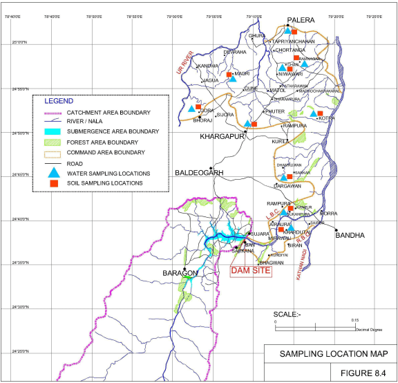
CIFRI-NIH’s flawed assessment of Teesta IV HEP e-flows Teesta IV HEP proposed in Sikkim is presently under the scanner since many groups have raised the genuine concern with the MoEF (Ministry of Environment and Forests), EAC (Expert Appraisal Committee), FAC (Forest Advisory Committee) and the NBWL (National Board of Wild Life) that if implemented it would mean the death of the last free flowing stretch of the main Teesta river. The ToR (Terms of Reference) of the study commissioned by MoEF says, “An estimation to be made for environmental flows downstream for sustenance of aquatic environment and for downstream uses, considering details of streams joining the river below the proposed dam site with their approximate distance from the dam site, their nature (whether perennial or seasonal) etc. A detailed environmental flows study shall be carried out through the premier institutions such as Central Inland Fisheries Research Institute (CIFRI), Barrackpore and National Institute of Hydrology (NIH), Roorkee for biological and hydrological components”.


The consultants took just 7.5 km length of the river from dam axis to the existing downstream project Teesta V which is immediately downstream. The study carried out in 2009- 2010 period has prescribed a minimum discharge of 10 cumecs (Cubic Meters per second) from the dam during the lean period and 40 cumecs for wet season for aquatic life is also prescribed. The ToR has two objectives namely e flows for the sustenance of aquatic environment and for downstream uses, but the sampling parameters in the presentation does not reflect the fulfillment of these objectives.

Teesta V HEP Photo: Tehelka

Since the Teesta V is already commissioned, the impact below the dammed and flow regulated stretch of Teesta V on the aquatic environment and downstream uses would have given useful comparisons. The study seems to have ignored the e flows for downstream uses of communities even in the 7.5 km stretch. The study though claimed to have used the BBM methodology, it is doubtful if all the relevant building blocks have been considered. The study carried out in 2009-10 does not seem to be uploaded in public domain to date.

E-flows for all projects do not make sense? Most shockingly, the chief consultant for the Ganga River Basin Management Plan now being formulated by a consortium of IITs (Indian Institutes of Technology) Dr Vinod Tare was of the opinion that all projects to release e flows does not make sense. He said it is important to seek balance and generate power as well. Now this is problematic. Let us face it that in Indian conditions we are working on e-flows under data and information deficient conditions. We are still far away from understanding a river system in its complexity along with its basin characters, eco- hydrological interactions and land use changes.

Lack of Eco-hydrological understanding Even NIH engineers and other experts agreed during discussions that we lack reliable hydrological data and have absolutely very little ecological data base on our rivers to arrive at proper recommendations for e-flows. MoEF and NGRBA (National Ganga River Basin Authority) has meanwhile accepted BBM methodology (as in the NGRBA Report; Code – 022_GBP_IIT_EFL_SOA_01_Ver 1_Dec 2011) as the most robust assessment approach to e-flows and they also say it needs to be worked upon.

The report says, ‘The BBM methodology is found to be robust with high confidence level. However, specific flow recommendations are difficult to justify at this stage, and will have to be worked out afresh. The major uncertainties centered on the hydrological and hydraulic models due to lack of availability of reliable data’. In BBM all blocks are equally important as they interact with each other. Against such a scenario, Dr Tare needs to think twice before making such statements! They can be used by dam developers to lobby for reduced or even no flows.

What about e-flows from existing dams? Another missing element from e-flows at the NIH workshop that is bothersome was the lack of interest by the experts and the various authorized institutions in allocating e flows below already dammed rivers. They say it will be a tough job and would not be possible politically. However, ultimately e-flows is a social and political choice with trade offs and negotiations inbuilt into it. Does that imply that we can leave heavily dam ravaged rivers like the Mahanadi, Krishna, Cauvery, Narmada, Tapi, Sabarmati, Godavari, Teesta, Sutlej, Ravi, Beas, Chenab, Periyar and the like to die without allowing them at least their long overdue minimum flows leave alone e flows ? It is high time the Government took interest and started engagement and studies in arriving at and allocating e flows below dammed rivers.

The same Baspa, bone dry, about 5 kms downstream Baspa Dam. Photo: SANDRP Partners

Future challenges After two days of debate and disagreements, I came out of the workshop with the following thoughts at the top of my mind.

Several institutions in this country with expertise in ecology and hydrology and with necessary infrastructure who could have made efforts to put in place comprehensive e-flows assessment process are working for dam developers and serving as experts in EIA studies giving green signals to ill conceived hydro electric projects and dams based on inadequate e-flows recommendations. The level of dilution of science and ethics this can lead to is mind-boggling and with disastrous consequences for our rivers. For example e-flows and minimum environmental flows are being used as synonyms by many institutions including CWC. An interesting and dangerous recommendation from CWC at the workshop is; ‘If feasible, a separate storage of water in the upper reaches of a river basin maybe created for environmental needs which will help in augmenting flows during lean season and satisfy the e-flows demands particularly for Himalayan rivers’. So in future all river basins with dam cascades could be recommended with e-flows reservoirs!

What about compliance, MoEF? While e-flows have become mandatory for hydro power projects in this country, it is surprising and shocking that MoEF is yet to ensure compliance and to take up comprehensive and fundamental assessment of e-flows in sample river basins on its own which is its primary mandate. It is high time MoEF develops a ToR for e-flows from its conception to implementation to monitoring. E-flows assessment presently being carried out lacks proper objectives and mostly excludes communities from its purview or assessment. There is vagueness about what constitutes downstream in e-flows assessment. Even for the e flows assessment carried out in River Ganga for the NGRBA has there been any effort to implement the same? Has the MoEF ever tried to seek inputs on e flows from outside the government organisations or from the several groups working tirelessly for conservation of rivers?

Will NIH exercise have credibility? NIH in collaboration with many institutions proposes to take up sample river basins in India and put in place eco hydrological models for e flows. The absence of MoEF and members of the Expert Appraisal Committee on River Valley Projects at this workshop organized by a MoWR institution speaks for itself how e-flows will be realized if the mandatory ministry does not take a pro active role.

Some of the gaps and challenges in e flows assessment in Indian context include: lack of reliable data, lack of understanding of eco- hydrological linkages, river aquifer interactions, pollution related aspects (how to quantify and relate to flow releases), e-flow releases for flood plains, lack of resource allocation, lack of valuation of ecosystem services and societal – cultural value of rivers, multiple institutions working against each other’s interests (MoWR vs MoEF), Peaking induced flashiness, scientific and acceptable ways to compute e-flows and lastly but most importantly, effective implementation and monitoring.

Experts from other countries pointed out that rather than numbers it is better to have distribution ranges for e flows under Indian conditions with complex dependencies. They also made an important comment that uncertainty and risk factors never get integrated into our e-flows estimations. In India land use changes are also not accounted in e flows calculations.

We have a very long way to go.

Dr. Latha Anantha (latha.anantha9@gmail.com)

SANDRPs post on NIH Eflows workshop:

 https://sandrp.wordpress.com/2013/09/30/nih-roorkees-workshop-on-eflows-where-is-the-credibility/

Environment Impact Assessment · Expert Appraisal Committee

Shoddy EIA by WAPCOS Tries to Push Unjustifiable Bansujara Irrigation Project in Madhya Pradesh

The EIA of the Bansujara Multipurpose Project (BMP) dated May 2013 by WAPCOS has been submitted for Environment Clearance of the project before the Expert Appraisal Committee on River Valley Projects, in Nov 2013. WAPCOS is known to do very shoddy job of Environment Impact Assessments, this one is no different. In what follows I have given a few instances of wrong facts, contradictory facts, wrong calculations or assumptions, incomplete assessments, instances that shows it is cut and paste job and lack of options assessment by the 564 page EIA document. The conclusion is inescapable that the EAC and MoEF must reject this EIA and recommend black listing and other measures against WAPCOS. The project should be asked to get a fresh EIA done by a credible agency. 

Location Map of Bansujara Irrigation Project

WRONG FACTS The EIA provides several completely wrong facts, here are a few instances:

1. River description On p 1-1 the EIA says: “The Bansujara Dam Project lies in Dhasan sub-basin of Betwa basin, River Betwa is a tributary of Yamuna river, rises in district Bhopal district at an elevation of 472 m. After traversing a length of 365 km, it joins Yamuna river in Uttar Pradesh. The river runs for nearly 240 km in Madhya Pradesh, 54 km along common border of Madhya Pradesh and Uttar Pradesh and 71 Km in Uttar Pradesh state before its confluence with Yamuna river near Hamirpur town in Hamirpur district of Uttar Pradesh.” This is actually the description of River Dhasan and not Betwa! It is exactly same as the description of river Dhasan given on the next page and several other places subsequently.

2. Land required for Canals In Table 2.3 it is stated that canals will require 44 ha land, this is clearly gross under-estimate considering even 49.9 km of main canal.

3. Private land under required for project The SIA says on page 1-2, “About 935.11 ha of culturable area, 57.49 ha of forest land and 4209.118 ha of other land including road, nallah, river, etc. will be affected.” This is blatantly wrong figure. On page 1-3/4 of SIA it is stated: “About 2935.11 ha of revenue/government land and 2894.37 ha of private land is to be acquired.” This again is wrong.

As the MoEF factsheet for the Forest clearance for the project says, “Apart from the 57.495 hectares of forest land proposed to be diverted, the project involves submergence of 287.951 hectares of government land and 4,856.276 hectares of private land.” Thus the suggestion by the SIA that only 935.11 ha of culturable land is going under submergence is clearly wrong since most of the private land is under cultivation in these villages.

4. How many families will be affected The MoEF Factsheet for the project says: “The project involves submergence of 21 villages. 2628 houses, 773 wells, 5082 trees, and 2628 families with population of 13,142 are getting affected due to submergence.” These figures are at variance with the figures mentioned in the EIA. For example, the SIA (p 1-4, repeated on page 4-1) says: “Over all 748 families of 9 Abadi Villages will be affected”. This when the project will be taking away 2628 houses as per the Fact sheet, is clearly gross wrong reporting of figures. Because of use of wrong figures, their R&R plan and R&R costs are also all wrong and gross under estimates. Moreover, now the R&R plan and costs should be as per the new Land Acquisition Act Passed by the Parliament, which has not been done in the EIA-SIA. As per the new Act, land has to be provided to each losing farmer, and this must be followed.

5. Completely impossible figures of crop yields A look at table 4.3 of SIA (repeated in table 7.1 of CADP) shows that the consultants have given crop yields before project (e.g. paddy 7 t/ha, wheat 18 t/ha, groundnut 10 t/ha and gram 10 t/ha) which are much higher than the average of even Punjab crop yields and they are expecting to double that post project! These are clearly impossible figures. This shows that the consultants are plain bluffing and seem to have no clue about possible crop yields and in any case do not seem to have done any surveys, but are only cooking up data. Amazingly, they are claiming that with 211% increase in crop yield, the profits from crops will go up by 318%! All this simply shows the manipulations they are indulging in to show the project is economically viable.

CONTRADICTORY FACTS
1. Main canal length Page 2-2 says main canal length is 90 km, the salient features on next page says Main canal length is 49.9 km.

2. Command area Tehsils and villages Section 10.2 of EIA (and again section 2.7 of the CADP) says: “The Command area of the proposed Bansujara Major Irrigation project lies within the district Tikamgarh in jatur and Baldeogarh tehsil” and than goes on to give details of these tehsils, but the rest of the document (e.g. section 6.1) says: “A total of 124 villages are likely to be benefitted by the project. 80 villages are located in Tehsil Khargapur of district Tikamgarh. About 13 villages are located in tehsil Jatara of district Tikamgarh. The remaining (31) villages are located in tehsil Palera of Chattarpur district.” Chapter 6 in fact provides full list of 124 villages in the command area. The subsequent details of the command area given in chapter 10 thus does not match with what is given say in chapter 6.

Contradicting this, page 1-4 of SIA says: “The Bansujara Multipurpose Project will benefit almost 132 villages in districts Tikamgarh and Chattarpur.” Amazingly, the SIA says Palera tehsil is in Tikamgarh district and not in Chattarpur district and that additional ten villages of Badamalhera tehsil of Chattarpur district will also be in command area!

Number of beneficiary villages in Palera tehsil are given as 31 in page 44 (chapter 6) and 30 on page 141 (chapter 11), with even names differing, e.g. Banne Khurd and Bastaguwan mentioned in chapter 6 are missing in chapter 11, village Bargram mentioned in chapter 11 is missing from the list in chapter 6.

All this is most callous and shocking. This fact alone should be sufficient to REJECT this callous EIA and recommend blacklisting and other punitive measures for WAPCOS as consultant.

3. Command area population Section 10.2.1 of EIA says: “As per 2001 Census the total population of the command area is about 38,000. The male and female population is 20,181 and 17,828”. However a look at the 10.2 that follows this sentence shows that these figures are for Jatara tehsil and not command area. Another sign of callousness.

4. Submergence villages Table 11.3 of EIA gives list of Project affected families, which is at variance with the list given in tables 10.8-10.14. Firstly, chapter 10 tables say that 14 villages of Tikamgarh Tehsil are affected, but table 11.3 lists only 13 villages. More shockingly, tables in chapter 10 say 6 villages of Bada Malhera tehsil of Chhatarpur district are affected, whereas the name of this tehsil given in chapter 11 is Bijawar. All this shows shocking callousness of WAPCOS.

5. Storage Capacity Page 11-10 says: “The storage capacity of Bansujara Reservoir is 539.42 Mm3.” This is clearly wrong, the figures for gross and live storage capacity given in salient features and elsewhere are: 313.1 MCM and 272.789 MCM respectively.

6. Water Availability As per Table 5.8, water availability at the project site from MP catchment (2788 sq km) alone is 843 MCM. Strangely, this reduces to 588.68 MCM in table 11.6 for whole of catchment (3331.776 sq km) at dam site. No explanation is given for these figures.

7. Submergence area While most of the document gives submergence area as 5201.71 ha. However, in section 2.7 of EMP, it says, “The submergence area of Bansujara Irrigation Project is 7476 ha.” This is amazing kind of contradiction.

WRONG CALCULATIONS/ ASSUMPTIONS
1. Field channel length grossly underestimated The p 6-6 of EIA says: “The Bansujara Dam Project envisages irrigation over a CCA of 54000 ha. In the areas where irrigation is proposed no field drainage, land shaping of field channels exist and used to be constructed. From general experience and existing practice, it is assessed that a length of 1600 m of field channels will be required to serve a chak of 40 ha of CCA. On this basis, an approximate network of total length of 180 km of field channels will be required for 50% of CCA proposed for irrigation.” Simple calculation suggests that the field channel length for 50% of CCA would be 1080 km (54000 ha / 40 ha per 1.6 km divided by 2 for 50% CCA).

2. Drainage requirement under estimated Section 6.9 (p 6-7) of EIA says, “The command area is being traversed by a large number of nallahs and drains, therefore field drainage should not pose any problem.” This is clearly wrong assumption since additional irrigation will certainly require additional drainage and cost calculations based on such flawed assumptions are bound to be wrong.

3.  Baseless assumption about waterlogging Similarly about the assumption in section 6.13 (p 6-8): “Even after construction of Bansujara Dam Project the area will not face any waterlogging problem.”

4. Wrong claims about no floods The conclusion about flood and back water impacts is completely unfounded in section 6.14 (p 6-8): “As per information gathered from the Collectorate Tikamgarh there is no village affected due to back-water of Dhasan and Ur rivers. The existing drainage system in the command is adequate. The statistics gathered from collectorate Tikamgarh show that there is no flood affected area. The command has fairly good flood disposal capacity and not special measures are called for.” This when the Maximum water level of the dam is full 1.4 m above the FRL, the back water level is found to be high. This is also particularly relevant in flood prone basin like Betwa-Dhasan.

5. Drainage characteristics of clayey soils ignored The assumption in section 7.1 (p 7-1) shows complete lack of understanding on the part of EIA consultants: “The area is sloping gently and near its outfall into Betwa river, the slope is of the order of 0% to 3%. It is traversed by small drainage channels at short distances and they help in draining excess water efficiently. Hence, no provision for drainage has been made. The soil is generally clayey.” It is well known that clayey soils are inefficiently draining soils and to make such assumption for clayey soils is clearly wrong.

6. Unrealistic assumption of irrigation efficiency System irrigation efficiency of 54% assumed in Table 11.10 is clearly wrong, no project in India has achieved such high efficiency. The water loss will surely be much higher than the assumption of 105 MCM on page 11-14. The conclusion on that page that: “The quantum of water not being utilized is quite small and is not expected to cause any significant problem of waterlogging” is clearly wrong and baseless, since water logging also depends on many other factors including drainage, soil structure, underground geology, among other factors.

7. No industries, but 19.4 MCM for industries! The CADP (page 5-7) clearly states: “At present there is no industrial requirement in the area.” And yet the project allocates 19.4 MCM water for industries. This again shows that the project is being pushed even though there is no need for it.

INCOMPLETE ASSESSMENT
1. Dependence on fisheries incomplete It is not clear what is the area from which fisheries assessment done as reported in section 9.11.6. How many people depend on fish, what is the production market and economy of the same is also not reported.

2. Hydrology figures without basis Chapter 11 (Table 11.6) assumes that “For use on u/s of Bansujara dam for environmental and ecological balance and Misc. uses by surface water” is 10 MCM and “Quantity of water reserve for d/s release for environmental and ecological balance” is 15.18 MCM and that groundwater available upstream of dam site will be 58.86 MCM (10% of surface water). No basis is given for any of these and all these (and many other) figures given in the water balance are clearly ad hoc, unfounded assumptions. The groundwater availability is typically 40% of total water availability, so around 67% of surface water availability. Why should it be 10% in case of the Dhasan basin is not explained and in any case does not seem plausible.

However, in Table 2.2 of EMP, the environment flow suggested in monsoon months is 12.8 cumecs. This would mean that the project would need to release 132 MCM of water in four monsoon months as environment flows, when they have assumed in hydrology that only 15.18 MCM water is required for this!

3. Incomplete SIA SIA says (SIA page 1-7) that it has selected certain of the 21 villages facing submergence due to the project. Actually the SIA should have done full survey of all the villages not a sample of villages.

4. Impact of loss of river not assessed It is expected that the SIA will assess the impact of loss of river for the people in submergence and downstream zone, but no such assessment has been done. Even in section 4.4 of SIA on “Impacts of Socio-Cultural Environment”, there is no mention of impact of river (or forest or other natural resources) on the people.

5. Full Canal details not given The EIA or CADP report does not provide the full lengths of main canals, distributaries, minors, field channels and field drains, including their width, land requirements, protection measures like canal like plantations etc. Without these basic details, the EIA or the CADP cannot be considered complete.

6. Command area coinciding with command area of Ken Betwa Link canal and other such projects? A perusal of the Command area of the Ken Betwa River Link Project (TOR approved by EAC in its 45th meeting in Dec 2010) shows that all the three Tehsils (namely Baldeogarh or Khargapur in Tikamgarh district, Jatara Tehsil in Tikamgarh district and Palera Tehsil in Chhattapur district) are also benefiting from Ken Betwa Link Canal. A look at the map of the command area of Ken Betwa link canal and that of the Bansujara shows that some area are certainly common. The EIA of Bansujara should have pointed this out and also if the proposed command area is to benefit from any other such projects, but it has not done that.

CUT AND PASTE JOB? Several parts of EIA raises the suspicion that they are cut and paste from other documents. This suspicion is proved correct when we see this sentence in Table 12.2 in Disaster Management Plan (Chapter 12 of EMP): “All staff from dam site, power house & TRC outlets alerted to move to safer places”, since the Bansujara project has no power house or TRC (Tail Race Channel). The consultants forgot to remove these irrelevant aspects while doing the cut and past job[1], it seems. This is just by way of illustration.

Similarly, the title of the section 2.6 of the Command Area Development Plan says it all: “2.6 FOREST TYPES IN THE MOHANPURA PROJECT AREA”. Here again it is clear that while doing cut and paste from another EIA, the consultants forgot to change the details! There is also the sentence “Tehsil Shajapur has maximum population density of 238 persons per sq.km. (2001 Census data)” on page 2-6 of CADP, but there is no mention of any such Tehsil in the area!

NO OPTIONS ASSESSMENT The EIA does not contain any options assessment. In fact section 10.2.4 shows that 19174 ha of the 48157 ha of cropped area in the command is already irrigated. This means a substantial 40% of the command area is already irrigated.

On page 3-5 of SIA it is mentioned that out of 318 land holding respondents in the SIA survey (in submergence villages), only 4 had unirrigated land. This shows that land of over 99% of respondents is already irrigated.

Very shockingly, the report does not mention what are the levels and trends of groundwater in the catchment and command of the project. When Groundwater is India’s mainstay for all water requirements, not give this full picture of groundwater makes the report fundamentally incomplete.

The area has average rainfall of around 1100 mm and thus more area can get irrigated with better use of this rainfall and such a huge dam with such huge submergence (5202 ha) and land requirement (5887 ha, gross underestimate considering that land for canals are not properly assessed), over 25000 people displacement (at least and that too only from submergence area) and other impacts is not the best option.

CONCLUSION What is listed above is not an exhaustive list. Nor are these some typographical errors, but these show serious incompetence, callousness and worse. The conclusion is inescapable that the EAC and MoEF must reject this EIA and recommend black listing and other measures against WAPCOS. The project should be asked to get a fresh EIA done by a credible agency. The EAC in the past have failed to apply its mind about such shoddy EIAs even when this was shown to EAC through such submissions. Most recent such case is that of the Mohanpura Irrigation Project in MP, in which case too the EIA was done by WAPCOS. It is hoped that EAC will apply its mind to this issue and make appropriate recommendations.


Himanshu Thakkar (ht.sandrp@gmail.com)


[1] Seems like this has been cut and paste from the EMP for the Kangtangshri HEP in Arunchal Pradesh also done by WAPCOS, see: http://apspcb.org.in/pdf/23072013/EMP%20Report-Kangtangshiri.pdf