Climate Change · Dam floods · Floods · Hydropower · Nepal

Himalayan Floods Are Not Just a Water Event, They Are a Debris Event

As I write this, over 1,200 people are dead across Nepal and China, and nearly 5500 more are missing. About 900 people are trapped in hydropower tunnels clogged by debris. Herculean national and international efforts are being made to bring them out, but the tunnel entrances are sealed by dense plugs of compressed sediment, and rescuers have no idea of the extent of that blockage. An Australian tunnel expert summed up, “we might only have to dig 10 meters, or we might have to dig 100 meters.” [1]

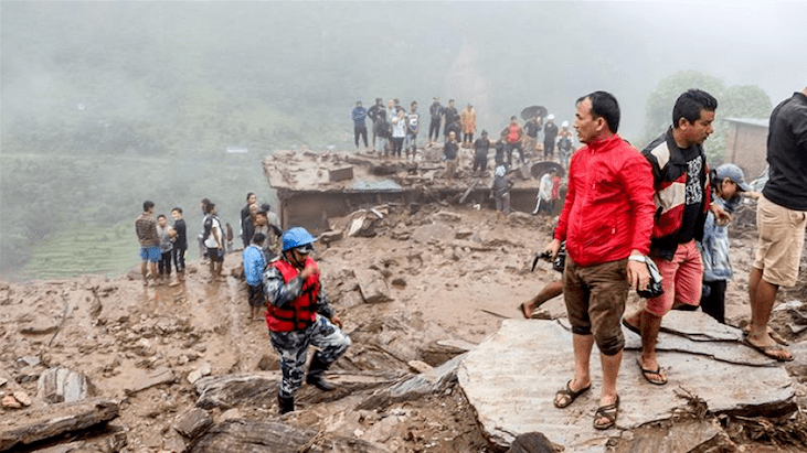
The towns too are buried in silt and debris, compacting like concrete as days go by.

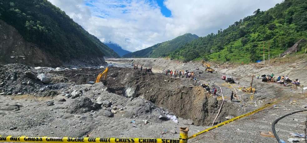
Water flowed off the valley. But the debris, boulders and silt mostly stayed.

Town filled with sediment, Nepal Photo: With thanks from Wall Street Journal

The August 2026 disaster in Nepal is a moment of reckoning.

This is also the moment when we accept Himalayan Floods for what they fundamentally are: not only a meteorological water event, but majorly a geomorphological debris event, conveyed by water.

Even as our flood defenses, settlement planning, DPRs, EIAs, CIAs, GLOF Studies of hydropower projects and the projects themselves consider flood as a water event, what happened in Nepal was a high-velocity mass of rocks, ice, water and mud set in motion by an avalanche. In past Himalayan disasters too, this was clear; it was the boulders the size of houses and blankets of sediment 100 meters deep that destroyed towns, hydropower projects, infrastructure and thousands of lives.

Are our towns, villages, and hydropower projects & infrastructure equipped to face this mountain of debris?

The Trishuli River and the Tunnel Trap

As the flood wave triggered by a rock and ice avalanche roared through the narrow gorges of Lhende Khola, meeting Kyoring and tearing down the Bhote Koshi or Trishuli river, in the way of the river was a cascade of about 15 hydropower plants, which lie mangled and destroyed now. All of these were so-called run-of-the-river hydropower projects which blocked the river with a dam, diverted its water inside the mountain through a tunnel (the headrace tunnel) and brought it down to the powerhouse kilometers downstream. The headrace tunnel of the Rasuwagadhi project is 4.1 km, that of Trishuli 1 project is nearly 10 km [2], and the Trishuli 3A is about 4.1 km [3], while Trishuli 3B is nearly 4 km long. In addition to this, there are penstocks, tailrace tunnels and underground powerhouse access tunnels. For a river with such bumper-to-bumper hydropower dams, the mountainside and riverbank form a maze of tunnels, all of which are clogged with debris, silt, and boulders right now.

Several Himalayan mountainsides in India, Nepal, China and Bhutan are such maze of tunnels today and many have gotten clogged with debris, killing the workers inside.

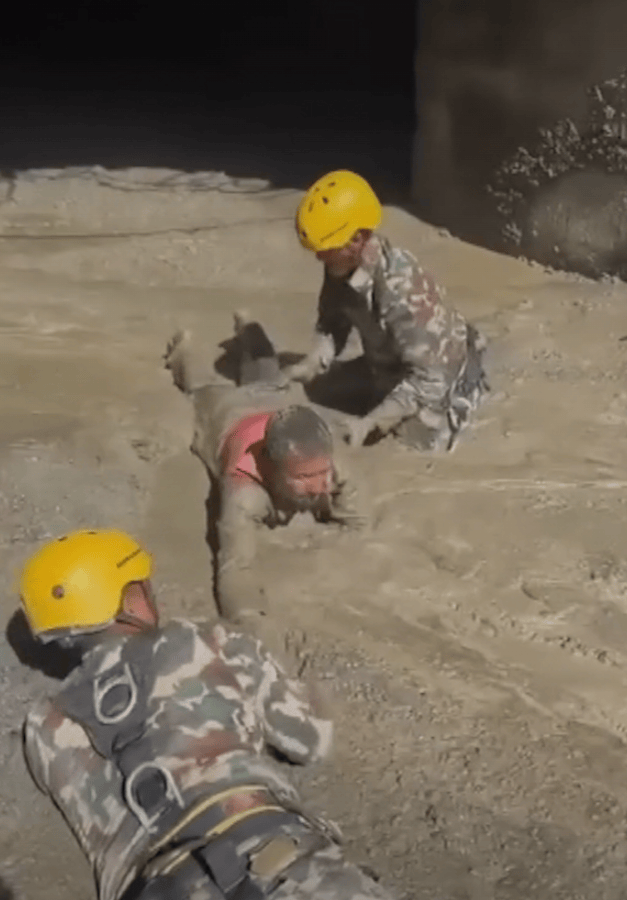
Hydropower Tunnel in Nepal full of silt Photo with thanks from The Independent

And now, nearly 900 people are stuck in Nepal’s tunnels for more than 8 days.

Water has flowed off. Debris has stayed, blocking 80-90% of these tunnels.

Himalayas as the world’s largest Debris Conveyer Belt

Conveying enormous volume of debris is the fundamental nature of Himalayan flood disasters.

As the earth’s youngest mountain range, unlike the older Alps or the drier Andes, the Himalayas act as a relentless sediment conveyor belt. Constant tectonic uplift, extreme monsoon rains, receding glaciers exposing glacial moraine, and melting permafrost all compound into creating massive amounts of sediment. The Himalayas experience some of the highest sediment yield and denudation rates globally, making Himalayan watersheds the most sediment-rich river systems in the world (Ghimire et al., 2024; Klemme et al., 2024).

In a natural setting, floods are great engines to move sediment from mountains to the river and to the delta. In fact, that is one of their important ecological services. Himalayan source regions bring billions of tons of silt to Ganga-Brahmaputra delta, making it the largest delta in the world[1]. But when this process is exacerbated by climate change and erratic weather patterns and when thousands of humans are concentrated in valleys close to hanging glaciers or filled with glacial moraine to build dams, colonies, and towns, a natural phenomenon turns into a human disaster of colossal proportions.

This is illustrated by the brief list of recent disasters in Himalayas, causing disturbing human tragedies.

Recent Disasters in the Himalayas

Graph by SANDRP based on various publications. Made with the help of Google LLM

• Rishiganga Ice-Rock Avalanche and Tapovan Vishnugad HEP (2021): A rock and ice avalanche remarkably similar to the one in Nepal completely pulverized the 13.2 MW Rishiganga HEP and destroyed the Tapovan Vishnugad Project, killing over 200 people.

Shugar et al. [4] write, “Nearly all (190) of the 204 people either killed or missing in the disaster were workers at the Rishiganga (13.2 MW) and Tapovan (520 MW) project sites… The high loss of human life and infrastructure damage was due to the debris flow, and not the initial rock and ice avalanche. The Chamoli event may be seen in the context of a change in geomorphological sensitivity and might therefore serve as a precursor for an increase in such events as climate warming proceeds.”

Debris deposition and Destruction at Rishiganga Hydropower Project With thanks from Pandey et al, 2021

• Sikkim GLOF and Teesta 3 HEP (2023): The glacial lake outburst that destroyed Sikkim’s 1200 MW Teesta 3 in Oct 2023 carried massive amounts of glacial debris that acted like a battering ram. Dr. Ashim Sattar, who warned about the disaster potential South Lhonak Lake before the GLOF, also calculated the sheer volume of sediment [5] collected by the water on its way to the Teesta 3 dam: “The sheer volume of water (50 Million Cubic Meters) released from the lake, together with the sediment (270 Million Cubic Meters) entrained along the valley, drove the primary impacts that overwhelmed infrastructure and developmental activities along the Teesta River, exacerbating the human and economic toll.”

Debris deposition and destruction at Teesta III Dam Photo with thanks from Arunima Kar/ Al Jazeera

• Dharali (2025): Resulting in 64 deaths and 81 missing persons, persistent rainfall triggered a debris flow on the moraine slope at the foot of the Shrikanth glacier, mobilizing large volumes of unconsolidated moraine and colluvial sediments. The high-energy flow buried parts of Dharali under 12–18 meters of debris weighing roughly 251,000 tons, destroyed nearly 60% of its infrastructure, and caused the partial damming of the Bhagirathi River [6].

Sediment disposition at Dharali photo: ISRO

Debris at Dharali Photo: Rediff

• Chasoti (2025): Entire settlements were buried under 50 to 60 feet of rock, boulders, and mud, killing 93 people [7].

J&K flash floods: At least 60 dead, over 100 injured on Machail Mata  pilgrimage route after cloudburst | India News

Debris at Chasoti following floods Photo: with thanks from Hindustan Times

• The 2013 Uttarakhand (Kedarnath/Mandakini-Alaknanda) Floods: Multi-institutional geomorphic studies, including work by the Wadia Institute of Himalayan Geology and international teams analyzing the June 2013 disaster, documented that while the breach of Chorabari Lake released roughly 0.61 million cubic meters of water, catastrophic mass wasting across the basin resulted in huge amounts of debris. In the upper Kedarnath valley alone, an estimated 3.9 million cubic meters of debris was deposited locally, and basin-wide sediment calculations across affected reaches registered tens of millions to hundreds of millions of cubic meters of bedload and valley-fill material being stripped and aggressively transported downstream.

This massive sediment wave choked riverbeds, raised channel floors by several meters, and battered cascading hydro projects like Srinagar, Singoli-Bhatwari and Phata Byung. Hydropower Projects Vishnuprayag got jammed with boulders, forcing the river to swerve into its left bank, destroying Roads, settlements and killing people.

Vishnuprayag Project buried in sediment Photo: Matu Jan Sangathan

Can the Bumper-to-Bumper Hydropower Projects Respond to This Debris Transfer?

Along with roads, tourism facilities, townships and other infrastructure, hydropower projects are the most serious stressors of Himalayas.

They not only dam and obstruct rivers, they involve submerged areas, deforestation, blasting, mining and tunneling, water level fluctuations, associated roads and transmission lines on unstable slopes and huge amounts of muck that is commonly deposited inside the riverbed.

Himalayan river valleys across India, Nepal, Bhutan, Tibet are tethered in chains of hydropower projects commissioned, under construction and planned. Studies estimate that if current dam building rates continue (which may even be accelerated), Indian Himalayas may be most dam dense valleys in the world, a dam density 62 times greater than the global averages. [2]

Himalayan Glacial Lakes and Hydropower Projects In their shadow. With thanks from Schwanghart et al, 2016[3]

So, if a Himalayan flood is not just water but more of a debris flow of stone, mud, trees and house-sized boulders, and if the rivers are tethered under dam cascades, how are the hydropower projects equipped to deal with this colossal debris?

They are not.

In fact, the ‘bumper-to-bumper’ cascade model of Himalayan dams weaponizes this sediment.

Water exerts hydrostatic pressure, which the dams are designed to resist. However, a debris flow acts as a severe force multiplier. Millions of tons of solid mass strike the concrete with the kinetic energy of Thor’s hammer. When an upstream dam fails, its shattered concrete, trapped reservoir sediment, and millions of tons of muck generated by blasting and tunneling are added to the debris flow, exponentially increasing the destructive mass that slams into the river and the next project downstream.

Is Sediment Considered When Dams Receive Clearances?

The true impact of sediment is systematically and shockingly ignored in current hydropower planning. Debris Flow is a blind spot in Himalayan Dam Planning.

DPRs, Environmental Impact Assessments (EIAs), Cumulative Impact Assessments, and hydrological safety models deal mainly with water, not debris flow.

They calculate the Probable Maximum Flood (PMF) in cubic meters per second of clear water and design projects able to withstand or deal with it. They design spillways to pass water, not debris flow or boulders. When they calculate yield of a catchment, they deal with rainfall and runoff.

Not debris.

When engineers and policymakers do consider ‘silt,’ they view it purely through an operational lens as a nuisance that degrades turbine blades or slowly reduces the live storage capacity of a reservoir over decades to be managed by flushing and desilting chambers.

Sediment and debris flow is not assessed as the dynamic, structural threat during extreme weather events. We do not have calculations, or an earnest attempt at them, to understand the volume of a debris flow that can be generated by a catastrophic flood, GLOF, or landslide. And these are not occasional events, they have become painfully common in the Himalayas.

Until our environmental and engineering frameworks shift from a meteorological paradigm (water) to a geomorphological one (mass movement of debris), we will continue building fragile infrastructure directly in the path of destruction, compounding disasters and putting the lives of thousands of hydropower workers and downstream populations at risk.

A look at the table here clarifies this further. In all these projects, some cleared, some under construction, and some commissioned, the EIAs and CIAs considered only “water” when designing for floods. They did not factor in GLOFs, the compounding effects of debris flows, sediments and glacial moraine, how to pass them, or what the frequency of these events might be.

The Teesta 3 dam, which was destroyed by the South Lhonak GLOF, was given environmental clearance again at the very same spot, even as the lake remains dangerous today. It used the same flawed EIA that was at the root of disaster, since it ignored the GLOF risk. Only change was the strength of the dam wall and the spillway capacity to pass more water, which legally should have meant fresh EIA-EMP. When the debris flow in 2023 consisted of five times as much sediment as water.

The Tapovan Vishnugad project, which lies downstream an extremely risky glacial location, was allowed to be reconstructed even as workers died there.

Hydropower projects in the Kishtwar and Ramban regions of Jammu, and the Pangi and Miyar valleys of Himachal, received clearances in narrow valleys, despite having active, highly destructive glacial lakes sitting directly above them.

Where is the accountability if these lakes burst, or if a cloudburst like Chasoti occurs, or if permafrost melting like Lahaul causes catastrophic landslides, and these dams, which are completely unequipped to deal with boulders, debris flows, and sediment bursts, fail?

Where does the accountability lie?

Limits to Engineering Safety

Hydropower cascades in the Himalayas cannot simply be engineered to safety under the current paradigm. Standard engineering interventions, such as wider spillways or reinforced barrages, are designed to manage extreme water volumes and primarily to protect the dams, not people.

They are structurally incapable of surviving the kinetic impact of hyper-concentrated mass movements.

The ‘bumper-to-bumper’ cascade design creates a disaster zone of a river.

Like we saw in case of Vishnuprayag Dam, when a high-altitude debris flow hits an upstream dam, it does not just overtop it, it either blocks it completely, diverting the river, or shatters it. As we saw in Sikkim when the South Lhonak lake outburst pulverized the Teesta III dam, the flood absorbed the broken concrete and the massive volume of sediment trapped in the reservoir. This newly bulked-up mass then accelerated downstream, slamming into the next project in the cascade with exponentially greater destructive force.

Current engineering is not ready to fix this domino effect of dam cascades: the cascade model itself is the hazard.

Neither is the current governance ready to appreciate the impact of debris flow and sediment in its clearance process.

What Can Be Done?

Hydropower in the Himalayas, especially cascades of dams, need to be fundamentally reassessed.

A Climate Risk Assessment with the active participation of local communities and independent experts is urgently needed for all Himalayan dam cascades.

If anyone doubts what local communities can contribute to this scientific discussion, let us be reminded of the Public Hearing for the Teesta 3 project. At that Hearing, it was a community member, Pemzang Tenzing, who expressed his concern that, “The retreating glaciers are altering the hydrological regime in the Himalayan region and also pose environmental risks such as Glacial Lake Outburst Floods (GLOFs) and increased sedimentation.”

The answer he was given was that “Most of the aspects have been comprehensively covered.” Furthermore, the EIA consultant WAPCOS stated, “For this dam, several dam safety surveillance systems have been suggested to ensure that the dam never fails even under most adverse conditions” [8].

The dam failed, killing more than 100 people.

WAPCOS’ claim about dam safety surveillance systems were not set up. No one was held accountable for any of the lapses. Even NGT and High Court dismissed petitions filed by local people on these aspects.

Immediate Steps:

• Establish Geomorphic ‘No-Go’ Zones: Until a fundamentally different framework for Himalayan hydropower which considers impacts of sediment is conceptualized, discussed, agreed upon, and put in place through an independent mechanism, creating No-Go zones for hydropower projects seems like the only logical first step.

We understand the claims that hydropower projects provide employment, bring money local and national economies and that there is a huge private and public investment gone into building of these dams, however, looking at the recent deaths of hydropower workers (more than 300 in India in the past fiver years and hundreds or thousands in Nepal) and the amount of investment lost in destroyed projects, these are minimum steps necessary.

Paraglacial Elevation Zones:

Following the 2013 Kedarnath disaster, the Ravi Chopra Committee explicitly recommended halting hydropower development in paraglacial valleys above 2,000 meters in Uttarakhand. Infrastructure in these high-altitude zones gives little to no reaction time after rock-ice avalanches or glacial lake outbursts.

Dam projects are built directly beneath hanging glaciers and unstable moraines, as illustrated starkly by Dhauliganga projects like Rishiganga and Tapovan Vishnugad. When a slope fails, workers have no warning time before debris hits, which is also why hundreds of people remain trapped in the Trishuli headrace tunnels.

A recent study shows that Alaknanda valley alone has 219 hanging glaciers and the extent of hanging mass area is 33.1 sq. kms[4]. The basin represents ~50% of the state’s total unstable hanging mass volume. The same valley is littered with hydropower projects which have faced disasters and are under construction.

Imagine the debris damage potential of these hanging glaciers.

Car-sized boulders in the bedload that wrecked the 5 MW Motigad HEP by UJVNL during the flood of 2013, on a small tributary of the Gori river. Photo Emmanuel Theophilus

If the uppermost dam were situated much further downstream, the physical distance would act as an early warning buffer, giving downstream projects crucial lead time to evacuate personnel, fully open barrage gates, and let floods pass.

• Active Tectonic Corridors: Valleys intersecting the Main Central Thrust (MCT) and Main Boundary Thrust (MBT) undergo constant seismic crushing, guaranteeing a continuous supply of loose, easily mobilized landslide debris. A massive number of hydropower projects are currently concentrated directly within these zones in Jammu, Uttarakhand, and Sikkim.

• Free-Flowing Main Stems: Within every major basin, the main stem or a primary tributary must remain undammed to act as a hydrological safety valve and ecological corridor.

Undertake studies to understand volume of debris flow that can be generated in a catchment above a hydropower cascade or a town. Discuss these studies with local communities and experts. How can dam cascades be cleared without this?

If we continue to ignore the geomorphological reality of the Himalayas, the cascading infrastructure we build will continue to serve as an instrument of downstream destruction.

Somewhere beneath the sediment in the Trishuli valley right now, that reality is waiting to be dug out: ten meters down, or a hundred.

Parineeta Dandekar, SANDRP, with inputs from Himanshu Thakkar

parineeta.dandekar@gmail.com, ht.sandrp@gmail.com

References

1. CNN. (2026, August 30). Nepal workers trapped in flooded hydro tunnel. https://edition.cnn.com/2026/08/30/asia/nepal-workers-flooded-hydro-tunnel-intl

2. Andritz. Upper Trishuli-1, Nepal. https://www.andritz.com/hydro-en/hydronews/hn36/upper-trishuli-1-nepal

3. NWRMAP. Upper Trishuli-3A. https://nwrmap.pei.center/hydropower/upper-trishuli-3a

4. Shugar, D. H., et al. (2021). A massive rock and ice avalanche caused the 2021 disaster at Chamoli, Indian Himalaya. Science, 373(6552), 300-305. https://www.science.org/doi/10.1126/science.abh4455

5. Sattar, A., et al. (2023 / University of Lausanne Repository). Glacial lake outburst flood dynamics and sediment entrainment in the Teesta basin. https://api.unil.ch/iris/server/api/core/bitstreams/8e6c0c1e-4ef1-4de4-b5ca-583103b5bfe2/content

6. Kumar, et al. (2026). The Dharali catastrophic disaster of 05th August 2025: A wake-up call from the Kheer Ganga, NW Himalaya. Natural Hazards Research, 6, 494–502.

7. Kashmir Life. (2025). A year on, 30 Chasoti cloudburst victims remain missing as families await closure. https://kashmirlife.net/a-year-on-30-chasoti-cloudburst-victims-remain-missing-as-families-await-closure-447915/

8. Sanctuary Nature Foundation. Teesta flood and dam disaster: Hydropower and environmental misgovernance. https://www.sanctuarynaturefoundation.org/article/teesta-flood-and-dam-disaster-hydropower-and-environmental-misgovernance


[1] https://online.ucpress.edu/elementa/article/doi/10.1525/elementa.250/112454/Doomed-to-drown-Sediment-dynamics-in-the-human

[2] https://conbio.onlinelibrary.wiley.com/doi/abs/10.1111/j.1523-1739.2012.01918.x

[3] Wolfgang Schwanghart et al 2016 Environ. Res. Lett. 11 074005

[4] https://www.researchgate.net/profile/Nandu-Krishnan-7/publication/404030339_Assessment_of_Avalanche_Hazard_from_Hanging_Glaciers_in_the_Uttarakhand_Himalaya_Regional_Inventory_Dynamic_Flow_Modelling_and_Exposure_Analysis/links/69e767bdb1056332819de892/Assessment-of-Avalanche-Hazard-from-Hanging-Glaciers-in-the-Uttarakhand-Himalaya-Regional-Inventory-Dynamic-Flow-Modelling-and-Exposure-Analysis.pdf

Nepal

DRP NEPAL 2023: Vibrant debate about Hydro Projects

This provides an overview of Dams, Rivers & People related issues in Napel in just concluded 2023. While export of hydropower to India is central this year following Nepal PM’s June 2023 visit to India. Pancheshwar, the most ambitious of the projects have seen no real progress in spite of repeated statements. An agreement signed with India to export upto 10000 MW of hydropower in ten years has raised lot of hopes in both countries. The electricity trade has indeed expanded significantly in 2023. There is also renewed hope for Nepal succeeding in export of hydropower to Bangladesh via India, but this still needs some concrete success.

However, most interesting is the vibrant debate in Nepal media about adverse economics, impact on environment, biodiversity and disasters, in addition to displacement risk for thousands of people. Some called it costly madness. It also notes that climate change does not even figure in decision making process. The overview begins with that debate.

Continue reading “DRP NEPAL 2023: Vibrant debate about Hydro Projects”
Dams, Rivers & People · Nepal

Dams, Rivers & People overview of Nepal 2020

This report provides and overview of key developments in Nepal about Dams, Rivers, Environment and people in 2020, we had provided similar overview in 2019[i] too. We have divided the overview into these sections: Hydropower projects, Power Trade, Governance, River Sand Mining, Monsoon 2020 dominated by Landslide news, Climate Change, India-Nepal issues dominated by Pancheshwar and border dispute issues, Nepal China issues.

Continue reading “Dams, Rivers & People overview of Nepal 2020”