
It is good to see this week that the National Green Tribunal (NGT) has acknowledged the non-existent or vacuous groundwater governance in India at both central and state levels. It was long overdue. It took the judiciary almost three decades to realise this, since the Supreme Court order in late 1990s for setting up Central Ground Water Authority (CGWA) under the 1986 Environment Protection Act.
Continue reading “DRP 040526: NGT acknowledges vacuous Groundwater Governance in India”Tag: Small Hydro
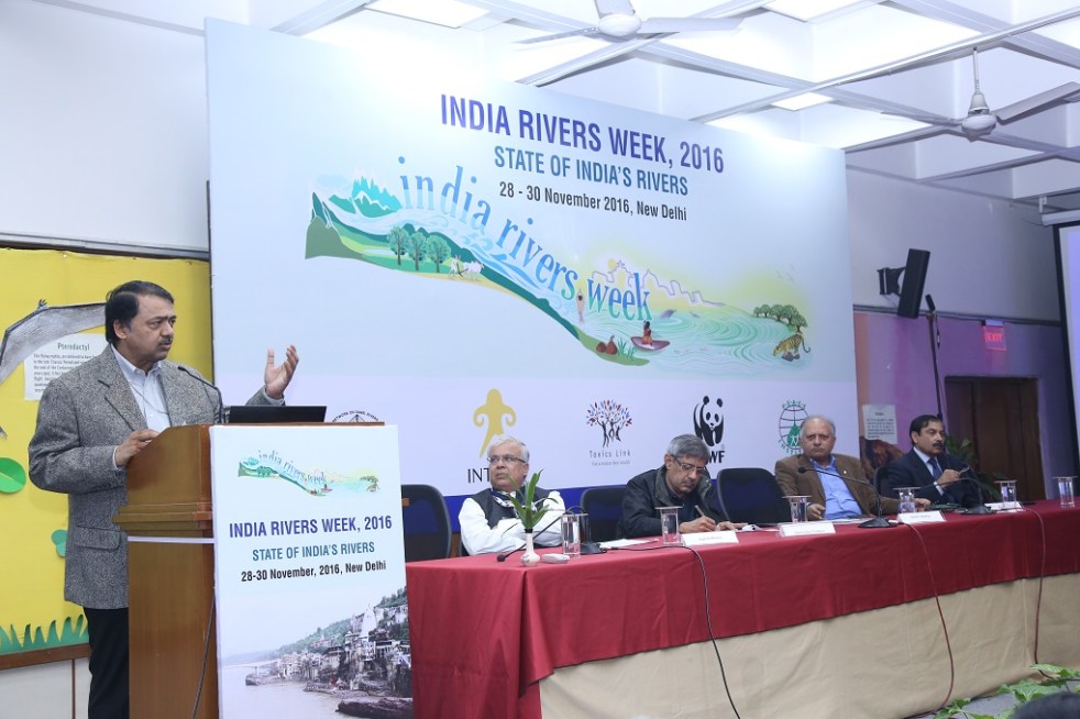
DRP: 12 Dec 2016 (The interest is not in irrigation but in constructing assets- says Water Secretary)
In an interview with The Third Pole, Shashi Shekhar, secretary in the Ministry of Water Resources, River Development and Ganga Rejuvenation discussed the problems and prospects of India’s water sector. A number of issues which SANDRP and several other water experts and environmentalists have been calling attention to for decades were affirmed by the ‘man behind the scene’.
Perhaps most importantly he reiterated what he admitted at India Rivers Week held in Delhi in Last week of November that the ‘politician-bureaucrat-contractor nexus’ was the “biggest bane of India’s water sector”.
Pinpointing to the average gap of about 45% between irrigation potential and actual irrigation he said- “The interest is not in irrigation but in constructing assets because that is where the money is. All the states have sizeable budgets for this. After all that, the total (canal) irrigated area in the country is 10-15%. So why should it get such vast resources? It does so because the contractor is interested, and there are below the table payments. This is the problem.”
Continue reading “DRP: 12 Dec 2016 (The interest is not in irrigation but in constructing assets- says Water Secretary)”
White Elephant, Black Fish
How a 15 MW project with 55 mts high dam threatens 5 villages and a fish sanctuary
After an analysis of a particularly nasty dam, I felt like going back to flowing rivers. It is monsoon after all. The plan was to visit Kal River in Western Ghats of Raigad District in Maharashtra to understand how a community in a small village called Walen Kondh is protecting the river and Mahseer fish. Mahseer (Deccan Mahseer, Tor tor) is classified as endangered as per IUCN classification and most wild Deccan Mahseer populations have been wiped out in India. And hence a small, out of the way place, protecting these fish as well as the river voluntarily was like a breeze of fresh air. Continue reading “White Elephant, Black Fish”
Mission on Small Hydro Projects: Ignoring social and environmental impacts will not help
As Prime Minister Narendra Modi inaugurated the RE-Invest 2015, India’s first Renewable Energy Global Investors’ Meet and Expo in New Delhi on February 15, 2015, full-page advertisements in the National Capital declared the target of adding 5000 MW of small hydro capacity by 2022, in addition to other renewable energy targets. A part of this renewed focus on small hydro, a subset of India’s new push for Renewable Energy, involves a new Mission for Small Hydro Projects. Even as it has some welcome features, the new Mission will not help if the government continues to ignore significant social and environmental impacts of small hydro projects. Continue reading “Mission on Small Hydro Projects: Ignoring social and environmental impacts will not help”

Uttarakhand: Existing, under construction and proposed Hydropower Projects: How do they add to the state’s disaster potential?
As Uttarakhand faced unprecedented flood disaster and as the issue of contribution of hydropower projects in this disaster was debated, questions for which there have been no clear answers were, how many hydropower projects are there in various river basins of Uttarakhand? How many of them are operating hydropower projects, how many are under construction and how many more are planned? How many projects are large (over 25 MW installed capacity), small (1-25 MW) and mini-micro (less than 1 MW installed capacity) in various basins at various stages?
This document tries to give a picture of the status of various hydropower projects in various sub basins in Uttarakhand, giving a break up of projects at various stages, As per available information in July 2013.
River Basins in Uttarakhand Entire Uttarakhand is part of the larger Ganga basin. The Ganga River is a trans-boundary river, shared between India and Bangladesh. The 2,525 kms long river rises in the western Himalayas in the Indian state of Uttarakhand, and flows south and east through the Gangetic Plain of North India into Bangladesh, where it empties into the Bay of Bengal. The Ganga begins at the confluence of the Bhagirathi and Alaknanda rivers and forms what we have called Ganga sub basin till it exits Uttarakhand. Besides Bhagirathi, Alaknanda and Ganga sub basin, other river basins of Uttarakhand include: Yamuna, Ramganga (Western Ramganga is taken as Ramganga basin in this document, eastern Ramganga is considered part of Sharda basin) and Sharda. Sharda sub basin includes eastern Ramganga, Goriganga, Dhauliganga, Kaliganga and part of Mahakali basin.
Existing hydropower projects in Uttarakhand In the table below we have given the sub basin-wise list of existing hydropower projects in Uttarakhand along with their capacities. The list has been prepared based on various sources including Central Electricity Authority, Uttarakhand Jal Vidhyut Nigam (UJVNL), Uttarakhand Renewable Energy Development Authority (UREDA) and Report of Inter Ministerial Group on Ganga basin.
Existing Hydropower projects in Uttarakhand
| Projects |
Installed Capacity (MW) |
|
Projects in Alaknanda River Basin |
|
| 1. Vishnu Prayag (P) |
400 |
| 2. Tilwara |
0.2 |
| 3. Soneprayag |
0.5 |
| 4. Urgam |
3 |
| 5. Badrinath II |
1.25 |
| 6. Rajwakti (P) |
3.6 |
| 7. Tapowan |
1 |
| 8. Jummagad |
1.2 |
| 9. Birahi Ganga (P) |
7.2 |
| 10. Deval (P Chamoli Hydro P Ltd on Pinder) |
5 |
| 11. Rishiganga (P) |
13.5 |
| 12. Vanala (P Hima Urja P Ltd Banala stream) |
15 |
| 13. Kaliganga I (ADB) |
4 |
| Alaknanda Total |
455.45 |
|
Projects in Bhagirathi River Basin |
|
| 14. Maneri Bhali-1 (Tiloth) |
90 |
| 15. Maneri Bahli-2 |
304 |
| 16. Tehri St-I |
1000 |
| 17. Koteshwar |
400 |
| 18. Harsil |
0.2 |
| 19. Pilangad |
2.25 |
| 20. Agunda Thati (P Gunsola hydro Balganga river) |
3 |
| 21. Bhilangana (P – Swasti) |
22.5 |
| 22. Bhilangana III (P – Polyplex) |
24 |
| 23. Hanuman Ganga (P – Regency Aqua) |
4.95 |
| Bhagirathi Total |
1850.9 |
|
Projects in Ganga River sub basin downstream of confluence of Bhagirathi and Alaknanda |
|
| 24. Chilla |
144 |
| 25. Pathri |
20.4 |
| 26. Mohamadpur |
9.3 |
| Ganga sub basin Total |
173.7 |
|
Projects in Ramganga basin |
|
| 27. Ramganga |
198 |
| 28. Surag |
7 |
| 29. Loharkhet (P Parvatiya Power P Ltd Bageshwar) |
4.8 |
| 30. Kotabagh |
0.2 |
| 31. Sapteshwar |
0.3 |
| 32. Gauri |
0.2 |
| Ramganga Total |
210.5 |
|
Projects in Sharda River Basin |
|
| 33. Dhauliganga |
280 |
| 34. Tanakpur |
94.2 |
| 35. Khatima |
41.4 |
| 36. Chirkilla |
1.5 |
| 37. Taleshwar |
0.6 |
| 38. Suringad |
0.8 |
| 39. Relagad |
3 |
| 40. Garaon |
0.3 |
| 41 Charandev |
0.4 |
| 42. Barar |
0.75 |
| 43. Kulagad |
1.2 |
| 44. Kanchauti |
2 |
| Sharda Total |
426.15 |
|
Projects in Yamuna River Basin |
|
| 45. Chibro |
240 |
| 46. Dhakrani |
33.75 |
| 47. Dhalipur |
51 |
| 48. Kulhal |
30 |
| 49. Khodri |
120 |
| 50. Galogi |
3 |
| 51. Tharali |
0.4 |
| Yamuna Total |
478.15 |
| Grand Total |
3594.85 |
Note: (P) in the bracket suggests the project is in private sector, throughout this document. The eastern Ramganga river, which is part of Sharda basin, is included in Sharda basin. Where-ever Ramganga river is mentioned in this document, it refers to Western Ramganga, which is a tributary of Ganga.
In the next table we have given available list of existing mini and micro hydropower projects in Uttarakhand, based on UREDA information.
List of projects up to 1 MW under operation:
| SN | Project |
Ins Cap (MW) |
Dist | Basin |
| 1 | Milkhet |
0.1 |
Chamoli | Alaknanda |
| 2 | Bamiyal |
* |
Chamoli | Alaknanda |
| 3 | Bursol |
0.2 |
Chamoli | Alaknanda |
| 4 | Choting |
0.1 |
Chamoli | Alaknanda |
| 5 | Ghagaria |
0.1 |
Chamoli | Alaknanda |
| 6 | Ghagaria Extension |
* |
Chamoli | Alaknanda |
| 7 | Ghes |
0.1 |
Chamoli | Alaknanda |
| 8 | Gulari |
0.2 |
Chamoli | Alaknanda |
| 9 | Niti |
0.025 |
Chamoli | Alaknanda |
| 10 | Sarma |
0.1 |
Chamoli | Alaknanda Nandakini/ Maini Gad |
| 11 | Wan |
0.05 |
Chamoli | Alaknanda |
| 12 | Bank |
0.10 |
Chamoli | Alaknanda Pinder |
| 13 | Gamsali Bampa |
0.05 |
Chamoli | Alaknanda Dhauliganga/Ganesh Ganga |
| 14 | Kedarnath II |
0.2 |
Rudraprayag | Alaknanda |
| 15 | Badiyakot |
0.1 |
Bageshwar | Alaknanda |
| 16 | Kunwari |
0.05 |
Bageshwar | Alaknanda |
| 17 | Borbalada |
0.025 |
Bageshwar | Alaknanda Pindar/ Chhiyaldi Gad |
| 18 | Dokti |
0.02 |
Bageshwar | Alaknanda |
| 19 | Dior IInd Phase |
* |
Pauri | Alaknanda/ Ganga |
| 20 | Chandrabhaga Gad |
* |
Tehri | Bhagirathi |
| 21 | Jakhana |
0.1 |
Tehri | Bhagirathi Bhilangana/Balganga |
| 22 | Gangotri-I |
0.1 |
UttarKashi | Bhagirathi Kedar Ganga |
| 23 | Kanwashram |
0.1 |
Pauri | Ganga |
| 24 | Bilkot |
0.05 |
Pauri | Ramganga |
| 25 | Dior Ist Phase |
0.1 |
Pauri | Ramganga |
| 26 | Gogina II |
0.05 |
Bageshwar | Ramganga |
| 27 | Sattshwar |
0.05 |
Bageshwar | Ramganga |
| 28 | Toli |
* |
Bageshwar | Ramganga |
| 29 | Ramgarh |
0.1 |
Nainital | Ramganga |
| 30 | Lathi |
0.1 |
Bageshwar | E Ramganga/Sharda |
| 31 | Liti |
0.05 |
Bageshwar | E Ramganga/Sharda |
| 32 | Liti-II |
0.05 |
Bageshwar | E Ramganga/Sharda |
| 33 | Ratmoli |
0.05 |
Bageshwar | E Ramganga/Sharda |
| 34 | Baghar |
0.05 |
Bageshwar | E Ramganga/Sharda |
| 35 | Baicham |
0.1 |
Bageshwar | E Ramganga/Sharda |
| 36 | Jugthana |
0.1 |
Bageshwar | E Ramganga/Sharda |
| 37 | Kanol gad |
0.1 |
Bageshwar | E Ramganga/Sharda |
| 38 | Karmi |
0.05 |
Bageshwar | E Ramganga/Sharda |
| 39 | Karmi -III |
0.05 |
Bageshwar | E Ramganga/Sharda |
| 40 | Karmi-II |
0.05 |
Bageshwar | E Ramganga/Sharda |
| 41 | Bhikuriya Gad |
0.5 |
Pithoragarh | Sharda |
| 42 | Kanchauti |
* |
Pithoragarh | Sharda |
| 43 | Lamabager |
0.20 |
Bageshwar | Sharda Saryu |
| 44 | Lamchula |
0.05 |
Bageshwar | Sharda Saryu |
| 45 | Tarula |
0.10 |
Almora | Sharda Saryu/Jataya Ganga |
| 46 | Taluka |
0.025 |
Uttarkashi | Yamuna Tons/ Gattu Gad |
| 47 | Bhadri Gad |
0.02 |
Tehri | Yamuna |
From http://ahec.org.in/, capacity of some of the projects is as per the UJVNL website. The capacity comes to 3.815 MW for the 41 projects for which capacity is available, for six mini-micro HEPs in Uttarakhand listed above, this information is not available..

Based on above two tables, in the following table we have provided an overview of operating hydropower projects and their capacity, with basin wise and size wise break up.
Uttarakhand has total of 98 existing hydropower projects, with total installed capacity of close to 3600 MW. At least eleven of these projects are in private sector with total capacity of over 503 MW. An additional about 1800 MW capacity is in central sector. It means that majority of the power generation capacity in the state is not owned by the state and there is no guarantee how much of that power would be available to the state.
Basin wise number of operating hydro projects in Uttarakhand
| Basin | Large Hydro projects (above 25 MW) | Small Hydro projects (1-25 MW) | Mini-micro Hydro projects (below 1 MW) | Total Hydro projects | ||||
| No of projects | Capacity, MW | No of Projects | Capacity, MW | No of Projects | Capacity, MW | No of Projects | Capacity, MW | |
| Alaknanda |
1 |
400 |
10 |
54.75 |
21 |
2.22 |
32 |
456.97 |
| Bhagirathi |
4 |
1794 |
5 |
56.7 |
4 |
0.4 |
13 |
1851.1 |
| Ganga Sub basin |
1 |
144 |
2 |
29.7 |
1 |
0.1 |
4 |
173.8 |
| Ramganga |
1 |
198 |
2 |
11.8 |
9 |
1.05 |
12 |
210.85 |
| Sharda |
3 |
415.6 |
4 |
7.7 |
21 |
4.45 |
28 |
427.75 |
| Yamuna |
5 |
474.75 |
1 |
3 |
3 |
0.445 |
9 |
478.195 |
| TOTAL |
15 |
3426.35 |
24 |
163.65 |
59 |
8.665 |
98 |
3598.665 |
Here we should note that as per the Union Ministry of New and Renewable Energy sources, in Uttarakhand, by March 2013, 98 small hydro schemes has been installed with total capacity of 170.82 MW. If we add the small and mini-micro projects in above table, we have 83 operating schemes with installed capacity of 172.315 MW. This mis-match is not possible to resolve since MNRE does not provide full list of operating SHPs in Uttarakhand.
Under Construction Hydropower projects in Uttarakhand In the table below we have given available list of under construction hydropower projects in Uttarakhand. Actual list of under construction projects is likely to be larger than this, since clear and uptodate information is not available on official website. Please note that this does not include the list of mini and micro hydropower projects that are under construction. Even in case of small hydro projects (1-25 MW capacity), the list is not complete. According to this list, 41 projects with 2378.115 MW capacity are under construction in Uttarakhand. 6 of them are large hydropower projects and rest 35 are small or mini-micro hydro projects. Of the 6 large hydropower projects, three are in private sector and three are in central sector, none in state sector.

List of under construction projects:
| SN | Project | Ins Cap (MW) | Dist | Sub-Basin |
| 1 | Srinagar |
330 |
Pauri | Alaknanda |
| 2 | Phata- Byung |
76 |
Rudraprayag | Alaknanda |
| 3 | Singoli-Bhatwari |
99 |
Rudraprayag | Alaknanda |
| 4 | Lata Tapovan |
171 |
Chamoli | Alaknanda |
| 5 | Tapovan Vishnugad |
520 |
Chamoli | Alaknanda |
| 6 | Madhmaheshwar (ADB) |
10 |
Rudrprayag | Alaknanda |
| 7 | Kaliganga-II (ADB) |
6 |
Rudrprayag | Alaknanda |
| 8 | Bgyunderganga (P) |
24.3 |
Chamoli | Alaknanda |
| 9 | Birahi Ganga-I (P) |
24 |
Chamoli | Alaknanda |
| 10 | Devali (P) |
13 |
Chamoli | Alaknanda |
| 11 | Kail ganga |
5 |
Chamoli Pinder | Alaknanda |
| 12 | Khiraoganga (P) |
4 |
Uttarkashi | Alaknanda |
| 13 | Sobla I |
8 |
Pithoragarh | Alaknanda |
| 14 | Hafla |
0.2 |
Chamoli | Alaknanda Hafla Gad |
| 15 | Nigol Gad |
0.1 |
Chamoli | Alaknanda Nigal Gad |
| 16 | Wachham |
0.50 |
Bageshwar | Alaknanda Pindar/SunderDhunga Gad |
| 17 | Tehri stage-II |
1000 |
Tehri | Bhagirathi |
| 18 | Asiganga-I |
4.5 |
Uttarkashi | Bhagirathi |
| 19 | Asiganga-II |
4.5 |
Uttarkashi | Bhagirathi |
| 20 | Suwarigad |
2 |
Uttarkashi | Bhagirathi |
| 21 | Limchagad |
3.5 |
Uttarkashi | Bhagirathi |
| 22 | Kaldigad (ADB) |
9 |
Uttarkashi | Bhagirathi |
| 23 | Balganga-II |
7 |
Tehri Garhwal | Bhagirathi |
| 24 | Jalandhari Gad (P) |
24 |
Uttarkashi | Bhagirathi |
| 25 | Kakora Gad (P) |
12.5 |
Uttarkashi | Bhagirathi |
| 26 | Kot-Buda Kedar (P) |
6 |
Tehri | Bhagirathi |
| 27 | Siyangad (P) |
11.5 |
Uttarkashi | Bhagirathi |
| 28 | KotiJhala |
0.2 |
Tehri | Bhagirathi Bal Ganga |
| 29 | Pinsward |
0.05 |
Tehri | Bhagirathi Bal Ganga |
| 30 | Dunao |
1.5 |
Pauri | Ganga sub basin |
| 31 | Gaudi Chida |
0.25 |
Pauri | Ganga sub basin E Nayar |
| 32 | Rotan |
0.05 |
Pithoragarh | Sharda E Ramganga/Rotan |
| 33 | Duktu |
0.025 |
Pithoragarh | Sharda Kali/ Nati Yanki |
| 34 | Nagling |
0.05 |
Pithoragarh | Sharda Kali/ Nagling Yanki |
| 35 | Sela |
0.05 |
Pithoragarh | Sharda Dhauli Ganga/ Seal Gad |
| 36 | Kutty |
0.05 |
Pithoragarh | Sharda Kali |
| 37 | Napalchu |
0.05 |
Pithoragarh | Sharda Kali/ Piear Yanki |
| 38 | Bundi |
0.05 |
Pithoragarh | Sharda Kali/ Pulung Gad |
| 39 | Rongkong |
0.05 |
Pithoragarh | Sharda Kali/ Dangiang Yanki |
| 40 | Chiludgad |
0.10 |
Uttarakashi | Yamuna Supin/Chilude Gad |
| 41 | Khapu Gad |
0.04 |
Uttarakashi | Yamuna Supin/Khapu Gad |
Total Under Construction 2378.115 MW
Note: Projects like Loharinag Pala, Pala Maneri, Bhairoghati and other projects along Bhagirathi upstream of Uttarkashi along the Eco Sensitive zone have been dropped from this list. Rest of the list is from the IMG report or from UJVNL website. P in the bracket indicates the project is in the private sector. ADB in the bracket indicates that the project is funded by the Asian Development Bank.
Proposed hydropower projects in Uttarakhand In following tables we have provided available list of proposed hydropower projects in the Alaknanda, Bhagirathi, Yamuna, Sharda and Ramganga basins in Uttarakhand. The list is likely to be longer than the list in these tables since full and upto-date information is not available. Also there are different agencies involved in proposing, sanctioning and executing these projects and there is no single agency which can provide comprehensive picture of what is happening in the basin. However, even this available list is frightening.
List of proposed projects in Alaknanda Basin
| SN | Project | Ins Cap (MW) | Dist | Sub-Basin | Status |
| 1 | Vishnugad Pipalkoti (WB) |
444 |
Chamoli | Alaknanda | Construction to be started |
| 2 | Kotli Bhel (IB) |
320 |
Pauri | Alaknanda | EAC ok/FAC u/consideration |
| 3 | Alaknanda (P Badrinath) |
300 |
Chamoli | Alaknanda | EC & FC ok IA not signed |
| 4 | Devsari Dam |
252 |
Chamoli | Alaknanda | EC & FC ok CEA concrnce? |
| 5 | Kotli Bhel II |
530 |
Pauri | Ganga sub basin | EAC ok/FAC u/consideration |
| 6 | Bowla Nandprayag |
300 |
Chamoli | Alaknanda | EAC TOR Approved |
| 7 | Tamak Lata |
280 |
Chamoli | Alaknanda | EC ok, DPR under revision |
| 8 | Nand Prayag |
100 |
Alaknanda | DPR returned | |
| 9 | Jelam Tamak |
108 |
Chamoli | Alaknanda | EAC ok in June 2013 |
| 10 | Maleri Jelam |
55 |
Chamoli | Alaknanda | PFR prepared |
| 11 | Rishiganga I |
70 |
Chamoli | Alaknanda | PFR prepared |
| 12 | Rishiganga II |
35 |
Chamoli | Alaknanda | PFR prepared |
| 13 | Gohana Tal |
60 |
Chamoli | Alaknanda | PFR prepared |
| 14 | Rambara |
24 |
Rudraprayag | Alaknanda | IMG report |
| 15 | Birahi Ganga-II (P) |
24 |
Chamoli | Alaknanda | DPR under revision |
| 16 | Melkhet (P) |
56 |
Chamoli | Alaknanda Pinder | Proposed |
| 17 | Urgam-II |
3.8 |
Chamoli | Alaknanda | Under S&I |
| 18 | Bhyunder Ganga |
243 |
Chamoli | Alaknanda | FC under consideration |
| 19 | Nand Pyayag Langasu |
141 |
Chamoli | Alaknanda | EAC TOR Approved |
| 20 | Rambara |
76 |
Rudraprayag | Alaknanda | EAC TOR u/consideration |
| 21 | Bagoli |
90 |
Chamoli | Alaknanda | Proposed |
| 22 | Bangri |
44 |
Chamoli | Alaknanda | Pinder |
| 23 | Madhya Maheshwar |
350 |
Chamoli | Alaknanda | Proposed |
| 24 | Ming Nalgaon |
114 |
Chamoli | Alaknanda | Pinder |
| 25 | Padli |
66 |
Chamoli | Alaknanda | Proposed |
| 26 | Thapli |
44 |
Chamoli | Alaknanda | Proposed |
| 27 | Utyasu-I |
70 |
Chamoli | Alaknanda | Proposed |
| 28 | Utyasu-II |
205 |
Chamoli | Alaknanda | Proposed |
| 29 | Utyasu-III |
195 |
Chamoli | Alaknanda | Proposed |
| 30 | Utyasu-IV |
125 |
Chamoli | Alaknanda | Proposed |
| 31 | Utyasu-V |
80 |
Chamoli | Alaknanda | Proposed |
| 32 | Utyasu-VI |
70 |
Chamoli | Alaknanda | Proposed |
| 33 | Rampur Tilwari |
25 |
Rudraprayag | Alaknanda | Proposed |
| 34 | Chunni semi |
24 |
Rudraprayag | Alaknanda | Proposed Mandakini |
| 35 | Kosa |
24 |
Chamoli | Alaknanda | Dhauliganga |
| 36 | Vijay nagar- Rampur |
20 |
Rudraprayag | Alaknanda | Proposed |
| 37 | Nandakini-III |
19.5 |
Chamoli | Alaknanda | Proposed |
| 38 | Nayar |
17 |
Pauri | Ganga sub basin | Nayar |
| 39 | Alaknanda I |
15 |
Chamoli | Alaknanda | Proposed |
| 40 | Buara |
14 |
Bageshwar | Alaknanda | Pindar |
| 41 | Duna Giri |
10 |
Chamoli | Alaknanda | Dhauliganga |
| 42 | Alaknanda II |
10 |
Chamoli | Alaknanda | Proposed |
| 43 | Balkhila-II |
10 |
Chamoli | Alaknanda | Proposed |
| 44 | Mandani Ganga |
10 |
Rudraprayag | Alaknanda | Mandakini Mandani ganga |
| 45 | Rishiganga |
8.25 |
Chamoli | Alaknanda | Proposed |
| 46 | Subhain |
8 |
Chamoli | Alaknanda | Dhauliganga |
| 47 | Son |
7 |
Rudraprayag | Alaknanda | Mandakini son gad |
| 48 | Kalp ganga |
6.25 |
Chamoli | Alaknanda | Proposed kalpganga |
| 49 | Lustar |
6 |
Rudraprayag | Alaknanda | Mandakini Lustar |
| 50 | Madhya maheshwar -II |
6 |
Rudraprayag | Alaknanda | Mandakini madmaheshwar |
| 51 | Hom 6 |
6 |
Chamoli | Alaknanda | Dhauliganga |
| 52 | Amrit ganga |
6 |
Chamoli | Alaknanda | Amrit ganga balsuti gadera |
| 53 | Gaddi |
5.25 |
Chamoli | Alaknanda | dhauliganga Gaddi Gadera |
| 54 | Deval |
5 |
Chamoli | Alaknanda | Proposed |
| 55 | Ghrit Ganga |
5 |
Chamoli | Alaknanda | Proposed |
| 56 | Jumma |
5 |
Chamoli | Alaknanda | Proposed |
| 57 | Ringi |
5.5 |
Chamoli | Alaknanda | Dhauliganga |
| 58 | Tamak |
5 |
Chamoli | Alaknanda | Proposed |
| 59 | Balkhila-I |
5.5 |
Chamoli | Alaknanda | Proposed Balkhila |
| 60 | Basti -I |
4 |
Rudraprayag | Alaknanda | Proposed |
| 61 | Basti -II |
4 |
Rudraprayag | Alaknanda | Proposed |
| 62 | Laxmanganga |
4 |
Chamoli | Alaknanda | Proposed |
| 63 | Nil ganga |
3 |
Chamoli | Alaknanda | Proposed |
| 64 | Santodhar – I |
2 |
Pauri | Ganga sub basin | W Nayar |
| 65 | Santodhar – II |
2 |
Pauri | Ganga sub basin | W Nayar |
| 66 | Birahiganga |
4.8 |
Chamoli | Alaknanda | Proposed |
| 67 | Byaligaon |
2.25 |
Pauri | Ganga sub basin | E Nayar |
| 68 | Ghirit Ganga |
1.3 |
Chamoli | Alaknanda | Proposed |
| 69 | Jummagad |
1.2 |
Chamoli | Alaknanda | Proposed |
| 70 | Kailganga |
3 |
Chamoli | Alaknanda | Proposed |
| 71 | Kakra |
1 |
Rudraprayag | Alaknanda | Proposed |
| 72 | Kali Ganga |
3 |
Chamoli | Alaknanda | Proposed |
| 73 | Garud Ganga |
0.6 |
Chamoli | Alaknanda | Proposed |
| 74 | Gansali Bampa |
0.05 |
Chamoli | Alaknanda | Dhauliganga/Ganesh Ganga |
| Alaknanda Total |
5199.25 |
||||
List of proposed projects in Bhagirathi Basin
| SN | Project | Ins Cap (MW) | Dist | Sub-Basin | Status |
| 1 | Kotli Bhel (IA) |
195 |
Pauri | Bhagirathi | EC/FAC stage 1 |
| 2 | Jhalakoti (P) |
12.5 |
Uttarkashi | Bhagirathi | Proposed dharamganga |
| 3 | Bhilangana II A |
24 |
Uttarkashi | Bhagirathi | Proposed |
| 4 | Karmali |
140 |
Uttarkashi | Bhagirathi | IMG, on Eco-sensitive zone? |
| 5 | Jadhganga |
50 |
Uttarkashi | Bhagirathi | IMG: PFR prepared |
| 6 | Bhilangana IIB |
24 |
Tehri | Bhagirathi | Under S&I |
| 7 | Bhilangana IIC |
24 |
Tehri | Bhagirathi | Under S&I |
| 8 | Pilangad-II |
4 |
Uttarkashi | Bhagirathi | Proposed |
| 9 | Bhela Tipri |
100 |
Uttarakashi | Bhagirathi | Proposed |
| 10 | Nelong |
190 |
Uttarakashi | Bhagirathi | Proposed |
| 11 | Asiganga-III |
9 |
Uttarkashi | Bhagirathi | Proposed |
| 12 | Gangani (P) |
8 |
Uttarkashi | Bhagirathi | Proposed |
| 13 | Balganga-I |
5 |
Tehri Garhwal | Bhagirathi | Proposed |
| 14 | Khirao ganga |
4 |
Uttarkashi | Bhagirathi | Proposed |
| 15 | Lagrasu (P) |
3 |
Tehri Garhwal | Bhagirathi | Proposed |
| 16 | Songad |
3 |
Uttarkashi | Bhagirathi | Proposed |
| 17 | Jalandhari Gad |
3 |
Uttarakashi | Bhagirathi | Proposed |
| 18 | Jalkurgad I |
2 |
Tehri Garhwal | Bhagirathi | Proposed jalkur gad |
| 19 | Rataldhara |
0.4 |
Tehri Garhwal | Bhagirathi | Proposed Jalkur Gad |
| 20 | Lamb Gaon |
0.4 |
Tehri Garhwal | Bhagirathi | Proposed Jalkur gad |
| 21 | Dhatirmouli |
0.4 |
Tehri Garhwal | Bhagirathi | Proposed Jalkurgad |
| 22 | Gangi-Richa |
0.2 |
Tehri Tehri | Bhagirathi | Bhilangana/ Re Gad |
| Bhagirathi Total |
801.9 |
||||
List of proposed projects in W Ramganga Basin

| SN | Project | Ins Cap (MW) | Dist | Sub-Basin | Status |
| 1 | Babas Dam |
88 |
Almora | Ramganga | Proposed |
| 2 | Khati |
63 |
Bagehwar | Ramganga | Proposed |
| 3 | Lumi |
54 |
Bagehwar | Ramganga | Proposed |
| 4 | Kuwargarh |
45 |
Bagehwar | Ramganga | Proposed |
| 5 | Bawas Gaon |
34 |
Nainital | Ramganga | Proposed |
| 6 | Jamrani Dam |
30 |
Ramganga | Proposed | |
| 7 | Khutani |
18 |
Bageshwar | Ramganga | Proposed |
| 8 | Sarju Stage-II (P) |
15 |
Bageshwar | Ramganga | Proposed |
| 9 | Sarju Stage-III (P) |
10.5 |
Bageshwar | Ramganga | Proposed |
| 10 | Sheraghat |
10 |
Almora | Ramganga | Kho |
| 11 | Baura |
14 |
Bageshwar | Ramganga | Proposed |
| 12 | Sarju Stage-I (P) |
7.5 |
Bageshwar | Ramganga | Proposed |
| 13 | Balighat |
5.5 |
Bageshwar | Ramganga | Proposed |
| 14 | MehalChaura-I |
4 |
Pithoragarh | Ramganga | Proposed |
| 15 | MehalChaura-II |
3 |
Pithoragarh | Ramganga | Proposed |
| 16 | Agarchatti |
2 |
Pithoragarh | Ramganga | Proposed |
| 17 | Kho I |
2 |
Pauri | Ramganga | Kho |
| 18 | Kho II |
2 |
Pauri | Ramganga | Proposed |
| 19 | Harsila |
0.7 |
Bageshwar | Ramganga | Proposed harsila gad |
| 20 | Kalsa |
0.3 |
Nainital | Ramganga | Proposed |
| Ramganga Total |
408.5 |
||||
List of proposed projects in Sharda Basin
| SN | Project | Ins Cap (MW) | Dist | Sub-Basin | Status |
| 1 | Mapang Bogudhiyar (P) |
200 |
Pithoragarh | Sharda | EAC TOR Approved |
| 2 | Bogudhiyar Sarkaribhyol (P) |
170 |
Pithoragarh | Sharda | EAC TOR Approved |
| 3 | Sarkaribhyol Rupsiabagar |
210 |
Pithoragarh | Sharda | EAC TOR Approved |
| 4 | Rupsiabagar Khasiabara |
260 |
Pithoragarh | Sharda | EAC Ok / FAC Rejected |
| 5 | Bokang Baling |
330 |
Pithoragarh | Sharda | Proposed THDC |
| 6 | Chungar Chal |
240 |
Pithoragarh | Sharda | Proposed NHPC |
| 7 | East Ram Ganga Dam |
30 |
Pithoragarh | Sharda | Proposed |
| 8 | Khartoli Lumti Talli |
55 |
Pithoragarh | Sharda | Proposed |
| 9 | Budhi |
192 |
Pithoragarh | Sharda | Mahakali |
| 10 | Garba Tawaghat |
610 |
Pithoragarh | Sharda-Mahakali | Proposed NHPC |
| 11 | Garbyang |
131 |
Pithoragarh | Sharda | Mahakali |
| 12 | Lakhanpur |
160 |
Pithoragarh | Sharda | Proposed |
| 13 | Malipa |
138 |
Pithoragarh | Sharda | Mahakali |
| 14 | Pancheshwar |
6000 |
Pithoragarh | Sharda | Indo Nepal Project |
| 15 | Purnagiri Dam |
1000 |
Champawat | Sharda | Indo Nepal Project |
| 16 | Tawaghat – Tapovan |
105 |
Pithoragarh | Sharda | Mahakali |
| 17 | Taopvan Kalika |
160 |
Pithoragarh | Sharda | Mahakali |
| 18 | Tapovan Chunar |
485 |
Pithoragarh | Sharda | Proposed |
| 19 | Sela Urthing |
230 |
Pithoragarh | Sharda | Proposed |
| 20 | Urthing Sobla (P) |
340 |
Pithoragarh | Sharda | Proposed |
| 21 | Sobla Jhimjingao |
145 |
Pithoragarh | Sharda | Proposed |
| 22 | Kalika – Baluwakot |
120 |
Pithoragarh | Sharda | Mahakali |
| 23 | Kalika Dantu |
230 |
Pithoragarh | Sharda | Proposed |
| 24 | Dhauliganga Intermediate |
200 |
Pithoragarh | Sharda | Proposed NHPC |
| 25 | Gauriganga III A & B |
140 |
Pithoragarh | Sharda | Proposed NHPC |
| 26 | Madkini (P) |
39 |
Pithoragarh | Sharda | Proposed |
| 27 | Burthing – Purdam |
5 |
Pithoragarh | Sharda | Proposed Jakula |
| 28 | Jimbagad |
7.7 |
Pithoragarh | Sharda | Proposed |
| 29 | Suringad-II |
5 |
Pithoragarh | Sharda | Proposed |
| 30 | Tanga (P) |
5 |
Pithoraharh | Sharda | Proposed |
| 31 | Tankul |
12 |
Pithoragarh | Sharda | Proposed |
| 32 | Motighat (P) |
5 |
Pithoraharh | Sharda | Proposed |
| 33 | Painagad |
9 |
Pithoragarh | Sharda | Proposed |
| 34 | PhuliBagar- Kwiti |
4 |
Pithoragarh | Sharda | Proposed Jakula |
| 35 | Kumeria- Garjia (Bawas) |
12.5 |
Nainital | Sharda | Kosi |
| 36 | Balgad |
8 |
Pithoragarh | Sharda | E Ramganga |
| 37 | Kuti SHP |
6 |
Pithoragarh | Sharda | Maha Kali/ Kuti yangti |
| 38 | Palang SHP |
6.5 |
Pithoragarh | Sharda | Maha Kali/ Plang gad |
| 39 | Najyang SHP |
5.5 |
Pithoragarh | Sharda | Maha Kali/ Najyang gad |
| 40 | Simkhola SHP |
8.75 |
Pithoragarh | Sharda | Maha Kali/ Simkhola gad |
| 41 | Birthi |
1 |
Pithoragarh | Sharda | Balchinn |
| 42 | Baram |
1 |
Pithoragarh | Sharda | Dhauli Ganga/ Baram Gad |
| 43 | Unchiya |
0.05 |
Pithoragarh | Sharda | Dhauli Ganga/ Khari Gad |
| 44 | Murtoli |
0.02 |
Pithoragarh | Sharda | Goriganga/ Martoligad |
| 45 | Burphu |
0.03 |
Pithoragarh | Sharda | Goriganga/ Martoligad |
| 46 | Ralam |
0.03 |
Pithoragarh | Sharda | Goriganga/ Ralangad |
| 47 | Ram Gad-II |
0.1 |
Nainital | Sharda | Kosi/ Ramgad |
| 48 | Watcm |
0.1 |
Pithoragarh | Sharda | Ramgad E/ Watchraila |
|
Total Sharda Basin |
12022.28 |
||||
List of proposed projects in Yamuna Basin
| SN | Project | Ins Cap (MW) | Dist | Sub-Basin | Status |
| 1 | Lakhwar |
300 |
Dehradun | Yamuna | EAC TOR Approved |
| 2 | Vyasi |
120 |
Dehradun | Yamuna | EAC Recommended |
| 3 | Arakot Tuni |
81 |
Uttarkashi | Yamuna | EAC TOR Approved |
| 4 | Tuni Plasu |
66 |
Dehradun | Yamuna | EAC TOR Approved |
| 5 | Mori-Hanol (P) |
63 |
Uttarkashi | Yamuna | EAC TOR Approved |
| 6 | Naitwar Mori (Dewari Mori) |
60 |
Uttarkashi | Yamuna | EAC Recommended |
| 7 | Hanol Tuni (P) |
60 |
Uttarkashi | Yamuna | EAC Recommended |
| 8 | Jakhol Sankri |
45 |
Uttarkashi | Yamuna | EAC TOR Approved |
| 9 | Kishau |
600 |
Dehradun | Yamuna | Proposed |
| 10 | Chammi Naingaon |
540 |
Uttarakashi | Yamuna | Proposed |
| 11 | Chatra Dam |
300 |
Uttarakashi | Yamuna | Proposed |
| 12 | Taluka Sankri |
140 |
Uttarkashi | Yamuna | Proposed |
| 13 | Taluka Dam |
112 |
Uttarakashi | Yamuna | Proposed |
| 14 | Sankri Mori |
78 |
Uttarakashi | Yamuna | Proposed |
| 15 | Barkot Kuwa |
42 |
Uttarakashi | Yamuna | Proposed |
| 16 | Hanuman Chatti Sianachatti |
33 |
Uttarakashi | Yamuna | Proposed |
| 17 | Barnigad Naingaon |
30 |
Uttarakashi | Yamuna | Proposed |
| 18 | Rupin Stage V (P) |
24 |
Uttarkashi | Yamuna | Proposed |
| 19 | Damta – Naingaon |
20 |
Uttarkashi | Yamuna | Proposed |
| 20 | Tons |
14.4 |
Uttarkashi | Yamuna | Proposed |
| 21 | Supin |
11.2 |
Uttarkashi | Yamuna | Proposed |
| 22 | Rupin Stage IV (P) |
10 |
Uttarkashi | Yamuna | Proposed |
| 23 | Rupin Stage III (P) |
8 |
Uttarkashi | Yamuna | Proposed |
| 24 | Barnigad |
6.5 |
Uttarakashi | Bhagirathi | Proposed |
| 25 | Pabar |
5.2 |
Dehradun | Yamuna | Proposed |
| 26 | Badyar (P) |
3 |
Uttarkashi | Yamuna | Proposed |
| 27 | Lagrasu |
3 |
Tehri | Yamuna | Proposed |
| 28 | Rayat (P) |
3 |
Tehri | Yamuna | Proposed |
| 29 | Ringali |
1 |
Tehri Garhwal | Yamuna | Proposed Aglar Ringaligad |
| 30 | Purkul |
1 |
Dehradun | Yamuna | Tons |
| 31 | Paligad |
0.3 |
Uttarkashi | Yamuna | Proposed Paligad |
| 32 | Rikhani Gad |
0.05 |
Uttarkashi | Yamuna | Rikhanigad |
| 33 | Bijapur |
0.2 |
Dehradun | Yamuna | Tons |
| Yamuna Total | 2780.85 MW | ||||
| Grand Total | 21212.78 MW | ||||
Note: EAC: Expert Appraisal Committee of MoEF; FAC: Forest Advisory Committee of MoEF; EC: Environment Clearance: FC: Forest Clearance; TOR: Terms of Reference (of EIA); for Alaknanda, the first 17 projects are listed as given in IMG report and for Bhagirathi first 8 projects are as listed in IMG report. However, many of these projects have been recommended to be dropped by the WII (Wildlife Institute of India) report. Also, IMG and other have said that no further projects should be taken up in Bhagirathi and Alaknanda basins. The projects listed above in the Bhagirathi basin beyond serial number 8 and those in Alaknanda basin beyond 17 would, in any case, not be taken up.
In the table below we have provided and overview of proposed hydropower projects in Uttarakhand based on the information from above five tables.
Overview of Proposed Hydropower Projects in Uttarakhand
| Basin | Large Hydro projects (above 25 MW) | Small Hydro projects (1-25 MW) | Mini-micro Hydro projects (below 1 MW) | Total Hydro projects | ||||
| No of projects | Capacity, MW | No of Projects | Capacity, MW | No of Projects | Capacity, MW | No of Projects | Capacity, MW | |
| Alaknanda |
29 |
4823 |
43 |
375.6 |
2 |
0.65 |
74 |
5199.25 |
| Bhagirathi |
5 |
675 |
13 |
125.5 |
4 |
1.4 |
22 |
801.9 |
| Ramganga |
6 |
314 |
12 |
93.5 |
2 |
1 |
20 |
408.5 |
| Sharda |
26 |
11920 |
16 |
101.95 |
6 |
0.33 |
48 |
12022.28 |
| Yamuna |
17 |
2670 |
13 |
110.3 |
3 |
0.55 |
33 |
2780.85 |
| TOTAL |
83 |
20402 |
97 |
806.85 |
17 |
3.93 |
197 |
21212.78 |
Overview of hydropower projects in Uttarakhand In the table below we have put together the number and capacities of existing, under construction and proposed hydropower projects in various basins of Uttarakhand. Uttarakhand government has plans to have total of 337 hydropower projects with total capacity of 27191.89 MW. Largest number (124) of such projects are in Alaknanda basin, the largest capacity is proposed to be in Sharda basin at 12450.905 MW.
In the table below we have given basin wise figures of total large, small and mini-micro hydropower proejcts (including existing, under construction and proposed) projects in Uttarakhand. According to Union Ministry of New and Renewable energy, total potential of small hydro in Uttarakhand is 1707.87 MW from 448 small hydro projects. If we take that into account the figures in the following tabes would change (go up) accordingly.
Basin wise total capacities for large, small and mini HEPs in Uttarakhand
| Basin | Large Hydro projects (above 25 MW) | Small Hydro projects (1-25 MW) | Mini-micro hydro projects (<1 MW) | Total Hydro projects | ||||
| No of projects | Capacity, MW | No of Projects | Capacity, MW | No of Projects | Capacity, MW | No of Projects | Capacity, MW | |
| Alaknanda |
35 |
6419 |
61 |
524.65 |
26 |
3.67 |
122 |
6947.32 |
| Bhagirathi |
10 |
3469 |
28 |
266.7 |
10 |
2.05 |
48 |
3737.75 |
| Ganga Sub basin |
1 |
144 |
3 |
31.2 |
2 |
0.35 |
6 |
175.55 |
| Ramganga |
7 |
512 |
14 |
105.3 |
11 |
2.05 |
32 |
619.35 |
| Sharda |
29 |
12335.6 |
20 |
109.65 |
35 |
5.155 |
84 |
12450.405 |
| Yamuna |
22 |
3144.75 |
14 |
113.3 |
8 |
1.135 |
44 |
3259.185 |
| TOTAL |
104 |
26024.35 |
140 |
1150.8 |
92 |
14.41 |
336 |
27189.56 |
In the table below we have given basin wise figures of existing, under construction and proposed hydropower projects of all sizes in Uttarakhand.
Overview of all Hydropower projects in Uttarakhand
| Basin | Existing Hydro projects | Under construction projects | Proposed hydropower projects | Total Hydro projects | ||||
| No of projects | Capacity, MW | No of Projects | Capacity, MW | No of Projects | Capacity, MW | No of Projects | Capacity, MW | |
| Alaknanda |
32 |
456.97 |
16 |
1291.1 |
74 |
5199.25 |
122 |
6947.32 |
| Bhagirathi |
13 |
1851.5 |
13 |
1084.75 |
22 |
801.9 |
48 |
3737.75 |
| Ganga Sub basin |
4 |
173.8 |
2 |
1.75 |
– |
– |
6 |
175.55 |
| Ramganga |
12 |
210.8 |
– |
– |
20 |
408.5 |
32 |
619.35 |
| Sharda |
28 |
427.75 |
8 |
0.375 |
48 |
12022.28 |
84 |
12450.405 |
| Yamuna |
9 |
478.195 |
2 |
0.14 |
33 |
2780.85 |
44 |
3259.185 |
| TOTAL |
98 |
3598.665 |
41 |
2378.115 |
197 |
21212.78 |
336 |
27189.56 |
Basin Maps Maps of Hydroelectric Projects in various sub basins of Uttarakhand are available at the following links. Please note that the maps are based on information available when the maps were created in 2011:
https://sandrp.in/basin_maps/Hydropower_Projects_in_Ganga_Basin.pdf
https://sandrp.in/basin_maps/Bhagirathi%20150411.jpg
https://sandrp.in/basin_maps/Alaknanda%20150411.jpg
https://sandrp.in/basin_maps/Mandakini150411.jpg
https://sandrp.in/basin_maps/Goriganga150411.jpg
https://sandrp.in/basin_maps/Major_Hydro_Projects_in_Yamuna_Basin.pdf
How do the hydropower projects increase the scale of disaster?
This is a question that a lot of journalists and TV anchors have been asking me since the Uttarakhand disaster. Here is a quick response:
Þ Almost all hydropower projects of Uttarakhand involve deforestation. Deforestation directly increases the potential of erosion, landslides and floods since water now just runs off to the rivers. Moreover the compensatory afforestation and catchment area treatment, even when done, usually involves planting of commercially important variety of trees like pine and teak and not broad leaf tress like oaks which not only adds humus in the soil, but also allows rich under growth. Pine does not allow this to happen. This change in character of forests is something Gandhiji’s disciple Mira Behen has been warning since independence, but there is little impact of this on the forest department.
Þ In fact largest proportion of deforestation in Uttarakhand has happened basically for hydropower projects.
Þ All run of the river projects involve building of a dam, diversion structure, desilting mechanism, tunnels which could have length of 5 to 30 km and width sufficient to carry three trains side by side, as also roads, townships, mining, among other components. All of these components increase the disaster potential of the area in one or the other way. Cumulative impacts of all the components of any one project and all projects together in a given basin is likely to be larger than the addition of the impacts of individual projects in many cases.
Þ Massive blasting of massive proportions is involved in construction of all these components, which adds to landslide risks. In fact Uttarakhand’s Disaster Mitigation and Management Centre in their report of Oct 2012 after the Okhimath disaster of Sept 2012 recommended that no blasting should be allowed for any development activity anywhere in Uttarakhand, but Uttarakhand government did nothing about this recommendation.
Þ The massive tunneling by itself weakens the young and fragile Himalayan mountains, increasing the disaster potential.
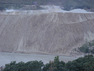
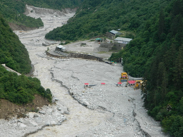
Þ Each of the hydropower project generates immense amount of muck in tunneling, blasting and other activities. A large hydropower project could typically generate millions of cubic meters of muck. The large projects are supposed to have muck disposal plan, with land acquired for muck disposal, transportation of muck to the designated sites above the High Flood levels, creation of safety walls and stabilization process. But all this involves costs. The project developers and their contractors find it easier to dump this muck straight into the nearby rivers. In the current floods, this illegally dumped muck created massive disaster in downstream areas in case of 330 MW Srinagar HEP, the 76 MW Phata Byung HEP and the 99 MW Singoli Bhatwari HEP. When the flooded rivers carry this muck, boulders and other debris, has much greater erosion capacity and also leaves behind massive heaps of this muck in the flooded area. In Srinagar town about 100 houses are buried in 10-30 feet depth of muck. Such debris laden rivers also create massive landslides along the banks.
Þ Wrong operation of hydropower projects can also create greater disasters in the downstream areas. For example the operators of 400 MW Vishnuprayag HEP on Alaknanda river did not open the gates when the river was flooded on June 16-17, possibly to maximize power generation. However, this lead to accumulation of massive quantities of boulders (for photos of dam filled with such boulders see: http://matuganga.blogspot.in/) behind the dam, so much so that that there was no space for water to flow. The river then bypassed the dam and started flowing by the side of the dam, creating a new path for its flow. This created a sudden flashflood in the downstream area, creating a new disaster there.
Þ The incomplete, broken and ill designed protection wall of the Maneri Bhali projects in Uttarkashi lead to erosion and landslides in the downstream areas.
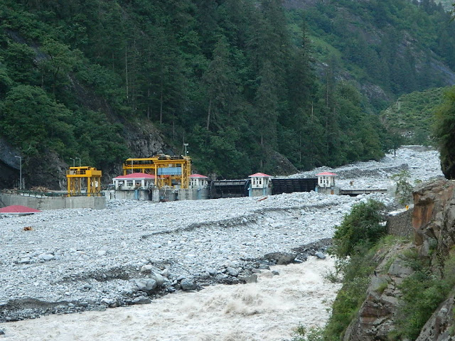
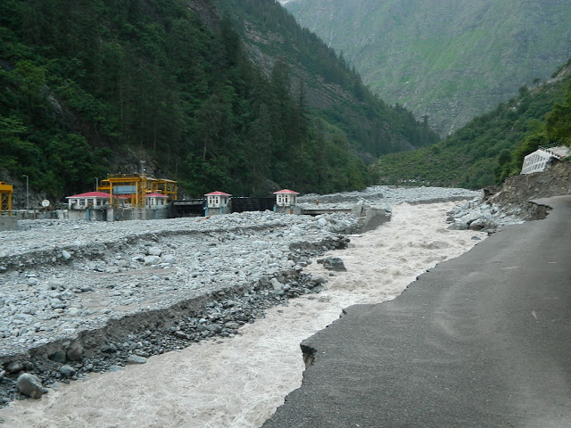
DAMAGED HYDRO PROJECTS A large number of hydropower projects are likely to have suffered damage due to the flood disaster in Uttarakhand. Some of the projects that have suffered damage include:
- According to the update from http://www.energylineindia.com/on June 27, 2013, the 520 MW under construction Tapovan Vishnugad HEP has suffered damaged by rains on June 16, 2013: “While construction of diversion tunnel was completed in April this year, the same was washed away due to heavy rains on June 16. Diversion dyke has washed away and damages have been observed in chormi adit approach road. In August last year, the flash floods had caused serious damages in the coffer dam of the project.”
- 400 MW Vishnuprayag HEP of JP Associates has suffered serious, but as yet unassessed damage(http://www.indianexpress.com/news/jaiprakash-power-tanks-15–as-plant-shuts-down-in-uttarakhand/1133083/). As per MATU PR (http://matuganga.blogspot.in/), the project has also been cause of damage in Lambagad village, which was also flahsed on front page of TOI on June 25, 2013, though without mentioning the project. The blog also provides the before and after pictures of the upstream and downstream of the project.
- 76 MW Phata Byung HEP of Lanco in Mandakini Valley in Uttarakhand
- 99 MW Singoli Bhatwari HEP of L&T in Mandakini Valley in Uttarakhand NDTV India reported that the water level of the river has gone up due to the silt dumped by dams. This is likely to be due to the Phata Byung and Singholi Bhatwari HEPs.
- Kali Ganga I, Kali Ganga II and Madhyamaheshwar HEP, all in Mandakini Valley, all of UJVNL, all hit by mudslides (http://www.indianexpress.com/news/uttarakhands-r500-crore-request-to-prevent-landslides-pending-since-2009/1132351/)
- Assiganga projects on Assiganga river in Bhagirathi basin in Uttarakhand
- 5 MW Motighat I HEP in Goriganga basin in Pithoragarh (Himalprakriti report)
- 280 Dhauliganga Project of NHPC in Pithoragarh district of Uttarakhand (reports said the power house was submerged, but is now working, part of the township was submerged.)
- The Himalaya Hydro (HH) Tanga Phase I for 5 MW, located along the Paina gad in Goriganga basin, is badly damaged. The dam has got smashed by a deluge of huge boulders. One sluice gate is torn through. The metal filter-gates are all choked with boulder debris, and the remnant concrete and gate pulleys of the dam are now stranded mid-river, with both banks eroded and the river now running along the true-left bank. (Himalprakriti report)
- The UREDA 500 KW Motigad microhydel on Moti gadh (a tributary of Paina gadh) at Bindi (Dani Bagad) is also badly damaged. The water has broken through the wall, cut under the foundation, inundated the turbines with water and debris, and smashed the housing for the electrical distribution system. (Himalprakriti report)
- The 5.5′ diameter head race waterpipes taking water to the HH Phase II, located on the Gori opposite Seraghat, has also been damaged. The generator and housing for the HH Ph II has collapsed into the river. All this damage is said to have happened on the evening of 17th June. People working as non-skilled labour have been sent home for a few months, but welding work on the new pipes feeding the powerhouse is still underway! (Himalprakriti report)
It has been now reported in Business Standard (http://www.business-standard.com/article/companies/gvk-l-t-hydel-projects-hit-by-floods-113062300394_1.html) that the 330 MW Srinagar project, a cause for downstream destruction, has itself suffered massive damages on June 17, 2013, with breach of its protective embankment. The report also mentions the damage to the L&T’s Singoli Bhatwari HEP on Mandakini river.
Down to Earth (http://www.downtoearth.org.in/content/hydropower-projects-suffer-severe-damage) has given some details of damage to some of the hydropower projects, quoting UJVNL sources. It says: 19 small hydropower projects have been completely destroyed, while others have been damaged by the raging waters (see table below)
| Project | Location | Capacity | Estimated Loss |
| Dhauli Ganga | Pithoragarh | 280 MW | Rs 30 crore (project completely submerged) |
| Kaliganga I | Rudraprayag | 4 MW | Rs 18-19 crore (power house and 4 houses washed away) |
| Kaliganga II | Rudraprayag | 6 MW | Rs 16 crore (power house and 4 houses washed away) |
| Sobla | Pithoragarh | 8 MW | Rs 14 crore (completely washed away) |
| Kanchauti | Pithoragarh | 2 MW | Rs 12 crore (totally washed away) |
| Chirkila | Pithoragarh | 1.5 MW | Rs 20 crore (part of the project washed away) |
| Maneri Bhali I&II | Uttarkashi | 304+90 MW | Rs 2 crore + Rs 5 crore (walls collapsed, silt in barrages) |
In addition, a large number of projects had to stop generation temporarily due to high silt content, including Maneri Bhali I and II, Tanakpur, Dhauli Ganga, Kali Ganga I, some of the Yamuna basin projects among others.
Conclusion This article was intended to give an overview of hydropower projects in Uttarakhand. However, we should add that there are many glaring issues related to these hydropower projects, some of the key issues include:
- Most of these projects are out of the environmental governance. Projects below 25 MW do not require EIA, Social Impact Assessment, public consultation, environmental clearance, environmental management plan or monitoring. This is clearly wrong as all projects have environmental impacts, and they are particularly serious in Himalayan region with multiple vulnerabilities. We have for years demanding that all projects above 1 MW should need environment clearance, EIA and so on.
- Even for projects above 25 MW we do not have any credible environmental or social impact assessment. Former Environment Minister Jairam Ramesh is on record having accepted that most EIAs are dishonest cut and paste jobs. We do not have any credible process in place to ensure that EIAs are proper and those that are not are rejected and consultants are black listed. Jairam Ramesh did put in place a process of registration of EIA consultants under the Quality Council of India, but that is completely non transparent, unaccountable and ineffective process. It is amazing that reputed NGOs like the Centre for Science and Environment are on board of this process, but they have completely failed to achieve any change and have chosen to remain quiet.
- The Environment clearances of the River Valley Projects (which includes hydro projects and dams) is considered by the Expert Appraisal Committee on River Valley Projects appointed by Union Ministry of Environment and Forests. However, the ministry chooses members of the EAC such that they rarely object to any project. As per SANDRP analysis in six years ending in Dec 2012, the EAC had not said NO to any project for environment clearance. Its appraisal of projects, EIAs, public consultation process and its own minutes were found to be inconsistent, unscientific and loaded in favour of the project developers.
- Our environment compliance system is non-existing. The projects are supposed to implement the environment management plan pari passu with the project work, they are supposed to follow the conditions of environment clearance, follow the environmental norms, but who is there to ensure this actually happens? The Union Ministry of Environment and Forests which is supposed to ensure this compliance has no capacity the officials tell us. The officials do not have time to even check if six monthly compliance reports are being submitted or make any surprise visits. However they do not even seem to have will, since we have seen no change in this situation for decades. Nor do they seem to have willingness, since even when NGOs present photographic and video and other evidence of violations they refuse to take action.
- One way to achieve compliance is to have a project monitoring committee for each project where over 50% of the members are from local communities and other independent persons and such committees ok must be required each stage for the project to go ahead. We have been suggesting this for long, but the MoEF has shown no willingness to follow this.
- More pertinently, none of the assessment reports look at the impact on the disaster potential of the area. Each of these projects have significant impact on the disaster potential of the area, particularly in the context of a vulnerable state like Uttarakhand. This should be a must for all such projects.
- Similarly the projects must also be assessed in the context of climate change, again in vulnerable area like the Himalayas. How the project will impact the local climate, how it will have impact on adoption capacity of the local communities and also how the project itself will be impacted in changing climate. This again we have been writing to the MoEF numerous times, but without any success so far.
- Most significantly, the only impact assessments that we have is for specific projects of over 25 MW capacity. However, we have no credible cumulative impact assessment for any of the river basins of Uttarakhand, which also takes into account carrying capacity of the river basins and all the interventions that are happening in the basins. As our critique of so called cumulative impact assessment of Bhagirathi-Alaknanda basins done by AHEC of IIT Roorkee shows (see: http://www.sandrp.in/hydropower/Pathetic_Cumulative_Impact_Assessment_of_Ganga_Hydro_projects.pdf), it was not much of a cumulative impact assessment. WII (Wildlife Institute of India, Dehradun) report was somewhat better within the mandate given to it (assessment of hydro projects on aquatic and terrestrial biodiversity), but the most important recommendation of the WII report that at least 24 projects should be dropped has not been accepted by the MoEF, so what is the use of the cumulative impact assessment in such a situation?
Unless we address all of the above issues in a credible way, there is little wisdom in going ahead with more hydropower projects in Uttarakhand. They will invite greater disasters. Uttarakhand has many other options for development.
- Firstly people of Uttarakhand should get first right over all the power that is getting generated within Uttarakhand.
- Secondly, this is not a plea for no projects, but to address the crucial issues without addressing which we are in no situation to even know the impacts or address the issues.
- Thirdly, Uttarakhand needs to take up power generation options that do not accentuate the disaster potential of the area. Such options include micro hydro, hydro kinetics, and solar and biomass based power in addition to better utilization of existing infrastructure.
Going ahead with more hydropower projects in current situation would be invitation to greater disasters. In fact, the Uttarakhand government should not allow even the damaged and under construction hydropower projects until al the conditions mentioned above are satisfied.
Some of the hydropower projects that have surely seem to have added to the disaster proportions of current Uttarakhand flood disaster include the 400 MW Vishnuprayag HEP, the 280 MW Dhauliganga HEP, the 330 MW Shrinagar HEP, the 304 and 90 MW Maneribhali II and I HEPs, the 99 MW Singoli Bhatwari HEP and the 76 MW Phata Byung HEP, the last two on Mandakini river.
In response to my question on a programme on Headlinestoday channel anchored by Rahul Kanwal on July 8, 2013 (in presence of panel that also included Dr Vandana Shiva and Vimlendu Jha), the Uttarakhand Chief Minister Shri Vijay Bahuguna agreed that he will institute an enquiry into the damage due to these hydropower projects and hold them accountable for such damage.
Let us see how soon and how independent and credible enquiry he institutes.
– Himanshu Thakkar
South Asia Network on Dams, Rivers & People (www.sandrp.in) July 2013
References:
2. http://www.uttarakhandjalvidyut.com/eoi/list_of_projects_self.pdf and many other UJVNL documents.
4. http://cleanhydropower.blogspot.in/2009/07/brief-description-of-small-hydro-power.html
5. http://ureda.uk.gov.in/pages/show/130-micro-hydro-programme and other sites of UREDA.
6. https://sandrp.in/env_governance/TOR_and_EC_Clearance_status_all_India_Overview_Feb2013.pdf
7. https://sandrp.in/IMG_report_on_Ganga_has_Pro_Hydro_Bias_June2013.pdf
8. http://www.sandrp.in/hydropower/Pathetic_Cumulative_Impact_Assessment_of_Ganga_Hydro_projects.pdf
9. 2012-13 Annual report of Ministry of New and Renewable Energy: http://mnre.gov.in/file-manager/annual-report/2012-2013/EN/chapter3.html
SANDRP blogs on Uttarakhand disaster :
2. https://sandrp.wordpress.com/2013/06/23/uttarakhand-floods-disaster-lessons-for-himalayan-states/
7. https://sandrp.wordpress.com/2013/06/25/climate-justice-statement-on-the-uttarakhand-catastrophe/

How much does the Kasturirangan Committee understand about Water Issues in Western Ghats?
The Ministry of Environment and Forests constituted the Western Ghats Experts Ecology Panel (WGEEP) in March 2010 under the Chairmanship of Prof. Madhav Gadgil. The Panel submitted its report on 31st August 2011. Here on, the report was kept under wraps by the MoEF and only after strict orders from the CIC and High Court was it released to the public in May 2012.
On Aug 17, 2012, MoEF set up the High Level Working Group (HLWG) under the Chairmanship of Dr. K. Kasturirangan to study recommendations of this Report. Members of this Committee include Sunita Narain, Prof. C.R. Babu, J.M. Mauskar, Prof. Kanchan Chopra, Shri Darshan Shankar etc. The HLWG was to look into the recommendations of the WGEEP report and the comments from the various stakeholders. The very constitution of the HLWG raised suspicions that this has been formed to dilute the recommendations of the WGEEP. The functioning of the HLWG left a lot to be desired, it refused to give time to listen to the affected people at many places. On April 17, 2013, after a number of extensions, the HLWG submitted its report.
It seems the HLWG Report (HLWGR) has worked hard to hugely dilute the WGEEP reccomendations. In many cases, HLWG report has made the recommendations of the WGEEP report ineffective. No wonder, Prof. Madhav Gadgil himself has said: “ The initial impression (about HLWG Report) is that there are differences of approach in protecting the ecology of the region. The WGEEP report talks about the facts and we have pointed out that misgovernance is a major issue affecting the ecology of the Western Ghats. This was totally neglected in the new report, which calls for more role for bureaucracy. Providing more power and money to bureaucracy is like giving it to ‘Dusshasana’, and it is a wrong approach” . (http://newindianexpress.com/states/kerala/Kasturirangan-Committee%E2%80%99s-report-favours-bureaucracy-says-Gadgil/2013/04/20/article1553460.ece)
Dilution of WGEEPs strong recommendations is highlighted in the case of 200 MW Gundia Hydel Project in Karnataka and 163 MW Athirappilly Hydel Project in Kerala. While WGEEP Report has categorically rejected these projects based on their severe impacts on ecology and communities, the HLWG has refrained from doing so. The HLWG Report has gone ahead to recommend a few largely irrelevant, measures, while actually giving OK to these projects. Whatever suggestions of review HLWGR has given, the governments would be happy to do the necessary paper work and show that they have done that. The authors of the HLWG report seemed happy to toe the lines that government wants, rather than do justice to the mandate given to them. This was unexpected as both the projects not only have severe impact on ecology, but are also facing stiff and sustained local opposition. The HLWG Report does not seem to give any value or try to understand the reasons behind these local protests.
HLWGR has certified that Athirappilly Project is required for Kerala for peaking power. This is very strange certificate. Do we have an assessment of how much of the power generation from Kerala Hydro projects (incidentally Kerala has one of the highest proportion of installed power capacity under hydro projects, compared to any other state) today is providing peaking power? None. Do we have any credible attempt at ensuring more optimum peaking power generation from existing hydro projects in Kerala? None. Do we have any credible attempt at demand side management in Kerala to manage the peak load requirements? None. Have the KSEB and Kerala government implemented the orders of the Kerala High Court while HC rejected the environmental clearance to the Athirappilly project? No. Then on what basis has the HLWGR certified that “the project’s importance for meeting the peaking power requirements of the State cannot be disputed”?
The other recommendations of the HLWGR about hydropower development in Western Ghats are also problematic. It recommends environmental flows as 30% of lean season flow for hydropower dams, rather than asking for assessment of environment and social requirements of flow in the rivers. These studies cannot be done at a later stage as indicated by the HLWG. It makes no recommendations for flows in other seasons, including monsoon. The HLWG recommends that distance between 2 hydel projects should be minimum 3 kms, again without any basis. It should have asked for site specific studies rather than making such one-size-fits-all kind of recommendation, indicating lack of understanding of environmental issues. It should have at least mentioned ‘distance of free flowing river between two projects should be three kilometre”. Even in case of ROR projects, the submergence itself stretches for kilometres. Cascade hydel dam development which is devastating the Himalayas has not started in Western Ghats. Giving a recommendation like this is in fact inviting more cascades in Western Ghats, that too in the ESA.
The HLWGR has allowed what is it calls Green Growth in the Western Ghats area. But there is no credible process suggested as to who will decide this and how? How will such a process be achieved? Where is the road map to achieve it? The government itself calls all hydropower projects as green growth projects. It is shocking to read that HLWGR also describes all hydropower projects as clean and renewable, exposing their lack of understanding of the hydropower projects and their impacts. The HLWGR seems not bothered by the adverse impacts of such projects on the Western Ghats environment, this is clear in its recommendation agreeing to green growth projects without any credible process.
The HLWG has also not rejected Inter basin transfers from Western Ghats. In doing so, they have quoted justification that “Maharashtra that Rain Shadow Regions” need drinking water. Ironically, all the inter basin transfers happening in Maharashtra (Koyana and six Tata Dams) actually involve transfers FROM the rain shadow region TO water-rich Konkan region for power generation. But the HLWG Report says nothing about this Ulti Ganga. They should have actually recommended stoppage of these diversions if they had the interest of drought prone areas of Maharashtra in mind.
The HLWG Report is also entirely silent on the need to amend the EIA Notification 2006 to include Drinking Water and Industrial Water Supply Dams and Mini Hydel Projects below 25 MW and irrigation projects with command less than 10000 ha under the purview of this Notification. This has been one of the most serious challenges faced by Rivers in Western Ghats right now and the HLWG does not comment on this. It has not commented on dams like Kalu, Shai, Balganga, Lendhi, Gargai, Pinjal, Khargihill which will have a huge impact on Western Ghats ecology and communities. The extent of this damage is evident in the fact that in a recent Forest Clearance granted to Kalu Dam, the Forest Advisory Committee has asked the proponent to follow the recommendations of the Kasturirangan Committee Report. If only the report had made strong and proactive recommendations there was a chance of saving 1000 hectares of forests of Western Ghats
The HLWGR has not commented on fisheries at all.
While a more detailed critical look at the HLWGR will take time, this compilation puts before the readers exact passages from HLWG (see Section A below) and WGEEP (see Section B that comes after Section A) Reports for ready reference. It shows how much understanding of water issues the members of HLWG have or do not have.
– SANDRP
EXCERPTS FROM HLWG AND WGEEP REPORT ON WESTERN GHATS
A. High Level Working Group (HLWG) Report on Western Ghats (Kasturirangan Committee Report)
(HLWG Report Volume I, pp. XII-XXIII)
Out of the estimated 164,280 km2 of the Western-Ghats area, the natural landscape constitutes only 41 per cent. The area identified as ecologically sensitive is about 37 per cent i.e., about 90 % of the natural landscape.
1. Hydropower
Hydropower projects may be allowed in the ESA but subject to following conditions:
(a) Uninterrupted ecological flow at least 30 per cent level of the rivers flow in lean season till a comprehensive study establishes individual baselines.
(b) After a cumulative study which assesses the impact of each project on the flow pattern of the rivers and forest and biodiversity loss.
(c) Ensuring that the minimum distance between projects is maintained at 3 km and that not more than 50 per cent of the river basin is affected at any time.
The villages falling under ESA will be involved in decision making on the future projects. All projects will require prior-informed consent and no objection from the Gram Sabha of the village. The provision for prior informed consent under the Forest Rights Act will also be strictly enforced.
The strategy evolved for the continuation of the Western Ghats Development Programme, in the 12th Plan centres around, besides watershed based development, fragility of the habitat, and development needs of the people i.e. a Watershed + approach – an approach which emphasizes conservation, minimal ecological disturbance, involvement of locals along with sustainable model of economic development and livelihood generation with enhanced allocation.
2. Power/Energy, including hydropower and wind-
(HLWG Report, Volume I, pp. 106-108)
Hydroelectric projects, proposed and planned in the forested regions of the Western Ghats have often come in for opposition. It is clear that as much as the country needs hydroelectric power, which is renewable and clean, but it also needs to balance this requirement with the loss of biodiversity in forests and the need for ecological flow in rivers. Both are essential components and policy must determine that these elements are safeguarded. It is also clear that rivers in India play more than just basic ecological functions. These are lifelines for local livelihood, nutrition and water security. The desire to use the river for generating electricity cannot be at the cost of the value of the river. It is this balance that needs to be maintained. In fact, the potential of hydroelectric power has remained the sole driver for management of the river, particularly in its upper reaches. In the lower reaches, the use of the river for large-scale water diversion projects for irrigation and industrial uses becomes the criterion for development. But these single focus objectives must be enlarged so that the competing – and often the primary needs – can be taken into account at the time of planning and management.
It is also clear that rivers do not know boundaries. Therefore, the conditions for hydropower will be stipulated for the entire Western Ghats and not just for ESA. HLWG recommends that future hydroelectric projects in the ESA and the entire Western Ghats must only be considered on the basis of the following policies:
a. Hydropower development must be based on the acceptance of uninterrupted ecological flow at 30 per cent level of the rivers flow in lean seasons till a comprehensive study establishes individual baselines. The 30 per cent ecological flow is mandated in Western Ghats keeping in mind the shorter length of rivers in this region. The compliance with this condition will require rigorous and seasonal data collection in upper reaches of rivers to prepare a hydrological mapping of the basin. It is also clear that this hydrological assessment is critical given the changes in rainfall patterns because of climate change.
b. Hydropower projects must be considered only after a cumulative impact assessment on the flow pattern of the rivers and forest and biodiversity loss. Currently, individual projects are planned and executed without consideration of these impacts. The Environment Assessment Committees will only consider proposals for individual projects after cumulative impacts have been studied.
c. Current and future hydropower development in the Western Ghats must be based on clear rules that stipulate distance between projects and that do not allow for over-exploitation of the basin. The minimum distance between projects must be maintained at 3 km in most cases (shorter distance requirement because of the short length of the rivers in Western Ghats as compared to other regions) and not more than 50 per cent of the river basin should be affected at any time. This will require reworking the current projects to provide for optimized energy generation but it is necessary given the need to balance development with ecology.
d. Better and more balanced planning for hydropower will lead correct tariff of energy, taking into account the cost of raw material of water. Energy costs, world over, take into account the cost of raw material. It is imperative that the current subsidies and distortions in raw material supply for energy are minimized. It is in this context that water, as the raw material for generation of hydropower, must be factored in the project design. The ecological, social and cultural health of the river is a price that cannot be discounted at the time of planning for the feasibility of power.
e. There is a need to redesign and reevaluate small hydropower projects – below 25 mw as these often have limited impact on energy generation and can lead to huge impacts on ecology. The rationale for small projects must be considered within a policy framework, which provides for mini-grids and local energy distribution.
HLWG about Inter-basin transfers-
(HLWG Volume-I. pp- 100-103)
WGEEP recommendations for sector level planning and their implications
The WGEEP has recommended guidelines for sector-wise activities, which would be permitted in categorized ecologically sensitive area of the region. In this way, regions with the highest ecological sensitivity would have restricted developmental activities – from a total ban on mining to large hydroelectric projects or inter-basin transfer of water and even plantations. The listing is comprehensive and provides an important direction to what will constitute environmentally sound development in this ecologically rich region. The question is how such a development plan will be implemented. Furthermore, it is also important that environmentally sound development should be incentivized and not only practiced through fiat. It is also clear that this recommendation of the WGEEP has evoked the strongest criticism from many quarters. There is apprehension that this ‘blanket prescription’ could be detrimental to economy and livelihoods.
It is also a fact that permit-based regulations are often open for misinterpretation and misuse. A similar issue was raised with the High Level Group on its visit to Maharashtra, when officials explained that there was concern that the WGEEP, if implemented could lead to complete halt of all economic activity. “It would condemn people to live in stone-age”. According to them, the guidelines would not allow for any infrastructure development, from renewable energy to inter-basin transfer of water. This would be a problem, they explained, as many regions of the Western Ghats lie in the rain shadow area and need water to be diverted for irrigation and drinking. Clearly, their concern was the impact of the sweeping nature of the recommendations on the region’s economy. It is not possible to design an effective framework for sustainable development based on such an approach. It is clear that large -scale water diversion projects, which have impacts on the environment and forests, should not be allowed. However, this recommendation should not imply that all water diversion would be stopped even without any study or scrutiny about the individual project or cumulative impact of the projects.
HLWG recommendations for two hydel projects that were categorically rejected by the WGEEP Report
- 163 MW Athirappilly HEP, Kerala:
HLWG is of the view that while the importance of the proposed Athirappilly hydropower project for meeting the peaking power requirements of the State cannot be disputed, there is still uncertainty about ecological flow available in the riverine stretch, which has a dam at a short distance upstream of the proposed project.
It recommends that given the increased variability due to unpredictable monsoon, the project must be revaluated in terms of the generation of energy and whether the plant load factor expected in the project makes it viable against the loss of local populations of some species. Based on this revaluation and collection of data on ecological flow, the Government of Kerala, could take forward the proposal, if it so desires with the Ministry of Environment and Forests.
The HLWG along with the officials of Kerala State Electricity Board and Kerala Forest Department visited the Athirappilly Hydropower Project, after hearing the presentations made by Kerala State Electricity Board (KSEB) and also a local NGO (River Research Centre, Trissur). The team visited the dam site, the settlement of Kadar tribes impacted by the dam, rapids and waterfalls and irrigation dam site. During presentation, the KSEB explained the upstream run of the river hydropower projects – the Sholayar project on the Sholayar river which is tributary of Chalakudy river, the tail water of which is discharged into downstream that flows into Poringalkuthu project which is on the main river itself, the tail water of which is discharged into downstream of Chalakudy river and is used for the proposed Athirappilly project which is about 40 km away from the backwaters of Cochin. All these projects are run of the river projects and there are no dry stretches of the rivers. If these streams/rivers are not dammed, the excess monsoon run off cannot be stored and enters into sea within 48 hours. The average annual inflow, based on 32 years data at Athirappilly, is 1169.Mm3. This is confirmed from the flow data of Chalakudy river at Arangals collected by Central Water Commission. The tail water from Athirappilly will be released into Chalakudy via its tributary at Kannankuzhithodu.
The fluctuations in the water flow in different months and the plant load factor were also explained. The issues relating to Kadar tribal families living close to the submergible portion of the dam were explained to HLWG and it was informed that a package has been worked out for their welfare without rehabilitation as the areas inhabited by them does not come under submergible zone. The NGOs, who met with HLWG, brought to its attention that project would have irreversible impact on the rich biodiversity value of the forest; particularly, along stretch of 7.89 km between dam site and the point where the tail race water joins Chalakudy river. They said that the habitat of the Kadar tribal population would be adversely hit and that people had not yet given their consent. In addition, they said that this project, being built in an area of biodiversity value, would have minimal benefits. The technical feasibility of the project was doubtful with meager amount of power obtained at high cost. In addition, plantation owners and farmer representatives located below the proposed project said it would have adverse impacts on downstream irrigation and drinking water.
The HLWG examined the status of forests, including the riparian forests and submergible slope forest, a small swampy area and the plantations. It is clear that as in all hydropower projects, there is a need to balance the need for energy, particularly peaking power, water supply and irrigation with the loss of biodiversity, forest habitat, displacement of tribal communities and the need for ecological flow in the river.
HLGW, after detailed deliberations on each of the critical issues, is of the view that while the project’s importance for meeting the peaking power requirements of the State cannot be disputed, there is still uncertainty about ecological flow available in the riverine stretch, which has a dam at a short distance upstream of the proposed project. Given the increased variability, in flow from catchments due to unpredictable monsoon rains, the project may be revaluated in terms of the generation of energy and if the plant load factor expected in the project makes it viable against the loss of local populations of some species. Based on this revaluation and collection of data on ecological flow, the Government of Kerala, could take forward the proposal if it so desires with the Ministry of Environment and Forests.
- 200 MW Gundia HEP, Karnataka:
As the proposed Gundya hydropower project is located in the ESA, it must be proceeded upon with extreme caution. HLWG recommends that the Government of Karnataka should reassess the ecological flow in the downstream areas, based on a thorough evaluation of hydrological regimes in the area. The project should not be given the go-ahead, till such a review and reassessment is made. The Government’s review must also assess local damage to all forests, which will emanate from the construction work and if at all, this can be mitigated. The HWLG has not proposed a complete ban on the construction of hydropower projects in the ESA, but its recommended conditions that balance the needs of energy with environment, must be followed.
Background: The Karnataka Power Corporation Limited (KPCL) has proposed a hydroelectric project in the Gundya River basin in the Hassan and Dakshina Kannada district in two phases: Phase I of 1x 200 MW and Phase II of 1x 200 MW. The project is on Gundya river – a tributary of west flowing river of Netravathi; phase I involves pooling of waters by linking Yettinahole, Kerihole, Hongadhalla and Bettakumari and water from these streams will be intercepted by small weirs and will be drawn through a tunnel running from Yettinahole leading to Bettakumari reservoir. From the foreshore of this reservoir, 7.8 km long head trace tunnel takes water to a surge tank and from there to an underground powerhouse. The Phase II will have two tunnels – one tunnel will take water from Kadumanehalla and surrounding areas by 13 km long unlined tunnel and discharge into tunnel that takes water from Yettinahole weir, and another tunnel of 15 km long will take water from Lingath hole and Kumaradhara to Bettakumari reservoir. The submergible area will be 184.64 ha. An additional 560 ha will be needed for infrastructure. KPCL is not going ahead with the Hongadhalla dam because of the extensive submergible area of 523.80 ha. The project has got necessary clearances from different regulatory agencies; EAC of MoEF has asked KPCL to conduct also public hearing in Dakshna Kannada District, as project area falls in both the districts. The public hearing was conducted at Siribagiln village of Puttur taluka on 25.03.2009. Meanwhile the Malenadu Janapara Horata Samithi made a representation before the subcommittee of EAC during its visit to the site on 5.12.2009. The EAC has recommended clearance but the MoEF has not issued the environmental clearance.
The land required for the project includes forest area of 113 ha, revenue land of 263.63 ha, which also includes forests (though mostly degraded); and 71.5 ha of private land making it a total of 448.13 ha. The site has unique forest types with high biodiversity values (endemic, rare, threatened and new species) and also the cardamom and coffee plantations with scattered forest patches, which will be impacted adversely by land use changes and changes in hydrological regimes in the river basin due to project.
The major impacts of the project would be: (i) submergence of patches of riparian forest, (ii) land degradation/fragmentation of forest patches for tunneling and road construction; (iii) the drying up of down streams of three Yellinahole (with 60.50 km2 catchment area), Kerihole (27.00 km2 catchment area), Hongadahalla (8.50 km2 catchment area) and Bettakumari (35.00 km2 catchment area) before they join Gundya river, although each of them has small catchments, and a stretch of 34 km of Gundya river; and (iv) the apprehension of shortage of water at Subramanya Swami temple.
HWLG notes that the Gundya hydel project is run of the river project, which must ensure ecological flow in the affected stretch of the river. Furthermore, while the area of the submergible portion of forest is small, the construction of the project and tunneling in the region will have adverse impacts on both government forests and green areas on private land. As the Gundya hydropower projects is located in the ESA, HLWG recommends that it must be proceeded upon with extreme caution. It would recommend that the Government of Karnataka should reassess the ecological flow in the downstream areas, based on a thorough evaluation of hydrological regimes in the area. The project should not be given the go-ahead, till such a review and reassessment is made. The Government’s review must also assess damage to all forests, which will emanate from the construction work and if at all, this can be mitigated. The HWLG has not proposed a complete ban on the construction of hydropower in the ESA, but its recommended conditions that balance the needs of energy with environment must be followed.
B. WESTERN GHATS EXPERT ECOLOGY PANEL (WGEEP) REPORT
Athirappilly and Gundia Hydel projects
WGEEP Categorically rejects both the projects for their impact on communities and ecosystems.
Sectoral Recommendations relating to Water
Recommendations for ESZ I, II, III-
Decentralized water resources management plans at Local Self Government level Protect high altitude valley swamps and water bodies. Catchment area treatment plans of hydroelectric and major irrigation projects should be taken up to improve their life span. Improve river flows and water quality by scientific riparian management programmes involving community participation Water conservation measures should be adopted through suitable technology up gradation and public awareness programmes inter-basin diversions of rivers in the Western Ghats should not be allowed
Hydropower projects
For ESZ I-
- Allow run of the river schemes with maximum height of 3 m permissible which would serve local energy needs of tribal/ local communities / plantation colonies subject to consent of gram sabha and all clearances from WGEA, SEA and DECs.
- No forest clearance or stream diversion for new projects
- Run of the river schemes not allowed in first order or second order streams
- Promote small scale, micro and pico hydropower systems, that are people owned & managed and are off grid
- New small hydropower projects (10 MW and below) are permissible
For ESZ II-
- Small bandharas permissible for local and tribal community use / local self- government use
- No new dams above 15 m or new thermal plants permissible
- New hydro projects between 10- 25 MW (up to 10 m ht) permissible
- All project categories subject to very strict clearance and compliance conditions through SEA and DECs of WGEA
- Have run off the river hydropower projects but after cumulative impact study of the river basin is done
For ESZ III-
- Large Power plants are allowed subject to strict environmental regulations including 1. Cumulative impact assessment studies 2. Carrying capacity studies 3. Minimum forest clearance (norms to be set by WGEA) 4. Based on assessment of flows required for downstream needs including the ecological needs of the river.
- For already existing dams reservoir operations to be rescheduled for allowing more water downstream
Common recommendations for all the three zones-
- No diversion of streams/ rivers allowed for any power projects and if already existing, to be stopped immediately.
- Catchment area treatment in a phased manner following watershed principles;
- Continuous non-compliance of clearance conditions for three years would entail decommissioning of existing projects
- Dams and thermal projects that have crossed their viable life span (for dams the threshold is 30–50 years) to be decommissioned in phased manner
- All project categories to be jointly operated by LSGs and Power Boards with strict monitoring for compliance under DECs
Fisheries
Recommendations for ESZ I, II, III-
- Strictly control use of dynamite and other explosives to kill fish; provide fish ladders at all reservoirs Introduce incentive payments as ‚conservation service charges‛ for maintenance of indigenous fish species in tanks under control of Biodiversity Management Committees or Fishermen’s co-operatives; monitor and control trade in aquarium fishes with the help of Biodiversity Management Committees
Water use-
(WGEEP Report Volume II, pp. 32-37)
Water resources management in the Western Ghats region is inextricably linked to improving the flows in the rivers and the health of the catchments. Western Ghats is the origin of many of the important Peninsular Rivers like Cauvery, Krishna and Godavari that drain the Deccan Plateau and flow eastwards. The hundreds of shorter perennial monsoon fed west flowing rivers like Sharavati, Netravathi, Periyar, and the Bharathapuzha travel through steeper and more undulating topography before emptying into the Arabian Sea. A rough estimate reveals that 245 million people in the five Western Ghats states directly depend on these rivers for their diverse water needs. Geographically, the Western Ghats is the catchment for river systems that drain almost 40 % of the land area in India. The basin area of west flowing shorter rivers is mostly located on the steep western slopes. Except for a few coastal streams 1/3 rd of the basin area of most of the river basins is located within the Western Ghats. This too makes them fragile and calls for their proper care and management. Once these streams leave the Western Ghats proper, they are drained and enriched by the once fertile steep river valleys, midlands and flood plains. The coastal and backwater fisheries is sustained by the rich nutrients and sediments brought down by the flowing rivers. The musings by fisher folk in coastal Kerala: ‘The Sea begins in the mountains and ‘fertility of the coast and the plains depends on the wealth from the rivers’ holds significance in this context. Open dug wells and springs are the other important water resources being extensively used for irrigation and drinking water purposes in the Western Ghats region. In several places, water–‐ harvesting structures dependent on rainwater are also used. In the Sigur plateau, numerous drinking water schemes dependent on the Moyar River are being operated for the tribal and dalit populations. Bore wells have made their entry in the recent past due to intensive irrigation patterns and lowering of water tables. As for Kerala, the groundwater potential is low when compared to other states and shallow dug wells are the most common source of freshwater. However, over the years the groundwater table is lowering at an alarming rate indicative of poor recharging capacity. On the other hand, water needs for drinking water, energy, irrigation and industrial purposes are growing in the Western Ghats States. More and more water is being diverted even from irrigation dams to meet the thirst of the expanding urban spaces and for industries. We have examples of Siruvani, Kabini, Peechi and Malampuzha reservoirs across the Western Ghats where irrigation water is being diverted for drinking and for the industrial needs of cities in the midlands like Coimbatore, Bangalore and Mysore, Thrissur and Palakkad respectively. New dams are being planned and some of them are in different phases of construction in the Maharashtra Western Ghats to meet the expanding needs of Mumbai and its suburbs. Pinjal, Shai, Gargai, Kalu and Vaitarani dams are recent cases. Water abstraction through check dams across hill streams is being practiced for decades by tea and coffee plantations in upstream catchments of rivers to meet their drinking and irrigation needs. This has resulted in cutting off the stream flows at their origin itself. Indiscriminate and unplanned tourism is another reason for increasing water abstraction and diversion. The tourism industry in Ooty depends on the reservoirs constructed across the tributaries of the Cauvery in the high mountains since the times of the British. Studies reveal that east–‐ flowing Rivers like Krishna, Cauvery are struggling to reach the seas due to over abstraction of both surface and groundwater. Basins are closing and its impact is felt even on delta fishing, farming livelihoods and ecology. During the 2001-2004 drought years, the discharge from the Krishna to the ocean was almost nil! As for the west-flowing rivers, saline ingress is advancing even into the midlands due to reduced downstream flows. Crop losses and saline water intrusion into drinking water has been reported in Kerala during severe summer owing to salinity intrusion. In Goa, mining has affected groundwater and surface flows and drainage patterns of rivers impacting downstream needs and water quality. Tailings from mines are polluting streams and rivers. The Kudremukh mining issue is a classic case of mining- related pollution. This mountain range has a long history of human interventions and each of these have directly or indirectly impacted upon the water resources availability and recharge in the region. Some of the important interventions and issues that have had lasting impacts on water resources and its management in the Western Ghats are briefly discussed below.
Issues of Concern
Forest destruction in the river catchments
Western Ghats has a long history of deforestation. Deforestation of upper catchments of rivers for timber, river valley projects and plantations has drastically reduced the capacity of the hill streams that feed into the rivers to hold and recharge water. Drying up of streams immediately after the monsoons and desiccation related to deforestation is clearly evident. This in turn has contributed to reduced summer flows.
River management in the Western Ghats
Most of the rivers in the Western Ghats are either dammed or diverted, some of them at several sites for power generation in the upper reaches and irrigation in the lower reaches. For instance, the east–‐‑flowing tributaries of Cauvery (Bhavani, Moyar, Kabani) and Krishna (Bhima, Tunga, Bhadra) are already dammed. The west–‐‑flowing shorter rivers (Sharavathi, Periyar) have been dammed at several places. We also have complete diversion of river flows at Mullaperiyar and Parambikulam dams involving Kerala and Tamil Nadu. West-flowing rivers have been virtually made into east–‐‑flowing Rivers by violating all natural laws. Dams are without dispute the most direct modifiers of river flows. They can heavily modify the magnitude (amount) of water flowing downstream, change the timing, frequency and duration of high and low flows and alter the natural rates at which rivers rise and fall during runoff events. Severe daily flow fluctuation between peak and off peak times below dams is commonplace in west–‐‑flowing dammed rivers. This has impacted drinking water schemes, major and minor irrigation projects operating in downstream areas apart from cutting off flood plains and impacting aquatic ecology and riparian systems. However very few studies are available that correlate the reservoir operations with the different types of downstream impacts and put measures in place for mitigation. In the case of inter-basin water, no water flows or even
The Mullaperiyar dam is a classic case where the main tributary of Periyar has been completed diverted to the Vaigai basin in the east. Idukki dam does not even have a spillway for allowing monsoon spills into the river. In Maharashtra, the tail race discharges of Koyna Powerhouse I, II and III are released into the west–‐‑flowing Vashishthi River and lead to heavy floods in Chiplun. Continuous stretches of rivers have dried up irreparably below diversions affecting river ecology, surface flows and even ground water seepage. Many of the reservoirs especially in the steep valleys are silting up prematurely due to the massive encroachment and deforestation of catchments consequent to dam construction. Idukki dam is a classic case wherein the entire catchment was encroached along with dam construction. The operations of hydroelectric stations (reservoir operations) are in tune with the power needs rather than the downstream water needs. Hence daily flow fluctuations created by peak and off peak operations of reservoirs in dammed rivers have led to upstream- downstream conflicts in many river basins. Similarly diversion of flows into another river basin after power generation is creating problems of daily flood in the recipient basin and drought in diverted basins. These are turning into management issues which need to be addressed at a basin level. However, there is a lack of systematic river basin level data on ecological changes due to hydrological alterations created by dams.
Incorrect land use patterns
Mining for mineral ores, granite and lateritic mining has affected water availability and recharge especially in the lower altitude regions and midlands. In Goa alone, the government itself has acknowledged that over half of the 300 odd mining leases are located close to water bodies. Data tabled in the Goa Assembly revealed that several of the 182 mining leases exist within one kilometer of a major irrigation project, the Selaulim dam, which provides drinking water to six lakh people in south Goa, virtually half the population of Goa (Ref: Deccan Herald Article).
In South Karnataka and North Kerala, surangams, a traditional irrigation system in lateritic hills is losing out to lateritic mining. Many of the rivers in this region originate from these lateritic hills and many of the Western Ghats Rivers like Chandragiri, Valapattanam, and Netravathi benefit from the water recharged by lateritic hills in their flow downstream.
Agricultural practices including cropping patterns have a role to play in water resource management in the Western Ghats. Planting steep slopes with soil–‐‑eroding monocu;ture crops like rubber and banana, and heavy tillage, has led to increased surface runoff along with loss of precious top soil. This has contributed to low seepage and infiltration into deeper soil depths. The deforestation for tea, coffee and cardamom plantations located at higher altitudes has contributed to drying up of hill streams.
Reclamation of high altitude valley swamps is contributing to water scarcity in the upper catchments. Many of the rivers originate from these swamps and are source of perennial flow. In the Nilgiris, most of the fertile water rich swamps have been converted for intensive pesticide-based farming, greenhouse farms, housing, etc.
Sand mining
Most of the rivers in Western Ghats are facing the consequences of indiscriminate sand mining. The lowering of water tables and deterioration of water quality are the immediate impacts. River beds in some stretches are lower than the sea level accelerating saline ingress. Drinking water scarcity is on the rise in river bank panchayats in spite of being close to the river. Plan funds are spent for providing drinking water even to panchayats on river banks. Sand mining has also impacted breeding and feeding grounds of fish and other aquatic species
Measures for Mitigation/Improvement
Time for river basin-level planning and decentralised management of water resources in the Western Ghats As cited above, the impacts of incorrect land use and interventions are already evident. Reduced summer flows, flow fluctuations, lowering of water tables and degrading water quality are all direct impacts of the presently followed project–‐‑oriented, demand-supply based and ad hoc approach to water resource planning and management. The time is ripe for a paradigm shift in approach to river basin–‐‑level management of water resources where water is considered an integral part of the ecosystem. Some important measures that can be adopted in this regard are briefly detailed.
1. Local self–‐‑ government level decentralized water management plans to be developed at least for the next 20 years: Water resource management plans with suitable watershed measures, afforestation, eco–‐‑restoration of catchments, rainwater recharging and harvesting, storm water drainage, water auditing, recycling and reuse etc. should be built into the plans. These water management plans should integrate into basin level management plans. The objective is to reduce the dependence on rivers and external sources and to improve recharge.
2. Reschedule reservoir operations in dammed rivers and regulate flows in rivers to improve downstream flows and also to act as a conflict resolution strategy. These should be implemented with an effective public monitoring system in place.
3. Revive traditional water harvesting systems like recharge wells, surangams, etc.
4. Protect high altitude valley swamps that are the origins of rivers from further reclamation and real estate or agricultural development and declare them as ‘hotspots for community conservation’
5. Participatory sand auditing and strict regulations to be put in place.
6. Declare “sand holidays’ based on assessments and sand audits for mined river stretches. Items 5 and 6 would work to improve the water retention capacity in the river.
7. Rehabilitation of mined areas to be taken up by the companies / agencies with special focus on reviving the water resources like rivers, wells, tanks, etc. that have been destroyed by the mines.
8. Planters, local self–‐‑governments and Forest Departments in high altitude areas should come together for eco–‐‑restoration of the forest fragments between the tea and coffee estates and revive hill streams.
9. Take up catchment area treatment plans of hydro and major irrigation projects to improve their life span.
10. Riparian management can be taken up with community participation and involvement to improve river flows and water quality.
11. Water conservation measures should be adopted through suitable technology upgradation and public awareness programs.
12. Reconnect children and youth to rivers and water resources through basin level education programs.
Actionable points for the WGEA-
The (proposed) Western Ghats Ecology Authority (WGEA) can take a strong recommendatory and advisory role in this regard. Some of the important recommendations for WGEA are:
1. Declare origins of rivers as Ecologically Sensitive Localities (ESLs) (the catchment area)
2. Many projects in the Western Ghats are on–‐‑going or completed with violations in environmental clearance and forest clearance or even no clearances at all, as in the case of the Kalu and Shai dams in Maharashtra. The WGEA should act as an additional layer for screening projects approved by the Expert Appraisal Committees (EACs), subject them to additional scrutiny in terms of the geographical context, ecological sensitivity, status of river basin and need for environmental flows taking into consideration all season flows instead of ad hoc allocations.
3. Till the WGEA comes into operation, issue a moratorium on all on–‐‑going projects like dams and mines that can impact upon water resources in a substantial way. The WGEA should subject the projects to scrutiny for mandatory clearances and compliances, and augment the level of public consultation before deciding on whether to allow them to progress or not.
4. No more inter–‐‑basin diversions of rivers shall be allowed in the Western Ghats.
5. Take up sample river basins in each state and recommend to the State Governments to carry out:
- Environment flow assessments involving social movements for river protection, research institutions, NGOs along with communities to put in place indicators for environmental flow assessment
- Assessment of downstream impacts of dams on river ecology, flood plains, fishing habitats, livelihoods, etc.
- Salinity intrusion mapping so as to suggest improved flows in future
- Improve reservoir operations management in dammed rivers to improve meeting of water needs of downstream populations. Put proper monitoring of reservoir operations in place involving downstream local self–‐‑governments and departments.
- Update and upgrade hydrological databases in rivers and consolidate the ecological database and information at river basin level
- Based on the consolidation of databases, declare high conservation value stretches of rivers as ESAs and keep them free them from further development.
6. Recommend to State Governments to take up decentralized bottomup river basin planning with restoration built into the plans.
7. River Basin Planning should be supported by suitable legal institutions that are capable of integrating different departments which are presently dealing with or impacting on the rivers in a compartmentalized manner. Put in place river basin organizations adapted to state administrative context.
8. All new projects in the Western Ghats (dams, mines, tourism, housing, etc. that impact upon water resources) should be subject to cumulative impact assessment and should not exceed the carrying capacity.
9. Stronger and stricter laws for regulation of sand mining to be developed
10. Recommend the decommissioning of dams that have outlived their utility, are underperforming, and have silted up beyond acceptable standards, etc.
Fisheries
(WGEEP, Volume II, pp. 48-49)
Depletion of the fishery resources is a serious issue in the Western Ghats region. Compared to marine fish resources / biodiversity, the freshwater fish diversity is on the decline due to various reasons. Traditionally the conservation and management of fishery resources were vested with local communities, but this has now been altered. Several innovative measures are required to revive this highly valued resource and to use it in a sustainable manner on account of its relevance in livelihood improvement and food security. There is a need to readdress these issues with the fisheries department and other impacting sectors to reorient conservation measures in a participatory mode. Furthermore, local fish consumption has been a traditional source of protein for local people from time immemorial.
Issues of Concern
- Habitat loss, including loss of mangroves
- Pollution due to pesticides, industrial effluents/other sources
- Waste dumping in rivers
- Improper river maintenance and management
- Unscientific methods of collection (use of poisons, electro–‐‑fishing, dynamiting etc.)
- Impoundments in rivers, check dams
- Introduction of exotic fishes
- Destruction/loss of breeding grounds
- Fish diseases
- Overexploitation
- Unauthorised ornamental fish trade
- Sand mining
- Excessive tourism activities in freshwater lakes
- Decline of indigenous species due to introduction of exotic and alien fishes species
Measures for Mitigation/Improvement-
- Regular monitoring of fish wealth to assess the health/ diversity of the fish population.
- Banning the use of plastics which settle at the bottom of water bodies and lakes and affect breeding of some species.
- Management measures aimed at conserving freshwater fish biodiversity to be incorporated into the fishery policy.
- The database on population size and geographical distribution of endangered and endemic species should be strengthened by undertaking extensive micro–‐‑geographical surveys. Information on area of distribution and micro–‐‑geographical characteristics of the habitats of these ecologically sensitive fishes will be inputs for establishment of aquatic reserves for the conservation of these species.
- Information regarding migration, breeding behavior and spawning grounds of threatened fishes should be generated through extensive surveys and analysis. Such a database is essential for both ex situ and in situ conservation of the species.
- Techniques should be developed for the captive breeding and brood stock development of fishes of potential economic importance.
- Brood stock maintenance centers and hatcheries should be established exclusively for indigenous, endangered and critically endangered fishes for their in situ conservation and aqua ranching as a substitute for their natural recruitment.
- Investigation on the invasive nature of exotic species in the natural habitats should be carried out. The functioning of the committee constituted under the Government of India to quarantine and control introduction of exotic species should be made more effective and foolproof.
- Strict vigilance and monitoring, including enforcement of laws, to be ensured to reduce the loss of the natural breeding grounds of the fishes arising from reclamation of paddy and wetlands.
- Strengthen awareness programs to ensure the sustainability and survival of fish resources.
- Regulation on fishing, during breeding seasons in freshwater environs to restore natural/ wild stock
- Establishment of fish sanctuaries
- Sand mining and other activities which destroy the habitat of many endemic fishes to be restricted.
- Live–‐‑fencing using native plant species instead of stone walls to be encouraged for protecting river banks.
- River Management Funds to be utilised for activities related to river health programs and not for construction or other developmental activities.
- Regulation of ornamental fish collection from the wild.
Compiled by Damodar Pujari, SANDRP (damodar.sandrp@gmail.com)

Power of Micro Hydro in Nepal
Great article on how micro hydel projects are changing the face of rural and remote Nepal..interesting to note that 20% funds for setting up a micro hydel projects come from the community and these projects take just 21 months on average to start producing. Thats seems like a remarkably short gestation period. In Chitwan region, there are villages which have not taken a penny from the government and have set up their own micro hydel projects. The electricity bill per family in this remote setting is barely 40-50 Rs. per month. It would have taken years or even decades for grid connected power to reach these areas.
Grid connected small and large hydros have not contributed this brilliantly to the local electricity scene.
So we have a states like Uttarakhand where hydros generate more than 3000 MW of power, but most of it is sold outside and more than 1200 villages are still without electricity, having lost their rivers in the bargain. In the same Uttarakhand, agencies likes UREDA are working on micro hydel projects less than 2 MW and have till now electrified more than 250 villages with just 3.41 MW. Unfortunately, the large dam lobby neglects these projects entirely as they do not generate market based profits. These are the projects and initiatives which deserve support through mechanisms like CDM. But

, the large hydro dominated scene right now is just Andher Nagari Chowpat Raja.
Incidentally, Climate Change is a spoiler for these micro hydels too. This year in Nepal, many villages had to again succumb to darkness as the water levels in rivers fell abnormally. A great adaptation and mitigation measure against Climate Change is itself so vulnerable to its impacts..
http://www.myrepublica.com/portal/index.php?action=news_details&news_id=35851
