Thermal, Hydro Power projects on the blink despite clearances by government (23 July 2015) Power sector is now bereft of capital flow. While thermal power projects might see some respite, hydropower projects continue to fester even after getting all the clearances. This puts a question mark on the claims of the hydro lobby that environment ministry and environment clearances are responsible for delaying the projects. Of the 80 stalled power projects, around 25 are hydro-based. Due to delays, the cost of the project, in almost all cases, has increased manifold thereby inviting regulatory tiff over tariff. NHPC’s Subhansari Power Project remains stalled due to the agitation in Assam. NHPC officials need to be held accountable as to how did they start the work without addresing the downstream impacts issues. Due to their callousness, the cos has doubled and work is stlled for over 3.5 years. http://www.business-standard.com/article/economy-policy/power-projects-on-the-blink-despite-clearances-by-government-115072200024_1.html
JAMMU & KASHMIR: Baglihar Hydro Electric Power project threatens Doda, Kishtwar (27 July 2015) Baglihar HEP is making life difficult with landslides, floods and additional submergence: “Before construction of dam, rocks were visible on both banks of the river. But when water level increased and became stagnant, rocks are nowhere in sight and water has entered loose soil. The root cause of frequent landslides and sinking of area in Doda districts on both side sides of the dam is stagnant water.”GM Bhat, Geological expert. http://www.tribuneindia.com/…/baglihar-power-pr…/111641.html
UTTARAKHAND: Vishnugad-Peepalkoti Hydroelectric Project affected protested against World Bank (09 July 2015) The affected people of Vishnugad-Peepalkoti Hydroelectric Project (VPHP) have surrounded the officers of World Bank with the slogan of “World Bank Go Back, Let Ganga free”. In even the bad weather and rain, almost 70-80 people have surrounded the hotel in which the team of World Bank was staying. Their officers were present there from 03rd July without the knowledge of villagers. After the incident, Ms.Sona Thakur of World Bank has came out and asked them to sit and talk inside the hotel. https://www.facebook.com/sandrp.in/posts/1083146828379656
MHA to Monitor Landslide Dams to Avoid Any Disaster (10 July 2015) The threat of severe earthquakes in the Himalayan region close on the heels of the devastating one in Nepal, as indicated by several scientific studies, has prompted India to put hundreds of landslide dams or LSDs under constant monitoring so that they do not break with catastrophic consequences. The Centre has roped in the National Remote Sensing Centre, Central Water Commission and the Indian Air Force as part of the new SOPs to ensure continuous monitoring of the quantity of water flow of all major rivers in the upper reaches by visual, instrumental, aerial and satellite surveillance, and ascertaining the cause of a reduced water flow at the earliest. http://epaperbeta.timesofindia.com/Article.aspx?eid=31818&articlexml=MHA-to-Monitor-Landslide-Dams-to-Avoid-Any-10072015003067
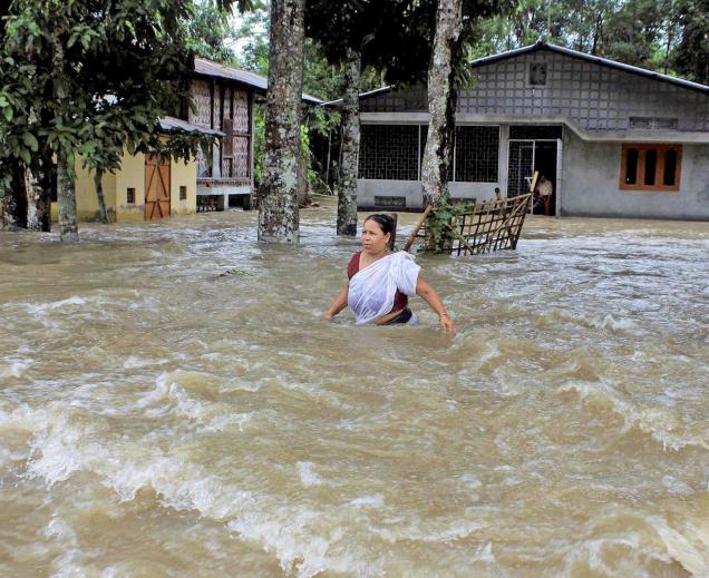
NAPM Press Release: Frustrated over long delay in rehabilitation, Sardar Sarovar Project Affected Commits Suicide (10 July 2015) Yesterday, on 9th July 2015, in the village Chimalkhedy, barely 10 to 12 kms away from the Sardar Sarovar Dam, TembhryaKutarya consumed poison and committed suicide. This news reveals the actual dire reality underlying the false tall claims of rehabilitation by Maharashtra Government. While this press note is being drafted the dead body of the old man Tembhrya Kutarya is decaying on the banks of the river Narmada in the village Chimalkhedy and the Govt. is “still thinking” how to take MBBS doctor there to do postmortem. Dr. Anil Patil appointed on the riverine dispensary on the medical barge that is very irregular, in spite of being in Kevadia colony (the colony near SSP) since yesterday morning was apparently neither aware of nor was concerned about this incident. https://www.facebook.com/sandrp.in/posts/1083835098310829
Constructing new dams will hinder mission to clean Ganga, says Uma Bharti Flagging her concerns against the major culprit (hydro-power projects), the Union water resources minister Uma Bharti has asked different ministries including environment and power to take a cautious approach while allowing construction of any new dam on the river. Her ministry is particularly against the six contentious hydro power projects in Uttarakhand which, it thinks, would severely affect the e-flow of the Ganga. Environmentalists had already pitched for scrapping of such projects that they believe may lead to another June, 2013-like disaster in the region. (June 24, 2015: http://timesofindia.indiatimes.com/home/environment/pollution/Constructing-new-dams-will-hinder-mission-to-clean-Ganga-says-Uma-Bharti/articleshow/47793769.cms)Continue reading “Dams, Rivers & People: June 29, 2015”→
“Right now, hydel is almost stalled”: Piyush Goyal (18 May 2015)
Union Power Minister makes some candid comments on Hydro: “Right now, hydel is almost stalled. We have Teesta stuck for various reasons. Subansiri, Maheshwar, Lower Subansiri, all of them have different challenges. Small hydros are facing challenges of transmission, they are facing challenges of local area problems. So, by and by, the hydro sector will need a more holistic thinking. The courts have also taken up certain matters, particularly in Uttarakhand, post the tragedy (of floods in 2013). There is the mission of Ganga to ensure that there is a reasonable flow—Aviral Ganga, which we are committed to. We are working on all of these plans… For example, Subansiri had an issue where the local population had concerns. We immediately got an eight-member very, very high-level expert committee, including Central Water Commission, Central Electricity Authority, and experts from Assam. They are all working together to see the environmental impact, structural impact, riparian state impact and riverbed impact.
A three member committee set up by the Union Ministry of Water Resources, River Development and Ganga Rejuvenation (MoWR for short) has submitted a report in March 2015, which makes welcome recommendation on “Assessment of Environment Flows”. These recommendations on Environmental Flows (E-Flows) need to be implemented immediately for better health of our rivers. The committee members include Dr Vinod Tare of Indian Institute of Technology Consortium (IITC), senior officials of Union Ministry of Environment, Forests and Climate Change (MoEF for short, it was represented by Dr Shashi Shekhar, Special Secretary in MoEF) and MoWR (represented by Dr Amarjeet Singh, Additional Secretary, MoWR). Sushri Uma Bharti, Union Water Resources Minister[1] and even the recent meeting of National Ganga River Basin Authority (NGBRA) on March 26, 2015[2], headed by the Prime Minister referred to this committee. Continue reading “MoWR report on “Assessment of E-Flows” is welcome, needs urgent implementation”→
रिपोर्टर:- सुशील बहुगुणा, कैमरामैनः- सुदीश कुमार राम, एडिटरः- कुलदीप कुमार, एन.डी.टी.वी.- इंडिया
रिपोर्टरः- जून 2013, उत्तराखण्ड में, नदियों के साथ आई तबाही की ये तस्वीरें। तस्वीरें जो हमें मजबूर करती हैं, ये समझने को, कि आखिर ये नदियाॅ इतनी रौद्र, इतनी विकराल क्यों हो रही हैं ? ये नदियाॅ हमारे घर-आॅगन क्यों उजाड़ रही हैं ? कहीं हम ही, इन नदियों के अहाते में तो नहीं घुस गए ? कहीं हमने नदियों की लहरों में बेहिसाब बेडि़याॅ तो नहीं डाल दी ? क्या हम नदियों का मिजाज़ अब तक समझ भी पाए हैं ?
DRP from SANDRP January 2015: The following developments are about dams, rivers & people, mostly from India but also some from South Asia and rest of the world. This is for the period Jan 1 to Feb 12, 2015, we hope to publish this more frequently in future. These were put up on daily basis on SANDRP Face book page: https://www.facebook.com/sandrp.in. If you want to get it regularly, you can like the FB page.
The 126 MW Larji Hydropower project near Aut on the mainstem of the Beas is run by the Himachal Pradesh State Electricity Board (HPSEB)[2]. The dam is constructed a little downstream of the confluence of the two main tributaries upstream, the Sainj and the Tirthan, at the narrowest part of a spectacular gorge, towering with limestone cliffs. The impounded waters of this dam have, since its construction in 2006, drowned the access road to the entire upper Kullu valley including Manali and the hundreds of villages upstream, including access to the entire Lahul valley and the region of Ladakh over the high passes from this end. The HPSEB then constructed a 3 km long tunnel to enable passage of traffic, and many people have warned of the hazardous nature of the tunnel. The 220 odd gods that descend from different valleys, on the backs of people to the lower Kullu valley every year in autumn however, refuse to use this tunnel. This is what compelled the HPSEB to build and maintain this tunnel, and during autumn to winter, to keep the water-storage in the dam low to enable the passage of gods, who have been traveling this route for over three and a half centuries. It is remark-worthy though, that this dam constructed as recently as 2006, seems to be heavily silted-up already and the dark shadows of sediment-shoals are visible just below the waters of the reservoir[3].
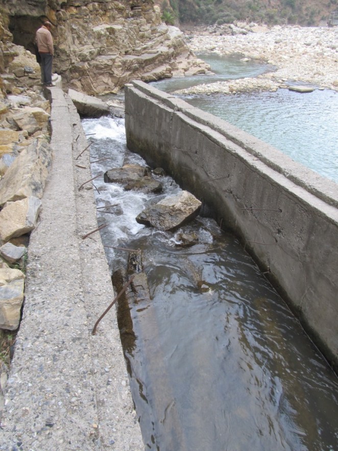
Being among the most recently completed, the Larji dam is the only dam on the Beas that has a fish-ladder, so it was of particular interest to us. Seeing no guard at the security booth, we walk in to the HPSEB dam operating office, and ask to speak to an officer about the fish ladder. To our complete surprise, we are spoken to and even taken on a tour of the ladder by a foreman who has worked on the dam for many years.
Having seen an elaborate fish ladder on the Kuri Chhu river in Bhutan of doubtful effectiveness[4], we could not help but look at this one with hope and excitement. Located at around 1,000 meters altitude, this dam was clearly in the way of a host of migratory species of fish. If this ladder design was effective, then surely the ‘barrier’ problem to seasonal migration for breeding and dispersal would have been addressed. Here though, is what we saw and heard.
For one, the flow through the fish-pass seems too small to create an ‘attraction flow’ for fish. But even more obviously, the downstream entrance of the fish ladder is a steep cascade over a couple of meters of broken masonry and rock, that would clearly be un-negotiable by any fish that does not jump that high[5].
Downstream entrance of Larji fish ladder: The 2 m high jump that fish require to enter the ladder can be seen here (all photos by the author)
2. The outlet from the dam reservoir into the fish ladder is blocked off by a metal grill-mesh that is narrow enough to trap flotsam like Bisleri water-bottles. The mesh seemed too fine to let Mahseer of breeding-age pass through, either upstream or downstream.
3. The fish ladder was in a serious state of disrepair. To our questions about whether the ladder worked or not, the foreman says honestly that it does not. We see the reasons for this when we walk down the ̴100 meter length of the fish-pass channel.
Fishladder can be seen in serious state of disrepair and blocked by broken concrete parts can be seen here
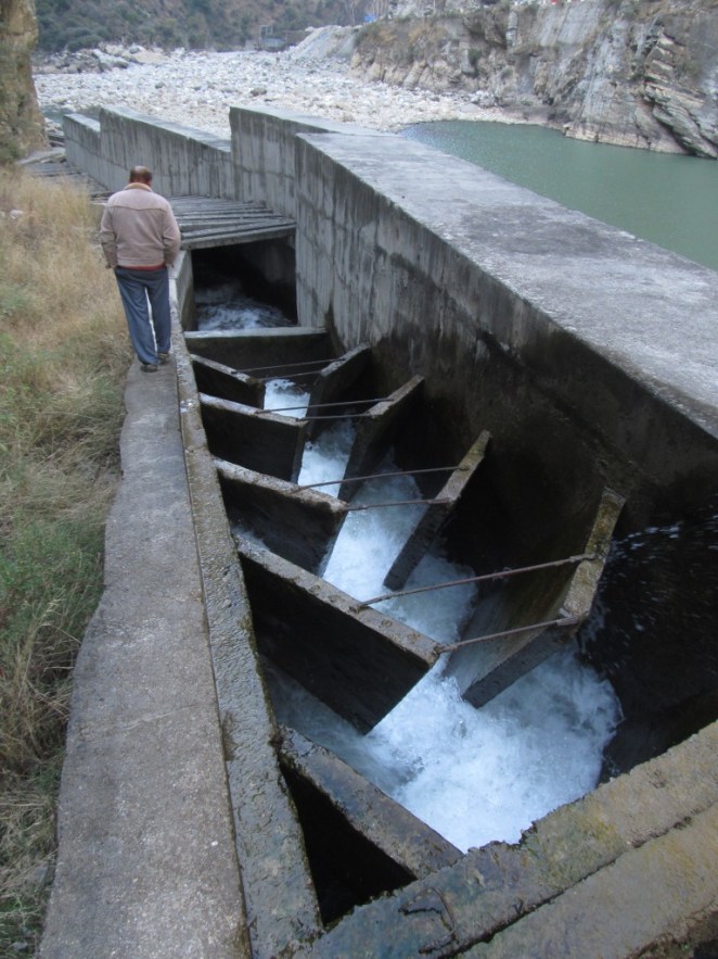
4. The Larji fish ladder seemed to be a hash of different designs of fish passes. There were four different design elements in this one fish-pass. It had a slotted-weir fishway design, a low gradient Denil fishway, a steep-pass Denil fishway and a plain concrete culvert on a grade design. Most of these slotted weirs were clogged with fallen rocks and debris from the slope above, and in places, the pools in them were over-flowing the weir in a vertical fall almost 2 meters high.
Steep-pass Denil fishway part of the fishladder can be seen here, water is flowing too rapidly here for any fish to be able to go upstream. The water picks up momentum down an extremely steep slope with the baffles at 45 degrees to the flow, not offset to slow the water, but concentrating the force of the water in mid-stream flow. The slope seemed to be at almost 40 degrees angle, and the water was turbulent in the extreme in this section. A workable Denilway slope, even for the strongest of swimmers among fish, is not designed to exceed a slope of 20% at most. This was close to a 100% slope
5. The oblique baffles on a Denil fishway are supposed to be placed in a manner that provides staggered partial-obstructions that slow the water down at variable velocities to make it passable for fish. However, here we saw that the water picks up momentum down an extremely steep slope with the baffles at 45 degrees to the flow, not offset to slow the water, but concentrating the force of the water in mid-stream flow. The slope seemed to be at almost 40 degrees angle, and the water was turbulent in the extreme in this section. A workable Denilway slope, even for the strongest of swimmers among fish, is not designed to exceed a slope of 20% at most. This was close to a 100% slope[6].
This part of fish ladder is less steep Denil
The last part of the fishway was a plain concrete culvert on a grade channel, essentially a sloping channel, where even the concrete sides of the channel had toppled over into the river-bed, and the final drop was over a two meter fall into the downstream flow. I asked the foreman whether he knew whether fish managed to make it over this extreme gauntlet. He said that they did not, but that he often saw fish gather and concentrate at the bottom of the dam under the sluice gates, and make futile leaps in an attempt to get over the dam. Clearly, the Larji dam fish ladder is just an unlovely trinket, a deceptive ornament.
Watch a 41 seconds video showing how fast the water is moving through the Larji Dam fishladder at: http://youtu.be/grVaxXPdeyY, Video is by the author.
It seemed to me that the dam builders and operators, the HPSEB in this case, both at the design and the executive levels, were not serious about constructing a fish-pass that would work, and neither were they serious about this at the operation and maintenance aspects. Whether they were serious at all even at the conceptual level, to put in place a mitigation measure that actually helped migratory fish bye-pass the barrier of the dam, or was this part of the design merely to obtain environmental clearance, can only be conjectured about. That hydropower projects can devise deceitful strategies for obtaining environmental clearance is one thing, but what does this tell us about the Union Ministry of Environment and Forests, the Expert Appraisal Committee on River Valley Projects appointed by MoEF, the regional office of the MoEF, the state Fisheries Department and also the state pollution Control Board, who are all variously part of the approval processes for hydropower projects, when they get their environmental clearances based on such ‘mitigation measures’?
Larji Dam – about 100 m long fishladder channel can be seen on the right side
[2] The 126 MW Larji project is also infamous for being the costliest hydro-power project per unit electricity generated so far in India. Finally built at a cost of R.s 10.27 billion, which was twice the estimated cost, the Vigilance department unearthed major financial misappropriation by HPSEB officials.
[5] Other than loaches, those tiny finger sized fish that can even climb (squiggle technique) up high waterfalls, provided there is something like a water-slide at the margins of the fall. They however, are not migratory fish.
[6] CIFRI recommends that the speed of flow of water in a fish-pass should not exceed 2 meters per second. Please see ‘Status of fish migration and fish passes with special reference to India’. MK Das and MA Hassan. CIFRI 2008.