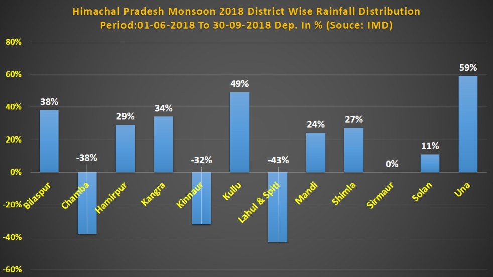
Himachal Pradesh has received 917.3 mm rainfall during South West Monsoon 2018. The amount is 11 percent higher than normal rainfall category of 825.3 mm. However at district level there is considerable variation in the distribution of rainfall. Out of 12 districts in the state, rainfall departure has been in deficit in three districts namely Chamba, Kinnaur and Lahul & Spiti by 38 percent, 32 percent and 43 per cent respectively. All these three districts are in upper part of Himalaya, the origin of many rivers & where mountains are mostly snow covered.
Tag: Rainfall
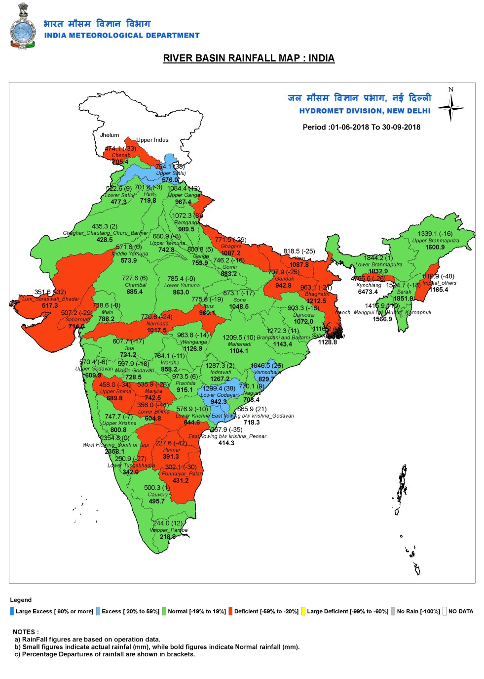
River Wise Rainfall in Monsoon 2018
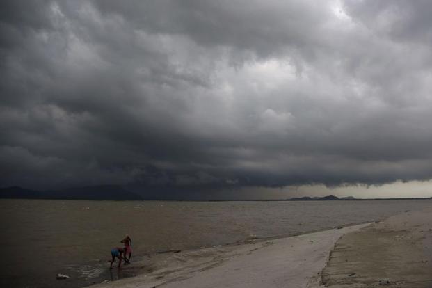
India’s most important season from water point of view, the June-Sept South West Monsoon has just ended officially on Sept 30, 2018. India Meteorological Department (IMD) reported that India received 804 mm rainfall in these four months of monsoon 2018, compared to normal rainfall of 887.5 mm. So Monsoon 2018 rainfall was 9.4% below normal, also proving IMD forecast wrong. Continue reading “River Wise Rainfall in Monsoon 2018”
Uttarakhand Monsoon 2018 Overview: Rainfall Normal, Distribution Abnormal
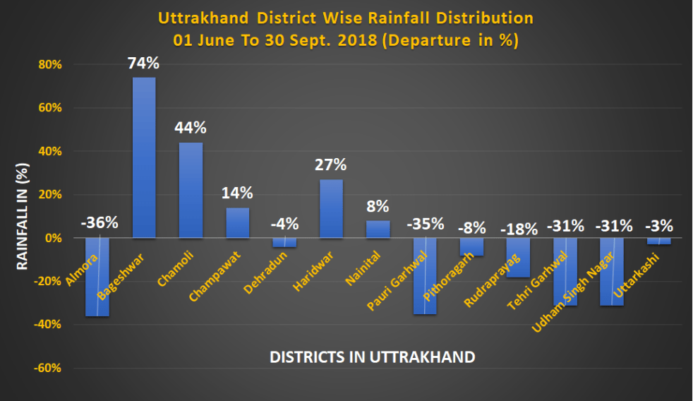
Uttrakhand has received 3% below normal rainfall during South West Monsoon 2018. Though the figure falls in normal category, however district level rainfall data paints a very different picture. Out of total 13 districts in the Himalayan state, four districts namely Almora, Pauri Garhwal, Tehri Garhwal and Udham Singh Nagar have received deficit rains, whereas three districts which includes Bageshwar, Chamoli and Haridwar have got rainfall in excess. Out of the rest six districts four are on marginally positive side and two are on marginally negative side.
Continue reading “Uttarakhand Monsoon 2018 Overview: Rainfall Normal, Distribution Abnormal”
The mirage of normal monsoon
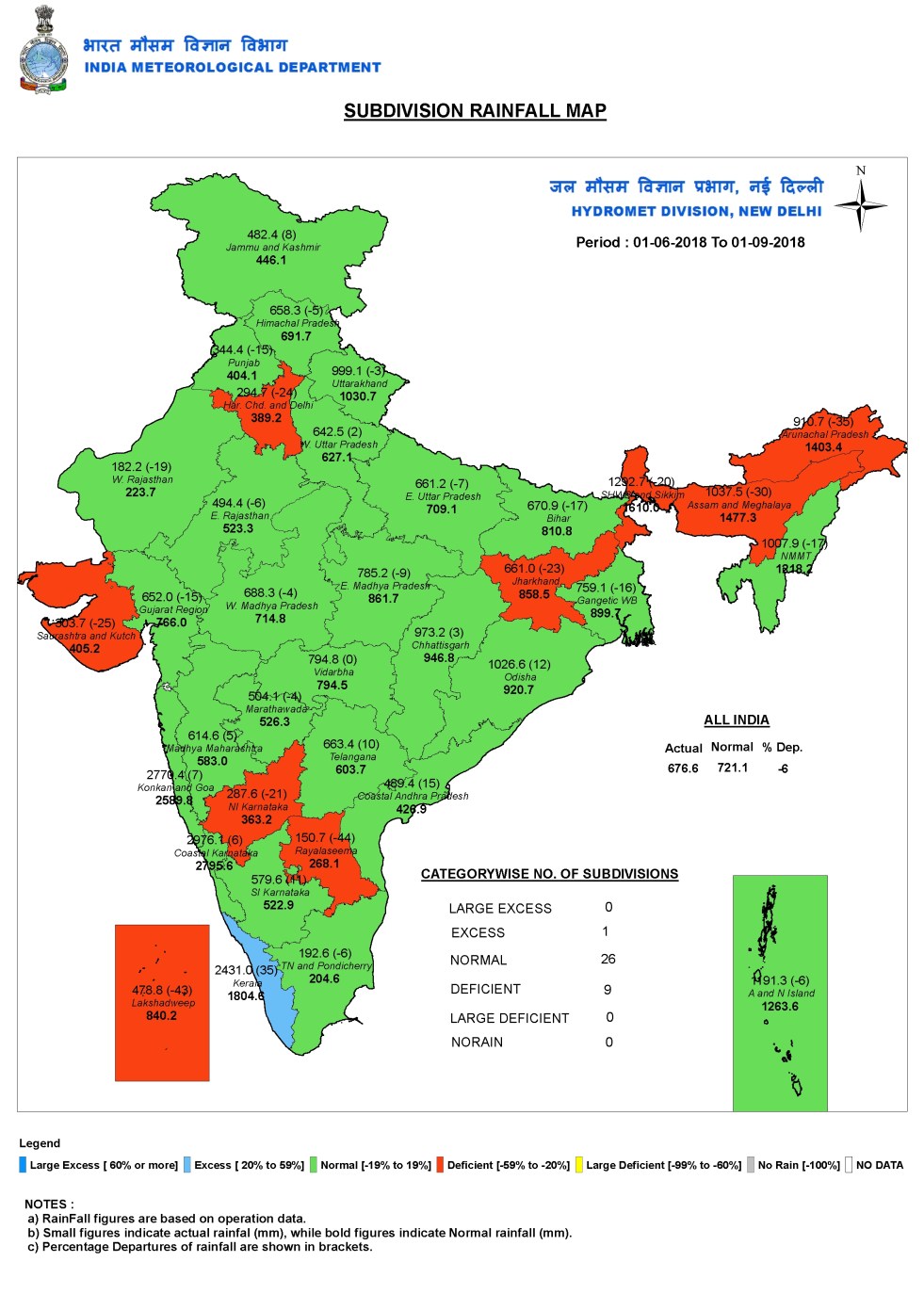
According to IMD, India is having normal monsoon this year, so far, as per rainfall till date (Sept 1, 2018). Against normal rainfall of 721.1 mm, India has received 676.6 mm rainfall, which is 6.2% below normal, considered within normal rainfall definition as per IMD. So India is having normal monsoon rainfall, says IMD. Let us check this against some ground realities.
However, East and North East India, one of the four regions for which IMD provides rainfall data, has so far had 27% below normal rainfall, while South India had 9% surplus rainfall. Thus, while at all India level, what seems all normal, is average of different, though serious departures from normal rainfall. Let us say this is first level of mirage of normal rainfall. Continue reading “The mirage of normal monsoon”

Uttrakhand Cloudburst Incidents 2018
Uttrakhand is a disaster prone State. Earthquakes, Forest Fires, Flash Floods and Landslides keep occurring here round the year. The cloud burst events have also made entry to the disaster list. During past many years, local people have gradually become familiar with the term CLOUD BURST. The freak weather incident seems striking the state in increased number and frequency year after year.
Midway through the 2018 monsoon, there have already been about a dozen cloud burst events across the state.
India Rivers Studies 2017: Rivers Succumbing To Dams, Pollution & Climate Change
After reviewing status of India rivers, SANDRP presents an account of research, studies and important reports on erratic monsoon, climate change, floods which all are severely affecting the rivers, their aquatic life and livelihood of dependent communities.
Rivers and Monsoon
Number of rainy days falling across river basins in India The study has found that number of rainy days is falling across river basins in India and rainfall intensities are seen to be increasing. The analysis determined changes in heavy precipitation and peak flood for seven river basins in India—Krishna, Godavari, Mahanadi, Narmada, Cauvery, Sabarmati and Brahamani and Baitarani. For the study, data pertaining to daily flows for about 30 odd years and precipitation for 61 years (from 1951 to 2012) were analysed.
The analysis also said the rivers which flow from west to east direction (in India) have more rainy days compared to those which flow towards the west. The study also held that anthropogenic activities (construction of storage reservoirs, diversions, urbanization, land-use change, and soil and water conservation measures, among others) have probably affected the generation of peak floods in the rivers of India. http://www.livemint.com/Politics/c7v8oXmsMDHIldjDv9k6lK/Number-of-rainy-days-falling-across-river-basins-in-India-s.html (Live Mint, 27 April 2017)
Continue reading “India Rivers Studies 2017: Rivers Succumbing To Dams, Pollution & Climate Change”
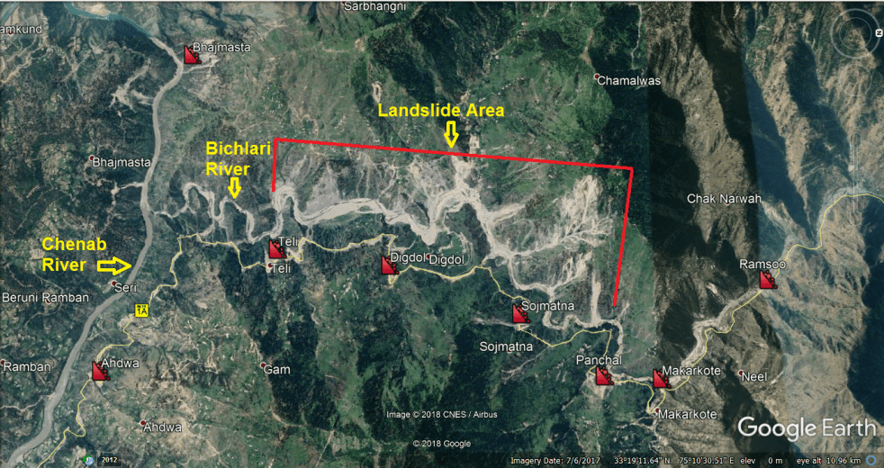
Why Jammu-Srinagar Highway Is So Landslide Prone?
Finally, after five days gridlock, the Jammu-Srinagar National Highway (NH-1A) has been opened to traffic, on Feb 17, 2018, but only for one side. The all weather road was closed since February 12, 2018 following landslides at multiple locations along Bichleri (Bichiari) stream (a tributary of Chenab River) between Banihal and Ramban area. The highway was briefly re-opened for traffic on February 14 only to be closed again on February 15, due to recurring landslides.
We have narrated below some details of the landslides along Jammu Srinagar Highway in Feb 2018 as well as earlier since 2011.
Continue reading “Why Jammu-Srinagar Highway Is So Landslide Prone?”

River Wise Rainfall in Monsoon 2017
India’s most important season, the June-Sept South West Monsoon has just ended officially on Sept 30, 2017. India Meteorological Department (IMD) reported that India received 841.3 mm rainfall in these four months of monsoon 2017, compared to normal rainfall of 887.5 mm. So Monsoon 2017 rainfall was 5.2% below normal.
The standard dominating reporting of monsoon rainfall figures in India is either state wise or sub division wise[i]. Accordingly, IMD reported that 25 sub divisions reported normal rainfall, 5 sub divisions[ii] reported excess rainfall and six sub divisions[iii] reported deficit rainfall, as can be seen from accompanying IMD sub division wise map of 2017 monsoon rainfall figures. Continue reading “River Wise Rainfall in Monsoon 2017”

Experimental Drought Monitor For India
Guest Blog by Prof Vimal Mishra (IIT Gandhinagar)
Introduction: Real-time drought monitoring and forecast in India is essential to support a large agricultural community. Prof. Vimal Mishra and his group (Water and Climate Lab) developed a real-time drought monitoring platform for India. The system provides conditions based on meteorological (rainfall based), hydrological (runoff based), and agricultural (soil moisture based) droughts and updates everyday. The products are based on real-time satellite rainfall, which was corrected using the long-term climatology from the India meteorological department (IMD). Runoff and root zone soil moisture are simulated using a well evaluated hydrologic model. All the drought products are extensively verified against other drought indicators such as satellite based drought severity index. Further information on monitor can be obtained in Shah and Mishra (2015). Continue reading “Experimental Drought Monitor For India”
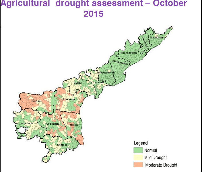
Andhra Pradesh Drought 2016
On Oct 28, 2015, the Andhra Pradesh government declared 196 mandals in seven districts, as drought-affected during the Kharif season 2015. The districts were Srikakulam (10 mandals), Prakasam (21), Nellore (14), Chittoor (39), Kadapa (33), Anantapur (39) and Kurnool (40). Consequent to the declaration of drought, the government directed the concerned district Collectors to notify the specific drought-hit areas in the District Gazette to enable farmers to avail credit facilities. On Nov 22, 2015, the Govt. added 163 mandals to the list of drought hit bringing the number up to 359 mandals. This included mandals in Guntur, Krishna, Vizianagaram. Drought was declared in 10 out of 13 districts. Crop loan and relief measures were to be taken up in these mandals as per guidelines. The state demanded central assistance of Rs 2,000 crore.
