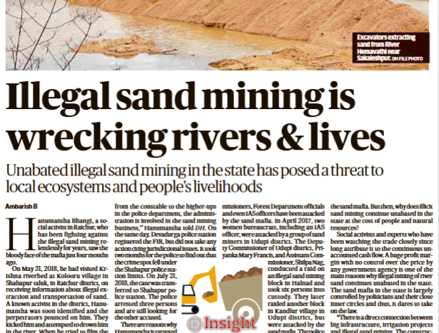
Andhra Pradesh · Water Resources Information System

APWRIMS: Impressive Water Information System of Andhra Pradesh

Andhra Pradesh Water Resources Information and Management System[i] is truly impressive water information system, possibly not available in any other state or even at national level, at any time in India. The comprehensiveness of the water information system is striking, as it not only includes reservoir water storages of Major and Medium Projects, but also storages in minor projects, minor tanks, water conservation structures (check dams, percolation tanks) but also groundwater and most importantly, soil moisture. These are collected in real time from diverse information sources including on ground measurements, satellite based assessments and also sent via mobile apps from diverse sources. And the information is put out in real time, along with number of analysis. The data are collated and analysed using tools from Vassar Labs, like Machine learning, Artificial Intelligence and big data. Continue reading “APWRIMS: Impressive Water Information System of Andhra Pradesh”

Dams

CWC Flood Forecasting: Anomalies between Website and SOP Document

Central Water Commission (CWC) is the only agency in India doing flood forecasting, it becomes very important to understand what CWC does in this regard. The CWC flood forecasting website[i] is the main media through which CWC provides the flood forecasting. CWC has also published on its website, the document giving Standard Operating Procedure (SOP) for flood forecasting in 2018[ii]. The Home page of the CWC’s flood forecasting site says that CWC provides Level forecasting for 166 sites and Inflow forecasting for 60 sites. SOP document, however, gives these figures in Table 1, but in Table 2 (as also the full list given in Annexure 1.1 of SOP document), it gives state wise break up for 182 Level forecasting and 93 Inflow forecasting sites. So we can see anomalies in these two sources even about the number of forecasting sites.

Continue reading “CWC Flood Forecasting: Anomalies between Website and SOP Document”

Dams · Floods

Overview of CWC Flood Monitoring Sites 2018: INDIA

Central Water Commission is the only agency doing flood forecasting in India. As per CWC’s Flood Forecasting website[i] the Data Flow Map has information about 226 Flood Forecast Sites in the country comprising of 166 Level Forecast Sites and 60 Inflow Forecast Sites. It also monitors 700 Flood sites, information made available through List Based Exploration and Hydrograph View, but no flood forecasting is done for these sites.

In order to better understand the CWC’s flood monitoring and forecasting work, SANDRP has published report of CWC’s Level Forecast, Inflow Forecast and level monitoring sites in 5 zones of North India[ii], North East India[iii], East India[iv], South India[v] and West India[vi].  Through this report, we have presented all the data at one place with links to separate zone wise reports with detailed description.

Continue reading “Overview of CWC Flood Monitoring Sites 2018: INDIA”

Dams · Floods

Overview of CWC Flood Forecasting Sites 2018: WEST INDIA

Central Water Commission is the only agency doing flood forecasting in India. As per CWC’s Flood Forecasting website[i] the Data Flow Map has information about 226 Flood Forecast Sites in the country comprising of 166 Level Forecast Sites and 60 Inflow Forecast Sites. It also monitors 700 other sites, information is made available through List Based Exploration and Hydrograph View, but no flood forecasting is done for these sites.

In order to better understand the CWC’s flood monitoring and forecasting work, in this article, we have given an overview of CWC’s flood forecasting and monitoring sites in West India. It includes state wise list of CWC’s Level Forecasting, Inflow Forecasting and level monitoring sites in 5 States in West India. Similar report has been published for North India[ii] and North East India[iii] and East India[iv] and South India[v]. This is the last part in the series.  Continue reading “Overview of CWC Flood Forecasting Sites 2018: WEST INDIA”

Dams · DRP News Bulletin

DRP: 13 August 2018: Existing Sediment Management Draft Policy Promoting Navigation & Not Rivers’ Health

Traditionally, our river management strategies are mainly focused on the water flows, including flood management, and these have resulted in various interventions such as dams, barrages, canals and embankments. Most of these interventions have had very little consideration for sediment transfer and even if they did, they were generally defunct within a few years of their operations either due to improper design or inadequate maintenance.

A long-term sediment management strategy has never been a part of any protocol of river management, not just in India, but in several other parts of the world. It is amply clear that sediment management must form an important component of management strategies for the Himalayan rivers. The Union Water Ministry has recently circulated a draft policy on sediment management.

Continue reading “DRP: 13 August 2018: Existing Sediment Management Draft Policy Promoting Navigation & Not Rivers’ Health”
Dams, Rivers & People

DRP: 30 July 2018: Laos Dam DISASTER: Yet Another Wake Up Call?

The various aspects of tragic Dam Disaster in Mekong Basin in Laos are still unfolding. But it is clear from many accounts that it was an avoidable, man-made disaster due to neglect of contractors, decision makers, consultants and supervising agencies. There is a lot we can learn from this if we want to avoid such disasters in India. We still do not have credible Dam Safety Law or institution, CWC is clearly not the right agency considering the conflict of interest with the various other roles of CWC. But for now let us look at the reports of Laos Dam Disaster.

Reminding the world of one of the worst dam disasters, the under construction dam Xepian Xe Nam Noy Hydro power project breached releasing 5 billion cubic metres of water in Southern Laos on July 23.

The gushing water current swept the surrounding leading to death of about 26 people and displacing about 6600 residents. As per report hundreds of people are still missing from neighbouring villages of Yai Thae, Hinlad, Mai, Thasengchan, Tha Hin, and Samong, which bore the brunt of flooding. The deluge has reportedly destroyed thousands of homes.

Continue reading “DRP: 30 July 2018: Laos Dam DISASTER: Yet Another Wake Up Call?”
Dams · DRP News Bulletin

DRP: 2 July 2018: Punjab Cabinet Meets To Discuss Water crisis

In a rare event, Punjab Cabinet met to discuss water crisis on June 26, 2018. The reports before the meeting seemed to give hope that may be Punjab will look at the water crisis in a fundamental, holistic way. https://indianexpress.com/article/cities/chandigarh/punjab-government-to-firm-up-water-conservation-plan-5233826/ (June 26, 2018)

But the cabinet ended up setting up a committee to assess the ground water situation in the state and submit a detailed proposal for water conservation.

– Punjab has the highest rate of groundwater exploitation and had on average withdrawn 28.2 million acre feet (MAF) water yearly during 2008-2013. However, the yearly average replenishment of water was only 18.9 MAF.

– 73% of Punjab’s irrigated area uses groundwater for irrigation, while only 27% uses surface water. The number of tubewells had gone up exponentially from 2 lakh in 1971 to 12.50 lakh in 2015-16, with 41% of these have water availability beyond the depth of 60 metres. https://timesofindia.indiatimes.com/city/chandigarh/5-member-committee-to-assess-punjab-ground-water/articleshow/64770186.cms  (28 June 2018)

Continue reading “DRP: 2 July 2018: Punjab Cabinet Meets To Discuss Water crisis”
Dams · DRP News Bulletin

DRP: 11 June 2018 (Groundwater Pollution: The Hidden Killer Menace Lurking All Over)

Aquifers in 16 States in the country are contaminated by uranium, whose presence in drinking water has been linked to chronic kidney disease by several studies, a recent study has shown. More importantly, uranium doesn’t figure on the list of contaminants monitored under the Bureau of Indian Standards’ drinking water specifications. The main source of this contamination is natural, but groundwater depletion by extensive withdrawal of water for irrigation and nitrite pollution due to the excessive use of nitrogenous fertilisers may be exacerbating the problem, said the study.

– The study was carried out by a team of researchers led by Avner Vengosh, professor of geochemistry and water quality at the Nicholas School of the Environment at Duke University in the US. The team, which also included experts from the Central Ground Water Board, the Rajasthan government’s Ground Water Department and Gujarat Water Resources Development Corporation, analysed groundwater samples from 226 locations in Rajasthan and 98 in Gujarat.

Continue reading “DRP: 11 June 2018 (Groundwater Pollution: The Hidden Killer Menace Lurking All Over)”
DRP News Bulletin

DRP: May 7, 2018: WESTERN GHATS FORESTS ARE VITAL FOR SOUTH WEST MONSOON RAINS IN TAMIL NADU

W Ghats Forests vital for Tamil Nadu SW Monsoon Rains Researchers have found that the dense vegetation in the Western Ghats determines the amount of rainfall that Tamil Nadu gets during the summer monsoon. A team led by Prof. Subimal Ghosh from the Department of Civil Engineering at the Indian Institute of Technology (IIT) Bombay has found that dense forests of the Western Ghats contribute as much as 40% of moisture to the southwest monsoon rainfall over Tamil Nadu during normal monsoon years. The average contribution is 25-30%. But during monsoon deficit years, the contribution increases to as high as 50%.

Continue reading “DRP: May 7, 2018: WESTERN GHATS FORESTS ARE VITAL FOR SOUTH WEST MONSOON RAINS IN TAMIL NADU”
DRP News Bulletin

DRP: 16 April 2018: HOW Citizens can use mobile app to monitor Rivers

MOBILE APP FOR RIVER MONITORING: HUGE POTENTIAL FOR CITIZENS IN INDIA? If you added up the length of all the streams around the world, the total would be at least 89 million kilometers [Downing et al., 2012]. More than half of the global stream channel network is likely intermittent (i.e., the streams do not have flow year-round [Datry et al., 2014]), yet most streamflow monitoring stations are located on perennial streams.

Continue reading “DRP: 16 April 2018: HOW Citizens can use mobile app to monitor Rivers”