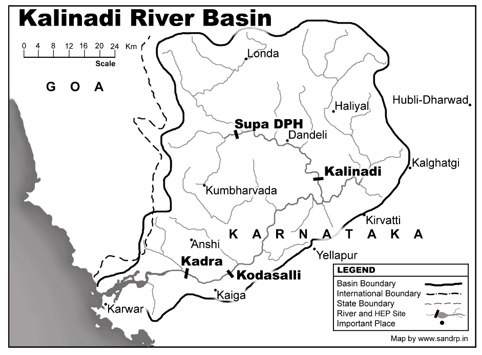
The New Indian Express published a most remarkable report on Aug 24, 2019[i]. It said, among other things: “The district administration of Uttara Kannada will seek an inquiry report from the managing director of Karnataka Power Corporation Limited on untimely release of water from Kadra dam to Kali River, which caused flood in Kadra, Mallapur, Kaiga township, Hanakon, Kharge Jooga island, Kinnar, Siddar, Vailawada and many villages in Karwar taluk in the first week of August. 5,000 people from these villages were shifted to rehabilitation centres in Karwar and other villages. Half of the Kaiga township was inundated and employees of Kaiga Atomic Power Station had to use boats to reach the nuclear power plants… The district administration was not informed about the increasing inflow into Kadra dam and outflow into the river. Finally, DC Harish Kumar K, ZP CEO M Roshan and then SP Vinayak Patil camped in Kadra and took over the control of the dam due to the failure of dam officials. They managed the outflow of the dam for a couple of days. Deputy Commissioner Harish Kumar K said the district administration will write to KPCL MD seeking an inquiry on water released from dams to Kali river.” Continue reading “Unprecedented Dam flood situation in Uttara Kannada in Aug 2019”
Tag: flood disaster
Western Japan floods 2018: Hiroshima and the Summer of the Deluge
Guest blog by Aparna Datar
Hiroshima Hiroshima’s moral grip on our consciousness extends, beyond the Hiroshima Peace Dome, straight to the heart of India’s most urgent problem. The problem of balancing urbanization, growth, floods, and droughts in the face of climate change.
In the summer of 2018 devastating floods and landslides (blamed upon climate change) ravaged western Japan. With an unusually high death toll, for a nation that is used to counting the collateral damage more in terms of economic loss, than in terms of human lives, this one left a tragic number of people dead. Floods washed away large parts of Hiroshima, Kyoto, Okayama and Ehime. I joined Prof. Moe Nakazora, an anthropologist with the University of Hiroshima on a study tour of two of the worst affected villages in the eastern part of Hiroshima. These were the villages of Hachihonmatsu and Kouchi. Both the villages are located in Higashihiroshima which had more than 2000 landslides.[i] Continue reading “Western Japan floods 2018: Hiroshima and the Summer of the Deluge”
Dams Floods 2018: Filling up Dams well before Monsoon end, Invitation to Disaster
The tendency of filling up reservoirs in the beginning and middle of monsoon season have been leading to avoidable flood disasters in the country. Apart from Kerala flood 2018, which was aggravated by mismanagement of reservoirs, various reports show that reservoirs in river basin of Cauvery, Krishna, Godavari and Ganga were also filled up well before the end of South West monsoon season. Resultantly there were many man made flood spells in downstream areas affecting lives and livelihoods of people.
After highlighting role of dams in floods in Kerala and how improper dam operation affected people in Assam and Himachal Pradesh, this third and concluding part throws light on other dam induced flood (and canal breach) incidents in 2018. Continue reading “Dams Floods 2018: Filling up Dams well before Monsoon end, Invitation to Disaster”

Dam Floods 2018: Assam, Himachal; Making Dam Operators Accountable
ASSAM: NEEPCO a repeat offender? On July 27, 2018 sudden release of water from NEEPCO’s Doyang Hydropower Electric Project (HEP), located in Wokha district, Nagaland led to flood disaster[1], submerging[2] about 36 villages in Golaghat a district in Upper Assam. According to Rony Rajkumar, project officer of the Golaghat district disaster management authority, around 5,575 people were affected by the deluge which damaged 887.9 ha of crop.
Earlier, on July 11, 2018, reviewing the severe flood situation Lakhimpur Assam, the Chief Minister (CM) Sarbananda Sonowal strongly warned[3] the state-owned power utility NEEPCO not to release water from its Ranganadi dam without warning like previous years.
Continue reading “Dam Floods 2018: Assam, Himachal; Making Dam Operators Accountable”
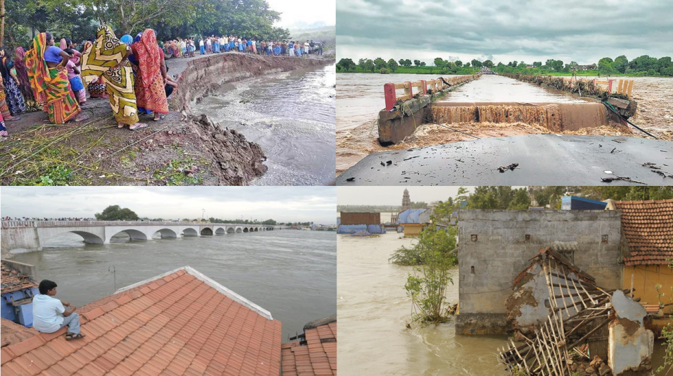
Kerala: Dams Floods 2018: Follow Rule Curves to Avoid Flood Disasters
Unprecedented Kerala deluge[1] that swept through the coastal state on the day of Independence day 2018 was most disastrous flood incident in the year. It has also been termed as one the worst flood in the state and reminded the people of July 1924 and July 1962 flood calamities. Many experts, several reports and studies have established the role of dams in worsening the deluge. According to reports, 35 out of the 46 dams within the state were opened for the first time in history[2]. All 5 overflow gates of the Idukki Dam were opened at the same time, for the first time in 26 years.
State Government Accepts Dams Role
Kerala is usually considered a flood-proofed[3] state with its undulating terrain. For a state that receives an annual average rainfall of nearly 3,000 mm, its natural landscape protects it from recurrent floods. Indeed, the Kerala flood has highlighted our poor dam management[4] system.
As per officials the crisis could have been contained[5] had the state “gradually released” water from at least 30 dams, in advance of high rainfall, adding that local authorities failed to foresee the imminent danger with high rain predictions. “Such floods have probably recurred after 100 years, exposing the State’s unprofessionally run reservoirs management system and unpreparedness on disaster mitigation and disaster resilience.
Continue reading “Kerala: Dams Floods 2018: Follow Rule Curves to Avoid Flood Disasters”
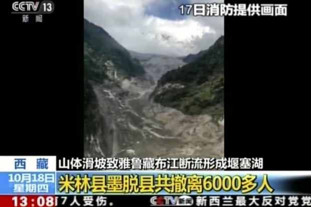
Landslide DAM on Tsangpo creates flood disaster risk for Siang
A massive dam, created by landslide in early hours (around 5 am) of Oct 17,2018 has blocked the main stream of Yarlung Tsangpo in Tibet. The reservoir behind the dam already has humungous 360 Million Cubic Meters (MCM) of water by 7 am on Oct 18, 2018 and as per latest reports (subsequently saw the CWC tweet put out at 955 pm on Oct 18, saying that storage had reached 484 MCM by 8 pm on Oct 18), the reservoir is still growing in size. The exact location of the landslide dam is uncertain. According to one source, the latitude longitude could be 94.93754° E, 29.74957° N, but this may not be accurate the likely location may be a few kilometers downstream from here. The Chinese media[i] has reported that the landslide dam is located at near Gyalha village in Milin or Manling county. According to some experts who visited the site, the dam could breach very soon, possibly on Oct 19, bringing massive floods along Siang river in Arunachal Pradesh. Continue reading “Landslide DAM on Tsangpo creates flood disaster risk for Siang”

Prime Minister Modi at Kedarnath: What was said; what was left unsaid
The central theme of Prime Minister Narendra Modi ji’s 40 minutes speeach at Himalayan pilgrimage centre of Kedarnath in Uttarakhand on Oct 21, 2017[i], was that we need to come out of the shadow of a disaster. It was to chart out new design, development and reconstruction of the temple, the road, the banks of River Mandakini and its tributary Saraswati and the memorial of Shankaracharya. The reconstruction was required since the disaster had destroyed all this and more. Continue reading “Prime Minister Modi at Kedarnath: What was said; what was left unsaid”
दो बाॅधों की कहानीः क्या बिहार की अप्रत्याशित बाढ़ एक टाली जा सकने वाली मानव जनित त्रासदी है?
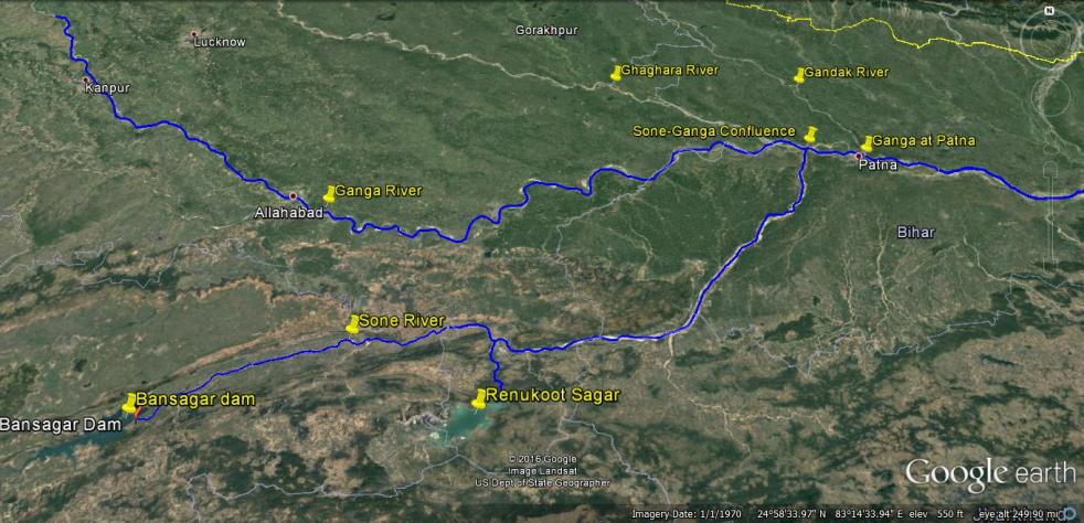
बाणसागर बाॅध, सोन नदी, गंगा नदी और पटना को दर्शाता मानचित्र
21 अगस्त 2016 की सुबह, गंगा नदी का जलस्तर लगातार बढ़ते हुए, पटना में 50.43 मीटर पर पहुॅच गया। जिससे पटना में गंगा नदी अपने पहले के उच्चतम बाढ़स्तर 50.27 मीटर से 16 सैंटीमीटर ऊपर बह रही थी। 22 अगस्त 2016 तक पानी का जलस्तर गंगा नदी के किनारे तीन अन्य स्थानों पर उच्चतम बाढ़स्तर को पार कर गया। जिसका विवरण निम्न हैः-
स्थान 22.08.2016 को उच्चतम बाढ़स्तर पुराना उच्चतम बाढ़स्तर
बलिया उत्तरप्रदेश 60.30 मीटर 60.25 मीटर (14 सितंबर 2003)
हाथीदाह, बिहार 43.17 मीटर 43.15 मीटर (07 अगस्त 1971)
भागलपुर बिहार 34.55 मीटर 34.50 मीटर (05 सितंबर 2013)
इस तरह से हम देखते हैं कि पटना में उच्चतम बाढ़ का रिकार्ड तोडने के बाद, अब यह बाढ़ गंगा नदी के किनारे बसे बिहार और उत्तरप्रदेश के अन्य इलाकों में पहुॅच रही है। यहाॅ यह बात उल्लेखनीय है कि बिहार में अब तक वर्षा औसत से 14 प्रतिशत कम हुई है। सवाल यह उठता है कि इसके बावजूद गंगा में रिकार्ड तोडने वाली बाढ़ क्यों आयी?

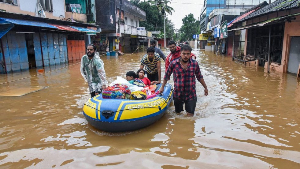
CHENNAI FLOODS: Cities today, countryside tomorrow?
Above: Chennai International Airport & the Adyar river
GUEST BLOG by: Manoj Misra (yamunajiye@gmail.com)
Chennai is going through the same hell today that Mumbai did in July 2005, Surat in August 2006, Ambala and Moradabad in 2010 and Srinagar and Guwahati in September 2014. High rainfall event and the waters’ inability to leave the city harmlessly, flooding houses (many built by the state housing boards), offices, commercial establishments, roads, railway lines and even the airport and the resulting misery for residents, travelers, industry, commerce and the tourists alike. Continue reading “CHENNAI FLOODS: Cities today, countryside tomorrow?”
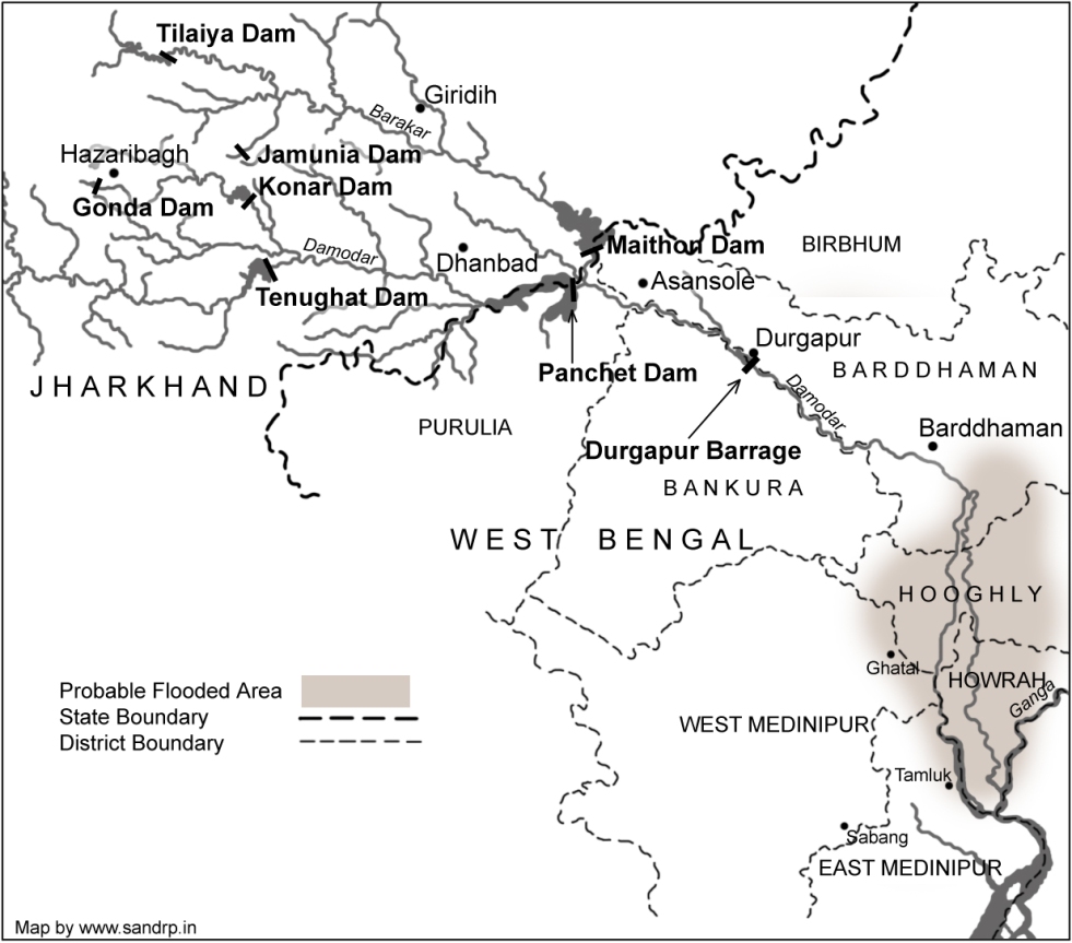
Damodar Valley Dams role in W Bengal Floods – DVC Dams could have helped reduce the floods, they increased it
As at least 222 blocks of 13 districts of South Bengal suffered massive floods with over 51 lakh people affected and crops on 5 lakh hectares ruined, questions have once again been raised if Damodar Valley Corporation[1] dams played a role in increasing this flood disaster. Available information and the statements of the DVC officials leave no doubt that DVC dams indeed released water into the rivers and this release worsened and prolonged the flood situation in South Bengal. If DVC had held back the water while cyclone Komen was active in the region, bringing heavy rains, then the flood intensity, its impact area and the flood duration could have been reduced. The DVC operators should also have kept in mind that this was high tide period when the rivers’ capacity to drain out the water was significantly lower in the delta area. The DVC dams had sufficient storage capacity to hold this water during the period. However, instead of holding back the water during this crucial period, DVC increased water releases from the dams during the flood disaster. Continue reading “Damodar Valley Dams role in W Bengal Floods – DVC Dams could have helped reduce the floods, they increased it”
