Dams · Floods

Overview of CWC’s Flood Forecasting Sites 2018: North East India

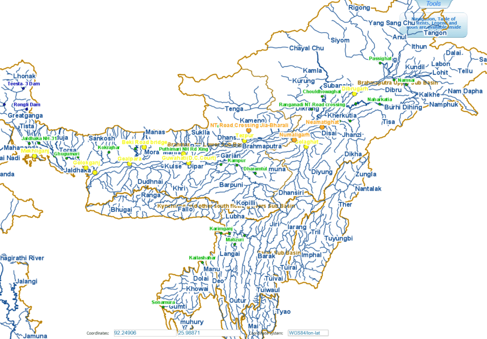
Central Water Commission (CWC) measures and monitors water level at 700 hundred Flood Forecasting site in the country. It publishes this information on its Flood Forecast website[I]. The website has three ways to get this information: Data Flow Map, List Based Exploration, and Hydrograph view. The Hydrograph view provides information for past 72 hours, supposed to be updated every hour. This is in addition to the list of current forecasts.

As per the website the Data Flow Map has information about 226 Flood Forecast Sites in the country comprising of 166 Level Forecast Sites and 60 Inflow Forecast Sites. It also monitors 700 Flood sites, information made available through List Based Exploration and Hydrograph View.

In order to better understanding the CWC’s flood monitoring and forecasting work, in this article we have given state wise list of CWC’s Level Forecast, Inflow Forecast and level monitoring sites in North East India. For better understanding, we have also included part of West Bengal that is in Brahmaputra basin here, in addition to the 8 North Eastern states. Similar report has been published for North India[II] and we hope to publish reports covering other regions of India too.

Continue reading “Overview of CWC’s Flood Forecasting Sites 2018: North East India”

Bihar · Dams · Floods · Ganga

Will sluggish Farakka again create prolonged floods along Ganga in Bihar?

It’s a bit intriguing situation. IMD and Skymet experts are downgrading the monsoon rainfall from earlier forecast 100% to 92%. Both agencies are predicting even lower rainfall in remaining part of current South West Monsoon.  Bihar has received 413.2 mm rainfall till Aug 2, 2018, 22% below normal. And yet, starting Aug 1, CWC’s flood forecasting sites along the Ganga were showing ominous portents. For the first time this monsoon, the sites started showing steep upwards trend. Continue reading “Will sluggish Farakka again create prolonged floods along Ganga in Bihar?”

Dams · Floods

Overview of CWC Flood Forecasting Sites 2018: North India

Flood forecasting is an important activity during monsoon, considering the huge and increasing flood prone area, flood frequency, extent and flood damages. Accurate and timely flood forecasting can hugely help reduce the damages due to floods. Central Water Commission (CWC) is the only agency responsible for flood forecasting in India. To understand the CWC’s flood forecasting better, we have compiled the list of the various flood, inflow forecasting sites and flood monitoring sites in India.

In this compilation, we have given state wise list of CWC’s flood forecasting, flood monitoring and inflow forecasting sites, along with available details like rivers, sub basin, river basin, Warning level, Danger Level, High Flood Level, Full Reservoir Level, Maximum Water Level. As we see below, there are many gaps in this basic information for the sites that are part of CWC’s list.

Continue reading “Overview of CWC Flood Forecasting Sites 2018: North India”

Dams, Rivers & People

DRP: 30 July 2018: Laos Dam DISASTER: Yet Another Wake Up Call?

The various aspects of tragic Dam Disaster in Mekong Basin in Laos are still unfolding. But it is clear from many accounts that it was an avoidable, man-made disaster due to neglect of contractors, decision makers, consultants and supervising agencies. There is a lot we can learn from this if we want to avoid such disasters in India. We still do not have credible Dam Safety Law or institution, CWC is clearly not the right agency considering the conflict of interest with the various other roles of CWC. But for now let us look at the reports of Laos Dam Disaster.

Reminding the world of one of the worst dam disasters, the under construction dam Xepian Xe Nam Noy Hydro power project breached releasing 5 billion cubic metres of water in Southern Laos on July 23.

The gushing water current swept the surrounding leading to death of about 26 people and displacing about 6600 residents. As per report hundreds of people are still missing from neighbouring villages of Yai Thae, Hinlad, Mai, Thasengchan, Tha Hin, and Samong, which bore the brunt of flooding. The deluge has reportedly destroyed thousands of homes.

Continue reading “DRP: 30 July 2018: Laos Dam DISASTER: Yet Another Wake Up Call?”
Dams · Yamuna River

Floods & Flood Monitoring in Yamuna: July 2018

The release of around 1.31 lakh cusecs of water in Yamuna from Hathnikund barrage at 09:00 hours on July 26, 2018, was certainly first surge of flood this monsoon in the river. But no one expected, most are still in the dark that the release would multiply by over five times in just two days! It is almost a month after the Southwest monsoon arrived. By this time the river usually floods couples of times.

Looking at the lack of significant rainfall in the catchment area over past weeks, the flood is unexpected and has taken many by surprise. The Irrigation and Flood Control Department, Delhi Government has issued warning for flood plain farmers and human settlements close to river banks, but the warning does not seem to commensurate with the flood peak that is likely to hit the capital in next day or two.

23 Yamuna Flood Chart 1963-2016
Bar chart by Irrigation & Flood Control Dept, Delhi showing history of floods in Yamuna river since 1963.

Yamuna has already crossed warning (204 m) and danger level (204.83) at Old Delhi Railway Bridge (ORB), Delhi. The High Flood Level is 207.49 meters, reached on Sept 6,1978 after around 7 lakh cusecs (cubic feet per second) water was released in Yamuna on 3rd Sept 1978 at 04:00 hrs from Tajewala barrage, that was decommissioned and replaced by Hathnikund barrage in early 1990s. The flood monitoring of River Yamuna began in 1963.

Since then, the river has seen high floods in 1988, 1995, 2010 and 2013. The 2010 and 2013 floods also crossed 207 metres mark but fell short of 1978 level.

Continue reading “Floods & Flood Monitoring in Yamuna: July 2018”

Cauvery · central water commission · Dams · Disasters · Floods · Karnataka · Tamil Nadu

Cauvery is facing very serious flood risk, but CWC is in slumber

(The figure above is screen shot of CWC Flood forecasting site showing no warning signs even at 5 pm on 230718)

Almost all the big dams in Cauvery Basin are full on the earlier ever monsoon date this year. This includes Krishnaraj Sagar, Mettur, Kabini, Harangi, Hemavathi and Bhavanisagar. They are almost full and have started releasing large flows to the downstream areas. This is when we are past just about six weeks of South West Monsoon, the North East monsoon would come after that. It means that the basin is facing major risk of floods in next 2-5 months. And yet Central Water Commission, India’s flood forecasting agency, seems to be in deep slumber. It has not even bothered to update the flood readings on its designated sites from the 2017 figures.  Continue reading “Cauvery is facing very serious flood risk, but CWC is in slumber”

Dams · DRP News Bulletin

DRP: 23 July 2018: Landmark CAG Reports on DAM FLOODS & Ineffective; Costly Mega Irrigation Projects

In its latest report, the Comptroller and Auditor General (CAG) has questioned implementation of sixteen National Irrigation Projects. Before this, the CAG has held mismanagement in dams’ operation responsible for Chennai floods in 2015. Both these reports are available on its website now.

The CAG report on National Irrigation Projects, tabled in Parliament on July 20, has revealed that sixteen major multi-purpose water projects, taken up on an expeditious basis about a decade ago, are nowhere near completion, with no work being undertaken in as many as 11 projects despite the incumbent govt’s much-wanted focus on improving irrigation facilities in the country.

The report also mentioned that out of the 16 projects, undertaken under the Accelerated Irrigation Benefits Programme (AIBP) in Feb 2008, only five projects with estimated irrigation potential of 25.10 lakh hectares were under implementation and even these projects suffer from 8 to 99 per cent shortfall in physical progress, the CAG said. The remaining 11 projects with estimated irrigation potential of 10.48 lakh hectares are yet to commence and are at different stages of approval.

Continue reading “DRP: 23 July 2018: Landmark CAG Reports on DAM FLOODS & Ineffective; Costly Mega Irrigation Projects”
Dams · DRP News Bulletin

DRP: 2 July 2018: Punjab Cabinet Meets To Discuss Water crisis

In a rare event, Punjab Cabinet met to discuss water crisis on June 26, 2018. The reports before the meeting seemed to give hope that may be Punjab will look at the water crisis in a fundamental, holistic way. https://indianexpress.com/article/cities/chandigarh/punjab-government-to-firm-up-water-conservation-plan-5233826/ (June 26, 2018)

But the cabinet ended up setting up a committee to assess the ground water situation in the state and submit a detailed proposal for water conservation.

– Punjab has the highest rate of groundwater exploitation and had on average withdrawn 28.2 million acre feet (MAF) water yearly during 2008-2013. However, the yearly average replenishment of water was only 18.9 MAF.

– 73% of Punjab’s irrigated area uses groundwater for irrigation, while only 27% uses surface water. The number of tubewells had gone up exponentially from 2 lakh in 1971 to 12.50 lakh in 2015-16, with 41% of these have water availability beyond the depth of 60 metres. https://timesofindia.indiatimes.com/city/chandigarh/5-member-committee-to-assess-punjab-ground-water/articleshow/64770186.cms  (28 June 2018)

Continue reading “DRP: 2 July 2018: Punjab Cabinet Meets To Discuss Water crisis”
Assam · Floods

Floods in Tripura, Mizoram, Barak Valley in June 2018

The second wave of floods (first wave came in around May 20-24) this year inA North East India is affecting Tripura, Mizoram and mainly Barak Valley in Assam. Worryingly, while CWC flood forecast site shows water level reaching unprecedented levels in Manu river at Kailashahar in North Tripura District, CWC seems to have NO flood forecasting site in Mizoram. At Matizuri site in Hailakandi district in Barak Valley in Assam, the Katakhal river also approaching its highest ever flood level. In Bangladesh too sites like Amalshid have crossed the HFL.  Continue reading “Floods in Tripura, Mizoram, Barak Valley in June 2018”

Disasters · Floods

CWC’s Weekly Reservoir Bulletin: Closer look warns of impending disaster

One of the key source of information about India’s water availability that the government provides and media and everyone else quotes is Central Water Commission’s weekly (updated every Thursday) “Reservoir Storage Bulletin”[i]. The Reservoir Storage Bulletin (RSB) currently tells about water storage position of 91 storage dams across India with total live storage capacity of 161.993 BCM (Billion Cubic Meters), spread over 18 states and 12 river basins. CWC uploads it with a disclaimer: “The Data contained in this Bulletin is as received from the State Government/Project Authorities.” Continue reading “CWC’s Weekly Reservoir Bulletin: Closer look warns of impending disaster”