
As we reached the dense banks of River Simsang, lined with blooming Kachnar Trees, first thing I heard was not the gush of a free flowing river, but a symphony. Continue reading “Magic Mahseer of Meghalaya”
Category: India
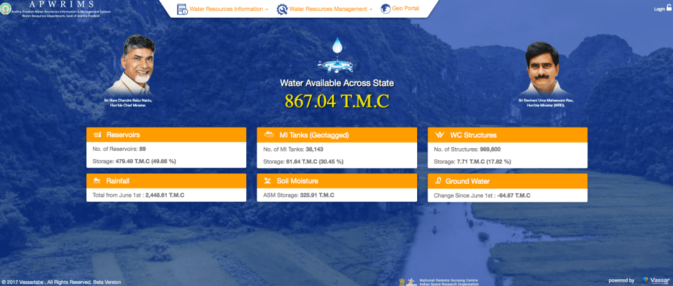
APWRIMS: Impressive Water Information System of Andhra Pradesh
Andhra Pradesh Water Resources Information and Management System[i] is truly impressive water information system, possibly not available in any other state or even at national level, at any time in India. The comprehensiveness of the water information system is striking, as it not only includes reservoir water storages of Major and Medium Projects, but also storages in minor projects, minor tanks, water conservation structures (check dams, percolation tanks) but also groundwater and most importantly, soil moisture. These are collected in real time from diverse information sources including on ground measurements, satellite based assessments and also sent via mobile apps from diverse sources. And the information is put out in real time, along with number of analysis. The data are collated and analysed using tools from Vassar Labs, like Machine learning, Artificial Intelligence and big data. Continue reading “APWRIMS: Impressive Water Information System of Andhra Pradesh”
Another Landslide Dam on Yarlung Tsangpo raises more questions
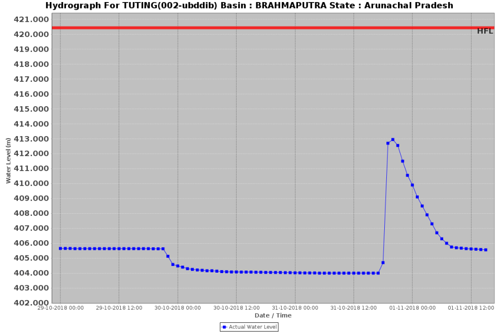
On Oct 29, 2018, another landslide dam blocked the path of Yarlung Tsangpo Dam, reportedly at the same location as the Oct 17,2018 landslide dam[i]. It breached on Oct 31, without any reported major calamity, but these repeated occurrences, twice in two weeks and third time in ten months (if we include Dec 2017[ii] landslides) raises a lot of questions. The silence of government of India institutions about the possible causes or other analysis, including by Central Water Commission, Union Ministry of Water Resources, National Disaster Management Authority or even National Remote Sensing Agency has, as expected, raised questions and speculations in Arunachal Pradesh. Continue reading “Another Landslide Dam on Yarlung Tsangpo raises more questions”
Why Sardar may have been uncomfortable with the 600 feet statue
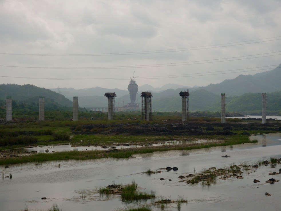
Consider the facts: The 600 feet tall statue of Sardar Patel that the Prime Minister of India will inaugurate on Patel’s Birthday on October 31, 2018 is situated bang in the middle of the Narmada river. To take up such unprecedented construction in the middle of the river would require, at the least, environment clearance, since the construction would have huge impacts on the river. No such clearance was sought or given. It would have required environmental impact assessment, environmental management plan, appraisal, public consultations, monitoring and compliance. NONE OF THIS HAPPENED. Continue reading “Why Sardar may have been uncomfortable with the 600 feet statue”
Landslide DAM on Tsangpo creates flood disaster risk for Siang
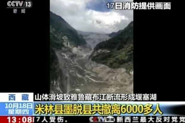
A massive dam, created by landslide in early hours (around 5 am) of Oct 17,2018 has blocked the main stream of Yarlung Tsangpo in Tibet. The reservoir behind the dam already has humungous 360 Million Cubic Meters (MCM) of water by 7 am on Oct 18, 2018 and as per latest reports (subsequently saw the CWC tweet put out at 955 pm on Oct 18, saying that storage had reached 484 MCM by 8 pm on Oct 18), the reservoir is still growing in size. The exact location of the landslide dam is uncertain. According to one source, the latitude longitude could be 94.93754° E, 29.74957° N, but this may not be accurate the likely location may be a few kilometers downstream from here. The Chinese media[i] has reported that the landslide dam is located at near Gyalha village in Milin or Manling county. According to some experts who visited the site, the dam could breach very soon, possibly on Oct 19, bringing massive floods along Siang river in Arunachal Pradesh. Continue reading “Landslide DAM on Tsangpo creates flood disaster risk for Siang”
Role of dams in Kerala’s 2018 floods
ABSTRACT: Many independent observers have argued that dams have played a role in increasing the proportions of Kerala flood disaster during July-Aug 2018. This article shows that Kerala dams violated many basic norms and if operated prudently, could have helped. It shows how post dam floods are different than pre dam floods. It lists the steps that would help in future disasters involving dams. The lessons are useful for all large dams of India.
In theory, every dam can help moderate floods in the downstream areas, as long as and as much as the dam has space to store water. In fact, every action that helps to store, hold, recharge (to groundwater aquifer), delay flow of rainwater from the catchment to the river would help moderate flow and hence flood in the river. Our catchments are fast losing that capacity, with continued destruction of natural forests, wetlands, local water bodies and also soil’s capacity to hold water. Continue reading “Role of dams in Kerala’s 2018 floods”
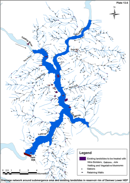
NBWL pushes Lower Demwe HEP on Lohit River in Arunachal Pradesh based on fudged WII report
The Minutes of 50th Meeting of Standing Committee (SC) of National Board of Wild Life (NBWL), held on 7th Sept 2018, were made available on 26th Sept 2018. On viewing the Minutes of Meeting, the petitioner to NGT Bimal Gogoi wrote to the Chairman and the Members of SC Of NBWL about the recommendation of the SC of NBWL on Demwe Lower Project.
Date : September 26, 2018
To: Dr. Harsh Vardhan
The Chairperson,
Standing Committee of the National Board for Wildlife,
New Delhi.
URGENT: Grant of wildlife clearance to Demwe Lower project based on faulty WII report is shocking and should be reversed
Dear Dr. Harsh Vardhan and Members of the Standing Committee of the NBWL,
Greetings from the Northeast! I have just perused the minutes of the 50th meeting of the SCNBWL and I am shocked to see that your committee has granted wildlife clearance to the 1750 MW Demwe Lower project based on a seriously flawed report of the Wildlife Institute of India (WII). Continue reading “NBWL pushes Lower Demwe HEP on Lohit River in Arunachal Pradesh based on fudged WII report”

Gujarat’s water crisis rooted in years of misplaced priorities
As things stand now, Gujarat is facing prospects of a serious water crisis that may extend till at least next average or above average monsoon. State level Rainfall so far this monsoon is 19% below average as on Sept 1. But the state level average hides the local situation.
Some of the districts that have received rainfall with high deficits, as per IMD figures till Sept 1, 2018 include: Kutch: -58%; Patan: -58%; Gandhinagar: -51%; Morbi: -47%; Ahmedabad: -48%; Surendranagar -43%; Banaskantha: -55%; Mehsana: -52%; Devbhoomi Dwarka: -40%. These district level figures indeed show massive rainfall deficit with less than a month of monsoon remaining. Continue reading “Gujarat’s water crisis rooted in years of misplaced priorities”
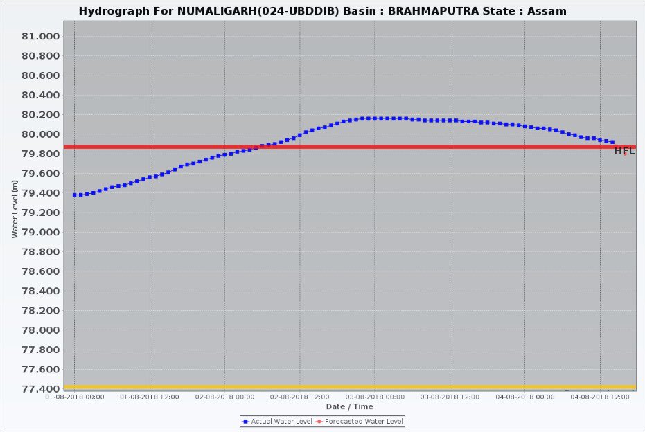
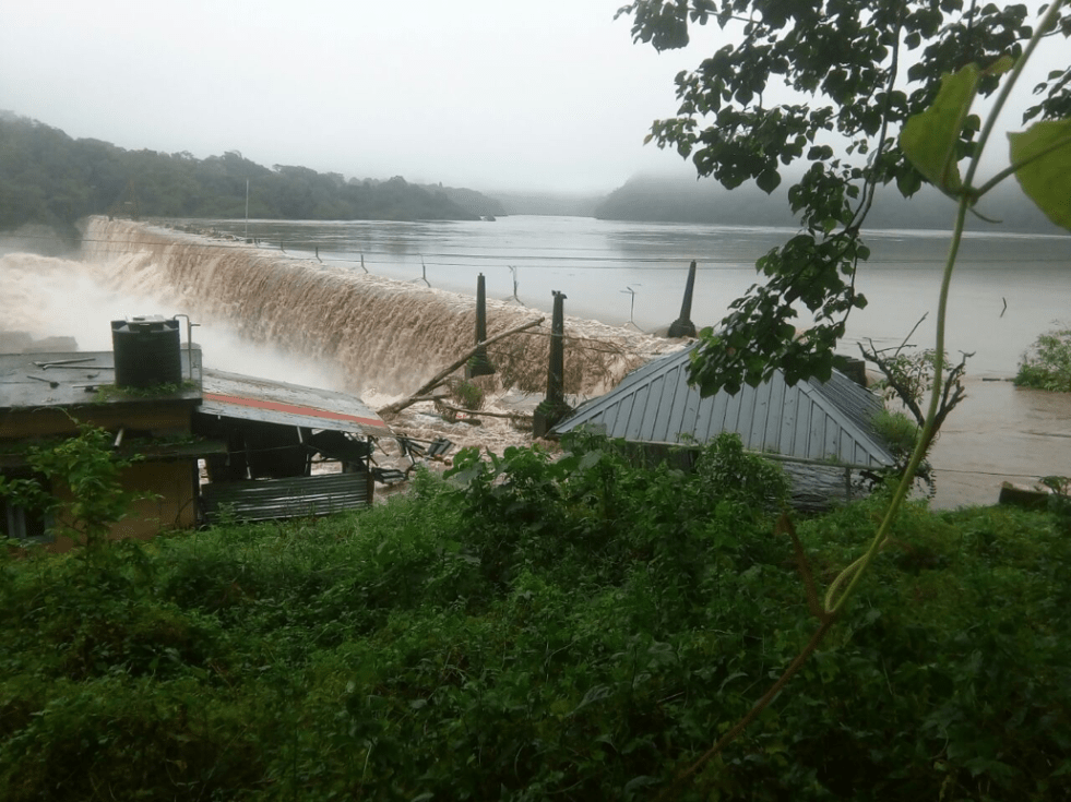
Role of Doyang Dam in bringing unprecedented floods in Golaghat
When Dhansiri river broke the highest flood level mark at Numaligarh site in early hours of Aug 2, 2018 in Golaghat district in Assam, it was not only completely out of the blue, the whole episode was unprecedented.
The earlier Highest Flood Level of Dhansiri River at Numaligarh was 79.87 m. The new HFL, it seems, was 80.18 m, full 31 cm above the previous HFL. This is rather rare, normally the new HFL would be a few cm higher, not almost one third of a meter. Secondly, the water level remained above 79.87 cm, the old HFL, for over 60 hours. This is also unusual, normally the water level rarely remains above HFL for more than a day or so. Thirdly, the earlier HFL was achieved on Sept 24, 1985, so this sudden episode of flood was breaking 33 year old record. Continue reading “Role of Doyang Dam in bringing unprecedented floods in Golaghat”
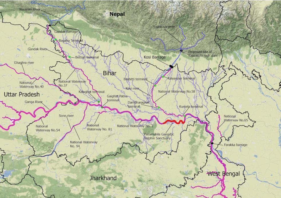
National Inland Waterways in Bihar: Viable or desirable?
A new surge in the developmental interventions in the rivers in India is seen with the implementation of National Inland Waterways Act, 2016. Under this Act, 138 stretches of the rivers, creeks, backwaters, estuaries, etc. in 24 states and 2 union territories will be developed as the ‘national inland waterways’ for the transportation of huge cargo and passenger vessels. Being declared as “national” means that the control and regulation of these waterways will be in the hands of the central government and not state governments. This project of Central Government is being pushed forward with the claims of inland water transport being cost-effect, environmental friendly and safe for the transportation of hazardous goods. However, these so called benefits are neither universal nor automatic as they will be dependent on certain conditions, and will accrue if and when those conditions are met. Development of these waterways will be controlled and regulated by Inland Waterways Authority of India (IWAI). Continue reading “National Inland Waterways in Bihar: Viable or desirable?”
