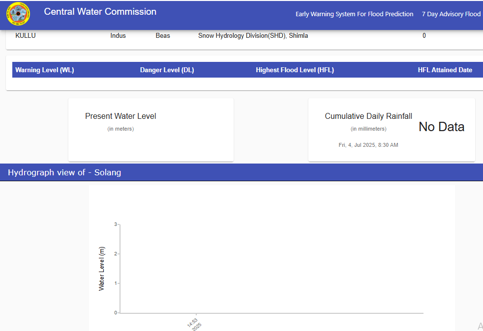
The current developments around Indus Waters Treaty are deeply troubling. Following the heinous attack on tourists in Pehelgam, India has announced that Indus Waters Treaty, the only water sharing mechanism between India and Pakistan put in place in 1960, has been put in abeyance.
Continue reading “Infrastructure Projects in Chenab Basin and Climate Change: Need to Exercise Caution”Category: Indus
The Moon River: People’s Story of Chenab
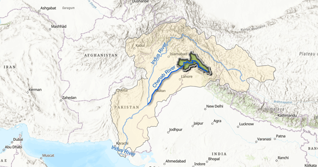
Chenab, which translates as the Moon River is the largest of the five tributaries of River Indus. It flows for about 974 kilometers from the High Himalayas of Lahaul to the forests of Jammu and Kashmir and onto the plains of Pakistan. Its main tributaries in India include Miyar, Marusudhar and Tawi. In the vast plains of Punjab in Pakistan, it is met by Jhelum, Ravi and Sutlej to form the mighty Panjnad before it meets the Indus. Its catchment, spread across 67,430 km2, is shared between the two countries.

Chenab is Chandrabhaga (Crescent Moon) in its headwaters. It was the River Asikni in Rigveda, and the Acesines for the ancient Greek. From sparse mountain settlements of Lahaul to the bustling urban centers of Sialkot, more than 10 million people live and prosper along the Chenab. Hydropower projects operational and under constructions on the river have an installed capacity of more than 5000 MW (Central Electricity Authority 2024), and its canals irrigate hundreds of thousands of acres in Pakistan and India (Shakir et al).
Continue reading “The Moon River: People’s Story of Chenab”Are we ready to use more water from snow melt in Indus basin this year?
Union Water Resources Minister Shri Gajendra Singh Shekhawat has recently said that the snow this year on Himalayan peaks is the highest in 50 years, and reservoirs like Bhakra, Pong, Ranjit Sagar, Ramganga, Tehri, etc will receive very high water inflow from snowmelt during summer and SW Monsoon.[i] This is in fact the third warning this year on this issue. Earlier on Feb 27, 2020 and then again on May 4, 2020, the Bhakra Beas Management Board (BBMB) provided the same warning to its partner states. However, neither the Union Minister & BBMB, nor the partner states seem ready or doing anything to prepare for the unprecedented situation that the dams and rivers may bring in ongoing summer and coming SW monsoon.
In fact the situation is similar to the one that happened twice at Bhakra-Pong-Ranjit Sagar Dams last year[ii]. Even then not only there were massive floods, but the water flowed away to Pakistan, totally against the declared pronouncements and policy of Indian Government leaders including the Prime Minister. Continue reading “Are we ready to use more water from snow melt in Indus basin this year?”
Rivers are Us
Above: Sindhu by Anoop Patnaik, Outlook Traveller
“To choose safe waters
is the route of imposters:
Those who love
take on the mighty river.” (Seeking the Beloved, translations of Shah Abdul Latif Bhitai’s Poems)

In the inky, starless night, beautiful Sohni plunged into the flooded River Chenab to meet her beloved Mehwal, knowing well that she will never make it to the other side. Sohni is one of the seven heroines brought to life by Shah Abdul Latif Bhitai, a remarkable 18th Century Sufi poet, mystic and reformist living on the banks of Indus. Sohni was the wife of a potter, in love with Mahiwal, a cattle herder from the banks of the Chenab. Like all poignant love stories, Sohni-Mahiwal’s tale was short-lived, but 300 years later, the legend of Sohni flows through the Chenab and lives on in the songs of peasants. In Punjab, the land of five rivers, they sing of Sohni, of the roaring, helpless river and of mad, wilful love. The narrative is so unwrinkled and dewy that till this day, silent figures sweep the modest tombs of Sohni and Mahiwal, hoping that their love will meet a better fate. Like Sur Sohni (Sohni’s poem) from Shah jo Risalo (Poetry of the Shah) prophecised:
“Hundreds were by the river drowned,
But the river was drowned by this maiden.” Continue reading “Rivers are Us”
India Pakistan resume talks on Indus Treaty: Stakes are high
When on March 20-21, 2017, on the eve of World Water Day, India and Pakistan’s Permanent Indus Commission met in Islamabad for its 113rd meeting, there was a lot at stake besides the immediate issue or even the Indus Treaty.
In many ways, the Indus Treaty remains a bright spot in relations between these two neighbors and the treaty keeps bringing them back to the talking table…This is the magic of a shared river! Continue reading “India Pakistan resume talks on Indus Treaty: Stakes are high”
Sindh People March to Protect Indus River
GUEST BLOG by Muhammad Ali Shah, Dr. Aly Ercelan & Roshan Bhatti
Sindh Peoples Caravan March 1-14, 2017 Protect Our Rivers and Delta
Across the world the greed of capitalism has created water crises. Asia in general and South Asia in particular is no exception. This region is marred with complex and multidimensional aspects of water crises. Not only the brute availability of water has declined, but also the health of water bodies has been badly affected. A deep probe into the issue reveals that water crisis has been created by weak and deliberate mal-governance. Both wrong incentives and lack of penalties have led to major ecological disasters. These include deforestation, destruction of wetlands, dumping of industrial waste into waterways, construction of dams, overexploitation of the major river systems, corporate control on water resources and unplanned urbanization due to increasing population pressure.

All these issues pose serious threats to life and health of people and water systems of South Asian River Systems, including Indus river system. Our analysis reveals that anti-human and anti-environment policies have been applied and imposed in South Asia with the same rapacity as colonial powers did to impose control over citizens. Post-independence, growth policies have become excuses for privatization and in favor of corporate monopolies rather than protection of the commons for public welfare. Among regions around the world, South Asia is the second number in the construction of large dams. Pursuing neo-colonial control over natural resources, the ecological consequences have become hazardous to life and livelihood.
Continue reading “Sindh People March to Protect Indus River”
Haryana Rivers Profile: (Part-I – Indus Basin)
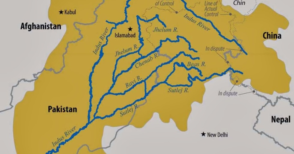
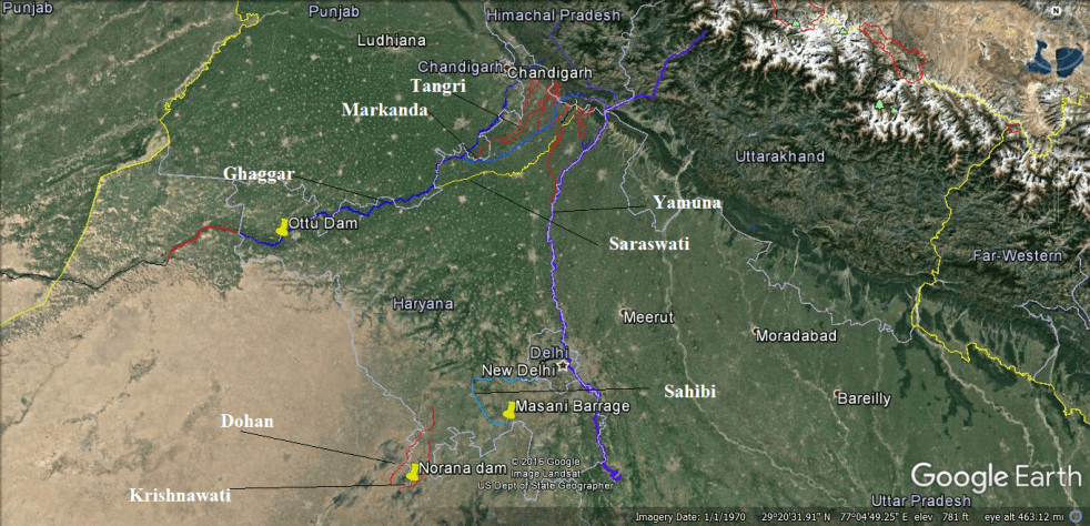
India is a land of several great rivers[1]. Haryana[2] the 20th Indian state has also been enriched by numbers of rivers, streams and rivulets. These rivers only strike public discourses during monsoon when they flood human habitations although pollution and sand mining incidents are routinely covered. Moreover there is no Government Department in the State which is in control or possession of complete information on the rivers of the State, as the various State Government Agencies in limited manner deal with specific issues affecting the rivers and there are Government Agencies also whose plans or projects impact the rivers in adverse manner. This two part blog report from SANDRP strives to present a picture on the rivers of Haryana. The State is broadly divided by two basins: Indus and Ganga. This first part of the blog mainly focuses on rives which are part of Indus basin. The second part will bring information of other rivers in the State which join the Ganga basin. Apart from putting together the basic facts, the blog series also highlights the key issues and present day status of these river systems.
Continue reading “Haryana Rivers Profile: (Part-I – Indus Basin)”
So who will suffer in the Indus water imbroglio?
Diplomatic and military strategies, by definition, are not decided through public debates. So the jingoism around Indus treaty with Pakistan seems more like an attempt at sending threatening signals. But it will have multiple serious ramifications in any case, so it is worth deliberating about.
The 1960 Indus treaty has allocated rights of development on three eastern tributaries (Sutlej, Beas & Ravi) to India, and we have exhausted that entitlement almost fully. Attempts to use the occasional remaining flow will mean a huge impact in Indian Punjab, which is unlikely to resonate well with the people of Punjab. The treaty gave Pakistan dominant right of development of the three western tributaries (Chenab, Jhelum and Indus), India has limitations about water use (both in terms of quantity and manner of use) in case of the western rivers. India has not yet exhausted the entitlement in this case.
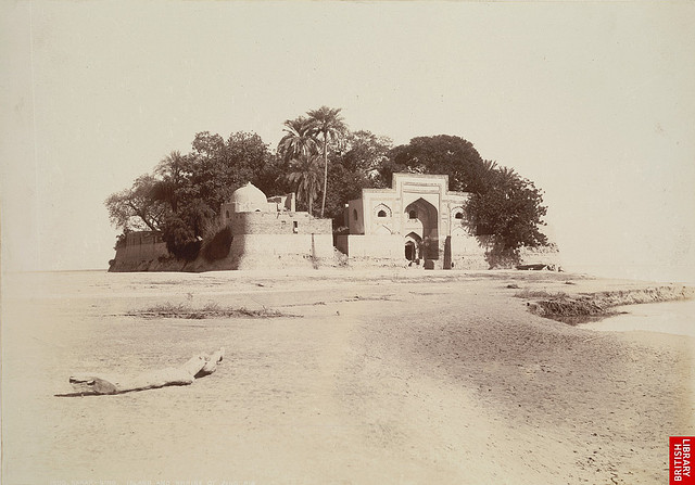
Continue reading “So who will suffer in the Indus water imbroglio?”Jhulelal or Zindapir: River Saints, fish and flows of the Indus
Above: Zindapir Shrine at Sukkur Photo from: British Library
Perhaps we all have our pet projects which we wish would go on forever. I have been working on a Primer on Riverine Fisheries of South Asia for some years now (my office may disagree with the definition of ‘some’). Like a magpie collecting shiny knick-knacks, I keep collecting (quite serendipitously, or so I think) anecdotes and interviews and snippets on the subject. Continue reading “Jhulelal or Zindapir: River Saints, fish and flows of the Indus”
IWMI report on Glaciers and Snow cover in Himalayas in Changing Climate: Significant Impact on Seasonal flow of the Rivers in India
International Water Management Institute (IWMI) has recently published a study named Glacier Systems and Seasonal Snow Cover in Six Major Asian River Basins: Hydrological Role under Changing Climate, authored by Oxana S. Savoskul and Vladimir Smakhtin which claims that the hydrological role of the melt-water resources in six major rivers e.g. Indus, Ganges, Brahmaputra, Syr Darya, Amu Darya and Mekong of the Hindukush-Himalayan region (HKH) has been comprehensively assessed for the first time on a basin scale. Reviewing already published studies, this report draws some interesting conclusions regarding the role of glacier and snow meting for six river basins which includes three major rivers basins of India.
The map below shows area of the river basins included in this study. In this report, the term ‘melt-water resources’ has been used to cover glacier systems and seasonal snow cover. This report uses 1961-1990 status of melt-water resources as the baseline and compares with the 2001-2010 using the following characteristics: specific glacier runoff (average depth of annual discharge from glacier-covered area), basin total glacier runoff, shares of renewable and nonrenewable components in glacier runoff, total seasonal surface snowmelt from non-glaciated areas, portion of seasonal snowmelt lost for the recharge of groundwater aquifers, the contribution of glacier runoff and seasonal snowmelt to mean annual flow (MAF).

The authors have used Glacier mass budget-based methods and hydrograph separation techniques which they stated as suitable for basin-scale assessments instead of the temperature-index methods. They say that application of these two methods in semi-distributed models can give the highest currently possible accuracy of +30%. The authors opine that many of the studies done previously had confused between the ‘snowmelt’ and ‘glacier-melt’ because these studies have not dealt with terminologies and methodologies in detail. The report states that there is a scarcity of glacier runoff estimates in peer-reviewed papers, “An analysis of publications on modeling runoff from large- and medium-scale glaciated catchments….. indicates that not many of these dealt with modeling glacier runoff per se. Even fewer report their evaluations of glacier runoff separately from snowmelt, if at all.”
For the three of the six river basins studies and which flow through India, i.e. Indus, Ganges and Brahmaputra the total annual glacier runoff for the period of 1961-1990 was 41 km3,16 km3 and 17 km3 respectively. But in the recent periods of 2001-2010, total glacier runoff was reduced to 36 km3, 15 km3 and 16 km3 respectively for the three basins, see Table 1 for details.
It is clear from the table that while Indus and Brahmaputra basins have similar percentage of area under glaciers and snowmelt, the reduction in the glacier and snow cover area are more pronounced in Indus basin. Besides, in all the three basins the reduction in glacier area is more pronounced that the snow cover area. However, the contribution of glacier melt and also snow melt to run-off is much higher in Indus basin compared to Brahmaputra basin, showing the greater role of precipitation in Brahmaputra basin. Within the Indus basin even though seasonal snow covers 28% of the total area, much than the 2.6% occupied by glaciers during 1961-90, the contribution of two sources to Mean Annual Flow is almost same. But a question arises, has the contribution of glacier melt to the runoff increased in any of the basins in the recent decade? The answer is surprisingly, no.
Table 1: Recent changes in the glaciers and seasonal snow and their contributions to MAF
| Basin | Part of basin area(%) covered by | Contribution to MAF (%) | ||
| Glaciers | Seasonal Snow | Glacier runoff | Seasonal Snowmelt | |
|
1961-1990 |
||||
|
INDUS |
2.6 |
28 | 18 |
19 |
| GANGES |
1.2 |
6 | 4 |
2 |
|
BRAHMAPUTRA |
2.7 | 27 | 2 |
2 |
|
2001 -2010 |
||||
|
INDUS |
1.8 | 25 | 15 | 16 |
| GANGES |
0.9 |
6 | 3 |
1 |
|
BRAHMAPUTRA |
2.2 | 26 | 2 |
2 |
For the Ganges basin, the report says that heavy summer precipitation almost solely determines MAF volume for the basin. Maximum seasonal snow area in the Ganges basin makes just 6% of the entire basin area. Similar situation were reported for the Brahmaputra basin, where the lower parts of the basin i.e. Southeastern Tibet and Eastern Himalayas where nearly 75% of the basin’s glaciers are located, witness heavy summer monsoon rains. Regarding Indus basin the report says, “Precipitation in the IndusBasin is more evenly distributed between the seasons, but is highly variable spatially – similar to Brahmaputra and Amu Darya, where annual precipitation in some catchments is tenfold (3,000 mm) of that in the other glacier-covered parts of the basin (300 mm).”
Reviewing already published documents the report states “it appears that the research in High Asia is concerned much more with CC impacts than with objects of the impact. Yet, understanding of the expected basin-scale changes in glacier runoff in response to climate change remains largely unclear.”
The report does an analysis of assessments done on impact of climate change on water availability in Himalayas and concludes that many assessments rely on poorly verified sources. The report refers to the statement made by Cruz et al. (2007) “The current trends of glacier-melts suggest that the Ganga, Indus, Brahmaputra and other rivers that criss-cross the northern Indian plain could likely become seasonal rivers in the near future as a consequence of climate change…,” This statement was admitted as a typing error after publication but even then this has been reiterated as an apocalyptic vision in NGO reports.
Using the Table 2 given below, the report states that glacier contribution is a minor item in the annual river water budgets in the Ganges and Brahmaputra basins. The report says “The impact of climate change was found to be more prominent on seasonal rather than annual water availability.” It is clear from the table that, in the recent decades non-renewable component in all three basins have gone up while renewable and total volume of water from glacier melt have come down. It is also noteworthy that, even though Brahmaputra basin has more area under glacier cover than the Ganges basin (see Table 1), the volume of water from non renewable glacier flow was more in both periods in the Ganges basin. Besides, the percentage of increase in nonrenewable glacier runoff components during 2001-10 is highest among all three basins, signifying that glaciers are melting fastest in Ganga basin.
Table 2: Contribution of renewable and non-renewable components to glacial runoff
| Basin | Glacier runoff components | Total Glacier runoff (km3) | Total Glacier runoff contribution to MAF (%) | |
| Renewable (km3) | Nonrenewable (km3) | |||
|
1961-1990 |
||||
| INDUS |
33.0 |
8.14 | 41.2 |
18 |
| GANGES |
11.0 |
4.74 | 15.7 |
4 |
| BRAHMAPUTRA |
12.7 |
4.29 | 17.0 |
2 |
|
2001 -2010 |
||||
| INDUS |
24.5 |
11.62 | 36.1 |
15 |
| GANGES |
8.1 |
6.95 | 15.0 |
3 |
| BRAHMAPUTRA |
10.6 |
5.05 | 15.7 |
2 |
The reports also states, “Glaciers and seasonal snow in CC-impact assessments should be perceived as natural water reservoirs with gradually diminishing storage and flow regulation capacity, both on intra-annual and inter-annual scale. Potential changes of precipitation regime coupled with effects of temperature rise on evapo-transpiration will impact future hydrological regimes of the major rivers much more significantly, affecting both MAF and flow seasonality.”
The authors of this report clear some fog around climate change and Himalayan glacier system and snow-melt. One lacuna of the report is that even though the report discusses glacier run-off it makes no mentions of glacier lakes and glacier lakes induced floods. There are several incidents of glacier lake induced floods happening in the basins discussed. There is evidence to show that in the recent flood devastation in Uttarakhand in India glacial lakes played significant role.
Parag Jyoti Saikia
with inputs from Himanshu Thakkar
South Asia Network on Dams, Rivers and People (www.sandrp.in)