In a classical Thumri rendition, Ustad Rashid Khan sings about how a river, which was once a friend, has turned into a foe…Nadiya Bairi Bhayi.. Something similar is happening at a number of places in India, where the river, a life giving friend, is turning into a deadly force.
~~
Drowning of 25 students following sudden water releases from the 126 MW Larji Dam in Mandi, Himachal Pradesh is one more saddening and shocking incidence in the long list of hydropower-release related disasters in India where rivers are turned into death traps.
On the 18th April 2014, 11 year old Radhika Gurung studying in standard fourth was accompanying her sisters Chandra and Maya along the river Teesta near Bardang, Sikkim. Suddenly, without having any time to respond, all three school girls were washed away by a forceful water released by upstream 510 MW Teesta V Hydropower project in Sikkim. While Maya and Chandra were lucky to be saved, Radhika was not so lucky. She lost her life. Residents here say that NHPC, the dam operator, does not sound any sirens or alarms while releasing water in the downstream for producing hydroelectricity and villagers live in constant fear of the river.[1] Residents demanded strict action against NHPC, but no action has been taken.
On the 28th March 2013, 5 people, including two small children aged 2 and 3 drowned in the Bhawani River near Mettupalayna when 100 MW Kundah IV HEP (Tamil Nadu) on the Pillur Dam suddenly released discharge of about 6000 cusecs water. The family was sitting on the rocks in the riverbed when water levels started rising, and they did not get enough time even to scramble out of the river with the two children, says the sole survivor. Tangedco officials stated that although alarm is sounded at the nearest hamlets, it does not reach the downstream regions.[2] Local villagers say no alarm is sounded. No action has been taken against Tangedco.[3]
On 8th January 2012, a family of seven people, including a child, drowned in the Cauvery River when water was released from the 30 MW Bhavani Kattalai Barrage-II (BKBII in Tamil Nadu). The same day, two youths were also swept off and drowned in the same river due to this release.[4] There are no reports of any responsibility fixed or any action taken against the Barrage authorities or Tangedco, although it was found that there was not even a siren installed to alert people in the downstream about water releases.[5]
Uttarakhand has a history of deaths due to sudden releases from its several hydropower dams. In April 2011, three pilgrims were washed away due to sudden release of water from Maneri Bhali-1 Dam on the Bhagirathi in Uttarakhand.[6] In 2006 too, three women were washed away by such releases by Maneri Bhali.[7] The district magistrate of Uttarkashi district ordered filing a case against the Executive Engineer of the dam after a number of organisations demanded action against the guilty. Again in November 2007, Uttarakhand Jal VIdyut Nigam Limited was testing the opening and closing of gates of Maneri Bhali Stage II, when two youths were washed away by these releases. [8] Following a protest by locals and Matu Jan Sangathan, the Executive Engineer and District Magistrate simply issued a notice which said that “Maneri Bhali Hydropower Projects exists in the upstream of Joshiyada Barrage and water can be released at any time, without prior notice from here”.
Similar notice is also given by NEEPCO, which operates the Ranganadi Dam and 405 MW Dikrong Power House in Arunachal Pradesh, on the Assam border. “The gates of Ranganadi diversion dam may be opened at any time. NEEPCO will not take any responsibility for any loss of life of humans, animals or damage to property”.
Similar notice sits on the banks of the Chalakudy River near the Athirappilly falls in Kerala and the Kadar tribes, which traditionally stay close to the river and are skilled fisher folk too, are fearful of entering the river.
Chamera HEP in Himachal Pradesh has been held responsible for sudden water releases and resultant deaths in the downstream. As per retired IAS Officer Avay Shukla who resides in Himachal, similar incidences which resulted in loss of lives have also happened due to Nathpa Jhakri and other dams in the state.
In December 2011,three youth were drowned in the Netravathi River when water was released by the fraudulently combined 48.50 MW AMR project (Karnataka) now owned by Greenko[9]. Villagers protested at the site, but this has not been the first instance of drowning because of this project. Villagers accuse the dam for the deaths of as many as 7 unsuspecting people in the downstream. This dam is now increasing its height and one more project is being added to it.
Protest against sudden water release by fraudulently combined 48.50 MW project in Bantwal, Dakshin Kannada by Greenko Photo: Daiji World
On October 1, 2006, at least 39 people were killed in Datia district in Madhya Pradesh when suddenly large amount of water was released from the upstream Manikheda dam on Sind River in Shivpuri district. There was no warning prior to these sudden releases and hence unsuspecting people crossing the river were washed away[10]. Chief Minister Shivraj Chauvan ordered a judicial probe into this incidence in 2006, however, and a report was submitted by retired High Court Judge in 2007. Since then, the report has been buried and several attempts of RTI activists to access the report have been in vain. The government has not released the report, forget acting upon it or fixing responsibility after 8 years[11].
In April 2005, at least 70 people were killed at Dharaji in Dewas district of Madhya Pradesh due to sudden release of huge quantity of water from the upstream Indira Sagar Dam on Narmada river. Principal Secretary Water Resources Madhya Pradesh inquired into the incident and found that “there was no coordination between agencies”[12]. No accountability was fixed and no one was held responsible. NHPC, who operated 1000 MW Indira Sagar Project, simply claimed that it was a case of miscommunication and that it was not aware of the religious mela in the downstream of the river. As SANDRP observed then, “ It just shows how far removed is the dam operator from the welfare of the people in Narmada as the fair annually gathers more than 100,000 people of the banks of the river. It is a scandal that no one was held responsible for the manmade flood which resulted in the mishap[13].”
Above incidents make it clear that incident at Larji is not the first and will not be the last, if we continue non transparency and non accountability in hydropower dam operations.
Some Questions that arise from these events:
Do sanctioning authorities and dam operators reaslise that each of these projects convert an entire river ( not limited to the hydropower project) in the downstream area into a potential death trap? Do they assess the impacts of the various possible operations of the projects in the downstream area and envisage, plan and implement measures to avoid death and destruction in the downstream areas?
Can cordoning off and alienating a river, indicating that it is dangerous, be a solution to this? Are measures like alarms, sirens, lights enough when a river experiences order of magnitude sudden change in its flow due to dam and hydropower releases?
Is it ok to have hundreds of dam-related deaths in the recent years due to irresponsible and non-transparent dam operations and not have any responsibility fixed?
The obvious answer to the above seems NO.
Some Recommendations: As we have seen above, many man made disasters have happened in India over the last decade and governments and dam operators have learnt no lessons. The avoidable tragedies are repeating without any change. India is possibly the only country in the world where such events have been happening in such large numbers. Here we are recommending some basic steps if we want to avoid or minimise occurrence of such tragedies in future.
MEASURES FOR TRANSPARENT, INCLUSIVE MANAGEMENT NORMS IN OPERATION OF ALL EXISTING DAMS AND HYDROPOWER PROJECTS:
For every operating Dam and Hydropower project in India there should be clearly defined operating procedure in public domain. This operating procedure will include the steps taken before release of water from dam or power house, how the releases will be increases (the increase should be in steps and not suddenly releasing huge quantity) or decreased, how these will be planned in advance, who all will need to be informed about such plans in what manner and what safety measures will be taken. This will also include who all will be responsible for designing, monitoring and implementing these measures. There should be boards at regular intervals in the downstream area in language and manner that local people and outsiders can understand and the boards should also indicate the danger zone and what kind of sirens and hooters may blow before the releases.
The operating procedure will take into account where there are upstream projects and how the upstream projects are going to influence the inflow into the project and how information will be shared with upstream and downstream projects and in public domain. The Power Load Dispatch Centres should also remember that when any hydropower project is asked to shut on or off, there are consequences in the river and they should be asked to keep such consequences in mind and time required to alert the regions in risk.
For every dam there should be a legally empowered official management committee for the project management, in which 50% people should be from govt and 50% should be non govt persons, including local community representatives and this committee should be in charge of providing oversight over management, including operation of the project and should have right to get all the information about the project.
Hourly water levels and release data of hydropower dams be made available in public domain on daily bases. Water levels corresponding to discharges (and possible timings where applicable) should be physically marked on the river banks, local communities should be involved in this, evacuation methods and mock drills should be organised by dam proponent from time to time in all places along the river where the impacts reach.
THE EXISTING DAMS AND HYDROPOWER PROJECTS SHOULD BE MANDATED TO PUT ALL THIS IN PLACE WITHIN A PERIOD OF NEXT THREE MONTHS THROUGH A LEGALLY EMPOWERED STEP IN ALL STATES.
SANCTIONING PROCESS FOR NEW PROJECTS, INCLUDING FOR UNDER CONSTRUCTION PROJECTS:
Safety measures related to, including water releases for all kind of eventualities and their downstream impacts and management plan should be an integral part of EIA and EMP. The aspect should be thoroughly discussed while appraising the project, and clear cut roles and responsibilities fixed. Mitigation measures should include proper siting of the project, gradual upramping & Downramping of releases in a clearly defined way and where planning is mandatory, safe operation of discharges through dams, etc.
Entire clearance mechanism for cascade hydropower projects in the Himalayas and elsewhere needs to be revisited to include the operational safety measures considering the cumulative operation of the projects. Projects where operational safety measures alone will not be sufficient due to massive fluctuations/location/upstream projects, etc., should be urgently dropped.
Peaking power projects should be restricted to certain locations like deep mountain gorges, after proper studies. Such projects should not be permitted as rivers enter into floodplains, due to their significant impact on the downstream and also in biodiversity rich river stretches.
SAFETY MEASURES BEFORE AND DURING WATER RELEASES:
Primary safety measures like informing the administration well in advance before release, sirens, hoots, alarms, lights, buoys should be strictly enforced and a clear responsibility of these measures should be adopted, for the entire zone in risk, sign boards at every 50 mts interval in such zones in languages and manner that local people and outsiders can understand, and which also show the specific risk zone. Where sudden unseasonal releases are likely, include police surveillance of the risk zone during danger period.
WHEN THERE IS DEATH AND DESTRUCTION IN THE DOWNSTREAM AREA:
Exemplary punishments should be fixed not only for dam operators,but also engineers and dam companies in case of negligence. Independent inquiry will be required since departmental or inquiries by District administration or government officials are not likely to be credible.
Since the designed safety measures in case of Larji were clearly inadequate, not just the operational staff but all those responsible for such shoddy safety plan should be held accountable.
It is unacceptable that a life giving and beautiful entity like a river should be converted into a dangerous and deadly force for our energy needs, without even the most basic precautions in place.
7 Students Get Justice 16 Yrs after Meeting Watery Grave
By Express News Service Published: 18th September 2014 06:03 AM
BHUBANESWAR: In a significant judgment, a civil court on Wednesday awarded a compensation of `25 lakh each to the families of seven students of University College of Engineering (UCE) of Burla __ now VSS University of Technology __ who were swept away by unannounced and untimely release of water from Hirakud dam 16 years ago.
Civil Judge (Senior Division), Bhubaneswar, Sangram Keshari Patnaik, who pronounced the verdict in his 31-page judgement, ordered that the compensation be paid with 6 per cent interest effective from 2001, the year when the case was filed before the court.
The tragic incident had occurred on January 30, 1998 when eight students of the UCE of Burla were taking pictures on a sand bar of Mahanadi as part of the Spring Festival activity. The water flow of the river rose menacingly and barring Soubhagya Barik, the rest seven second-year engineering students were swept away and met their watery grave.
The Hirakud Dam authorities had allegedly opened nine gates during the non-monsoon season which led to the tragic incident as no caution was sounded before the release of the water.
The State Government ordered a Revenue Divisional Commissioner-level inquiry into the incident and the then RDC Hrushikesh Panda submitted the report to the Government on March 29, 1998. The Government accepted it on May 19.
The RDC, in his report, had examined 77 witnesses and 31 affidavits were filed. Panda, in his report, had highlighted the irresponsibility of the engineers and stated that even the Sambalpur Collector and the Superintendent of Police were not intimated about the release of water, let alone the public.
Basing on the report, the State Government had announced a compensation of `3 lakh each to the family of seven students. However, considering the compensation inadequate, a petition was filed before the Orissa High Court. In 2001, the HC directed that the case must be filed before a civil court since it pertained to compensation.
According to Madhumadhab Jena and Sidharth Das, counsels for the deceased’s families, the Civil Judge Court took into account various aspects, including the academic background of the students of UCE.
This post is the second of a two part summary of the results of a study on the socio-ecological impacts of privatized, small, run-of-the-river hydropower projects in Himachal Pradesh.[1] The study is based on field research conducted in 2012 on all 49 completed small hydropower projects in the state.[1] Part one, posted here on 8 June, reviews the implementation of the Himachal Pradesh power policy governing privatized small hydropower development and examines the local social and environmental effects of commissioned small (defined as 5 MW or less) hydropower projects. This part will address two of the claimed local benefits of small hydropower development, namely monetary contributions by the project developer to local community development projects through the Local Area Development Authority (LADA) and local employment generation. After a brief discussion of the relationship between small hydropower projects and carbon credits through the Clean Development Mechanism, the article reviews two promising institutional models for small hydropower development and concludes with a set of recommendations.
Local Area Development Authority– Implementation and Accountability Challenges
The 2006 Hydropower Policy includes provisions for tangible local benefits, in part to foster local support for power projects. One primary mechanism is the requirement that project developers deposit one percent of the project cost into an account with the district commissioner. These funds, known as Local Area Development Funds, are to be allocated by the Local Area Development Authority (LADA) to support local development activities, particularly related to infrastructure and services.[2]
In our survey of the 49 commissioned small hydropower projects we found that the LADA program was not working as well as intended. Inconsistent record keeping by district authorities, the lack of clearly defined project affected areas, and uneven levels of awareness among local pradhans about the program have enabled some project developers in Himachal to avoid fulfilling their obligations to local communities. The district revenue department office in Kangra was the only district office that maintained a comprehensive record of LADA obligations and tracked how much the project developer had paid and how much was still owed. Without such a record, officials in the remaining six districts found it extremely difficult to hold the project developer accountable for their LADA payment obligations. For example, in District Chamba, ten small hydropower projects together owe Rs 247 lakhs. However, as of the summer of 2012 they had paid only Rs 70 lakhs and the developers of three projects had contributed nothing at all. District administrators seem to have little authority or recourse, beyond personal persuasion, to compel the project developer to make the required contributions.
There are also challenges with defining the Project Affected Area (PAA) and Project Affected Zone (PAZ), which is important because 70% of the LADA funds are earmarked for projects in the PAA and 30% for projects in the PAZ. Very few small hydropower projects have defined PAAs and none had defined a PAZ. The lack of clearly defined affected areas raises questions about whether or not the authorized development projects actually reach those households and hamlets most affected by the hydropower project.
A related concern is the unevenness of awareness about the LADA program among village pradhans. Several village pradhans, especially in the remote areas of the state, had never heard of the LADA program, even though one or more small hydropower projects were located within their panchayat boundaries. Where the program was functional, there are sometimes disputes between the LADA committee and the district commissioner concerning which projects to fund and whether to prioritize projects oriented towards strengthening local employment generation or hard infrastructure development.
We did encounter one example of a panchayat in which the LADA program was working as intended. The pradhan of the panchayat, located in District Kangra, was a retired military officer. Well aware of the LADA obligations of the small hydropower project developers in his panchayat, he maintained close communication with the district commissioner’s office in order to ensure that the required deposits were made. The pradhan also pressured the LADA committee to identify potential projects in a timely fashion and he followed up with the district commissioner to ensure that the expenditure of the requisite funds was authorized. As a result, in this panchayat LADA funds had been used to construct a cricket playing field, veterinary dispensary, and a handsome hall for village meetings and social functions (figures 1 and 2). Furthermore, in part due to the effective implementation of the LADA program and the fact that the small hydropower project did not annex cultivated areas, local opposition to the projects was virtually nonexistent. This example suggests that the LADA can offer tangible local benefits if accurate records are kept, if the project developers are compelled to contribute the requisite amounts, if village pradhans know about the program and their entitlements under it, and if the district administration supports program implementation.
Employment Generation –Unrealized Potential for Secure Jobs
In addition to requiring project developers to contribute to the Local Area Development Authority, the 2006 Hydropower Policy seeks to generate local benefits by stipulating that 70% of the project’s workers be from Himachal Pradesh. Because the lack of local employment opportunities is one of the primary drivers of migration from hill areas, the provision of permanent jobs through small hydropower projects could be a significant benefit. In addition to a steady income, permanent regular employees participate in government-approved pension plans, receive compensation for work-related accidents and injuries, and are protected from arbitrary dismissal. The project developer is also required to register all workers with the Labour Department and the local police station on a monthly basis.
While the 49 commissioned small hydropower projects in the state generate significant employment, more than half of project developers evade complying with labor law. All told, the 49 projects employ a total of 951 people, 603 of whom come from the panchayat(s) in which the project is located. On average, a 5 MW project employs approximately 20 people. While the total employment these projects generate is substantial, only 22 project developers have registered their employees with the state Labour Department as regular employees. These workers do receive the protections and benefits of the state’s labor laws, and some of them (in three projects) are also provided subsidized lodging and meals. However, the workers in the remaining 27 small hydropower projects, while doing the same work as regular employees in other projects, are hired on a daily wage basis and are thus excluded from the benefits and security of regular employment. A further disjuncture arises from the fact that only 11 project developers have established provident fund contributions for their employees, the remaining 38 have not. For the majority of workers in small hydropower projects, one of the most important potential local benefits – secure employment – has not been realized.
Given the significant risk of injury or death in this sector, it is of particular concern that unregistered workers are less likely than registered workers to receive compensation should an accident occur. While we did not develop comprehensive information about accidents and injuries, we did confirm worker deaths, the great majority of which occurred during the project construction phase due to tunnel collapses, falling rock, landslides, and tractor accidents. A total of 40 people died in accidents related to the construction of the commissioned small hydropower projects in the state, 18 were Himachali and 22 were from neighboring states or from Nepal. Only three of the families of the forty workers who died in fatal accidents received some form of compensation. The lack of proper registration and the general absence of compensation suggests the extent to which project developers and their contractors treat workers as a disposable labor force.
The common practice of contracting out project construction work to subcontractors who hire large numbers of employees challenges the ability of unions to advocate for project workers.[3] Questions arise concerning who is ultimately responsible for following the relevant labor laws and protections – the project developer or the developer’s subcontractors (figure 3)? Project developers can evade accountability through the use of subcontractors or by creating subsidiary companies. For example, in District Kangra in May, 2010 the local construction worker union notified a small hydropower project developer of its intent to strike due to violations of labor laws and working conditions. In a letter the developer responded that the strike was “totally illegal and off the mark” as the developer was not the owner of the plant but was “merely the contractor.” Furthermore the developer noted that the project was “generating power in the interest of the public of Himachal Pradesh,” and was “a property of the State and a national asset,” and thus the calling of the strike was “illegal from all perspectives.” While it is true that the developer to whom the labor union had sent the notice of intent to strike is not the company listed as the owner of the project in the state of Himachal Pradesh’s records, it is also true that the listed company is actually a subsidiary of the developer, whose address is the same as the developer and whose website leads directly to that of the developer. Furthermore, the power project is showcased on the developer’s website as one of four small hydropower projects they have constructed and are currently operating in District Kangra. The developer’s attempt to evade accountability for labor law violations by creating a fictitious subsidiary demonstrates the challenges unions face when they seek redress for labor law violations and demand worker rights
Payments to Developers for Renewable Energy Production
Part One of this article discussed the economics of small hydropower development. Clearly, the primary source of income developers receive is the guaranteed purchase price that the Himachal Pradesh State Electricity Board provides. A second, and much smaller, source of revenue for some projects derives from the sale of carbon credits through the Clean Development Mechanism of the Kyoto Protocol, administered under the United Nations Framework Convention on Climate Change (UNFCCC). The Clean Development Mechanism allows countries in the global south to sell carbon credits in the form of Certified Emission Reductions (CERs) to countries in the global north that need to purchase such reductions in order to meet emissions reduction limits that the Kyoto Protocol has imposed. Projects in the global south may be eligible for registration under the Clean Development Mechanism if it can be demonstrated that their implementation will prevent carbon (measured in metric tons of carbon dioxide equivalents) from entering the atmosphere. The resulting emission reductions can then be sold by the project developer to a carbon generating entity in the global north that needs to purchase such carbon credits. In the context of small scale hydropower projects, developers argue that if they did not produce electricity using hydropower, the equivalent amount of electricity would be generated primarily through the burning of fossil fuels. Thus, by producing electricity through hydropower, they are “preventing” a measureable amount of carbon from going into the atmosphere. If their projects are registered under the Clean Development Mechanisms, then project developers may sell credits to entities in the global north.
Of the 49 commissioned small hydropower projects, approximately 27 are registered under the Clean Development Mechanism.[4] According to documents relating to these 27 projects on the UNFCCC Clean Development Mechanism website, these hydropower projects are credited with generating 447651 metric tons of carbon dioxide emissions reduction equivalents per year. Project developers may sell these emissions reductions equivalents (carbon credits) to entities in the global north. There are at least three points worth noting about these carbon credits. Firstly, the value of carbon credits has dropped precipitously in the last few years, from a high of approximately rupees 760 in 2008 to its current price of less than rupees 50 per metric ton of carbon equivalent (redd-monitor.org 2013).[5] The essential collapse of the international carbon credit market has been attributed to an oversupply of credits and weak demand (Singh 2014). Secondly, there are serious concerns about the ethics of generating marketable carbon equivalents from projects that severely disrupt the livelihoods of communities as described in part one of this post. Thirdly, there are questions about the integrity of the calculations and procedures employed to calculate the carbon equivalents of such projects and to justify project inclusion in the UNFCCC registry. One of these questions centers on the requirement of additionality. Additionality, as the Kyoto Protocol specifies, is the principle that projects are eligible for international support through the Clean Development Mechanism only if they would be uneconomical without such support. Thus, a small hydropower project that is economically viable without the revenue from selling carbon credits is in principal barred from participating in the carbon credit program. On the other hand, private sector loan officers will not approve financing for projects that are not economically viable. At least some project developers resolve this contradiction by developing two sets of project documents. As one project manager told me, “we prepare two DPRs (Detailed Project Reports), one for CDM and one for the banks.”
In light of the poor remuneration developers receive from the sale of carbon equivalents, at least some project developers expressed the desire to participate in the Government of India’s Renewable Energy Certificate (REC) program, which has its roots in the 2003 Electricity Bill and is part of the country’s renewable energy policy (Carbon Credit Capital 2011). By becoming designated as “eligible entities” within the REC program, developers would receive one renewable energy certificate for every megawatt hour (MWh) that they sell to the state electricity grid. Purchasing electricity produced by an eligible entity enables state utilities to meet their Renewable Purchase Obligation, which is the proportion of electricity they purchase that must come from renewable sources. Eligible entities may trade renewable energy certificates on one of India’s two electricity exchanges. As of 2012, no small hydropower developer had become an eligible entity within the REC program. Several developers were interested in joining this program, however the fact that they already have power purchase agreements to sell electricity to the HP State Electricity Board renders them ineligible for the REC program.
Two Alternative Institutional Models for Future Small Hydropower Development
The track record of the 49 commissioned small hydropower projects in Himachal Pradesh is cause for concern. Patterns of disruption to farmer-managed irrigation systems as well as water mills (gharats), environmental and infrastructural damage from landslides in some regions (especially Chamba District), negative effects on fisheries and the livelihoods that fish farming and sport and subsistence fishing activities support, systemic problems with the Local Area Development Authority, significant uncompensated worker deaths during project construction and on-going concerns regarding labor relations, all comprise the local track record of small hydropower development in the state. Leaving aside the broader question of whether or not small hydropower projects should be developed, it is clear that if they are going to be developed, then an alternative institutional framework is called for.
Two institutional models for small hydropower development exist that have the potential to realize more sustainable, effective and equitable hydropower outcomes. These models are represented by the Sai Engineering Foundation (figure 4) and the Churah Cooperative Floriculture Society (figure 5). Inspired by the teachings of the religious leader Bhagwan Sri Sathya Sai Baba and the religious ideals of Gandhian social service, Sai Engineering Foundation is a registered charitable foundation that promotes social welfare. They have been involved with hydropower development since the first India Hilly Hydel demonstration projects in the 1990s. They both own and manage their own projects and provide consulting services for other private power developers. They invest the revenue from hydropower production in social service and welfare programs in Himachal Pradesh. These activities include medical and blood donation camps, financial assistance to low income students, community-based welfare programs, working with government programs to deliver services to low income communities, and promoting cooperative societies in the field of power generation, construction, and floriculture (Sai Engineering Foundation 2011). Because of the social service ideology that informs this organization, when the Sai Foundation develops small hydropower projects, it does so in a manner that prevents or mitigates the negative impacts on local livelihood strategies and is responsive to local concerns and issues.
The second alternative institutional arrangement is the Churah cooperative society. Although the 2006 Hydropower Policy specifically addresses the need to prioritize working with cooperative societies, and despite repeated calls by community members for more support for local cooperative society involvement in hydropower development, our research revealed only one community-based cooperative society working on small hydropower development. Since 1996 the Churah Valley Fruits, Vegetables, and Flowers Growers Marketing and Development Cooperative Society (Churah Floriculture Cooperative Society) has worked to promote the economic development of low income families in the Churah Valley, a remote area in Chamba District, not far from the border with Jammu and Kashmir. The cooperative’s initial and on-going work involves developing floriculture using greenhouses, and marketing cut flowers to cities in north India, as well as off-season vegetable production in neighboring Pangi Valley. Interestingly, they are also working to develop a small hydropower project under the framework of the 2006 Hydropower Policy. Four hundred Below Poverty Line (BPL) households, all members of the cooperative society, are involved in this effort. In order to qualify for the necessary loans, each household is putting up their house and land as collateral. The cooperative society is currently securing the necessary funding and moving ahead with efforts to secure the required No Objection Certificates. The revenue from the small hydropower project, once it is commissioned, will be shared among the participating families.
Both the Sai Engineering Foundation and the Churah Floriculture Cooperative Society represent viable alternatives to the current approach, which emphasizes corporate ownership of small hydropower facilities. Both of these organizations are accountable to local concerns and interests and prioritize local social and environmental sustainability. However, both the Sai Engineering Foundation and the Churah Floriculture Society face an uphill battle to get their projects approved and the requisite NOCs obtained. Both organizations have fewer financial resources to offer in exchange for obtaining NOCs than do private companies; they are thus at a disadvantage when competing with private corporations for bureaucrats’ attention and willingness to provide NOCs.
Concluding Recommendations
Insights from this study provide the basis for proposing concrete steps that together could help small run-of-the-river hydropower projects realize their purported, but not realized, benefits. Three broad categories of recommendations exist. Firstly, the process through which potential hydropower sites are identified must include key elements of the agrarian landscape as well as the cumulative effects of multiple projects along a common stream reach; furthermore, when negative social and environmental effects are anticipated, they should be adequately mitigated. Settlements, networks of kuhl irrigation systems, strings of gharats along streamcourses, irrigated and unirrigated cultivated areas, and proximity to adjacent projects, in addition to hydrological information, should be incorporated into the site evaluation and identification process. Using this information to avoid siting projects in densely managed landscapes, or too close to each other, would help eliminate many of the negative project impacts on local livelihoods and communities. In cases where projects do negatively affect local livelihoods, e.g. when a project renders gharats defunct, disrupts a community-managed irrigation system, or disturbs grazing or cultivated areas, then adequate compensation should be provided through a government-facilitated process. Similarly, negative environmental effects should be mitigated, for example by requiring manual cleaning of desilting tanks, installation of fish-friendly diversion weirs, adequate water (quality and quantity) to support ecosystem needs, and effective muck management approaches.
Secondly, policy implementation and enforcement need to be strengthened. While the 2006 HP Power Policy and state labour laws contain important safeguards for local communities and workers, implementation and enforcement need strengthening. For example, district authorities need to be required and empowered to collect the mandatory developer contributions to the Local Area Development Authority. LADA funds should be allocated in a manner that maximizes local benefits for project-affected households and communities. Similarly, labour laws requiring that workers doing regular work should be hired on a permanent, not a daily wage, basis should be enforced, and workers should receive the perquisites concomitant with regular employment, including compensation in the event of injury or death. Projects that disrupt local livelihoods and generate unmitigated negative environmental effects should not qualify for carbon credits under the Clean Development Mechanism. Greater policy and bureaucratic support also needs to be directed towards supporting alternative institutional models for small hydropower development, such as cooperative societies and social service foundations
Thirdly, governance measures that strengthen small hydropower projects’ accountability should be developed. The record of negative social and environmental effects and the extent of local opposition, attests to the unsustainable nature of the current approach to small hydropower development. Identifying and implementing governance measures to minimize these negative socio-ecological effects will likely provide a more informed and democratic basis for decision-making. Measures such as requiring Environmental Impact Assessments, along with the requisite public hearings, as well as obtaining environmental clearance from the state, would go a long way to improving the sustainability of small hydropower in Himachal Pradesh. If developers, after completing such assessments and hearings, and receiving clearance, were able to more easily obtain the necessary No Objection Certificates, then project delays would also be reduced.
Clearly, alternatives do exist for advancing institutional approaches to small hydropower development that are accountable to local communities and environmental concerns. Whether or not the state of Himachal Pradesh (and other states since this is likely to be equally applicable to other states where such projects are taken up) chooses to embrace these approaches remains to be seen. If the next 450 planned or under-construction small hydropower projects in the state generate a track record similar to the first fifty, then regional society and environment will be much the poorer for it. However, if civil society mobilizations and resistance are sustained, and governance measures strengthened, then power developers will be held more accountable for the local impacts of their activities. If the state government chooses to offer more support and capacity building resources for entities like cooperative societies and Sai Engineering Foundation, or at least removes some of the barriers they currently face, then these alternate institutional approaches to power development may proliferate. And if in response to electoral pressures within the state, Himachal Pradesh decides to put more teeth into its currently progressive, but not enforced, power policy, then perhaps the future will be brighter than the recent past.
1] This study is based on six months of mixed methods, qualitative and quantitative field research that I and two research assistants. After an initial exploration of the relevance of this topic in 2009, field research commenced in January, 2012. We began by meeting key state level bureaucrats in Shimla and collecting secondary documents concerning all of the 49 commissioned small hydropower projects from the Himurja (Himachal Pradesh Energy Development Agency) office in Shimla. We then turned to the district and project level research. In each district where commissioned small hydropower projects were located, we interviewed district officials and collected secondary information concerning the projects. We met with district commissioners, sub-division magistrates, tehsildars, and other concerned district officers. We informed officials of our research, garnered key insights about small hydropower development from them, and collected relevant information and project related records and documents. We then focused our research efforts on each commissioned small hydropower project. At each project location, we interviewed project representatives (generally the project manager and occasionally the project owner) and the panchayat pradhans of affected panchayats. We conducted structured and semi-structured survey interviews with project-affected households and other key informants. We checked all the information we obtained using between-subject, cross-method, and cross-researcher triangulation (Newing 2011). We ground truthed what we learned through meetings, surveys and interviews by walking transects from the diversion weir down to the tail race of every commissioned project. We also photocopied key documents such as petitions, correspondence, court documents, and judicial papers. Near the completion of the fieldwork, I met the same state level officers and bureaucrats with whom I had met at the beginning of the fieldwork in order to share preliminary research findings and conclusions.
[2] The Local Area Development Authority is a committee, comprised of the sub-district magistrate, other subdivisional officers, affected area panchayat pradhans, and a representative of the project developer. The committee identifies and prioritizes potential projects, and then submits the prioritized list of projects to the district commissioner, who is to then approve and authorize the necessary expenditure. Examples of projects include a veterinary dispensary, ayurvedic dispensary, cremation ground, village meeting hall, furniture for meeting hall, irrigation system (kuhl) repair, culverts and road repair, footbridges and playing field for youth.
[3] The labor-intensive project construction process lasts at least two years and often significantly longer. To accomplish specific tasks, subcontractors hire large numbers of workers. The majority of these workers live in temporary tin shed housing located along the banks of the stream or river from which the project diverts water. These “labor camps” often house one hundred or more workers. The fuelwood consumption for cooking and heating (notwithstanding attempts to provide LPG cylinders) associated with these camps poses a significant environmental concern, as does the fact that most of these labor camps do not have adequate provision for wastewater and sewage. Consequently the adjacent stream, which is invariably used downstream for washing, irrigation and other purposes, and stream bank, are severely contaminated. While this research focused on already constructed projects, local residents nevertheless often complained about the negative environmental, health, and social impacts of these labor camps.
[4] This is based on a comprehensive review of the Project Cycle Search webpages of the Clean Development Mechanism segment of the UNFCCC website, accessed on 9 June 2014.
It is close to a year after the worst ever Himalayan flood disaster that Uttarakhand or possibly the entire Indian Himalayas experienced in June 2013[1]. While there is no doubt that the trigger for this disaster was the untimely and unseasonal rain, the way in which this rain translated into a massive disaster had a lot to do with how we have been treating the Himalayas in recent years and today. It’s a pity that we still do not have a comprehensive report of this biggest tragedy to tell us what happened during this period, who played what role and what lessons we can learn from this experience.
Floods in Uttarakhand Courtesy: Times of India
One of the relatively positive steps in the aftermath of the disaster came from the Supreme Court of India, when on Aug 13, 2013, a bench of the apex court directed Union Ministry of Environment and Forests (MoEF)[2] to set up a committee to investigate into the role of under-construction and completed hydropower projects. One would have expected our regulatory system to automatically initiate such investigations, which alas is not the case. Knowing this, some us wrote to MoEF on July 20, 2013[3], to exactly do such an investigation, but again MoEF played deaf and blind to such letters.
5 MW Motigad Project in Pithorgarh District destroyed by the floods. Photo: Emmanuel Theophilus, Himal Prakriti
The committee report, signed by 11 members[5], makes it clear that construction and operation of hydropower projects played a significant role in the disaster. The committee has made detailed recommendations, which includes recommendation to drop at least 23 hydropower projects, to change parameters of some others. The committee also recommended how the post disaster rehabilitation should happen, today we have no policy or regulation about it. While the Supreme Court of India is looking into the recommendations of the committee, the MoEF, instead of setting up a credible body to ensure timely and proper implementation of recommendations of the committee has asked the Court to appoint another committee on the flimsy ground that CWC-CEA have submitted a separate report advocating more hydropower projects! The functioning of the MoEF continues to strengthen the impression that it is working like a lobby for projects rather than an independent environmental regulator. We hope the apex court see through this.
Boulders devouring the Vishnuprayag Project. 26th June 2013 Photo: Matu jan Sangathan
Let us turn our attention to hydropower projects in Himalayas[6]. Indian Himalayas (Himachal Pradesh, Uttarakhand[7], Jammu & Kashmir, Sikkim, Arunachal Pradesh and rest of North East) already has operating large hydropower capacity of 17561 MW. This capacity has leaped by 68% in last decade, the growth rate of National Hydro capacity was much lower at 40%. If you look at Central Electricity Authority’s (CEA is Government of India’s premier technical organisation in power sector) list of under construction hydropower projects in India, you will find that 90% of projects and 95% of under construction capacity is from the Himalayan region. Already 14210 MW hydropower capacity is under construction. In fact CEA has now planned to add unbelievable 65000 MW capacity in 10 years (2017 to 2027) between 13th and 14th Five Year Plans.
Meanwhile, the Expert Appraisal Committee of Union Ministry of Environment and Forests on River Valley Projects has been clearing projects at a break-neck speed with almost zero rejection rate. Between April 2007 and Dec 2013[8], this committee recommended final environment clearance to 18030.5 MW capacity, most of which has not entered the implementation stage. Moreover, this committee has recommended 1st stage Environment clearance (what is technically called Terms of Reference Clearance) for a capacity of unimaginable 57702 MW in the same period. This is indicative of the onslaught of hydropower projects which we are likely to see in the coming years. Here again an overwhelming majority of these cleared projects are in Himalayan region.
Agitation Against Lower Subansiri Dam in Assam Source: SANDRP
What does all this mean for the Himalayas, the people, the rivers, the forests, the biodiversity rich area? We have not even fully studied the biodiversity of the area. The Himalayas is also very landslide prone, flood prone, geologically fragile and seismically active area. It is also the water tower of much of India (& Asia). We could be putting that water security also at risk, increasing the flood risks for the plains. The Uttarakhand disaster and changing climate have added new unknowns to this equation.
We all know how poor are our project-specific and river basin-wise cumulative social and environmental impact assessments. We know how compromised and flawed our appraisals and regulations are. We know how non-existent is our compliance system. The increasing judicial interventions are indicators of these failures. But court orders cannot replace institutions or make our governance more democratic or accountable. The polity needs to fundamentally change, and we are still far away from that change.
Peoples protests against Large dams on Ganga. Photo: Matu Jansangathan
The government that is likely to take over post 2014 parliamentary elections has an opportunity to start afresh, but available indicators do not provide such hope. While UPA’s failure is visible in what happened before, during and after the Uttarakhand disaster, the main political opposition that is predicted to take over has not shown any different approach. In fact NDA’s prime ministerial candidate has said that North East India is the heaven for hydropower development. He seems to have no idea about the brewing anger over such projects in Assam and other North Eastern states. That anger is manifest most clearly in the fact that India’s largest capacity under-construction hydropower project, namely the 2000 MW Lower Subansiri HEP has remained stalled for the last 29 months after spending over Rs 5000 crores. The NDA’s PM candidate also has Inter Linking of Rivers (ILR) on agenda. Perhaps we have forgotten as to why the NDA lost the 2004 Parliamentary elections. The arrogant and mindless pursuit of projects like ILR and launching of 50 000 MW hydropower campaign by the then NDA government had played a role in sowing the seeds of people’s anger with that government.
In this context we also need to understand what benefits these hydropower projects are actually providing, as against what the promises and propaganda are telling us. In fact our analysis shows that the benefits are far below the claims and impacts and costs are far higher than the projections. The disaster shows that hydropower projects are also at huge risk in these regions. Due to the June 2013 flood disaster large no of hydropower projects were damaged and generation from the large hydro projects alone dropped by 3730 million units. In monetary terms this would mean just the generation loss at Rs 1119 crores assuming conservative tariff of Rs 3 per unit. The loss in subsequent year and from small hydro would be additional.
It is nobody’s case that no hydropower projects be built in Himalayas or that no roads, townships, tourism and other infrastructure be built in the Himalayan states. But we need to study the impact of these massive interventions (along with all other available options in a participatory way) in what is already a hugely vulnerable area, made worse by what we have done so far in these regions and what climate change is threatening to unleash. In such a situation, such onslaught of hydropower projects on Himalayas is likely to be an invitation to even greater disasters across the Himalayas. Himalayas cannot sustain this onslaught.
It is in this context, that the ongoing Supreme Court case on Uttarakhand provides a glimmer of hope. It is not just hydropower projects or other infrastructure projects in Uttarakhand, or for that matter in other Himalayan states that will need to take guidance from the outcome of this case, but it could provide guidance for all kinds of interventions all across Indian Himalayas. Our Himalayan neighbors can also learn from this process. Let us end on that hopeful note here!
“We enjoy Pushing Rivers Around” –An early Hydraulic engineer in California (from Patrick McCully’s Silenced Rivers, 1996)
“We can tame the mighty rivers. We are an example of human will and endeavor”
-Sutlej Jal Viduyt Nigam Limited, damming the entire Satluj Basin in India.
“A river flowing to the sea is a waste”- a view held by several water resource developers in India
Welcome to Anthropocene [1],says James Syvitski, a leading oceanographer, geologist and hydrologist from Colorado University who has been studying subsidence of deltas.
Some scientists are now placing Anthropocene, an era marked with human interference with natural systems, at par with geological epochs like Pleistocene and Holocene. It is manifested in many ways. Rivers and associated systems like deltas and floodplains possibly have had to face the maximum brunt of the Anthropocene.
Cutting edge scientists like Prof. Syvitski who study the changes in our deltaic systems seem to reach to a common conclusion: Delta subsidence is now the main driving force for effective sea level rise for many coastal environments. This subsidence is more influential than sea level rise related to global warming and any deltas are sinking much faster than the sea level is rising.
But why are deltas sinking? What is the main reason behind this subsidence which is eating away land and making millions of people more vulnerable?
It has been established that the main reason behind delta subsidence is drastically reducing sediments reaching the delta.Studies estimate that during the past century, there has been a 94% reduction in Krishna’s sediment reaching the delta, 95% reduction from historic load in Narmada, 80% reduction in Indus, 80% reduction in Cauvery, 96% reduction in Sabarmati, 74% reduction in Mahanadi, 74% reduction in Godavari, 50% reduction Brahmani, etc.[2],[3]
But why are sediments not reaching the delta?
Almost unanimous agreement between scientists indicates that the reason behind this drastic decline in sediments is sediment retention by dams and reservoirs in the upstream[4].(Walling and Fang (2003), Vörösmarty et al., 2003; Syvitski et al.,(2005), Erisson et al, (2005), Walling (2008), K Rao et al (2010), H Gupta et al (2012) ). This has been reiterated in IPCC WG II Report, April 2014.[5]
Bhola Island in Bangladesh, eroded by Meghana River. PhotoSrestha Banerjee, Green Clearance Watch
Prof. Syvitski wrote a few words on the issue for SANDRP. He says, “A delta can form only where the sediment volume supplied from a river can overwhelm the local ocean energy (waves, tides, currents). Ocean energy is ceaseless. Engineering of our river systems, largely through the construction of upstream dams and barrages, has reduced this sediment supply. Consequently ocean energy has begun to reduce the size of our deltas, and coastal retreat is presently widespread. Deltas, once the cradle of modern civilizations, are now under threat — some deltas are in peril of lasting only the next 100 years. Sea level is rising due to ocean warming and glacier melting. Incessant mining of groundwater from below a delta’s surface, along with oil and gas extraction, further contribute to our disappearing deltas. At risk are the residences of more than 500 million people, the loss of biodiversity hotspots, major infrastructure (e.g. megacities, ports), and the rice and protein bowls of the world. Every year thousands of people drown due to storm surges and other coastal flooding. Sinking deltas are evidence of the magnitude of the human footprint on our planetary environment. We must learn to do better.” Professor J P Syvitski (U Colorado, Boulder, USA), Chair — International Geosphere-Biosphere Programme (ICSU), Executive Director, the Community Surface Dynamics Modeling System
Large reservoirs trap as much as 80% of the upstream silt. As a result, most rivers are carrying much less sediment, and some rivers (like Krishna, Indus, Nile, and Colorado) transport virtually no sediment! In the last 50 years, the combined annual sediment flux of the large Chinese rivers has been reduced from 1800 million tons (Mt) to about 370 Mt[6]mainly due to frenzied dam building. The impact of dams and reservoirs on sediment retention has been so significant that the resultant reduced sediment load represents a volume of about 730 km3, equivalent to an area of 7300 km2 assuming a 10 m thick bed[7]. Waling (2008) states that about 25 Gt/year of sediment are trapped by large dams each year. IPCC Report (Assessment Report 5, 2014) refers that 34 rivers with drainage basins of 19 million km2 in total show a 75% reduction in sediment discharge over the past 50 years due to reservoir trapping.
Delta Subsidence and Effective Sea Level Rise (ESLR)
While this delta subsidence and sediment retention has several impacts on dense delta population and coastal ecosystems which offer important services, one of the most serious impacts is its direct role in Effective Sea Level Rise. Ericsson and Vorosmarty et al, 2012[8], concluded that decreased accretion of fluvial sediment resulting from sediment retention and consumptive losses of runoff from irrigation (also due to dams) are the primary determinants of ESLR in nearly 70% of studied deltas.
More and more scientists are concluding that climate related sea level rise has a ‘relatively minor influence on delta conditions’, as compared to anthropogenic reasons. As seen above, there is an almost unanimous agreement that dams are the most important factor influencing contemporary land-ocean sediment fluxes.[9] Globally, greater than 50% of basin-scale sediment flux in regulated basins is potentially trapped in artificial impoundments of approximately 45,000 reservoirs (with dams 15 m high) (Vörösmarty et al., 2003; Syvitski etal., 2005) and sediment delivery to deltas has been reduced or eliminated at all scales.[10]Other reasons for delta subsidence include flow diversion by dams, sediment compaction due to groundwater abstraction, oil and gas exploration and mining, etc,.[11]
Deltas, formed by centuries of accretion of rich sediment, are one of the most fertile and densest populated regions across the world. It is estimated that close to half a billion people live on or near deltas, often in megacities.[12] Although constituting a mere 5% of the total landmass, coastal regions sustain almost three-quarters of the world’s population and yield more than half of global gross domestic product (Vorosmarty et al.,2009).
The direct impacts of ESLR and delta subsidence include inundation of coastal areas, saltwater intrusion into coastal aquifers, increased rates of coastal erosion, an increased exposure to storm surges, etc. These threats have implications for hundreds of millions of people who inhabit the deltaic as well as the ecologically sensitive and important coastal wetland and mangrove forests.
Already, some studies are ringing alarm bells. It is estimated that if no mitigation measures are undertaken and sediment retention continues, then by 2050, more than 8.7 million people and 28,000 km2 of deltaic area in 33 deltas studied including Ganga-Brahmaputra, Indus, Krishna and Godavari could suffer from enhanced inundation and increased coastal erosion. In addition, a larger population and area will be affected due to increased flood risk due to storm surges[13]. Conservative estimates state that delta area vulnerable to flooding could increase by 50% under the current projected values for sea-level rise in the 21st century and this could increase if the capture of sediment upstream persists and continues to prevent the growth of the deltas.[14]
The Intergovernmental Panel on Climate Change (IPCC) projects that sea level will rise by another 21 to 71 cm by 2070, with a best estimate of 44 cm averaged globally. This will further compound impacts of delta subsidence and sediment trapping.
It has been estimated that even in the case of debilitating floods, sediment has not reached rivers in the deltas.[15]In 2007–08 alone Ganges, Mekong, Irrawaddy, Chao Phraya, Brahmani, Mahanadi, Krishna and Godavari flooded with more than 100,000 lives lost and more than a million habitants displaced. Most of the deltas that suffered from floods did not receive a significant input of sediment, and this lack of sediment can be attributed to upstream damming.[16] Some studies demonstrate that storage of sediment-laden water of major flood events leads to huge sediment trapping behind mega dams.[17]
Above: Global distribution of ESLR under baseline for each of the 40 deltas studied by Ericsson et al, 2006.From Ericsson et al, 2006
Fluvial Sediments and Deltas in India
Rivers are not only conduits of water. They are a complex, moving systems carrying sediment, nutrients, organisms, ecosystems, energy, material and cultures in their wake.
There are three kinds of sediments: suspended, bed load and wash load. Here we are referring to mainly the suspended sediments in the rivers. Sediments play a significant role in the river geomorphology, defining the river channel, its shape and structure. Sediment deposits form alluvial floodplains, deltas, levees, beaches, ox bow lakes and lagoons and creeks. The sediment load and composition changes according to the river, the geological landscape it flows in, its length, flow, structure, etc. While much of the sediment is deposited by the river on its banks, the delta of the river is primarily formed of rich sediments. Through this deposition, the river may form distributaries at its mouth, like in case of Ganga, Brahmaputra or Mahanadi systems. Ganga-Brahmaputra Delta, shared by India and Bangladesh is one of the largest delta systems in the world, spanning more than 100,000 km2[18]carrying more than one billion tonnes of sediments annually.[19]
Deltaic populations in shared rivers of India, Bangladesh and Pakistan: Population of Ganga-Brahmaputra-Meghana Delta is more than 147 million people with a population density of more than 200 people per km2 (520 people per square mile), making it one of the most densely populated regions in the world . The Krishna Godavari twin deltas supports 9·26 million people inhabiting the 12,700 km2 area at 729 persons per km2, which is more than double the country’s average.[20] Cauvery delta supports 4.4 million people[21] while the Mahanadi Delta too supports millions. Only two districts of Cuttack and Jagatsinghpur have a population more than 3.7 million. (Census 2011) in addition, the contribution of deltas to economics, food production, transport, ecosystem services etc., is immense, making it a very valuable ecosystem which deserves protection. Indus Delta in Pakistan supports more than 900,000 people.
Deltas in Peril: Impact of damming on deltas in India
1. Krishna-Godavari Delta: In 2010, a team led by K Nageswar Rao of Dept of Geo Engineering, Andhra University, carried out an assessment of the impacts of impoundments on delta shoreline recession in Krishna and Godavari Delta.[22] The study revealed a net erosion of 76 km2 of area along the entire 336-km-long twin delta coast during the 43 years between 1965–2008 with a progressively increasing rate from 1·39 km2 per year 1965 and 1990, to 2·32 km2 per year during 1990–2000 and more or less sustained at 2·25 km2 per year during 2000–2008.
For Krishna, flows as well as suspended sediments in the delta have nearly reached zero. Suspended sediment loads decreased from 9 million tons during 1966–1969 to negligible 0·4 million tons by 2000–2005. Syvitski et al in their 2009 assessment place Krishna in the category of “Deltas in Greater Peril: Virtually no aggradation and/or very high accelerated compaction.”
In the case of the Godavari delta, there has been almost a three-fold reduction in suspended sediment loads from 150·2 million tons during 1970–1979 to 57·2 million tons by 2000–2006. Syvistki et al classify Godavari delta as “Deltas in greater risk: reduction in aggradation where rates no longer exceed relative sea-level rise”. H Gupta et al (2012) suggest that decline in historic sediments of Godavari post damming has been as high as 74%.
Above: Graph indicating decadal sediment and water flow trends at Prakassam Barrage, across Krishna. Dam building also marked. From Rao et al, 2010
According to Dr. Rao, a comparison of data on annual sediment loads recorded along the Krishna and Godavari Rivers shows consistently lower sediment quantities at the locations downstream of dams than at their upstream counterparts, holding dams responsible for sediment retention. Reports based on bathymetric surveys reveal considerable reduction in the storage capacities of reservoirs behind such dams. Authors say: “Sediment retention at the dams is the main reason for the pronounced coastal erosion along the Krishna and Godavari deltas during the past four decades, which is coeval[23] to the hectic dam construction activity in these river basins.”
Impacts of this can be seen in destroyed villages like Uppada in Godavari delta, destruction of Mangrove forests and shoreline. Similarly Krishna delta is losing land at the rate of 82·5 ha per year, leading to destruction of mangrove forests and loss of land.
The study concludes: “If the situation continues, these deltaic regions, which presently sustain large populations might turn out to be even uninhabitable in future, considering conditions elsewhere, such as in southern Iraq, where the farmers downstream of dams across Tigris River in Iraq, Syria and Turkey are being forced to migrate to urban centres as the reduced river flows become overwhelmed by seawater.”
I talked with Dr. Rao and asked him, if his disturbing study had any impacts. He said, no one from the administration has contacted him ever about this issue.
Above: Sediments measured at Sir. Arthur Cotton Barrage across Godavari near the Delta from Rao et al, 2010
A similar study by IWMI[24] concludes: “Coastal erosion in the Krishna Delta progressed over the last 25 years (is) at the average rate of 77.6 ha/ yr, dominating the entire delta coastline and exceeding the deposition rate threefold. The retreat of the Krishna Delta may be explained primarily by the reduced river inflow to the delta (which is three times less at present than 50 years ago) and the associated reduction of sediment load. Both are invariably related to upstream reservoir storage development.”
Krishna Basin Water Disputes Tribunal Award, though mentions dam siltation (it mentions that in 5 decades, Tungabhadra Dam has silted up to 22% of its capacity), does not say anything about flow for flushing sediments or its importance to the delta in Andhra Pradesh, or if the “minimum instream flow” recommended by the Tribunal will address this issue. This is a major limitation of the tribunal, when advanced studies have been conducted on the Krishna River delta condition and its relation to upstream dams has been established beyond doubt. Only at one place does it mention that to reduce siltation of the Almatti Dam, sluice gates should be opened when water is flowing above the crest.
However, the Award states that issues like minimum in stream flows are not decided once for all and it is an evolving process. Let us hope that there is some space to address the issue of shrinking deltas through this.
Above:Decreasing Sediments of Krishna down the years from K Rao et al, 2010
In the upstream Maharashtra, more and more dams are under construction in the Krishna Godavari Basin. One of the proposed dams called Kikvi, at the headwaters of Godavari in Trimbakeshwar was cleared by the Forest Advisory Committee recently. Ironically, the proponent (Water Resources Department, Maharashtra and Nashik Municipal Corporation) justified this dam which will submerge more than 1000 hectares of land, by stating that one more large dam close to Kikvi: Gangapur Dam is heavily silted up. [25]Rather than desilting Gangapur Dam, the administration wants to build one more dam.
Above: Trends in Sediments in Godavari and dam building activity. From K Rao et al
Many dams in Krishna Godavari Basin in Maharashtra have been criticised for not contributing to increasing irrigation.[26]These dams are not only obstructing river flow, but are also acting as sediment traps. Unfortunately, the MoEF is not even considering impacts of sediments while appraising dams. In Karnataka, major projects are being undertaken by fraud, without environmental appraisal, violating Environment laws, [27]similarly in Andhra Pradesh, many projects are being pushed illegally without environmental appraisal and which involve huge corruption[28].
2. Cauvery Delta: Although detailed studies have not been carried out, there is a clear indication of salt water intrusion and delta erosion in this over developed basin, due to upstream dams. The saline-freshwater boundary map indicates a steady migration inland.
A study by Gupta et al, 2012, indicates that historical sediment flux of Cauvery was 1.59 million tonnes, which is now 0.32 million tonnes (average of 10 years) and hence, there is a whopping 80% reduction in sediment flux of the river.
Unfortunately, the Cauvery Water Disputes Award Tribunal between Karnataka and Tamilnadu does not even mention the word ‘sediment’ in its award. There has been no justification for 10 TMC feet (Thousand Million Cubic feet) water recommended by the Tribunal for Environmental purposes and its possible impact on sediment carrying (or even environment for that matter).
Pennar showed 77% reduction and Mahanadi showed 67% reduction in amount of silt reaching the delta in recent years. (Gupta et al, 2012)
3. Narmada Delta: The west flowing rivers like Narmada and Tapi do not form extensive deltas like the east flowing rivers. Nonetheless, sediments from a huge river like Narmada play an important part in the stability of Narmada delta and villages and ecosystems around it.
Above: From: H. Gupta et al, 2007 and 2012
Gupta et al (2012 and 2007) assessed daily water discharge and suspended sediment load data measured by CWC at two gauging stations, one upstream of the Sardar Sarovar dam (Rajghat), and another downstream of the dam (Garudeshwar).
Historical sediment discharge of Narmada was found to be 61 million tonnes and the current sediment discharge (average of last ten years of the study) was found to be 3.23 million tonnes, indicating a reduction of 95% sediment discharge.[29] The presence of dam reduces 70–90% of coarse and approximately 50% of medium-sized particles on their way downstream, allowing them to settle in the reservoir Comparative studies of average suspended sediment load at various locations on the Narmada River for more than two decades, show overall reduction in suspended sediment load in the river.
The study indicated 96% reduction in suspended silt flux in Sabarmati, 41% reduction in Tapi and 68% in Mahi.
4. Ganga- Brahmaputra Delta: Different studies put different values for individual and combined sediment load of the Ganga Brahmaputra system, which carries one of the highest sediment loads in the world. According to Islam (1999)[30] Ganges and Brahmaputra rivers in Bangladesh transport 316 and 721 million tonnes of sediment annually. Of the total suspended sediment load (i.e. 1037 million tonnes) transported by these rivers, only 525 million tonnes (c. 51% of the total load) is delivered to the coastal area of Bangladesh and the remaining 512 million tonnes are deposited within the lower basin, offsetting the subsidence. Of the deposited load, about 289 million tonnes (about 28% of the total load) is deposited on the floodplains of these rivers. The remaining 223 million tonnes (about 21% of the total load) is deposited within the river channels, resulting in aggradation of the channel bed at an average rate of about 3.9 cm/yr sediment.
Across the 20th Century, Syvitski et al suggest about 30% reduction of silt load in the river system. Gupta et al [31] suggest that the observed decrease in sediment load could be due to construction of several mega dams in the Ganga basin, closure of Farakka barrage (1974) and diversion of sediments laden water into the Hooghly distributary. They also caution that dams in Ganga and Brahmaputra can worsen the situation.
5. Indus Delta: Inam et al (2007) assessed annual sediment loads of the Indus river at Kotri Barrage (270 km upstream from river mouth) during the last 73 years. The study indicates that annual sediment load of the Indus river has reduced drastically from 193 Mt (between 1931 and 1954) to 13 Mt (between 1993 and 2003). According to them, construction of three large dams on the Indus river, namely Kotri Barrage, Mangla and Terbela led to this situation causing annual water discharge to reduce from 110 km3 to 37 km3, with disastrous impacts on the delta ecosystem and population.
Above: Variation of water and sediment discharge below Kotri Barrage in Indus basin: Inam et al
Dying mangroves in Indus Delta Photo: The Nation
Inam states : “Currently the Indus river hardly contributes any sediment to the delta or Arabian Sea.The active delta is reduced from 6200 km2 before construction of dams to 1200 km2. The sea water has travelled upstream upto 75 kms, combined loss of freshwater and sediment has resulted in loss of large areas of prime delta agricultural land and submergence of several villages in the coast. This has caused desertification and displacement of several hundred of thousands of local residents. Study of records and bathymetric maps from 1950 indicate widespread coastal retreat…The life on the delta is dependent on availability of freshwater and sediment. Severe reduction of both as a result of dams and barrages and associated structures in the upstream has resulted in pronounced erosion in parts of the delta and reduction in mangroves. Environmental studies to be extended to the entire Indus ecosystem from the mountains to the Arabian sea.”
Conclusions
It is clear that deltas and dependent populations and ecosystems have suffered due to near total ignorance about the impact of dams on sediment and deltas and if immediate action is not taken then, this will impact a huge population and a large eco-region in Indian subcontinent, as elsewhere.
The impacts of nutrient rich sediment retention and flow reduction is not limited to teh delta, but has also affected marine fish production[32]
The issue of impact of a dam on the sediment regime of the river is not being studied or considered at all while conducting Environmental Impact Assessments of projects, appraising the project for options assessment, environmental clearance, cost benefit analysis or through post clearance monitoring and compliance.
Sediment release and sediment transport through rivers is not being raised in trans-boundary river negotiations.
Looking at the severity of the issue and its far reaching impacts on millions of people in India and across the world, there is a need for adopting urgent and strong mitigation measures against sediment trapping in dams.
It has to be remembered that for older dams, older hydropower projects and most irrigation projects, there is no mechanism available to flush the accumulated silt.
Sediment retention also reduces the life of the dam, while starving the river and delta in the downstream of sediment. As per a study by SANDRP in 2006, India may be losing 1.95 Billion Cubic Meters of Storage capacity of its reservoirs annually.[33] This implies that the rivers are losing at least that quantity of sediment annually.
The frantic dam activity in Indian Himalayas at this moment will have a serious impact on Ganga Brahmaputra Delta in India and Bangladesh and Indus Delta in Pakistan. There is an urgent need to, firstly, acknowledge these links, assess the impacts, include them in cost benefit and options assessment, address the issues and implement mitigation measures, where relevant, abandon the projects where impacts are unacceptable projects unviable.
In case of the Ganga Brahmaputra delta, recent studies have indicated that the main source of sediment in the river is the Himalayas[34]. Of the entire sediment load of Ganga catchment (This study assumed it to be 794 million tonnes/year), 80+/-10 % comes from High Himalayas and 20+/-10 % comes from Lesser Himalayas.
Bumper to bumper dam/ hydropower project building is occurring in almost all of the Himalayan states in India, which is poised to make Indian Himalayas most densely dammed region in the world. All of these dams are located in the downstream of the Greater and straddling Lesser Himalayas and can together have a tremendous impact on Ganga’s sediment load. Uttarakhand is planning and building nearly 336 Hydroelectric projects,[35]while Sikkim and Himachal Pradesh too are building hundreds of hydro projects. Arunachal Pradesh intends to dam most of its rives to produce hydropower.
No studies on impact of these projects on sediment regime of the rivers are being carried out for; neither does the MoEF insist that projects will not be cleared unless such studies are carried out. Even Cumulative impact assessments are not assessing this aspect.
Some stark examples:
The Cumulative Impact Assessment Report of the Upper Ganga Basin in Uttarakhand [36](where more than one hundred dams are planned and under construction back to back) was doen by IIT Roorkee. This cumulative impact assessment did not study any cumulative impacts due to reduced silt load of the river following major dam push.
The Lohit Basin Study done by WAPCOS[37]which involves more than 12 dams across the Lohit River, one of the three main segments that form Brahmaputra, does not mention anything about impacts of dams on sediments. The only thing it states is very worrying : “Due to substantial storage capacity, the Demwe Upper reservoir will have high sediment retention capacity and a large proportion of sediments carried by the Lohit River will get settled in the reservoir.”
Siang Basin Study [38](by RS Envirolinks Pvt Limited), which involves three mega dams across the main stem Siang, completely obliterating free flowing stretches in the river,in addition to 42 hydropower dams, does not mention anything about sediment regime, although being specifically asked to address this issue by the Expert Appraisal Committee, Union Ministry of Environment & Forests (MoEF).
1500 MW Tipaimukh Mega Dam near Bangladesh Border, which has received Environmental Clearance from MoEF does not study the impacts of sediment retention on downstream Bangladesh, and this concern has been raised by the groups in that country. The Environment Management Plan of this project which can submerge 25000 hectares of forests does not even mention the word “sediment”.
The bumper to bumper dam building activity in Himachal Pradesh in Satluj, Beas, Chenab and Ravi [39]rivers will have a major impact on silt load reaching the Indus river Basin and the Indus Delta in Pakistan. However, none of the EIAs or EMPs mention any impact of the dams on the sediment regime of the river.
In conclusion, although the risks of delta subsidence, effective sea level rise and its impact on a huge population and ecosystems has been established, these risks are being entirely ignored in the current governance surrounding rivers and deltas.
National Centre for Sustainable Coastal Management It is unfortunate to see that MoEF’s National Centre for Sustainable Coastal Management, supported by MoEF and World Bank does not allude to this issue or raise it through any publications.[40] In conversation with SANDRP, Director R. Ramesh said that the center may look at these issues in the future. However, its publications on National Assessment of Shoreline Changes on Tamilnadu and Odisha[41] do not mention upstream dams, although robust evidence exist that Cauvery delta and Mahanadi, Brahmani and Baitarni deltas are eroding due to sediment retention. Let us hope this institute will try to highlight the impact of dams on deltas with the seriousness it deserves.
Recommendations
1. Urgently study impacts of sediment retention by dams on delta population and ecosystems: MoEF, Ministry of Rural Development and Urban Development should conduct an in-depth study to understand the scale of the problems and the extent of affected people and ecosystems due to sediment impoundment by upstream dams.
2.Urgently study the optimal level of sediments (and water regime) needed for stabilising deltas and reducing subsidence.
3. Urgently institute a study to assess the extent of sediment and flows needed to be released from upstream dams and feasibility of such releases on regular basis, mimicking the river’s hydrograph. Where dams have sluice gates, these should be opened in monsoons where feasible, to allow sediment flushing. Even in dry and stressed river basins like Colorado in the United States, such high releases for redistributing sediments have been conducted in the 1990s and again in 2013 with proper planning and impact assessment.[42]
4. In Krishna and such other basins, where delta subsidence, coastal erosion and related impacts like salinity intrusion and storm surges has reached serious proportions, specifically problematic dams should be considered for decommissioning.
Environmental Appraisal Process
Study of impact on sedimentation and siltation should be a part of the environmental impact assessment, environmental appraisal and clearance process.
There should be a separate section in EIA for e-flows and sedimentation studies. Similarly such studies should be mandatory part of cumulative impacts, carrying capacity and basin studies.
More dams in basins which support large deltaic populations and those having significant impacts of sediment retention by reservoirs should not be cleared.Let us hope that this chronically neglected issue receives the attention it deserves. Delta subsidence and ESLR due to upstream damming again highlights the complex and interconnected nature of the riverine ecosystem. The environmental governance in India ( as also South Asia) surrounding rivers has been treating rivers with an extremely piecemeal approach. It is clear that with the herculean challeneges we face now, such an approach is no longer affordable.
~~~~
…especially in the part called Delta, it seems to me that if the Nile no longer floods it, then, for all time to come, the Egyptians will suffer – Herodotus, History, c 442 BC (stated in Patrick McCully’s Silenced Rivers)
For PDF file of this blog, see: https://sandrp.in/Shrinking_and_sinking_delta_major_role_of_Dams_May_2014.pdf
Above: Sediment laden waters of River Elwha reaching the coastal waters after Elwha Dam Removal. From: gallery.usgs.gov
Bibliography
Patrick McCully, Silenced Rivers: The Ecology and Politics of Large Dams, Zed Books, 1996
Islam et al, The Ganges and Brahmaputra rivers in Bangladesh: basin denudation and sedimentation, Hydrological processes, 1999
R.J. Wasson, A sediment budget for the Ganga–Brahmaputra catchment, Current Science, 2003
B Hema Mali et al, Coastal erosion and habitat loss along the Godavari Delta Front: a fallout of dam construction (?), Current Science, 2004
Syvitski et al, Impact of Humans on the Flux of Terrestrial Sediment to the Global Coastal Ocean, 2004
Jason P. Ericsson, Charles J. Vörösmarty S. Lawrence Dingmanb,2Larry G. Ward Effective sea-level rise and deltas: Causes of change and human dimension implications, 2006
Michel Meybeckve et al Sea-level rise and deltas: Causes of change and human dimension implications
Inam et al The Geographic, Geological and Oceanographic Setting of the Indus River, Wiley and Sons, 2007
Walling et al, The Changing sediment loads of world’s rivers, Annals of Warsaw University of Life Sciences, 2008
Syvitski et al, Sinking deltas due to human activities, Nature Geoscience, 2009
Gamage et al. Do river deltas in east India retreat? A case of the Krishna Delta, Geomorphology, Volume 103, Issue 4, 15 February 2009
K Nageswar Rao et al Impacts of sediment retention by dams on delta shoreline recession: evidences from the Krishna and Godavari deltas, India, Earth surface processes and landforms, 2010
James Syvitski et al, Sediment flux and the Anthropocene published 31 , doi: 10.1098/rsta.2010.0329 369 2011 Phil. Trans. R. Soc. A, January 2011
H Gupta et al , The role of mega dams in reducing sediment fluxes: A case study of large Asian rivers, Journal of Hydrology, 2012
[6] The role of mega dams in reducing sediment fluxes: A case study of largeAsian riversHarish Guptaa,⇑, Shuh-Ji Kaoa,b, Minhan Daia
[7] Sediment flux and the Anthropocene James P. M. Syvitski and Albert Kettner January 2011, published 31 , doi: 10.1098/rsta.2010.0329 369 2011 Phil. Trans. R. Soc. A
[8] Effective sea-level rise and deltas: Causes of change and human dimension implications
Jason P. Ericsona, Charles J. Vörösmartya,b,1, S. Lawrence Dingmanb,2Larry G. Ward
b, Michel Meybeckve Sea-level rise and deltas: Causes of change and human dimension implications Jason P. Ericson a,⁎, Charles J. Vörösmartya,b,1, S. Lawrence Dingmanb,2Larry G. Ward b, Michel Meybeck
[9] Walling and Fang (2003), Vörösmarty et al., 2003; Syvitski et al.,(2005), Erisson et al, (2005), Walling (2008)
[10] Syvitski et all 2009
[11] Sinking deltas due to human activities, Syvitski et al, 2009, Nature Geoscience
[12] Sinking deltas due to human activities, Syvitski et al, 2009, Nature Geoscience
[13] Ericsson et all, 2006, Effective sea-level rise and deltas: Causes of change and human dimension implications
[14] Sinking deltas due to human activities, Syvitski et al, 2009, Nature Geoscience
[15]Syvitski et al 2009
[16]Syvitski et all 2009
[17] Harish Guptaa, et al The role of mega dams in reducing sediment fluxes: A case study of large Asian rivers
[20] K Nageshwar Rao et al, 2010, Impacts of sediment retention by dams on delta shoreline recession: evidences from the Krishna and Godavari deltas, India Earth surface processes and landforms
[22] K Nageshwar Rao et al, 2010, Impacts of sediment retention by dams on delta shoreline recession: evidences from the Krishna and Godavari deltas, India Earth surface processes and landforms
[23] Time period or age
[24] Do river deltas in east India retreat? A case of the Krishna Delta Nilantha Gamage Geomorphology, Volume 103, Issue 4, 15 February 2009, Pages 533–540
At least 49 large[1] hydropower projects are under construction in India today, with a cumulative capacity of 15006 MW[2]. As per the latest bulletin from Central Electricity Authority[3], “Status of Hydro Electric Projects under Execution for 12th Plan & beyond (Excluding projects above[4] 25 MW)” dated March 31, 2014, 35 of these projects (9934 MW) are expected to be commissioned in 12th Five Year Plan[5] and remaining 14 with installed capacity of 5072 MW would provide benefit beyond 12th Plan.
Considering that 1534 MW capacity has already been added in first two years of ongoing 12th Five Year Plan (during 2012-13 and 2013-14), CEA projections means that India hopes to add massive 11468 MW capacity during the current five year plan. This will be higher than capacity added in any other five year plan and 254% of the capacity addition during the last, 11th Five Year Plan (2007-12) when India added 4514 MW. The graph below shows how steeply our hydropower installed capacity is going up over the last 25 years.
Rapidly Increasing installed capacity of Large Hydropower Projects in India
The proponent of even more accelerated hydro capacity addition misleadingly talk about the need for having 40% of installed grid capacity as hydro.
In line with this, the CEA came out with plans to add 65000 MW in 13th Five Year Plan (2017-2022: 30 000 MW) and 14th Five Year Plan (2022-2027: 35 000 MW). (see http://www.energylineindia.com/ of May 6, 2014)
There is no science behind this advocacy. It is basically a suggestion possibly based on the general assumption that peaking demand is 40% higher than base-load demand. Hence if we have 40% installed capacity from hydro in the grid, this can take care of total demand optimally. However, this is based on assumption that hydro capacity is indeed used for peaking. This assumption is completely wrong in India, with no agency monitoring or even reporting how much of the hydro generation currently provide peaking power. Without such optimum use of current hydro capacity, where is the case for 60:40 grid capacity ratio for hydro? It goes without saying that when hydro projects are used for peaking power, there are additional social and environmental impacts in the downstream and upstream. These need to assessed and those who suffer are compensated.
On similar lines, one can answer the advocacy for claim that hydro is clean, green, renewable and cheap source of power or that run of the river or small hydropower projects are more environmentally benign. However, this blog is not attempting to answer all such fallacies here, it needs a separate blog.
While this is happening, the Expert Appraisal Committee of Union Ministry of Environment and Forests on River Valley Projects has been clearing projects at break a neck speed with almost zero rejection rate. Between April 2007 and Dec 2013, this committee recommended environment clearance to 18030.5 MW capacity, most of which has not entered the implementation stage. Moreover, this committee has recommended 1st Environment clearance (what is technically called Terms of Reference Clearance) for a capacity of unimaginable 57702 MW in the same period. This is indicative of the onslaught of hydropower projects which we are likely to see in the coming years.
Figure 1 TORs (First Stage EC) and EC recommended by EAC between April 2007 – December 2013
Table: Sector-wise & plan-wise number of & capacity of under construction HEPs
Sector
During 12th FYP
After 12th Plan
Total
No of Projects
Installed capacity, MW
No of Projects
Installed capacity, MW
No of Projects
Installed capacity, MW
Central
11[6]
5312
3
2615
14
7927
State
12
1506
3
736
15
2242
Pvt
12
3116
8
1721
20
4837
Total
35
9934
14
5072
49
15006
Among the three sectors, the largest number of under construction projects (20) are from private sector. However, among all sectors of under construction projects, central sector projects have the highest installed capacity (7927 or 53% of under construction capacity of 15006 MW).
Figure 2 Sectorwise ownership of under-construction HEPs in Numbers
Vulnerable Himalayas are the target In the second table the state-wise and sector-wise break of numbers and capacity of under construction HEPs has been given. Himachal Pradesh has the highest number and highest installed capacity projects among all states. That state also has the highest installed capacity (8139 MW or over a fifth of operating HEP capacity at national level) of large operating hydropower projects. Sikkim, however, has the highest number and capacity of private sector hydropower projects under construction. In fact, half of the total national-level private sector projects which are under construction are in that tiny state. Their installed capacity is more than half the installed capacity of all the private sector hydropower projects under construction at national level. Ironically, the state also has the highest biodiversity in the country.
Figure 3 Installed Capacity of under construction HEPs, sector-wise ownership, in MW
Himachal Pradesh and Uttarakhand also have 5 and 3 private sector HEPs under construction respectively. The 5 Himalayan states of Jammu & Kashmir (J&K), Himachal Pradesh, Uttarakhand, Sikkim and Arunachal Pradesh between them have 38 of the 49 under construction hydropower projects with total capacity of 13550 MW or over 90% of under construction capacity. In addition, the projects of Mizoram, Meghalaya, W Bengal (Teesta L Dam IV) and Punjab (Shahpur Kandi on Ravi River) are also in Himalayan zone.
Table: State-wise & sector-wise number and capacity of under-construction HEPs
State
Central Sector
State Sector
Private Sector
Total
No of projects
Installed Capacity, MW
No of projects
Installed Capacity, MW
No of projects
Installed Capacity, MW
No of projects
Installed Capacity, MW
J&K
1
330
1
450
1
850
3
1630
Himachal P
4
2532
6
956
5
460
15
3948
Uttarakhand
4
2135
–
–
3
505
7
2640
Sikkim
–
–
–
–
10
2622
10
2622
Arunachal P
3
2710
–
–
–
–
3
2710
Mizoram
1
60
–
–
–
–
1
60
Meghalaya
–
–
1
40
–
–
1
40
W Bengal
1
160
–
–
–
–
1
160
Punjab
–
–
1
206
–
–
1
206
Madhya Pr
–
–
–
–
1
400
1
400
Maharashtra
–
–
1
80
–
–
1
80
Andhra Pr
–
–
3
410
–
–
3
410
Kerala
–
–
2
100
–
–
2
100
Total
14
7927
15
2242
20
4837
49
15006
Figure 4 State-wise and sector-wise number of HEPs under constructionFigure 5 State-wise installed capacity of under construciotn HEPs
Diminishing Returns This blind rush for hydropower projects (which have serious and irreversible impacts on social and ecological systems) is difficult to understand and justify considering their poor generation performance, rising costs and availability of better options. To illustrate, in the graph below we can see how power generation per unit (MW) installed capacity has been steadily reducing over the last two decades. From 1993-94 to the latest year of 2013-14, there has been a huge drop of 16.5%.
Diminishing power generation from India’s Hydropower Projects over the last two decades
Yawning gap between promised and actual generation of Hydro Projects Another way to look at performance of hydropower projects would be to compare the projected (as promised in Techno Economic Clearance) and actual generation (both at 90% dependability) of electricity by HEPs. This assessment shows that about 89% of India’s operating hydropower projects are generating at below the promised levels. Shockingly, half of under performing projects are generating at below 50% of promised generation levels.
How much Peaking Power are we generating? A third way to assess the hydropower generation is in terms of peaking power, a USP[7] of hydropower projects. However, no figures are available as to how much of the generation from hydropower projects are happening during peaking hours. No agency in India is even monitoring this or reporting this: including CEA, Central or State Electricity Regulatory Authority, National, Regional or State Load Dispatch Centers, Union or state Power Ministries or individual operators. In short, there is no case for justifying more hydro in the name of providing peaking power if we are neither monitoring nor optimizing hydropower generation during peaking hours. One expected CEA to do this job, but it seems they are busy lobbying for hydropower projects rather than functioning as India’s premier Technical Power sector agency.
Invitation to disaster? The consequences of such massive capacity addition are and will continue to be disastrous for the rivers, forests, biodiversity and people. The Uttarakhand disaster of June 2013 has shown the vulnerability of hydropower projects in Himalayas, as well as their impacts. The disaster and independent reports[8] also show how the construction and operation of these projects have contributed to compounding the proportion of the disaster. Climate Change is accentuating this situation and will continue to do so with increasing intensity as per the IPCC reports.
Role of HEPs in Uttarakhand disaster: CEA and CWC in denial mode This analysis of under construction hydropower projects as reported in the latest CEA bulletin shows that Himalayas is the target for overwhelming majority of hydropower projects being taken up India (& neighbouring countries like Bhutan, Nepal, Pakistan and Tibet). The Uttarakhand disaster showed how hydropower projects are increasing the existing vulnerabilities and disaster potential of the Himalayan region in times of natural calamities. An independent committee appointed by MoEF following Supreme Court orders of Aug 13, 2013 pointed out the role of hydropower projects in Uttarakhad disaster of June 2013.
It should be highlighted here that multiple hydropower projects should invite cumulative impact assessment. As Supreme Court order of Aug 13, 2013 highlighted, such cumulative impact assessment need to be done in a credible way and not the way AHEC of IITR did for the Bhagirathi-Alaknanda basin.
Strangely, instead of accepting this reality and taking this into account in decision making processes, Central Water Commission and Central Electricity Authority are in a denial mode! They collectively submitted a completely unscientific and unfounded report to Union Environment & Forests Ministry, advocating for hydropower projects rather than assessing their role in disaster, which was the mandate given by Supreme Court of India to MoEF. The CEA is clearly jeopardizing whatever credibility it has in joining hands with CWC. It would be better for both the agencies to accept and wake up to these realities.
Else, such onslaught of hydropower projects on Himalayas is likely to be an invitation to further disasters all across the Himalayas. All our decision makers and all others concerned need to take note of this urgently.
[4] In reality, this should be “below”, we have italicized the word since the error is in the original.
[5] Ending on March 31, 2017
[6] CEA projects that out of 2000 MW installed capacity of Lower Subansiri HEP in Arunachal Pradesh, 1000 MW will be commissioned in 12th Plan and the rest of 1000 MW thereafter.
The protagonists like to equate large dams with development. Those who suffer the adverse consequences equate them with displacement, deforestation, deprivation & debt. While the protagonists see dams as drought proofing measure, critics have for long associated dams with drying up of rivers, destruction of biodiversity and depletion of groundwater in downstream areas. The debate has been going on for long, but we have seen little change in the way decisions about dams are taken. There is little democracy there. The dissent almost invariably is dealt with repression.
So there are a lot of d-words associated with dams. Two new words have now have joined that long list: Deception and Delusion. The negative conclusions about dams have come in recent weeks from two reputed international forums: Oxford University research and Report of the Inter-governmental Panel on Climate Change (IPCC).
Oxford University’s Atif Ansar, Bent Flyvbjerg, Alexander Budzier & Daniel Lunn have published in 2014 a research paper titled “Should we build more large dams? The actual costs of hydropower mega-project development. Energy Policy”. The paper is based on evidence based research and “outside view, applied to large dams for the first time here”. After analyzing data from 246 large dams commissioned between 1934 and 2007 from all over the world, looking at all kinds of dams and objectives of the dams, they have concluded that there is inherent systematic psychological delusion and political deception on the part of officials in deciding to take up large dams. This results in underestimating the costs, construction periods and over estimating the benefits, putting a question mark about the selection of correct options. They suggest that “decision-makers’ forecasts, and hence ex ante judgment, are often adversely biased”, leading to mega dams typically facing adverse outcomes.
The authors suggest that there is need to “Create transparency on risk profiles of various energy alternatives, from not only the perspective of financial cost and benefit but also environmental and social impact – hard evidence is a counter – point to experts’ and promoters’ oft-biased inside view.” This is exactly in line with what we have been suggesting here in India in functioning of various decision making forums. The authors in fact conclude, “Projects with a poor cost and schedule performance are also likely to have a poor environmental and social track record. A greater magnitude of cost and schedule overruns is thus a robust indicator of project failure… This result suggests that developing countries in particular, despite seemingly the most in need of complex facilities such as large dams, ought to stay away”.
Bhama Askhed Dam in Maharshtra, canal systems not ready despite 2 decades of work. Photo:SANDRP
This phenomenon of delusion and deception is best illustrated in India by the Sardar Sarovar Project in Gujarat. The project that started with cost estimates of Rs 6406 crores is far from complete when close to Rs 50 000/- crores have already been spent. The corruption involved in this project will be known only when there is a credible independent scrutiny of the expenses; the current regime is totally against even independent lokpal or use of RTI. The full social and environmental impacts of the project are still not known. The most touted benefit of the project: drought proofing Kutch, Saurashtra and North Gujarat is now not even part of the Gujarat government agenda and mind you, there was no agitation against building canals in these regions. In stead water is being taken away for unplanned and unjustified utilization for urban and industrial use. And now the project is used to push political agenda of constructing the world’s highest statue.
There are many other instances that exemplify the delusion and deception in decisions on dams in India. The Maharashtra irrigation scam and white wash of it by the Chitale Commission is one of the recent examples. The non transparent, non participatory and unaccountable functioning of the Advisory Committee in the Union Ministry of Water Resources for consideration of techno-economic viability of Irrigation, Flood Control and Multi Purpose Project Proposals (TAC in short) is a perennial problem. The Khuga and Thoubal irrigation projects in Manipur, both initiated in 1980 are still ongoing and have seen cost escalations of 28 and 35 times the original costs, but the TAC has been clearing all such claims without any questions! Same is the case of Dhansiri irrigation project in Assam, started in 1975, still ongoing with cost having gone up by over 36 times the original cost!
Dhansiri Project on Dhansiri RIver, Assam. Photo: Jayanta Kumar Das, Panoramia
In fact it is not secret even for Planning Commission that Major and Medium Irrigation Projects are not delivering any benefits for over last two decades now to the net irrigated area. In case of hydropower projects, the installed capacity has gone up exactly twice in last two decades, from 20275 MW in 1993-94 to 40524 MW in March 2014, but generation per MW installed capacity has gone down by over 16% during this period, but no questions are asked!
The second significant adverse comment on dams came from the IPCC’s second working group report of the fifth Assessment, made public on March 31, 2014. The report has a number of significant references on how large dams perform in changing climate. This lead to the conclusion that Dams and infrastructure projects contribute significantly to “non-climate impacts” which, after interacting with changing climate, exacerbate the overall impact on human societies and ecosystems. Climate change and dams together affect a greater eco-region; Sediment Trapping by reservoirs exacerbates impact of sea level rise. In case of Flood Protection, dams and embankments may do more harm than good & Ecological measures would fare better. Dams and Hydropower projects affect biodiversity, which is critical in facing climate change challenges; In the tropics, global warming potential of hydropower may exceed that of Thermal Power; Dams increase vulnerability of weaker sections to climate change & that Hydropower itself is vulnerable to Climate Change. This again is not exactly breaking news, we have been raising these issues with Ministry of Environment and Forests, its Expert Appraisal Committee and others. Now that IPCC has said this, the official agencies will take note of this.
In face of such clear evidence of role of big dams and big hydropower projects in changing climate, there is no dearth of proponents selling hydro projects as clean, green, cheap and renewable, including some environmental groups like Centre for Science and Environment.
As India goes to polls, the least one can expect that the election manifestoes and promises of the parties seeking mandate to rule would pledge to take a hard look at the performance of big dams in India and take corrective steps as required. In stead we have statements from BJP prime ministerial candidate saying North East India is heaven for hydropower development and they would take up Inter-linking of rivers in big way. The Congress has no different agenda. Even the Aam Aadmi Party, unfortunately has refrained from taking any clear stand on this issue. It seems the people have a long road of struggle ahead.
Inter-governmental Panel on Climate Change’s (IPCC) Fifth Assessment is falling into place. On the 31st March 2014, the report titled ‘Climate Change 2014: Impacts, Adaptation, and Vulnerability’, from Working Group II[1] was issued in Yokohoma, Japan. Working Group II assesses “the vulnerability of socio-economic and natural systems to climate change, negative and positive consequences of climate change, and options for adapting to it. It also takes into consideration the inter-relationship between vulnerability, adaptation and sustainable development.”[2]
This can be called as one of the more incisive Working Group Reports from IPCC. It states unequivocally that the effects of climate change are already occurring on all continents and across the oceans and world is ill-prepared for risks from a changing climate. According to Co-Chair of Working Group II, Chris Field, “The report concludes that people, societies, and ecosystems are vulnerable around the world, but with different vulnerability in different places. Climate change often interacts with other stresses to increase risk”.[3]
The report consists of two volumes. First volume contains a Summary for Policymakers, Technical Summary, and 20 chapters assessing risks by sector and opportunities for response. The sectors include freshwater resources, terrestrial and ocean ecosystems, coasts, food, urban and rural areas, energy and industry, human health and security, and livelihoods and poverty. A second volume of 10 chapters assesses risks and opportunities for response by region. These regions include Africa, Europe, Asia, Australasia, North America, Central and South America, Polar Regions, Small Islands, and the Ocean.
The summary for policymakers paints a sombre picture: “Climate change over the 21st century is projected to reduce renewable surface water and groundwater resources significantly in most dry subtropical regions, intensifying competition for water among sectors. In presently dry regions, drought frequency will likely increase by the end of the 21st century under RCP8.5. In contrast, water resources are projected to increase at high latitudes. Climate change is projected to reduce raw water quality and pose risks to drinking water quality even with conventional treatment, due to interacting factors: increased temperature; increased sediment, nutrient, and pollutant loadings from heavy rainfall; increased concentration of pollutants during droughts; and disruption of treatment facilities during floods. Adaptive water management techniques, including scenario planning, learning-based approaches, and flexible and low-regret solutions, can help create resilience to uncertain hydrological changes and impacts due to climate change.”
“Risks are unevenly distributed and are generally greater for disadvantaged people and communities in countries at all levels of development.”
Links with water
Being an integral and cross cutting issue, water features prominently in all of Chapters of the Working Group Report. Sections on Freshwater Resources, Costal systems and low lying areas, Food Security, Inland systems, etc. include important findings. It is significant to note that dams, hydropower projects, infrastructure measures like channelization, embankments, etc., are also mentioned in nearly all the chapters of the report. Couple of references indicate dams as a possible adaptation measure, but overwhelming references point to the contrary.
The collective picture that is arising through these reference is very important. A collation and analysis of all specific references to water infrastructure projects, read in tandem with the report indicates that:
1. Dams and infrastructure projects contribute significantly to “non-climate impacts” which, after interacting with changing climate, exacerbate the overall impact on human societies and ecosystems
o Sediment Trapping by reservoirs, exacerbates impact of sea level rise
o Hydropower affects local options
o Climate change and dams together affect a greater eco-region
o Increased flow fluctuations by dams exacerbate through climate change
2. In case of Flood Protection, dams and embankments may do more harm than good. Ecological measures would fare better.
3. Dams and Hydropower projects affect biodiversity, which is critical in facing climate change challenges.
4. In the tropics, global warming potential of hydropower may exceed that of Thermal Power
5. Dams increase vulnerability of weaker sections to climate change
6. Existing Dams have to be managed sustainably, with ecological considerations
7. Hydropower itself is vulnerable to Climate Change
~~~
The references used in WG II report are peer reviewed research from several authors.The specific references given below will play an important role in debunking the simplistic myth that dams and hydropower projects are climate friendly and can be considered as de facto adaptation measures to cope with Climate Change.
Some Relevant Extracts from Working Group II Report:
Dams and infrastructure projects contribute significantly to “non-climate impacts” which, after interacting with climate impacts, exacerbate the overall impact of climate change on human societies and ecosystems
Sediment Trapping by reservoirs, exacerbates impact of sea level rise
“Most large deltas in Asia are sinking (as a result of groundwater withdrawal, floodplain engineering, and trapping of sediments by dams) much faster than global sea-level is rising.” (Chapter 24: Asia)
“Human activities in drainage basins and coastal plains have impacted the coastal zone by changing the delivery of sediment to the coast. Sediment trapping behind dams, water diversion for irrigation, and sand and gravel mining in river channels all contribute to decrease sediment delivery, whereas soil erosion due to land-use changes help increase it. It is estimated that the global discharge of riverine sediment was 16-–19 Gt/ yr in the 1950s before widespread dam construction and it has decreased to 12–13 Gt/ yr. Out of 145 major rivers with mostly more than 25-year record, only 7 showed evidence of an increase in sediment flux while 68 showed significant downward trends. The number of dams has increased continuously and their distribution has expanded globally. As of early 2011, the world has an estimated 16.7 million reservoirs larger than 0.01 ha. Globally, 34 rivers with drainage basins of 19 million km2 in total show a 75% reduction in sediment discharge over the past 50 years. Reservoir trapping of sediments is estimated globally as 3.6 Gt/ yr to more than 5 Gt/ yr (Syvitski et al., 2005; Walling, 2012; Milliman and Farnsworth, 2011). Human pressure is the main driver of the observed declining trend in sediment delivery to the coastline.(Chapter 5 Coastal systems and Low Lying areas)
“Attributing shoreline changes to climate change is still difficult due to the multiple natural and anthropogenic drivers contributing to coastal erosion.” (Chapter 5 Coastal systems and low lying areas)
“The combined impact of sediment reduction, relative sea level rise, land-use changes in delta and river management on channels and banks has led to the widespread degradation of deltas. The changes of sediment delivery from rivers due to dams, irrigation and embankments/dykes creates an imbalance in sediment budget in the coastal zones. Degradation of beaches, mangroves, tidal flats, and subaqueous delta fronts along deltaic coasts has been reported in many deltas (e.g. Nile and Ebro, Sanchez-Arcilla et al., 1998; Po, Simeoni and Corbau, 2009; Krishna-Godavari, Nageswara Rao et al., 2010; Changjiang, Yang et al., 2011; Huanghe, Chu et al., 1996; very high confidence). Deltaic coasts naturally evolve by seaward migration of the shoreline, forming a delta plain. However, decreasing sediment discharge during the last 50 years has decreased the growth of deltaic land, even reversing it in some locations (e.g. Nile, Godavari, Huanghe). Artificial reinforcement of natural levees also has reduced the inter-distributory basin sedimentation in most deltas, resulting in wetland loss.” (Emphasis added.)
“The major impacts of sea level rise are changes in coastal wetlands, increased coastal flooding, increased coastal erosion, and saltwater intrusion into estuaries and deltas, which are exacerbated by increased human-induced drivers. Ground subsidence amplifies these hazards in farms and cities on deltaic plains through relative sea level rise. Relative sea level rise due to subsidence has induced wetland loss and shoreline retreat (e.g. the Mississippi delta, Morton et al., 2005; Chao Phraya delta, Saito et al., 2007; high confidence).” (Chapter 5 Coastal systems and low lying areas)
“There have been local variations in precipitation and runoff since 1950, but changes in sediment load are primarily attributed to over 50,000 dams and vegetation changes.” (Chapter 18: Detection and attribution of observed impacts)
Hydropower affects local options
“Hydropower dams along the Mekong River and its tributaries will also have severe impacts on fish productivity and biodiversity, by blocking critical fish migration routes, altering the habitat of non-migratory fish species, and reducing nutrient flows downstream. Climate impacts, though less severe than the impact of dams, will exacerbate these changes.”(Chapter 24: Asia)
Climate change and dams together affect a greater eco-region
“For one climate scenario, 15% of the global land area may be negatively affected, by the 2050s, by a decrease of fish species in the upstream basin of more than 10%, as compared to only 10% of the land area that has already suffered from such decreases due to water withdrawals and dams (Döll and Zhang, 2010). Climate change may exacerbate the negative impacts of dams for freshwater ecosystems.” (Chapter 3: Freshwater resources)
Flood Protection: Dams and embankments may do more harm than good. Ecological measures fare better.
“On rivers and coasts, the use of hard defences (e.g. sea-walls, channelization, bunds, dams) to protect agriculture and human settlements from flooding may have negative consequences for both natural ecosystems and carbon sequestration by preventing natural adjustments to changing conditions. Conversely, setting aside landward buffer zones along coasts and rivers would be positive for both. The very high carbon sequestration potential of the organic-rich soils in mangroves and peat swamp forests provides opportunities for combining adaptation with mitigation through restoration of degraded areas.” (Chapter 3 Freshwater Resources)
“Ecosystem based adaptation (EBA) can be combined with, or even a substitute for, the use of engineered infrastructure or other technological approaches. Engineered defenses such as dams, sea walls and levees adversely affect biodiversity, potentially resulting in maladaptation due to damage to ecosystem regulating services. There is some evidence that the restoration and use of ecosystem services may reduce or delay the need for these engineering solutions. EBA offers lower risk of maladaptation than engineering solutions in that their application is more flexible and responsive to unanticipated environmental changes. Well-integrated EBA can be more cost effective and sustainable than non-integrated physical engineering approaches (Jones et al., 2012), and may contribute to achieving sustainable development goals (e.g., poverty reduction, sustainable environmental management, and even mitigation objectives), especially when they are integrated with sound ecosystem management approaches.” (Chapter 3 and Also Chapter 15 Adaptation Planning and Implementation)
Dams and Hydropower projects affect biodiversity, which is critical in facing climate change challenges
“Freshwater ecosystems are considered to be among the most threatened on the planet. Fragmentation of rivers by dams and the alteration of natural flow regimes have led to major impacts on freshwater biota.” (Chapter 4: Terrestrial and Inland Water Systems)
“Damming of river systems for hydropower can cause fragmentation of the inland water habitat with implications for fish species.” (Chapter 4 Terrestrial and Inland Water Systems)
“Freshwater ecosystems are also affected by water quality changes induced by climate change, and by human adaptations to climate-change induced increases of streamflow variability and flood risk, such as the construction of dykes and dams”. (Chapter 3: Freshwater resources)
“Hydropower generation leads to alteration of river flow regimes that negatively affect freshwater ecosystems, in particular biodiversity and abundance of riverine organisms, and to fragmentation of river channels by dams, with negative impacts on migratory species. (Chapter 3: Freshwater Resources)
“Hydropower operations often lead to discharge changes on hourly timescales that are detrimental to the downstream river ecosystem.”
“Climate change and habitat modification (e.g., dams and obstructions) impact fish species such as salmon and eels that pass through estuaries.” (Chapter 5 Coastal Systems and low lying areas)
In Tropics, global warming potential of hydropower may exceed Thermal Power
“In tropical regions, the global warming potential of hydropower, due to methane emissions from man-made reservoirs, may exceed that of thermal power; based on observed emissions of a tropical reservoir, this might be the case where the ratio of hydropower generated to the surface area of the reservoir is less than 1 MW/km2”.
“Reservoirs can be a sink of CO2 but also a source of biogenic CO2 and CH4” (Chapter 4 Terrestrial and Inland Systems)
Dams increase vulnerability of weaker sections to climate change
“A number of studies recognize that not every possible response to climate change is consistent with sustainable development, since some strategies and actions may have negative impacts on the well-being of others and of future generations .For example, in central Vietnam some responses to climate change impact, such as building dams to prevent flooding and saltwater intrusion and to generate power, threaten the livelihood of poor communities. First, the relocation of communities and the inundation of forestland to build dams limit households’ access to land and forest products. Second, a government focus on irrigated rice agriculture can reduce poor households’ ability to diversify their income portfolio, decreasing their long-term adaptive capacity. Indeed, the consequences of responses to climate change, whether related to mitigation or adaptation, can negatively influence future vulnerability, unless there is awareness of and response to these interactions. Here, the role of values in responding to climate change becomes important from a variety of perspectives, including intergenerational, particularly when those currently in positions of power and authority assume that their prioritized values will be shared by future generations. (Chapter 20: Climate-resilient pathways: adaptation, mitigation, and sustainable development)
“Some documented impacts on dams, reservoirs and irrigation infrastructure are: reduction of sediment load due to reductions in flows (associated with lower precipitation), positively affecting infrastructure operation (Wang et al., 2007); impacts of climate variability and change on storage capacity that creates further vulnerability; and failures in the reliability of water allocation systems (based on water use rights) due to reductions of streamflows under future climate scenarios” (Chapter 9: Rural Areas)
“Infrastructure (e.g. roads, buildings, dams and irrigation systems) will be affected by extreme events associated with climate change. These climate impacts may contribute to migration away from rural areas, though rural migration already exists in many different forms for many non-climate-related reasons.” (Chapter 9 Rural Areas)
“Changes in water use, including increased water diversion and development to meet increasing water demand, and increased dam building will also have implications for inland fisheries and aquaculture, and therefore for the people dependent on them” .
“In the case of the Mekong River basin, a large proportion of the 60 million inhabitants are dependent in some way on fisheries and aquaculture which will be seriously impacted by human population growth, flood mitigation, increased offtake of water, changes in land use and overfishing, as well as by climate change. Ficke et al. (2007) reported that at that time there were 46 large dams planned or already under construction in the Yangtze River basin, the completion of which would have detrimental effects on those dependent on fish for subsistence and recreation.” (Chapter 7 Food security and food production systems)
Existing Dams have to be managed sustainably, with ecological considerations:
“Suggested strategies for maximizing the adaptive capacity of ecosystems include reducing non-climate impacts, maximizing landscape connectivity, and protecting ‘refugia’ where climate change is expected to be less than the regional mean. Additional options for inland waters include operating dams to maintain environmental flows for biodiversity, protecting catchments, and preserving river floodplains.” (Chapter 24:Asia )
Hydropower itself is vulnerable to Climate Change
“Climate change affects hydropower generation through changes in the mean annual stream-flow, shifts of seasonal flows and increases of stream-flow variability (including floods and droughts) as well as by increased evaporation from reservoirs and changes in sediment fluxes. Therefore, the impact of climate change on a specific hydropower plant will depend on the local change of these hydro-logical characteristics, as well as on the type of hydropower plant and on the (seasonal) energy demand, which will itself be affected by climate change”
“Projections of future hydropower generation are subject to the uncertainty of projected precipitation and stream-flow. In regions with high electricity demand for summertime cooling, this seasonal stream-flow shift is detrimental. In general, climate change requires adaptation of operating rules which may, however, be constrained by reservoir capacity. Storage capacity expansion would help increase hydropower generation but might not be cost-effective.”
“Observations and models suggest that global warming impacts on glacier and snow-fed streams and rivers will pass through two contrasting phases. In the first phase, when river discharge is increased due to intensified melting, the overall diversity and abundance of species may increase. However, changes in water temperature and stream-flow may have negative impacts on narrow range endemics. In the second phase, when snowfields melt early and glaciers have shrunken to the point that late-summer stream flow is reduced, broad negative impacts are foreseen, with species diversity rapidly declining once a critical threshold of roughly 50% glacial cover is crossed.” (Chapter 3 Freshwater Resources)
Let us hope that these collated finding will be helpful in addressing the myth that dams and hydropower projects are climate friendly and can even be looked at as adaptation measures. Let us also hope that the Working Group III Report, which will come out in less than a week’s time from now, will have lessons for hydropower development in line with the above statements in the WG II report.
Issues with WG III, Special Report on Renewable Energy
Findings of WG II contrast strikingly with Special Report on Renewable Energy Sources and Climate Change Mitigation (SRREN) [4]brought out by Working Group III in 2011.
One of the two lead coordinating authors of this report was Dr. Arun Kumar, from AHEC, IIT Roorkee. Notably, Dr. Kumar was also a part of the team which worked on Cumulative Impact Assessment of Hydropower projects in Upper Ganga basin of Uttarakhand[5]. The state suffered huge flood and precipitation damages in June 2013 (long after the report came out) and commissioned and under–construction hydropower projects had a large role to play in compounding the impacts of the disaster[6]. Ministry of Environment and Forests as well as the Supreme Court of India rejected this report. SANDRP had published a detailed critique of this CIA report at the outset.
Amazingly, the Hydropower Section of the above mentioned IPCC Special Report on Renewable Energy severely downplays and ignores the impacts of hydropower. For example, it does not allude to peoples protests to projects, impacts of projects by blasting and tunneling, downstream impacts, impacts of peaking, associated deforestation and related development, cumulative impacts of projects in a cascade, increasing climate vulnerability of the population, seismic impacts, increased disaster vulnerability of the region, etc.,. In fact, these impacts have been some of the most-discussed issues in hydropower discourse in many countries at the moment. The report makes strange statements like “trans-boundary hydropower establishes arena for international cooperation”, when we see across the world that hydropower projects on internationally shared rivers further conflicts and strife between nations. It also downplays methane emissions from hydropower.
In all, the section appears biased towards hydropower and does not do justice to IPCC’s rigorous and objective standards. The section should not have been accepted as it stands now.
Now, the Working Group III is yet to submit its Assessment Report to the IPCC. It will be discussed by the IPCC between 7-11 April 2014, in Berlin. We hope there is true depiction of hydropower in the Working Group III report, looking at the above mentioned impacts and also keeping in mind strong statements from Working Group II report made public on March 31, 2014.
Parineeta Dandekar, parineeta.dandekar@gmail.com
~~~
[1] The IPCC Working Group I (WG I) assesses the physical scientific aspects of the climate system and climate change. Working Group II (WG II) assesses the vulnerability of socio-economic and natural systems to climate change, negative and positive consequences of climate change, and options for adapting to it. It also takes into consideration the inter-relationship between vulnerability, adaptation and sustainable development. The assessed information is considered by sectors (water resources; ecosystems; food & forests; coastal systems; industry; human health) and regions (Africa; Asia; Australia & New Zealand; Europe; Latin America; North America; Polar Regions; Small Islands). The IPCC Working Group III (WG III) assesses options for mitigating climate change through limiting or preventing greenhouse gas emissions and enhancing activities that remove them from the atmosphere. (https://www.ipcc.ch/working_groups/working_groups.shtml)
By Malika Virdi and Emmanuel Theophilus, Himal Prakriti
While hydro-power is projected as clean energy, there is sufficient evidence to the contrary, on various counts. One of the major concerns about hydropower projects, is that the dams, whether they be impoundment dams or diversion dams (the latter going under the misleading euphemism nowadays of run-of-the-river structures), critically fragment a river. Regulation and release of water at extreme lows (often nil) and sudden releases apart, dams are an impassable barrier for migratory fish, progressively depleting populations past critical thresholds, eventually leaving rivers bereft of life. Dead rivers affect not only the freshwater aquatic realm, but also all terrestrial life dependent on rivers, including large human populations. The impacts are known to cascade down the entire river continuum down to the oceans. Not only does such river regulation have serious political implications in terms of equity and justice between proximate and faraway users, but far-reaching cultural repercussions as well.
Kurichhu HEP Photo: Druk Green
In the on-going discourse on the large-scale build-up of hydro-power projects in the Himalaya, which will soon be the most densely dammed region on earth, one encounters proposed part-solutions, often billed as mitigation measures. Ofcourse, every attempt at addressing the serious problems created by hydropower projects is desirable and welcome. However, which of these actually mitigate or provide solutions to the problems created by hydro-power projects, and which of them only serve to provide camouflage from public gaze, or a cover of legitimacy for mandatory approvals, does require to be looked at more closely.
We have been hearing for long about fish passes of various designs constructed on hydro-power dams in the US and in Europe, to allow the passage of many species of migratory fish, to travel to their breeding grounds in distant mountain rivers. None of the numerous hydro-power projects under construction in Uttarakhand have incorporated any provision for the passage of seasonal migratory fish, and this is puzzling. How are hydro-power projects cleared on environmental grounds and approved despite their disastrous impact on fish movement and subsequently on fish populations?
One instance of a proposed mitigation measure is what was proposed by WAPCOS for NTPC’s Rupsiabagar-Khasiabara HEP in the Gori river basin where we live. While the project has recently been denied Forest Clearance for diversion of forest land for the specific dam-site, it had earlier managed to secure overall Environmental Clearance on the basis of proposed mitigation measures, and is being cited here as a case in point. Addressing the problem of creating a barrier for movement of migratory fish, WAPCOS proposed an entire fish breeding-and-stocking programme. The proposal was for setting up facilities for producing seed of snow trout (Schizothorax richardsonii) at a cost of Rs. 16.05 million, for periodically stocking 3 cm long fingerlings with 100 fingerlings per km of river, for 10 km upstream and downstream of the dam structure, for 5 years. Serious money that could even sound like a serious effort. Only, anyone living close to the river knows that the proposed dam-site itself, let alone 10 km above it, is entirely uninhabited by any fish whatsoever. This was clearly a ‘mitigation measure’ proposed only to obtain environmental clearance. It is another matter that even WAPCOS’s species fish-list for the river was just a wish-list.
In the context of addressing the problem of fish-passage, we were informed of a fish-ladder constructed by the NHPC for the Kurichhu HEP in Mongar in Bhutan, so we undertook to visit and see the fish ladder design, and to speak to the hydro-power company to understand how effective it was. The Kurichhu is a medium sized Himalayan river in Eastern Bhutan, forming the upper main-stem of the Manas river which originates in Tibet. Access to it by road is long and circuitous, and after a year of trying to get away for long enough to visit, we finally reached there on the cloudy afternoon of 11th January 2014. Prior permission had been sought for the visit through contacts in India, and we were received and shown around with rare grace and courtesy by officials of DrukGreen, the company running the hydro-power project after handover to it by the NHPC of India. The sight of the ladder was thrilling, and we were even permitted take photos of the fish ladder.
Fish Ladder at Kurichhu HEP Photo : Authors
January is not the season for either upstream or downstream movement of fish in that zone, so we could not see fish movement in the ladder for ourselves. However, we gathered the following:
The dam is a 55 m high (from the foundation) concrete gravity dam located at an altitude of about 530 meters asl and is 285 meters across the beautiful, dark, blue-green Kurichhu river at Gyalpozhing. At full reservoir level 15.70 million m³ of water is impounded behind the dam. At the time of our visit, one of the four turbines was operational and there was a small release of water downstream of the dam. The fish ladder was in flow, releasing just 0.8 cumecs of water. The project authorities said that during such low-flows, this is the only flow from the dam, since there is no minimum flow required to be maintained by law in Bhutan. The ladder is a pool-and-weir type, with submerged orifices and centrally located notches. A pool and weir design is one of the oldest styles of fish ladders. It uses a series of small dams and pools of regular length to create a long, sloping channel for fish to travel around the obstruction, in this case the dam. The channel acts as a fixed lock to gradually step down the water level; and to head upstream, fish must either negotiate a slot, or jump over from box to box in the ladder.
The Kurichhu fish pass has a total of 98 baffles, each 1.5 m wide and 1.5 m deep, arranged at a distance of about 2.9 m. The total depth of each pool is 2 m. There are two exits (water entrances) to the fish pass, the lower exit placed 5 m lower than the other, to provide for flow at different draw-down levels. The vertical height between the water level of the ‘stilling basin’ (interesting name for a reservoir holding 15.7 million m³ of water) and the water entrance for fish from below the dam is 32 meters. To achieve this height, the fish-pass channel has to traverse a total distance of 320 m, leading to a slope of 1:10, and resulting in a drop in height per pool of 0.3-0.4 m. Quite impressive, except that the slot in the centre of each baffle does not exceed 25 cm in width. Clearly, no way for big fish, and Mahseer (Tor), the fish with the longest migration distance in this river, also happens to be the largest carp in the world.
We asked the project manager whether they know the fish ladder to be effective. He said that on a few occasions during the fish migration season, they had stopped the flow of water in the ladder and found some small fish in some of the drained pools. They did not know which species they were. We enquired whether there had been any systematic study of the efficacy of the fish ladder, in terms of comparing, with a baseline since commissioning the dam in 2002. Whether there was a change in species composition, or a significant change in upstream fish populations during this time? He replied that they had not.
Discussion: It is understandable that project authorities in Bhutan were not familiar with names of fish species or other particularities, because people in Bhutan in general do not catch or eat fish. This could stem from Buddhist tradition, but also from funereal custom, where one of the traditional options is that the body of deceased adults is dismembered and consigned to the river for fish to consume.
On enquiring about any documentation with regard to the fish ladder design, they kindly shared a document titled ‘Feasibility Studies for fisheries development in Kurichhu reservoir, Bhutan’ prepared for NHPC, Faridabad, by CIFRI, Calcutta. While CIFRI has been hired by NHPC ostensibly for extending their expertise on fish, they could have spared us their use of tired narratives of ‘development’. It is clearly beyond their area of expertise. Prefacing their feasibility study on fish passes with statements such as “advancement of human civilization and distortion of natural habitat go hand in hand,” and “requirement of electricity is synonymous with the development of civilization”, and more, just exposes their fait accompli. We photographed relevant pages onsite, and along with discussions, have gathered the following:
Since every fish passage requires to be designed to cater to the specific behavioural propensities and physical capabilities of a particular set of fish species inhabiting the river in question, certain stretches of the river were sampled by CIFRI. The fish they caught can be grouped into three broad groups:
Snow trout, mahseers and minor carps: Schizothorax richardsonii. S. Progastus, Barbodes hexagonolepis, Labeo dolycheilus.
Loaches: Garra lyssorhinchus, G. gotyla,
Catfish: Glyptothorax coheni, G. brevipinnis, Pseudocheneis sulcatus.
CIFRI did not catch Tor during sampling, but during dam building many fish were caught by workers and staff from India, one 15 kg and another 20 kg fish near Kurizhampa bridge. Fish of this size cannot be Barbodes or Chocolate Mahseer, and seem to be Mahseer of the Tor genus (species tor or putitora).
The three functional categories of fish migration in general are: Reproductive (spawning) migration, feeding (trophic) migration and refuge migration. For this, hill-stream fish are known to migrate between three major habitats: A wintering habitat, a feeding habitat and their spawning habitat.
Dams and other diversions for river regulation are seen to impact fish in five major ways:
Obstruction in the ascent of fish in their migration for spawning.
Reservoirs can inundate spawning habitat, silting up gravels,
Changes in river water quality due to inter-basin transfers and stratification of water.
Natural flows downstream are radically altered. This includes abruptness of changes in flow, in volume, velocity and seasonality.
Prevention of young migratory fish and refuge migrants from descending to lower reaches.
In addition, adverse repercussions result from indirect effects such as the disruption of the food-webs downstream, stranding of fish during rapid flow fluctuations, and siltation in the reservoir above the dam. The chemical, trophic and thermal properties of a river are greatly altered. Additionally, changes in slope, riverbed profile, structure of the bottom surface, submergence of gravel zones, and changes in the thermal and trophic regimes, affect the habitability of certain stretches of the river.
Designs of fish passages are many, and can be broadly categorized as follows:
Fish ladders. Pool and weir, baffle fishways, rock-ramp fishways, vertical slot.
Fish lift locks
Fish elevators
Fish trapping and hauling.
Pool and Weir Type Fish Ladder, Bonneville Dam, United States Photo: WikipediaSpecial Fish Ladder for Salmon in Sweden. Photo: Wikipedia
The basic information you need for designing a fish pass, is details about the species particularities such as normal cruising speed and burst speed of target species. Some important criteria are:
Provision of comfortable passage for all migratory species, including the poorer swimmers, over the entire length of the fish pass. To achieve this, provision for refuge against fast currents at regular intervals should be made.
Year-round functionality, under different flow regimes, temperatures and oxygen levels, notably to enable fish displaced by floods to return to their initial habitat.
Sufficient space or carrying capacity allowing massive upstream ascents during reproductive or trophic migration.
Positioning the entry of the fish pass so that it is readily identifiable and accessible to the migrants.
Attraction of fish to the fish pass entrance in the downstream (water exit) in case of upstream migration and deterring them from dead-ends and dangerous places.
Positioning of upstream outlet (fish exit) of fish passes far enough from spillways and turbines to minimize the risk of being swept downstream or being damaged.
Clearly, creating an artificial fish passage is complex and would not work if the multiple aspects are not considered and provided for. Ease of physical passage is just one important aspect. Migration is specifically timed to match various conditions, and even a delay in migration can nullify the purpose. For example, upwelling and excessive turbulence in the areas near the fish entrance are undesirable, as they can confuse migrating fish from finding the entrance. For this, the gates of the dam are required to be manipulated so that the heaviest spill is at the bank opposite the fish-way, with the result that the velocity barrier forms a diagonal lead, a traffic signal of sorts, across the river to the fish entrance. Apart from a sufficient ‘attraction flow’ at the entrance of a fish pass, projects elsewhere have experimented with directing fish traffic with the help of guiding screens, and the use of overblown ‘traffic signals’ such as acoustic arrays, strobe and mercury lights, and even electric fields.
At a fish passage such as the array at Kurichhu, it is critical that at the entrance of the fish-way, the gate is to be manipulated to ensure possible passage of fish. Depth and velocity to suit particular species need to be maintained. CIFRI recommended a ‘compromised’ depth of 25 cm to be sufficient to allow fish passage. In addition the gates should be regulated to ensure that all the baffles are submerged, allowing the fish to swim over them upstream comfortably. This was not the case, when we visited, the flow level did not allow for the baffles to be submerged, as visible in the photograph as well.
Even with a depth of 25 cm in the fish exit, the variable head-height as per the draw-down of the reservoir can create a higher velocity than desired. While CIFRI warns that this poses apprehensions regarding hindrance to fish migration, they dismiss these apprehensions summarily thereafter, stating that this high velocity is observed only for a short distance, which fish would be able to negotiate using burst speed (high speed, short duration). CIFRI mentions that it is only when the speed at the water entrance or any other point exceeds burst speed, (5-6 m per second) that fish would be unable to cross this speed barrier.
While variables such as water temperature and fish length are determinants of swimming speed of fish, CIFRI has assumed that Schizothorax and Barbodes can swim at 3-5 and 2-4 m per second respectively. They have taken the flow speed of water with head height, and fitted it to the equation for determining the velocity through the orifices in or over the baffles, and they are estimated to be ranging from 2.69 to 2.80 m per second, which they say, ‘permits the fish to cruise through the fish-way comfortably.’
There are some doubts here. Even a short distance of one baffle, or at just the entrance is critical, because if that is unpassable, the entire fish-way is unsuccessful. Further, CIFRI has arrived at burst-speed of fish for this river not by actual studies on specific species, but by inference from studies on fish in other countries. What strikes as doubtful about this basis, is their assumption that all other things being equal, a fish of any species is capable of equal burst speed, provided it is of the same length. This does not match anything one sees as evidence in the occupation of different fish species in different river stretches, nor in their striking speed while feeding competitively.
In order to test whether the fish ladder was ‘working’, CIFRI officials operated the fish pass in March (the beginning of the migration season) for 3 days and then closed the sluice gates to check. They found Schizothorax richardsonii, Garra gotyla and G. lissorhinchus in the top-most pool. They did it again in June and found 8 species in the uppermost pool. While it is clear from this that some fish are making it up the channel right upto the top pool, they have no way of knowing for sure whether they were getting through the 25 cm gap at different draw-down levels.
The critical question here is not just whether some fish are making it up the channel, but which species, how many, and are breeding populations making it up on time? A relevant study cited on the April 2013 issue of the Yale Environment 360,titled ‘Fish and hydropower on the U.S. Atlantic coast: failed fisheries policies from half-way technologies’ by J.Jed Brown and 6 other co-authors (Conservation Letters, Vol 6. Issue 4, p 280-286, July/Aug 2013) is instructive. The discussion by co-author John Waldman is titled ‘Blocked Migration: Fish Ladders on US dams are not effective’, citing this study goes on to say that fishways on rivers in the U.S. Northeast are failing, with less than 3 percent of one key species making it upriver to their spawning grounds.
Waldman says that “in most major rivers in the U.S., maintaining some semblance of the integrity of migratory fish runs past hydropower dams is dependent upon the fish using ladders and elevators”. They undertook a study of the success – or, rather, failure – of Atlantic salmon, American shad, river herring, and other species in migrating from the sea to their spawning grounds past a gauntlet of dams on three rivers in the northeastern U.S. – the Susquehanna, Connecticut, and Merrimack. Waldman says “what we found was grimmer than we expected. For one species, American shad, less than 3 percent of the fish made it past all the dams in these rivers to their historical spawning reaches. The sobering aspect of these contemporary studies is that they are based on the insubstantial number of fish today as compared to earlier massive migrations of these species, which numbered in the many millions. For the international community, the record of fish passage on rivers in the northeastern U.S. is a cautionary tale”.
He goes on to say that “hydropower has often been billed as a clean source of renewable energy, and generating electricity without polluting the air or producing greenhouse gases is commendable. But ‘clean’ is in the eye of the beholder, and any claims to being sustainable ignore its multifarious aquatic effects, including blocking fish passage, fragmenting habitat, and undermining a river’s fundamental ecological services.”
What Brown and co-authors found was bleak. One metric used was the percentage of fish passing the first dam that also passed just the second dam. For shad, the numbers were 16 percent on the Merrimack, 4 percent on the Connecticut, and 32 percent on the Susquehanna. But on these rivers, Waldman says, the second dam is only the beginning of the journey, and these rivers have multiple dams blocking access to historical spawning reaches. It’s important to put these results in perspective because they are merely relative to the present paltry numbers of fish that even attempt to migrate up these rivers.
The study says that there are three absolute numbers that matter. One is how many ran annually before the dam was created, the second is the numbers targeted for restoration in fish passage programs, and the third are the numbers that actually show up each year. On all the rivers examined by the study, restoration goals were in the hundreds of thousands of fish – at least one, if not two, orders of magnitude less than historic, pristine runs. Yet run sizes obtained across three decades ranged annually from a high of about 10 percent to, more commonly, 2 percent or less of the stated goals.
There are two significant aspects worth taking note of here. First, the three absolute numbers that matter, as mentioned in the paragraph above. The construction of a fish ladder must come with quantified stated goals, in terms of the number of fish that are required to pass as minimum, to achieve the desired stability of fish populations. This requires an estimate of populations prior to building the dam, and an estimate of the number that migrate unimpeded, as well as specific population dynamics. Fish migrations in large rivers can be in the millions, as already cited here from Brown and Waldman’s study. Here at the Kurichhu, or any other fish-pass in India, population and migration estimates, let alone quantified goals are a far cry.
Secondly, the study clearly illustrates that every subsequent dam upstream has a cumulative impact on the numbers of fish succeeding upstream, diminishing in orders of magnitude. This brings to the fore the critical importance of considering cumulative impact of multiple projects, despite ‘mitigation measures’, along an entire stream-length, before any clearance is given piece-meal.
While on the design for fish-passes on specific hydro-projects, there are many aspects other than physical passability provided by a fish-pass, that determine its success or failure. Changed flow, turbulence, and volumes can be disorienting for fish leading to serial delays, making it unlikely that the many fish make it to the spawning reaches at the optimal time in the river’s seasonal ecological cycle. The numbers of adults successfully returning downstream past the dams also sacrifice their future spawning potential. The flow out of an operating fish-ladder is often very small compared to the water going into the intake to the turbines, and fish will often choose the larger flow during descent, to their peril. At Kurichhu for example, the flow down the fish ladder is just 0.80 m³ a second, which is a fraction of the flows for the 4.75 m diameter intake of any one of the four 15 MW turbines.
There is also the larger question of flows in a river being regulated by series of dams, and sometimes being too low to provide the necessary cues for hormonal change and migration, puts paid to fish even reaching fish-ladders in the first place.
The study by Brown and colleagues in the US says that despite vast spending on modern technologies, contemporary shad migrations on these rivers are at least three to four orders of magnitude below the original unfettered run sizes, with similar results for salmon and river herring. While dams alone don’t explain these results; overfishing, habitat destruction, and alien species contribute – but there is widespread consensus among fish biologists that dams (such fish-passes notwithstanding) are a primary cause. Surely, a cautionary tale for India.
And here is another cautionary tale for India, where unlike Bhutan, fish are eaten, readily. Thirty-three years ago, standing on the Sutlej Barrage at Ropar in Punjab, I witnessed a strange sight. At the base of the barrage, there was some urgent movement in the cold blue waters of the Sutlej in early spring. Mahseer fish were attempting to migrate up and beyond the 10 meter high barrage. There, right along the buttress of the sloping spillway, one could see a living pyramid of thousands of fish upon fish, slithering up the side of the uni-dimensional triangle against the spillway, barely submerged in the leaking flow from one of the gates, and wriggling on top of and past each other, in a futile effort to make it over the barrage. While this may just have been a collective shoal strategy to get past smaller rapids, it was a death-trap for fish there, against a steep and high barrage. Some other men had already seen this, and I could see them wade up to the desperate and tenuous pyramid in knee deep water below the barrage, and carrying away fish in sack-loads.
Hydro-power projects in India may undertake to construct fish-ladders projected as mitigations measures to obtain environmental clearance, but that does not prevent the staff and others from making the best of the concentration of fish at the base of the fish-ladders and even at un-passable barrages and predating on them. The CIFRI study for the Kurichhu mentions that Indian workers hired by NHPC regularly fished at points of concentration during migration season, nullifying the purpose of the fish-pass. Clearly, the dam authorities will also need to be charged with the responsibility for protection of fish-passes, and other points of concentration even on dams without fish passes.
These are some of the aspects that require to be further investigated about fish-passes in our Indian context, and to be put on the table for discussion and closer scrutiny when mitigation measures are proposed by hydro-power projects.
Editor’s Note from SANDRP:
When the rivers in Himalayas are facing huge impacts of cascade hydropower projects, it is important to look at the role played by organisations like CIFRI ( Central Inland Fisheries Research Institute) which is supposed to be Asia’s “premier facility in the feild of inland fisheries research” CIFRI was hired as a consultant for recommending eflows for Teesta IV HEP in Sikkim and 780 MW Nyamjangchu HEP in Tawang, Arunachal Pradesh. In the case of Nyamjangchu, CIFRI recommended a flow of 3.5 cumces from the proposed barrage point, which is 14% lower than the lowest flows recorded (extrapolated) for that site. It is highly improbable that even CIFRI’s target species of snow trout will be able to sustain these drastic flow reductions. CIFRI has not raised a voice when multiple dams are being planned without fish ladders or realistic mitigation measures across the country when protecting riverine fish and fisheries is a part of its mandate.
In a strange contradiction, although India’s NHPC has built Kurichhu HEP and CIFRI has designed the fish ladder for a dam that is 55 mts high, the EAC of the MoEF in India unilaterally thinks that fish ladders do not work for dams, even as high as 42 meters, This EAC also includes representative from CIFRI.
Before concluding that fish ladders will or will not work in India, we need extensive studies on this subject for different rivers and projects. Unfortunately, none are being undertaken, in line with our overall apathy towards riverine fish diversity and fisheries. Good, scientific studies will help in designing ladders which can be useful for species specifically found in Indian rivers, or will conclude that ladders will not work in specific cases, in which case, the irreversible impact of the project will have to be looked at in a perspective beyond ‘mitigation measures’.
River Kali, before it enters Dandeli in Karnataka is a breathtaking sight..
Its waters are emerald green, flowing steadily. Its banks are thickly forested with a continuous canopy. Endemic species like Malabar Giant Squirrel, Malabar Pied Hornbills, Malabar Gray Hornbills are a common sight here. Down the river, a monitor lizard is stretched across a branch, low over the waters. Fishing eagles and several kinds of Kingfishers look for fish. Fisher folk hover along the banks in beautiful coracles, laying hooks in the riparian vegetation.
During our visit to the Kali, my six-year-old swam in the river and could not believe that the river back in his home-town was once as clear as this!
Emerald waters of the Kali Photo: Author
It’s hard to imagine that it was a touch-and-go for this stretch of Kali…
If it were not for some brave, timely advocacy and strong local action, most of this stretch would have been submerged. Rest of the river would have been diverted through a tunnel or silenced in a steady pool of a reservoir: the way many Indian rivers are silenced. There would have been no river, no riparian forests and possibly no swimming.
Malabar Pied and Malabar Gray Hornbills on the banks of Kali Photo: Author
Dams on Kali: Kali has seen far too much damming. According to Kali Bachao Andolan, a network of organizations working to protect Kali River, more than 5 dams across the river have already submerged 32,000 acres of forests in the Western Ghats. According to Karnataka Power Corporation website, “The west flowing Kalinadi has its origin at an elevation of 900 m, near the DiggiVillage in the Western Ghats of Karnataka. Its 180-km long journey ends at the Arabian Sea near Karwar.”
After its origin, it’s dammed at Supa in Joida Taluk of the Uttara Kannada District. The submergence of Supa Dam is a site to behold. Stretching endlessly like an ocean, this dam submerged more than 24 villages and hundreds of hectares of forests. One of the dam evictees, an old, frail man now tells me, “Even now in summers, when the waters recede, I can see my village and my temple. We try to go there some times. I can see all my past life there, for a brief period, before it all goes under water again”.
Extensive submergence of the Supa Dam Photo: Author
Downstream the 101 m-high Supa Dam (100 MW), the river flows down through Dandeli town, taking huge pollution from West Coast Paper Mills on the way. From here it is dammed at Bomanhalli Pick up Dam, from where it is diverted to Nagazhari Powerhouse (870 MW), then to Kodasalli Dam and powerhouse (120 MW) and then at Kadra Dam and powerhouse (150 MW). If we look at the flow chart of Kali Nadi Dams, the river seems to be flowing from one reservoir into the next, with nearly no free flowing river stretch between two dams. Its main tributaries Kaneri and Tatihalla have been dammed too.[1] The power generation performance of Kali dams for the last 27 years is shown in the graph above.
There is a stretch downstream the Supa dam to Bomanhalli Pick up dam, where the Kali still flows. This again is controlled flow, regulated by the Supa Dam. But this is the precise stretch which was also targeted to be dammed in 2000’s. An 18 MW project by Murudeshwar Power Corporation Limited (MPCL) was proposed to come up at Mavlangi village downstream Supa Dam. According to Kali Bachao Andolan, it would have meant submergence of 210 hectares of land, including 70 hectares of forest land, next to the Dandeli Sanctuary. Kali Bachao Andolan, including Parisar Samrakshana Samiti, Sirsi and Environment Support Group (ESG), Bangalore, highlighted that Uttar Kannada District only needed 17 MW electricity (in 2000) while it was producing more than 1200 MW electricity and one more dam at a huge social and ecological costs cannot be justified. More importantly, ESG exposed that the Rapid EIA (Environment Impact Assessment) report done by reputed consultancy Ernst and Young for the proponent, was in fact a copy-paste of a different EIA, done by a different agency for a different river! A strong campaign was built around this, which garnered public and media support.
Guide from one of the homestay-resorts, a resident of Dandeli Photo: Author
In 2006, the Forest Advisory Committee of the MoEF rejected Forest Clearance for this project. The project was also strongly opposed internally within the Karnataka Government by the Department of Tourism. Surprisingly, MoEF did not book the EIA agent (Ernst and Young) or the proponent (MPCL) for submitting an entirely false report! Even more shockingly, this EIA was later done by TERI (The Energy Research Institute), which also completed the study in one month and came up with a dubious report based on secondary data. However, strong opposition from local groups, ESG, and even within Karnataka Government resulted in rejection of the proposal by a number of authorities, including the Department of Industries and Collectorate of Uttar Kannada. Since then, the project has tried to raise its head again, only to be opposed strongly.[2]
Fishing along the Kali in the early morning Photo: Author
Around 10 years down the line, what does this small stretch of free flowing river mean?
I traveled in Uttara Kannada as a tourist in November 2013. A thriving tourism industry now exists on the banks of Kali and the river is now world-renowned as one of the best rivers for white-water rafting in India. There is boating, canoeing, kayaking, swimming, fishing along this stretch of the river. Pools and islands in the river provide perfect habitats for various species as well as for naturalists and bird watchers. The range of recreational activities that take place along the river are endless. Fishermen still lay their nets across this stretch and catch some fish (though I was told that fish greatly reduced after Supa Dam was commissioned in 1985). Along the banks of the river in this stretch, a thick riparian forest flourishes, providing habitat and corridor to several species.
But more importantly, this tiny stretch is a reminder of how this great river once was. A humbling reminder.
According to Lal, now a boatman and guide from Dandeli, the river stretch which could have been dammed, now provides tourism related employment to around 1000 people from around the region. The region supports around 8 resorts and several homestays. It has created multiple employment opportunities for locals like naturalists, guides, white-water trainers, etc. Some of the locals are descendants of the Supa Dam evictees. One of them says, “The relocated colony of Supa evictees is called Ramnagara, actually it is Vanvasanagara. If it were not for the tourism, I would have migrated to Goa or Belgaon. We saw the fate of Supa dam displaced and would not allow one more dam, no matter how small or big, to affect us again.”
Many ways to enjoy a flowing river: Rafting, canoeing, swimming Photo: Author
The struggle against 18 MW mini hydel has been significant in a number of ways. EIA and public hearing for the project were the two events where protests were recorded. It was through these platforms that the extent of the impacts of the projects was known and could be opposed. However, after this, a newer version of EIA Notification was adopted in Sept 2006 which excludes hydel projects below 25 MW from its ambit! This has been a ecologically senseless move as projects which have severe impacts on the ecology do not even need a public hearing and an EIA now! We, and several experts and organizations, have raised this point a number of times with the MoEF, but MoEF is yet to respond.
One more strong point of the struggle was a more than 20-year-old order by Karnataka government categorically stating that since the Kali river is so heavily dammed (five major dams on this short 186 kilometre long river, destroying most of its forests and displacing thousands of tribal and forest dwelling communities), no more dams, big or small, shall be allowed further across this river. This has been a very significant order.
Even today, when more and more bumper to bumper dams in the Himalayas and Western Ghats are killing our rivers, our Ministry of Environment and Forests does not have a clear guideline for protecting certain stretches of rivers from dams or declaring them as no-dam stretches. There exists no such order protecting over-dammed, collapsing rivers.The only report which actually recommended that 24 dams in the Upper Ganga basin should be dropped due to their impact on ecosystems, has not been complied with by the MoEF. Dams are coming up in cascades, without leaving any free-flowing riverine stretch between two projects. Nothing is being done about this. The MoEF’s Expert Appraisal Committee on River Valley Projects now has a weak norm of leaving a bare kilometer of flowing river between projects. But this norm too gets twisted and violated.
Avay Shukla committee appointed by Himachal Pradesh High Court recommended that projects should have at least 5 kilometers of free flowing river between them. But MoEF does not seem to support this. In fact, a flowing river seems to have no value in our governance system.
However, as the Kali experience shows, a flowing river is good for ecology and is good for the people too.
Let us take this opportunity to thank the Kali Bachao Andolan and the local communities for protecting the last remaining free flowing stretch of Kali… so that we can catch a glimpse of how a free-flowing river looks like!
– Parineeta Dandekar
Local children rafting along the Kali Photo: Author
Over two months after the Supreme Court (SC) of India order of Aug 13, 2013[1], the MEF has now constituted an expert committee, see MEF order no: L-11011/14/2011-IA.I (Vol-II) dated Oct 15, 2013[2].
The constitution of the committee under the chairpersonship of Ravi Chopra is welcome, with the inclusion of some independent and expert members. At the same time, the committee is unwieldy with excessive inclusion of government members and members with conflict of interest. This raises doubts if the committee will be allowed to function in an independent way. The committee has not been given the full mandate as required by the Supreme Court order.
1. The MoEF order says in the very first para of the order, “Ministry of Environment & Forests hereby constitutes an Expert Committee to make a detailed study as to whether Hydroelectric power projects existing and under construction in the river basins of Alkananda, Bhagirathi and their tributaries”. It also says that the expert committee has been set up following Supreme Court orders dated Aug 13, 2013. But why limit to Alaknanda Bhagirathi (AB) basin and its tributaries? That leaves out a huge area of Uttarakhand that also suffered damages, including Ganga, Yamuna and Kali-Gori basins and where too hydropower projects are present and under construction. The SC order was not limited to AB basins, but was applicable to the entire UttarakhandState“Hydroelectric Power Projects existing and under construction have contributed to the environmental degradation, if so, to what extent and also whether it has contributed to the present tragedy occurred at Uttarakhand”. This committee’s mandate to look at only Alaknanda and BhagirathiBasins is limited does not comply with the SC order.
2. Mr BP Das, a member of this expert body, is former vice chair of Ministry of Environment and Forests’ (MoEF) EAC (Expert Appraisal Committee on River Valley Projects). He has been a member of EAC for many years and many of the projects cleared by the EAC that he was member of will now be reviewed by the committee this is clearly wrong. He has also presided over decisions to clear projects that WII had recommended be dropped. By making him member of this committee he will be now sitting on judgement over those same projects. Mr. B.P. Das has also been the head of committee constituted by MoEF which looked at environmental compliance of 330 MW Srinagar HEP of GVK company. To make Mr. Das a member of the committee is clearly inappropriate.
3. Similarly Mr G L Bansal has been a member of the EAC and hence his selection in this committee involves conflict of interest and should not have been done.
4. The second TOR of the committee says: “Examine, as observed by Wildlife Institute of India (WII) in its report, as to whether the proposed 24 projects in Uttarakhand are causing significant impact on the Biodiversity of Alaknanda & Bhagirathi river basins.” The Supreme Court order of Aug 13, 2013 had asked MoEF to take a view on these projects, which the ministry so far has refused to do. it has passed the hat to this committee.
This TOR too is very limited. It asks if the 24 projects are causing “significant impact” on biodiversity of AB basins. Do we need another expert committee to opine if big hydropower projects are causing significant impacts on biodiversity, when an expert body like WII has already concluded the impacts are so serious that the projects need to be dropped? This seems to be making fun of the WII report and attempt to not to respond to the SC order.
5. It seems some of the government members have been added just to make the committee loaded with government persons. Some such member includes Chief Engineer of Uttarakhand Water Resources Department, Expert representatives of NIRM, ICFRI, NDMA and CPWD. They were not part of the SC order. These bodies also do not have any expertise or direct involvement in hydropower projects. If the committee needed their expertise, they can in any case be asked to depose before the committee. Their presence is unnecessary and makes the committee unwieldy and difficult to manage.
6. Several respected women have been working on issues related to sustainable development, hydropower, its impacts on communities and ecosystems. However, the present committee does not have any representation from women. This is a serious concern.
This committee has a serious task ahead of it and for completing it effectively and in an unbiased manner, its mandate needs to be expanded to include whole of Uttarakhand as per the SC order. The constitution needs to be streamlined and members with conflict of interest as well as unnecessary government representation, as mentioned above need to be dropped.
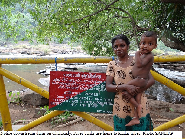
 8th April 2014, 11 year old Radhika Gurung studying in standard fourth was accompanying her sisters Chandra and Maya along the river Teesta near Bardang, Sikkim. Suddenly, without having any time to respond, all three school girls were washed away by a forceful water released by upstream 510 MW Teesta V Hydropower project in Sikkim. While Maya and Chandra were lucky to be saved, Radhika was not so lucky. She lost her life. Residents here say that NHPC, the dam operator, does not sound any sirens or alarms while releasing water in the downstream for producing hydroelectricity and villagers live in constant fear of the river.[1] Residents demanded strict action against NHPC, but no action has been taken.
 nuary 2012, a family of seven people, including a child, drowned in the Cauvery River when water was released from the 30 MW Bhavani Kattalai Barrage-II (BKBII in Tamil Nadu). The same day, two youths were also swept off and drowned in the same river due to this release.[4] There are no reports of any responsibility fixed or any action taken against the Barrage authorities or Tangedco, although it was found that there was not even a siren installed to alert people in the downstream about water releases.[5]
 s of the Chalakudy River near the Athirappilly falls in Kerala and the Kadar tribes, which traditionally stay close to the river and are skilled fisher folk too, are fearful of entering the river.
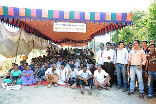
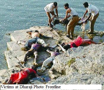 east 70 people were killed at Dharaji in Dewas district of Madhya Pradesh due to sudden release of huge quantity of water from the upstream Indira Sagar Dam on Narmada river. Principal Secretary Water Resources Madhya Pradesh inquired into the incident and found that “there was no coordination between agencies”[12]. No accountability was fixed and no one was held responsible. NHPC, who operated 1000 MW Indira Sagar Project, simply claimed that it was a case of miscommunication and that it was not aware of the religious mela in the downstream of the river. As SANDRP observed then, “ It just shows how far removed is the dam operator from the welfare of the people in Narmada as the fair annually gathers more than 100,000 people of the banks of the river. It is a scandal that no one was held responsible for the manmade flood which resulted in the mishap[13].”


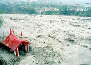


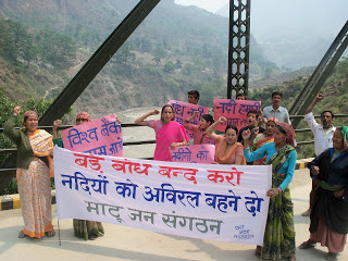
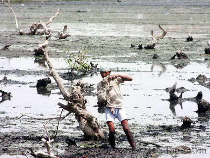


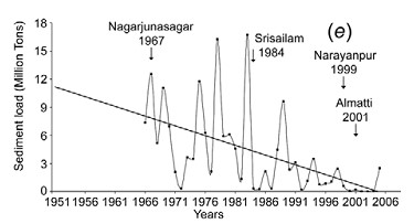
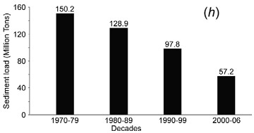
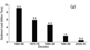
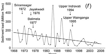

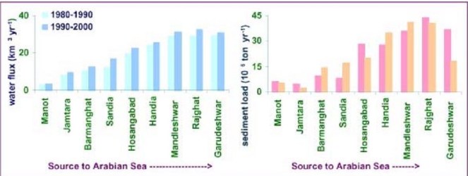
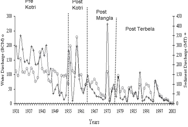

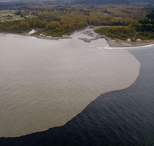

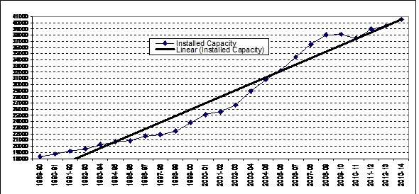


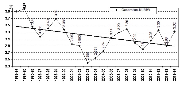
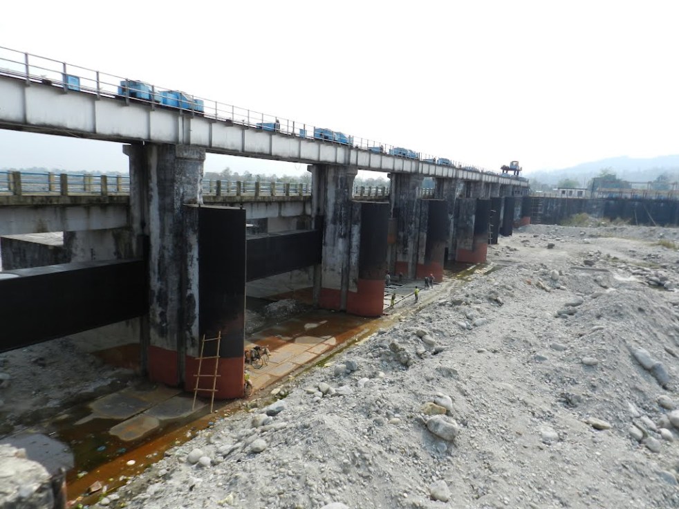
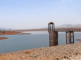

 One of the two lead coordinating authors of this report was Dr. Arun Kumar, from AHEC, IIT Roorkee. Notably, Dr. Kumar was also a part of the team which worked on Cumulative Impact Assessment of Hydropower projects in Upper Ganga basin of Uttarakhand