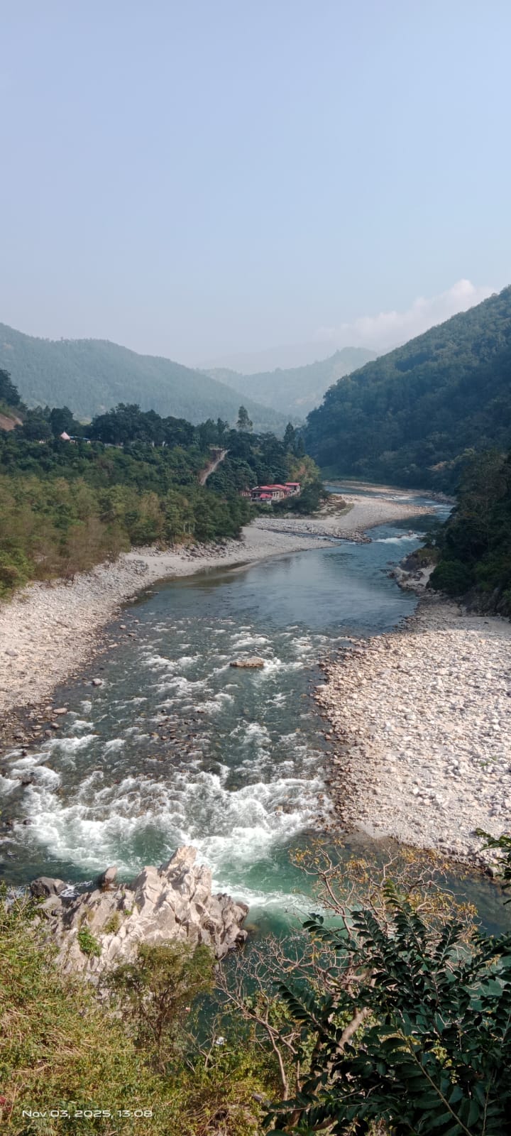
(Feature Image: Ramganga river at Marchula on Nov. 03, 2025. SANDRP)
As the year 2025 ends, reflecting on the DRP related developments over the year and even in this last DRP of 2025, one cannot but see largely pessimistic situation for India’s Rivers, Water Bodies, Hills and Mountains, Floodplains, and for the environment in general. As we saw during South West Monsoon 2025, the flood disasters have been so severe that the number of deaths in South Ais are the highest among all climate disasters of 2025 according to the just released Christian Aid report. The spread, intensity and frequency of the disasters are only going to increase, but we, including the government and the society seems to show little sincerity in dealing with this.
On the positive side, if one can call that, the uproar that came against the recent Supreme Court definition of Aravalli hills following a Union government committee’s recommendation provides a faint silver-line in the dark clouds. How useful this will be will depend on the next steps the apex Court takes in the matter after staying its own order of Nov 20 on Dec 29, next hearing to happen in new year on January 21.
It is interesting to see dam safety issue cropping up even in this lean season, in the context of Mirzapur dam. The dam safety is another issue that is bound to come up with increasing frequency, intensity and spread and here too, we see huge scope for improvement in the way we govern both the operational and structural dam safety, particularly ensuring transparency, accountability and participatory management.
Similarly the issues of Yamuna, Pollution, sand mining, wetlands and urban lakes provide little effective action in the right direction. Only the very brave will see too many positives from outgoing 2025, but let us choose optimism.
Max deaths in SW Monsoon in India Pak among climate disasters in 2025 The 2025 southwest monsoon in India and Pakistan, that recorded eight per cent more than normal rainfall, has triggered maximum fatalities among 2025’s major climate disasters, according to a new report by UK charity, Christian Aid. The South Asian monsoon was also the fifth most expensive climate disaster of the year, noted the global report published on Dec 27 in London. The report “Counting the Cost 2025” has found that heat waves, wildfires, droughts, and storms cost the world more than $120 billion in 2025 just from the top 10 disasters. The monsoon impact in India, alongside Pakistan, is ranked at fifth on financial loss. No continent was spared from crippling climate disasters in 2025, with at least one disaster in each of the six populated regions of the world finding place.
The SW Monsoon was estimated to have caused financial damages worth $5.6 billion, more than Rs 50,000 crore. Asia accounted for four of the top six costliest disasters, with flooding in India and Pakistan killing more than 1,860 people.
HYDRO POWER PROJECTS
BBMB Plans Hydrokinetic project on Nangal Canal BBMB plans a 1 MW Hydrokinetic project on Nangal Canal, the biggest such project of this scale in India. It will include four surface mounted turbines of 250 KW each, to be outsourced to Maclec firm. BBMB will buy the power at the rate of Rs 3.39 per unit. Punjab has objected, saying each state in which the canal passes can do it for itself. BBMB plans to share the power with Haryana, Punjab, Rajasthan and HP in the same share as per their existing share of power from BBMB.
Mizoram Hydro Plans The Mizoram govt plans to build two hydro projects: Rs 676 Cr, 24MW at Tuirini river about 60 km from Aizawl, work to be started soon and Rs 2400 Cr, 132 MW at Tuivai river in Saitual district near Manipur border under planning stage. The govt has 14 hydro projects with total capacity of just around 100 MW. The govt plans to privatise or outsource seven of them due to high maintenance cost.
Tribals opposing Ukiam HEP The proposed 55 Mw Ukiam hydroelectric project on the Assam-Meghalaya border is expected to submerge approximately 1.9 lakh bighas of land. This threatens to destroy the natural habitat of aquatic life and displace thousands of tribal families, leaving them homeless and jobless.
When Hydro projects are liability in Sikkim The Editorial Comment on Dec 11 2025: What India urgently needs is not celebratory rhetoric but a time-bound Himalayan Adaptation Plan. Mapping of glacial lakes must be updated annually, early-warning systems expanded to every vulnerable valley, and unrestrained hydropower expansion reconsidered. The state must prioritise watershed revival, spring rejuvenation, and climate-resilient agriculture to protect the livelihoods of mountain communities. Importantly, local voices — those who live closest to these glaciers — must shape policy, not remain passive victims… While Sikkim markets itself as an “organic, sustainable” state, it remains heavily dependent on hydropower — the very development model now threatened by melting glaciers. Dam reservoirs choke with debris, river flows become erratic, and infrastructure meant to generate clean energy becomes a liability in extreme weather.
Union Power Minister inaugurates Commercial Operation of LSHEP unit Shri Manohar Lal, Union Minister of Power, Housing & Urban Affairs, inaugurated on Dec 23 the commercial operation of Unit–2 (250 MW) of the 2000 MW (8×250 MW) Subansiri Lower Hydroelectric Project through virtual mode. The Subansiri Lower H.E. Project features India’s heaviest hydro generator rotors, largest stators and biggest main inlet valves, along with the nation’s largest aggregate processing plants, highest-capacity batching plant and first-ever use of Rotec’s Tower Belt for dam concreting in India.
The remaining seven units (250 MW each) are scheduled for commissioning in phases during 2026-27. The work on the project began way back in 2005, two years after it was approved by the Centre. The initial estimated cost of the project was pegged at Rs 6,285 crore and 2012 was set as the year of completion. However, the project work remained stalled between 2011 and 2019. The work resumed in 2019 but the cost shot up to Rs 27,000 crore.
Bhilwara Group acquires 76 MW Phata Byung HEP in Uttarakhand LNJ Bhilwara Group on Dec 25 said it has signed an agreement to acquire a 100 per cent stake in Mandakini Jal Urja, which is constructing a 76 MW Phata Byung hydro project in Rudraprayag Dist, Uttarakhand, for an undisclosed amount. The agreement has been signed through a group company, Bhilwara Energy, to acquire the entire equity holding from Statkraft IH Holding AS. The acquisition is “subject to customary conditions precedent”, it added.
J&K: Dulhasti Stage-2 gets EC The EAC recommended environmental clearance for 260 Mw Dulhasti stage-II hydroelectric project during its meeting held on Dec 19. The estimated project cost is Rs 3277.45 crore. While recommending EC, the EAC directed that a study should be undertaken five years after commissioning of the project to assess its impact on the environment. It also directed NHPC and Chenab Valley Power Projects Limited (CVPPL) to undertake a study, through a reputed govt research institute, to formulate a strategy for sustainable environmental management of the Chenab River Basin. The study will cover aspects such as scientifically robust environmental flow regimes, restoration and maintenance of channel morphology and sediment processes, protection and conservation of aquatic and riparian biodiversity, livelihood and community concerns, and integration of Marusudar River management within the Chenab basin cascade framework.
Ratle HEP controversy Jehangir Ali Sanjay Parrihar, a former village headman (sarpanch) from Kuntwara, emerged as the face of the agitation in Kishtwar after he publicly threatened the Ratle project head Harpal Singh and the human resource chief Burhan Andrabi with “dire consequences”.
Sharavathi PSP: Govt approves mitigation framework Karnataka govt has approved the framework for a wildlife mitigation plan even as the National Board of Wildlife (NBWL) has embarked on a site visit to understand the impact of works in the fragile area. Apart from quoting materials available in secondary sources, the framework doesn’t provide any details regarding the actual and site-specific mitigation measures required on the ground. In his letter to the government, Ray stated that the adequacy of the measures proposed by the framework cannot be ascertained as no scientific assessment has been conducted regarding the project impact area and potential impact of the project on the wildlife.
The approval is similar to the opaque manner in which the project has received a push at each level. The state and the Union governments have come under criticism for pushing the project without disclosing any of the crucial details.
ENVIRONMENT GOVERNANCE
The Hindu Edit: Green Washing on Aravalis … the conversation reveals the trust deficit that the government faces given its generally poor performance in addressing air pollution.
SC appointed CEC did not accept the 100 m definition of Aravalli On October 13, the Ministry of Environment, Forest and Climate Change (MoEF & CC) proposed a new 100-metre definition for Aravallis to the Supreme Court. The very next day, the apex court’s Central Empowered Committee (CEC) wrote to the amicus curiae assisting the bench that they did not examine or approve the recommendation. On November 20, the Supreme Court accepted the 100-metre recommendation of the ministry.
In its October 14 letter reviewed the CEC underlined that the definition formulated by the Forest Survey of India (FSI) should be “adopted in order to ensure the protection and conservation of the ecology of the Aravalli Hills and its range.” When asked if the CEC’s stand against the ministry’s 100-metre definition of Aravalli was conveyed to the SC bench led by then Chief Justice of India BR Gavai, amicus curiae K Parmeshwar declined to comment.
In a powerpoint presentation titled “Implications and pitfalls of the new definition of Aravalli Hill and Ranges” to the Supreme court, the amicus curiae relied heavily on the FSI material to oppose the ministry’s 100-metre definition. In the presentation, Parmeshwar pointed out the “integrity of the Aravali as a geographical feature is lost due to this (100-metre) definition”.
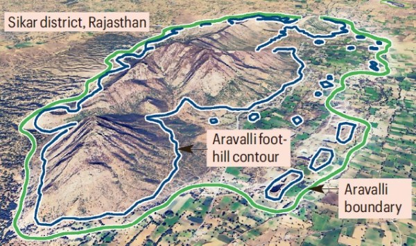
Using a map (see above) showing the Aravalli boundary as delineated according to the FSI’s definition, Parmeshwar wrote: “The blue lines represent the base or foothill contours from where hill formation begins, while the green line marks the Aravalli boundary, including its buffer area. It can be observed that multiple hillocks lie within this boundary, a phenomenon common throughout the range and not confined to any specific location.” He went on to explain, “if the proposed (100-metre) definition is applied, such hillocks will not be recognised as part of the Aravallis and may consequently be opened for mining. This would undoubtedly result in severe ecological consequences, including the further eastward expansion of the Thar Desert.”
It said this “will cause dispersal” and concluded that “the approach suggested by the MoEF&CC is vague and cannot be accepted.” On November 26, The Indian Express quoted an internal assessment — not any study — by the FSI that flagged to the ministry and the CEC that the 100-metre definition would exclude 91.3 per cent of 12,081 Aravalli Hills 20 metre or higher, spread across 15 districts in Rajasthan. While the 20 metre height cut-off is crucial for a hill’s function as a wind barrier, if all 1,18,575 Aravalli hills are considered, over 99 per cent will not make the 100-metre cut, according to the FSI’s internal assessment.
In the October 14 letter to the amicus curiae, CEC chairman and former director general (forests) Siddhant Das wrote that the CEC asked Dr Bhatt for the draft minutes of the committee’s October 3 meeting “for proper examination and for taking a considered view.” “No such draft minutes have been placed before the committee till date and no examination of the report prepared by MoEFCC has been done by the CEC. Hence, the views attributed to the CEC in the affidavit filed by the MoEF&CC are, in fact, those of Dr JR Bhatt and not of the CEC,” the letter said. The report, submitted by the ministry as part of its affidavit, was unsigned. In fact, the October 14 letter underlined that the CEC “is of the considered opinion that the definition” used by the FSI should be adopted instead.
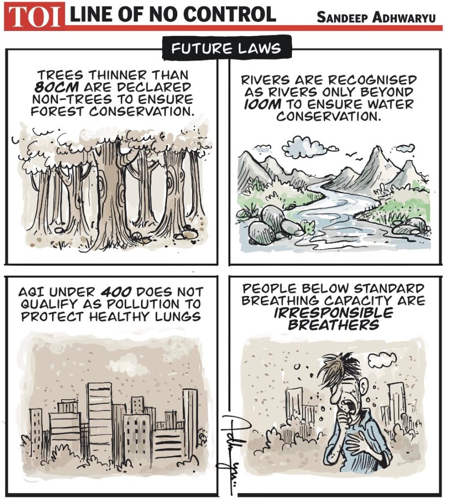
On Dec 22, Environment minister Bhupender Yadav told the media that mining is allowed in only 0.19 per cent of the entire Aravalli spanning 1.44 lakh sq km — or just 278 sq km. However, the ministry’s own data shows that this 278 sq km is the total area already under mining in Aravalli across Rajasthan, Gujarat and Haryana. The ministry is yet to address the future scope for mining and other developments in the lower segments of Aravallis once they are excluded under the 100-m definition. The minister also said that the extent of Aravalli areas covered under the 100-m definition would be known only after the ground demarcation is completed. In such a scenario, how the ministry assured the SC that more areas will be counted as Aravalli under the 100-m formula compared to FSI’s 3-degree definition.

The Aravallis and the height of judicial insensitivity The definition of the Aravallis places short-term financial gain for a few over long-term ecological and social benefit. It is crucial to revisit the definition. Nature cannot speak for itself in a court of law; when it does speak, it is outside: in the form of floods, landslides, and drought. It is a harsh reminder that at the end of the day, it is nature that is supreme; not institutions created by humans. (Ritwick Dutta)
Geologist C.P. Rajendran writes in this commentary on the geological and ecological significance of the Aravallis, and the dangers that the new order poses. The potential transformation of the Aravalli Range exemplifies this shift in agency. Its future will have profound consequences for northern India, especially against the backdrop of intensifying climate change and rising temperatures.
To fast-track leases, MoEF tells states, UTs to hold just one forest survey before mining Amid concerns that the Centre’s definition of the Aravalli hills will open the range up for mining, the Union environment ministry earlier this month ordered states and Union territories to conduct just one survey of forests to be mined, saying “repetitive” surveys caused delays and “unnecessary expenditure”. In the letter, dated December 11, the ministry said separate surveys by multiple agencies as well as the bidder delayed the execution of mining leases.
Experts, however, criticised the move and pointed out that each survey had separate objectives and unique parameters. A joint check, they argued, will not meet these standards, impinge on each department’s autonomy and will water down a crucial process baked into law to safeguard forests and green spaces.
District-wise plan in the works: Minister The Indian Council of Forestry Research and Education (ICFRE) will, in the coming days, prepare a district-wise report on which hills meet the criteria to be considered part of the Aravalli Range, but strictly for the purposes of mining, Union Environment Minister Bhupender Yadav said at a press briefing on Dec. 22.
Ban on new mining lease The Environment Ministry on Dec. 24 issued orders to the Chief Secretaries of Haryana, Rajasthan and Gujarat, asking them to enforce the Supreme Court’s direction preventing the granting of new mining leases across the Aravalli range till a management plan is finalised. Existing mines with permissions will be allowed, provided they “strictly” comply with norms.
New definition could have effects beyond mining Parts of Aravallis are designated as tiger reserves, national parks, sanctuaries, eco-sensitive zones around these protected areas, wetlands and plantations under the compensatory afforestation scheme. These areas remain out of bounds for mining or development, unless permitted specifically under the relevant wildlife and forest Acts, irrespective of their status as Aravalli Hills.
It is important to note that the new Aravalli benchmark does not exclude all landforms under a 100-metre elevation from the range. It identifies all landforms rising at least 100 metres from the local profile as Aravalli Hills. And it is only when two such hills are less than 500 metres apart that the intervening stretch — irrespective of its elevation — will also be counted as part of the range.
Disappearing Aravalli could hit India’s already strained water sources Though low and heavily eroded, they perform a critical ecological role: acting as a natural barrier that slows winds and traps dust from the Thar Desert. Their rocky ridges and forested patches help prevent vast quantities of sand and fine particles from sweeping eastward into the Indo-Gangetic plains and beyond.
EDIT Don’t mess with Aravali The fact is that no framework can offer balance between mining and conservation and ecological concerns. Short-term financial consideration can’t be allowed to override long-term ecological and societal considerations, which includes management of air pollution and groundwater conservation in the NCR. The pursuit of a “uniform definition of the Aravalli hills and ranges” itself is a fraught idea considering its varied landscape. The Aravallis is a complex, composite ecosystem that sustains wildlife reserves, lakes, wetlands, and human habitations. Let it be.
Green washing The debate on what is Aravalli reveals distrust of govt. on ecological issues. The government might cry itself hoarse that this definition of what is and is not ‘Aravalli’ is specific only to the purposes of deciding mining leases and not, say, on permission for tree cutting, residential leases and agriculture. However, without transparency, no amount of afforestation or accusing the Opposition of misinformation will work.
Over 5,000 cases pending in NGT Data revealed in Parliament shows a high number of pending cases in the National Green Tribunal, a specialised statutory body dedicated to resolving environmental disputes. Together, all five benches of the NGT have over 5,000 cases pending in the courts, Kirthi Vardhan Singh, Minister of State for Environment, Forests, and Climate Change told Parliament on December 15. The Principal Bench, based in New Delhi, reported the highest pendency from 2020 to 2025, with 1939 pending cases as of November, the data showed. The Western bench in Pune had the second highest pendency, at 1933 cases over the same time period, followed by the Southern bench in Chennai (846 pending cases), the Eastern bench in Kolkata (411 pending cases) and Central zonal bench in Bhopal (320 pending cases).
NGT stalls Govt move to tap Rs 400 cr from Karnataka SPCB The state govt’s efforts to get over Rs 400 crore from the Karnataka State Pollution Control Board (KSPCB) to fund works related to prevention of man-animal conflict has hit a legal hurdle, with the NGT taking up a suo motu case. Of the Rs 426 crore sought, Rs 300 crore was to fund construction of railway barricades to prevent man-elephant conflict.
The Rs 126 cr was meant for works for building coastal resilience under a climate change mitigation program. The report had also noted that diversion of KSPCB funds was not backed by laws, especially Water and Air Acts. In addition, the report pointed to the NGT order in 2023, which questioned the Punjab govt’s attempt to divert Rs 250 cr. Following the notice, Punjab made a U-turn and decided not to transfer the funds. Within KSPCB, officials had said the board not only requires autonomy but also needs to incorporate measures to streamline the board.
DAMS
Unanswered Questions about Sardar Sarovar Dam Vidhyut Joshi, once a supporter of Sardar Sarovar Project says: “Yet, even decades later, many of the original questions raised in the Gujarati account remain unresolved. How effectively has irrigation capacity translated into actual irrigation? Have water users’ associations functioned as envisioned? Has rehabilitation ensured not merely compensation but restoration of livelihoods? And, crucially, has political appropriation of the project erased the long history of debate, dissent and sacrifice that made its completion possible?”
“The Narmada project’s true legacy does not lie only in canals, turbines or reservoir levels. It lies in the uncomfortable truth that India’s development choices are never neutral or purely technical. The project passed through constitutional tribunals, mass movements, courtrooms, expert committees and street protests precisely because it sat at the intersection of federalism, ecology, social justice and economic growth. To reduce this history to a single leader, party or narrative of unqualified success is to deny the complexity of democratic development
“The strongest lesson of the Narmada project is therefore not that large dams are inherently good or bad, but that development without sustained public scrutiny becomes authoritarian, and resistance without engagement risks stagnation. Remembering the project’s contested journey—from the abandoned Bharuch dam proposal of 1946 to the fiercely debated Sardar Sarovar—forces us to confront a larger question: whether India is willing to acknowledge that progress must be measured not only by what is built, but by who bears the cost, who decides, and who is remembered once the waters rise.”
Song Dam Worsens Climate Vulnerability Planned to solve Dehradun’s water shortage, the Song Dam Drinking Water Project’s construction practices have altered the river’s behaviour, villagers say. Environmental groups also pointed to ongoing mining and drilling on the riverbed, and the proposed felling of thousands of trees will destabilise the valley further.
Experts describe this as a classic example of maladaptation: when an intervention meant to reduce risk ends up heightening vulnerability instead. In simple terms, maladaptation occurs when a response to one stress, such as water scarcity, unintentionally worsens others, like flood risk, ecological instability or seismic vulnerability. In the case of the Song dam, Vishal Singh, Executive Director of the Centre for Ecology Development and Research (CEDR) in Dehradun, said the project may be creating new risks for river-bank communities even before it is complete.
The rapidly changing behaviour of the river raises questions about whether the dam can achieve its purpose. “When the project research was done, initial investigations in the early 2000s and detailed studies completed by 2011, the river’s morphology was very different. Even today, the irrigation department lists the Song as a perennial river, but on the ground it behaves more like a seasonal stream, with water levels falling sharply,” said Dehradun-based environmental activist Reenu Paul. “Every monsoon, the river brings down rubble from unchecked construction in the upper reaches, causing severe damage downstream, as we saw this year. These erratic episodes will only increase. By the time the project nears completion, the Song may not even hold enough water for the dam to function.”
DAM SAFETY
Mirzapur: Water leakage from the Ahraura Dam Water leakage from the main canal gate of the Ahraura Dam has become a major headache for approximately 10,000 farming families in the area. The leakage has flooded their fields ruining their crops and causing significant water wastage. Affected farmers staged a protest on Nov 9 and after discussions with the administration, the farmers decided that if the Irrigation Department did not resolve the seepage problem within the next three days, they would block the highway.
Sharda Prasad Mishra, president of the Jai Jawan Jai Kisan Samiti, told IWP, “Water is leaking from the Ahraura dam as well as the Dongiya and Upper Khajuri dams. Due to the Irrigation Department’s indifference and lack of timely maintenance, the condition of the dams is deteriorating day by day. Silt accumulation and leakage have become common. The Irrigation Department is failing to prevent water wastage. The only source of water for farmers for farming is the dam water, but the manner in which the dam water is being drained is worrying.”
The dam is also at risk due to years of blasting at Mirzapur’s stone quarries. Reports of cracks in the dam have been circulating from time to time. Many houses and shops in the area have been damaged. Despite the damage and injuries to several people, blasting has not been curbed. The situation is such that blasting now threatens the Dhekwa Dam and the school. This allegation is made by Harishankar Singh, Executive Engineer of the Irrigation Department’s Chunar Division.
On Nov 6, he wrote to the DM, demanding an immediate halt to illegal mining near the Dhekwa Dam. In the letter, he informed the DM that during a site inspection of the Dhekwa Dam by the Assistant Engineer and Junior Engineer, they found that blasting was taking place in the village of Lahora in Tehsil Chunar, just 150 meters from the Dhekwa Dam. Villagers told him that the blasting causes severe vibrations in their homes, causing anger among the villagers. There is a strong possibility that the Dhekwa Dam will also be damaged. No action has been taken on his letter yet, and mining continues.
INTERLINKING OF RIVERS
Karnataka gives nod for DPR of Bedthi– Varada Link Deputy CM DK Shivakumar on Dec 24 said the state had given in-principal approval for the Centre’s proposal for preparation of the Detailed Project Report of Bedthi–Varada (Hirevaddatti) intra-state link project. Of the total project cost of Rs 10,000 crore, the Centre will spend Rs 9,000 cr remaining Rs 1,000 cr by the State.
Allocate 40-45 TMC water to Karnataka under river-linking project Deputy CM on Dec. 24 said that he has urged the Centre to allocate at least 40-45 TMC of water to the state under the river-linking project. He said the state has also sought the release of an additional 5 TMC of water to the Bhima river basin.
Karnataka seeks larger water share in river linking projects The Deputy CM said the meeting, chaired by the Union Jal Shakti minister CR Patil, discussed the Godavari-Cauvery and Bedthi-Varada River linking projects. “In the first phase of the Godavari-Cauvery linking project which has a capacity of 148 tmcft, Karnataka has been allocated only 15.9 tmcft. We have asked for details on the coverage and use of this water,” he said. Shivakumar said Karnataka has been allotted 18.5 tmcft under the Bedthi-Varada river linking project.
RIVERS AS NATIONAL WATERWAYS
MOU for transport along Jhelum river in Srinagar On Oct 31, a Memorandum of Understanding (MoU) was signed between the Regional Transport Officer (RTO), Govt of Jammu & Kashmir, and the Inland Waterways Authority of India to develop an urban water transport system in Srinagar along the lines of the Kochi water metro. The proposed Rs 900-crore project plans to begin water transport connectivity through electric-hybrid boats for local passenger movement. There will be five routes with 10 terminals on the Dal lake and two routes with eight terminals on the Jhelum.
The Kochi water metro, the first of its kind in India, was launched in Dec 2021. It consists of 23 battery-powered electric boats which ferry people on its numerous waterways to important destinations in the city. Eventually it will take people along 15 routes, connect 10 islands and traverse 75 km on 78 electrically propelled hybrid ferries.
What Assam can learn from Kerala’s waterways The drive for big infrastructure is understandable but one must ask: Who is benefiting? Where do the people figure? (By Sanjoy Hazarika)
URBAN RIVERS
How people power reclaimed Vishwamitiri for Vadodara From building a coalition against the Vishwamitri Riverfront Development Project to getting it scrapped – a rare success – people’s movements have interwoven passionate activism with law, science, and data. Their collective engagement and dogged sense of purpose made all the difference. Activists and experts were appointed by the Gujarat State Human Rights Commission this year to a committee overseeing the Rs 1,200-crore flood mitigation project; besides, people do on-ground monitoring, record official work, track plans and progress, and document irregularities.
Rivers, Cities and People The Friday Waters, Book Reading session on, ‘Rivers, Cities and People- Social Challenges of Urban Waterfront Development in Asia’, focus is on discussing the making of the book published by Routeledge in May 2025. The book looks into some of the recent initiatives for river restoration and riverfront development intended to contribute to making Asian cities resilient, inclusive and less polluted. Both speakers highlight the interdisciplinary perspective to assert that insufficient consideration of social issues in the planning and management of urban riverscapes lead to social exclusion.
Residents urge TC to speed up Cauvery riverfront project To curb the dumping of waste, including ritual offerings, into the Cauvery that flows for 16 km within Tiruchy corp limits, the civic body came up with the riverfront development project on the southern banks running between the Thillainayagam bathing ghat and the Chennai Bypass via Odathurai earlier this year. Later, the scope of the project, which aimed at developing the stretch of about 1.5 km, was expanded with the inclusion of an 850-metre stretch between Geethapuram bathing ghat and the Amma mandapam bathing ghat on the northern banks of the river. The estimate, which was originally at Rs 15 crore when announced in the corporation’s annual budget, was also revised to Rs 50 crore.
RIVERS
Eco-Hydrology In this episode, host Veena Srinivasan speaks with Jagdish Krishnaswamy to explore the science that connects hydrology, ecology, and the people who depend on India’s rivers and landscapes. From the Western Ghats to the Himalayas, from springs to large reservoirs, this episode dives into decades of pioneering field research, where data collection meets cutting-edge science.
They further discuss the complex “sponge” effect of forests in the Western Ghats and how exotic plantations impact water infiltration. They travel to the Eastern Himalayas to understand the drying of springs and the nuances of restoration beyond simple tree planting. The conversation also highlights the concept of “Hungry Water,” the critical importance of sediment, and the struggle for survival of the Gharial in the face of flow alterations.
Gandikota canyon: The neglected wonder in our backyard The geological wonder is India’s answer to the Grand Canyon in the U.S. The steep red sandstone cliffs, hemming in the Penna river as it flowed its serpentine course, make both sunrise and sunset a sight to behold. Similarly, historical structures like a fort, a temple and a mosque cast another layer of attraction, especially for those into art, architecture and archaeology.
The place currently lacks designated viewpoints, pathways and guidance for visitors. Access points are unsafe, and visitors embark on a risky trek up to the view point. It also lacks adequate information boards, drinking water facilities, public toilets and garbage bins. Visitors littering even heritage spots is also a cause of concern. The spot has also witnessed an unregulated mushrooming of private resorts that encash on the weekend rush.
Mintdu River Crisis: Construction Debris, Reduced Flow The Mintdu River in Meghalaya has been the lifeline for water, agriculture, and fish-based livelihoods for Jowai and surrounding villages. But unregulated construction and debris dumping associated with the Jowai bypass road project have plunged this vital waterway into a deep environmental crisis.
Drought risk & hydrological changes in Ganga Basin Conclusions: This study provides a comprehensive analysis of hydroclimatic trends and drought variability across the Ganga River Basin from 1980 to 2020, using the Modified Mann-Kendall test and Sen’s slope estimator. The results reveal a significant reduction in precipitation, particularly during the monsoon, post-monsoon, and winter seasons, with a Sen’s slope indicating declines of up to −3.5 mm/year in central regions.
The annual number of rainy days has decreased basin-wide, averaging around 60 days per year, with declines of 10–15 days observed in several districts. Extreme precipitation events, as measured by the R99 index, have increased in the northeastern basin by more than 0.25 days/decade, while light rainfall events (R1, R5) have shown a notable decline. Minimum temperatures exhibit statistically significant increasing trends in all seasons, with warming rates reaching up to +0.04 °C/year in some areas, whereas maximum temperature trends are more variable. Evapotranspiration has increased by +2.1 to +2.7 mm/year, particularly during the pre-monsoon season, contributing to elevated evapotranspiration stress even in wetter periods. Drought indices such as SPI-6 and SPI-12 show that central and southern regions of the basin experience moderate-to-severe droughts with probabilities exceeding 30 %, while SDI trends confirm increasing streamflow drought severity, especially in post-monsoon and dry months.
These findings highlight the intensifying water stress in the basin due to declining rainfall, increasing temperature, and rising atmospheric demand. To address these emerging challenges, region-specific adaptive water management strategies must be implemented. Recommended actions include integrated watershed management to enhance natural recharge, promotion of rainwater harvesting and managed aquifer recharge, crop diversification toward water-efficient varieties, and expansion of micro-irrigation systems. Furthermore, the development of a robust drought early warning system and the integration of climate trends into water allocation policies are essential to support long-term water and food security in the Ganga River Basin.
Abstract: Droughts pose significant threats to water resources, agriculture, and livelihoods in the Ganga River Basin, a region highly dependent on monsoon rainfall and home to over 500 million people. Despite increasing climate variability, comprehensive assessments integrating multiple drought indicators remain limited. This study aims to address this gap by analyzing long-term trends in precipitation, temperature, and evapotranspiration (ET) from 1980 to 2020, and evaluating drought conditions using the Standardized Precipitation Index (SPI), Streamflow Drought Index (SDI) at 3, 6, and 12-month time scales, and Evaporative Stress Index (ESI) at multiple time scales.
Results reveal significant declining trends in seasonal precipitation and rainy days, coupled with rising ET, particularly during the monsoon and pre-monsoon periods. Minimum temperatures show consistent increases across seasons, while maximum temperatures exhibit moderate changes. Drought indicators demonstrate increasing frequency and severity of hydrological and meteorological droughts in central and southern regions of the basin. The findings highlight the urgent need for region-specific adaptive water management strategies to mitigate the increasing drought risks and ensure sustainable water availability in the Ganga River Basin.
Region-specific adaptive water management strategies urgently needed The findings show that water stress in the basin is intensifying due to declining rainfall, increasing temperatures, and rising atmospheric demand. To address these emerging challenges, region-specific adaptive water management strategies must be implemented. These can include integrated watershed management to enhance natural recharge, promotion of rainwater harvesting and managed aquifer recharge, crop diversification towards water-efficient varieties, and expansion of micro-irrigation systems.
Development of a robust drought early warning system and the integration of climate trends into water allocation policies will also be crucial to support long-term water and food security in the Ganga River Basin.
Will Mirzapur power plant leave farms & people thirsty? This is the story of the environmental crisis looming over the Windham Falls and surrounding forest area in Mirzapur. This crisis involves the depletion of water resources, the drying up of forests, and harm to hundreds of species of animals and birds in the forests… all brought about by the proposed power plant.
‘A holistic urban water policy needed to revive the Yamuna’ Bhim Singh Rawat, SANDRP: “Yamuna needs its flowing water back but the govt has done exactly the opposite by funding dams upstream to deprive the river of its very essence. Before the monsoon retreated, the river again swelled unusually, reclaiming the parts of its abused and grabbed floodplains, especially behind the riverfront and beautification projects. Crores spent on ‘beautification’ were undone by the river floods but the government is back with the misadventure of floodplain privatization and commercialization. This is not the way a river is ‘cleaned’. Instead, we need to have a holistic urban water policy but I fear that the same cycle of events and decisions will unfold next year.”
3 months of data on Yamuna water quality missing Data on water quality of the river Yamuna and of Delhi’s STP, CETPs and drains – mandated to be posted at least once a month – has not been updated for over three months. The latest available report on the DPCC website for the Yamuna and major drains dates back to October. The absence of current data is particularly concerning as the lean winter season – characterised by reduced water flow and lower temperatures – typically leads to a deterioration in river water quality, including increased frothing.
Experts stress that transparency is critical, especially now, to assess pollution levels when the river is most vulnerable. Activists and researchers warn that the data gap undermines efforts to track river health. “We know the water quality worsens significantly in winter. Typically, one can compare it to last year to see whether there is an improvement or not. Missing data sets a poor example for river governance,” said Bhim Singh Rawat, a Yamuna activist, and of the SANDRP.
DPCC not releasing reports No reports have been released for the STPs since Sept, even though 8 STPs were inaugurated on Oct 9 after their upgrade work was completed. The data for these STPs has also not been made public. Environmentalists are expressing their displeasure over this. Pankaj Kumar of Earth Warriors says that transparency is crucial. People should receive regular updates on the pollution levels in the Yamuna. BS Rawat, of the SANDRP, says that the DPCC should address the shortcomings in the reports and release them regularly. They should also increase the parameters for testing. DPCC member Dr. Anil Gupta says that he will raise this issue in the next committee meeting. No committee meeting has been held since July.
Concern over excessive use of defoamer in river Activist Pankaj Kumar has written to LG VK Saxena and chief minister Rekha Gupta, raising concerns over the prolonged and excessive use of defoamers in the River Yamuna. Kumar noted that while defoamers were previously used briefly around Chhath Puja, this year their use began on Oct 15 and continued for nearly 60 days, warning that such sustained use could have long-term ecological consequences. Kumar warned that constant spraying could reduce oxygen transfer, disrupt microbes and cause accumulation of non-biodegradable silicone and silica in sediments, harming aquatic life. Bhim Singh Rawat, of the SANDRP, called for a standard operating procedure on defoamer use and urged the CPCB and the NMCG to study its ecological impact. A senior govt official confirmed that instructions have been issued to halt the use of defoamers in the river.
Concerns over ‘excessive, prolonged spraying of defoamers Earth Warrior group maintained that the prolonged spraying of defoamers in 2025 marked a departure from the shorter duration of spraying observed in the previous years. While highlighting that the use of defoamers in the last three years–2022-2024–was restricted to around 7-10 days during the Chhath Puja period, the group alleged that in 2025 the spraying began in the second week of October and continued well beyond Nov, including on days when little or no visible foam was present on the river surface.
IIT panel is struggling to review STPs discharging waste into Yamuna Nearly four months after the NGT asked the IIT, Delhi, to check whether the sewage discharged into the Yamuna river after treatment is safely disinfected, the expert panel is facing hurdles in conducting the review. The exercise is crucial because the DJB operates 37 STPs along the Yamuna. Of these, 11 use chlorination disinfection systems, 14 have UV disinfection systems, while the rest are still undergoing technological upgradation. Concerns have been raised in the past if the bacterial loads, particularly faecal coliform levels, are brought to safe limits before discharge.
But IIT Delhi has told the NGT that it is unable to proceed with the assessment because crucial data and access to the STPs have not been provided. In a letter submitted earlier this month, the institute said its expert committee is still awaiting permission for site visits, nomination of nodal officers by DJB to coordinate plant-level information, and operational and microbial performance data from both DJB and the Delhi Pollution Control Committee (DPCC). IIT Delhi said it had formally sought the required information through a communication dated October 27, but the data submission remains pending.
The committee also flagged that it has not received a DPCC report from July this year referred to in earlier NGT orders. It further pointed out that while DPCC has reported non-compliance with prescribed microbial standards at 14 STPs, there is no reliable data available on the effectiveness of the UV disinfection systems installed at these plants. A realistic assessment, the committee said, requires microbial quality data at both the inlet and outlet of UV channels.
26 of 27 drains fail water quality norms: DPCC The report for the month of October, found that of the 27 drains assessed, 10 had no flow or had been tapped. Of the remaining 17 drains, only one – the Shastri Park drain – met the prescribed water quality standards. Senior government officials said the DJB is planning to step up surveillance of water quality in 75 drains and sub-drains that carry untreated effluents into the river.
Diwan Singh, an environmental activist said that these drains and sub-drains had been monsoonal nallah that fed Yamuna but they have been rendered into sewage carrying channels. “We need to tackle the pollution sources at sub drain level by treating the drain as a system in itself. We can used twin strategy of setting up decentralized treatment plants as well as in situ treatment of drains but the sources need to be tapped. It does not take many tests to see that Delhi’s drains are carrying extremely polluted wastewater.”
Leaking Pragati Maidan tunnel to get 3.7 cr waterproofing The Pragati Maidan tunnel, built at a cost of Rs 777 crore and funded by Centre, was executed by PWD, which engaged Larsen & Toubro as the engineering, procurement and construction contractor responsible for design, execution, maintenance and repairs. However, waterlogging and seepage were observed soon after the tunnel became operational.
A five-member PWD committee, formed in March 2024, submitted a report in April identifying the factors behind the recurring waterlogging. However, no preventive measures were taken before the onset of the monsoon. The expert panel pointed to coordination gaps arising from multiple agencies working on different components of the Pragati Maidan redevelopment. While the tunnel network falls under PWD, Bharat Mandapam is managed by ITPO, and water infiltration from underground parking ramps and branch tunnels has led to frequent flooding and closures after spells of rain.
PWD has attributed the problem to an incomplete drainage system within the Bharat Mandapam campus. Among the committee’s key recommendations was an immediate halt to the discharge of water by civic agencies, particularly NDMC, in areas surrounding the tunnel — a practice identified as a major contributor to water accumulation.
SC-led panel finds lapses in Noida’s claims A joint committee set up by the Supreme Court to verify Noida Authority’s claims on controlling sewer discharge into the Yamuna through Kondli irrigation canal has found significant gaps in the city’s submissions. In its report submitted on Dec. 23, a team comprising CPCB and UPPCB officials flagged “gross misrepresentations” after ground inspections. The Supreme Court is expected to take up the findings on Dec 3 in a civil appeal filed by Noida Authority against the NGT’s Rs 100-crore environmental penalty for allowing untreated sewage to flow into the Kondli canal and ultimately the Yamuna.
The NGT had also imposed Rs 50-crore fine on the DJB for releasing untreated sewage into the Yamuna. In Nov 2022, the SC stayed the NGT orders. In Aug, it directed the CPCB and UPPCB to verify the claims of compliance by Noida and DJB. Noida, in its reply, has said a lease deed for 16,000 sqm of land in Sector 62 had been executed in favour of Nagar Palika Parishad Khoda-Makanpur on Nov 29, 2024.
The case dates back to 2018, when environmentalist Abhisht Kusum Gupta filed a petition before the NGT over Yamuna pollution. In August 2022, the tribunal imposed environmental compensation on Noida Authority and the Delhi Jal Board. Noida challenged the order in the Supreme Court, which stayed the penalty but directed the authority to comply with the NGT’s directives outlined in paragraph 29 of its judgment.
RIVERS BIODIVERSITY
Gangetic dolphin found dead A 5 feet long and 150 kg dolphin was found dead in the Ganges River at Kalupur Ghat in the Suhawal police station area on Dec. 23. The forest department team has retrieved the dolphin and begun an investigation. It has been sent for a post-mortem examination. An investigation is underway to determine the cause of death. Dolphin average lifespan is approximately 28 years.
Heavy metals, microplastics found in fishing cats A new study found chromium and lead in all fishing cat scat samples across four sites in the Sundarbans mangrove ecosystem in West Bengal. Rising pesticide use, fertilisers and plastic pollution in the Sundarbans are increasing heavy metal and microplastic loads in wetlands. Scientists warn that contamination in fishing cats signals risks to human health too, urging stricter effluent control, better sewage systems and reduced dependence on harmful agrochemicals.
Tainted Water Located about 100 kms north of Mumbai, Tarapur is one of Maharashtra’s largest industrial hubs—and among its most polluted. Built along the coast, the industrial estate sits next to fishing villages where generations have depended on the sea for their livelihoods. This film journeys into those villages to document what residents say is a long, ongoing struggle with industrial pollution, declining fish catch, and worsening health.
SAND MINING
Bharuch fisherfolk demand cancellation, review of Narmada Sand mining permits The Bharuch District Fisherfolk Association has submitted a formal representation to the State Environment Impact Assessment Authority (SEIAA), Gujarat Pollution Control Board, and the District Environment Impact Assessment Authorities (DEIAA) of Bharuch, Narmada and Vadodara, seeking a review and cancellation of Environment Clearances (ECs) granted to sand mining leases located within the active flow of the Narmada river.
The association has alleged that several sand mining leases were granted or renewed based on outdated maps, some dating back to 1995, without verifying the current ground situation. According to the representation, changes in the river’s course over the years have resulted in several lease areas now falling within the river’s active channel, where sand mining is prohibited under environmental laws and guidelines. The submission further alleges that illegal sand extraction using dredging machines mounted on barges and mechanised boats is continuing in the Narmada river, including at night.
Illegal mining continue in the Son River The NGT has imposed a fine of Rs. 10,000 on the District Magistrate of Sonbhadra for the delay in investigating the matter. Reports indicate that a large amount of sand is being illegally mined in the area due to collusion between the mining mafia and government officials.
Yamuna sand mining: NGT panel finds major violations A NGT-ordered inspection of the Yamuna floodplains lying between Delhi and Ghaziabad has found largescale violations by miners, corroborating a TOI report on Nov 30 last year about an embankment being built across the river to illegally dredge sand. The joint committee report, submitted to NGT after surprise inspections on both Delhi and UP sides of Yamuna earlier this month, pointed out that though the mining lease was legal, the mining area breached legal boundaries with construction of illegal ramps. Miners, it added, operated heavy machinery within the river’s flow and ignored Delhi-NCR’s GRAP rules, continuing operations even during periods when all mining activities were prohibited to curb pollution.
Sand mining in Dhasan: NGT rejects plea challenging cancellation of clearance The NGT, Principal Bench, New Delhi, has dismissed an appeal challenging the cancellation of environmental clearance granted for sand mining in the river Dhasan in Jhansi district. The bench comprising the tribunal’s chairperson Justice Prakash Shrivastava and expert member A Senthil Vel on December 24 held that the appeal was barred by limitation under Section 16 of the National Green Tribunal Act, 2010, and that the tribunal had no jurisdiction to condone delay beyond the statutory outer limit of 90 days.
Aravali Mining: 5 rivers have dried up We don’t have water even 2000 feet below the surface; earlier, due to the hills, water was available at 200-300 feet. Dumpers belonging to the mafia operate in 18 villages across 5 panchayats, putting pressure on people to abandon their homes and land. Rivers like Banas, Gambhiri, and Sahabi, which used to flow perennially, are on the verge of extinction. This is the plight of the people whose villages, homes, and agricultural land are located around the Aravalli mountain range. Now, mining mafias have taken over.
For the past 15-20 years, so much mining has taken place here that people have been forced to leave their villages. Dumpers are running over people. The mafia is openly firing weapons, but now the danger has increased even further. Recently, the Supreme Court has given a new definition of the Aravalli mountain range, according to which only hills higher than 100 m will be considered part of the Aravalli Hills. This definition has opened new doors for the mafia. Experts say that excessive mining has already created 12 large gaps in this mountain range, allowing the desert to encroach towards Delhi. Now, the consequences will be more severe.
Khari River: NGT orders inspection of mining site The NGT has directed the Rajasthan Pollution Control Board to visit the mining lease area & check whether environmental clearances, operating permits, and environmental standards are being followed. During the hearing, the NGT also noted that the obstruction created in the flow of the Khari River has now been removed.
The miner has assured the tribunal that further mining work will be carried out only under the environmental clearance, CTO conditions, mining plan, and environmental regulations. The NGT has taken a strict stance on mining activities in the Gulgaon Gram Panchayat area of Sawar block in Kekri district of Rajasthan. This case has been before the tribunal for a long time. Earlier, on November 19, 2024, the NGT had constituted a joint committee and ordered an investigation into the compliance of environmental clearances and consent conditions by the mining leaseholders.
WETLANDS, LAKES, WATER BODIES
Impacts of anthropogenic activities on 4 wetlands in Kashmir Abstract: Wetlands in Kashmir are increasingly threatened by anthropogenic pressures like urban expansion, waste disposal, grazing, and tourism. This study assessed the impact of such disturbances on the soil physico-chemical and microbial properties of four major wetlands—Hokersar, Anchar, Manasbal and Shallabugh—between 2019 and 2021. The investigation reveals that anthropogenic disturbances exert a substantial influence on the soil physicochemical properties of Kashmir’s wetlands.
From bird sanctuaries to polluted basins, a new scientific study shows how everyday human activities are quietly changing wetland soils in Kashmir, threatening biodiversity, livelihoods, and long-term water security. The study makes one thing clear. The future of Kashmir’s wetlands is being shaped not just by climate change, but by everyday human actions. Soil degradation is a slow process, but its impacts are lasting. Protecting wetlands means protecting the invisible life beneath them. Without timely action, Kashmir risks losing ecosystems that have supported water, wildlife, and livelihoods for generations.
GROUNDWATER
Rajasthan water risk for beverage giants In Rajasthan, global beverage companies face shrinking water supplies, strict government rules, and local anger as many residents receive piped water only once a week.
URBAN LAKES, WETLANDS
NGT directs DWA to standardize waterbody reports The NGT has directed Delhi Wetland Authority (DWA) to compile and circulate a comprehensive report format to all land-owning agencies for details of every waterbody under their control. The tribunal noted that reports submitted by various agencies had revealed an alarming picture. Several waterbodies had vanished or dried up. Others were encroached upon. It said in an order dated Dec 15, which combines three different cases on wetlands based on media reports, including one from TOI titled “10 wetlands in Asola to conserve rainwater” published on March 12, 2024. It has directed the wetland authority to initiate action against violators and submit a detailed action-taken report at least a week before the next hearing. The matter has been listed for March 10, 2026.
NGT panel impose ₹5 lakh fine on Powai lake pollution NGT mandated joint committee recommended that the BMC pay a penalty of Rs 5 lakh per month per inlet if it violates its new action plan to prevent untreated sewage from entering Powai lake. The recommendation formed part of the joint committee report submitted to the NGT, which is hearing a case on the continued discharge of untreated sewage into the lake. Following an NGT ruling in a petition by Vanashakti in 2021, the Maharashtra Pollution Control Board (MPCB) issued several directions to the BMC to stop sewage inflow, which were not complied with.
The fresh case began when Powai resident Dr Rakesh Bakshi sent a letter-petition to the tribunal in March 2025 highlighting the lake’s condition. The NGT bench noted that the BMC had not filed its response to the tribunal’s notice dated Sept 19, 2025. The civic body was given two more weeks to submit its reply. The next hearing is scheduled for Feb 12, 2026.
Bengaluru’s Saul Kere facing threats Unchecked urban growth endangers Bengaluru’s lakes. One such lake, Saul Kere, faces threats from sewage inflow and illegal construction. Unless the sewage inflow is stopped, encroachments removed, and all illegal works halted, Saul Kere may soon lose its wetland character altogether. What was once a sanctuary for birds and biodiversity could become yet another example of how Bengaluru’s lakes are being engineered to death.
Chennai’s 6th reservoir project to take off soon CM M.K. is likely to lay foundation stone for the ₹350 crore project along East Coast Road and Rajiv Gandhi Salai near Thiruporur in the Kovalam basin. With a capacity to store 1.65 thousand million cubic feet of water, the new reservoir that is to be created covering land parcel between Thiruvidanthai and Mamallapuram would be spread over an area of 4,375 acre under the phase I.
Tanker caught dumping sewage into Osmansagar reservoir On Dec. 24 a private septic tanker was caught while attempting to dump untreated waste into the protected Osmansagar (Gandipet) reservoir, near Himayatnagar village within Moinabad municipality limits. Patrolling staff of the Hyderabad Metropolitan Water Supply and Sewerage Board (HMWSSB) intercepted the tanker near FTL Point No. 428 while it was attempting to discharge septic waste into the reservoir. Osmansagar supplies around 25 million gallons per day to several localities in both the old city and new city areas.
According to officials, the tanker, bearing registration number TG11 T1833, was operating illegally and was not registered with the Water Board. It was also found to be displaying the HMWSSB logo without authorization, allegedly to mislead officials and evade checks. The driver, identified as Ramavath Shiva Naik (33), reportedly told officials that he was acting on the instructions of Niranjan, a resident of Himayatnagar.
Toxic landfill waste is affecting livelihoods around Anchar lake As pollution from toxic waste spreads across canals and fields, families who relied on Anchar Lake for food and income face shrinking harvests, vanishing fish, and broken promises of waste management reforms.
URBAN WATER
Resistome profiling and bacterial community structure of semi-urban gutter ecosystems of India This study suggests the presence of antibiotic-resistant bacteria with antibiotic resistant metabolic pathways, and beta-lactamase genes in urban gutter water, which could be harmful to both human health and environmental ecosystems.
Why this matters The findings from Roorkee’s urban gutters are more than a local concern; they are smaller beginnings of a bigger global crisis. Bacteria armed with beta-lactamase genes and resistant metabolic pathways can turn environments into hotspots of antibiotic resistance. This isn’t just a medical challenge. It’s an environmental one. Resistant microbes don’t respect boundaries — they flow from drains into rivers, seep into soils, and slip into food and water systems. Tackling antimicrobial resistance (AMR) therefore requires holistic action that involves:
8-year-old dies amid suspected water contamination An eight-year-old boy, a resident of the Prestige Falcon City apartment off Kanakapura Road in south Bengaluru, died on Nov. 27, three days after being admitted due to prolonged diarrhoea. Residents of the apartment, who have been falling ill regularly and believe water contamination is behind their deteriorating health, are alleging the same cause for the child’s death.
The long road to a water-secure future in Hyderabad Hyderabad is chasing rain, literally. With the Hyderabad Metropolitan Water Supply & Sewerage Board rolling out citywide rainwater harvesting, the goal is to refill aquifers and curb dependence on tankers. But cultural apathy, poor upkeep and fragmented community action threaten to drain these efforts dry, finds B. Pradeep.
Delhi GW case: NGT deadline lapses Nearly a year after the NGT ordered a probe into the alleged illegal groundwater extraction in Central Delhi’s Paharganj, involving 536 hotels and guest houses, the Delhi government has informed the Tribunal that a Divisional Commissioner-level enquiry is yet to be completed. The green court has been told that the inquiry is at an advanced stage and is examining possible dereliction of duty by officials.
Over 20% of 2023 samples had nitrate levels above safe limit: Board tells NGT Over 20% of groundwater samples collected across Delhi in 2023 had nitrate levels above the safe limit of 45 mg/L, the Central Groundwater Board (CGWB) told the NGT. The highest nitrate reading recorded in Delhi reached 994 mg/L, which is over 22 times the permissible limit. The CGWB’s 2024 annual groundwater report, which was released in December last year, was recently presented in an ongoing case before the NGT. The report, which analysed samples collected over the previous year, showed that seven of Delhi’s 11 districts, including New Delhi, North, Northwest, South, Southeast, Southwest and West Delhi, recorded nitrate levels above the safe limit.
WATER POLLUTION
Water pollution in India: A comprehensive overview Water pollution in India now affects drinking water, farming, and aquatic life, demanding urgent action, stronger policies, and community participation.
2 die in Tiruvallur Residents of Karlambakkam blocked RK Pet – Pallipet road near Tiruttani on Dec. 27 after two persons died in two days, allegedly due to contaminated drinking water. They claimed that the drinking water supplied by the panchayat was contaminated and had caused diarrhoea and vomiting among residents.
WATER
Fake data and AI-generated images to win national water award, nothing exists on ground Khandwa district in Madhya Pradesh was declared the national winner for construction and conservation of water structures under the 6th National Water Awards, announced by the Union government on November 11, 2025. The district administration claimed it had created and conserved the highest number of water bodies, earning first prize and a reward of Rs 2 crore. An investigation revealed that the Khandwa district secured the country’s top National Water Award using fabricated statistics, non-existent water structures, manipulated geo-tagging and AI-generated photographs—while reality on the ground tells a completely different story.
India’s AI data centers feared to worsen host community water stress India is emerging as a key hub in the global race to scale up artificial intelligence, leading to rapid data center expansion across the country. But this infrastructure surge carries a large burden on neighboring communities in the form of water scarcity.
FLOOD MANAGEMENT
Flood Prone Karnataka Villages The 200 households of Mandarwad in Jewangi Taluk in Kalagurgi district of North Karnataka on the banks of Bhima river live anxiously every monsoon, as they are vulnerable to flooding when Maharashtra dams upstream release flood waters. In response, the government constructed around 100 small houses at a rehabilitation site nearby but the houses lack basic amenities such as proper roads, electricity and drinking water. More importantly, villagers say they are too small to store foodgrains, fodder and cattle. So only about 15 are occupied, rest have fallen to poor condition.
In Belagavi district alone, more than 200 villages are affected by floods during the monsoon. Waters of the Krishna spread across the villages and towns along its course after inflows from Maharashtra exceed 3.50 lakh cusec. This year, 20 villages were fully submerged, 190 more were partially affected. To manage the risk, the district administrations in Kolhapur and Sangli share real-time data on downstream water releases with Belagavi district officials during the monsoon. This coordination allows for calibrated discharges from the Hippargi barrage and Almatti dam.
The situation is no different in Bagalkot, Vijayapura, Gadag, Dharwad, Raichur and other parts of the region affected by flooding caused in the Malaprabha, Ghataprabha, Bhima, Doni and other tributaries of the Krishna.
Similar flooding occurs in central Karnataka, where Kumbaragundi and surrounding areas along the Tunga river in Shivamogga district get inundated when large volumes of water are released from the Tunga dam at Gajanur. Bhadravathi town faces similar flooding due to releases from Bhadra dam.
In August 2025, the government released the Karnataka State Disaster Risk Reduction (KSDRR) Road Map 2025–2030, a forward-looking, action-oriented policy framework developed by the Karnataka State Disaster Management Authority (KSDMA) with technical inputs from UNICEF aimed at making Karnataka disaster-resilient by 2030. The document outlines action items for 20 government departments. That roadmap took five years in making, so long that some of the recommendations can become outdated.
Competing meanings of flood in the chars of Assam, India Sampurna Das ABSTRACT In the chars or the river islands of Assam, northeast India, flood has more than one meaning. They are products of the two competing temporal frameworks existing in the regions. One of them is a relational framework, where flood is an everyday process. It is built around the social practices central to char inhabitants, who rely on the three interrelated seasonal river processes of inundation, erosion, and accretion. The second is an episodic framework, where a flood is seen as a single and sudden river process. The state projects this disaster discourse through the various flood-management infrastructures, which include high-yielding variety (HYV) rice, agri bunds or mud embankments, and raised platforms. Further, while these two temporal frameworks may seem like extremes, with one emerging from the char and the other from the state, I show that they exist dialectically. I also caution against considering char inhabitants’ relationship to the floods and ecology as intrinsically more relational. For various political and economic reasons, some within the char are adherents of the state discourse. The relationship between the two frameworks is complex. This has consequences for the overall understanding of flooding and the river islands of the Brahmaputra. Overall, this paper has two goals: (a) to outline the two competing meanings of flood in the chars of Assam, and (b) to critique the episodic understanding of flood in Assam.
URBAN FLOODS
Sabarmati flood victims get land rights after 5 decades Five decades after families displaced by the 1973 Sabarmati floods lost their homes and land, the long-pending issue of ownership was resolved on Dec 28 as Union Home and Cooperation Minister Amit Shah distributed land ownership certificates to rehabilitated residents of Nava Vanzar village and inaugurated a series of civic projects worth ₹330 crore in Ahmedabad. The program also marked the inauguration of the Western Trunk Main Line project a major drainage initiative aimed at addressing chronic sewage and wastewater problems in the western and south-western parts of the city.
Urban Flood 2025 Across Bengaluru, Mumbai, Chennai and Delhi, the monsoon of 2025 showed that heavy rain is no longer an occasional disruption but a recurring urban crisis. Erratic weather patterns, combined with stressed civic infrastructure, turned rain into a test of governance and preparedness. Flooded streets, delayed trains, grounded flights & school closures became common across cities, reinforcing the need for long-term planning instead of seasonal measures.
CLIMATE CHANGE
Climate action cooled as heat surged in 2025 In this review, our Editorial Director reflects on our reports on heat, floods and the urgency of policy action.
SOUTH ASIA
Contribution of dams in floods due to Cyclone Ditwah in Sri Lanka Much criticism was directed at state agencies responsible for reservoir management, opening of spill gates, during the event. If the authorities receive accurate forecasts about the time and quantity of expected rainfall, there is a chance of lowering these reservoirs by releasing water before a flood.
SANDRP
