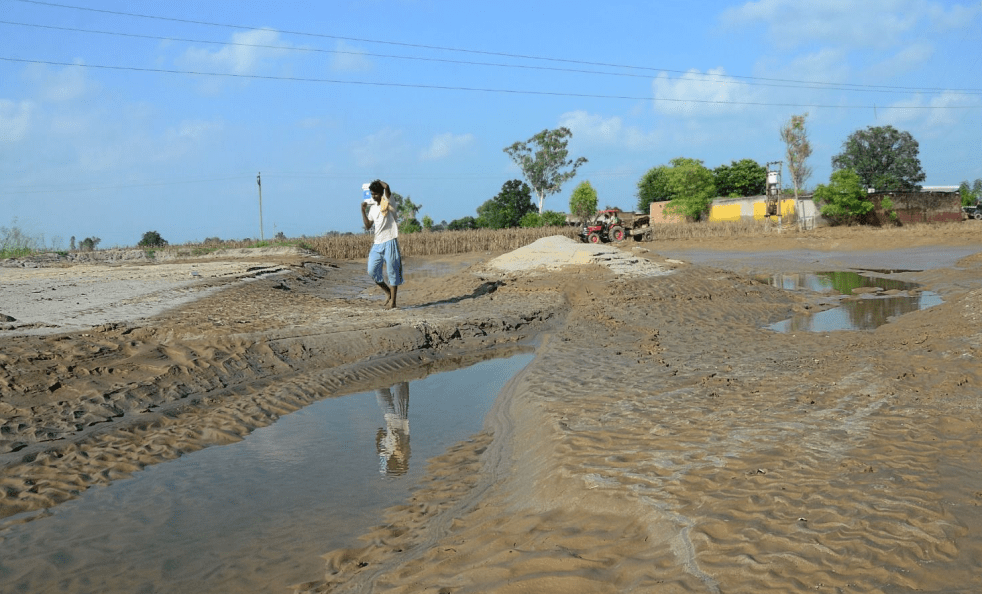
(Feature Image: As the floodwaters recede, silt deposition has been observed in many parts of Mand area in Sultanpur Lodhi, Kapurthala.)
There are a number of stories this week and throughout the ongoing SW monsoon, where the key central figure is the same: Silt. This is true in case of reports about silting of dams, silting of rivers, illegal dumping of silt in rivers and dams, accumulated silt choking Punjab and Delhi rivers, and even a suggestion that what Indus Basin needs is silt management policy.
The silt is an integral part of the flow of any river. The fertile river valleys like that of the Ganges and others have been created by depositing the silt over the centuries by the rivers. But our unsustainable, thoughtless interventions in Himalayan as well as other river basins have converted what is apparent boon in nature to a bane, a curse. Most of the floods we saw this year and in recent years have been made deadlier when the silt and debris flows with the water.
While a National Silt Policy is necessary as a first step, by itself it won’s suffice. We also need an action plan to ensure that minimum amount of silt enter the rivers and reservoirs, since once they enter the rivers and large reservoirs, it is not economically viable to desilt them. To achieve this broad objective of minimising entry of silt in rivers or in other words, stopping and reversing the degradation of catchments of rivers and reservoirs, we will not only need a well thought out action plan & its urgent implementation, but also credible monitoring and compliance. Unfortunately, we have neither good track record nor the will to achieve any of these. Maybe we can start by creating pilots in this direction as soon as possible, as a first step.
Stopping and reversing the degradation of catchments of rivers around the country has many advantages, including improving local and river basin scale water security, reducing disasters, reducing reservoir siltation, reducing river silt accumulation, reducing disastrous floods, improving biodiversity, improving resilience to climate change impacts, improving agriculture production, among others. All these are also part of the prudent silt management, if only we were ready to wake up!
Silting in Karnataka Dams A recent analysis by the Karnataka Water Resources Department revealed that the state’s top ten dams have silted up by 4% to 28%, with average 12.49%. In terms of quantity, Tungabhadra dam in Vijaynagar district received 0.42 TMC silt annually and has accumulated 31.61 TMC silt in 75 years since it was commissioned in 1950. The Basavasagar (Narayanpur) dam in Yadgir district, commissioned in 1982, has the highest siltation in terms of %, at 28%, it has 10.55 TMC silt, second highest in the state.
The TB dam is 21 km long north to south, it its silt was removed and spread to the height of 10 feet in farm land, it will need 73462 acres of land. Even with 1000 tractors removing 1 TMC silt, the task is unviable. In 2017, farmer groups tried to desilt using 125 tractors for two weeks and they could remove only 0.75 TMC silt at an expense of Rs 15 lakhs on diesel and food. The silt was dumped in 10 km radius in Vijayanagar and Koppal districts. The state govt proposed to centre removal of 26 TMC silt at cost of Rs 13695 Cr, but no approval has come.
Currently, active desilting is happening only in case of Harangi dam in Cauvery basin, where 0.031 TMC of silt out of 1.23 silt in the dam is being removed from the confluence point in the backwaters at a cost of Rs 39 Cr.
How climate change, dams & silt are choking Punjab’s rivers Decades of silting have also drastically reduced the storage capacity of headworks and dams. For example, the Ferozepur Headworks, which was built in 1928, had a water storage capacity of 24,000 acre feet (one acre-foot is water with one foot depth on one acre). Today, it has been reduced to only about 5,000 acre feet.
The Harike Headworks’ water storage capacity is down from 67,900 acre feet to about 10,000 acre feet. The Bhakra Dam (1956) on the Sutlej, Pong Dam (1972) on the Beas and Ranjit Sagar Dam on the Ravi (1999) were designed with the water storage capacity of 9.34, 8.57 and 3.28 bn cubic metres, respectively. Their storage capacity is down by 20%.
During heavy rains, excess water from dams is released into rivers to avoid risk of dam failure, which can cause unimaginable devastation. For example, during the 1988 floods, 4.78 lakh cusecs of water passed through the Ropar Headworks on September 26, which increased to 5.74 lakh cusecs by the time it passed through the Harike Headworks on September 28 and the same swelled to 7 lakh cusecs at the Ferozepur Headworks on September 29. Similarly, 4 lakh cusecs of water passed through the Ropar Headworks in 1993.
Today, the condition is such that even moderate releases of 1.5 lakh cusecs in the Sutlej and Beas cause devastation, compared to past floods when much higher flows were absorbed. Interestingly, an Indus Valley civilisation study shows that over 5,000 years, the Ravi has risen about 50 ft above the original level of Mohenjodaro due to continuous silt deposition.
There is a protocol for filling the dams, releasing water for irrigation and power needs and controlling water during floods. But it is of the pre-global warming era. Its re-evaluation is needed — as was done after the 1988 floods, when the full filling date of the Bhakra dam was extended beyond September 15 to accommodate the sudden flow of water. (Kahan Singh Pannu is ex-Secretary, WRD, Punjab).
Despite HC orders, NHAI, Railways continue illegal dumping In a brazen violation of the Himachal Pradesh high court orders, the National Highway Authority of India (NHAI) and the Railways continue to dump landslide debris and muck illegally in the rivers and rivulets along the Kiratpur-Manali highway, including in the Bhakra dam reservoir and the Beas river. The Fourlane Visthapit and Prabhavit Samiti (FVPS) has complained to the Bilaspur deputy commissioner and the forest department with proof about the illegal dumping in the Bhakra dam.
As per the FVPS complaint, the ongoing work on the Bhanupali-Bilaspur-Beri rail line has also been causing pollution in the Bhakra dam reservoir. Along the highway at Bharari, a cofferdam, a temporary structure built by the Railways on the bank of the Bhakra reservoir to create a dry work area, along with huge amounts of debris, has submerged into the lake due to rising water levels. The cofferdam was built for the construction of bridges that would connect Railways tunnel No. 16 Portal-1 with tunnel No. 15 Portal-2. “The Railways dumped muck in the cofferdam to make the wetland dry for building bridges. However, as the water level increased due to heavy rainfall, all the muck submerged in the river along with the cofferdam,” said FVPS.
Landslide debris is also being dumped in the Beas river and rivulets along the highway between Pandoh and Aut in Mandi district. This highway stretch has seen more than three dozen landslides this monsoon. It may be mentioned that in a series of orders, the Himachal Pradesh high court last year lashed out at the NHAI and the state govt departments for failing to stop illegal muck-dumping in the Bhakra dam reservoir and forest areas.
The high court not only ordered the NHAI and the state govt to ensure that muck was not dumped illegally into the rivers and forest areas but also ordered the Himachal Pradesh Pollution Control Board and the govt agencies to lift the illegally dumped muck in Bilaspur district. Following the court orders, the Bilaspur police last year registered eight FIRs against companies hired by the NHAI for the Kiarapur-Manali highway widening work. However, despite the high court orders and police cases, illegal muck-dumping continues unabated.
HYDRO POWER PROJECTS
SC to pronounce order on HP Suo moto case on Sept 23 The Supreme Court on Sept 15 said it will pass an order on September 23 on a suo motu PIL on issues relating to ecological and environmental conditions prevailing in Himachal Pradesh following SC’s observations on July 28 that HP may disappear from the map of India. In an affidavit on Aug 25, HP had sought at least six months to come up with road map.
“List on Sept 23 for order. We will give you a brief order after summarising everything so that you can get specific instructions,” a Bench of Justice Vikram Nath and Justice Sandeep Mehta told Himachal Pradesh Advocate General Anup Rattan and Additional Advocate General Vaibhav Srivastava. The Bench indicated that it intended to expand the scope and ambit of the PIL to the entire Himalayan region. “This is not going to be limited to Himachal only…The entire Himalayan region…,” Justice Mehta said.
‘In principle’ nod for Sawalkot HEP Acting on the urgency to speed up projects of strategic significance, an environment ministry panel has given “in-principle” approval for diversion of over 847 hectares of reserved forest and ‘jungle-jhari’ land for construction of the ambitious 1,856-MW Sawalkot hydroelectric project in Ramban district of Jammu & Kashmir. Certain key green provisions were set aside for the purpose, keeping in view national interests. Though the final approval will be subject to grant of environment clearance for the project by the UT govt, the move shows the intent to swiftly take up the dam’s construction for leveraging Chenab river’s potential following suspension of the Indus Waters Treaty (IWT).
Minutes of the environment ministry’s forest advisory committee meeting, made public this week, show that while giving its approval on June 24, it took note of the Union home ministry’s June 12 plea arguing that conducting cumulative impact assessment (CIA) and carrying capacity studies (CCS) on the Chenab before giving clearance at this juncture “may risk exposure of sensitive hydrological data, which could be exploited by the downstream neighbouring country”.
A day before the home ministry’s note to the advisory committee, the power ministry too on June 11 sought granting exemption from CIA and CCS for the Sawalkot HEP for facilitating its expeditious implementation. It argued how conducting CIA and CCS – prerequisite for grant of ‘in-principle’ approval – may leak sensitive hydrological and environmental data, thereby compromising national interests.
Nangal Hydel Canal, Bhakra Main Canal damaged The 64 km long Nangal Hydel Canal (it runs from Nangal to Ropar, after which it joins the Bhakra Main canal) of Bhakra Project is damaged at 13 places and BBMB has asked the permission from party states to close it for repair. The repair would take at least 25 days. It is in operation for 71 years and has never been closed so far. Bhakra Main Canal is in worse state and also needs repair. If the Nangal Hydel Canal or BML is shut down, it would disrupt the Bhakra water supply to Haryana and Rajasthan.
Residents oppose Sharavathi PSP at public hearing The residents of Sagar taluk, environmentalists, and politicians opposed the Sharavathi Pumped Storage Project at the environmental public hearing conducted by the Karnataka Power Corporation Limited (KPCL) under the chairmanship of Deputy Commissioner Gurudatta Hegade on Sept. 16. They urged Mr. Hegade to recommend to the Ministry of Environment and Forests against the project.
The participants took objection to holding the hearing without sharing the contents of the detailed project report (DPR) with them and not publishing the Environmental Impact Assessment (EIA) report in Kannada. Several local people and environmentalists demanded that the hearing be cancelled even as it began, saying that the public had not been given access to the DPR. The officers of the KPCL and the Deputy Commissioner attempted to convince the public. Further, many people, already affected by the previous dam projects, stated that they had lost hope in the government and KPCL.
Nearly 1,000 people attended the meeting, including politicians and environmentalists. Environment activists Joseph Hoover, Akhilesh Chipli, and Anant Hegde Ashisara argued against the project, mainly demanding a DPR. Deputy Commissioner Gurudatta Hegde, however, refused to put off the hearing and said the Kannada copies of the DPR would be provided soon. Expressing opposition to the project, Kargal town panchayat former vice-president Siddaraju said even slight damage to the Western Ghats region would not only affect the Sharavathi valley but also the flora and fauna in the States that come under the Western Ghats region. The next public hearing is scheduled for Sept 18 at Gerusoppa in Uttara Kannada. Villagers and environmentalists who participated in the hearing expressed strong views about the harm that the proposed project would cause to the Western Ghats.
DAMS
Mah to move SC if Karnataka raises Almatti Dam height Maharashtra chief minister Devendra Fadnavis on Sept 17 said the state government will move the Supreme Court if Karnataka proceeds with its plan to raise the height of the Almatti Dam. This comes after Karnataka cabinet on Sept 16 decided to proceed with the work of raising the dam’s height as part of the Upper Krishna Project-III from 519 to 524 m, increasing dam storage capacity by almost 100 TMC. Maharashtra’s primary concern is that increasing the dam’s height could lead to flooding in border districts such as Sangli and Kolhapur, which lie upstream of the Almatti reservoir.
EAC Sept 26 meeting agenda:1. Shirawta Open Loop Pumped Storage Project (1800 MW) in 197.797 ha at Village Khandshi, Rakaswadi, Thoran etc, Sub-dist Mawal, Dist Pune, Mah by The Tata Power Company Limited – Environmental Clearance
2. Sawalkote Hydro Electric Project (1856 MW) on river Chenab in 1401.35 Ha at Village Bhajmasta, Sub-dist Ramban, Dist Ramban, Jammu & Kashmir by NHPC Ltd- Environmental Clearance
DAM FLOODS
Doyang Dam releases floods Golaghat villages Heavy rainfall in neighbouring Nagaland and the release of water from NEEPCO’s Doyang hydroelectric project have led to severe flooding across Golaghat district in Assam, affecting thousands of residents and prompting large-scale rescue operations. The Dhansiri and Dayang rivers, along with their tributaries, have risen to dangerous levels due to continuous downpour in Nagaland and the discharge of water from Doyang HEP.
Several locals alleged that they received no prior warning about the sudden release of water from the Doyang project. “The water rose suddenly into our homes and fields, destroying our machines and livelihoods. Earlier, authorities used to give us warnings, but this time nothing was communicated,” said one resident of Sonalipathar No. 4. Others echoed similar grievances. “Around 3:30 am, the water started rising rapidly. We had little time to save our belongings, livestock, and machines. This is all because of the water released by NEEPCO. We hope the administration provides us with proper relief soon,” another resident added.
DVC authorities take precautionary advance action to release water from Tilaiya Dam Due to incessant downpours and forecasts of heavy rainfall in the coming days, the Damodar Valley Corporation (DVC) at 8 pm late on Sept 15 evening opened the 4 of 14 gates of Tilaiya Dam as a precautionary measure to release 1100 cusecs water. S M Qadri, in-charge of the Tilaiya Dam Hydel Project, informed that the danger mark of the dam is 1,218 feet, while the current water level stands at 1,214.79 feet. “Though the danger level has not yet been breached, precautionary measures have been undertaken in anticipation of heavy inflows,” he said. “As per guidelines, flood warnings are issued when releases exceed 1,000 cusecs. Normally, 630 cusecs are discharged when both hydel units are in operation,” he said.
PAC questions role of dams in Punjab Floods On September 8, a Ludhiana-based environmental group, the Public Action Committee, released month-long water discharge data from three major dams – Bhakra, Pong and Ranjit Sagar. The Public Action Committee has alleged that dam authorities did not release water gradually. The process of a sudden discharge, combined with Punjab’s own torrential rainfall, culminated in the disaster – one that, PAC members said, could have been mitigated with timely action.
The PAC also alleged that advance warnings were missed when releasing water from the dams. Water discharge data, they also alleged, showed that rainfall prediction issued by the Indian Meteorological Department as early as June was paid not much heed to. Economist R.S. Ghuman said that better management of water discharge from these dams could have mitigated the impact of the Punjab floods, which he said was largely caused by torrential rainfall in the region.
Flooding in Punjab began on August 25. Using this as a reference point, data from the Bhakra dam on the Sutlej river, as quoted in PAC report, shows that between August 1 and 24, the per-day average inflow was 57,430 cusec, while the average outflow was 27,100 cusec. Over the next 11 days, from August 25 to September 4, continuous rainfall in the catchment raised the average inflow by 30% to 73,400 cusec. In contrast, the average outflow nearly doubled to 53,000 cusec, peaking at 73,000 cusecs on September 4.
The situation was even more critical at Pong Dam on the Beas river where water inflow was more aggressive, the PAC finds. Between August 1 and 24, the average per day inflow was 77,000 cusec, against an outflow of 42,500 cusecs. From August 25 to September 4, the average inflow surged by 57% to 1,21,600 cusecs, while the average outflow rose 107% to around 87,500 cusecs, peaking at 1.09 lakh cusec on September 1. Both these dams are managed by Bhakra Beas Management Board (BBMB) in which Punjab is a member states along with Himachal, Haryana and Rajasthan.
The situation was no different with the Ranjit Sagar Dam, which is directly under the Punjab government’s control. The per day average inflow of Ranjit Sagar dam between August 1 and August 24 was 38,700 cusec against average outflow of 11,273 cusec, he said. Over 11 days between August 25 to September 4, it is not just the inflow that surged to 71,960 cusec, but the average outflow surged to 62,800 cusec, he added.
Punjab Engr recommends steps to tackle floods, misses some key issues This article by Shri SK Saluja, Ex Chief Engr of Ranjit Sagar and Shahpur Kandi Dams lists some good suggestions but fails to mention about rule curves to be updated, to be followed, rule curves and all flood and dams related information in public domain, fixing accountability, preparing flood management reports for each dam after each monsoon, prioritising power generation in monsoon.
DAM SAFETY
Is age catching up with India’s dams? Today, India faces the challenge of large parts of its hydrological infrastructure ageing en masse. According to the National Register of Large (Specified) Dams, some 1,065 were 50-100 years old and 224 were more than a century old in 2023. Many major dams of the post-1950 period are now in the last stages of their originally intended lifespan.
Tamil Nadu govt to restore 5 dams at 510cr At least five dams in Tamil Nadu will undergo a major renovation at a cost of 510 crore under the Union govt’s dam rehabilitation and improvement project (DRIP). The dams — Sathanur, Kelavarapalli, Bhavani Sagar, Sholayar, and Upper Nirar — will be renovated to address leakages, replace shutters, strengthen side walls, and restore catchment areas.
WRD engineer-and-chief S Gopalakrishnan said they have another five dams proposed under the DRIP Phase-II scheme, but with the current funding, the govt has decided to start with these five. To execute the project, TN govt has constituted an empowered committee headed by chief secretary N Muruganandam. According to a GO issued by the water resources dept on Sept 4, the panel will bring together senior officials from various depts, along with chief engineers for dam safety, to oversee key projects across the state.
The committee will inspect the five dams, assess the works that need to be undertaken, and the works will begin within a month, said Gopalakrishnan. He added that works for DRIP Phase-III are also underway. “For DRIP-III, we only have 66 crore funding from the World Bank. So, for the third phase, the state govt will fund the restoration of more dams with 2,000 crore funding,” he said.
FLOODS 2025
Webinar on What is behind the recent display of Nature’s fury in North India? Friday 26 Sept. 2025 at 02:00 pm. Registration Link: https://www.cseindia.org/webinar-deluge-disaster-12871
Sukhna Lake floodgate opened for record 11th time this monsoon The UT Administration took measures to manage the rising water level of Sukhna Lake following rainfall in the catchment area, opening one of the three floodgates in the early hours of today for a record 11th time this monsoon season. The excess water was released into the Ghaggar river through the Sukhna Choe as the lake’s water level crossed the danger mark of 1,163 feet.
Ddata shows floodgates were opened four times in 2023, six times in 2022 and five times in 2021. Notably, the opening of two floodgates in August 2020 led to widespread flooding in Zirakpur’s low-lying areas alongside the Sukhna Choe. On September 24, 2018, floodgates were opened after a gap of 10 years.
HFL BREACH
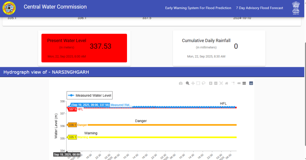
Madhya Pradesh: River Sonar at Narsinghgarh site in Damoh district has crossed its HFL 337.50 meter dated 10.10.2024 at 06:00 hour on 18.09.2025.
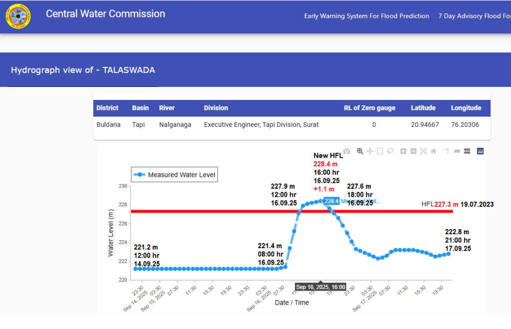
Maharashtra: River Nalganga at Talaswada site in Buldhana district has crossed its HFL 227.3 meter dated 19.07.2023 at 12:00 hour on 16.09.2025 and set new HFL 228.4 meter at 16:00 hour which is 1.1 meter higher than the old HFL. The flood level in the river increased by 7 meters in 08:00 hour from 221.4 meter at 08:00 hour to 228.4 meter at 16:00 hour.
MONSOON 2025
Bundelkhand’s heavy rains push small farmers to the edge The The people of Bundelkhand are in a crisis. This year’s long and heavy monsoon rains have destroyed crops across the region, but it’s the most vulnerable farmers who have been hit the hardest. These small and marginal farmers, many of them women and members of the Sahariya tribal community, are now facing the grim reality of lost harvests, lost livelihoods, and an uncertain future. The author recently visited a small hamlet in the Babina block of Jhansi district, spoke with a dozen small farmers. (By Bharat Dogara)
RIVERS AS NATIONAL WATERWAYS
Dredging on Ganga’s Varanasi-Ghazipur stretch to begin on Oct 1 Dredging work in the Ganga River between Varanasi and Ghazipur, extending up to Majhauva in Bihar, is scheduled to begin on October 1 to ensure the smooth and safe movement of vessels along National Waterway-1 (NW-1). The project aims to create a 30-metre wide and 2.5-metre deep navigable channel by removing hard strata, mainly composed of calcareous siltstone, which currently hinder vessel movement, especially during the lean season when water levels drop significantly. According to a senior official from the Inland Waterways Authority of India (IWAI), two companies have been awarded the dredging contract, and the work is expected to be completed over the next three years.
URBAN RIVERS
Doon residents voice concerns over elevated corridor project A week after Dehradun was ravaged by floods, killing 29 and leaving eight missing, Uttarakhand’s capital city on Sept. 22 saw a rally against the Rispana-Bindal Elevated Corridor Project. The plan for the project has raised concerns that the flow channels could push floodwaters onto banks, and that aquifers could be jeopardised if embankments, pillars, and floodwalls are built along the rivers.v
The Rs 6,200-crore project envisions two roads over the Rispana and Bindal rivers, central to the city. The 14.8-km road over Bindal Road will connect Near Kargi Chowk to Sai Mandir on the way to Mussoorie, and the 10.9-km road over the Rispana river will start from the Assembly to Nagal bridge. The Social Impact Assessment for these are underway. Government data showed that the project puts 2,619 structures at risk of displacement from the land to be acquired.
Musi riverfront protects neither the river nor its people
RIVERS
How the death of the dinosaurs reengineered Earth -Dinosaurs had such an immense impact on Earth that their sudden extinction led to wide-scale changes in landscapes—including the shape of rivers—and these changes are reflected in the geologic record, according to a University of Michigan study.
-Scientists have long recognized the stark difference in rock formations from just before dinosaurs went extinct to just after, but chalked it up to sea level rise, coincidence, or other abiotic reasons. But U-M paleontologist Luke Weaver shows that once dinosaurs were extinguished, forests were allowed to flourish, which had a strong impact on rivers.
-Weaver and colleagues examined locations throughout the western United States that depicted sudden geologic changes that occurred at the boundary between the age of dinosaurs and the age of mammals.
-Studying these rock layers, Weaver and colleagues suggest that dinosaurs were likely enormous “ecosystem engineers,” knocking down much of the available vegetation and keeping land between trees open and weedy. The result was rivers that spilled openly, without wide meanders, across landscapes. Once the dinosaurs perished, forests were allowed to flourish, helping stabilize sediment and corralling water into rivers with broad meanders.
-Their results, published in the journal Communications Earth & Environment, demonstrate how rapidly the Earth can change in response to catastrophic events.
Telangana: Nalla Cheruvu turns red as pharma firm releases effluents Heavy rains are allegedly being exploited by pharmaceutical and chemical companies in Sangareddy to discharge untreated effluents into local water bodies. In Bonthapally and Isnapur, tanks turned red and contaminated water flowed into paddy fields, causing health issues and panic among farmers.
SC takes note of industrial pollution in Jajori river in Rajasthan The Supreme Court on Sept 16 took suo motu cognisance of discharge of industrial waste in Jojari river in Rajasthan. A division bench of Justices Vikram Nath and Sandeep Mehta has directed the court registry to register a PIL on the issue. “This court is taking suo motu cognisance with respect to river Marudhara Jojari, where a lot of industrial waste is being discharged, making water for humans and animals in hundreds of villages unfit,” the apex court said.
-While the case is still at an early stage, the Supreme Court may consider issuing directions such as: Strict enforcement of “polluter pays” principle on industries discharging untreated waste. Independent monitoring of CETPs and industrial units by a court-appointed committee.
-Compensation and rehabilitation measures for affected villagers under the Public Liability Insurance Act or through state schemes.
Directions to the Rajasthan government and Pollution Control Board for a time-bound action plan to restore the Jojari river.
Guidelines for long-term prevention of industrial water pollution in Rajasthan.
YAMUNA Delhi Floodplain: Will DDA Review Riverfront Projects or Continue Ad-hoc Experiments? The decision makers and planners especially LG, DDA, NMCG and Delhi government need to take a timely call whether they wish to continue in non-transparent, non-participatory, unaccountable way and in the manner of ad-hoc experiments with precious Yamuna floodplain at the cost of its eco-system services, future benefits and public money or in the wake of ground realties, they contemplate to correct and reverse the course and prioritize actual restoration of floodplain over detrimental beautification and riverfront projects which are only aiming at privatizing and exploitation the natural resource for commercial interests.
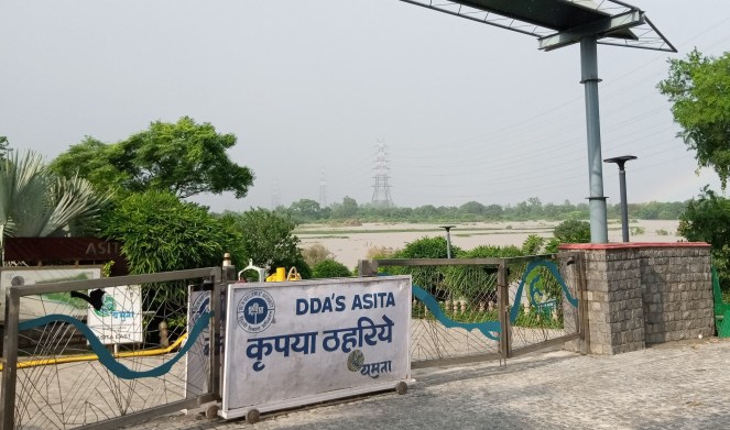
Yamuna Photo Blog Sept 2025: ‘Riverfront’ Projects submerged Again Through pictures and satellite imagery, this blog documents the impact of Sept. 2025 Yamuna flood on Delhi Development Authority’s (DDA) riverfront projects. These 10 projects are being developed over the past 8 years in river floodplain and had also suffered damages during July 2023 floods. Earlier they were called part of floodplain rejuvenation but now being termed as Yamuna riverfront projects. DDA website has only shown name, size and location of riverfront projects, however has maintained secrecy on important factors of cost, progress, delays, damage and losses concerning these projects.
Demarcation of floodplain to start on Sept 15: Govt to NGT The floodplain demarcation will be done following the one-in-100-year rule. According to this policy — using which the Ganga’s floodplain is also demarcated — the authorities will have to mark out the point up to which the river had expanded the most in the last 100 years. In addition to this, a 1-metre contour, or buffer strip, will have to be marked out. This entire area will have to be left free and will be designated the Yamuna floodplain.
In Aug, the tribunal had said that the govt’s last affidavit had not addressed contour space. The NGT bench, headed by Justice Prakash Shrivastava, had remarked that while the affidavit had given details of the outermost boundary, it had omitted the necessary 1-metre contour. In its reply, Delhi govt said that on-ground demarcation would begin on Sept 1. This is the task that has now been pushed to Sept 15. Delhi Development Authority (DDA) has said that tenders for the demarcation were floated on Sept 1.
Govt to seek NGT nod for dredging to curb flooding The Delhi government is preparing to approach the NGT seeking permission to dredge the Yamuna, a move aimed at addressing chronic urban flooding and boosting the river’s diminished water-carrying capacity.
The urgency behind Delhi’s proposal stems from this year’s severe flooding, which pushed water levels beyond capacity and triggered backflow into the city’s drainage channels. Several residential colonies near the floodplain experienced extensive waterlogging, with experts attributing the crisis to the Yamuna’s reduced depth caused by unchecked siltation and untreated sewage inflows.
Ghats, parks shut due to floods As the Yamuna swelled to its highest levels since the devastating 2023 floods, ghats, parks and public spaces along its banks began shutting down on Wednesday. The rising waters inundated Delhi’s largest crematorium at Nigambodh Ghat and submerged manicured spaces such as Vasudev Ghat, Kalindi Aviral, Baansera Park and Amrut Biodiversity Park.
Govt to procure 2 amphibious excavators The procurement is part of a multi-agency effort aimed at rejuvenating the Yamuna River, which remains one of the country’s most polluted rivers. “The machines will be procured for a period of four years, and the company will have to provide the manpower to operate them. The excavator will be used for desilting work, clearing of unwanted vegetation, and landscaping work. We have floated a tender for procurement,” an official said.
The cost of the project will be ₹8.6 crore, including two years of operation and maintenance, watch and ward staff, fuel and other basic costs, he added. The excavators are specialised floating machines that are designed to operate in water bodies. The Irrigation and Flood Control department, which will execute the project, currently has 77 drains under its purview, totalling around 419 km in length.
As per the government’s plan, the I&FC will also be adding floating skimmers on the Yamuna River and the Najafgarh drain. These devices are used to collect floating debris in a body of water. Floating pontoons will be installed on each of the major drains having an outfall in the river, along with other measures to reduce the waste entering the river.
Assess Yamuna rubber dam’s potential impact on Taj foundation: Centre The Centre has advised the Uttar Pradesh government to scientifically assess the potential impact of the proposed Yamuna rubber dam on the Taj Mahal’s foundation and structural integrity, Lok Sabha was told July 31.
In a written reply to Lok Sabha, Minister of State of Jal Shakti Raj Bhushan Choudhary said Uttar Pradesh’s Irrigation and Water Resources Department has been “advised to conduct a detailed scientific assessment & Hydro geological study of the potential impact of impounding water through the proposed rubber dam on the foundation and structural integrity of the Taj Mahal…” He said the state has also been asked to furnish details of a mechanism to ensure continuous flow in the river “so as to tackle water quality”.
Effluents being released into Yamuna? NGT seeks report from HSPCB The NGT has asked Central Pollution Control Board (CPCB) to step in and verify whether the common effluent treatment plants (CETPs) at Barhi in Sonipat are complying with pollution control standards. NGT has also sought a fresh report from Haryana State Pollution Control Board (HSPCB). Haryana has 13 CETPs, out of which four are in Sonipat.
Making CPCB a respondent, the tribunal directed it to independently collect samples from two CETPs — of 16 and 10 MLD — and submit an analysis one week before the next hearing on Nov 19. Based on an earlier joint committee report, the tribunal in Jan impleaded 113 units found to be violating discharge norms.
SAND MINING
Stoppage of use of heavy machinery for Sand mining leads to rejuvenation of springs in J&K As Cranes & JCBs stopped Riverbed Mining in Sukhnag River in Beerwah from last 10 months after NGTs Intervention, almost 10 Springs have been restored in Kanigund and Sail villages. This success story shows that if we disallow use of machines for mining in rivers we can revive our rivers and streams in another 3 to 4 years.
WETLANDS, LAKES, WATER BODIES
Maharashtra: Only 18 out of 23,000 wetlands get health cards Maharashtra has recorded official health cards for only 18 of its 23,046 major wetlands, leaving the state dangerously behind its peers, environmentalists said quoting official data. Maharashtra’s shortfall stems from an incomplete ground-truthing exercise—the physical verification of wetlands with latitude and longitude coordinates—assigned to the National Centre for Sustainable Coastal Management (NCSCM). Without ground-truthing, wetlands cannot be formally notified for protection. Documentation remains in progress, according to information obtained by NatConnect through a RTI.
According to the latest data on the Union MoEFCC Indian Wetlands portal, Madhya Pradesh leads the nation with 94 wetland health cards, followed by Odisha (77), Bihar and Tamil Nadu (71 each), Uttar Pradesh (58), Delhi NCR (56) and Jharkhand (43). Nationally, the gap is stark: of more than 200,000 wetlands larger than 2.25 hectares identified by ISRO’s National Wetland Inventory Atlas in 2010, only 684 have health cards in the public domain.
The MoEFCC portal shows only 1,309 wetlands listed nationwide, including 91 internationally recognized Ramsar sites, against the NWIA list of over 200,000 major wetlands. “The government announces Ramsar sites with great fanfare but neglects broader wetland conservation,” B N Kumar, the director of the environmental watchdog NatConnect Foundation pointed out.
Kerala: Farmer’s fight to preserve wetlands stalls billionaire’s mall plan UAE-based business magnate M A Yusuff Ali’s efforts to bring his global chain of Lulu shopping malls to his hometown of Thrissur in Kerala have hit a hurdle — a 61-year-old paddy farmer fighting for the preservation of dwindling patches of wetlands in the state. T N Mukundan’s legal battle came to light after Yusuff Ali said at an event last Sunday that his plan to build a shopping mall in Thrissur was yet to materialise after “one party” moved a case against it in the High Court.
J&K Gilsar and Khushalsar Need Sustained Action, Not Stagnation After the handing over of the twin lakes to the J&K Lake Conservation and Management Authority (LCMA), there were expectations of a sustained, science-backed conservation plan. However, more than four months have passed, and little substantial progress is visible on the ground. The deployment of a single watermaster machine, mostly lying defunct, without the critical support of barges and sufficient machinery, has yielded negligible results.
The muck remains piled along the edges, invasive Azolla has resurfaced, and residents now worry that the hard-won gains of the past years are slipping away. The fear is real that if this pace and approach continue, Gilsar and Khushalsar may face the same fate as Brari Nambal — reduced to a memory of what once was, swallowed by neglect and mismanagement.
Chandigarh approves proposal to declare Sukhna wetland as Ramsar site The approval was granted during the fourth meeting of the State Wetland Authority under the chairmanship of Punjab Governor and UT Administrator Gulab Chand Kataria. This will be the first Ramsar site in Chandigarh. The proposal will now be forwarded to the Union Ministry of Environment, Forest and Climate Change for funding under the National Plan for Conservation of Aquatic Ecosystems (NPCA) Scheme.
Jhajjar’s Bua ka Talab whispers 390-yr-old love story Located on the Bahadurgarh road in Jhajjar city, a quiet pond called ‘Bua ka Talab’ is not just a water body, but it is a lasting symbol of a 390-year-old love story between a high class girl named Bua and a poor woodcutter named Hasan. ‘Bua ka Talab’ is now part of Shaheedi Park. In earlier times, the pond used to fill naturally with rainwater. However, over the years, the natural drainage channels have become blocked, so it is now refilled with rainwater.
WATER OPTIONS
Pune-based scientist becomes first Indian to win International Water Prize Pune-based scientist Dr Himanshu Kulkarni became the first from the Indian subcontinent to be awarded the biennial ‘International Water Prize’ instituted since 2009, sponsored by the WaTER Center at the University of Oklahoma, USA. The award is dedicated to the field of water supply and sanitation across emerging areas of the world. While the award for Kulkarni was announced in 2024, he was handed the award at a ceremony held on September 15.
Kulkarni was co-chair of a Working Group of the 12th Plan of the Niti Ayog and contributed to the drafting of the National Aquifer Mapping Program. A founder Trustee and Secretary of ACWADAM (Advanced Center for Water Resources Development and Management), Pune, he is also a Professor of Practice in Rural Management at Shiv Nadar Institute of Eminence Deemed to be University and Visiting Professor at the Ashank Desai Centre for Policy Studies at the Indian Institute for Technology Bombay and Tata Institute for Social Sciences.
URBAN LAKES, WETLANDS
Bengaluru is trying to save its vanishing lakes City authorities and volunteers have cleaned and restored dozens of lakes in recent years, but much work remains. Bengaluru had more than 250 lakes in the 1970s. Today, roughly 180 remain and many are in a poor state. Water experts said the city’s explosive growth and mismanagement of sewage have severely damaged a centuries-old network of cascading lakes that sustained communities in this otherwise dry plateau.
Gurgaon waterbody turns a dumpsite: Plea in NGT Over two years after a petition alleged that a three-acre waterbody in Sector 47 was reduced to a “waste dump and mosquito-breeding ground”, NGT on Sept. 17 directed Haryana authorities to spell out the extent of encroachments and submit a detailed report on its condition. Granting them four weeks, the tribunal asked Haryana Shehri Vikas Pradhikaran (HSVP) and the district administration to file their responses before the next hearing, scheduled for Oct 28.
URBAN WATER
Bengaluru’s waste crisis violates Air, Water Acts, NGT orders The black spots and piled-up garbage at collection and mustering centres, along with the seepage of waste water underground, are not just causing inconvenience to citizens but are also violating people’s constitutional rights. It is also an violation of the Air (Prevention and Control of Pollution) Act of 1981 and the Water (Prevention and Control of Pollution) Act of 1974. Justice Subhash B Adi, Chairman of the National Green Tribunal (NGT) State Level Committee, in his recent report – Present Status Report on Bruhat Bengaluru Mahanagara Palike, submitted to the Tribunal, pointed to grave anomalies in waste management by the city corporation.
CPCB finds contamination in Janakpuri’s water supply Very high bacteria contamination was found in the water being supplied to several houses in southwest Delhi’s Janakpuri, CPCB has submitted on Sept. 14 before National Green Tribunal. CPCB, on NGT’s order, collected water samples from 17 houses in the first week of Sept and nine of them had coliform or bacteria, with some having very high faecal levels.
The residents welfare association of the block approached NGT in March with complaints of impure drinking water. In Aug, Delhi Jal Board informed the tribunal that a pipeline was being laid in the block after residents complained of contaminated drinking water for over five months. DJB said the work began on Aug 4 and would be completed within 60 days. DJB had claimed that two days after the samples were collected in July, it temporarily fixed the defects in the pipeline on July 22 while a work order for a long-term solution to provide clean water — laying down the 730-metre pipeline — was issued on Aug 1.
No relief for 3 Dwarka societies battling ‘contaminated’ water Residents say they’ve been facing the issue for two weeks now
Leachate from Bandhwari flowing into Aravalis unchecked There’s no mechanism – neither any trenches nor protective lining on collection ponds — at the Bandhwari landfill to dispose of leachate without harming the Aravalis, an inspection ordered by the NGT has found. The report, activists said on Sept. 18, lays bare MCG previous submissions to NGT that all leachate – toxic viscous discharge from solid waste – was being collected daily and sent to a treatment facility.
The inspection, conducted on August 27 by officials of the CPCB and the Union ministry of environment, was ordered after residents filed a petition before NGT alleging that leachate from the landfill was spilling onto village roads for over a year, creating serious health hazards.
JJM/ RURAL WATER SUPPLY
Water shortage sparks protest in Kupwara’s Lalpora The protesters said that if the concerned authorities failed to mitigate their problem, they will intensify their agitation and will take their protest to the district headquarters.
HIMALAYAN DISASTERS
Landslide in Reasi dist in J&K A cloudburst in Jammu and Kashmir’s Reasi district early Sept 15 triggered flash floods, sparking fear and panic among residents in the hilly areas. There was no loss of life. The incident occurred around 3.00 am in Maadi village of Poni tehsil, as per locals. “There was a huge sound like a blast, and within no time our houses were flooded,” a villager said.
Since August 14, cloudbursts, landslides, and flash floods in Kishtwar, Kathua, Reasi, and Ramban districts have killed over 130 people, mostly pilgrims, injured more than 120, and left 33 untraced. A massive cloudburst in Jammu and Kashmir’s Doda district sparked flash floods in Aug 2025, disrupting daily life. Following record rainfall across the region, the death toll from related incidents rose to 41, most of them from a landslide along the Vaishno Devi pilgrimage route.
When Beas Turns Fierce In the picturesque Kullu Valley, the Beas River, once a symbol of serenity, is increasingly becoming a force of destruction — fed by unchecked floods from five major drains: Fozal, Sarvari, Kasol, Hurla, and Mohal. A recent study by the GB Pant National Himalayan Environmental Research Institute, in collaboration with universities in India and the UK, says floods in these drains have surged by 68% since 1990, turning the Beas into a raging torrent every monsoon.
Researchers traced flood patterns all the way back to 1835, using colonial-era diaries from the British Library and modern weather data. The findings are alarming: 128 major floods across Kullu since 1846, with 87% striking during the monsoon months. In June 2025, flash floods in Kasol’s Grahan Nala nearly swept away vehicles. In 2023, over 10,000 tourists had to be rescued when floods shut down the Bhuntar–Manikaran road. The Sarvari drain has repeatedly damaged water supply systems, while Hurla’s floods have destroyed orchards and farmland. Just this August, the Khokhan drain washed away eight vehicles and damaged private lands.
The study urges immediate steps: build embankments along the drains, ban construction and mining near their banks, and resettle vulnerable communities. Without these measures, experts warn, the Beas could trigger disasters not just in Himachal, but downstream in Punjab as well.
IMD’s inability to certify Cloud-Bursts The term is frequently used by the media and the government. But meteorological and disaster management officials use different approaches to define it. While the meteorological department declares a cloudburst to have occurred when a particular weather station records rainfall of more than 100 mm in one hour, disaster management authorities record events as cloudbursts at the discretion of their field staff.
This year reports issued by Himachal Pradesh’s state disaster management authorities note that the state experienced 17 cloudbursts between June and Sept 17. But officials from regional centres of the Indian Meteorological Department in Shimla and Dehradun said that the centres had not recorded a single cloudburst event this monsoon.
“Whenever the term cloudburst pops up, we see a likely shift where the tendency is to just blame it on nature, and that Himalaya is fragile, the phenomenon is inevitable, and we have nothing to do with it,” said Shubhra Sharma, a scientist with the Physics Research Laboratory at the Department of Space in Ahmedabad.
Officials explained that the fact that the meteorological department did not record any cloudbursts this year did not mean that none occurred – rather, it may have failed to do so because it lacked an adequate number of monitoring devices and weather stations. Anand Sharma, former deputy director general of the regional meteorology centre at Dehradun, explained that a cloudburst can be recorded only if a particular site is equipped with a self-recording rain gauge. Such a gauge records rainfall over the hours it occurs.
Currently, however, the departments’ observatories record rainfall over three-hour spells in most places, or over 24-hour periods in smaller stations. “If we were to record for every hour, that would mean we would have to manually ask someone to record it for that hour, which is not possible to do,” said the official from the meteorological department centre in Dehradun. The official at Himachal Pradesh noted, “Such events can happen at any point even in the night, and we cannot put someone at every weather station to record it in case it happens.”
The use of automated weather stations can also help in recording instances of cloudbursts – these devices collect rainfall data every 15 minutes, which can be compiled to arrive at hourly data. As of 2022, Himachal had 22 such stations, while Uttarakhand had 25. But officials from both the states noted that these stations are spread across multiple districts and are separated by large distances, which made it likely that specific occurrences of cloudburst would go undocumented.
An official at the Himachal Pradesh disaster management authority explained that they largely relied on inputs from their field staff – these could range from tehsildaars in the revenue department to panchayat officials. He noted that the authority essentially left it to this field staff to observe situations on the ground and categorise rainfall events. For instance, if staff on the ground observed particularly heavy rainfall during which rainwater entered people’s homes – an unusual occurrence in mountainous regions – they typically term an incident cloudburst. “Whether the event is a cloudburst or not is at the discretion of the field official,” the official said. Anand Sharma noted that if the staff was not using any equipment, their method of recording cloudburst was “absolutely wrong”.
Anand Sharma argued that as a first step towards better monitoring, the government needed to conduct a preliminary study to determine the kind of capacity that is needed. “We need to have an optimum network study to know how many weather stations and recording devices should be there,” he said. “Do we need it every kilometre? Every two kilometres?”
Dave Petley on Dharali Disaster In his blog dated Sept 18 2025, Dr. Dave Petley concludes:
- “The Dharali disaster was caused by rainfall. There is no other credible trigger that explains simultaneous events in two separate, adjacent, catchments.
- Given the rain gauge record, this must have been a highly localised, cloudburst event.
- Harshil was destroyed by a debris flow that probably originated from a rock slope failure in the catchment above the village.
- The first Dharali debris flow was probably triggered by a rainfall triggered shallow landslide in glacial deposits in the upper part of the catchment, which transitioned into a channelised debris flow.
- The subsequent debris flows at Dharali were caused by other erosive events in these glacial tills. The origin is not entirely clear, but there is evidence of at least one further shallow landslide that may have been the origin for one or more events.
“This is a very provisional analysis based on lower resolution (but still brilliant) imagery. These hypotheses need to be explored through fieldwork and/or high resolution imagery.
Finally, it is absolutely inevitable that the fans at Dharali and Harshil will suffer similar events in the future. Neither will be safe for habitation.”
Flawed development model takes the shine off celebrations The savage assault on the hills by constructing poorly-designed roads, ill-conceived dams and other large projects has brought destruction in its wake. (Ramachandra Guha)
CLOUD BURSTS
15 killed, 16 missing in Dehradun At least 15 people have died and 16 are missing after a cloudburst triggered landslides and caused rivers to swell in Dehradun and nearby districts of Uttarakhand early on Sept. 16. In Dehradun, the areas worst-affected by the cloudburst were Maldevta, Sahastradhara, Manjayada, and Karligad.
The damage due to the day’s floods in Dehradun is estimated to run into over Rs 10 crore. Around 13 bridges have been impacted, with the damage estimated to cost Rs 1.5 crore; 12 agricultural fields were damaged, leading to a revenue loss of Rs 2.3 crore; the damage on 21 roads is estimated at Rs 1.2 crore; and embankments worth Rs 1.7 crore were also damaged. Some houses, an anganwadi centre, a panchayat building, a community centre, 13 shops, 8 hotels, and 3 restaurants also suffered damage. The Sahastradhara–Karligad road was damaged at more than nine points due to landslides.
The death of ‘Dehra’ The capital of Uttarakhand, which flooded this week, was once an enchanting, old world paradise; before the demon of development killed it. (Megha Prakash)
12 missing after cloudburst in Chamoli At least 12 people went missing on Sept. 18 morning after heavy rain buried several houses under debris in Nandanagar of Uttarakhand’s Chamoli district, prompting district authorities to launch a search and rescue operation. This comes two days after 23 people died after cloudburst triggered landslides and caused rivers to swell in Dehradun and nearby districts of Uttarakhand.
A cloudburst caused massive destruction, bringing down 6 buildings under heavy debris in Kuntari Lagafali ward of Nagar Panchayat Nandanagar on Sept. 18. A total of 10 people are reported missing in the natural disaster. Five more bodies were found in the rain-ravaged villages of Chamoli district on Sept. 19 as rescue teams dug through debris and waded through sludge in search of the missing. With this, the death toll due to landslides and flooding in the area has climbed to seven.
CLIMATE CHANGE
WMO report highlights increasingly erratic water cycle Press Release dated Sept 18 2025 from the World Meteorological Organisation (WMO) is about the new WMO report “State of Global Water Resources” highlighting that the water cycle has become increasingly erratic and extreme, swinging between deluge and drought. It describes the cascading impacts of too much or too little water on economies and society. Key messages:
- Only one third of river basins had normal conditions in 2024. The rest were either above or below normal – the sixth consecutive year of clear imbalance.
- All glacier regions worldwide report losses due to melt for third straight year
- Report calls for more monitoring and data sharing.
Paper: Synchronous Droughts in Indian Rivers The findings of a paper by IIT Gandhinagar researches Prof Vimal Mishra and Dipesh Singh Chuphal, published in the journal American Geophysical Union (AGU) Advances says “Drought synchronicity has increased across the Indian rivers in the present period (1850-2012) than in the (pre-industrial era) (1200-1849)”. The authors modelled water flow at 45 gauge stations on major rivers across India, including Ganga and Brahmaputra, from 1200 to 2012. Historical data and observations on water flow were used for the analysis.
Identifying major droughts during the study period of 1200-2012 using reconstructed data, the authors found “exceptional” events in 1987, 1721, 2002, 1358, 1566, 1972, and 1694 — most driven by a failure in monsoons and “reduced flow in several rivers in India”. For instance, the 1721-1723 drought affected three-fourths of the country and was recorded the last millennium’s most severe drought during a monsoon. Ganga and the east-flowing Subarnarekha were among the most affected rivers, the team said.
SOUTH ASIA
Indus Treaty Today by Uttam Kumar Sinha on IWT’s 65th anniversary History carries weight, but it cannot be undone. The real test is not whether the treaty was right or wrong in 1960, but whether it still matters today.
- The rivers continue to flow — indifferent to politics. But the challenges confronting the Indus Basin today are unlike any before, rendering the IWT a document of the past.
- Further downstream, in the Lower Indus Basin, rainfall has grown increasingly erratic, with the once-reliable monsoon transforming from agriculture’s trusted ally into an unpredictable threat… The Indus Basin is under extraordinary strain, far beyond the reach of any treaty clause.
- Alongside climate extremes lies a silent crisis — siltation. Reservoirs are choking, storage capacity shrinks each year, canals carry less water, and rising riverbeds make floods fiercer. These are not distant problems; they are unfolding in real time. What the rivers need is not piecemeal dredging after each flood or ad-hoc desiltation when reservoirs clog, but a coherent national strategy on silt management.
- The broader lesson, however, is clear: Siltation is not just a by-product of floods — it is a growing national crisis, one that demands a long-term, coordinated response. Silt must be seen not as waste but as a resource. It can enrich soil, support construction, and aid land reclamation. A national effort to manage silt could reduce floods, expand storage, and make water use far more efficient.
- But today, water has taken on a very different meaning. It is no longer only about engineering rivers; it is about resilience in the face of climate extremes, preparedness for disasters, and the sustainability of fragile ecosystems.
- What truly matters today is not the fine print of a 1960 agreement, but the sharing of transboundary hydrological data and timely flood information. A detailed, rigid treaty is unnecessary; what is needed is a lean, functional framework, even something as simple as a Memorandum of Understanding.
SANDRP
