
There are a number of welcome developments this week related to rainfall. Firstly, forecasters say that the El Nino may start weakening from Feb and may weaken by June 2024 and neutralize thereafter. This can possibly mean good rainfall in SW Monsoon 2024.
Second bit of welcome development is that IMD, on turning 150, has declared that it will set up more doppler radars, rainfall measuring stations and use supercomputers to predict state and district level rainfall, currently it only does at national and four regions.
The study of tehsil level rainfall trends over the last four decades is the third piece of welcome development on rainfall. We need many more studies like this, possibly from IMD itself. More details given below.
The fourth bit of related good news is that the Bruhat Bengaluru Mahanagara Palike has decided to dig 1000 percolation pits in its gardens all over Bengaluru to recharge groundwater. Such groundwater recharge efforts need to be the urgent focus and action all over India at all available open spaces.
Monsoon 2024 Global models hint at normal rain for India with El Niño moderating First available projections of summer weather for India this year (2024) from major global forecasters seem to suggest regionally variable hot conditions and normal to above normal rainfall from February to May as currently strong El Niño conditions moderate. The first two months (June and July) of the ensuing monsoon, too, may witness normal to above-normal rain, with at least one model suggesting this trend may continue into the third month (August) as well. https://www.thehindubusinessline.com/economy/agri-business/summer-outlook-global-models-hint-at-prospects-of-normal-rain-for-india-with-el-ni%C3%B1o-moderating/article67743640.ece (16 Jan. 2024)
EL NINO conditions may start weakening slightly after Feb 2024. However, the conditions are still expected to continue till June, after which we can see ENSO neutral conditions. https://timesofindia.indiatimes.com/india/scorching-summer-in-india-scientists-predict-strong-el-nino/articleshow/107032841.cms (21 Jan. 2024)
IMD More Doppler radars, supercomputers planned for further precision in weather prediction With the IMD turning 150, the Union Govt plans to augment its instrumentation network: No of Doppler Radars in India has increased from 15 to 39 in 2023, 25 will be added in next 2-3 years, 11 of them in Eastern Himalayas. Total No will go upto 86 in next 5 yrs. This could help predict cloudbursts with sufficient lead time, said Union Minister. The Money will come from Mission Prithvi for which Union govt has recently released Rs 4797 Cr.
The no of rainfall monitoring stations has increased from 3955 in 2014 to 6095 in 2023. Upper Air Stations has increased from 43 to 56. The govt is also fund high powered super computing systems that will enable providing state wise and district wise monsoon forecast compared to the forecast currently for four regions. https://www.deccanherald.com/india/imd-turns-150-more-doppler-radars-supercomputers-planned-for-further-precision-in-weather-prediction-2849833 (15 Jan. 2024)
The IMD has launched the National Framework for Climate Services, which will generate climate data to help mitigate the adverse effects of extreme weather on agriculture, health, power, and water services. The framework aims to improve coordination between the IMD and user sectors and address the impact of climate change on various sectors. https://www.hindustantimes.com/india-news/imd-plans-to-generate-data-to-check-impact-of-adverse-climate-events-101705601289537.html (19 Jan. 2024)
BBMP to dig 1,000 percolation pits The Bruhat Bengaluru Mahanagara Palike (BBMP) is aiming to dig at least 1,000 percolation pits across 115 parks in the city within the next monsoons. Each such pit would cost around Rs 40 000 and percolate 1.24 lakh litres of water. The groundwater levels across the city have plummeted owing to the poor monsoons this year and as a result, many of the borewells in the city have dried up. https://www.deccanherald.com/india/karnataka/bengaluru/bbmp-to-dig-at-least-1000-percolation-pits-across-115-parks-2857945 (21 Jan. 2024)
Study Rainfall increased in 55% of tehsils in last 10 years Majority of India is seeing a surge in southwest monsoon rainfall, with 55 per cent of ‘tehsils’ or sub-districts seeing a significant increase of more than 10 per cent in the last decade (2012-2022), according to a new independent study by the Council on Energy, Environment and Water (CEEW) released. This includes tehsils in traditionally drier regions such as Rajasthan, Gujarat, central Maharashtra, and parts of Tamil Nadu.
-Out of these, nearly a quarter of the tehsils are seeing a pronounced rainfall rise of over 30 per cent during the June to September period. The CEEW study, Decoding India’s Changing Monsoon Patterns—which is a first-of-its-kind granular analysis of rainfall in more than 4,500 tehsils across India spanning 40 years (1982-2022)—finds fast-shifting and erratic monsoon patterns in the last decade. This can be attributed to the accelerating rate of climate change.

Moreover, the CEEW study finds that the increased rainfall in these tehsils is frequently coming from short-duration, heavy rainfall, which often leads to flash floods. For instance, 31 per cent of Indian tehsils experienced an increase of four or more days of heavy rainfall per year in the last decade (in comparison to the previous 30 years) during the southwest monsoons. https://www.ceew.in/press-releases/changing-monsoon-rainfall-patterns-amid-climate-change-in-india ; https://www.ceew.in/publications/decoding-indias-changing-monsoon-patterns (17 Jan 2024)
Rainfall is increasing in more than half of India’s 4,400-odd tehsils or sub-districts, according to a granular analysis of changes in the Indian monsoon, conducted for the first time at the tehsil level. While 55% of tehsils have seen a rise in rainfall, about 11% of them have experienced decreasing rainfall. More worryingly, this decrease occurred largely during the critical southwest monsoon.
In fact, of the tehsils experiencing lower rainfall, about 68% saw reduced rainfall in all the monsoon months from June to September, while 87% showed a decline during the initial monsoon months of June and July, which are crucial for the sowing phase of kharif crops. Most of these tehsils are in the Indo-Gangetic plains — which contribute to more than half of India’s agricultural production — as well as in northeastern India, and the Indian Himalayan region.
The study — authored by Shravan Prabhu and Vishwas Chitale of the CEEW — analyses high resolution meteorological data of IMD spanning four decades, from 1982 to 2022. India collectively experienced 29 ‘normal’, eight ‘above-normal’, and three ‘below-normal’ monsoon years during that period. https://www.thehindu.com/sci-tech/energy-and-environment/monsoon-rains-rising-in-over-half-of-indias-sub-districts-shows-a-four-decade-study/article67749008.ece (17 Jan. 2024)
Most of this increase was recorded in the traditionally drier regions of Rajasthan, Gujarat, central Maharashtra, and parts of Tamil Nadu. https://www.hindustantimes.com/india-news/majority-of-india-s-tehsils-saw-increase-in-rain-in-201222report-101705519960522.html (18 Jan. 2024)
The study recommended close mapping of the monsoon performance at more localised level based and localised decision-making which is crucial for building resilience against monsoon variability. CEEW also recommended the development of district-level climate action plans incorporating tehsil-level climate risk assessments. It also called for investing in automatic weather stations and community-based recordings to capture rainfall variabilities at a hyper-local level.
The IMD recently launched a mission ‘Panchayat Mausam Seva’ that aims to take weather forecasts to every farmer in every village to mark the 150-years of its formation. https://www.business-standard.com/economy/news/30-districts-saw-high-number-of-rain-deficit-yrs-in-4-decades-ceew-study-124011700214_1.html (17 Jan. 2024)
The monsoon pattern in Bengal is undergoing a drastic change with the northern parts witnessing rain deficit, south districts surplus rainfall and traditionally arid zones like Bankura and Purulia a surge in heavy rainfall days, a study has revealed. This has the potential to severely disrupt farming activities, eventually affecting the region’s long-term economic outlook, it warns. https://timesofindia.indiatimes.com/city/kolkata/drastic-change-seen-in-bengal-monsoon-pattern-may-hit-agri-economy-study/articleshow/106942339.cms (18 Jan. 2024)
HYDRO POWER PROJECTS
Himachal Pradesh 1 of 3 damaged Larji dam unit resumes generation The 42 MW X 3 Larji Hydropower project was damaged in floods on July 9. The first 42 MW unit has resumed power generation on Jan 15 2024. The other two units are expected to start generation in May 2024. https://www.tribuneindia.com/news/himachal/damaged-last-year-larji-dam-unit-resumes-power-generation-582506 (19 Jan. 2024)
Water flow in Sutlej river is lowest in 17 years, leading to reduction in generation from hydropower projects. https://www.tribuneindia.com/news/himachal/water-flow-in-sutlej-low-generation-hit-582224 (18 Jan. 2024) परियोजना से गर्मियों के दिनों में 39 मिलियन यूनिट रोजाना बिजली तैयार होती है, लेकिन वर्तमान में इस विद्युत परियोजना से 6 मिलियन यूनिट से भी कम बिजली रोजाना तैयार हो रही है। वैसे नाथपा झाकड़ी से बिजली तैयार होकर उत्तरी ग्रिड के नौ राज्यों को भेजी जाती है, बिजली की कमी के कारण उत्तरी ग्रिड के राज्यों को भी मांग अनुसार बिजली नहीं मिल रही है। https://www.divyahimachal.com/2024/01/countrys-biggest-underground-project-in-crisis-challenge-to-generate-electricity-without-water-satluj-is-drying-up/ (17 Jan. 2024)
Punjab govt to oppose hydro royalty Punjab is opposing HP move to demand more free power from hydro projects and also hand over the hydro projects to HP after 40 years of operation. Punjab is opposing this for the 42 MW Baggi Power house of BBMB for which tenders are to be opened on Jan 22, the project depends on water of Dehar power house and parts of the civil works have been completed. https://www.tribuneindia.com/news/punjab/state-to-oppose-hp-demand-for-more-power-project-royalty-581267 (15 Jan. 2024)
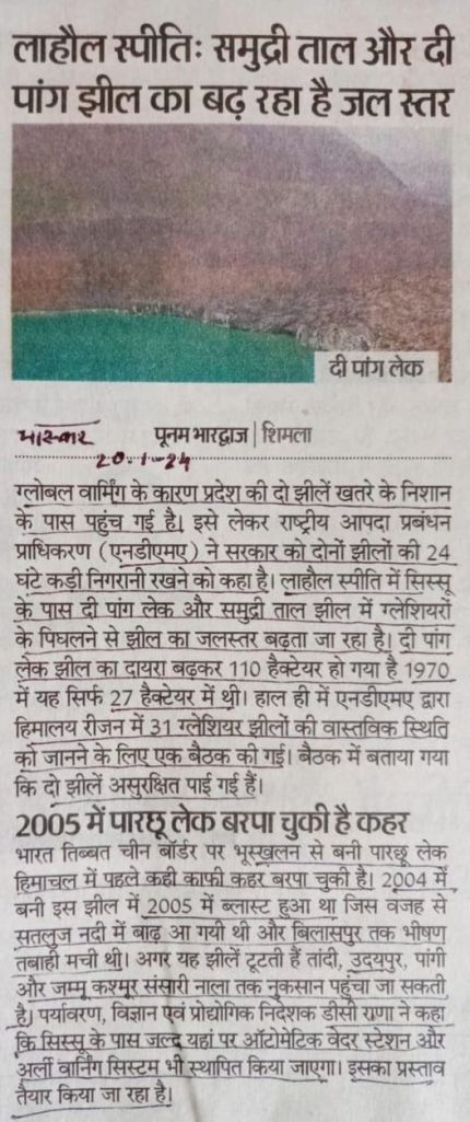
Two glacial lakes near SIssu: The pong and Samudri tal in Lahual Spiti have hugely expanded in area and volume and have been declared as unsafe. There is no early warning system here, there is proposal to put one there. The Pong Lake had an area of 27 ha earlier in 1970 and has now expanded to 110 ha. NDMA has asked for constant monitoring of these lakes. If any of these lakes breach, it can bring vast scale devastation. (Dainik Bhaskar 20 Jan. 2024)
Uttarakhand मुख्यमंत्री पुष्कर सिंह धामी ने नई दिल्ली में केंद्रीय कोयला एवं खान मंत्री श्री प्रल्हाद जोशी से भेंट कर न्यूनतम 1000 मेगावाट के पिट-हेड थर्मल पावर प्लांट स्थापित किये जाने के लिए उत्तराखण्ड राज्य को लगभग 125 मिलियन टन भण्डारण क्षमता की एक कोल ब्लॉक का आवंटन प्राथमिकता पर करने का अनुरोध किया। मुख्यमंत्री ने कहा कि सर्दियों के मौसम में बिजली की कमी गंभीर हो जाती है क्योंकि ठंडे तापमान के कारण नदियों में पानी का बहाव कम हो जाता है। राज्य में बिजली की मांग प्रतिवर्ष लगभग 4 से 5 प्रतिशत की दर से बढ़ रही है और लीन सीजन की अवधि में प्रतिदिन लगभग 4 से 5 मि0यू0 की औसत कमी होती है। औद्यौगिकीरण बढने के कारण आने वाले वर्षों में विद्युत की मांग और बढने की सम्भावना है। https://thehillnews.in/archives/25004 (17 Jan. 2024)
Jammu & Kashmir Prolonged dry spell forces load-shedding extension In an unprecedented turn of events, the prolonged dry spell and snowless winter have dealt a severe blow to power generation capacity, forcing the Kashmir Power Development Corporation Limited (KPDCL) to extend load-shedding periods in Kashmir. “Despite a combined capacity of 3500 MW for power generation in both the Central and J&K sector, the current output has plummeted to a mere 400 MW to 500 MW, occasionally dipping below the alarming threshold of 300 MW,” officials said. This substantial decline has left J&K heavily reliant on external sources to meet its power demands. In response to this dire situation, the KPDCL, confronted with a peak load exceeding 2100 MW, has decided to extend the curtailment period from 2 hours to 2.5 hours. https://www.greaterkashmir.com/gk-top-news/snowless-winter-fallout-prolonged-dry-spell-forces-load-shedding-extension-in-kashmir/ (20 Jan. 2024)
Experts say the snowless winter will have a disastrous impact on the territory’s economy as the tourism sector accounts for about 7% of Jammu and Kashmir’s GDP. It will also impact farming and water supply as scanty snowfall will not replenish groundwater reserves adequately. Environmentalists say that climate change has been impacting the region, causing extreme weather events and prolonged dry spells in both winter and summer. Jammu and Kashmir’s weather department recorded a 79% rainfall deficit in December and a 100% deficit in January. https://www.bbc.com/news/world-asia-india-68015106 (19 Jan. 2024)
Sikkim Submerged Teesta III dam was doomed from start A shoddy consortium, hefty debts and a design that proved to be catastrophic: over 36 years since the Teesta III dam was first proposed, it has come to only spell disaster for the state of Sikkim.
– Teesta Urja Limited changed the dam’s original design that would endanger “the safety of the dam” without seeking prior approvals, a team from the Central Electricity Authority (CEA) had found back in 2008. These observations were noted in the minutes of a meeting of the Expert Appraisal Committee for River Valley and Hydroelectric Projects from 2009: “The Committee observed that a major matter of concern is adoption of a Concrete Face Rockfill Dam (CFRD) with Diversion Tunnels (DT) modified to function as spillway. The altered arrangement of adopting the DTs which can discharge only 3000 cumec is definitely an unsafe proposition for this major 1200 MW power project.”
– It further stated, “The Committee further observed that a rock fill dam with inadequate spillway capacity faces the risk of overtopping, which leads to Dam Break: a catastrophic proposition as five major schemes Teesta IV, V, VI and two low dams are planned/ constructed on the river downstream.” https://www.eastmojo.com/sikkim/2024/01/20/eastmojo-investigation-submerged-sikkim-dam-was-doomed-from-start/ (20 Jan. 2024)
3 HEPs affected in GLOF At least three hydropower projects totaling 2,210 MW have been damaged in the Sikkim flash floods. The worst affected of the three is the 1,200 MW Teesta Stage-III hydro power plant. Along with it, a 200-metre bridge connecting the dam with the power station has also been washed away. NHPC Ltd shut its 510 MW Teesta-V hydel plant due to the flash floods. While the PSU did not mention the extent of damages to the hydel station, senior officials told Money Control it is likely to be “substantial.” The third project – Teesta-VI hydroelectric project (500 MW) was not operational, but is under construction. This project was executed by Lanco Teesta Hydro Power Limited, a wholly-owned subsidiary of NHPC Ltd. https://www.moneycontrol.com/news/business/exclusive-at-least-three-hydropower-projects-of-2210-mw-affected-in-sikkim-flash-floods-11480151.html (05 Oct. 2023)
Meghalaya Umiam dam repair work to finish in six months The ongoing repairs on the Umiam Dam are expected to take up to six 22 people are months to finish, much to the dismay of daily commuters who travel on this crucial route connecting Shillong with the rest of the nation. According to a MeECL official on Monday, repair work is done around-the-clock, seven days a week, with workers taking breaks on Sundays. Around 20 to engaged during a shift. Officials claim that the senior managers of MeECL evaluate the work’s advancement on a daily basis.
Officials did note, though, that the continuous repairs are a highly specialised and scientific task, and they do require time. Various types of drilling are being conducted within the dam, they said. https://theshillongtimes.com/2024/01/16/umiam-dam-repair-work-to-finish-in-six-months/ (16 Jan. 2024)
MoEF 12 Gw PSPs get govt’s EC -According to the minutes of the meeting of the 5th Expert Appraisal Committee (EAC) on River Valley and Hydroelectric Projects in December 2023, Greenko Energy’s proposal for a 3.66 Gw project in Uttar Pradesh’s Sonbhadra district was the largest project to receive an environment clearance recommendation. Two projects with capacities of 1.2 Gw each, belonging to Sterlite Grid and Gandhwani Energy in Chhattisgarh, received recommendations. One project of Oju Subansiri Hydro Power Corporation of 2.22 Gw for Arunachal Pradesh and one project of JSW Energy of 1.5 Gw for Maharashtra were also given the nod. https://www.business-standard.com/amp/industry/news/centre-approves-nearly-12-gw-pumped-storage-hydropower-projects-124011800894_1.html (18 Jan. 2024)
Power Ministry RK Singh vows to double hydropower capacity Delivering the keynote address at Money Control’s Policy Next summit, Union Minister for Power and New and Renewable Energy RK Singh said India’s hydropower capacity will be increased from 47,000 megawatt (MW) to at least 90,000 (MW). The Union minister informed that another 18,000 MW of hydro projects are under construction and 13,000 MW are under various surveys and investigations.
While projects totaling 31,000 MW are under the pipeline, the minister did not give clarity on the remaining 12,000 MW-22,000 MW for doubling India’s hydro capacity. However, senior officials in the power ministry said potential sites have been identified for the remaining quantum. https://www.moneycontrol.com/news/business/mc-exclusive-rk-singh-vows-to-double-indias-hydropower-capacity-12080891.html (19 Jan. 2024)
Defense Ministry Minister red-flags ‘natural disasters’ in border states Defence Minister Rajnath Singh Friday (Jan. 19) termed natural disasters in Himalayan border states — like sudden landslides — a national security issue and sought to increase cooperation with friendly countries to rule out the role of any “adversary” in these, an indirect reference to China, whose territory also extends to the Himalayan region. “Climate change in the country is not just a weather-related phenomenon but the matter is related to national security. The Ministry of Defence (MoD) has taken it very seriously and will seek help from friendly countries to study and rule out any involvement of any of our adversaries on this issue,” he said. https://theprint.in/defence/rajnath-singh-red-flags-natural-disasters-in-border-states-wonders-if-any-adversary-involved/1930656/ (19 Jan. 2023)
DAMS
Kaleshwaram Project Experts moot tech committee before judicial probe Experts have urged the State government to verify technicalities to study in detail flaws in investigation, design and execution, including operation and maintenance, of the Kaleshwaram project before ordering a judicial probe. Even though the area has very deep sand bed (about 60m) no proper studies and precautions were taken up. The Kaleshwaram barrages (three nos) were just diversion structures with a max cap of 16 tmcft. However, having 16 tmcft is also undesirable for a barrage, experts opined. As the capacity is very huge and very deep sand bed of about 60, the concept of design should have been a very detailed one, with design principles same as that for a dam. https://www.thehansindia.com/telangana/experts-moot-tech-committee-before-judicial-probe-into-kaleshwaram-851439 (15 Jan. 2024)
Vigilance probe holds L&T responsible for Medigadda Barrage damage The Vigilance and Enforcement inquiry has fixed the primary responsibility on L&T, the agency that constructed the 1.632 km long Medigadda Barrage as part of Kaleshwaram Project on Godavari River in Telangana structure. Highly-placed sources said that in the field, the inspection conducted at the barrage site with the help of engineering experts for two days has revealed several flaws from the stage of foundation of the structure itself. Further, it was found that there was no proper maintenance of the structure, which is just about four-year old, as the damage was not a development that occurred overnight. Enquiries with the engineers who were part of the execution of the barrage have revealed to the vigilance probe team that some cracks on the damaged piers, although they were small initially, started developing 24-36 months back itself.
– Enquiries with the Irrigation department officials have revealed that no senior official/engineer visited the barrage since completion of its construction in 2019 till the incident of pier displacement occurred on October 21.
– Flaws were noticed in the design, construction of the barrage from foundation stage and quality check/control during and after construction and the next stage of their inquiry would be fix the responsibility on officials/engineers involved in the project execution. “We will also probe the role of the bureaucrats and fix responsibility on them, if they are found to be lacking in acting properly in decision-making,” a probe official asserted. https://www.thehindu.com/news/national/telangana/vigilance-probe-holds-lt-responsible-for-medigadda-barrage-damage/article67760509.ece (20 Jan. 2024)
Madhya Pradesh Rajkumar Sinha on Basania Dam on Narmada River: -बड़े बांधों को बनाने की सरकारी जिद सत्तर के दशक से नर्मदा घाटी में हाहाकार मचा रही है, जबकि उनसे गिनाए गए लाभ आज तक कारगर नहीं हो सके हैं। https:// http://surl.li/pomty (19 Jan. 2023)

INTERLINKING OF RIVERS
Ken Betwa Linking The 5th meeting of Steering Committee meeting held at Khajurao in MP on Jan 18-19 2024. This PIB PR about the meeting is notable to show that none of the senior UP officials were present. There is no mention of how the Forest clearance conditions will be implemented, as it says the power component will have to be outside the forest area. https://pib.gov.in/PressReleasePage.aspx?PRID=1997895 (19 Jan. 2024)
Ken Betwa Project review meeting on Jan 17-19 in Khajuraho to be headed by Secretary, Jal Shakti Ministry. The last date for submitting tenders is Jan 18, they will be opened on Jan 25. There is proposal to include Patne Irrigation Project of Panna as part of the KBP. https://www.bhaskar.com/local/mp/bhopal/news/union-jal-shakti-ministry-meeting-between-17-19-january-modi-can-lay-the-foundation-stone-of-daudhan-dam-in-february-132430479.html (12 Jan. 2023)
INTERSTATE WATER DISPUTES
Cauvery Water Disputes CWRC orders Karnataka to release 998 cusec water daily The Cauvery Water Regulation Committee (CWRC) on Thursday (Jan. 18) ordered Karnataka to release river water to Tamil Nadu in the remaining days of January, and February according to the quantum fixed by the Cauvery Water Dispute Tribunal (CWDT) final order as modified by the Supreme Court. The CWRC headed by its chairman Vineet Gupta held its meeting to review the water and crop situation in the Cauvery basin.
The CWRC on Jan. 18 asked Karnataka to release 1,182 cusec of water per day for remaining days in January and 998 cusec each day for the entire February. In the meeting, Tamil Nadu demanded that Karnataka release 19 tmcft of water, including 7.61 tmcft backlog from January 19, to the end of May, 2024. Expressing its inability to release any more water to Tamil Nadu, Karnataka told the meeting that all four reservoirs in Cauvery basin in Karnataka were facing a cumulative 52% shortfall in storage. The water available in Cauvery basin reservoirs is required to meet the demand of drinking water and irrigation till the start of monsoon in the state, Karnataka argued. https://www.deccanherald.com/india/karnataka/cwrc-orders-karnataka-to-release-998-cusec-water-daily-to-tamil-nadu-in-february-2855248 (19 Jan. 2024)
RIVERS AS NATIONAL WATERWAYS
Uttar Pradesh कोलकाता से अयोध्या जा रहा जलयान सरयू नदी में फंसा सरयू नदी से राष्ट्रीय जल मार्ग का शुभारंभ होने की तैयारी चल रही है। इसके लिए कोलकाता से अयोध्या जलयान चला था, जो कि बलिया के रेवती थाना क्षेत्र में बुधवार (Jan. 17) को फंस गया। जलयान को निकालने के लिए दो क्रूज लगे हुए हैं। जलयान बुधवार की शाम नदी में पानी कम होने की वजह से बालू की रेत में फंसने की बात सामने आई है।
बुधवार को सिकंदरपुर तहसील क्षेत्र से सरयू नदी के रास्ते जलयान को गुरजना था। इसके लिए दरौली स्थित पीपा पुल को हटाने का भी कार्य किया गया था। कोलकाता के सागर आइलैंड से बीते सात जनवरी को रवाना हुए जलयान को हर हाल में 17 जनवरी को खरीद से रवाना हो जाना था। हालांकि मंगलवार (Jan. 16) को मांझी घाट के पास भी नदी में पानी कम होने की वजह से रोकना पड़ गया था। https://navbharattimes.indiatimes.com/state/uttar-pradesh/ballia/kolkata-to-ayodhya-going-ship-stuck-in-saryu-river-near-ballia-two-cruise-lines-rescuing/articleshow/106963916.cms (18 Jan. 2024) https://www.youtube.com/watch?v=64VVDFBBQpM (18 Jan. 2024)
IRRIGATION
Karnataka Live Water storage in Tungabhadra Dam is now 8.151 TMC. Of this, TB board needs to release 2.851 TMC to Andhra Pradesh, Karnataka share is 2.481 TMC. The Irrigation Advisory Committee on Jan 19 2024 has decided to release water for drinking water needs of downstream districts Koppal, Raichur, Vijaynagara and Ballari.
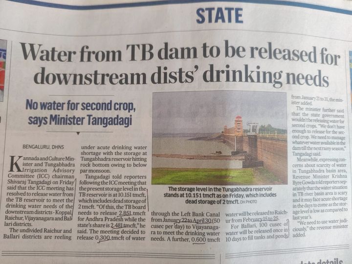
– 0.3 TMC through LBC from Jan 22 to Apr 30 at 50 cusecs to Vijayanagara. Another 0.6 TMC to Raichur from Feb 15 to 25. For Ballari, 100 cusecs after will be released once in 10 days to fill tanks and ponds from Jan 21 to 31. No water to be released for second crop. https://kannada.asianetnews.com/state/tungabhadra-water-to-4-districts-till-the-end-of-june-says-minister-shivaraj-tangadagi-gvd-s7jvix (20 Jan. 2024)
Irrigation projects affect drinking water supply in Andhra Pradesh and Telangana. https://www.deccanchronicle.com/nation/in-other-news/irrigation-projects-affect-drinking-water-supply-in-ap-and-ts-879244 (20 Jan. 2024)
URBAN RIVERS
Maharashtra Rivers in Peril: 38% of sewage untreated With half of population residing in different cities for work, Maharashtra’s rapid urbanization is taking a toll on the rivers. In the 27 Municipal Corporations, a staggering 38% (2497 MLD) of sewage remains untreated, exacerbating the pollution of rivers. Shockingly, only 19% of the 238 municipalities in A, B, and C categories are equipped for sewage treatment, despite generating 874 MLD of wastewater. This means that only 4 % of municipalities in these categories treat their wastewater, compounding the environmental challenges. https://www.punekarnews.in/maharashtras-rivers-in-peril-38-percent-of-sewage-untreated-reveals-mpcb-and-cbcb/ (22 Jan. 2024)
Mula-Mutha; Pune Campaign to create awareness about Rights of Rivers Pune River Revival, a Pune-based citizens group, will conduct a 3-day campaign called ‘Rights of Rivers, My Responsibility’ from 26th-28th January to create awareness about rivers amongst citizens. 26 January is India’s republic day – a day to celebrate India’s constitution. We are one of the few countries in the world where the Constitution acknowledges that clean and safe natural environment is a part of the right to life of the citizens and maintaining the same is also a duty of the citizens. In view of this, Pune River Revival [PRR], an association of 60+ organisations and individuals who have come together for ecological rejuvenation of rivers in Pune, will be launching the Rights of Rivers Campaign for the 7 rivers in namely Mula, Mutha, Ramnadi, Pawana, Indrayani, Bhama and Bhima rivers.
The campaign is for 3 days from 26th January to 28th January 2024. The campaign will be collectively executed by Jeevitnadi, NAPM, Jalbiradari, Jaldindi Pratisthan, Namami Indrayani Pratisthan, Shri Alandi Dham Seva Samiti, Manharsh Foundation, Ranjai, Rotary Club of Walhekarwadi, Nisargsevak, Sajag Nagrik Manch and many more organizations. International River Expert Parineeta Dandekar will inaugurate the campaign on 26th January. https://www.mypunepulse.com/pune-citizens-group-to-conduct-3-day-campaign-to-create-awareness-about-rights-of-rivers-amongst-citizens/ (20 Jan. 2024)
SEIAA defers EC for RFD project The State Environment Impact Assessment Authority (SEIAA) has deferred issuing Environment Clearance (EC) for the River Front Development (RFD) while asking the civic body to complete the compliance with the conditions laid by it. The SEIAA also asked Central Water and Power Research Station (CWPRS) to specifically comment on whether after channelisation of river under the project would there be rise in river flooding events in Pune city.
According to the civic body’s proposal, a total of 7,539 trees will be affected of which 3,110 would be completely cut while 4,329 would be transplanted. The PMC will be planting 66,434 new trees to compensate for the cutting of trees. In its minutes dated November 7 last year and issued on Monday (Jan. 15), the SEIAA observed that the PMC should submit compliance of 18 requirements for getting EC for the project.
-It also asked the CWPRS to analyse the Hyrdaulic and Hydrology study and specifically comment on “whether after channelisation would there be rise in river flooding events in Pune city as well as Pluvial floods beyond both the banks of rivers, whether after channelisation as the confluence of Mula and Mutha river would there be rise in river flooding events, whether 100 years floods data has been considered while computing the flood levels.” https://indianexpress.com/article/cities/pune/eia-defers-green-clearance-for-riverfront-development-project-9110676/ (15 Jan. 2024)
Will RFD reduce floods? This project, claimed by the civic body as a means to “reduce flood levels,” is alleged to involve narrowing the rivers through the dumping of debris, posing a serious flood and environmental threat. Citizens like Sarang Yadwadkar, along with his team, alarmed by the potential ecological impact, approached the SEIAA, an environmental clearance body, successfully halting the PMC’s alleged “killing spree” of rivers and trees. According to Yadwadkar and his team, if the PMC proceeds with the project without any “scientific research to support” it, the ongoing project may pose serious threats. https://www.freepressjournal.in/pune/pune-pmc-questioned-is-river-front-development-genuinely-aimed-at-reducing-floods (16 Jan. 2024)
Debris dumping persists in Bird Sanctuary despite warnings It was 11 a.m. on Thursday (Jan. 18) when three tractors carrying construction debris arrived at the ecologically-sensitive Salim Ali Bird Sanctuary on the banks of the Mula-Mutha river in Kalyani Nagar and one of them started emptying the trash. When Pune Mirror asked the driver for details about the source of the debris, he refused. The two other tractors too emptied the debris. Shockingly, there was nobody from the Pune Municipal Corporation to stop them.

The relentless dumping of debris at the bird sanctuary continues unabated, despite the issue having been raised by activists. Pune Mirror had reported the illegal activities on Dec. 4, 2023, under the headline ‘Ravaging bird sanctuary’. Following the report, the issuing of notice to the responsible operators by the assistant commissioner of Nagar Road (Vadgaon Sheri) regional office of PMC, Rajendra Bankar, had no effect on the dumping of debris by the trucks. The notice was issued after a physical inspection of the ongoing situation by the civic officials. https://punemirror.com/pune/cover-story/pune-environmental-crisis-deepens-as-debris-dumping-persists-in-dr-salim-ali-bird-sanctuary-despite-warnings/cid1705632048.htm (15 Jan. 2024)
Musi; Hyderabad RFD project set to be revived in next 3 yrs At a recent meeting with higher officials of the municipal administration and urban development on January 2, the CM announced that the state government will take up “Musi Riverfront Project” under public-private-partnership mode, without causing financial burden on the state government. In the first phase, the state government proposes to develop the 55-km-stretch of the Musi River in Hyderabad on the lines of Sabarmati RFD of Gujarat and Hooghly RFD of Kolkata.
In June 2017, the previous govt incorporated the Musi Riverfront Development Corporation Limited (MRDCL) to take up rejuvenation, beautification and development of the riverfront at an estimated cost of ₹16,634 crore. The project also included the construction of STPs, three check-dams and 14 new bridges across the river at different parts of Hyderabad. “In the last six years, the government constructed as many as 31 STP in addition to the already existing STPs, on the Musi River,” Kumar said. In August 2005, the then govt launched a “Save Musi” project at a cost of ₹906 crore, seeking to restore the river. https://www.hindustantimes.com/india-news/telangana-musi-riverfront-beautification-project-set-to-be-revived-in-next-3-yrs-101705320080553.html (15 Jan. 2023)
CM began his London visit on Thursday, January 18. He held a three-hour discussions with representatives and specialists from the Port of London Authority, the main organisation that oversees the Thames River. https://www.siasat.com/telangana-cm-discusses-musi-rejuvenation-with-thames-authority-in-london-2959686/ (19 Jan. 2024)
Adyar; Chennai Crores to restore Adyar down drain as sewage flows into river Metrowater spent 123.19 crore in the past 4 years to plug 39 sewage outfalls in Adyar river, construct pumping stations and STPs. But on Friday (Jan. 19), TOI saw a Metrowater line along Thiru Vi Ka bridge leaking sewage into the river. The pipeline carries sewage from Mylapore, Ice House, Teynampet and Adyar to a pumping station on Brodies Castle Road. And this is not the first time it has burst, contaminating the Adyar. The pipeline had leaked sewage into the river in March 2019, Jan 2022, Dec 2023 after Cyclone Michaung and again now.
In January 2022, Metrowater replaced the old concrete sewer with a cast-iron pipe. But on December 6, 2023, the pipeline burst letting untreated sewage into the Adyar. One lane of Thiru Vi Ka bridge was cordoned off then. Anti-corruption NGO Arappor Iyakkam’s convenor Jayaram Venkatesan said the government is the major polluter of rivers. “It shows that the authorities are not serious about the issue,” he said. https://timesofindia.indiatimes.com/city/chennai/crores-to-restore-adyar-down-drain-as-sewage-flows-into-river/articleshow/107002262.cms (20 Jan 2022)
Notice to cattle farm over river pollution-Chennai city corporation recently issued a notice to a cattle farm functioning along the Adyar River bank in RA Puram for allegedly releasing farm waste directly into the waterbody. The action was taken following complaints from students of Dr MGR Janaki College for Women. It may be noted that the city corporation has not been issuing any license to cattle owners over the past two decades, though the rules mandate it. Corporation officials said the practice has slowly fizzled out in the city. https://www.newindianexpress.com/amp/story/cities/chennai/2024/Jan/20/chennai-corporation-issues-notice-to-cattle-farm-after-plaint-over-adyar-pollution (20 Jan. 2024)
N-choe; Chandigarh NGT takes suo motu notice of Express report on N-choe NGT has taken suo motu notice of The Indian Express Dec 15 report, ‘How garbage is choking N-choe in Chandigarh.’ The report highlighted the dire condition of the seasonal stream N-choe running through the heart of Chandigarh. In response to the notice, the Chandigarh Pollution Control Committee (CPCC) submitted a comprehensive reply, acknowledging that sewage water was entering N-choe at two identified points near the roundabout of Attawa village in Sector 42 and the bridge at Sector 23/36 (Sector 36 side) and both these points have been plugged. https://indianexpress.com/article/cities/chandigarh/ngt-express-report-n-choe-pollution-9118396/ (20 Jan. 2024)
CPCC asks admin to install iron nets along N-Choe Acting on the directions of the NGT, the Chandigarh Pollution Control Committee (CPCC) has again asked the UT engineering department to install iron nets along the N-Choe, wherever required, to check the throwing of waste into it. The tribunal had issued a notice to the CPCC on garbage “choking” the N-Choe, a water drainage channel running through the city that eventually joins the Ghaggar river. https://www.hindustantimes.com/cities/chandigarh-news/pollution-panel-asks-chandigarh-administration-to-install-iron-nets-along-nchoe-101705689028295.html (20 Jan. 2024)
Garbage is choking N-choe N-choe – a seasonal stream which ideally should be alive only during rain – is buzzing with floating water not of rain but of blackish sewage. Thanks to the apathy of the Chandigarh Administration as it failed to adhere to the repeated guidelines of NGT that the untreated water should not enter at any cost in any seasonal streams passing through the city and finally immersed into the Ghaggar river. According to the NGT guidelines issued in 2019, the UT administration is to ensure the release of 100 per cent treated water into rivers and drains by March 2020. Although in 2021, NGT had found hardly any significant development. There are at least 6 operational STPs in Chandigarh. Sources said that the issue of sewage water drained in the choe is being raised by a few councillors but no concrete measures have been taken yet. https://indianexpress.com/article/cities/chandigarh/n-choe-stream-monsoon-sewage-water-9069052/ (15 Dec. 2023)
Tawi; Jammu River facing extinction Originating in Kailash Kund, a glacier in Bhaderwah of the Doda District, the Tawi River crosses into Pakistan’s Punjab province and falls into the river Chenab. There was a time when Tawi accentuated the beauty of Jammu, adding to the lore of its temples, but it now only tells a story of desecration and neglect.
– Flowing through the city of Jammu, the river Tawi, also known as Surya Putri, it is believed, was brought here by a local deity—Raja Pehar Devata—who wanted to use its waters to cure his father.
– Environmentalists like Ohri also highlight how the Jammu Smart City Project has focused only on short-term cosmetic development, thereby failing to keep the environment healthy and sustainable. Ohri further believes that initiatives like the Tawi River Front project have endangered the lives of communities by increasing the chances of Tawi’s banks getting flooded: “Such projects have also threatened the existence of communities living on the island of River Tawi, where areas like Beli Charana have already faced catastrophe during the 2014 Jammu floods. At that time, they were cut off from the rest of the city for more than two months.” If anything, the Tawi River makes clear that if we wish to celebrate the country’s sacred geography, we need to protect it first. https://frontline.thehindu.com/news/india-jammu-sacred-tawi-river-facing-extinction-climate-change-environmental-problems/article67751441.ece (18 Jan. 2024)
Doodh Ganga, Srinagar Sewage waste being dumped into Doodh Ganga. https://fb.watch/pD8txErkTI/ (17 Jan. 2023) Dr. Raja Muzaffar Bhar: -Majority of rivers and streams in J&K are snow-fed and emerge from glaciers and if there is no snowfall in the higher reaches it will lead to drought in the summer. Already the drinking water crisis is quite visible. The Doodh Ganga stream has almost dried up due to no snowfall or rainfall during the last almost a month now. The situation has further turned ugly as the depth of Doodh Ganga has gone down drastically in the last few years due to illegal riverbed mining. The Doodh Ganga water filtration plant is receiving very less water from its source at Nowhar in Chadoora upper reaches. https://www.greaterkashmir.com/editorial-page-2/no-snowfall-in-chilaikalan-its-consequences/ (19 Jan. 2024)
RIVERS
UNEP Aim to safeguard freshwater sources UNEP and Rotary International announced their partnership at Rotary International Assembly, which ran from 7-11 January 2024. The initiative will share guidance and information from UNEP’s experts and partners with Rotary members on the best way to protect, restore and sustain freshwater ecosystems. UNEP believes that the key to protecting and sustaining natural ecosystems is engaging, educating and motivating the communities that live close to those ecosystems.
A pilot project, Adopt a River for Sustainable Development, was recently implemented in Rotary District 9212 covering Eritrea, Ethiopia, Kenya and South Sudan. The effort showed that solid waste clean-ups have an immediate impact and are an excellent way to mobilize community action. However, the clean-ups have limited benefits unless the source of the waste is addressed. It is also important that projects engage with communities early in the planning process and work closely with local government agencies that are best able to maximize the impact of available funds, experts say. https://www.unep.org/technical-highlight/unep-rotary-partnership-aims-safeguard-freshwater-sources (17 Jan. 2024)
Manipur Water crisis intensifies amid oil spill from Leimakhong power station The leakage of heavy fuel oil from the Leimakhong power station in the Kangpokpi district has made the water challenges faced by the villagers, especially those residing near the Makha Khong stream at Kanto Sabal in Imphal West district, worse. The leakage occurred on the evening of January 10, leading authorities to divert the Makha Khong stream into a paddy field in Kanto Sabal on the same day. Ten days later, villagers from areas like Khurkhul, who are dependent on the stream, are yet to receive water from the authorities. https://indianexpress.com/article/india/water-crisis-intensifies-manipur-kangpokpi-oil-spill-leimakhong-power-station-9119369/ (21 Jan. 2024)
Kerala Digital mapping identifies 1,271 water sources in Wayanad As many as 1,271 water sources, including rivulets and streams, have been identified in Wayanad district under the two digital mapping campaigns to rejuvenate waterbodies in the district, especially the Kabani river, a major tributary of the Cauvery. The campaigns titled ‘Kabanikkayi Wayanad’ and ‘Surakshithamakkam Paschimakhattom’ were organised by the Haritha Keralam Mission with the support of local bodies and educational institutions.
The campaign aims at ensuring the existence of major water sources and mitigate climate change impacts. When the mapping was completed in the 26 civic bodies in the district, the most water sources were identified in Vellamunda grama panchayat, with 85 water sources, and the lowest in Vengappally, with 26 sources. Those water sources will be conserved with support of the workers under the Mahatma Gandhi National Rural Employment Guarantee Scheme and civic bodies. https://www.thehindu.com/news/national/kerala/digital-mapping-identifies-1271-water-sources-in-wayanad/article67752982.ece (18 Jan. 2024)
Tamil Nadu Govt plans to rid rivers of plastic waste As part of the Rs1,675 crore-worth Tamil Nadu Coastal Restoration Mission for 14 coastal districts, including Chennai, the state environment department plans to clean plastic trash in rivers using interceptors developed by a Netherlands-based organisation called The Ocean Cleanup. https://timesofindia.indiatimes.com/city/chennai/tamil-nadu-plans-to-rid-rivers-of-plastics-waste-using-intercepters-by-netherlands/articleshow/106893000.cms (16 Jan. 2024)
Madhya Pradesh MPCB shuts 3 industries for polluting Kahn river On Wednesday (Jan. 17), MPCB issued closure notices to Shree Sai Kripa Industry, Prince Wafers and Shree Ganesh Stitch Wires Company in Bardari and Avantika Nagar, Indore for discharging untreated water. MPCB has written to the electricity department to disconnect power supply at these units after they were found contaminating the water and violating norms. So far more than two dozen industries have been shut down by MPCB for contaminating Kahn river by discharging untreated waste into the river. More notices are likely to be issued on Thursday (Jan. 18) by the board under the Water (Prevention and Control) Act, 1974 for contaminating the water sources. The board is taking action against industries for faulty effluent treatment plants, not installing flow meters and dysfunctional treatment plants. The board has formed five teams for carrying inspections in different industrial belts. https://timesofindia.indiatimes.com/city/indore/pcb-shuts-three-industries-for-water-pollution/articleshow/106942907.cms (18 Jan. 2024)
Jharkhand Subarnarekha a mysterious river connected with gold Subarnarekha is not related to any ancient mythological events or tales, but the river and its tributary Karkari have been loaded with gold particles for years. An estimated amount of 60 to 80 particles are extracted in a month from the river. It is believed that gold was first mined at Piska, a village in Ranchi, near the originating point of the river, but later the gold particles were discovered in the river bed, majorly beneath the sand. The gold extraction process happens year-round except during the monsoon season. The size of the gold particles is the same as a rice grain and at times smaller than that.
In the Tamar and Saranda regions, the work has been carried out for generations. People from different indigenous communities are roped in for the sand filtration and the gold extraction process. Churning out the particles of gold from the river bed is a hectic process that requires immense patience and goes all day long. Once filtered, the particles are handed over to the goldsmiths for further polishing for preparation of jewelry. https://timesofindia.indiatimes.com/etimes/trending/subarnarekha-jharkhands-mysterious-river-which-produces-gold/articleshow/107012884.cms (21 Jan. 2024)
Jammu & Kashmir Jhelum river hits lowest level The water level in the Jhelum River has hit the lowest due to a prolonged dry spell in Kashmir, officials said here on Sunday (Jan. 14). “River Jhelum was flowing at -0.75 feet at Sangam (Anantnag district) and -0.86 feet at Asham (Bandipora district) on Sunday morning. This is the lowest water level in the river,” the officials said. It had dropped to this level at Sangam in November 2017, they said. Kashmir has been going through a prolonged dry spell this winter with very little snowfall and a 79 percent deficit in rainfall was recorded for December while there has been no precipitation in most parts of the valley in the first fortnight of January. https://www.ndtv.com/india-news/water-level-in-jhelum-hits-lowest-as-dry-spell-continues-in-kashmir-4862556 (14 Jan. 2024)
SUTLEJ Punjab Floodplain mapping: NGT fines PPCB The NGT, in its hearing on January 8, took serious note of the habit of submitting late replies by PPCB regarding mapping of Satluj river floodplain and imposed the fine of Rs 25,000 while taking report of the PPCB on record. The tribunal asked PPCB to deposit the cost before the registrar general of the tribunal within one week. The NGT bench of Prakash Shrivastava rejected for a second time the report of principal secretary, WRD, as it does not contain the demarcation details of Satluj floodplains. The bench asked for a fresh report with the details of demarcation of floodplain zone of the river at least one week before the next date of hearing scheduled on March 6. https://timesofindia.indiatimes.com/city/chandigarh/late-replies-ngt-fines-pollution-control-board/articleshow/106714081.cms (11 Jan. 2024)
GANGA Uttar Pradesh In Ayodhya, firm linked to BJP leaders sold ESZ to Adani – for a big profit The land in Majha Jamthara that was sold to the Adani group is part of the environmentally sensitive wetland near Saryu, a habitat of the Sarus crane, grey heron and the Indian fox.

Since December 2022, the government has prohibited any new construction in this area. https://scroll.in/article/1062426/in-ayodhya-firm-linked-to-bjp-leaders-sold-ecologically-sensitive-land-to-adani-for-a-big-profit (20 Jan. 2024)
NGT forms panel to find factual position about pollution in Prayagraj The NGT was hearing a petition according to which the ‘Magh Mela’ was organised till March 8 this year in Prayagraj but around 50 drains were discharging polluted water for about 8 km from the Rasulabad locality to the ‘Sangam’ (the confluence of rivers Ganga and Yamuna). It also claimed that around 10 STPs were not functioning properly and because of the pollution, the river’s colour became “blackish”. The bench formed a panel comprised of the MS, UPPCB and DM, Prayagraj. “The joint committee will ascertain the correct factual position, the truthfulness of the allegations and take appropriate remedial action,” the tribunal said in an order passed on January 18. It directed the panel to submit an action-taken report within two months. https://www.hindustantimes.com/cities/delhi-news/ngt-forms-panel-to-find-factual-position-about-pollution-in-river-ganga-at-prayagraj-101705839815249.html (21 Jan. 2024)
NGT’s notice on flowers waste polluting rivers The NGT has issued a notice to Delhi Pollution Control Committee (DPCC), Uttar Pradesh Pollution Control Board (UPPCB) and NMCG after taking cognisance of media reports that flowers and garlands offered in puja are thrown in polythene bags on the ghats of Yamuna and Ganga, which is polluting the rivers. The tribunal said the media report raises substantial issue relating to compliance of the environmental norms prescribed in the scheduled enactments. https://timesofindia.indiatimes.com/city/delhi/ngts-notice-on-polluting-of-rivers/articleshow/106942067.cms (18 Jan. 2024)
YAMUNA Delhi Missing 2023 deadline to treat all sewage According to the report presented on January 10 before the High-Level Committee on Yamuna Rejuvenation, set up by the NGT, Delhi has increased its sewage treatment capacity by 35 MDD since January 2023. The city generates 792 MGD of sewage, only 667 MGD of which can be technically treated by the 37 STPs, set up in the capital.
At present, these STPs utilise only 71 per cent of their installed capacity, treating only 565 MGD of the 792 MGD sewage, with the rest flowing into the Yamuna river untreated. Only 237 MGD of the treated wastewater meets the prescribed standards, according to which, BOD and TSS in the treated wastewater should be less than 10 milligrams per litre.
The Delhi government had previously set a target of treating 100 per cent of sewage generated in the capital to the prescribed standards by December. It aimed to increase Delhi’s sewage treatment capacity to 814 MGD by December 2023 and 965 MGD by June 2024 to accommodate the expected future increase in sewage generation. According to the Delhi Jal Board’s estimates, the capital will be generating 925 MGD of sewage (80 per cent of 1,156 MGD water supply) by 2025. The deadline to achieve the treatment capacity of 965 MGD has now been extended to March 2025. https://www.hindustantimes.com/cities/delhi-news/delhi-missing-2023-deadline-to-treat-all-sewage-makes-2025-yamuna-cleaning-goal-challenging-101705725076135-amp.html (20 Jan. 2024)
Okhla STP to make river cleaner in Agra The 564 MLD Okhla STP is expected to be fully operational by May 2024 and govt claims the treated sewage would improve the quality and quantity of the Yamuna in Mathura, Vrindavan, and Agra including the stretch behind the Taj Mahal.
To dilute Delhi generated sewage pollution in Uttar Pradesh, the authorities plan to release about 200 cusecs of treated sewage water from Okhla STP into the Abul Fazal drain, which feeds directly into the river. At the existing STP in Okhla, the treated water is released into the nearby Agra canal, instead of being directly released into the Yamuna, and used for irrigation purposes in some districts of Haryana and Uttar Pradesh.
“Of the 564 MLD, 180 MLD treated sewage is expected to be operational by January-end. We plan to release this treated water into the Yamuna from February. By May, 564 MLD will be operational and we will be put entire treated water into the river. As a result, around 200 cusecs of clean water that will flow into the Yamuna [in Uttar Pradesh],” Mr. Kumar explained.
According to a DJB official, the board had approved this plan last year, but there were some issues with the Uttar Pradesh government in implementing it due to the existing Central rules. However, the rules were recently tweaked to facilitate the flow of treated water from Delhi into the Yamuna, the official added. https://www.thehindu.com/news/cities/Delhi/a-more-scenic-taj-mahal-and-cleaner-yamuna-soon-using-treated-delhi-sewage/article67762791.ece (22 Jan. 2024)
Most locations fail to meet water quality standards This is 11 months after a high-level committee was constituted by the NGT to look into the rejuvenation of the river. According to data submitted by the Central Pollution Control Board (CPCB) to the NGT, out of 7 locations along the Delhi stretch of the river, water quality at only two locations (Palla and Wazirabad, near where the river enters Delhi) meet water quality criteria for outdoor bathing. “The reasons for deterioration of water quality of river Yamuna downstream of Wazirabad is due to non-availability of fresh water and discharge of partially treated wastewater from 18 drains into river Yamuna,” it added. https://indianexpress.com/article/cities/delhi/most-locations-yamuna-delhi-fail-meeting-water-quality-standards-palla-wazirabad-exceptions-9058923/ (07 Dec. 2024)
RIVERS BIODIVERSITY
Assam Two new mammalian species added to Kaziranga’s fauna The two mammals are the elusive binturong (Arctictis binturong), the largest civet in India also known as the bearcat, and the small-clawed otter (Aonyx cinereus). Both are listed under Schedule I of the Wildlife Protection Act of 1972. Officials of the rhino habitat said the two species were recorded during a recent enumeration, taking the mammalian count in the 1,302 sq. km tiger reserve to 37.
The small-clawed otter was previously reported from the western Himalayas and parts of Odisha. There are no recent records of its presence in these two regions. In India, it is found mostly in the protected areas of West Bengal, Assam, Arunachal Pradesh, Karnataka, Tamil Nadu, and some parts of Kerala in the Western Ghats region. https://www.thehindu.com/news/national/other-states/two-new-mammalian-species-added-to-kazirangas-fauna/article67762072.ece (21 June 2024)
FISH, FISHERIES, FISHERFOLKS
Maharashtra Fisherwomen in deep water due to climate change Fishers in Konkan coast, especially the women dependent on fishing, face hardships as the fish catch declines due to rising sea levels and marine pollution. According to Swapnaja Mohite, the head of the Department of Fisheries Science at the Government Fisheries College in Ratnagiri, the alarming levels of carbon dioxide in the oceans due to accelerated global warming pose a major threat to marine species. “The increasing carbon dioxide levels lead to acidification of seawater, resulting in the formation of carbonic acid. This leads to a depletion of oxygen in certain regions, forming ‘dead zones’, where marine life either perishes or migrates elsewhere,” said Mohite. https://www.villagesquare.in/climate-change-threatens-fisherwomens-livelihoods-in-konkan/ (17 Jan. 2024)
Assam Exotic fish worth Rs 4.5 crore seized at Dibrugarh airport In a major operation, the forest department on Thursday (21 Dec. 2023) thwarted an attempt to smuggle 500 rare Channa Barca at Dibrugarh Airport, making it one of the largest seizures of exotic fish in recent times. The fish worth Rs 4.5 crore in the international market were seized from two individuals identified as Sridhan Sarkar and Jiten Sarkar, residents of Guijan area in Tinsukia district. They were intercepted while trying to board an Indigo flight to Kolkata.
The accused admitted during questioning that they had purchased the fish from various individuals in rural pockets of Tinsukia district, paying Rs 400 per kilogram. The duo had planned to smuggle the fish to countries such as Indonesia, Malaysia, China and Japan. A single live Channa Barca fish costs between Rs 75,000 to Rs 80,000 in the Indian market.
Channa Barca, also known as the Barca snakehead, is a sought-after species found in the freshwater bodies of southeast Asia. Its unique characteristics and scarcity make it a prime target of illegal wildlife traffickers involved in exotic pet trade. Found in the upper Brahmaputra river basin in the northeast and Bangladesh, locals in Assam refer to it as Cheng Garaka or Garaka Cheng. https://timesofindia.indiatimes.com/city/guwahati/exotic-fish-worth-4-5cr-seized-at-dibrugarh-airport/articleshow/106197885.cms (22 Dec. 2023)
Bengaluru Dead fish found floating in Kundalahalli lake Hundreds of dead fish were found floating at Kundalahalli lake in east Bengaluru on Jan 21 2024 morning. A morning walker noticed it and alerted officials. “I was shocked to see a large number of dead in the lake. Others said there were dead fish floating on Jan 20 also. The official said this was due to release of sewage into the lake due to construction of a storm water drain nearby. Steps were being taken to stop that. https://timesofindia.indiatimes.com/city/bengaluru/dead-fish-found-floating-in-kundalahalli-lake-in-bengaluru/articleshow/107039662.cms (22 Jan. 2024)
Tamil Nadu Govt announces schemes for Manali-Ennore area The govt on Sunday (Jan. 14) announced a slew of schemes to strengthen the safety, health, and livelihood of residents in the Manali-Ennore area. The govt will establish a Manali-Ennore Restoration and Rejuvenation Company (MERRC), which will focus on identifying the gaps in infrastructure development in the region and work to solve them. A special fund will be created for undertaking various development activities, and the money will be provided through various schemes of the government and CSR funds of companies.
The audit of the industries falling under the red category in the region will be undertaken by the Directorate of Industrial Safety and Health and a firm that has the expertise. The releases said the Kathivakkam urban primary health centre would be upgraded with 10 beds. Through the Tamil Nadu Skill Development Corporation, free training will be given to youth along with travel assistance as per their needs. Legal action will be taken against those responsible for the recent ammonia gas leak in Ennore, after an investigation report is submitted. A technical committee is looking into the issue, and once the final report is submitted, appropriate action will be taken, the release said. https://www.thehindu.com/news/national/tamil-nadu/tn-government-announces-schemes-to-improve-safety-health-and-livelihood-of-residents-in-manali-ennore-area/article67741618.ece (15 Jan. 2024)
Pallikaranai marsh and Ennore Creek to be restored The coastal restoration mission will be implemented with World Bank assistance at an estimated cost of Rs.2,000 crore in the next 5 years. A Special Purpose Vehicle, Tamil Nadu Blue Carbon Agency, will be set up to ensure focused attention on preservation and restoration of coastal ecosystems, including mangroves, corals, seagrass and salt marshes. The government will spend Rs 275 crore for restoration of coastal wetlands, including Pallikaranai.
Pallikaranai marsh, the only urban wetland in Chennai, is home to several encroachments, including by government institutions, and has shrunk to a mere 600 hectares in 2013 from 5,500 hectares in 1965. Ennore Creek, which is home to about 100 species of fish, is another zone already under threat due to pollution from heavily-polluting industries in the vicinity.
Jayaram Venkatesan, of NGO Arappor Iyakkam said the government should first restore about 1,000 acres of vacant land, which are classified into different categories for use by various institutions, into marshland. “This is the first step. The remaining land should be converted as marshland besides clearing encroachments areas where there is major blockage. Once there is a free movement of water, the chances of flooding will come down. The government should also revoke conversion of marshlands into land for other uses granted after 2015 to ensure that the wetlands are protected,” Venkatesan told DH. https://www.deccanherald.com/india/tamil-nadu/chennais-pallikaranai-marsh-and-ennore-creek-to-be-restored-2853315 (17 Jan. 2024)
SAND MINING
Haryana Suspend eRawana access to 75 plants, stone crushers: SPCB The State Pollution Control Board (SPCB) has asked the authorities of the Mines and Geology Department to suspend the eRawana portal access to 75 screening plants and stone crushers in Yamunanagar district. The SPCB, Yamuna Nagar, wrote a letter for suspending the portal access, after they reportedly got information that several screening plants and stone crushers were being run after breaking seals put by the HSPCB authorities. The SPCB sealed 60 screening plants and 15 stones crushers for allegedly violating norms in the past. But, the SPCB authorities were getting information through different sources that the owners of several plants were running their units after breaking the seals of their plants. https://www.tribuneindia.com/news/haryana/suspend-erawana-access-to-75-plants-stone-crushers-hspcb-581963 (17 Jan. 2024)
Karnataka Review of mining leases cleared under ‘diluted’ rules comes to halt The NGT noted that mining leases granted with the “diluted” rules are still continuing even after the 2018 order and asked the MoEF to get leases issued across the country reappraised by the SEAC. Last year, the MoEF issued a memorandum to all the states stating that reappraisals shall be completed by April.
– EC granted for sand mining leases by the district level EIA authorities between Jan 15, 2016 and Sept 13 2018 to be reviewed. (About 1500 in Karnataka)
– 2018: NGT ruled that the diluted EIA Rules brought by MoEF through amendments were in violation of SC directions. Dilutions included doing away with the PH, EIA and EMP for leases upto 25 ha. NGT ruled that clearances issued for all leases for less than 5 ha area to be reappraised by SEAC and fresh leases to be issued by state level authorities. EIA EMP were mandatory for clusters of leases with less than 5 ha area. In 2022 NGT directed that reappraisals shall be completed by April.
– The terms of SEAC in Karnataka ended on Nov 19 2023, stopping the reappraisal work. The mining leases will cease to be valid after March 31 2024. The conditions EC given by district committees are also in grey area. https://www.deccanherald.com/india/karnataka/karnataka-review-of-mining-leases-cleared-under-diluted-rules-comes-to-halt-2858532 (22 Jan. 2024)
Rajasthan SC bans mining via explosives within 5 km of Chittorgarh Fort The Supreme Court has banned mining by blasting or use of explosives for mining of any minerals around 5-km radius of the Chittorgarh Fort, a UNESCO world heritage site and a symbol of Rajput resistance against the Mughals. The Bench however, clarified that “the manual/mechanical mining operations permitted within a radius of 5 km are allowed to be continued, subject to the lessees possessing a valid lease in accordance with the law.” “To undertake the study of environmental pollution and impact on all structures in the Chittorgarh Fort from the blasting operations beyond a 5 km radius, the Chairman, Indian Institute of Technology (Indian School of Mines), Dhanbad, Jharkhand, shall constitute a team of multi-disciplinary experts in civil engineering, earthquake engineering, structural geology and mining engineering, within two weeks from the receipt of a copy of this order,” it ordered. https://www.tribuneindia.com/news/india/sc-bans-mining-via-explosives-within-5-km-of-chittorgarh-fort-581633 (16 Jan. 2024)
Mining at Ramgarh: Forest dept HQ sends flying squad The headquarters of the forest department on Sunday (Jan. 21) dispatched a flying squad to Ramgarh Vishdhari Tiger Reserve (RVTR) in Bundi district to gather information about alleged illegal mining activities there. The move follows a report about illegal mining in the buffer area of RVTR published in TOI’s January 21 edition under the headline ‘Illegal Mining May Derail Tiger Reintroduction Plans at RVTR’. The report highlighted how craters developed in the buffer area of the tiger reserve due to illegal mining have been growing larger every passing year as the mafia continues to excavate stones from forest land.

The area under mining in Dhaneshwar block at Kanwarpura village of Dabi forest range has grown from 0.85 hectares to 2.50 hectares after the felling of trees over three years since September 2020. Forest department officials, however, have turned a blind eye to it. Activists alleged that the mafia was earning crores of rupees by selling in European countries sandstone mined illegally from the forest. “It is estimated that sandstone worth Rs 100 crore have been stolen. On average, a mine produces enough stones for 20 trucks per day,” said Tapeshwar Singh Bhati, a whistleblower for illegal mining in the region. https://timesofindia.indiatimes.com/city/jaipur/mining-at-ramgarh-forest-dept-hq-sends-flying-squad/articleshow/107040147.cms (22 Jan. 2024)
Punjab NGT issues summons to Ropar DM over illegal mining The NGT has summoned the government, DM, Ropar, and officials on the Mining Department in connection with a petition filed by Navjot Singh Sidhu regarding illegal mining in the state. The petition came up for hearing in the tribunal (Jan. 15). In the petition, Sidhu has claimed systematic failure of the state to implement the environment laws, address environmental damage and recover substantial sum owed in compensation for violations.. https://www.tribuneindia.com/news/punjab/ngt-issues-summons-to-punjab-govt-ropar-dm-over-illegal-mining-581536 (16 Jan. 2024)
Jharkhand Govt to start sand taxi portal in March Govt will introduce a sand taxi system in the state in March to provide sand to consumers at cheaper rates within 48 hours of the order and combat illegal sand mining and sand mafias, said mines and minerals department secretary Abu Bakr Siddiqui Wednesday (Jan. 17). Under the initiative, the government will launch a portal where trucks, tractors and other vehicles would be registered to deliver sands, he said. Addressing media at Suchna Bhawan, Sidiqqui said the mines department has earned Rs 6,965.2 crore revenue so far against the target of Rs 13,650 crore in the current financial year. He said during 2022-23 the department collected Rs 9,798.4 crore, which was the highest since the formation of the state.
“The department would reach Rs 10,000 to Rs 12,000 crore mark in the current year. With the revival of several closed iron ore mines the revenue mobilization of the department would almost double in the coming years,” the official said. Sidiqqui said the total collection under district minerals foundation trust (DMFT) was Rs 11,960.3 crore, of which schemes worth Rs 9,413.1 crore have been sanctioned. The mining department has asked the deputy commissioners to sanction plans amounting to one and a half times of DMFT as the fund would come in future as well. https://timesofindia.indiatimes.com/city/ranchi/government-to-introduce-sand-taxi-system-in-march-to-combat-illegal-sand-mining/articleshow/106942898.cms (18 Jan. 2024)
झारखंड में पहली बार स्टेट सैंड माइनिंग पॉलिसी-2017 के अनुसार, कुल 216 बालू घाटों की नीलामी करा ली गयी है. इसका एलओआइ जारी हो गया है. मार्च से बालू की बिक्री होगी. यह जानकारी खान एवं भूतत्व विभाग के सचिव अबू बक्कर सिद्दीख ने सूचना भवन में दी. मौके पर खान निदेशक अरवा राजकमल भी मौजूद थे . https://www.prabhatkhabar.com/amp/story/state/jharkhand/ranchi/jharkhand-balu-auction-2024-14-mineral-blocks-ready-sand-can-be-available-from-march-srn (18 Jan. 2024)
WETLANDS, LAKES, WATER BODIES
Uttar Pradesh 211 ponds still encroached on in GB Nagar, admin tells NGT In the report submitted to the NGT Jan. 17, the Gautam Budh Nagar administration stated, “Currently, the Jewar constituency has total 293 ponds and of these, 245 have been made free from encroachments while 29 are such ponds/waterbodies that are reeling under encroachments. In Sadar, of the total 245 ponds, 197 have been made free from encroachments and 48 continue to be encroached on. In Dadri, of the total 480 ponds, 134 are still reeling under encroachment and of these, action was already being taken at 89.”
The Noida authority in its status report said, “The authority incorporates total 67 ponds ever since it came into existence, as per the revenue department records. Of these, 13 are totally rejuvenated and encroachment-free.” The Yamuna Expressway authority, the Greater Noida authority, and the forest department, meanwhile, sought more time to file their reports. The tribunal directions came on a petition filed by resident Abshisht Kusum Gupta in February 2022, demanding protection, rejuvenation, and removal of encroachments from water bodies in Gautam Budh Nagar. https://www.hindustantimes.com/cities/noida-news/211-ponds-still-encroached-on-in-gb-nagar-admin-tells-ngt-101705689327931.html (20 Jan. 2024)
Each constituency will have one wetland as a tourist spot: SWA One wetland will be developed as a tourist attraction in each constituency, as decided by the State Wetland Authority (SWA) on Wednesday (Dec. 6). The initiative aims to engage MLA/public representatives and gram panchayats in the development process. Arun K Saxena, the minister for forest and climate change (independent charge), chaired the fifth meeting of UPSWA and directed officials to promptly act on the decision while ensuring the active participation of public representatives and gram panchayats. SWA also resolved to establish Village Wetland Committees (VWC) under the chairmanship of the respective Pradhan.
During the meeting, it was decided to officially designate 50 wetlands, covering approximately 1,000 hectares in nine districts of the state, under Wetland Rules, 2017. These wetlands are expected to make a substantial contribution to carbon sequestration, storing an estimated 81 to 216 metric tonnes of carbon per acre. The authority also approved the management plan for the Upper Ganga River, the first Ramsar site in the state, encompassing an area of 26,590 hectares. Additionally, the meeting addressed the implementation of the Gangetic Floodplain Wetlands of Uttar Pradesh scheme, funded by the NMCG. As part of this scheme, verification of 282 wetlands within a 10 km radius on both sides of the Ganga River is underway. https://www.hindustantimes.com/cities/others/each-constituency-will-have-one-wetland-as-a-tourist-spot-upswa-101701870332978.html (06 Dec. 2024)
Rajasthan Udaipur a step closer to int’l recognition as a wetland city To formally get Wetland City Accreditation, a city should satisfy the standards used to implement each of the six international criteria mentioned in WCA’s operational guidance for the Ramsar Convention on Wetlands. With Udaipur satisfying all the major criteria, the state’s environment department is optimistic it will get the title. One of the criteria considered for accreditation is whether a city has one or more Ramsar sites or other wetland conservation sites fully or partly situated within its jurisdiction, which provides ecosystem services to the city, said sources.
“Menar Wetland Complex is already proposed for a Ramsar site in the city’s administrative boundaries. Also, there are six major wetlands, namely Pichola, Fateh Sagar, Rang Sagar, Swaroop Sagar, Goverdhan Sagar, and Kumaria Talab within the municipal boundaries,” said an official. The list of criteria also states that the city should have adopted measures for the conservation of wetlands and their services. Also, if the city can demonstrate that development avoids degrading and destroying wetlands. https://timesofindia.indiatimes.com/city/jaipur/udaipur-a-step-closer-to-intl-recognition-as-a-wetland-city/articleshow/106587923.cms (06 Jan. 2024)
WATER OPTIONS
Himachal Pradesh Villagers make glacier to solve water crisis Twenty young individuals in Kinnaur’s Hango village, located very close to the Indo-Tibet border, identified an open land surrounded by mountains from all sides and diverted the flow of natural water to build a reservoir or a glacier in this cold weather using YouTube.
The tribals in the Hango village close to the Indo-Tibet border set up pipes and channelled the water from a natural source high up in the mountains to the open land. The freezing temperature in Kinnaur will turn water into ice and will create an artificial glacier. In summer, when ice melts, the water can be used for irrigation purposes and help solve the problem of scarcity. https://www.ndtv.com/india-news/himachal-villagers-in-kinnaur-make-glacier-using-youtube-to-solve-water-crisis-4875401 (16 Jan. 2024)
Kerala University researchers develop nano-powder to purify water without electricity Notably, the team comprising researcher Nisha Chandran; R. Jayakrishnan, Associate Professor of Physics department, Kerala University; and Rani Abraham, Assistant Professor of Chemistry department, Christian College, Chengannur, adopted a ‘green chemistry’ approach to synthesise the material without producing any by-product that can be hazardous to the environment. The research work, published in the peer-reviewed Journal of Sol-Gel Science and Technology, discovered that the size of the nanopores plays a critical role in controlling the speed of nanomaterials in purifying water. This occurs especially when the semiconductor Indium Sulphide is made in the form of nanopowder containing nanopores.
The team could achieve 94% efficiency while purifying a water sample contaminated with Sulforhodamine B, a bio-refractory aromatic pollutant widely used as an assay for cancer testing. An efficiency of 92% was recorded during efforts made to purify water contaminated with dye molecules from the textile industry. The researchers have also developed a process to remove the absorbed pollutant from the nanomaterial and reuse it for water purification. However, repeated use could retard its efficiency for purification. https://www.thehindu.com/news/national/kerala/kerala-university-researchers-develop-nanopowder-to-purify-water-without-electricity/article67730813.ece (15 Jan. 2024)
GROUNDWATER
SANDRP Blogs India Groundwater 2023: Reaching Depletion Tipping Point? Like previous years, 2023 too has not seen any significant governmental decisions addressing the two key problems of ongoing contamination and depletion of groundwater resources across the country. On the contrary, the new reports and studies published during the year indicate some areas reaching depletion tipping points, land subsidence and climate change impacts compounding the situation. This first part of yearend overview through top ten developments highlights the status of existing and emerging problems related to groundwater in India. The second and third parts will focus on government and judicial actions related to the subject during 2023. https://sandrp.in/2024/01/16/india-groundwater-2023-reaching-depletion-tipping-point/ (16 Jan. 2024)
GW Overview 2023: Top ten Govt actions This second part of yearend overview on Groundwater issues in India lists top ten Government actions. While the groundwater has become backbone for all types of consumption including domestic water supply, irrigation, industrial use; depletion of the finite resource continues; the government efforts particularly of central government have been limited to mapping and monitoring. There is neither a recognition that groundwater is India’s water lifeline, nor is there any serious attempt at effective bottom up, decentralized regulation of groundwater. https://sandrp.in/2024/01/18/gw-overview-2023-top-ten-govt-actions/ (18 Jan. 2024)
GW Overview 2023: Top Ten Judicial Actions This third and concluding 2023 yearend overview on Groundwater in India, compiles top ten judicial interventions dealing with the depletion and contamination of groundwater. The SC asking Punjab govt to review groundwater conservation law in the face of air pollution crisis in Delhi is the biggest judicial development of 2023. The Kerala HC directing state govt to bring selling of well water under Food Safety & Standards Act 2006 & Regulation 2011 comes next. In another ongoing noteworthy case, the NGT has asked MoJS consider prohibiting groundwater use for cricket ground maintenance.
Broadly, the legal course mostly taken by NGT has apparently become ritualistic e.g. taking cognizance, issuing notices, seeking reports and imposing fines which have so far not shown any significant change in ground situation. The judicial actions are turning futile as the responsible agencies in both the central and state govts are non-serious to improve groundwater governance. https://sandrp.in/2024/01/19/gw-overview-2023-top-ten-judicial-actions/ (19 Jan. 2024)
Haryana Govt saves 2487 million cubic feet water under biennial action plan The Haryana Water Resources Authority (HWRA) on Thursday (Jan. 18) said the state had been able to save 2,487 million cubic metre (2,48,702 crore litres) of water till December 2023, against the target of saving 2,605 million cubic metre (2,60,498 crore litres), a 95% achievement, under the biennial integrated water resources action plan 2023-25.
HWRA chairperson Keshni Anand Arora said successful initiatives under this action plan included direct seeding of rice in about 2.45 lakh acres, crop diversification in 2.44 lakh acres, and construction of 26 water reservoirs for floodwater conservation by the irrigation and water resources department. She said the irrigation and water resources department has saved 16,627 crore litres of water by modernising and rehabilitating water channels, constructing new storage facilities for floodwaters, and reusing treated effluent water. https://www.hindustantimes.com/cities/chandigarh-news/haryana-saves-2487-million-cubic-feet-water-under-biennial-action-plan-101705601165643.html (19 Jan. 2024)
Arsenic, fluoride in groundwater high Groundwater in 51 habitations across 18 districts in Haryana is contaminated with arsenic, which includes nine in Karnal alone — Salwan, Nanhera, Kalra Jagir, Ghari Khajur, Nalvi Khurd, Ramba, Nalvi Kalan, Chorkarsa and Kurlan. There are six locations each in Sirsa and Bhiwani and five each in Rohtak and Sonepat. There are 136 locations across 20 districts in Haryana where the groundwater is contaminated with fluoride. There are 20 locations in Sirsa, 18 in Hisar, 13 in Bhiwani, 12 in Jind and 10 in Panipat where fluoride in groundwater is more than the permissible level. https://www.tribuneindia.com/news/haryana/arsenic-fluoride-in-haryana-groundwater-high-581865 (17 Jan. 2024)
Punjab Iron & fluoride in groundwater high, but pesticides in limit: PPCB The concentration of total dissolved solids (TDS), iron, fluoride and nitrate has been found in excess of permissible limits in groundwater by PPCB during 2019-2023 in Punjab, but 12 pesticides and some heavy metals have been found within limit. PPCB monitors 43 of 46 groundwater locations in the state. The quality of the state’s groundwater came to the fore in a status report submitted to NGT on Wednesday (Jan. 17), pertaining to groundwater quality in Punjab monitored by CPCB in association with PPCB under National Water Quality Monitoring Program (NWMP). As per this report, groundwater quality is not as alarming as was being anticipated in past reports. https://timesofindia.indiatimes.com/city/chandigarh/iron-fluoride-in-groundwater-high-but-pesticides-in-limit-report-to-ngt/articleshow/106973423.cms (19 Jan. 2024)
Bihar 122 Bhagalpur schools to harvest rainwater Govt schools in the district will soon have a rainwater harvesting system to recharge the groundwater resources. Schoolchildren will also be made aware of the need for preservation of water resources. A fresh proposal for installation of rainwater harvesting system in 122 middle schools in the district with an expenditure of Rs 10 lakh has been sent to the education department. Sources said schools having 3,000 square feet or more rooftop area would get the rainwater harvesting system. https://timesofindia.indiatimes.com/city/patna/122-bhagalpur-schools-to-harvest-rainwater/articleshow/106971107.cms (19 Jan. 2024)
URBAN WATER
EDIT Replenish groundwater for our growing cities The uncontrolled use of groundwater is a fallout of cities becoming gargantuan without the requisite infrastructure. The mushrooming of housing complexes, apartments and businesses in the city and its periphery is pushing up the demand for water. Bengaluru requires almost 2,700 MLD, though the BWSSB supplies only about 1,400 MLD; the deficit is bridged by borewells. In some areas, borewells are dug 1,700 feet deep, though water is commonly available in aquifers 100 feet below the surface. With the shadow of drought hanging over Karnataka and a failed monsoon leading to low water levels in dams, cities will rely on groundwater more than ever in the coming year.
In the long run, it is our aquifers that are getting depleted. For groundwater to be a sustainable source, lakes will have to be recharged and green spaces maintained. Urban authorities must plan for ‘sponge cities’ with wetlands to collect the rain runoff, which can revive the aquifers. With climate change now a reality, ecological experts should come up with multiple solutions to ensure that rainwater is effectively harvested and dependence on groundwater is reduced. https://www.newindianexpress.com/editorials/2024/Jan/16/replenish-groundwater-for-our-growing-cities (17 Jan. 2024)
Bengaluru Sharavathi River: City’s next frontier for water? After Arkavathi and Cauvery, Sharavathi is now in focus. The Bangalore Water Supply and Sewerage Board (BWSSB) is aiming to extract 15 TMC of water from Sharavathi to meet the growing water needs of Bengaluru. BWSSB Chairman Ram Prasath Manohar V said, “Bengaluru is expanding rapidly, leading to an increased demand for drinking water. Therefore, we must explore alternatives such as drawing water from the Sharavathi River, located 360 km away.” An expert panel, led by former BWSSB Chief BN Tyagaraj, had previously presented a report on the feasibility of piping Sharavathi water to Bengaluru from Linganamakki. A detailed project report will follow.
“While the Cauvery fifth stage may provide 775 MLD of water until 2026, Bengaluru may face water shortages thereafter. To meet the city’s growing needs until 2035, the utilization of water from both Yettinahole and Sharavathi may be necessary. Currently, 29 TMC of water has been allocated in Cauvery waters, with 19 TMC being drawn. The Cauvery fifth stage may add another 10 TMC of water. Once this limit is reached, there will be no provision for additional Cauvery water usage. To address the growing demand, a proposal has been submitted to the government to augment water from other sources,” he said.
The Chairman further added that despite supplying 1,450 MLD of water daily to Bengaluru, there remains a shortage of 350 to 450 MLD. Illegal water connections at construction sites and industries are being identified and rectified.
“Additionally, 110 MLD of water is set to be provided to western parts of Bengaluru from the Thippagondanahalli reservoir. However, before TG Halli water becomes available to Bengaluru, 1.7 TMC of water needs to be supplied from the Yettinahole project to TG Halli. TG Halli will undergo an ozonation process to purify drinking water, making Bengaluru the second city after Delhi to implement this technology. To address water leakage, the BWSSB is installing smart meters to reduce pilferage, estimated at 28 per cent to 25 per cent. Plans also include replacing old pipelines with new DI pipes, with financial support sought from the government. Encouraging the use of treated water for construction activities, many construction sites are not utilising it, resulting in the wastage of fresh water from the Cauvery,” he said. https://bangaloremirror.indiatimes.com/bangalore/others/sharavathi-river-bengalurus-next-frontier-for-water/articleshow/107018657.cms (21 Jan. 2024)
“Bengaluru is largely dependent on Cauvery water that is pumped from 100km away to a height of 540 metres. Due to this, it is extremely vulnerable. Despite having a large number of STPs, utilisation of water from these units is low. Lake water is also not being consumed. With the effects of climate change being noted, the government and people should look at a plan B for alternative sources of water,” a senior official from the environment department told TNIE. Department officials pointed out that a large number of apartments and commercial establishments purchase water in tankers on a daily basis. The situation is worse in the city outskirts.
BWSSB Chairman Ramprasath Manohar said there are 33 functioning government STPs in the city, pumping 340 MLD. It has also been proposed to construct 24 more STPs. According to the SPCB, 302 applications by private establishments were cleared for setting up STPs in the past two years. According to BBMP, there are 210 lakes in the city, with a water holding capacity of over 1 tmcft.
Another BWSSB official said the city gets 1450 MLD of Cauvery water. Bengaluru will get 775 MLD under Cauvery Stage-5, which will be pumped to 110 villages in the suburbs. The city also utilises 700-750 MLD groundwater. BWSSB has written to Cauvery Neeravari Nigam to reserve 1.6 tmcft of water every month till March, and 2.42 tmcft from April to meet Bengaluru’s needs.
Shreya Nath, managing partner, Urban Water Programme, WELL Labs, said Bengaluru has the highest number of decentralised STPs. As per the KSPCB master list, around 3,500 STP applications were made and their validity is being assessed. She added that Chennai has around 1,000 STPs, Hyderabad 800 and Pune 600. Bengaluru has the highest number as it has mandated the installation of STPs in apartment complexes of over 20 units, and the use of treated water. https://www.newindianexpress.com/cities/bengaluru/2024/Jan/20/water-crisis-no-plan-b-for-bengaluru (20 Jan. 2024)
BBMP to spend 32.5 cr to fence lakes The state govt has released Rs 32.5 crore to the BBMP to fence the city’s lakes and the civic body has floated tenders for the work worth Rs 19 crore in the first phase. Will this help the cause of lakes? Would not community driven protection have helped better? https://timesofindia.indiatimes.com/city/bengaluru/bbmp-to-spend-325-crore-to-fence-lakes-bengaluru-news/articleshow/107039618.cms (22 Jan. 2024)
Chunchaghatta Lake faces ecological crisis Some locals have observed one or two dead fish in the lake. Although it cannot be attributed to a mass fish kill incident, it has raised some concerns. Raghavendra Pachhapur from Action Aid Association said, “The SPCB needs to take adequate measures to control pollutants entering the lake water. We have observed a significant amount of untreated sewage water entering the lake. While the lake boasts numerous advantages, it also faces drawbacks with sewage water entering the lake. When complaints are raised, the SPCB sends notices to BBMP and BWSSB; however, after that, there is often a lack of follow-up, leaving the lake in a state of suffering.” https://bangaloremirror.indiatimes.com/bangalore/others/chunchaghatta-lake-faces-ecological-crisis/articleshow/106844661.cms (15 Jan. 2024)
Rs 300-cr action plan for solid waste management Bengaluru Solid Waste Management Ltd (BSWML) has come up with a Rs 300-crore action plan to be funded by the state government and the 15th Finance Commission. Some of the proposed works include bio-mining of the Mandur landfill site (second phase), closing and building a stormwater drain around the Bagalur landfill site, setting up a command control centre for monitoring solid waste management activities and building large waste transfer stations. The BSWML, which is a solid waste management arm of the BBMP, will spend nearly Rs 100 crore on developing villages around the landfill sites, a move aimed at pacifying villagers who have complained about a foul smell emanating from these sites. https://www.deccanherald.com/india/karnataka/bengaluru/rs-300-cr-action-plan-for-solid-waste-management-in-bengaluru-2853588 (18 Jan. 2024)
Pune PMC seeks 6 months extension to complete 24×7 water scheme PMC has undertaken an ambitious plan to curb 40 per cent of leakages in the municipal water distribution system, aiming to achieve a balanced water supply. The plan, devised with a perspective of the next 30 years and a projected population of 49, 21,663, comes with an estimated cost of ₹2,818.46 crore. The scheme received approval during the primary PMC meeting in May 2015, and the actual groundwork began in 2018 following the appointment of a consultant and project planning. The scheme was to be completed by April 2023 and was already extended up until November 2023. https://www.hindustantimes.com/cities/pune-news/pmc-seeks-6-months-extension-to-complete-24×7-water-scheme-101705259803050.html (15 Jan. 2024)
Rourkela Diarrhoea toll climbs to 8 amid water contamination worry Amid a mounting death toll due to a diarrhoea outbreak in Rourkela, health authorities are grappling with the situation, yet to get to the root cause or acknowledge water contamination as the source. RGH sources reported no fresh deaths and emphasised that most patients, predominantly from slum areas, complained of receiving unclean piped water. A retired officer in the Health and Family Welfare Department said the most likely reason appears to be water contamination and claimed the local authorities delayed in launching health education and awareness which could have restricted the spread. https://www.newindianexpress.com/states/odisha/2023/Dec/19/diarrhoea-toll-climbs-to-eightamid-water-contamination-worry-inrourkela-2642922.html (19 Dec. 2023)
Bhopal सरकार ने शहर के बीचों-बीच स्मार्ट सिटी बनायी और शहर में पेड़ों को काटा गया है. शहर को स्मार्ट बनाने के लिए बीते तीन सालों में भोपाल के 8000 से ज्यादा पेड़ काटे गए हैं और उसके बदले सरकार ने दूसरे पेड़ भी नहीं लगाए है. https://mpcg.ndtv.in/ndtv-special/bhopals-greenery-is-continuously-decreasing-environmentalist-told-the-reason-4880428 (17 Jan. 2024)
Gurugram GMDA to provide daily water table data online The metropolitan authority is planning to replace the existing manual piezometers (devices used to measure underground water pressure) with automatic ones, which will transmit data to GMDA’s integrated command control centre (ICCC) for 24X7 monitoring. This data will be uploaded daily on the GMDA website dashboard for residents by mid 2024. Water experts have already established that the city is extracting three times more water than it is recharging. Haryana Water Resources Authority (HWRA) launched an integrated action plan on April 26, 2023 to plug the state’s water gap. The government plans to save 5.48 trillion litres of water over the next two years with a series of interventions. https://timesofindia.indiatimes.com/city/gurgaon/soon-you-can-check-your-areas-water-table-online/articleshow/106942119.cms (18 Jan. 2024)
Delhi WTP struggled to keep pace The problem of high ammonical nitrogen concentration in the Yamuna during winter is not new. Between December and March each year, treatment plants have to be either shut down or work at reduced capacity several times as the system can handle ammonia only up to 1 part per million (ppm). https://indianexpress.com/article/cities/delhi/delhi-water-treatment-plants-water-supplies-yamuna-ammonia-level-delhi-jal-board-9109514/ (15 Jan. 2024)
WATER POLLUTION
Madhya Pradesh नाले के पानी से बुझाई जा रही प्यास, बूंद–बूंद के लिए तरस रहे सिंगरौली के लोग सिंगरौली जिले में देश की नवरत्न कंपनी में से एक NCL पिछले कई सालों से इलाके की पहाड़ियों से कोल खनन कर रही है. इससे NCL के साथ-साथ सरकार को भी अच्छी-खासी आमदनी हो रही है, लेकिन इस इलाके के आदिवासी बैगा समाज के लोग मूलभूत सुविधाओं के लिए पिछले कई सालों से जूझ रहे हैं और इनकी सुध लेने वाला भी कोई नहीं है. कोयले की काली राख व प्रदूषण के दंश से जहां लोग परेशान हैं वही जिले के दूधिचुआ NCL खदान के आसपास मौजूद करीब 400 के आदिवासी बैगा समाज के लोग अपनी प्यास बुझाने के लिए नाले का गंदा पानी पीने को मजबूर हैं. जयंत गोलाई बस्ती के सैकड़ों आदिवासी पिछले कई सालों से बलिया नाला के गंदे पानी से अपनी प्यास बुझा रहे हैं.
शासन-प्रशासन और जनप्रतिनिधियों से हैंडपंप के लिए कई बार गुहार लगाने के बावजूद भी उनकी एक भी सुनवाई नहीं हुई. लिहाजा, सैकड़ों रहवासी इस गंदे पानी को पीकर मजबूरी में अपनी जान के साथ खिलवाड़ कर रहे हैं.और इलाके के रहवासी कई बीमारियों की चपेट में है. जयंत गोलाई बस्ती इलाके की एक महिला बसंती ने (NDTV टीम) हमें पानी का वो स्रोत दिखाया जिससे इलाके के लोग पानी पीते हैं. जब टीम ने वह पानी अपने हाथों में लिया तो पूरा बदन ठंडा पड़ गया. कोयले की राख से वो पानी पूरी तरह से काला पड़ चुका था. उन्होंने बताया कि वो लोग इसी पानी से कपड़े धोते हैं, नहाते हैं और पानी पीते हैं. स्वच्छ पानी के अभाव में उन्हें और उनके बच्चों को वही पानी पीना पड़ता है. बता दें कि कोयला खनन करने वाली कंपनी NCL से यहां के लोगों को स्वच्छ पानी प्रदान करने के लिए कहा गया है, लेकिन NCL को केवल खनन से मतलब है लोगों की जिंदगी से नहीं. स्थानीय लोगों ने बताया कि खनन कंपनी उनके साथ स्वच्छ पानी मुहैया कराने का करार करती हैं, लेकिन उसपर अमल नहीं करतीं और हमें हमारे हालात पर छोड़ जाती हैं. https://mpcg.ndtv.in/madhya-pradesh-news/drinking-the-bitter-cup-residents-forced-to-quench-thirst-with-contaminated-water-for-years-4895118 (19 Jan. 2024)
WATER
MoJS Conference on Water Vision @ 2047- Way Ahead’ to be held on 23rd-24th January National Water Mission under the aegis of the Ministry of Jal Shakti is set to host the “All India Secretaries’ Conference on Water Vision @ 2047 -Way Ahead”. The conference, scheduled at Mahabalipuram, Chennai (Tamil Nadu) on 23rd and 24th January, 2024 aims to ideate, share best practices & review action taken on the 22 recommendations suggested by the Centre and the States during “1st All India Annual State Ministers Conference on Water” held on 5th and 6th January, 2023 at Bhopal, Madhya Pradesh. The scheduled sessions at the conference will revolve around five crucial themes emanating from these recommendations viz. Water Governance & Water Quality, Climate Resilience & River Health, Water Use Efficiency, Water Storage, and Jan Bhagidari. https://pib.gov.in/PressReleasePage.aspx?PRID=1997709 (19 Jan. 2024)
Himachal Pradesh Water levels in dams decline to half The amount of water in the reservoirs of Himachal Pradesh, Punjab and Rajasthan had reached half of their capacity as of January 18, 2024, according to CWC data. There will be no rain and snowfall in Himachal Pradesh till January 24, due to which concerns of local people have increased.
Senior journalist and environmental expert Archana Phull told this reporter that in the recent past, rapid environmental changes have been seen in the states situated in the foothills of the Himalayas. “This past year, there was a lot of rain during the monsoon and the rainwater mostly flowed downstream instead of recharging aquifers. Now, due to the drought of the last three months, there has been a shortage of drinking water. If the situation continues like this, there will be a huge shortage of water in urban and rural areas in the coming months. Besides, its impact will also be seen in the agriculture and horticulture sector,” said Phull. https://www.downtoearth.org.in/news/climate-change/dry-winter-water-levels-in-himachal-rivers-reach-half-of-their-capacity-experts-warn-of-thirsty-summer-94015 (22 Jan. 2024)
MONSOON
Report Scientists say worse to come as Himalayan snow ceases Vikram Katoch is visibly worried: the vast valley of Lahaul-Spiti in the northern Indian state of Himachal Pradesh is almost snowless this January. “By now we should have had at least four to five feet of snow, but right now we have nothing,” he says. “It is a matter of grave concern because snowfall ensures our water security and provides water for irrigation and farming to local villagers.” On 10 January, the India Meteorological Department (IMD) meteorologist Sonam Lotus confirmed large winter snowfall deficits across the northern regions of Ladakh, Jammu & Kashmir, Himachal Pradesh and Uttarakhand. He added there is no likelihood of snow until 25 January.
– According to Madhavan Rajeevan, a former secretary of India’s earth sciences ministry, both the intensity and frequency of western disturbances are decreasing: “The recent studies very clearly suggest that there is a decreasing trend in winter snow or winter precipitation over the region. This is related to the less-frequent passage of western disturbances. “The most important worry should be the future projections of WDs. Climate models suggest a further decrease of about 10-15% in the frequency of WDs by 2050 or so. It should really worry us.”
– The July 2023 study, “The decline in western disturbance activity over northern India in recent decades”, assessed 39 WD seasons between 1980 and 2019. It reported a declining trend in the frequency of these storms. According to the report: “The combined mean frequency of strong and extreme WDs declined by as much as ~ 43%, contrary to the mean occurrences of feeble and moderate WDs, which rose by ~ 11% … The sharpest decline (~ 49%) was observed for the most intense WDs (strong and extreme), primarily explaining the decreasing WD precipitation intensity across the core WD zone.”
Another disturbing trend linked to WDs is their increasingly frequent occurrences during May, June and July. This trend is noted in the August 2023 preprint of a WD analysis by Kieran Hunt, a meteorology research fellow at the UK’s University of Reading. According to Hunt’s analysis: “WDs have been twice as common in June in the last 20 years than during the previous 50. This is attributed to delayed northward retreat of the subtropical jet, which historically has occurred before the onset of the summer monsoon.” The preprint says its most important finding is the significant increase in monsoonal WDs, which means “catastrophic events like the 2013 Uttarakhand floods and the 2023 north India floods are becoming much more frequent.” https://www.thethirdpole.net/en/climate/scientists-say-worse-to-come-as-himalayan-snow-ceases/ (16 Jan. 2024)
El Nino blamed for dry winter While in December, rain was deficient by 79% in J&k, 85% in Himachal, 75% in Uttarakhand and 70% in Punjab, January saw the majority of North India go rain-less. According to the IMD, as many as 460 of the 717 districts (65 % of the country) remained completely dry in January. With the first half of January over, the situation is nothing but alarming.
Experts are blaming the current situation on El Nino, which is affecting weather patterns not just in India but across the globe. The current spell is expected to carry on for some more years, they also add. In other words, while winters in the northern hemisphere will be affected, El Nino may also impact other seasons. The disclaimer here is that lack of snow does not necessarily mean less snowfall, as some years may also see excess snow.
Meanwhile, according to the Climate Prediction Center, El Nino is expected to continue for “next several seasons”. There’s a 73% chance that it will phase out between April and June. And not just a shorter spring, meteorologists also expect 2024 to be hotter than record-breaking 2023. Absence of snow cover means land will absorb more heat, leading to rise in temperatures. Notably, in India both 2022 and 2023 saw only a fleeting spring due to early onset of summer-like conditions in March.
Apart from the possibility of “regionally variable hot conditions”, several forecasters are also suggesting “normal to above normal rainfall between February and May” in India. The first two months of the June-September monsoon season may see “normal to above-normal rain and the trend may continue into August,” they add. https://www.tribuneindia.com/news/india/snowless-hills-dry-plains%E2%80%94scientists-blame-el-nino-warn-of-shorter-spring-early-summers-582103 (18 Jan. 2024)
Ladakh warming in peak winter The western Himalayan region logged an 80 per cent precipitation deficit in December, and January so far has been almost dry, with the IMD attributing it to the lack of active western disturbances this winter season. The absence of active western disturbances is also the reason behind the blinding layer of fog persisting over the plains in the region since December 25, the IMD said on Thursday (Jan. 18). The precipitation deficit is likely to impact freshwater availability in the Himalayan region, further affecting horticulture and agricultural production, said Sonam Lotus, the head of the meteorological centre in Leh in Ladakh. https://www.ndtv.com/india-news/why-are-ladakh-kashmir-so-warm-in-peak-winter-scientists-explain-4887911 (20 Jan. 2022)
Himachal Pradesh received 83 per cent deficit rains in December, whereas the deficit was 100 per cent in January so far. With 100 per cent deficient rains in the first eight days, Himachal Pradesh witnessed the driest January in 20 years. https://www.ndtv.com/india-news/himachal-villagers-in-kinnaur-make-glacier-using-youtube-to-solve-water-crisis-4875401 (16 Jan. 2024)
Snowfall in Kashmir, however, is much more than just a tourist attraction. It is crucial for the local climate, winter crops and horticulture, availability of waters in streams and rivers, and for the local economy. https://indianexpress.com/article/explained/explained-climate/kashmir-ladakh-without-snow-why-implications-9110841/ (17 Jan. 2024)
There has been an unusually low number of active western disturbances this winter, which is also resulting in extremely dry conditions over upper reaches of western Himalayas that are normally covered by snow during this time of the year, they said. There is a 95% rainfall deficiency over northwest India in January, the weather office reported. https://www.hindustantimes.com/india-news/experts-blame-lack-of-strong-western-disturbances-for-fog-101705432699037.html (17 Jan. 2024)
Record fires in Uttarakhand, Himachal and J&K as winter turns dry An HT analysis of satellite data suggests that such fires in the two hill states and Jammu & Kashmir were unprecedented this January. While the trigger for the fires could be human or natural, the fuel for them is likely to be the dry winter that these regions are experiencing. https://www.hindustantimes.com/india-news/number-theory-record-fires-in-uttarakhand-himachal-and-j-k-as-winter-turns-dry-101705404204792.html (16 Jan. 2024)
भारतीय वन सर्वेक्षण के आंकड़ों के अनुसार पिछले एक सप्ताह में देश में वनाग्नि की बड़ी घटनाओं में शीर्ष पांच राज्यों में हिमाचल पहले स्थान पर है। हिमाचल प्रदेश में पिछले एक सप्ताह में 36 बड़ी आग की घटनाएं देखने को मिली हैं। वर्ष 2022-23 में बड़ी आग की घटनाओं में शीर्ष में रहने वाले पांच राज्यों में हिमाचल 123 घटनाओं के साथ पहले स्थान पर था और उत्तराखंड दूसरे, आंध्र प्रदेश तीसरे और जम्मू एवं कश्मीर चौथे स्थान पर था। वहीं 2023-24 में फायर अलर्ट के मामलों में शीर्ष के पांच राज्यों में हिमाचल दूसरे स्थान पर और उत्तराखंड पहले स्थान पर है।
हिमाचल प्रदेश के अग्निशमन विभाग के आंकड़ों के अनुसार दिसंबर माह में आग की कुल 369 घटनाएं हुई जिसमें 275 वनाग्नि की घटनाएं थी। इन घटनाओं में 10 करोड़ रुपए की संपत्ति का नुकसान हुआ और विभाग की मुस्तैदी की वजह से 177 करोड़ की संपदा को बचाया गया। वहीं 1 जनवरी से 12 जनवरी तक के आंकड़ों में प्रदेश में 149 आग की घटनाएं दर्ज की गई हैं। https://www.downtoearth.org.in/hindistory/wildlife-biodiversity/forest/Himachal-s-forests-blazed-due-to-long-dry-spell-93937 (17 Jan. 2024)
FLOOD
Study Baseflow significantly contributes to floods in Peninsular India Abstract: Extreme rainfall prior to a flood event is often a necessary condition for its occurrence; however, rainfall alone is not always an indicator of flood severity. Antecedent wetness condition of a catchment is another important factor which strongly influences the flood magnitudes. The key role of soil moisture in driving floods is widely recognized; however, antecedent conditions of deeper saturated zone may contribute to river floods. Here, we assess how closely the flood magnitudes are associated to extreme rainfall, soil moisture and baseflow in 70 catchments of Peninsular India for the period 1979–2018.
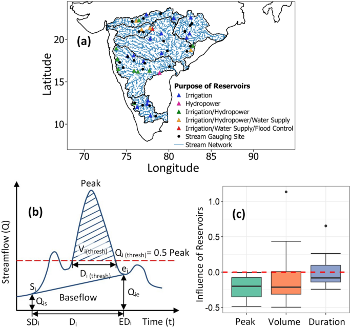
Annual flood magnitudes have declined across most of the catchments. Effect of flow regulations is also assessed to understand the impact of human interventions on flood characteristics. Reservoir regulation has positive effect by reducing the flood peak and volume, whereas the duration of flood events has increased after the construction of dams. Baseflow exhibits similar patterns of trends as floods, whereas trends in rainfall and soil moisture extremes are weakly correlated with trends in flood magnitudes. Baseflow is found to be more strongly influencing the flood magnitudes than soil moisture at various time lags. Further analysis with event coincidence analysis confirms that baseflow has stronger triggering effect on river floods in Peninsular India. https://www.nature.com/articles/s41598-024-51850-w (13 Jan. 2024)
Improved estimation of extreme floods Abstract: -The accurate estimation of flood probability is crucial for designing water storage and flood retention structures. However, the assumption of identical distribution in flood samples is unrealistic, given the influence of various flood mechanisms. To address this challenge, we proposed a novel framework based on flood clustering and data pooling that encompasses the key steps such as 1) flood event separation based on a peak-detection flood separation algorithm, 2) grouping flood events using the k-prototypes algorithm, 3) application of the UN precedented Simulated Extreme ENsemble (UNSEEN) approach to pool reforecast ensemble datasets, and 4) statistical mixing approach to derive common quantiles from all the flood groups.
We applied the framework to the Dresden gauge in the Elbe River for a detailed case study. Various tests have been performed to assess the applicability of the UNSEEN approach and the reforecast dataset consistently shows the potential for data pooling. The proposed methodology outperformed the classical approach in terms of goodness-of-fit. The relative difference between the classical and the proposed approach ((classical-proposed)/proposed) for the 100-year return level is 0.16, with a reduction in root mean square error (RMSE) value from 163 to 98 m3/s. Further, replication of the approach to the gauges in North Germany exhibited a relative difference ranging from −0.3 to +0.15 and produced better estimates in terms of RMSE compared with the traditional model. In summary, the proposed framework offers a better estimation of flood probability by addressing the inherent sample inhomogeneity along with the inclusion of unprecedented flood samples. https://www.sciencedirect.com/science/article/pii/S0022169424000271 (Feb. 2024)
URBAN FLOODS
Chennai Residents seek widening, deepening of Adyar Year after year, whenever the floodgates of the Chembarambakkam Lake are opened, most of the downstream localities in Chennai’s southern suburbs get submerged, causing the residents untold hardships and financial distress. The major reasons are the weak bunds along the course of the Adyar through which surplus water enters the residential areas, the failure to increase the capacity of several lakes, and the absence of check-dams. Therefore, residential areas adjoining the river — such as Mudichur, Manimangalam, Somangalam, Varadarajapuram, Thiruneermalai, Pammal, and Anakaputhur — get flooded.
P. Damodaran, former president of the Mudichur village panchayat, says the reason for the flooding is the poor desilting of the big lakes surrounding Mudichur. If the authorities strengthen the bunds of the river, desilt the lakes properly, and maintain the flood gates well, flooding will not happen in more than six wards of the village, he says. https://www.thehindu.com/news/cities/chennai/southern-suburb-residents-seek-widening-deepening-of-adyar/article67738561.ece (14 Jan. 2024)
DISASTERS
Study Massive tectonic collision causing Himalayas to grow may also be splitting Tibet apart Tibet may be tearing in two beneath the rising Himalayas, with pieces of the continental plate peeling off like the lid off a tin of fish, researchers have discovered.
According to new research presented at the annual meeting of the American Geophysical Union and posted as a pre-peer-reviewed pre-print online, this shows that the geology beneath the world’s highest mountain range may be even more complex than previously believed.
The Himalayas are growing because two continental tectonic plates, the Indian and Eurasian plates, are colliding beneath the colossal mountain range. In cases where oceanic and continental plates collide, the denser oceanic plate slides beneath the lighter continental plate in a process called subduction. When two similarly dense continental plates collide, however — as is the case below the Himalayas — it’s not so simple to predict which plate will end up under the other, and geoscientists are still unsure exactly what’s going on in Tibet.
Some suggest that the bulk of the Indian plate may simply be sliding under the Eurasian plate without diving deeply into the mantle, a process called underplating; others believe that perhaps deeper parts of the Indian plate are subducting, while the upper parts are wedging themselves stubbornly against the bulk of Tibet. The new research suggests that the answer could be both these explanations. The researchers found evidence that the Indian plate is subducting, but it’s warping and tearing as it does so, with the upper half delaminating, or peeling away.
To get a clearer picture of what’s happening below Tibet, the researchers investigated earthquake waves traveling through the crust at the region where the two plates collide. They reconstructed images from these waves showing what appear to be tears in the slab of the Indian plate’s crust. In places, the bottom of the Indian plate is 124 miles (200 kilometers) deep, Science Magazine reported. In others, it is only 62 miles (100 km) to the bottom of the plate, suggesting some of it has peeled away. The new research may also point to areas of increased earthquake risk along the plate boundary, according to Science, though researchers don’t yet fully understand how tearing and warping deep within the crust translates to the buildup of stress at the surface. https://www.livescience.com/planet-earth/geology/massive-tectonic-collision-causing-himalayas-to-grow-may-also-be-splitting-tibet-apart (16 Jan. 2024)
LANDSLIDES
Study An integrated approach of machine learning and remote sensing for evaluating landslide hazards and risk hotspots, NW Himalaya Abstract: Landslides have become more frequent in the last decade in the NW Himalayan region, threatening people and damaging infrastructure. The study presented here aims to identify landslide hazards and risk hotspots in the NW Himalaya. The area is strategically important due the many holy pilgrimage sites and major hydropower projects. A Multilayer Perceptron (MLP) was used to generate the landslide susceptibility map, which was combined with the rainfall intensity map to create the hazard map. To determine the spatial landslide vulnerability, land use and land cover components were taken into account with their respective monetary values.
The landslide risk map is the combination of landslide hazard and vulnerability maps, showing that ∼5% of the area falls in high and very high-risk zones, ∼6% in moderate, ∼47% in low, and ∼42% in very low landslide risk zones. High to very high landslide risk zones are mainly confined to Uttarkashi and its surroundings in the southwestern part of the study area, as well as the Tehri, Karanprayag, and Pithoragarh regions in the southern area. Societal risk was also analyzed and revealed that ∼53% of the human population resides in high to very high landslide risk-prone areas. The findings of this study will be beneficial for promoting sustainable development and safe urbanization in the Himalayan region, if used for planning. https://www.sciencedirect.com/science/article/abs/pii/S2352938524000041 (18 Jan. 2024)
Uttarakhand चमोली जिले में शनिवार (Jan. 20) देर रात बद्रीनाथ हाईवे पर जोशीमठ से लगभग 15 किलोमीटर दूर पांडुकेश्वर की ओर टैया पुल के पास हुआ पहाड़ से कटकर विशाल बोल्डर गिर गया. बोल्डर के गिरने से कई मीटर सड़क को नुकसान पहुंचा है. बद्रीनाथ हाईवे पर सड़क चौड़ीकरण का काम चल रहा था. इंजीनियर और मजदूर सड़क कटिंग के काम में जुटे थे. हादसा के बाद इंजीनियरों और मजदूरों को जान बचाकर भागना पड़ा. गनीमत रही कि बोल्डर गिरने के दौरान कोई वाहन नहीं गुजर रहा था. वरना बड़ा हादसा हो सकता था. हादसा के बाद नेशनल हाईवे बाधित हो गया. वाहनों की आवाजाही को रोकना पड़ा. गोविंदघाट, पंडुकेश्वर, पुलना, लामबगड़ के लोगों की भारी मुसीबतों का सामना करना पड़ा. https://www.abplive.com/states/up-uk/chamoli-badrinath-highway-jam-boulder-fell-on-road-rescue-operation-going-on-ann-2591502 (21 Jan. 2024)
Himachal Pradesh 4-storied building collapses A building, spanning four stories along with its attic, collapsed in a village in the Dhami area on Saturday (Jan. 20), causing damage to the road leading to a government college and impacting traffic movement, according to officials. Fortunately, no loss of life was reported as all residents had been evacuated in advance, and the electric connections to the building were disconnected.The incident occurred around 12 pm at 16 Mile in Marahwag village.
The house, owned by Raj Kumar, was sinking, and the base columns of the building had developed cracks, officials explained. The collapse of the structure caused partial damage to the road leading to the Government Degree College in Dhami, resulting in a disruption in traffic movement, as per officials. Nishant, the SDM Rural, stated that the building collapse was a result of excavation work in the hilly area above the house. He added that Dinesh Kumar is currently constructing his house in the vicinity of the collapsed building. https://timesofindia.indiatimes.com/city/shimla/four-storied-building-collapses-in-himachal-village-traffic-movement-hit/articleshow/107010149.cms (20 Jan. 2024)
DROUGHT
Drought atlas of India is based on the high-resolution Standardized Precipitation Evapotranspiration Index (SPEI). The atlas provides glimpse of past droughts in summer monsoon, winter monsoon, calender year, and water year during 1901-2020. https://indiadroughtatlas.in/
Explainer What are ecological droughts? India recognises and monitors three types of drought – meteorological, hydrological, and agricultural. Now, some researchers are calling for the recognition of ecological droughts, which look at environmental impacts too. Recognising ecological droughts can help make drought management more holistic, by looking at the connections between human and ecosystem vulnerabilities. Ways to measure ecological drought is still an evolving debate. https://india.mongabay.com/2024/01/explainer-what-are-ecological-droughts/ (17 Jan. 2024)
Jharkhand Recommendation for declaring 158 blocks as drought hit CM Hemant Soren directed the disaster management department to prepare a proposal to declare all 158 blocks as drought hit at the earliest, so that it could be placed for approval in the meeting of council of ministers. https://www.deccanherald.com/india/jharkhand/jharkhand-recommendation-made-for-declaring-158-blocks-as-drought-hit-2844088 (11 Jan. 2024)
THERMAL POWER
DTE Policy overhaul needed to address ash pond breaches In recent years, India has witnessed a slew of failures in tailings dams — crucial structures used by mineral processing industries and coal-based thermal power plants to dispose of their dry or semi solid waste called tailings. As India remains reliant on coal for 75 per cent of its energy generation, it is important to maintain the precarious balance between development, energy needs and environmental sustainability. The dams, called tailing storage facilities (TSF), store various types of waste such as pond ash (a mixture of bottom ash and fly ash), bauxite residue (red mud), slag, etc. They are some of the largest structures built and their rate of failure is around 1.2 per cent — about 100 times higher than the failure of conventional water retaining dams. https://www.downtoearth.org.in/blog/pollution/india-needs-policy-overhaul-to-address-frequent-havoc-caused-by-ash-pond-breaches-93984 (19 Jan. 2024)
ENVIRONMENT GOVERNANCE
Gujarat CAG seeks to set up international training centre Comptroller and Auditor General (CAG) of India Girish Chandra Murmu on Thursday (Jan. 18) said that the audit watchdog wants to study the experience of other countries in auditing institutes of local self-governance and set up an international training centre in Rajkot. During his visit to the office of the accountant general (AG) in Rajkot, Murmu said, “We are going to set up an institute here. Our idea is to set up a training institute at the international level for local governments, local administrations… We have taken the initiative and our idea is to start one international class tentatively from April this year,” Murmu said, adding the CAG plans to run the proposed institute out of the existing building of the AG office in Rajkot temporarily. https://indianexpress.com/article/cities/ahmedabad/cag-seeks-to-set-up-international-training-centre-in-rajkot-for-local-administrations-9116372/ (19 Jan. 2024)
CLIMATE CHANGE
Opinion Collectively blind to pollution Harini Nagendra As Canadian writer Margaret Atwood so eloquently pointed out, climate change is ‘everything change’. Economy, society, ecology – they’re all inter-connected and impacted by global environmental change.
Tyres constitute an invisible link between air and water pollution, may have severe impacts on human health. One of the more common chemicals added to tyres across the world for over six decades is called 6PPD. Over time, 6PPD migrates out of the tyre towards the surface — where it gets oxidised by ozone, becoming 6PPDquinone or 6PPD-Q. Recent research has found that this compound is extremely toxic to fish, even in small amounts, leading to massive deaths in some commercially important species like coho salmon. Worn away by friction, when tyres collide with the road, rubber particles containing 6PPD-Q find their way into the air as smog, or are deposited on the soil and road surface. Washed away by the rain, they enter urban water run-offs, making their way into lakes, rivers and eventually into the sea.
The toxicity of this dust on humans has not been well studied, and the absence of knowledge is not comforting. A recent study showed that the chemical was widespread in the rainwater run-off, soil and air across Hong Kong; and an even more alarming study from South China determined that 6PPD-Q was present in urine samples of pregnant women, children and adults. Fortunately, this is also a problem that can be easily addressed, if this compound were to be phased out of tyre manufacturing – though that may be easier said than achieved. https://www.deccanherald.com/opinion/collectively-blind-to-pollution-2848144 (14 Jan. 2023)
SOUTH ASIA
SANDRP Blog DRP NEPAL 2023: Vibrant debate about Hydro Projects This provides an overview of Dams, Rivers & People related issues in Napel in just concluded 2023. While export of hydropower to India is central this year following Nepal PM’s June 2023 visit to India. Pancheshwar, the most ambitious of the projects have seen no real progress in spite of repeated statements. An agreement signed with India to export upto 10000 MW of hydropower in ten years has raised lot of hopes in both countries. The electricity trade has indeed expanded significantly in 2023. There is also renewed hope for Nepal succeeding in export of hydropower to Bangladesh via India, but this still needs some concrete success.
However, most interesting is the vibrant debate in Nepal media about adverse economics, impact on environment, biodiversity and disasters, in addition to displacement risk for thousands of people. Some called it costly madness. It also notes that climate change does not even figure in decision making process. The overview begins with that debate. https://sandrp.in/2024/01/21/drp-nepal-2023-vibrant-debate-about-hydro-projects/ (21 Jan. 2024)
Bhutan DRP 2023: Uncertain fate of mega hydro The Dams, Rivers & People overview of Bhutan here, mainly from media reports from Bhutan, highlights the failed hydropower goal of adding 10000 MW capacity by 2020. The fate of the 1200 MW Punatsangchu I remains uncertain, yet to be decided if the dam will be abandoned for barrage. The flood disaster in July 2023 that washed away 32 MW Yungichhu HEP and killed about 23 people was possibly sign of things to come, as shown by the washing away of the 1200 MW Teesta 3 project in neighbouring Sikkim in early Oct 2023 with GLOF. On positive side, Bhutan has decided to go for Solar and Wind. The Nikachhu HEP is likely to be commissioned soon, adding 118 MW to Bhutan’s installed capacity. https://sandrp.in/2024/01/22/bhutan-drp-2023-uncertain-fate-of-mega-hydro/ (22 Jan. 2024)
DRP BANGLADESH 2023: Rivers dominate in a River Intense Nation In this overview of 2023 issues related to Dams, Rivers and People in Bangladesh, we see how rivers dominate the discourse in one of the most river intense nations of the world. As expected, as India and Bangladesh share the rivers in so many ways, the bilateral issues also dominate. These includes fisheries, power sharing, navigation, besides of course water sharing. As expected, Teesta water sharing issue dominates more than others. Please Read, Share https://sandrp.in/2024/01/19/drp-bangladesh-2023-rivers-dominate-in-a-river-intense-nation/ (19 Jan. 2024)
Nepal Foreign (Chinese) investment of about Rs. 20 billion out of total project cost of Rs 25 B has been mobilized for the 120 MW under construction Langtang-Bhotekoshi Hydroelectricity Project based in Rasuwa. https://english.khabarhub.com/2024/15/335637/ (15 Jan 2024)
CHINA
The 22 Jan 2023 landslide at Zhenxiong in Yunnan Province Dave Petley There is no word on the trigger of this event. The area appears to be mantled in recent snow, so it is unlikely to have been rainfall. The image above shows that the landslide is a rock slope failure, with a vertical rear release surface that is clearly an existing joint, and a steeply inclined basal shear surface that may also be an pre-existing discontinuity. The main failure appears to have entrained debris from the lower part of the slope. There is an intriguing vertical scarp in the landslide scar at the foot of the main rock slope that would be worth investigating. https://eos.org/thelandslideblog/the-22-january-2023-landslide-at-zhenxiong-in-yunnan-province-china (22 Jan. 2024)
EUROPE
EU Parliament on January 17 2024 adopted a report\motion “EU development cooperation in support of access to energy in developing countries”. They mention hydropower and dams 20 times, mostly listing risks and shortcomings on all fronts. Finally they request that no large hydro should be supported unless it satisfies all Guidelines of 2000 Report of the World Commission on Dams. https://www.europarl.europa.eu/doceo/document/TA-9-2024-0031_EN.pdf (17 Jan. 2024)
THE REST OF THE WORLD
USA Public input sought on $12M proposal to decommission dams In two different community halls over Thursday afternoon, the Natural Resources Conservation Service presented its plan to decommission all but one dam between the Coon Creek (Minnesota state) and West Fork Kickapoo (Wisconsin state) watersheds. In 2018, historic rainfall of 11 inches in a six-hour span breached five dams across the two watersheds. The extensive damage downstream in Coon Valley and Vernon County destroyed homes, roads and farmland. The dams suffered sudden failures after internal erosion weakened their ability to support the rainfall of a 500-year storm event like the 2018 flood. Because internal erosion is difficult to detect, the next flood could breach any of the dams suddenly and catastrophically.
– WHY DECOMMISSION? When all had settled after the 2018 breaches, a choice was left in the air on what would happen next to these dams. The Natural Resources Conservation Service’s preferred decision was decommission over repair and rebuilds, considering all the costs and benefits. Only the Jersey Valley Dam, the West Fork Kickapoo watershed passed the test and has been recommended to be retained. There will be some limited cost to respective counties for administration and permits, but the decommissioning is otherwise funded by the federal govt at an estimated $12 million.
– NEXT STEPS: The Natural Resources Conservation Service and others on the project will take public comments online until Feb. 20. All comments will be addressed and entered into the official record for project managers to consider. A final plan will be made available around April 1 for the public and counties’ considerations. After 30 days, the plan will go to the Natural Resources Conservation Service and county boards for consideration. Funding can then be requested to deconstruct the dams. The dams will be decommissioned by creating large notches into the earthen structures. This prevents a large sediment exodus downstream while still letting water flow more freely. For the Natural Resources Conservation Service, this would be the end. https://lacrossetribune.com/news/local/vernon-monroe-county-dam-decommission/article_ac76e1a6-b699-11ee-967f-83c335cc01b5.html (19 Jan. 2024)
SANDRP
Also see: DRP 15 Jan. 2024 & DRP 08 Jan. 2024
Follow us on: www.facebook.com/sandrp.in; https://twitter.com/Indian_Rivers
