Even as the sun was harsh on the streets of Baner, the banks of River Mula were lined with ancient willows, their branches brushing against the flow. Crinum lilies softened banks and in a months’ time, they will burst in white, fragrant blooms. Gnarled roots of Karanj (Pongamia pinnata) tree, immortalized in Indian literature as the river’s companion, made walls along the riverbanks making sure that the banks will not get washed away in a flood.
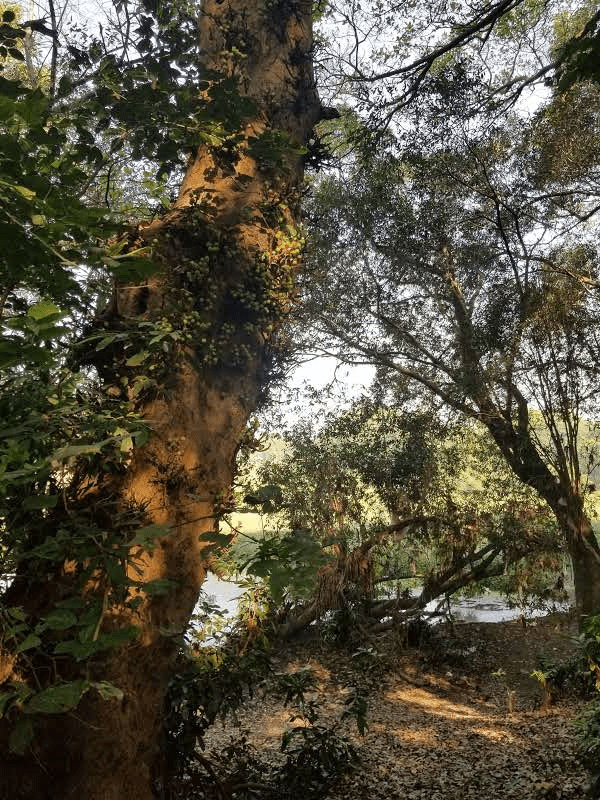
Riparian banks of Mula RIver, Pune Photo: Parineeta Dandekar
This tiny, verdant oasis is beautiful, of course, but performs invaluable ecological services for the city. Riparian areas (specialized vegetation on the riverbanks) help regulate floods, protect riverbanks from erosion, reduce water pollution, maintain water temperature, and create ecological habitat for several species[i].
“This bank is marked as concrete embankment zone in the DPR of proposed Riverfront Development Project.” Shailaja Deshpande of Jeevit Nadi (Living River)[ii] told me.
How was that even possible? How can we think of replacing this invaluable riparian area with a concrete embankment?
Pune’s proposed Riverfront Development Plan plans to destroy riparian areas, pinch the river, reduce its width, create three large dams inside the river, and raise concrete embankments along riverbanks. All this for “Improving rivers quality, protecting floods, and making a continuous public access.” It fails on all of these stated objectives.
Is there a different way of managing urban rivers?
Across the world, as cities are facing changing climate, increasing water demands and increasing pressures on urban rivers and floodplains, it is gradually becoming clear that urban water management paradigms of more concrete, increased water velocity, development close to the rivers are no longer serving the cities. There have been significant efforts across the world to manage rivers in a novel way: one that does not view nature as an adversary, but as a formidable ally to work with. It is important to take stock of changing global approaches to learn better ways of living with our rivers.
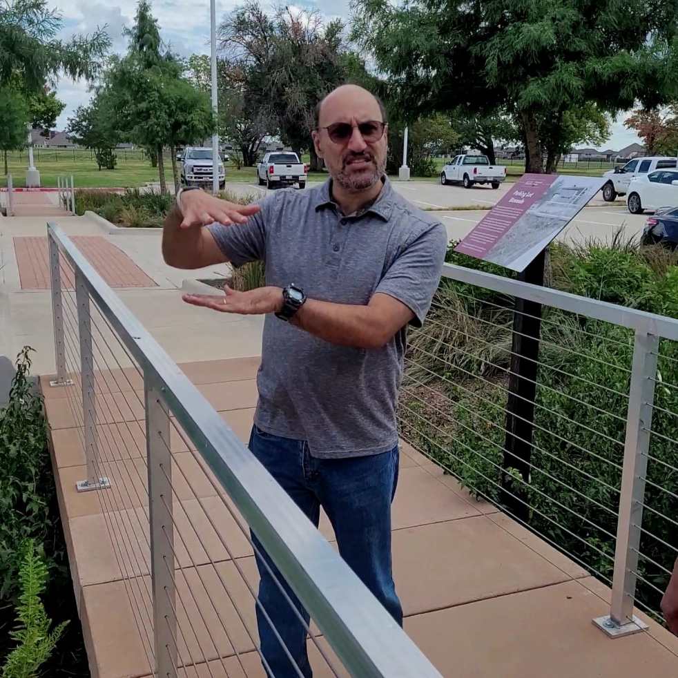
I met Dr. Foaud Jaber, Professor and Extension Specialist in Integrated Water Resources Management, Texas A&M AgriLife Extension in Dallas in August 2022[iii]. I had attended Urban Stream Restoration Workshop organized by Texas Riparian Association and Texas A&M Agrilife Extension[iv] led by Dr. Jaber and his team. The workshop helped us understand the language of a river through pebbles, meanders, sediments, and flow velocities. Dr. Jaber mentioned various interesting restoration projects he and his team are working on, and I had to meet him to know about them further. https://www.youtube.com/watch?v=wcsR6D5knIY
Dr. Jaber explaining bankfull width of a channel in the Urban Riparian and Stream Restoration Workshop at San Marcos, Texas
Following is an interview we conducted at Texas AgriLife Extension in Dallas[v] to understand practical aspects of stream restoration and green stormwater infrastructure (GSI) or Water Sensitive Design/ “Sponge City” and how nature- based solutions can be cheaper and more effective in managing urban water.
Question: If an urban area wants to attempt River/ Stream restoration, what are the steps to be followed? What are the steps your team follows?
Dr. Jaber: The first step of any project is assessment of project area. We go down to the stream/river to understand it’s condition: Is it entrenched? Is it deep? What are the angles of the bank? How is the riparian vegetation? We rate stream condition from one to five to understand where it stands. City Officials let us know the problem areas. We the look at satellite imagery of the watershed, and through tools like Google Earth, try to understand the historic changes in the watershed. This helps us in forming a preliminary idea about further action.
We take measurements of cross sections, channel profiles, slope of stream bed, banks angles, estimation of Bank Erosion Hazard Index (BEHI)[vi] and assessment of riparian vegetation. We then go back to the City (civic administration) with a rough idea of the project and come up with a plan with budget.
Before starting with the design, we try to find a healthy reference-reach with similar characteristics like stream class and watershed and start modelling with engineering and details. If there are budget constraints, we suggest small, local improvements in channel, riparian restoration activity, plants that can be introduced, replanting edges, etc. In case remeandering is not possible, we recommend practices like vanes[vii] to force water in middle stream rather than hitting banks to reduce erosion. Whether the budget is small or large, there are always some steps which can be taken to help the river recuperate. Such projects can be seen at places like Harris County[viii] (a part of Houston, Texas) and Junction, Texas [ix]. We need more such projects.
As compared to states like Virginia or North Carolina, Texas needs more restoration expertise and projects. Even today, channelization is a part of conventional erosion control in Texas. There are several reasons for it like competing benefits, different agencies responsible for flood control and ecology. So, when there are only moderate water quality issues and there is money to fix it, restoration, rechannelisation, remeandering can be implemented. But if a major flood has happened at the site, flood control agency has a priority. Then channelization, widening, lining with concrete, and other practices which considered green, but are not, like gabion and riprap are done.
Q: In your experience, have you seen river restoration work also reduce flooding?
Dr. Jaber: As watersheds urbanise, we have more water going into rivers and rivers are not able to hold water in bed, causing flooding. Because of the faster flow, channels erode, deepen, widen, lose ecological functions and become unmanageable.
We try to implement Natural Channel Design or Green Design in the restoration project. Channel restoration is aimed at a system that has stable flow, sediment movement, and ecological functioning. But this does not specifically stop flood. This needs space, which is not always available. In addition, if the watershed develops further after restoration project, runoff will increase. If we design a channel for a 2 inch or a 4 inch storm and it gets a 5 inch storm, all the good work is going to be lost. So, if flood control is one of the objectives, then we need to work in the entire watershed and not just the channel.
Therefore, we recommend use of Green Stormwater Infrastructure (GSI)[x] in the catchment before it ends in the stream. Green Stormwater Infrastructure and natural channel restoration go hand in hand. New developments must integrate GSI because they affect the flow. Similarly, if a channel must integrate dam releases from the upstream, the system has to follow watershed approach.
There is no alternative to integrating Climate Change considerations and watershed approach even in conventional stormwater planning now. Even if you build a trapezoidal concrete channel, take down houses, kill all plants and design it for 100 years storm (let’s say), you can very easily get a bigger flood event. So even a mega channel is going to flood. There is no alternative to system-wide changes.
Also, if you design a concrete channel for one mile, when you stop (you have to stop when there is no money!) water is going to be faster and bigger in the natural channel. This healthy channel will start flooding and eroding. With a concrete channel approach, you simply end up moving the problem downstream. (video)
You can see this at many places. The same problem arises when rivers are put in pipes and become a part of the stormwater system. Concrete is smoother, water flows faster, and when the pipe daylights, there is huge erosion. Putting rivers in pipes is a sure way to flood. One problem is pipe size. During large storms, pipes back up and flood streets. River Trinity did not overflow its banks during the last 1000-year-flood event, but flooding happened with stormwater network flooding streets and underpasses. This causes urban flood.
Q: How can Green Stormwater Infrastructure help reduce urban flooding?
Dr. Jaber: Green Stormwater Infrastructure (GSI) includes interventions like Rainwater harvesting, Rain gardens, Bioretention areas, Green roofs and Permeable pavements, etc. (In 2019, Congress enacted the Water Infrastructure Improvement Act, which defines green infrastructure as “the range of measures that use plant or soil systems, permeable pavement or other permeable surfaces or substrates, stormwater harvest and reuse, or landscaping to store, infiltrate, or evapotranspirate stormwater and reduce flows to sewer systems or to surface waters.”)[xi]
In a latest study we did with The Nature Conservancy, we modelled the entire city of Dallas Fort Worth for Green Stormwater Initiatives ( Green roof and rainwater harvesting on every building, bioswales for all parking lots, rain gardens and retention ponds) and what we found was:
- GSI costed 77% less than upgrading to gray infrastructure alone to meet modeled overflows; a combination of green and gray provides the maximum cost-effective benefits.
- GSI was found to reduce overflows for all storms modeled by 17-31% and to delay peak flows potentially reducing areal flooding, creek flows, and overbank flooding.
- Climate change is predicted to increase the number and the overall impacts of stormwater “system hotspots”—locations where the drainage network is undersized and likely to contribute to inlet overflows and areal flooding during rain events. For the storms modeled in this study, climate change resulted in an average increase of 26% in the number of drainage system hotpots, compared to current conditions.
- Of the systems studied, bioretention areas—particularly in parking lots—offer the greatest opportunities for community impacts. Bioretention areas can capture, treat, and infiltrate portions of surface stormwater runoff through engineered soil, before draining to the gray stormwater network. Rain gardens and cisterns were also found to offer substantial distributed opportunities for health and resilience.[xii]
What we found was that green infra can reduce 35% water in these storms flood water. Only making pipe system bigger (Grey infrastructure) will take care of only 40% floods as there is a limit to how much you can increase. We recommend that a combination of GSI and Grey infra will take care of more than 70% flood water. Cost per gallon water retained in GSI compared to pipes was 1/7th flowing through a large new pipe. So, If you have less money, put green infra first, which will take care of 35%, then if you have money you can put capital infra projects taking care of another 40% and then look at underground large storage, detention ponds to take of remaining part.
Initially, Green Stormwater Infrastructure initiatives were only used for water quality, for cleaning the first wash before it is harvested. So, the systems were designed to handle a small quantity of water, about 2 inch storm. However, we have shown that GSI can be an important urban flood control measure if implemented on a bigger scale. However, it needs educated maintenance. It’s not a pipe, but a garden: a living thing.
Q: In Pune and many Indian cities, Dam management in the upstream of cities compounds urban floods. How can Restoration or Water Sensitive Design help here?
Dr. Jaber: Stream/ River Channel restoration works are done for a design discharge, and they cannot accommodate sudden high flows like dam discharge. However, a floodplain can be developed to catch more rain. During Hurricane Harvey[xiii] in Texas in August 2017, Addick’s and Barker Reservoirs held up water and then had to release it in large volumes, causing damages to homes in the upstream as well as downstream. Major lawsuits are now being filed against the Army Corps of Engineers related to dam operations
(Note: Nearly 8000 residents filed claims against the Army Corps of Engineers about dam operations. For more: https://fnj-law.com/hurricane-harvey-victims-score-big-win-following-u-s-court-of-appeals-dismissal-reversal/)
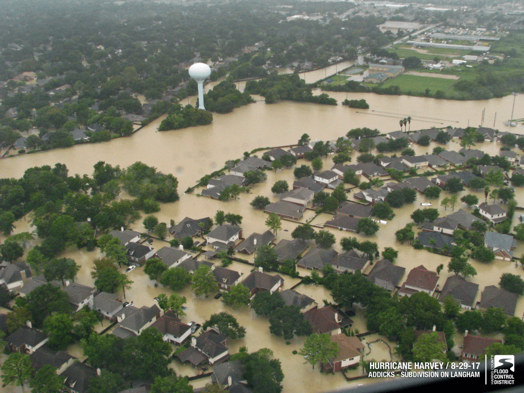
Flooding d/s Addick’s Reservoir during Hurricane Harvey in Houston Photo: Houston Public Media
Harris County Flood Control District [xiv]is looking at various ways to reduce the flood peak at Addick’s and Barker Reservoirs and one of the most efficient ways is to restore the Katy Prairie (native grasslands) in the upstream of these reservoirs to retain and detain floodwater. In a modelling study we did, in scenarios where even if 25% or 50% of the prairie land is restored, flood reduction benefits at Addick’s Reservoirs are between 20-35%.[xv] This reduction is highly significant as it comes with other biodiversity benefits too. Similarly, San Antonio River Authority[xvi] is working on Green Infrastructure and Rosgen type of work too for flood control. (Look at completed projects here: https://www.sariverauthority.org/green-stormwater-infrastructure-gsi)
The interview concluded with Sarang Yadwadkar joining us on a call from Pune, discussing the Pune Riverfront Development Project. Dr. Jaber expressed concern about putting the river inside levees as the erosion from channel is higher where levees end, also floodplains are starved of sediment. He shared that stable sediment load is important for the banks and by cutting off sediments, floodplain habitats are starved of nutrients. Where the levees end, water velocity is higher, its elevation is higher and it causes destabilization and erosion.
Dr. Jaber then showed us Green Stormwater Initiatives at work in the Texas Agrilife Campus. We also met a group from Hyderabad which was researching the impact of Green Stormwater Initiatives in regulating Hyderabad floods. It was indeed great to see the group. Let us hope that Smart Cities in India and worldover actually become water smart by working with and not against rivers and water.
How bioswales in Parking lots can reduce flooding
Parineeta Dandekar, parineeta.dandekar@gmail.com, SANDRP
[i] https://www.sciencedirect.com/topics/agricultural-and-biological-sciences/riparian-buffers#:~:text=Riparian%20buffers%20are%20placed%20between,harvestable%20products%20(Figure%207).
[ii] https://www.jeevitnadi.org
[iii] https://baen.tamu.edu/people/jaber-fouad/
[iv] https://urbanriparian.twri.tamu.edu
[vi] https://feh.iupui.edu/tools/bank-assessments/behi/
[vii] https://ascelibrary.org/doi/10.1061/%28ASCE%29HY.1943-7900.0000217
Vanes are structures constructed in a stream to redirect flow by changing rotational eddies (i.e., secondary flows). They are used as part of natural stream restoration efforts to improve instream habitat and prevent bank erosion.
[viii] https://www.stantec.com/en/projects/united-states-projects/k/katy-prairie-stream-restoration
[ix] https://www.depts.ttu.edu/junction/lrfs/
[x] https://www.nature.org/content/dam/tnc/nature/en/documents/GSIanalysisREVFINAL.pdf
[xi] https://www.epa.gov/green-infrastructure/what-green-infrastructure
[xii] https://www.nature.org/en-us/newsroom/green-stormwater-infrastructure-research-dallas-texas/?fbclid=IwAR0LV0-0YS5UNGsRawXbXFapXiJ1RHIfmNuSfQh-Pj9LzRfiX-v0Tapzcb4
[xiii] https://www.weather.gov/hgx/hurricaneharvey
[xiv] https://www.hcfcd.org/Z100-00-00-Y106, https://www.hcfcd.org/About/Flooding-and-Floodplains, https://static1.squarespace.com/static/61d4a59b5ae1d669bc1829b7/t/625d933ee70ae81446dc191d/1650299717504/CPC+Plan+to+Reduce+Flooding.pdf
[xv] Jaber et al, Evaluating the Impact of the Katy Prairie Hydrology on Flooding Using SWAT Modeling, Draft
Final Report, 2020
