Krishna basin is again facing unprecedented floods, for the second straight year. Unprecedented is a bit of overused word these days, but consider the facts: At no less than ten locations, the Highest Flood Levels (HFL) ever recorded at those locations in the Krishna basin were surpassed (nine locations) or equaled (one location). Some of the HFLs surpassed this year were amazing 56, 51 and 44-year-old records! And imagine most of this happening in second half of Oct 2020, when South West monsoon is traditionally over by end of Sept! There is no doubt the floods were unprecedented.
However, the floods this time are different than last year[i] in a number of ways. Floods this year happened, not on main stem of Krishna basin or in Upper Krishna basin of Maharashtra and Karnataka as it happened last year. This year the HFL crossing sites were on less celebrated tributaries of Krishna River, like Don (1), Kagina (2), Musi (2), Nira (1) and Bhima (4). Don and Musi are Krishna tributaries, while Kagina and Nira are Bhima tributaries. The floods were spread over four states of Maharashtra, Karnataka, Telangana and Andhra Pradesh, though HFL events were at first three states.
The floods left a huge trail of destruction in all four states. The biggest impact was on farmers as most of the places the crops that were ready to be harvested got destroyed. Houses, roads, tanks and vehicles were destroyed in large areas. Thousands of people had to be relocated in Maharashtra, Karnataka and Telangana.
The final flood pulse of this episode is still travelling down the Bhima basin at Yadgir in Raichur district in Karnataka. It travels from here to Bhima confluence with Krishna and then travel to PD Jurala dam, and then to Srisailam dam, Nagarjun Sagar Dam, Pulichintala dam, Prakasham barrage and then on to Krishna delta connecting to Bay of Bengal.
The floods were result of heavy rainfall due to the low pressure over Bay of Bengal converting to a deep depression[ii] and travelling east to west from Andhra Pradesh to Konkan via Telangana, North Interior Karnataka and Madhya Maharashtra. This deep depression and possible path and heavy rainfall areas were forecast well in advance. But we do not find any advance action in terms of depleting the reservoirs even after the forecast was made.
In what follows we provide the state wise details of HFL crossing sites and hydrographs.
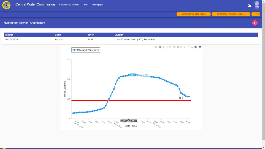
TELANGANA: Anantharam This site on Musi River, a tributary in Krishna, is located in Nalgonda district of Telangana. The previous HFL (228.92 m achieved in Sept 26, 2020, the site has been added in CWC FF only in 2016, CWC FF Director informed SANDRP) at this site was crossed by a massive 1.29 m and the water level here remained above the old HFL for a huge 56 hours, starting at 2200 hours on Oct 13.
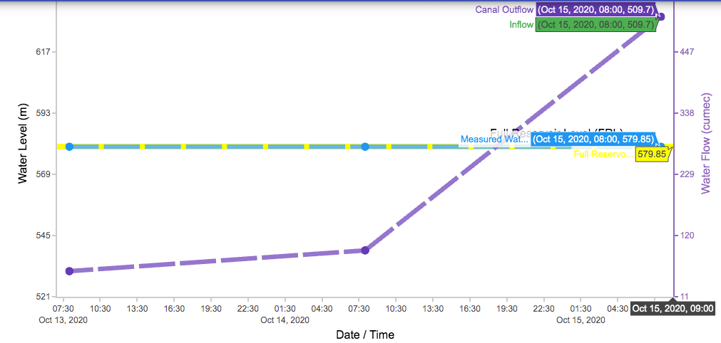
Valigonda At this site also on Musi River in Nalgonda district of Telangana, the water level reached the HFL level of 306.28 m at 0800 hours on Oct 14, as we can see from the following hydrograph from CWC FF (Central Water Commission Flood Forecasting) website[iii]. CWC FF Director Shri Sharad Chandra informed SANDRP that this site has been added only in 2019.

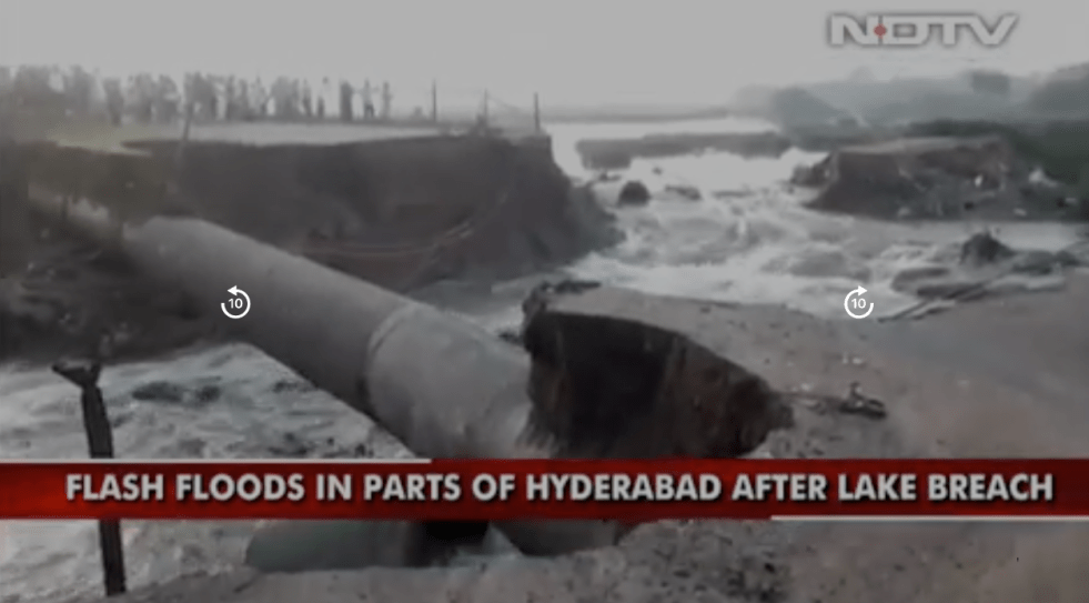
Unprecedented situation at Musi Dam, question mark over dam safety The 57 year old Musi dam on Musi river located at Bopparam village of Kathepally mandal of Nalgonda district is downstream from above two sites with Full Reservoir Level (FRL) of 196.6 m (645 ft). It’s bund was first time breached[iv] by the officials of irrigation department on Oct 13, 2020 to save the project in view of record levels of water inflow to the dam. The State government has taken up modernization of Musi project with Rs 65 crore in 2017 and installed new crest and regulatory gates in place of rusted ones in addition to strengthening the bund.
A detailed report by The Hindu[v] raises many questions about the safety of the Musi Project. The project faced one of the biggest tests of flood this year. The dam can hold 4.46 tmc ft water at FRL of 645 feet, it has set new records this season. Not only has the impounded water crossed the FRL by up to three feet, but also the outflow, on Oct 14 alone, was an unprecedented 16 tmc ft, 3.58 times the project’s gross capacity. The total discharge of the two successive days was 25 tmc ft. The officials breached a section of the dam to let out up to 25,000 cusecs of water. The dam was breached near the abutting Ratnapuram village in “an emergency move”.
According to records, the 1983 flood saw the maximum inflows of about 2.28 lakh cusecs, in comparison the project received nearly 2.5 lakh cusecs this year. The spillway capacity of the project is 4 lakh cusecs or 11320 cumecs, but the project could not handle even 2.5 lakh cusecs and the bund had to be breached to flood additional areas. District Minister and Energy Minister G. Jagadish Reddy said: “This is an unprecedented flood, from Hyderabad and Bikkeru Vagu, receiving more than 2 lakh cusecs. We breached a section of the dam and officials are monitoring the levels.”
Maintenance of the project was in question in October 2019, when a gate got washed away, and more than 4 tmc ft impounded water, at 643 feet, drained in a few days. This brought into focus the maintenance as all the gates that had been replaced with new ones at an estimated cost of ₹18 crore in 2015.
On October 14, when 13 gates (of the total 12 crest gates and eight regulatory gates) were operated to a height of 10 feet, crest gate no. 9 failed to open as its counterweight had snapped in August 2020. The 35-ton beam did not break the gate, but fell away. The gate is not working well, the officials agree.
On Oct 20, when The Hindu correspondent visited the site, workers and welders were busy patching up the foot of regulatory gate no. 2. Other gates also show leakages, or throw up problems at closing and opening, officials said. It is not just the gates, the dam “is also visibly old, with the meagre staff that is ready for retirement, and the decrepit stairs and cracked structures. The border railings of the earth dam and the gate columns, braced with sticks and wires like bandages, welcome officials and visitors alike.”
Jewangi At this site on Kagna (also spelt by CWC FF as Kagina elsewhere) River (tributary of Bhima river) also in Nalgonda district of Telangana, the old HFL of 426.96 m (attained in 1990) was breached and the new HFL is 0.84 m above the old HFL and water level remained 9 hours above the old HFL, between 1400 and 2300 hrs on Oct 14.

KARNATAKA
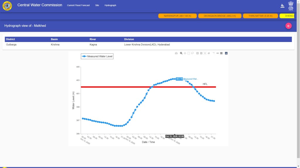
Malkhed: 56 year old HFL breached This site, also on Kagna river in Gulbarga district of Karnataka had the HFL of 401.995 m, attained on 17.09.1964. It means that this record has stood for over 56 years and was not broken by any of the floods that came all these years! It was breached at 1300 hrs on Oct 14, an hour before the HFL at Jewangi in Telangana on the same river, upstream from Malkhed was breached. The new HFL is a huge 1.195 m above the old HFL and remained above the old HFL for 22 hours.
Talikot This site on Don River (a tributary of Krishna River) in Bijapur district of Karnataka had one-year-old HFL of 501.91 m. This was breached at 1100 hrs on Oct 15 and new HFL is 0.3 m above the old HFL. The water level remained above the HFL for 14 hours. The Don river confluences with Krishna river downstream of Narayanpur dam (FRL 492.25 m), upstream of Huvinhedigi site (HFL 358.55 m) on Krishna river in Raichur district of Karnataka.

Yadgir This site on Bhima River in Gulbarga district of Karnataka breached earlier HFL of 361.913 m, attained on 07.09.1969, over 51 years ago! The HFL was breached at 0100 hrs on Oct 16, it reached a new HFL that was 0.11 m above the old HFL and the water level remained above old HFL for 8 hours. This was possibly the impact of flood pulse brought to Bhima by Kagna river, that confluences with Bhima, upstream from this site, in Gulbarga district of Karnataka.

Deongaon Bridge This site on Bhima River in Gulbarga district of Karnatka is at a location not very far from where Bhima enters Karnataka from upstream Maharashtra. The old HFL of 407.34 m attained on 13.08.2006 was breached at 0200 hrs on Oct 17 and the new HFL was massive 1.66 m above the old HFL. The water level also remained above the old HFL for huge 53 hours.

The flat hydrograph at the peak at this site is because this site is just downstream of the Sonna barrage. The Sonna barrage stored up a huge quantity of water, and then gradually released it, which led to the peak remaining flat for so many hours.
Some key salient features of Sonna Barrage[vi] on Bhima River: FRL: 405.38 m; MWL: 409 m; Spillway capacity: 6.32 L cusecs.

MAHARASHTRA The deep depression caused rainfall clouds travelled to Maharashtra on Oct 14-15, leading to heavy rainfall in Pune and Solapur districts in Bhima basin and Kolhapur-Sangli-Satara districts mostly in upper Krishna basin.
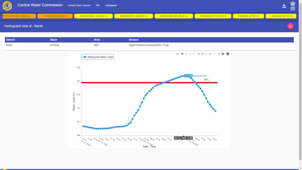
Sarati This site on Nira river, a tributary of Bhima river, in Pune district of Maharashtra, had HFL of 476.788 m, attained on 02.08.1976, over 44 years ago! The HFL was breached at 1200 hrs on Oct 15 and new HFL of 477.808 m was attained, huge 1.02 m above the old HFL and water level here remained old HFL for 16 hours.
Upstream from this site is the Veer Dam on Nira river. As we can see from the hydrograph of the dam, the dam was maintained at FRL through this episode, allowing all the inflows to flow downstream. This when IMD had forecast the high rainfall event in advance.
Same was true for the Ujani dam on Bhima river.

Nira river confluences with Bhima river in Solapur district, downstream of Ujani dam, but upstream of the holy Pandharpur town. Downstream from Pandharpur town, Manganga river meets Bhima also from right.
Solarpur district was one of the worst affected districts in this round of floods, since the relatively arid and flat district does not have the required drainage system to ensure that flood water is drained out without too much damage. Thousands of people were trapped in these floods. Salutes to Koli (boatpeople, fisherpeople) of Pandharpur in Solapur district who rescued literally thousands of people during floods along Chandrabhaga river (another name for Bhima river) around Oct 14, 2020[vii].
Wadakbal This site on the Bhima river in Solapur district of Maharashtra had HFL of 428.563 m attained on 29.09.1989, 31 years ago. It was breached at 2200 hrs on Oct 15, 2020. New HFL is now 0.767 m above the old HFL and water level remained above the old HFL for 26 hours.

Takli This site on Bhima river in Solapur district of Maharashtra had HFL of 423.718 m, attained on 12.08.2006, 14 years ago. At this site Bhima forms the boundary between Karnataka on the right and Maharashtra on the left. The HFL was crossed at 1800 hrs on Oct 16, 2020 and the new HFL here now is 0.67 m above the old HFL and water level remained above the old HFL for 34 hours. The water level here came below the HFL by 0400 hrs on Oct 18. Water level however, remained above HFL at Deongaon for further 27 hrs, due to the role of the Sonna barrage on Bhima River in Gulbarga district, just upstream of the Deongaon Bridge site.

Summary The following table provides the details of the HFL crossing (or equaling in one case) sites in Krishna river basin in Oct 2020. This list is in addition to the list of 37 sites we published earlier[viii] where the HFL was crossed in the South West Monsoon 2020. So total number of sites where HFL has been crossed in 2020 monsoon is already 47.
Rivers in Krishna basin breaching HFL in Oct. 2020
| SN | River/ Site | Basin/ District | Old HFL(m)/ Date | New HFL (m)/ Date | Breaching HFL after years | Breach/ Fall time | Hours above HFL | Gap between New/Old HFL (m) |
| Telangana | ||||||||
| 1 | Musi Anantharam | Krishna Nalgonda | 228.92 m ? | 230.21m 13.10.2020 | 13.10.2020 22:00 hrs to 16.10.2020 06:00 hrs | 56 hrs | 1.29 m | |
| 2 | Musi Valigonda | Krishna Nalgonds | 306.28 ? | 306.28 14.10.2020 | – | 14.10.2020 0800 | 0 | 0 |
| 3 | Kagna Jewangi | Krishna Ranga Reddy | 426.96 m 15.08.1990 | 427.8 m 14.10.2020 | 30 | 14.10.2020 14:00 hrs to 23:00 hrs | 9 hrs | 0.84 m |
| Karnataka | ||||||||
| 4 | Don Talikot | Krishna Bijapur | 501.91 m 20.10.2019 | 502.21 m 15.10.2020 | 1 | 15.10.2020 11:00hrs to 16010.2020 01:00 hrs | 14 hrs | 0.3 m |
| 5 | Bhima Deongaon | Krishna Gulbarga | 407.34 m 13.08.2006 | 409 m 17.10.2020 | 14 | 17.10.2020 02:00 hrs to 19.10.2020 07:00 hrs | 53 hrs | 1.66 m |
| 6 | Kagna Malkhed | Krishna Gulbarga | 401.995 m 17.09.1964 | 403.19 m 14.10.2020 | 56 | 14.10.2020 14:00 hrs to 15.10.2020 12:00 hrs | 22 hrs | 1.195 m |
| 7 | Bhima Yadgir | Krishna Gulbarga | 361.913 m 07.09.1969 | 362.023 m 16.10.2020 | 51 | 16.10.2020 01:00 hrs to 09:00 hrs | 8 hrs | 0.11 m |
| Maharashtra | ||||||||
| 8 | Nira Sarati | Krishna Pune | 476.778 m 02.08.1976 | 477.808 m 15.10.2020 | 44 | 15.10.2020 12:00 hrs to 16.10.2020 04:00hrs | 16 hrs | 1.02 m |
| 9 | Bhima Wadakbal | Krishna Solapur | 428.563 m 29.09.1989 | 429.33 m 15.10.2020 | 31 | 15.10.2020 22:00 hrs to 17.10.2020 00:00 hrs | 26 hrs | 0.767 m |
| 10 | Bhima Takli | Krishna Solapur | 423.718 m 12.08.2006 | 424.5 m 16.10.2020 | 14 | 16.10.2020 18:00 hrs to 18.10.2020 04:00 hrs | 34 hrs | 0.782 m |
This narrative of the Oct 2020 floods in Krishna basin spread across at least three states raises many questions, including on rainfall forecasting by IMD, flood forecasting by CWC, operation of dams and management of the disaster. It has left behind a huge trail of destruction in the affected areas, most prominently for the poor and the farmers. This kind of events are likely to come with increased frequency. Least that the NDMA can do is to institute an independent assessment of this whole episode to see what lessons we can learn, so that the impacts can be reduced in future.
Himanshu Thakkar (ht.sandrp@gmail.com), Bhim Singh Rawat, SANDRP
END NOTES:
[i] https://sandrp.in/2019/10/29/rivers-that-cross-highest-flood-level-during-sw-monsoon-2019/
[ii] https://indianexpress.com/article/explained/explained-tracking-the-weather-system-that-gave-hyderabad-its-rainiest-day-ever-6758111/
[iv] https://telanganatoday.com/officials-breach-musi-project-bund-to-control-heavy-inflow-of-water
[v] https://www.thehindu.com/news/national/telangana/recent-floods-continue-to-test-musi-project/article32902841.ece
[vi] http://waterresources.kar.nic.in/salient_features_bheemalift.htm
[vii] https://m.hindustantimes.com/cities/hooked-on-to-saving-lives-koli-community-rescuers-step-up-to-every-river-challenge-in-pandharpur/story-XbiKpQwvPNwDCPzPq6V9cM_amp.html
[viii] https://sandrp.in/2020/10/03/rivers-that-reached-new-highest-flood-level-during-monsoon-2020/
