Guest Blog by Mohit M Rao
The impetuous flow of River Betwa is the lodestar for Astha Choudhary and Mohit M. Rao, who for the first 14 days of December 2019, walk from the historic city of Orccha to the confluence of Betwa and Bina rivers. The walk, as part of Veditum’s Moving Upstream fellowship, traverses through forests, endless fields of florescent-green wheat fields, overflowing streams and the rocky banks of the river. Fueling the 270-km journey is the kindness of villagers along the way.
The map below depicts the walking route, stretching to some 270-km, from Orccha to Padoccha in the South where the Betwa and Bina rivers converge. The 14 day journey saw us halt in the friendly homes of villagers or in temples or religious institutions for the night. Three major dams and two barrages were seen along the way. The photo story aims to encapsulate the landscape, its forests and the joys and concerns of the riparian communities for whom River Betwa is a lifeline.

Orccha shimmers through the wintery haze
 The rising sun is an insignificant spot in wintery, hazy sky. Our journey through Bundelkhand starts at Orccha, a historic town which on December 1 had been decked up to commemorate the marriage of Lord Ram. The Chattris themselves are an abode to numerous species of vultures. A bounteous monsoon in 2019 sees the Betwa flow with some ferocity. The silhouettes of the Royal Chattris tower over the landscape of fields, streams, river and denuded forests for kilometers. Photo credit: Mohit M. Rao
Creating a field
 As an aging labourer who could no more offer the strength of his body, Ganesh, from the Sorr tribal community, left Orrcha and settled on an unclaimed land by the Betwa. Here, the river gushes over a series of boulders, and during the monsoons, reclaims its banks. Around 5 years ago, he carved out a 3-bigha (0.75 acre) farm by single-handedly clearing out large boulders strewn across the banks. Perhaps, the greater challenge was to regularise this land: multiple visits to government offices and bribes that took away his savings. In the twilight of his life, he clasps his independence tight: A house of stone and thatched roof shelters him, while he subsists on the crop of wheat and vegetables. Photo credit: Mohit M. Rao
Grazing in a desolate landscape
 By all accounts, the large patch of land between Marod village and the Betwa was once a thriving, wooded forest. Now, the brown of the soil that stretches for miles is broken only by clumps of the invasive Prosopis juliflora shrub. “People come from all over the district dump their aged cows here. There is some grass in the forests and river has water for the cows,” says Suraj Bhan Yadav at the dusty Marod East village. At nights, the stray cattle find food in farmlands. “We don’t sleep at night now,” says Bhan. Photo Credit: Mohit M. Rao
A break in the Sukma Dukma Dam
 At barely 20 m height, Sukma Dukma barrage is not only the oldest barrage in our stretch, but also the smallest of the dams. Even in December, the gates of the 110-year-old barrage were opened. One of the gates had broken down in the monsoon swelling of the river and a portion of the road was submerged. This is a key link for villagers in the area, and a group stands vigil to help travelers traverse the submerged stretch. Photo Credit: Mohit M. Rao
Farming by the Matatila Dam
 Ram Kumar Rajput from Badgaon village tills on a sliver of land between the bund and the Matatila Reservoir. This 2 acre land, which belongs to the government, is cultivated when the water starts to recede. The original village was fully submerged when the dam was constructed nearly a half century ago. The compensation given to his grandfather for the loss of 30-acre of land was not enough to buy equivalent agriculture. On the islands of Matatila rerservoir still exist two temples which are accessed by boat or by walk during the summer. Photo Credit: Astha Choudhary
Waiting for the waters to recede
 “Do you know when the water will recede from the (Matatila) dam? It was supposed to have receded by now,” asks Jagadish Tiwari in Rajawan village who initially thinks we are government surveyors. In 2019, a bounteous monsoon year has seen Matatila reservoir levels remain at 1m higher than usual even in December. While this ensures more water for irrigation for other parts of the region, for people like Jagadish it means a narrower window to reclaim their submerged land. They wait for the waters to recede, burn away grass that has grown in the moisture-laden soil (smoke in the background of the photo) and till the land to grow wheat (foreground). Photo Credit: Astha Choudhary
Losing forests, Losing livelihoods
 A Seheriya tribal family warm besides a bonfire besides the Betwa River at Kislauni Ghat, Lalitpur district in Uttar Pradesh.
Devi and her family head across the Betwa and across the state border to Madhya Pradesh. “We go to MP every day to collect leaves and herbs because the forests on this bank (in UP) have been degraded completely,” she says.
The widespread degradation of forests, either by timber merchants or the cutting of trees for firewood and domestic use, along the river has hit the livelihoods of the Adivasi community. Medicinal herbs such as Nehgad Bekta (Vitex negundo, used as a painkiller); Umar (Ficus racemosa), Gondera (used for agarbatti), Gurbail (fever tablets), Gonera (stomach illnesses), Neem, Peepal are hard to find now. Photo Credit: Astha Choudhary
Gangs of the Betwa Valley
 One can imagine a group of giant children from a distant past using the Betwa to skip boulders across. Away from the artificial heft provided by the reservoirs, islands of stone are a common sight in the Betwa. Barely a few decades ago, dacoits and bandits decided that the Betwa provided the perfect getaway. A village elder recounts: “These groups would steal from the rich and powerful in UP and then flee across the Betwa to MP where UP cops have no jurisdiction. In the summers, one can walk across the Betwa. In the winters, they would hold their guns high and wade from one rocky island to another.” Photo credit: Mohit M. Rao
When the Betwa claims its banks
 What happens when the trees that line the banks are cut down? Every monsoon, the Betwa takes away a piece of its banks. Rameshwar from Baswa village, where the banks present clear signs of erosion, says in the past 20 years, he may have lost 3-foot of top soil and 6-8 foot of his agricultural land from the river bank. “Around a decade ago, they had constructed cement scaffolding all along the banks to prevent soil erosion. A couple of years (ago? After?), all the cement were washed away,” he says. Perhaps replanting the Jamun trees that used to line the banks can stop soil erosion, he suggests. Photo Credit: Mohit M. Rao
Unemployed in Bundelkhand
 Ram Yadav has a Master of Arts degree in Psychology. Now, he is a shopkeeper in Karmoharo village. His friend, Bharat Lal Yadav has an Arts degree and helps out in his father’s farm. Bundelkhand has few factories, a handful private enterprises and nearly no jobs. For the young, they have two options: hope for a government job or migrate towards uncertainty to cities. “What’s the use of our graduate or postgraduate degrees. There are no government jobs for us – either there are too many people applying for two few vacancies or there are demands for money to even be selected in manual labour government jobs,” says Ram Yadav. Across the trip, we met the young and the unemployed who believe the carving of Bundelkhand state will bring in progress. After all, it would be easy for the heads of this new state to keep an eye on the region sitting in Jhansi some 100 km away than the current heads who sit in faraway Lucknow 400-km away. Photo Credit: Mohit M. Rao
Fishing in Rajghat dam
 Around 50 boats and employing 300 people – primarily from the Kevat community from Varanasi – scour the mammoth Rajghat reservoir in search of fish. Dharmapal Sahni has been coming here since 1986, and spends six months in the reservoir. The boat is his home, kitchen and bed during this time. Their pay is linked to the catch, and on average, each fisherman hauls to the shore nearly 10 quintals of fish monthly.
Dharmapal has seen the gradual disappearing of forests that used to line the hills of the reservoir. Underneath, the ecosystem has changed too. Lathur Baam, Bacha, Pobda, Pulli – perhaps, natives of the river – have been replaced by copious amounts of invasive Catla and Rohu which had been introduced here to supplement the fish stock. The prize catch is the Brigade fish, which can weigh over 50 kg.
However, in the solitude of the reservoir, their movements may be traced by an omniscient eye. A security force, headed by a retired army personnel, has been entrusted with ensuring that no villager illegally fishes in the waters and that the fishermen do not sell fish to villages in the area. Photo credit: Mohit M. Rao
Losing land, losing livelihood to a dam
 80-year-old Raja Ram, a gaunt, wrinkled man bent over a walking stick, and his friend, Chandan Singh, who is hard of hearing and whose cataract impairs his vision, are overseeing a herd of buffaloes that graze among the bushes of a denuded forest by Rajghat dam. “We used to live independent lives before the dam was constructed. The reservoir washed away our lives,” he says.
Raja Ram lost 17 acres of land and his entire village when the dam was built. The rush for agricultural land in non-submerged areas saw prices shoot up. He could not afford farmland, and was reduced to a life of daily-wage. Photo Credit: Mohit M. Rao
A reflection in Rajghat dam
 A surplus monsoon in 2019 sees Rajghat reservoir spill over on farmland and village commons in Gendora. Standing at a height of 43.5 m., the Raghat dam is Betwa’s largest dam, and stores 2172 billion liters of water for the irrigation of more than 2.5 lakh hectares in UP and MP.
While construction started in 1975, it was commissioned only in the start of this millennium. A majority of villagers have been displaced and settled on the arid hillocks along the reservoir. Compensation has been inadequate for many, while a significant number await for the waters to recede to till on their submerged land. Photo Credit: Mohit M. Rao
Bundelkhand’s cattle problem
 In forests, in fields, on main roads and over-running villages and towns – for visitors to the region, it would seem like cattle are the dominant species in this landscape. Slaughter of cows was prohibited around five years ago in Uttar Pradesh and Madhya Pradesh. Abattoirs were closed, while right-wing vigilante groups enforced the order with violence. The adverse impact of this religious diktat was seen, ironically, on the cow. Aged cows with low milk yields, which were sold before to leather industries, are instead abandoned. These cows breed more cattle and cumulatively, they pose a great threat to crops. Barriers are being put up across the fields in the region, while nightly vigils are a must for many farmers. Meanwhile, the political uncertainty of cows has seen farmers embrace higher-milk-yield buffaloes (whose sale and slaughter is not a political minefield) as their primary livestock. Photo Credit: Mohit M. Rao
Livelihoods in the forest
 Kashiram (23), from the Sheriya tribal community, is here with his 50-60 kg firewood against the backdrop of the Rajghat dam reservoir near Jaklaon. “In a month, I spend around 8-10 days collecting wood. We take dried, fallen wood and sell it in Jaklaon market for Rs. 20 per kg,” he says. He has been coming to the forests here since he was a child. “It was so thick, you couldn’t walk a few meters through it. Now, it is all dried up. Some “big” people come with machines and cut down trees in the forest. This has killed the forest and also forest officials block us from entering the forests,” says Kashiram.
Their livelihood is dependent on the forests which also provides the intoxicant Byre tree fruit, bark of the Achar tree, and Tendu leaves. Photo credit: Mohit M. Rao
Hidden carvings along the Betwa
 “Towards Ancient Buddhist Cave” say terse, enigmatic signboards on the forest path in Mahavir Swami Wildlife Sanctuary. A small Buddha statue of recent origin points the way to a clearing between cliff faces that descend into a rainwater stream. Besides this is a rock overhanging where several images of Buddha and other Buddhist motifs are carved. They sit in meditative peace overlooking the wide expanse of the Betwa that languidly curves around forested hills. One can only imagine why a group of people carved this in the middle of what must have been tiger-populated dense forests. Photo Credit: Mohit M. Rao
Waiting for the winter crop
 River Betwa at Garholi village which is at the fag end of the Rajghat reservoir. The limestone cliffs of the Mahavir Swamy Wildlife Sanctuary is home to numerous places of religious and cultural importance for Hindu and Jain communities, while a large number of vultures have nests in the nooks and crannies of the cliffs.
Even in December, vast tracts of farmland continue to be submerged. Garholi village lost their farmland during the construction of Rajghat dam and its subsequent inundation. However, as the village is surrounded by forests, villagers could not buy additional farmland with the compensation received. The submerged land, which will emerge for the winter crop, is their sole cultivation for the year. Photo Credit: Mohit M. Rao
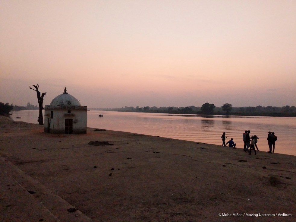
A Betwa sunset
 The Betwa is a silk shawl reflecting the lilac sky at Ranchorji Dham temple on the Madhya Pradesh-Uttar Pradesh border. The temple (unseen) on the banks of the Betwa is a popular spot for pilgrims. Photo Credit: Mohit M. Rao
Farming along the Betwa
 A man aligns pipes that carry with it water being pumped from the Betwa. For farmers in Bundelkhand, the 2019 monsoon was a double-edged sword. On average, every two years, there is a flooding event. This year, most places along the banks have recorded between 3 and 5 flooding events. Urad and Soyabean crop have been washed away, and the state-government assured Rs. 5,000 as compensation is yet to come. However, the increased storage in dams, the raised groundwater levels and the higher flow of the Betwa means that their winter crop of wheat may be a bounty [this is now likely to be spoiled by Covid 19 crisis as we see in early April 2020 when this is published]. For the farmer, life is hard. Uncertainty always looms. Water and the river are vagaries beyond their control. Market prices, availability of pesticide and fertiliser (which has been in shortfall in MP for three years), crop disease, labour availability are man-made factors that dictate how much they can earn. Photo Credit: Mohit M. Rao
When ash falls from the skies
 The massive towers of Bina Thermal power plant are a fixture in the horizon for miles. All around it is a carpet of wheat fed by the Betwa. Villagers say the ash from the plant falls on their fields like light snow. The ash absorbs water and the soil gets harder. For some, a yield of 15 quintals an acre is reduced to 5 quintals now. “We could use a 40-45 HP tractor for tilling. Now, we have to use 60 HP trucks just to till the land,” says Vakil Thakur. Every three years, Prabhu from Hinnod village says he has to hire a tractor-powered plough to loosen the ash-laden soil. “I spend Rs. 10,000 on this. We didn’t have to do this before the plant came up,” he says.
70-year-old Junilal, says the Betwa has changed after effluents of the Thermal power plant and the nearby oil refinery – both of which came in the past 15 years – were released into its waters. ” The river water used to be blue. We used to drink directly from it. Now, the Betwa is murky,” he says. Photo Credit: Mohit M. Rao
Increase in water, decrease in fish
 It is counter-intuitive, but Kemraj, the Kevat community fisherman at Pacchoda, says that more the water in the Betwa, the lesser the fish catch for them. Before the barrage for the refinery was built some 15 years ago on Betwa river for the refinary, large boulders in the Betwa bed would be exposed during non-monsoon seasons and water would flow around it. Now, it stagnates like a large swimming pool. “When water flows, it is easy to set up fish nets between rocks or in the direction of currents. Now, in stagnating water, fish can swim around nets,” he says. Before the barrage, their catch was 50 kg of fish daily. Now, it is barely 4-5 kg. Photo Credit: Mohit M. Rao
This is the last stop. The confluence of Betwa and its tributary Bina. The Betwa flows ever so gently and the confluence is marked with so little fuss. The river was narrower than it was in Orccha, but its distinctive rocks were absent. Betwa flowed like a silk shawl. Tress cling here on the steep banks of the river. A fisherman floats on a tube in the middle of the river looking for fish trapped in his net. The air carries a faint nip of an impending winter night.
A fellowship of slow journalism and observation ends. But the mind races through the memories collected over two weeks and 270 kms. There is not enough time to ruminate and reflect before that day ends. I wanted to etch the scene in my memory, reserve it for posterity because I feared I’d forget its inherent beauty.
Mohit M Rao (mohitmrao@yahoo.co.in)
NOTE: This article has been produced as part of Veditum India Foundation’s Moving Upstream fellowship program. You can read about the program and find more stories here: http://www.veditum.org/moving-upstream/
For further details about Betwa Yatra, see: http://www.veditum.org/upstream/discovering-betwa-and-its-people/
