")
In the Cabinet Reshuffle on Sept 3, 2017, Uma Bharti has been removed as Union Ministry of Water Resources, River Development and Ganga Rejuvenation, for what media is widely calling as her non-performance (http://indiatoday.intoday.in/story/uma-bharti-ganga-experts-cabinet-reshuffle/1/1039555.html).
Unfortunately, some in Media are rather valiantly trying to show that she did achieve something (see for example: http://indianexpress.com/article/india/nitin-gadkari-60-minister-water-resources-river-development-ganga-rejuvenation-ganga-clean-up-the-biggest-challenge-4827277/), when what they are showing only the claims of expenditure or achievement of the ministry, no real achievement on ground based on independent scrutiny or evidence.
Mr Nitin Gadkari has been given the charge of this ministry in addition to his current charge of Ministry of Surface Transport. The first thing that strikes about Mr Gadkari is that as minister in current government he has been strong advocate for use of rivers for inland navigation and he also achieved through an act in Parliament, listing of 111 main stretches of rivers for this purpose. In the initial few months of this government in power, he actually publicly said that he wants to build a barrage every 100 km along Ganga, which he latter said could be done every 50 km. The impact of one existing such barrage on Ganga for navigation, namely Farakka is well known, and it is so severe that MPs and now even Bihar’s current Chief Minister have been demanding decommissioning of the barrage. Indeed, there are huge social and environmental impacts of use of rivers for navigation, but Mr Gadkari’s ministry has been pushing the case that there is no need for even social and environmental impact assessment of the inland navigation plans or activities. Now it will be interesting to see what does Mr Gadkari says about this as Minister of Water Resources, River Development and Ganga Rejuvenation. If past is any guide, it does seem that Ganga, Brahmaputra and other rivers on the list of inland navigation could be in for greater deterioration rather improvement.
Ministry of Water Resources also functions like a lobby for Big dams, big irrigation projects, including interlinking of rivers. Mr Gadkari comes from Maharashtra, which has the distinction of building the largest number of big dams and big irrigation projects, but having one of the least proportion of area under irrigation. It is also a state infamous for India’s biggest irrigation scam of Rs 70000 crores, an issue that contributed hugely in bringing current BJP govt in state to power. However, during the irrigation scam episode, several media stories raised questions about his support for the irrigation contracts or irrigation contractors that were questionable
(e.g. see some examples, there are more: http://www.ndtv.com/india-news/70-000-crore-scam-gadkari-justifies-letter-lobbying-for-controversial-dam-contractors-500930,
Mr Gadkari has also been known to have involvement in sugar mills in Maharashtra (see: http://www.thehindu.com/opinion/op-ed/gadkari-and-the-business-of-politics/article4031763.ece), which are highly questionable considering the water situation in the state.
In August 2016, Mr Gadkari announced that the govt would spend Rs 50000 crores for river front development and navigation (see: http://www.ndtv.com/india-news/government-to-spend-rs-50-000-crore-on-river-front-development-nitin-gadkari-1443446). Considering what river front development has meant for Sabarmati, this can be far from positive sign for rivers.
In Nagpur, where water privatisation attempt, supported by Mr Gadkari has been seen to be a failure, as one media report said the scheme “has been earning more brickbats than bouquets from public and politicians of all hues, including the BJP.” (see: http://indianexpress.com/article/india/nagpur-24-7-water-supply-4686509/)
In Feb 2017, Mr Gadkari proposed what some in media claimed to be a “revolutionary” scheme to build bridge come barrages on rivers (see: http://indiatoday.intoday.in/story/revolutionary-decision-to-build-bridge-cum-barrages-gadkari/1/878230.html), not bothering to understand or assess what this will do to the rivers.
In this background, it will be interesting to see how Mr Gadkari works as Union Minister of Water Resources, River Development and Ganga Rejuvenation.
FLOOD 2017
Op-Ed Radical rethinking of the entire flood-control system required This is excellent report by Samrat that has RIVER as the focus. It also quotes SANDRP extensively.
– KAZIRANGA NEEDS FLOODS Wildlife veterinarian Dr. Panjit Basumatary, who works at the Centre for Wildlife Rehabilitation and Conservation near Kaziranga, agrees that the park needs the floods to survive. “Kaziranga is around 70% wetlands,” he says. “The species here are entirely dependent on water and wetlands.” Without the annual floods, the wetlands would give way to woodlands, and those are not suitable habitats for the rhino, hog deer, swamp deer and other species found in Kaziranga.
– KAZIRANGA WETLANDS BREEDING GROUND OF FISH BIODIVERSITY “The Kaziranga wetlands are breeding ground for all major fish species in the Northeast. They disperse through the Brahmaputra to the whole region during floods,” Basumatary adds. Fish cannot breed in the river’s fast-flowing currents; and blocking their free movement in and out of the wetlands would hamper breeding.
– According to Rohini Saikia, Divisional Forest Officer under whose administrative area the Kaziranga park falls, the annual floods are a “necessary evil”. The survival of the fittest is a law of nature, Saikia points out, and therefore weak and old animals dying of natural causes in the wild should not be considered unnatural. “Kaziranga and its animals have been surviving floods for centuries… the only real cause of concern is animals dying because of vehicles.”
– Kaziranga is bound by the Brahmaputra on one side and the Karbi Hills on the other. Between the park and the hills is a major state highway, the Assam Trunk Road, which cuts off animal corridors. The road is flanked by paddy fields and a number of tea estates.
– ON GOVT PLANS TO BUILD EMBANKMENTS TO SAVE KAZIRANGA: This is despite the fact that embankments have not been particularly effective, even in places other than wetlands, and are likely to harm Kaziranga’s ecosystem. The worst flood damages year after year have occurred either due to embankments breaking or dams releasing water without warning.
– ROLE OF DAMS AND EMBANKMENTS Locals including the district administration officials blamed the sudden release of water from the Ranganadi dam. In the second, current, phase of flooding, 26 embankments have been breached. In one case, in Nagaon district, an embankment inspected and declared safe by the Water Resources Department on August 12 failed that very night.
– Embankments, Himanshu Thakkar says, “are essentially flood transfer mechanisms.” They transfer the floods downstream. “No embankment is breach-proof nor can they flood-proof the area outside of it. Embankments will breach sooner or later. The older the embankment, the greater its chances of breaching.”
– DREDGING BRAHMAPUTRA WILL BENEFIT ONLY THE CONTRACTORS: The government plans to dredge the entire 891 km stretch of the Brahmaputra in Assam, from Sadiya to Dhubri, at an estimated cost of ₹40,000 crore to increase the river’s carrying capacity. Work is expected to begin this winter.
– It is likely that the only lasting positive effect this will have will be in enriching contractors, bureaucrats and politicians. The Brahmaputra has one of the highest sediment loads in the world: it deposits hundreds of millions of tonnes of earth each year. Whatever the government dredges will be filled up by the river in short order.
– NO ONE UNDERSTANDS THE RIVER Hazarika laments that “nobody understands the river.” People, he says, study it in bits and pieces with no holistic understanding. “Someone looks at hydrology, someone else looks at environment, someone else at culture, or people, and so on. Everyone has an idea, but no one consults the local people and communities who have lived there for centuries… you’re trying to bring intervention to an entity you don’t even know.”
– The bottom line is possibly this: we need a radical rethinking of the entire flood-control system we have. One that keeps in mind local socio-environmental features, as well as draws on some of the sound sciences now globally available http://www.thehindu.com/sci-tech/energy-and-environment/understanding-inundation/article19566027.ece
As per another article the Kaziranga flood shows that landscape ecology needs to be privileged over just protected area boundaries. While the park itself is in a low-lying area, wild animals need to move to higher ground. The adjoining and higher Karbi Anglong hills are a traditional dispersal and sheltering area during floods. However, there are a host of growing disturbances between the actual (and well-protected) national park and increasingly disturbed surrounding areas. In the immediate landscape, quarrying permissions have been granted, cars speed and brick kilns have operated. Further, similar to many other protected areas, human settlements are expanding. Not only are animal migration corridors being cut (the animals usually reach Karbi Anglong hills only after crossing a highway), highlands have also been taken over by people. However, unlike in other parks, the issue of ‘encroachment’ is problematised and framed as an illegal, foreign act. https://thewire.in/171864/kaziranga-rhinos-assam-brahmaputra-flood/
Also see, TONGAM RINA ON ETHICS IN MEDIA:
– “In a media industry driven by profit and propaganda, we journalists need to seriously introspect our roles, listen to our inner voice and maintain the objectivity in our reporting, which unfortunately, only a handful of journalists are doing presently.”
– “floods in Assam make front page news in The Arunachal Times only once or twice, and not many times. Media in Assam gives prominent space to environmental threats caused by hydro power projects in Arunachal Pradesh. Mostly, it’s only the ‘downstream impact’ that the media in Assam is interested in.” http://www.assamtribune.com/scripts/detailsnew.asp?id=sep0117/city050
Urban Flooding ABC (Agartala/ Ahmedabad, Bangaluru, Chandigarh/ Chennai) of Urban Flooding this monsoon in India As the writing on the wall is getting clearer for Indian cities, they will need to design their physical and social systems to withstand extreme rain events. This would mean pegging the systems to deal with the intensity, duration and frequency of these events as they are happening in the present. In turn, this will help the cities be climate resilient for the future. http://indiaclimatedialogue.net/2017/08/28/extreme-rainfall-leaves-cities-floundering/
There is another report on Urban floods and how they are worsened by the destruction of wetlands, rivers, lakes. http://indianexpress.com/article/explained/in-fact-many-floods-different-yet-similar-bengaluru-assam-bihar-chennai-srinagar-delhi-gurgaon-4818192/
Mumbai Floods Heaviest rain since 2005 Mumbai faces floods, as predicted several days in advance, but it seems civic bodies were least prepared and citizens even less since civic bodies or media took no steps to make the citizens aware. http://www.ndtv.com/mumbai-news/mumbai-down-under-braces-for-heaviest-rain-since-2005-5-facts-1743294?pfrom=home-lateststories
As per reports, HIGH TIDE at 4.35 could worsen the situation and keep city flooded for many hours. It rained 52 mm in one hour by 12 noon on August 29, 2017. http://indiatoday.intoday.in/story/mumbai-rain-heavy-downpour-next-24-hours/1/1036147.html The live visuals of the floods can be seen here. https://www.thequint.com/india/2017/08/29/mumbai-rains-live
Further an op-ed in on Mumbai floods reads that – “Mumbai’s problem is not angry nature, but bad planning and absence of accountability. A single day of heavy showers – an entirely predictable event in a Mumbai monsoon – bringing the metropolis on its knees underscores poor urban planning and administrative failure in providing long-term solutions.”
– It also highlights key issues like destruction of Mangroves, Mithi river, lakes and drainage system. In a city that has the richest civic body (BMC) with annual budget of Rs 37000 cr. http://blogs.timesofindia.indiatimes.com/toi-editorials/mumbai-sinking-maximum-city-needs-maximum-reboot-to-deal-with-seasonal-showers/
Also see the excerpts from this excellent report that missed one point: There was sufficient advance warning about this particular bout of rainfall, what did the govt, media and others do to reduce the possible damage? https://scroll.in/article/848931/a-state-made-disaster-how-mumbais-civic-body-let-the-rain-swallow-the-city-yet-again
– One could argue precisely the opposite: because the city is a peninsula, hemmed in by the sea on two sides, a proper drainage system would have ensured that water does not accumulate in the very same spots, year after year.
– Drainage networks apart, the city is also blessed with an nature-gifted flood relief system, by virtue of its many rivers and canals. But it was was only in 2005 that the city seemingly woke up to the fact that the Mithi, far from being a filthy drain into the Mahim Bay, was actually a river. It is in fact the overflow from the Tulsi, Vihar and Powai lakes, the first two of which originate in the 110 sq km Sanjay Gandhi National Park – all of which give Mumbai its distinct ecological identity. Mithi River was so badly encroached upon and used as a dumping ground
– The Mumbai municipality is dimly aware, if at all, that there are three other rivers in the city proper – the Poisar, Oshiwara and Dahisar – that course through the megapolis like major arteries and deserve to be kept free of filth to allow storm water to drain freely.
– According to architect and activist PK Das, whose Open Mumbai exhibition in 2013 mapped the entire city, including its slums and open spaces, Mumbai’s major nullahs form a vein-like network that can extend for an astounding 300 km. These could have functioned effectively to drain water out of the city. But this is a natural legacy that the city authorities have abused, with the reckless sanctioning of building after building, in brazen collusion with builders and venal bureaucrats. By indiscriminately dumping waste in open drains, citizens have also contributed to choking them.
– Das has shown by reviving the Irla nullah in the Juhu Vile Parle Development scheme how these can prove both functional in absorbing excess rain as well serve as an excellent site for recreation and cultural activities.
– Ecologically, the city is also blessed with other natural sponges, such as mangroves, wetlands and salt pans, which soak up water and hence prevent flooding. Over the years, many of these have been given away by government authorities to developers to construct supposed affordable housing and the like.
– In June 1985, after a heavy downpour, the Mumbai municipal corporation appointed British consultants Watson Hawksly to prepare a plan that would allow the city to tackle up to 50 mm of rainfall an hour. The consultants took eight year to submit their report and the municipal corporation took another 12 years to implement it. The plan was called the Brihanmumbai Storm Water Drainage report, better known by its tongue-twister of an acronym, BRIMSTOWAD. It proposed, among other things, to install pumping stations to drain the roads and to upgrade the city’s British-era drainage system. While many activists were initially sceptical of the plan, the report is now described as a milestone drainage blueprint for the city.
– the consultants examined the network of existing drains and nullahs more than 1.5 metres wide and divided it into 121 catchments. In a report released this July, on the 12th anniversary of the floods, the Samiti cited how the consultants “studied deficiencies, identified difficulties in cleaning, maintenance, reviewed desilting criteria and prepared a Master Plan for the augmentation of the storm water drainage system”. https://scroll.in/article/848931/a-state-made-disaster-how-mumbais-civic-body-let-the-rain-swallow-the-city-yet-again
Also see, WHO WILL ENSURE WE CHANGE AFTER MUMBAI FLOODS:
– One of these initiatives is being driven by the office of the Principle Scientific Advisor (PSA) to the Prime Minister, R Chidambaram, and involves the implementation of a pilot plan in Chennai. The other is being made by the National Disaster Management Authority and is likely to result in a similar pilot plan for Guwahati.
– One of the objectives of the two initiatives is to develop early warning systems, which will tell civic authorities which areas are likely to be inundated, by how much, and for how long for a particular rainfall forecast.
– The second objective, a more long-term one, is to improve drainage system in the cities, declog existing networks, adopt better solid waste management practices, and regulate new construction in low-lying areas.
WHO WIIL ENSURE THIS HAPPENS: In the roadmap circulated to the state governments, the NDMA has asked the civic authorities to ensure regular cleaning of drains, mapping of water bodies, and creating a system to alert people about heavy rainfall forecasts as short-term measures to deal with flooding. It has also asked them to formulate drainage master plans, remove encroachments and obstructions from natural drainage paths, and carry out topographical surveys of their cities. http://indianexpress.com/article/india/mumbai-rains-chennai-floods-assam-floods-mumbai-floods-strategies-to-tackle-urban-flooding-on-the-table-plans-to-develop-alerts-improve-drainage-4823060/
Another report using satellite maps, shows how Mumbai has destroyed its mangroves and rivers. https://scroll.in/article/849113/mumbairains-satellite-maps-show-how-the-city-killed-its-rivers-and-mangroves-risking-floods
Tamil Nadu Remembering the canals of north Madras Op-ed by Nityanand Jayaraman Pooja Kumar on the boom ranging impact of encroachment of canals and water bodies in Chennai. A full-fledged network of canals used to drive commerce in north Madras in the days of yore. Today, however, it remains misty in the minds of the fishing community and has vanished from public memory. Chennai continues to encroach on these valuable channels, endangering the city in times of floods. Perhaps, the December 2015 floods will teach us some lessons, in this 378th year of the founding of this city. http://www.thehindu.com/news/cities/chennai/a-venice-that-no-longer-is-remembering-the-canals-of-north-madras/article19577538.ece
Study FORESTS CAN HELP REDUCE FLOODS Key findings of the study conducted by IIT Kharagpur are……..
– “The study findings indicate that for a majority of states, the presence of forest cover tends to protect human lives and reduce the adverse consequences of floods significantly.
– “For Madhya Pradesh, despite increasing forest cover, flood damage has increased.” this could be due to the area claimed under forest cover being plantations and also huge deforestation that has been going on.
– Bihar registers the highest average number of lives lost and people affected (246.07 and 777,7357.14, respectively). It has an average forest cover of 7,425.64 sq. km (0.08 per cent of its geographical area) http://www.business-standard.com/article/news-ians/indian-states-with-high-forest-cover-likely-to-better-cope-with-flood-damage-experts-117082400356_1.html
Another research, though about three US Coastal cities, is equally valid for coastal Indian cities like Mumbai, Chennai, Kolkata and other cities like Surat also facing coastal influences. It shows there are three compounding impacts: High Rainfall in the city, the river flooding and impact of high tide and rarely all three are properly accounted for. There is a fourth factor that needs to be accounted for: possible impact of releases from upstream dam or breach of embankment or disaster at other water bodies. https://www.washingtonpost.com/news/energy-environment/wp/2017/08/29/hurricane-harvey-shows-how-we-underestimate-flooding-risks-in-coastal-cities-scientists-say/?utm_term=.978c46f99eaf
MONSOON 2017
National Amid normal monsoon claim, dip in reservoirs level The report has some interesting analysis showing how Met Dept’s average of normal monsoon is far from normal in reality. https://scroll.in/article/848410/met-department-says-monsoon-is-going-well-but-reservoirs-across-india-tell-a-different-story
Maharashtra BAD MONSOON IN VIDARBHA COULD MEAN POWER CRISIS IN SUMMER? Vidarbha (Nagpur, Chandrapur, Wardha, among other districts) has such a bad rainfall and water storage situation that farmers are suffering (this article does not even mention that), urban and thermal power plant water requirements is so bleak that thermal power plants are seeing need to shut down and there is fear of power crisis in summer. http://timesofindia.indiatimes.com/city/nagpur/power-cuts-loom-over-state-next-summer/articleshow/60298232.cms
HYDRO POWER
Centre Generation up, installed capacity down THERE IS BIT OF SPIN HERE: While in absolute terms, hydro generation did grow by 2.22% from 15083 MU in July 2016 to 15418 MU in July 2017, the installed capacity grew from 42897 MW in July 2016 to 44614 MW in July 2017. So in terms of MU generated per MW installed capacity, there was a 1.7% REDUCTION in July 2017 compared to July 2016. This is another evidence of diminishing returns from big hydro. http://energy.economictimes.indiatimes.com/news/power/hydro-generation-grew-2-14-per-cent-in-july-as-reservoir-storage-levels-dip-to-51-per-cent/60298920
Mizoram 1st 30 MW unit of 60 MW TUIRIAL HEP commissioned The cost of the project is at Rs 1100 crores (from initial Rs 369 Cr), which means MW installed capacity is MASSIVE, over Rs 18 Cr. What is the cost of electricity from such a project and how is it viable?
– Farmers’ protests, agitations, topographical hindrance and administrative hurdles delayed the commissioning of the project
– However, soon after project work started, farmers and locals launched a series of agitations against the submerging of their standing crops and farmland under the reservoir.
– Bora, who is the project head, said work came to a total halt on June 9, 2004, due to the agitation launched by the “abruptly-formed Tuirial Crop Compensation Claimant Association, claiming compensation for the standing crops in the riverine reserve forest”.
– According to the company’s senior engineer, work resumed in 2011 after the Union Power Ministry, NEEPCO and the Mizoram government jointly negotiated with the agitators. http://energy.economictimes.indiatimes.com/news/power/mizoram-becomes-third-power-surplus-state-in-the-north-east/60322370
Manipur Demand to decommission Lthai dam getting louder The call to scrap Ithai Dam intensifies as locals of Thanga protested urging the state govt to decommission the dam. The local fishing community along with other activists echoed that Ithai dam is more a “curse” rather than bringing development. A community meet on merits and demerits of 105 mw Loktak Project was held at Thanga, Haorang Chingya on 02 Sept 2017. The meet was organized by Citizens Concern for Dams and Development, North East Dialogue Forum, Centre for Research and Advocacy Manipur, Committee on Human Rights, Irabot Foudation, United Clubs of Thanga, All Thanga Meira Paibi Apunba Organization, Loktak Project Affected Areas Action Committee and Loktak Fisheries Welfare Association. http://www.ifp.co.in/item/3320-decommission-dam-cry-gets-shriller
Himachal Pradesh Govt mulls change in hydro policy CM and govt accept that Hydropower is in slow down mode, the suggestions that financial incentives will help is misleading. http://www.tribuneindia.com/news/himachal/virbhadra-for-change-in-hydropower-policy/460723.html
DAMS
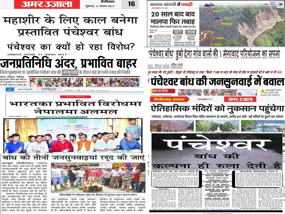
SANDRP Blog Loud Media Message: Public hearing of Pancheshwar Dam is illegal Bhim Singh Rawat of SANDRP has compiled the huge number of media stories before, during and after the Pancheshwar public hearingin Uttarakhand on Aug 9, 11 and 17. They provide an overview of the illegalities involved in the Public Hearing, EIA and Pancheshwar Project itsefl and drive home the point why they are not going to be acceptable or legally tenable. https://sandrp.wordpress.com/2017/08/30/loud-media-message-public-hearing-of-pancheshwar-dam-is-illegal/
MoWR CWC signs MoUs with NIT Calicut and NIT Rourkela Central Water Commission (CWC) has signed MoUs with NIT Calicut and NIT Rourkela to support dam rehabilitation efforts of various implementing agencies and CWC under Dam Rehabilitation and Improvement Project (DRIP) project with World Bank assistance. DRIP is assisting rehabilitation of 225 dams in seven States which are experiencing different levels of distress. This is interesting initiative, but what we need more than anything is transparent dam management, that is also participatory and accountable. http://pib.nic.in/newsite/PrintRelease.aspx?relid=170344
India ranks third globally with 5254 large dams in operation and 447 large dams under construction. About 4% of these large dams (209) are over 100 years old and about 17% (876 dams) are more than 50 years old. Many of these dams are facing varying degrees of inadequacies in meeting the current standards of dam health and safety due to various reasons. The second PIB next day states that DRIP is facilitating the rehabilitation of about 198 large dam projects in 7 States whereas preceding day PIB release claimed the number to be 225. http://pib.nic.in/newsite/PrintRelease.aspx?relid=170394
Maharashtra Reservoir operation schedule norm violated, again The basics norms related to reservoir operation schedule of dams located in upstream areas of Jayakwadi major irrigation project have been allegedly violated this year as well, making different parts of Marathwada prone to both water scarcity and floods. As per farmer leader Jayaji Suryawanshi, majority of 22 dams located in Ahmednagar and Nashik districts had started releasing water only after live storage was almost exceeded that is considered as violation of laid down norms. http://timesofindia.indiatimes.com/city/aurangabad/reservoir-operation-schedule-norm-violated-again/articleshow/60314802.cms
INTERLINKING OF RIVERS
SANDRP Blog REUTER’s biased, misleading, erroneous reporting about Ken Betwa Project Detailed article about how MISLEADING, BIASED and FACTUAALLY incorrect is the Reuters Report on Ken Betwa Project on Sept 1, 2017. Plz Share and hlep us spread the word. https://sandrp.wordpress.com/2017/09/02/reuters-biased-misleading-erroneous-reporting-about-ken-betwa-project/
Indeed, REUTERS PUBLISHES FACTUALLY INCORRECT REPORT ON KEN BETWA PROJECT. This is such a non sense, factually incorrect report. http://in.reuters.com/article/india-rivers/modis-87-billion-river-linking-gamble-set-to-take-off-as-floods-hit-india-idINKCN1BC4SF
Similarly, it is surprising to find this interview of Sharad Jain on India Water Portal and have posted following by way of comment on its website.
The interview is not even referring to the serious problems that Dr Sharad Jain is creating in India’s water governance. It is important to highlight them since they are hugely contrary to what he is saying here or the impression he is giving here. Just two illustrate two of them.
- He is involved in conflict of interest issue, being chairman of MoEF’s Expert Appraisal Committee on River Valley Projects and also being Director General of NWDA, see details below: https://sandrp.wordpress.com/2017/05/30/open-letter-to-moef-remove-chairman-of-expert-appraisal-committee-on-dams-for-conflict-of-interest-he-is-dg-of-nwda/
- The EAC that he chairs actually cleared the most controversial Ken Betwa River Link project in its very first meeting, when earlier five meetings of the EAC did not clear it and the issues that the earlier EAC raised remained unresolved, and in fact the project does not have even credible EIA and public hearings involved huge violations and were in complete in any case. See links below by way of illustration only.
By publishing this interview without raising these basic issues, the IWP is giving him an opportunity to greenwash or give an image contrary to his actions. One does not expect that from IWP. http://www.indiawaterportal.org/articles/recycling-answer-indias-water-woes
Similarly this TOI report is again factually wrong when it says the project has all the clearances. However, it reveals some details of interstate water sharing dispute:
– MP Govt had dug up a 40-year-old agreement — signed during the Shyama Charan Shukla government — to say that the deal was to give only 1,200 million cubic metre (MCM) water to UP.
UP demands 2,200 MCM water from Ken river- “Earlier, UP signed an MoU with the MP government for taking 1,700 MCM water from Ken River, but now they demand 2,200 MCM, which is not feasible. MP has to quench the thirst of a huge population in Bundelkhand region besides irrigating around 4.5 lakh hectares of land. So much of water cannot be shared with UP. Their demand is uncalled for,” said a senior officer of MP. http://timesofindia.indiatimes.com/city/bhopal/uma-bhartis-tweet-reveals-row-over-ken-betwa-river-linkage-project/articleshow/60313477.cms
Meanwhile Veditum also highlights the factually wrong reporting by Media about Ken Betwa and ILR. http://veditum.org/fact-check/tragedy-errors-ken-betwa-river-linking-project/
IRRIGATION
Telangana State ignoring minor irrigation projects As per the report successive governments have failed to realise the importance of harvesting water at local level which has high chances of success besides being advantageous in many other ways. Local projects should indeed be the top priority and till their potential is exhausted, there should be no larger projects, when unfortunately, the situation is opposite today.
– While the medium irrigation dam constitutes harnessing of the enormous quantities of run off water, successive governments have failed to realise the importance of harvesting water at local level which has high chances of success besides being advantageous in many other ways.
– Though Kadem reservoir, now in Nirmal district, receives a marvellous 2.5 lakh cusecs calculated as the maximum flood discharge, much of its vast catchment area of 2,590 sq km spread over western Adilabad district continues to face water shortage during summer season.
– WHEN AN ENGINEER DOES NOT WANT TO BE NAMED FOR LISTING BENEFITS OF LOCAL PROJECTS: “There would be less of environmental destruction owing to smaller structures. Land required for such structures will be on a much reduced scale thereby eliminating the issues inherent to land acquisition for projects, observed an irrigation engineer, not wanting to be quoted, as he pointed out the benefits of minor irrigation tanks and watersheds.
– “In Adilabad district alone, proposals for construction of over 50 MI tanks with an ayacut of about 10,000 acres are gathering dust,” the engineering official lamented. “These tanks can bring great changes in the lifestyle of local population,” he added.
– The Pradhan Mantri Sinchai Yojana also remains a non starter in Adilabad thanks to the government being busy with the major projects. There is hardly any allocation from the Central government under this scheme.
Maharashtra Bombay HC flays govt for delay in irrigation scam inquiry Coming down heavily on the State Govt, Nagpur bench of Bombay High Court on August 28, 2017, orally flayed it for unnecessarily delaying the probe into Rs 70,000 crore scam in irrigation projects. One hopes the court will continue to push the govt, else there is no hope for any worthwhile progress here. http://timesofindia.indiatimes.com/city/nagpur/court-flays-govt-for-delay-in-irri-scam-inquiry/articleshow/60266119.cms
RIVERS
SANDRP Blog Nominations for BPS-2017 & Shri Anupam Mishra Memorial Medal-2017 Invited This is to request for nominations for Bhagirath Prayaas Samman (BPS) 2017. As you will recall BPS is an attempt to acknowledge and celebrate outstanding, inspirational, unsung initiatives in river conservation. This year we are also initiating Shri Anupam Mishra Memorial Medal to celebrate media professionals who have established an exceptional body of credible work on various aspects of rivers leading to changes in behaviour, public discourse, law and policy. https://sandrp.wordpress.com/2017/08/31/nominations-for-bps-2017-shri-anupam-mishra-memorial-medal-2017-invited/
Maharashtra IGATPURI WASTE DUMPED IN MUMBAI WATER SUPPLY RIVER As per the report piles of garbage, including medical waste, are being illegally deposited into a tributary of Vaitarna which is a part of the network of rivers that supplies water to Mumbai — in Igatpuri.
– The water from Vaitarna River and its garbage-tainted tributary reaches the Middle Vaitarna Dam near Kasara. Excess water from the dam is regularly transferred to the Modak Sagar and Tansa dams. The three reservoirs collectively supply 300 million gallons of water to Mumbai daily.
– After Mirror drew the attention of the Maharashtra Pollution Control Board, its member secretary, N Anbalagan, asked the Nashik regional officer to order an urgent inspection. “We will issue them instructions for closure (of the illegal dumping zone) soon,” Anbalagan said. https://mumbaimirror.indiatimes.com/mumbai/crime/bmc-protests-as-garbage-chucked-by-igatpuri-municipal-council-taints-mumbais-water-supply/articleshow/60252412.cms
In a separate development, the Bombay HC on 01 Sept. 2017 directed the State Govt, BMC and the MPCB to reply within two weeks over the concerns raised in a PIL on untreated sewage being let into the sea and Mithi River.
– The court has asked state and civic authorities to file an affidavit within two weeks on the complaints raised in a PIL that has sought direction from the court in order to frame guidelines to stop the pollution of coastal waters of the city,
– The PIL has been filed by a NGO, Citizen Circle for Social Welfare and Education, through advocate Syed Shehzad Abbas Naqvi.
GLOBAL PRACTICE VS MUMBAI MISDEEDS: The petitioners say they have personally surveyed the coastal areas of Mumbai city and were “shocked, surprised and dismayed to notice that there are several points along the coastline of Marine Drive where they found sewage discharged through big sewage pipes directly into the Arabian Sea at the coastline itself whereas it is the duty of BMC to discharge sewage at a distance of about 3.7km from [the] coastline, which is practised worldwide.” http://gulfnews.com/news/asia/india/concerns-over-polluted-coastline-raised-in-court-1.2083546
WATER
NITI Aayog bats for water conservation, groundwater banking
NITI Aayog in its three-year action agenda for 2017-20 published on 24 August has suggested some interesting measures.
– “A feasibility study should be conducted for assessing groundwater banking potential in India by 2018. Some clear advantages of groundwater banking are low fixed costs as compared to dam and reservoir construction, no requirement for rehabilitation and resettlement and less environmental changes,” the three-year plan noted.
– The three-year plan also suggested measures such as state-specific water policies including an independent regulator with powers to regulate water uses and pricing, enactment of legislation for protection of water bodies and prevention of encroachment on water bodies, enactment of river basin management law and formation of River Basin Organizations (RBOs) for management of inter-State river basins by 2019 and enactment of a National Water Framework Act. http://www.livemint.com/Politics/oiaNH25ERXPpe7Ng65P9tN/NITI-Aayog-bats-for-water-conservation-groundwater-banking.html
DELHI WATER
CGWB report about Delhi Groundwater situation Some excerpts from the report
-In its report called “Hydrogeological Framework and Groundwater Management Plan of NCT Delhi,” released recently, CGWB has recommended extraction in Zone 1 areas, where groundwater is available at a depth of less than 8 metres below the ground. However, the report also said that many areas in this zone had poor quality water and this should be used for salt-tolerant crops or blended with clean water for non-drinking purposes.
-The board said extraction projects should not be allowed in areas with declining water level (zone III). These included Delhi Cantonment, Vasant Vihar, Hauz Khas, Kalkaji, Chanakyapuri, Connaught Place, Punjabi Bagh, Paharganj, Preet Vihar and Vivek Vihar. CGWB has said if pumping continued at the current rate here, it would result in saline water. It has recommended rainwater harvesting and use of tertiary treated waste water for recharge of these areas.
-The report warned that overexploitation was not only depleting water resources, but turning groundwater saline. Of the 13,491 million cubic metres (MCM) of groundwater in Delhi, 10284 MCM, or 76%, was brackish or saline.
– As for places abutting the Najafgarh drain, the report stated that the “presence of heavy metals has been reported in groundwater along the drain. Therefore, groundwater in this zone is unsuitable for drinking and irrigation purposes…pesticides and bacteriological parameters have also been reported in isolated pockets. It is recommended that landfill sites should be selected after concluding hydrogeological surveys to minimise the risk of groundwater pollution”.
-CGWB has identified a “potential aquifer zone” along the western Yamuna canal which can yield around 5 million gallons per day (MGD) of water (the city’s need is estimated to be 1,140 MGD by the 12th Five Year Approach Plan paper). The board also mapped tehsil-wise groundwater level trends between 2003 and 2013. http://timesofindia.indiatimes.com/city/delhi/check-here-if-groundwater-in-your-part-of-city-is-safe-for-use/articleshow/60283065.cms
SOUTH ASIA
Nepal Media report post Nepal PM’s Aug 2017 visit to India Mr. Deuba apparently failed to convince New Delhi that more than a dozen embankments India “unilaterally” built on its side of the border cause floods in the Madhes area every year and need immediate “review” and “correction”. All that Delhi said was there will be more “consultation and cooperation”. http://indianexpress.com/article/opinion/columns/nepal-elections-politics-sher-bahadur-deuba-slipping-in-delhi-4816604/
Another interesting statement in Nepal media about what Nepal PM conveyed to India is that in the meeting, PM Deuba urged the Indian side not to stop the natural flow of water by means of dams while in case of construction of any structure in the border area, consent of the Nepali side is a must. Both sides agreed to set up a high-level panel to find a durable solution to floods. http://kathmandupost.ekantipur.com/news/2017-08-25/india-hails-local-polls-wishes-for-statute-implementation.html
Bhutan Govt sets up Hydropower Committee Acknowledging the importance of hydropower sector and bilateral relations with India, the Cabinet issued an executive order on May 15 establishing a hydropower committee with a mandate to develop a clear, robust, and consistent policy that will be driven by the overall long-term interest of the country.
The chief executive officer (CEO) of Druk Holding and Investments (DHI), Dasho Karma Yezer Raydi, is the chairperson of the committee. Members include Dasho Chhewang Rinzin, CEO of Druk Green Power Corporation, Dasho Yeshey Wangdi, secretary of economic affairs ministry, GNHC secretary Thinley Namgyel, and Karma Yonten from His Majesty’s Secretariat.
The committee is also given the task to draw a hydropower strategy in the immediate and medium terms.
SOUTH EAST ASIA
Myanmar DISTRIBUTED HYDROPOWER? This article by a water energy development company representative, makes a plea for distributed Hydropower projects in Mynmar, rather than the 50 MEGA projects with cumulative capacity in excess of 40 000 MW. But such projects will also need full social and environmental impacts assessment, cumulative impact assessment, as also process to achieve social acceptance through democratic decision making. https://www.mmtimes.com/news/rethinking-hydropower-myanmar.html
CHINA
Wrong media reports claiming China hand behind floods in Bihar and UP This is so shocking allegation by ill informed Indian Media. The barrages (Kosi, Gandak, Sharada) on the rivers that flow from Nepal to India are controlled by Indian engineers. They in any case do not have big capacity to store. http://www.livehindustan.com/uttar-pradesh/story-nepal-was-leaving-water-on-the-behest-of-china-from-the-barrages-1383698.html
Similarly, China’s water bomb theory should not be given too much importance, there are several inaccuracies. However, this is only to take note that such stuff is also being published. http://topyaps.com/china-water-bomb-india
THE REST OF THE WORLD
DAM FLOODS IN US Houston dam spills over for 1st time in history, overwhelmed by Harvey rainfall Early Monday morning (28 August 2017) , the U.S. Army Corps of Engineers began releasing water from two Houston dams (Addicks and Barker reservoirs) because water levels in their reservoirs were rising more than half a foot per hour, the result of extreme rainfall from Harvey.
– Officials said thousands of homes along the reservoirs could be affected, and by midmorning Monday, streets and houses in some surrounding neighborhoods had already begun flooding, ABC 13 News reported.
– To complicate any evacuation efforts, several major roadways that run through both reservoirs are underwater, including portions of State Highway 6, Barker-Cypress Road, Clay Road and Westheimer Parkway. Officials expect those routes to remain impassable for “several weeks to several months.” https://www.washingtonpost.com/news/post-nation/wp/2017/08/28/houston-releases-water-from-two-dams-in-attempt-to-prevent-uncontrolled-overflow/?utm_term=.d6dfa1b07fcb
FLOODING due to Harvey Hurricane in Texas NOW has led to fear of explosion in chemical factory, people in 1.5 mile radius have been evacuated. As many observers say, WE STILL DO NOT KNOW WHAT ALL HARVEY HAS DONE. https://www.nbcnews.com/storyline/hurricane-harvey/harvey-danger-major-chemical-plant-near-houston-likely-explode-facility-n797581
According to another report Superfund sites polluted by Harvey threaten to contaminate floodwaters https://www.washingtonpost.com/news/energy-environment/wp/2017/08/29/houstons-flood-threatens-to-turn-polluted-superfund-sites-into-a-toxic-gumbo/?utm_term=.7943964457c9
Meanwhile, the scope of the devastation caused by the hurricane came into sharper focusand the murky green floodwaters from the record-breaking, 4-foot deluge of rain began yielding up bodies as predicted. The confirmed death toll climbed to 23. Authorities are investigating at least 17 more deaths to determine whether they were storm-related. http://abc7chicago.com/weather/houston-flooding-forecast-brings-hope-as-new-shelters-open-death-toll-rises/2357520/
As per another report, Houston reservoirs faced 100 year floods in consecutive years: 2016 and now 2017:
– This is the second year in a row that severe floodwaters have tested Addicks and Barker. Just last year, during 2016’s so-called Tax Day Flood, for the first time, the reservoirs hit and surpassed the level of a 100-year flood. That happened again this weekend, meaning the dams have seen two extremely rare flood events (at least one-in-a-100-year events) in just as many years. Last year was also the first time the National Weather Service ever issued a flood warning for the Addicks and Barker watersheds.
– Houston is also guilty of destroying flood absorption capacity: They were built in a region of water-absorbing prairie grasses that have in recent years been paved over by water-impermeable parking lots, driveways and suburban streets. The Sierra Club even sued the Corps in a failed attempt to stop construction on a nearby stretch of the Grand Parkway, a major toll road project that some opposed fearing it would coax development in an area that’s critical to the region’s flood control efforts. https://www.texasobserver.org/dams-meant-to-save-houston-from-extreme-floods-pushed-to-the-limit-twice-in-2-years/
There is one more report suggesting role of dams in worsening the Houston floods.
– “The controlled release from Addicks and Barker started late Sunday night, but the reservoir levels were still rising. On top of that, water was already spilling over the sides of Addicks in an “uncontrolled release” and Barker was expected to soon follow suit, as we reported.”
– “Still, it’s not over yet and the increase of water from Addicks and Barker is showing up in neighborhoods near the dams and along Buffalo Bayou. Roads running through the reservoirs are also underwater and are expected to remain submerged for weeks to come. And considering there’s still runoff streaming down from the sections of Harris County and other counties above the reservoirs, the pool levels at both Barker and Addicks may continue to rise, even though the reservoir outlet gates are open.” http://www.houstonpress.com/news/more-homes-flood-thanks-to-the-addicks-reservoir-and-buffalo-bayou-9749088
There is another interesting report about how the decision to build reservoirs was taken after the 1935 Houston floods. https://www.wired.com/story/houston-dams-probable-maximum-flood-vs-500-year-flood/
Also see, very interesting narrative of earlier Houston floods of 1929 and 1936 https://www.washingtonpost.com/news/retropolis/wp/2017/08/30/houstons-besieged-dams-compromised-by-harvey-rainfall-were-built-70-years-ago-after-devastating-floods/?utm_term=.ad549b991a94
One more report says that Houston experienced 100 year flood in 2016 and now 500 year flood in 2017. https://www.nytimes.com/interactive/2017/08/28/climate/500-year-flood-hurricane-harvey-houston.html?mcubz=1
This is true that Hurricane Harvey is set to be one of the most devastating natural disasters in American history.
By 29 August 2017 it had dumped about 56.8 BCM of water over Houston and was likely to dump about 93.4 BCM by the time its done. Hurricane Katrina, in comparison, dumped about 24.6 BCM. So Harvey has ALREADY dumped 2.31 times the water Katrina dumped and is likely to dump about 3.8 times the Katrina water by the time its done.
– “Here’s another scary comparison: Harvey is dumping about 65 percent of the volume of the Dead Sea on Houston. It is enough to destroy a city, and make no mistake, that’s exactly what it’s doing. Even the emergency dams designed to handle such flooding are themselves overflowing, and the authorities are running out of options.”
– The storage capacity of India’s biggest reservoir, Indira Sagar Dam in Madhya Pradesh, is 9.745 BCM, so Harvey has ALREADY dumped, in just about six days, water of six such reservoirs and may dump 3-3.5 more such reservoirs before its done! http://www.iflscience.com/environment/how-much-water-hurricane-harvey-dumping-houston/
REALLY WE CANNOT ENGINEER YOUR WAY OUT OF FLOODING:
– “Houston is the reminder that you cannot engineer your way out of flooding.”
– lood control officials in Houston say Hurricane Harvey has caused at least a 500-year flood, meaning it beat the 0.2 percent odds of that much rain falling at one time. Nearly 52 inches dumped on Houston in four days, according to the National Weather Service. That’s the most ever recorded for a single storm in the continental U.S.
– Much of the Central Valley still lacks 100-year-flood protection, and many of the rural areas have levees that are only rated for 50-year floods, said Joe Countryman, a retired U.S. Army Corps engineer who sits on the Central Valley Flood Protection Board.
– After Hurricane Katrina, the Legislature in 2007 ordered California’s urban areas to be protected from a 200-year flood. …but they’re still years away from completion.
– A 2015 federal study declared California’s risk of catastrophic flooding worse than any other region in the country – even the southern hurricane states. The reason? The huge storms called atmospheric rivers that often strike California in the winter.
– “I think we did amazingly well this last winter, given it was the wettest year on record for Northern California and particularly given the problems at Oroville, but it is easily possible to have worse storms,” said Jay Lund, executive director of the Center for Watershed Sciences at UC Davis.
– “All those improvements don’t eliminate flooding,” Mount said. “They just make it less frequent.” http://www.sacbee.com/news/state/california/water-and-drought/article170234577.html
As per recent news report Hurricane Harvey has submerged port Arthur: – City officials said much of Port Arthur — a city of 55,000 — was under water. A shelter for flood victims flooded. One official estimated that water had entered one-third of the city’s buildings. https://www.washingtonpost.com/news/post-nation/wp/2017/08/30/harvey-again-makes-landfall-this-time-as-a-tropical-storm-near-cameron-la/?utm_term=.bed2e3acc43f
Also see, HOW WILL HOUSTON DRAIN ALL THAT (57-94 BCM) WATER? https://www.scientificamerican.com/article/hurricane-harvey-houston-has-no-quick-way-to-get-rid-of-floodwater1/
Study Global assessment of food and storm extremes with increased temperatures The significant research findings are:– The cost of annual global food damages was estimated at over $50 billion in 2013 alone.
– THIS FINDING IS COUNTER INTUITIVE? There is little observational evidence that flood magnitudes have increased. In fact, observational records present more evidence for a decrease in annual flood maxima, despite increases in precipitation being well documented
– Trough a range of analyses we find that stream flow-temperature sensitivity is largely negative while precipitation-temperature sensitivity is positive, implying that while rising temperatures lead to an increase in the incident precipitation, a decrease in the stream flow is observed, except in the rarest of cases or when catchments are small (defined as those with catchment less than 1000 sq km). https://www.nature.com/articles/s41598-017-08481-1.pdf
ENVIRONMENT
National Do you want to shut down NGT, Delhi HC asks Centre Acting Chief Justice Gita Mittal and Justice C Hari Shankar of Delhi High on 25 August 2017 has expressed concern over the posts of judicial and expert members in the NGT falling vacant shortly, and sought a report from the govt. This is yet another way the govt is trying to shut down NGT, as even Delhi High Court asks. http://energy.economictimes.indiatimes.com/news/renewable/do-you-want-to-shut-down-ngt-delhi-high-court-asks-centre/60235447
SANDRP BLOG SITE JUST NOW CROSSED A MILLION HITS FIGURE.
This part of SANDRP Journey, the BLOG, started about five years ago and we are happy that within five years we have crossed million hits mark.
Congratulations to everyone at SANDRP since this is totally a team effort. Thanks are particularly due to Parineeta Dandekar who initiated the blog.
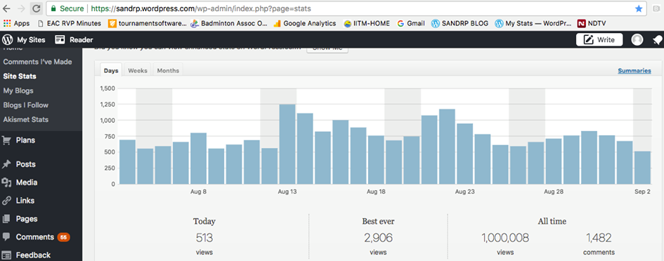
We are also thankful to thousands of SANDRP followers on blog, FB, Twitter and other ways. We are also thankful to all those have written for our blog and helped us in so many ways to make this possible. We are also thankful to all our supporters who have supported us materially and so many ways.
THANK YOU ALL, WE WILL CONTINUE TO NEED YOUR SUPPORT.
SANDRP TEAM.
You may also like to see DRP 28 August 2017 & DRP 21 August 2017
