About Kerala Rivers
Of Kerala‘s 44 rivers, 41 flow westwards and the rest towards east. The basin area of major rivers is located within the Western Ghats, a global biodiversity hotspot, while some other northern rivers originate in laterite hills. The short length of the rivers coupled with very high population density (over 30 million people living in a land area of 38,000 sq km) creates high dependency on water and the rivers‘ susceptibility towards environmental onslaughts.
In the six major rivers featured in the Status Report, we discuss biodiversity in riparian upper catchments and low lying wetlands. Overall, the southern Western Ghats region with catchments including many of the major riers of Kerala, Karnataka and Tamil Nadu has the highest freshwater species richness (260–312 species) and endemism (103–129 species), with particularly unique diversity of fish in Chalakudy and Periyar rivers. In rivers like Bharatapuzha, of the 6000 odd sq km catchment, a mere 100 sq km has intact forests in the catchment of Kunthipuzha, the lifeline of the river‘s summer flows. The Vembanad-Kol wetland, the largest estuarine system in India, is fed by 10 rivers. It supports diverse livelihoods – below sea level paddy farming, fishing, coir retting, to name a few. The wetlands offer flood protection for thickly-populated coastal areas and contributes to groundwater recharge.

Our rivers are under pressure from anthropogenic activities. Water scarcity in many parts of the State can be attributed to high rain water runoff and loss of forest cover in the upper catchments, and more directly to sand mining and reclamation of wetlands and paddy fields. Conversion of watershed area, including large scale deforestation and plantation crops, has altered the hydrological regime and enhanced the silt movement – lowering water yield in the catchment affecting the groundwater recharge and summer flow in rivers with some of the perennial rivers and rivulets becoming seasonal in the last few decades. The State‘s forests are under threat of de-notification for development and expansion schemes to promote recreational and religious tourism related activities in the upper catchments of Chalakudy and Pamba rivers, respectively. Even with the Sand Mining Regulatory Act (2001) in place, mindless sand mining continues in all of Kerala‘s rivers.
Pollution continues to grow despite river conservation organizations raising alerts. In Pamba river, for instance, glaring pollution impacts are felt from unregulated pilgrim activity. Health issues related to toxic pollution in the Eloor – Edayar stretch of Periyar river have been repeatedly seen reported, pushing Periyar into the Red List we have prepared.
Dams in Kerala have submerged vast stretches of indigenous domains and forests. River flows of Periyar, Chalakudy, Bharatapuzha, Siruvani and Neyyar have been diverted for inter-state and inter-basin diversions.

Kerala has 12 major hydroelectric projects and a few small hydropower projects. The total installed capacity of the major schemes, including their extensions, is 1968.75 MW and that of SHPs is 107.4 MW. In Parambikulam, Sholayar, Mullaperiyar and Idukki dams, the river does not flow for long before being joined by the next tributary or recharge from the catchment.
Emerging threats include the Athirappilly HE Project, the Pooyamkutty and Pathrakkadavu HEPs that have not been officially abandoned by the Government of Kerala and the KSEBL. The Pandiyar-Punnampuzha HEP and the NW-3 or the 205 km long West Coast Canal are two other farfetched proposals. The Pamba Achenkovil Vaipar Link (PAVLP) envisages diverting 634 mcm of water from these two rivers to the water- deficit Vaipar basin: the three PAVLP dams would submerge 1,398 ha of virgin forests and heavily alter Vemabnad‘s ecology.
Of the eastward flowing rivers, we feature Kabini. The protection of the 1920 sq km of its catchment is crucial to restore flows in the Cauvery basin. Smaller rivers in Kerala like those originating from laterite hills in northern Kerala such as Kariangode and Kavvayi face pressures from laterite mining in the hillocks, real estate and monoculture plantations of cashew and rubber, affecting the recharge into the laterite hills. Karamana, the main artery of Trivandrum city, is under the threat of pollution, encroachment and sand mining. Except for Vamanapuram, flow in all the southern Kerala rivers is regulated by dams.
The river bank culture is closely intertwined in Kerala as a large part of the population is settled near a river, canal or backwaters. The historical and cultural narrative we present traces the early civilizations, wars and trade links, pioneer development initiatives during the British times and traditional farming practices in Kerala, apart from cultural aspects such as temple festivals, boat races and folk rituals.
We recommend that the six rivers discussed at length in this report – Chaliyar, Bharatapuzha, Chalakudy, Periyar, Pamba, Kabini – be considered as Red Listed, on the basis of the issues concerning them. This is not to discount issues faced by other rivers but to help concerted efforts in effective river restoration. The Government has shown interest in the idea of legally constituting River Basin Authorities/ organizations for better management. Planning for the entire river basin must be totally decentralised bottom – up planning and implementation process. We recommend a revival strategy for degraded rivers.
A report by Manju Vasudevan
Notes:-
- This report was commissioned for India Rivers Week 2016.
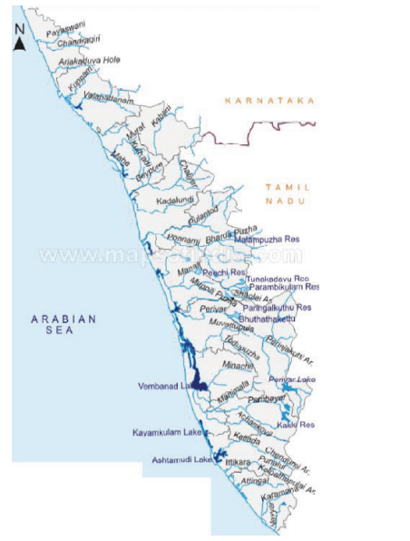
- The Kerala Drainage map has been put together by a WWF Team led by G Areendran, the names of the rivers have been provided by an INTACH Team led by Dr. Manu Bhatnagar.
- The names in bracket represent the Key tributaries; RED color is for (Critical) status; BLUE is for (Safe) status and rest are PINK (Threatened) status.
- Its a short description, for detail report kindly explore the link Kerala Rivers Profile
- You may also like to see rivers profiles for Rajasthan, West Bengal, North-East India, Maharashtra , Haryana, Uttarakhand , Himachal Pradesh States
- The same report can also be seen on India Rivers Week Blog

Attempts are seen to kill the Athirappally water falls and chalakudy river in Trichur
LikeLike
Very interesting and helpful
LikeLike