
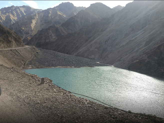
Above: Landslide Dam over Sonam River in Uttarkashi Dist in Uttarakhand (Photo from Jagran.com)
A landslide on Sonam river (Bhagirathi basin) in Bhatwari block in Uttarakashi district in Uttarakhand has blocked the flow of the river and created a lake about 90 m long, 80 m wide and 1.5-3 m deep. The landslide dam in Nelong valley in Jadhganga river basin about 145 km from Uttarkashi town, apparently was formed due to landslide during cloud burst on July 27, 2016, but the information about it reached the administration only on Sept 4, 2016, 39 days later. The landslide dam, about 24 km from the India China border has created a threat to the downstream river bank communities, roads and bridges and other structures and also ecology. The reservoir has been formed at the confluence of Angar Nallah, a local stream, with Sonam River. A team of officials sent by the District Collector on Sept 5, 2016 has submitted a report, but the report is not yet in public domain.
Media Reports: In English media, The Tribune[i] and The Hindu[ii] reported on Sept 6 and Sept 7, 2016 respectively about the landslide dam at Tripani. It was reported that due to reduction of water flow in downstream river, fish were dying. The landslide dam is a threat to not only the people but also bridges, roads and other structures. The Hindu quoted the Sub Divisional Magistrate that the lake formation started in 2009, but how come the lake survived so many years and what happened in 2012 (see the information below) is not explained. It also reported that the authorities have declared the lake harmless (assuming that the rainy season is over), but it is not cleared what is the basis of this declaration. The officials have also ordered widening of the water outlet from the lake.
Earlier Hindi newspaper Jagran[iii] reported on Sept 5, 2016 that the landslide dam created on Sonam river due to a large section of a hill falling into the river, is threatening a large section of population in Bhatwadi block in Uttarkashi district. The lake size was reportedly increasing as the landslide is also active. Some tourists and ITBP jawans informed the authorities about the landslide. Next day, Jagran reported[iv] that the river was dammed on July 27, following a cloud burst event leading to landslide. Then the size of the lake was much smaller and the newspaper criticized the government for not realizing about the existence of the lake for 39 days and allowed it to grow in size. The report quoted the district magistrate (DM) accepting the delay in getting the information. He said the administration got to know about it only on Sept 4 from LIU (Local Information Unit), and immediately the DM formed a 60-member group to visit the spot on Sept 5 to take stock of the situation. The team included personnel from district and state disaster management authority, forest department, Gangotri National Park, Irrigation Department, Central Public Works Department, SDRF (State Disaster Rescue Force), Sub Divisional Magistrate, among others. DM said there is not need to panic, but it is important to start draining of water from the lake. ITBP officer was quoted as agreeing that the lake was formed on July 27. A Border Road Organisation (BRO) officer was quoted as saying that some baily bridges of BRO were also damaged in the floods on July 27.
Another report on Sept 8, 2016 showed that there were differences between the administration and BRO about the threat due to the landslide dam. While administration is saying that the the lake is not such a threat and that BRO is only creating different perception to hide its own inabilities.
The altitude here is around 4000 m in barren, grassland and shrub land habitat, and WWF-India has reported[v] siting of snow leopard in 2008. Tourism pressure is one of the major threats in the area. Incidentally, the NBWL (National Board of Wild Life) Standing Committee[vi] cleared construction of Border post by ITBP using 0.6 ha of Gangotri National Partk at Tripani in 2014.
There have in fact been several instances of major landslides in the area in 2016 monsoon. For example, a video[vii] featuring a landslide along the Gangotri Highway appeared in news media on Sept 1, 2016, the massive landslide led to 15 hour blocking of the Highway. Another such landslide video[viii] again on the same Gangotri Highway was flashed by news channels on July 23, 2016.
Threat The landslide dam is a threat[ix] to the Sonam Camp of ITBP (just 4 km downstream from the dam), bridge connecting with Jadung Camp, Naga Bridge, Naga Camp, BRO bridge being constructed along Nelang river. The Dam is a threat to Dharali, Harshil, Bagori, Jhala villages in Gangotri Valley, and also other villages along the bank of the river. In 1978, breach of similar landslide reservoir on the same Bhagirathi river led to extensive damage in Bhatwari, Maneri, Gangori tehsils. Four years back in a similar incident, Jagran reports[x], at the same location, a reservoir was created due to landslide, but in the rapid flow of the river, it got washed away, it is not clear if there were damages in that episode.
No official information No information about this threatening landslide so far is available on on Uttarakhand DMMC (Disaster Mitigation and Management Centre) (http://dmmc.uk.gov.in/), NRSC National Remote Sensing Centre (http://www.nrsc.gov.in/), Uttarkashi district website (http://uttarkashi.nic.in/), Uttarakhand govt website (http://uk.gov.in/), or the National Disaster Management Authority websites. We hope this situation quickly changes and all relevant information and action plans are put in public domain.
SANDRP (ht.sandrp@gmail.com)
END NOTES:
[i] http://www.tribuneindia.com/news/uttarakhand/lake-formation-imperils-uttarkashi-residents/290809.html
[ii] http://www.thehindu.com/news/national/lake-formed-by-rain-threatens-bro-bridges/article9077816.ece
[iii] http://www.jagran.com/uttarakhand/uttarkashi-lake-made-in-sonam-river-at-uttarkashi-14638616.html
[iv] http://www.jagran.com/uttarakhand/uttarkashi-lake-made-in-sonam-river-at-uttarkashi-14645263.html
[v] http://awsassets.wwfindia.org/downloads/snow_leopard_conservation_in_uttarakhand_and_himachal_pradesh.pdf
[vi] http://www.moef.nic.in/sites/default/files/FINAL%20MINUTES.pdf
[vii] https://www.youtube.com/watch?v=C1Sx-qIi_8k&feature=youtu.be
[viii] https://youtu.be/FK6g4IlH7j0
[ix] http://www.jagran.com/uttarakhand/uttarkashi-14643656.html#sthash.cyiPfcA3.dpuf
[x] http://www.jagran.com/uttarakhand/uttarkashi-14643590.html#sthash.9Vql2xaG.dpuf

This has happened even as the state and central governments are stupidly planning to push a major highway (supposedly for defence purposes) into one of the last most pristine valleys in Uttarakhand and perhaps the entire country. Admission into this valley I think is restricted even today.
State officials are busy greedily marking trees to be cut down for the highway in the Bhagirathi Eco-Sensitive Zone. Defence purposes my foot, they are going to revive all the stalled dam projects.
LikeLiked by 1 person