The year 2013 was an important for the water sector of northeastern states of India with several significant events. In this article I have tried to summarize some of the important events, issues and concerns of the water sector in northeast.
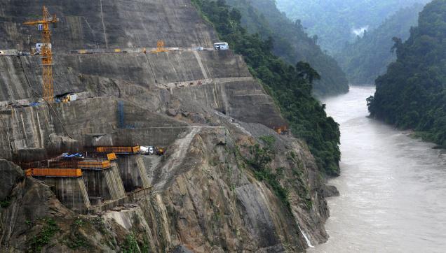
Massive hydropower projects considered and cleared for northeast An analysis done by SANDRP for the year 2013 has showed that massive hydropower capacity in northeast India has been considered and cleared by Expert Appraisal Committee (EAC) on River valley and Hydroelectric projects. The total installed capacity of considered by EAC for the year 2013 is 29458 MW and out of which 21805 MW (over 74% of 29458 MW) projects are in the northeast India. On the other hand out of the total capacity considered for northeast, 20180 MW (over 92.5% of 21805 MW) projects are in Arunachal Pradesh. The total number of projects considered from northeast for 2013 was 37, all (including the Dibang multipurpose project, which is basically a hydro project) are hydropower projects. Out of these 37 projects, 10 projects of 4917 MW installed capacity has been given TOR (Terms of Reference) clearance or the Stage 1 clearance. 4 projects with 953 MW installed capacity has been given final environment clearances. 13 projects with 9078 MW capacity had been given extension of their TOR validity which implies that in next 2-3 years all these projects would also come up for final environmental clearance.

Photo – Parag Jyoti Saikia
India-China Water Information Sharing MoU of October 2013 One of the most important developments of the year 2013 was the signing of this Memorandum of Understanding through which it was agreed that the current hydrological data (Water Level, Discharge and Rainfall) in respect of three stations, namely, Nugesha, Yangcun and Nuxia located on river Yaluzangbu/Brahmaputra from 1st June to 15th October every year will now be extended to May 15th to Oct 15th with effect from 2014. Another important news through this agreement is that the Government of India recognizes the value of river since the agreement writes “rivers and related natural resources and the environment are assets of immense value to the socio-economic development.” But this agreement has been misread and misreported by a large section of the media. SANDRP wrote a detailed blog “Media Hype Vs Reality: India-China Water Information Sharing MoU of Oct 2013” which clears the fog around this agreement. The blog also lists formation and decisions of the meetings of the Expert Level Mechanisms (ELM) on Trans-border rivers and MoUs on Hydrological Data Sharing on River Brahmaputra / Yaluzangbu and Satluj / Langquin Zangbu.
Forest Clearance Rejected for Tipaimukh and Dibang Hydropower Projects In the year 2013 the rejection of forest clearance to 1500 MW Tipaimukh hydropower project and 3000 MW Dibang multipurpose project by the Forest Advisory Committee (FAC) of MoEF is noteworthy. Here it should be noted that the Prime Minister of India laid foundation stone for the Dibang Project in Jan 2008 when the project did not have any of the statutory clearances! However, NHPC has already started lobbying the Prime Minister headed Cabinet Committee on Investments to intervene for the forest clearance for Dibang Project and a note has already been moved for this. We hope these FAC decisions are not reversed as it happened in case of Kalu dam in Maharashtra, where the FAC decision was reversed following a letter from the Chief Minister. The stay over the construction work of Maphithel dam in Manipur by the National Green Tribunal could have been regarded as a positive sign but recent reports suggests that Union Ministry for Tribal Affairs (MOTA) had done a U-turn by going “back on its views to say that the Forest Rights Act should not apply to the acquisition of land from the Tanghkul and Kuki tribal people as a ‘rare and unique’ exception.”[1]
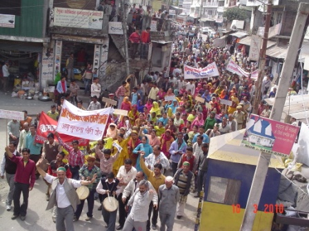
Two years of Anti-dam protests in Assam and Tripartite Talks The protest against large hydropower dams in Arunachal Pradesh had reached a new milestone as the stoppage of construction work of Lower Suabansiri hydropower project completed two year on 16th December 2013. This stoppage of the construction work of the Lower Subansiri project has brought the issue of downstream impacts of large dams to the forefront and also showed how a mass movement can question a top-down development project. These protests were led by Krishak Mukti Sangram Samiti (KMSS), All Assam Student Union (AASU), Asom Jatiyatabadi Yuba-Chatra Parishad(AJYCP) along with several other organizations.

On Dec 6, 2013, a tripartite discussion was held involving the central government, Government of Assam and experts protesting organizations. Though this meeting failed to come to a common resolution, it led to the expert to expert meeting on the Lower Subansiri dam issues on 22nd December 2013.
These discussions not only help in building public opinion about the issue but also provide platform to discuss the larger issues related with 168 hydropower dam proposed for Arunachal Pradesh and its cumulative impacts in the larger Brahmaputra basin.
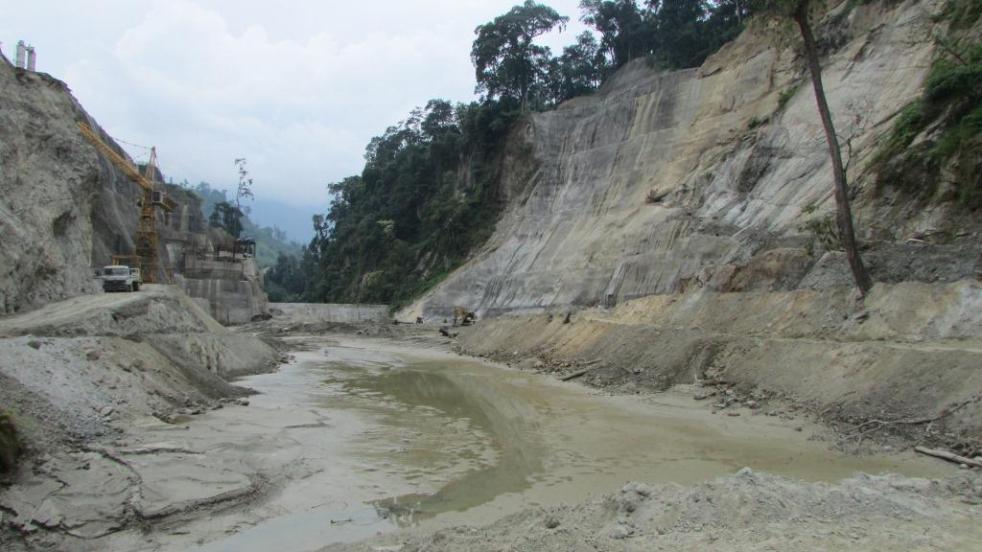
Foreign Funding of Hydropower projects in Northeast In the year 2013 Asian Development Bank has agreed to give loan of $ 200 million to construct the Lower Kopili Hydropower project in Karbi Anglong and Dima Hasao districts Assam. This project is being constructed by Assam Power Generation Corporation Limited (APGCL) and it is 8 km downstream of Kopili hydropower project, first dam on Kopili river. It is important to note that acidic contamination of water due to unabated mining in the upstream Meghalaya is a poses a major threat for the viability of the dam and this was disclosed in a study initiated by the project proponent. This project was given TOR clearance in the 69th meeting of EAC.

Photo – Parag Jyoti Saikia
Foreign funding of hydropower project comes with the risk of huge cost overruns. This was evident in the case of Pare HEP on Pare/Dikrong river which NEEPCO constructing taking a loan of 80 million euros from KfW, a German Bank. Incidentally, this project was schedule to be completed in September 2013 but Central Electricity Authority status report on projects under execution now states the completion time as 2015. The cost of this project has already increased by 205% from its initial estimates. The loan amount along with the interest rest is also increasing year by year and NEEPCO’s 36th Annual Report of 2011-12 states that the loan taken from KfW is “repayable in 30 equal half yearly installments w.e.f. 30.12.2013.” This implies that even before the completion of the project the company has to start paying back the loan.
SANDRP had written a detail blog titled “Lower Kopili HEP: Oustanding issues that must be resolved before EAC can consider the project” which discussed the issues related with the proposed dam including the increase in intensity of floods in downstream Nagaon.
Assam’s Flood Devastation For Assam, the central state of northeast India, flood is an annual event. In the year 2013 Assam witnessed three waves of flood. The table below provides a glimpse of the extent of the flood disaster Assam faced in 2013. The data is sourced from National Disaster Management Institute under the Ministry of Home Affairs of Government of India.
Data from NDMI, Government of India
| Months | No of affected People | No. of affected districts | No of affected Villages |
| 30th June |
14649 |
4 |
70 |
| 31st July |
7971 |
4 |
55 |
| 31st Aug |
6123 |
3 |
73 |
| 16th Sept |
6123 |
3 |
73 |
But it was surprising to find that the numbers of affected people and villages provided by a central government organization is much less than the number provided by the disaster management department of the state government. The State Disaster Management Authority of Assam (SDMAA) provides much larger number of affected people. During the monsoon months of 2013, SDMAA published daily flood report on its website. After following the flood reports of four months, the following table with some key dates has been prepared to give an idea of the discrepancy between state government and central government data.
Data from SDMAA, Government of Assam
| Months | No of People affected | No. of districts affected | No of Villages affected |
| 30th June |
22,696 |
7 |
125 |
| 16th July |
31,174 |
4 |
107 |
| 31st July |
7716 |
4 |
45 |
| 10th August |
53,714 |
4 |
164 |
| 15th August |
33,563 |
5 |
102 |
| 24th August |
6123 |
3 |
73 |
| 31st August |
10,851 |
4 |
70 |
| 2nd September |
2714 |
3 |
55 |
| 6th September |
1,45,054 |
8 |
411 |
| 7th September |
3,24,531 |
14 |
572 |
| 10th September |
3,54,731 |
13 |
534 |
| 16th September |
2510 |
2 |
16 |
This discrepancy points towards the lack of the coordination between the state and the central government departments which is clearly not good sign. Floods need serious attention and such misreporting can lead to confusions which will ultimately have bearing on the people of Assam. It is important to mention that many in Assam believe that the problem of flood in Assam has not been dealt adequately by the central government. The discrepancy detailed above reinforces that belief.
False claim about climate induced displacement in Northeast India by a global agency In connection with the flood issue, the year 2013 will also be marked by the publication of the report named “Global Estimates 2012 – People Displaced by Disasters” by Internal Displacement Monitoring Centre (IDMC) based in Geneva, Switzerland. This report had stated that the largest climate induced displacement in the world for the year 2012 happened in two states of Northeast India, Assam and Arunachal Pradesh in June 2012 due to the monsoon floods which displaced 6.9 million people, constituting about 21.2% of the population of the two states. But a detailed analysis of this report by SANDPR revealed that the though these figure are highly exaggerated. This analysis is available at “2012 Floods Displaced 6.9 Million in Northeast-IDMC: Staggering but Highly Exaggerated”.
Havoc of Erosion In Assam, along with annual floods, river bank erosion by Brahmaputra and its tributaries is a major cause of concern. The year 2013 is also no exception and severe erosion was reported in several parts of the state. A report Study of Brahmaputra River Erosion and Its Control done by IIT Roorkee, published in 2012 measured the loss of land due to erosion of Brahmaputra for nearly two decades in twelve reaches of the river. The total loss of land on both sides of the river Brahmaputra is mentioned below.
|
North Bank |
South Bank |
||||
| Total Erosion Length (km) | 1990 to 2007 – 08 (in sq. km) | 1997 to 2007-08 (in sq. km) | Total Erosion Length (in km) | 1990 to 2007 – 08 (in sq. km) | 1997 to 2007-08 (in sq. km) |
| 353.85 | 538.805 | 327.726 | 389.13 | 914.62 | 730.8 |
This report, sponsored by National Disaster Management Authority (NDMA), was a very descriptive report from the point of information and data about the river Brahmaputra and its tributaries. But an analysis of the report done by SANDRP, found that this report was biased towards structural interventions and hydropower projects and oversimplifies the problem of erosion by identifying ‘sediment overloading’ as the main reason for erosion. This analysis can be found at “NDMA Commissioned IIT Roorkee Study on Brahmaputra River Erosion: A Biased and Structural Solution Oriented Report?”.

Photo: Asomiya Pratidin
The year 2013 also witnessed people in river-rine areas of Assam demanding relief from erosion. On May 21st 2013, the people of Bahgara Dhunaguri village panchayat in the Lakhimpur district of Assam floated the effigy of State Water Resources Minister Rajib Lochan Pegu in a traditional raft in the Subansiri River in Dhunaguri Baduli Para area. The TMPK units of Dikrong Awanori and East Dikrong joined in this protest. According to the beliefs of Mishing society when someone dies due to unnatural causes, his/her body is floated in a traditional raft in flowing river. People accused that Mr. Pegu had completely failed to perform his duty as a water resource minister and he had not been able to give any relief to the people by preventing flood and erosion. Failing to perform his duty has been regarded as the ‘unnatural death’ of the minister & that was why people floated the effigy of the minster.[2]
With respect to construction and repair of embankments, some serious issues were brought to light in the year 2013. In May 2013, All Assam Water Resources Contractors’ Association revealed that out of the total embankment length of 4473.82 km in Assam, the government had repaired only 1327 km embankment, leaving 3673 km long embankment completely vulnerable to floods.
Parag Jyoti Saikia (meandering1800@gmail.com)
with inputs from Himanshu Thakkar
——————
In the year 2013, SANDRP has written 13 blogs on issues related to North East India. A list of those blogs is given below. SANDRP has also made continuous submissions on dams and basin studies from Northeast to EAC and those submissions are available in our website https://sandrp.in/.
- NDMA Commissioned IIT Roorkee Study on Brahmaputra River Erosion: A Biased and Structural Solution Oriented Report?
- 2012 Floods Displaced 6.9 Million in Northeast-IDMC: Staggering but Highly Exaggerated
- Review of “Water Conflicts in Northeast India – A Compendium of Case Studies”: A Welcome Initiative
- CWC Flood Forecast for Assam: Issues Started Arriving before Floods
- Brahmaputra – The Beautiful River or The Battleground?
- IWMI report on Glaciers and Snow cover in Himalayas in Changing Climate: Significant Impact on Seasonal flow of the Rivers in India
- Lower Kopili HEP: Oustanding issues that must be resolved before EAC can consider the project
- Subansiri Basin Study – Another Chapter of Environment Subversion in Northeast
- Climate Change, Migration and Conflicts in Assam-Bangladesh: Why we need better reports than this
- Hydro Power Projects Violating SC order in the Greenest State of India
- When EIAs Don’t Know River Lengths! Review of EIA/EMP of Simang I & II HEP on Simang River in Arunachal Pradesh
- Media Hype Vs Reality: India-China Water Information Sharing MoU of Oct 2013
- Comments on Scoping Clearance Application of Panyor HEP on Ranganadi River in Arunachal Pradesh
[1] http://www.thehindu.com/news/national/other-states/ministry-uturn-may-clear-hurdles-for-manipur-project/article5550604.ece
[2] Dainik Janambhumi, Guwahti, “Brahmaputra, Subanshirir Khohoniya Tras” 22nd May, 2013


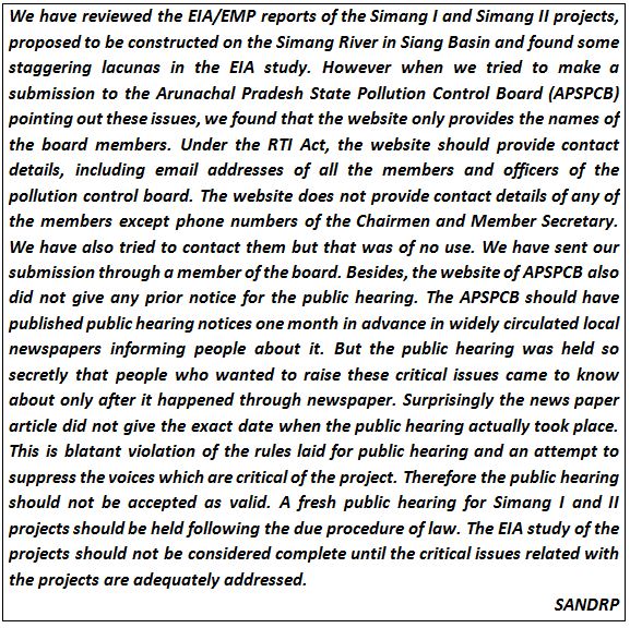 The Simang River is a tributary of the Siang River which originates at an elevation of 2950 m. The river is 44 km long (as mentioned in the EIA/EMP reports done by consultant R S Environ Link). Total catchment area of Simang River is 554 sq km. There are two projects proposed on the Simang River. The first one is Simang I with an installed capacity of 67 MW (3 x 22.33 MW) and catchment area of 494 sq km. The second one is the upstream project Simang II with an installed capacity of 66 MW (3 x 22 MW) and catchment area of 422 sq km. These two projects were jointly discussed in the 19th meeting of EAC in October 2008 for the first time. Then these projects were subsequently discussed in the 21st, 36th, 66th and 67th meeting of EAC. A diagram of the two projects on the Simang River is given below.
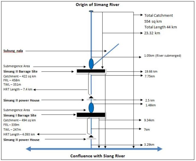


 Agreement), reduced the water availability in 2013 summer to less than 1 MCM per day resulting in severe water stress in the river basin. On top of the water shortage, intra-day as well as inter-day flow fluctuations in tail-race discharge from PLB HEP had worsened the situation. Anticipating water shortage the river basin MLAs as well as Local Self Government (LSG) heads had been demanding action from the State Government since December 2012.
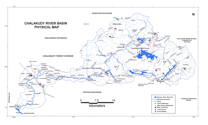
 healthy flow even during summer months. However, at present, the natural summer flow in the river has reduced drastically due to forest degradation and dams and diversions. Consequently, the present river flow in non-monsoon months is almost entirely dependent on the storage at Kerala Sholayar and Poringalkuthu reservoirs. The downstream major irrigation project, the Chalakudy River Diversion Scheme (CRDS) does not have storage of its own. It is completely dependent on the tailrace discharge from the PLB – HEP. Over the last two decades, the daily flow fluctuation due to the semi-peaking operation of the PLB-HEP is affecting the functioning of CRDS. Incidentally, the campaign against the proposed Athirappilly hydroelectric project (AHEP) had first brought this issue into focus. One of the major issues with regards to AHEP, a peaking power station, was the downstream impacts of drastic intra-day flow fluctuation (to the tune of 1:17).

 readily accepted the proposed ROM strategy. Many LSGs demanded the state government to implement this, through resolutions. With the shortage in rainfall during 2012 monsoons, severe water stress was anticipated and a series of steps were taken to put pressure on the state government for dams re-operation so that the summer water shortage for downstream areas can be reduced.
 The Study The study has been done by IRG Systems South Asia Private Limited (