After August 14, 2021 landslide dam[i] on Chenab river in Himachal Pradesh, there have been two more such incidents in north west Himalayan region of Uttarakhand and Ladakh.
Harkot artificial lake
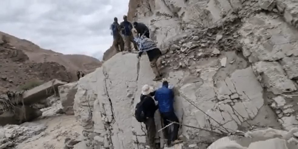
The first incident occurred around 11:30 am on August 21 2021, downhill Harkot village, in Munsyari, Pithoragarh after a part of steep hill detached close to confluence of Ritha and Harkot streams.

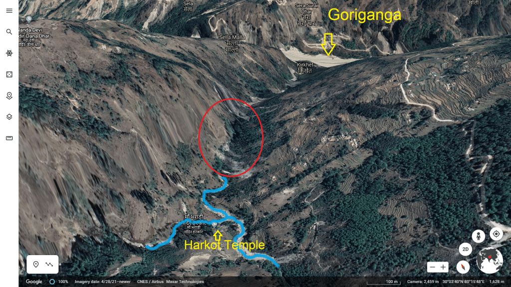
The debris, boulders blocked[ii] the channel known as Bharadi gaad probably after merging of Harkot and Ritha branches, creating an artificial lake. Gaad is local term attributed to streams prone to flash floods in hilly areas.
The size[iii] of lake is mentioned to be 300 metre long and 10 metre high at the altitude of 7000 feet. The incident created flash flood threat to about 3000 population living in downstream areas.

Bharadi gaad is tributary of Goriganga river. The entire about two and half km long stretch of the stream seems prone to landslips. Several scars of past landslips can be seen along its course.

Local reports mention flash flood threats to low lying areas for about five villages namely Madkot, Bhadeli, Rumalkhet, Malupati, Gorichal. Google Earth 3D satellite image shows Charkham, Kirkhet two villages along Bharadi stream. The Madkot is local market town on left bank of Gauri Ganga and Malupati is located slightly uphill opposite Madkot on right bank of Goriganga. Both locations are approximately 6 km downstream the artificial lake.
For a couple of days before the artificial lake was formed, the area received heavy rainfall. A team of revenue official having paid a visit[iv] to the area was supposed to submit report by August 23, charting out future course of action.
Malupati and Bhadeli villages in the area are disaster prone[v] where landslip incidents are expected. On May 22, the heavy rains damaged[vi] the bailey bridge on Munsiyari-Madkot road at Saithal. The bridge was built on May 5, 2021, after it was washed away in flash floods in 2020. There have been similar incidents of flash floods, cloud bursts and landslides in the area causing destruction in recent past.
Claiming water level in lake declining gradually, the administration said there is less chance of breach or flash flood. Local people also admitted lake level going down but felt that the threat remained.
Rumbak GLOF

In the second[vii] incident, the artificial lake formed in Union Territory of Ladakh breached[viii] creating flash flood in downstream areas. The event seems unfolding around midnight hours of August 21 and 22 in Rumbak village area under Leh district.
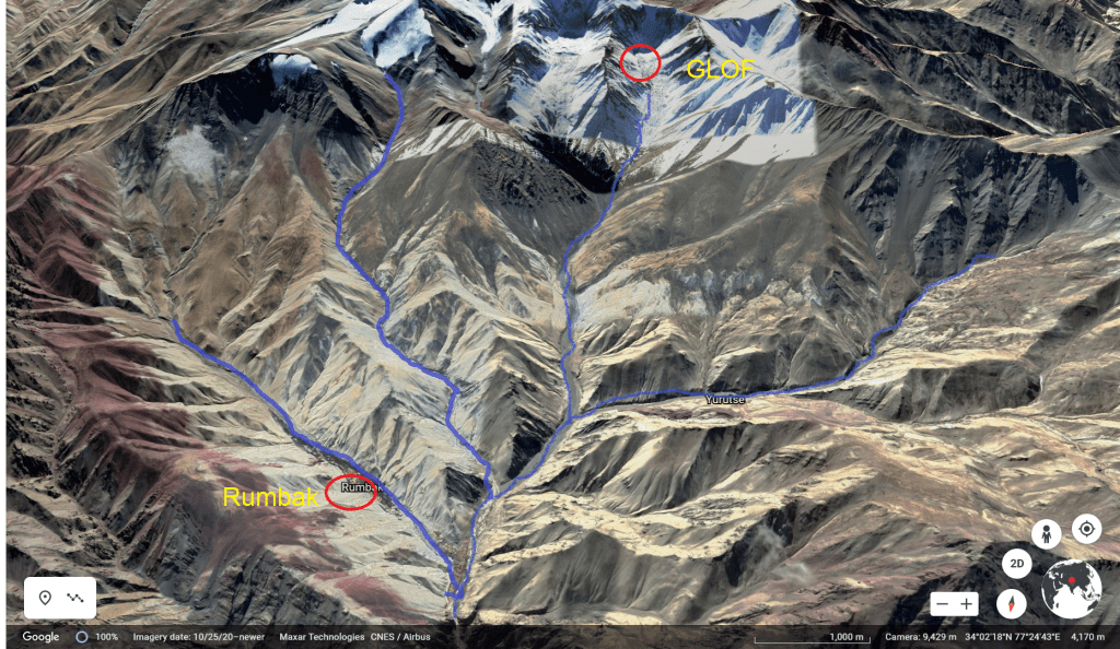
As per information, a glacier lake had formed[ix] on a mountain peak upstream of Rumbak. There is no information available when the lake was formed but the Department of Information and Public Relations, Leh made glacial lake outburst flood (GLOF) alert[x] at 08:21 pm on August 21 through its official tweeter handle @DIPR_Leh.
The DIPR, Leh also mentioned that the GLOF caused flash flood has blocked Indus river thus creating ANOTHER ARTIFICIAL LAKE waiting to burst anytime.
In the tweet made at 09:03 pm, DIPR, Leh also posted a 47 second long video[xi] showing glacial lake breach and text reading: “The road approaching Rumbak, Zingchen, Yurutse and Rumchung has been cut off from the main road.”
Irfan Rashid, Assistant Professor, Department of Geo-informatics, University of Kashmir has managed to secure before and after imageries[xii] of the glacier lake though Planet lab showing the lake filled with water on August 18 and dewatered area on August 24. According to Rashid the geo-coordinates of the lake is 33°59’50″N, 77°25’21″E at an elevation of about 5268 metre which is around 7 km uphill Rumbak.
The devastation around Rumbak seems to have taken place four or five hours after the official information was made public. There has been no casualty reported, however the flash flood has washed away[xiii] 5 culverts, 5 water mills, head works of many irrigation channels (khuls), damaging Rumbak bridge, crops over 20-30 kanals farmland and several trees. The flood deluge has also damaged 4 roads[xiv] around Rumbak.
15 visitors from Spituk village who were struck in Hot Spring Water Therapy were rescued by locals & administration. A short video[xv] displays the flood impact on Rumbak village. An image[xvi] of the artificial lake can be seen.
After an air recce, the district administration reportedly have confirmed[xvii] that the deluge in Rumbak was a result of GOLF. The Rumbak, Jingchen, Yuruse, Rumchung villages are disconnected from road services. The entire administration including UT DRF, Army and ITBP have reached[xviii] the area to help people move to safe places.
In the wake of second artificial lake, the District Disaster Management Authority (DDMA) issued[xix] an alert on August 22 evening asking senior officers including chief engineer National Hydro Power Corporation (NHPC) Nemoo Bazgo Project, SDMs of Liker and Khaltsi and Ladakh disaster response force to stay alert[xx] and prepared for flooding in the Indus river. The population living downstream Nemoo was also asked to stay prepared[xxi] for flooding in the river.

Nimoo Bazgo[xxii] is NHPC’s 45 MW (3X15) hydropower project near Alchi village on Indus River in Nimoo which is Leh district headquarter. All 3 units of the HEP were commissioned in 2012-13. The power station area falls in Zone-IV of seismic zoning map of India, which means its highly seismically active area.

The river distance between GLOF on Zanskar till it joins Indus is about 18 km. The Nimoo Bazgo project is some 35km further downstream from Zanskar-Indus confluence. Roughly the distance between GLOF location to Nimmo could be around 55-60 km.
The Deputy Commissioner, Leh though its official twitter handle (DC_Leh_Official) made a tweet thread[xxiii] at 01.58 PM on August 22 posting images, videos showing officials reaching out to affected villagers, scale of damages. One video in series shows JCB working to restore flow in Indus river.
DIPR, Leh has also tweeted[xxiv] a video, some images at 05:10 pm on August 22, mentioning that district officials and rescue team have visited Rumbak area to take stock of situation and provide essential services. So far there is no update available on the latest status of second artificial lake. Most reports quote officials stating situation to be being monitoring and under control.
It is well known that the Himalayan region is geologically fragile and climatically sensitive. In recent time and over past few months, there has been sharp increase in landslides, cloud bursts, flash floods incidents across the hill states. However, the remote sensing monitoring which became focal point after February 7, Chamoli disaster, remains limited to discussion only.
In Lahul Spiti and Pithoragarh incidents local were first to alert the district administration and in Ladakh case, administration could inform only about outburst and seems clueless on its formation or when it was formed. The devastation around Rumbak suggests possible lack of adequate preparedness and mitigation despite information made public hours before the flash flood.
The GLOF uphill Rumbak caused formation of one more artificial lake downstream, showing that these are real emerging threats. The exact location of second artificial lake is still unknown. We are waiting for more clear satellite images by experts explaining both events with exact locations, impacts and would update the post accordingly.
Bhim Singh Rawat (bhim.sandrp@gmail.com)
POST SCRIPT:–
As per August 19, 24 and Oct. 31 satellite images shared on November 1, 2021 by Irfan Rashid, Assistant Professor, Department of Geo-informatics, University of Kashmir show considerable part of Indus flow channel blocked by moraine debris of Zanskar river post Aug. 22, Rumbak GLOF event. The pondage behind moraine dam has been rising posing as potential flash flood threat in case of sudden breach or earthquake in the area.
Irfan Rashid tweeted: “This alarming situation cloud prove dangerous in case of an earthquake hits the area and when spring melt peaks up and river flows remains dammed after winter.”
Responding to SANDRP alert Sharad Chandra, Director Central Water Commission (CWC) asked NRSC for imagery analysis. The latest update henceforth is awaited.
Also see: Landslide dam on Chenab river in Himachal Pradesh
References:
[i] https://sandrp.in/2021/08/14/landslide-dam-on-chenab-river-in-himachal-pradesh/
[ii] https://www.jagran.com/uttarakhand/nainital-lake-formed-by-breaking-the-mountain-in-munsiyari-21948273.html
[iii] https://www.livehindustan.com/international/india-abroad-news/story-lake-become-after-rivers-flow-stop-munsiyari-pithoragarh-himani-nadiyan-disaster-uttarakhand-4407361.html
[iv] https://timesofindia.indiatimes.com/city/dehradun/300-m-long-artificial-lake-forms-at-7k-ft-sparks-fear-of-flash-floods/articleshow/85542377.cms
[v] https://www.amarujala.com/uttarakhand/pithoragarh/the-lake-formed-in-bharadigad-due-to-the-breaking-of-the-rock-three-villages-are-in-danger-pithoragarh-news-hld435308149
[vi] https://timesofindia.indiatimes.com/city/dehradun/bridge-damaged-in-rains-weeks-after-it-was-built/articleshow/82865296.cms
[vii] https://www.greaterkashmir.com/todays-paper/front-page/artificial-lake-bursts-in-ladakh
[viii] http://brighterkashmir.com/bridge-crops-damaged-as-artificial-lake-triggers-flash-floods-in-ladakh
[ix] https://www.dailyexcelsior.com/lake-burst-leads-to-flash-floods-in-leh-village/
[x] https://twitter.com/DIPR_Leh/status/1429095038026338304?s=20
[xi] https://twitter.com/DIPR_Leh/status/1429104405974945796?s=20
[xii] https://twitter.com/irfansalroo/status/1430610014780067847?s=20
[xiii] https://www.dailyexcelsior.com/lake-burst-leads-to-flash-floods-in-leh-village/
[xiv] https://www.amarujala.com/jammu/an-artificial-lake-create-in-ladakh-s-zanskar-river-leh
[xv] https://www.bhaskar.com/national/news/flash-flood-in-village-of-ladakh-damage-to-bridge-and-standing-crop-officials-had-already-issued-alert-regarding-flood-128841752.html
[xvi] https://m.jagran.com/lite/jammu-and-kashmir/jammu-flood-in-many-villages-link-roads-cut-due-to-artificial-lake-burst-in-ladakh-21950524.html
[xvii] https://www.dailyexcelsior.com/lake-burst-leads-to-flash-floods-in-leh-village/
[xviii] https://www.thestatesman.com/india/red-alert-sounded-in-villages-along-ladakhs-zanskar-river-following-outburst-of-artificial-lake-1502997436.html
[xix] https://www.indiatimes.com/news/india/flash-floods-due-to-outburst-of-artificial-lake-damage-bridge-crops-in-ladakh-547748.html
[xx] https://indianexpress.com/article/india/bridge-standing-crops-damaged-in-flash-floods-in-ladakh-7465261/
[xxi] https://www.greaterkashmir.com/ladakh/bridge-standing-crops-damaged-as-artificial-lake-triggers-flash-floods-in-ladakh
[xxii] http://www.nhpcindia.com/Default.aspx?id=186&lg=eng&CatId=1&ProjectId=39
[xxiii] https://twitter.com/DC_Leh_Official/status/1429359858994737158?s=20
[xxiv] https://twitter.com/DIPR_Leh/status/1429408254040297475?s=20
