Date: 12.4.2021
To:
The Expert Appraisal Committee (EAC) for River Valley Projects,
Ministry of Environment and Forest Officials, Government of India
1. Dr. K. Gopakumar (Chairman), Professor, Department of Electronic Systems
Engineering (Formerly CEDT), Indian Institute of Science, Bangalore-12. e-mail Id:
kgopa@iisc.ac.in
2. Dr. N. Lakshman, Professor, Dept. of Applied Mechanics, National Institute of
Technology Karnataka, Surathkal Srinivasnagar, Mangalore, Karnataka, India
575025. e-mail Id: lnand@rocketmail.com
3. Dr. Mukesh Sharma Professor, Civil Engg. Department, IIT Kanpur, Kanpur
208016, India. e-mail Id: mukesh@iitk.ac.in
4. Dr. B.K. Panigrahi, Professor, Department of Electrical Engineering, Head, Centre
for Automotive Research and Tribology, (CART), IIT Delhi, New Delhi-110016, email Id: bijayaketan.panigrahi@gmail.com
5. Dr. Chandrahas Deshpande, Professor (Economics), Welingkar Institute of Management Development and Research, Mumbai, Maharashtra. e-mail Id:chandrahas.despande@welingkar.com
6. Dr. A.K. Malhotra, C-6, Subhavna Niketan, Road No. 41, Pitampura, New Delhi –110 034. e-mail Id: ajitkumarmalhotra463@gmail.com
7. Dr. Uday Kumar R. Y. Director, Malviya National Institute of Technology, Jaipur. Email Id: udaykumarry@yahoo.com, director@mnit.ac.in
8. Dr. Narayan Shenoy K. Associate Director (Student Welfare) Professor, Department of Civil Engineering M.I.T., Manipal – 576 104. e-mail Id: kn.shenoy@manipal.edu
9. Shri Balraj Joshi Former CMD NHPC Ltd. Flat No. 406, Urja Vihar, Sector-45, Faridabad-10. e-mail Id: balrajjoshi@hotmail.com, balrajjoshi@gmail.com
10.Nominated Member of CEA Representative of Central Electricity Authority (CEA),Sewa Bhawan, R.K. Puram, Sector-I, New Delhi-110 066. e-mail Id: Dirhpa3@gmail.com
11. Shri Amrendra Kumar Singh, Chief Engineer, CWC, Representative of CentralWater Commission (CWC), Sewa Bhawan, R.K. Puram, New Delhi 110 066. e-mailId: ceenvtmgmt@nic.in
12.Shri A.K. Johnson, Representative of Wildlife Institute of India (WII), Post BoxNo.18, Chandrbani, Dehradun- 248001, e-mail Id: jaj@wii.gov.in
13.Dr. B. K. Das / Shri Amiya Sahoo, Representative of Central Inland FisheriesResearch Institute (CIFRI), Barrakpore, 700120 West Bengal e-mail Id: amiya.sahoo@icar.gov.in, amiya7@gmail.com
14.Shri Vijay Kumar, Representative of Ministry of Earth Sciences, Prithvi Bhawan, IMD Campus, Opp. India Habitat Centre, Lodi Road, New Delhi 110 003. e-mail Id: vijay.kumar66@nic.in
15.Dr. S. Kerketta, Director IA – 1, Ministry of Environment, Forest & Climate Change, Indira Paryavaran Bhawan, Jor Bagh Road, New Delhi – 110003. e-mail Id: s.kerketta66@gov.in
16.Dr. Mohit Saxena, Ministry of Environment, Forest and Climate Change · ImpactAssessment, Ph.D, Scientist/ Deputy Director, MoEF&CC, GoI, e-mail Id: mohit.saxena@gov.in
17. Shri Yogendra Pal Singh, Member Secretary EAC
Regarding Environmental Clearance being sought by UJVNL for the 120 MW Sirkari Bhyol Rupsiabagar HEP on the Gori river, Uttarakhand.
Dear Chairman and Members of the EAC,
UJVNL has sought Environmental Clearance for a proposed 120 MW HEP on the Gori river in Uttarakhand, and a final draft EIA is under consideration for approval by the Expert Appraisal Committee. We, citizens of Uttarakhand and other parts of the country are appalled that such a proposal for Environmental clearance should be submitted to you as a final draft. Not only because of its lack of critical information on the most important aspects required by the TOR, but also for providing false information to you, and most importantly, because of its attempt to obscure hazards and environmental impacts. The procedural flaws include 1. The lack of spatio-temporal coverage of the assessment, 2. The lack of standard methodology in assessing ecological and geo-hydrological parameters, and 3. Factual errors and information plagiarized from other reports.
Before we elaborate on the details, may we remind ourselves that barely two months ago, we witnessed the death of over a hundred people and the destruction caused by the glacier/landslide triggered event at the Rishiganga and Tapovan HEPs in Uttarakhand. This was not a Black Swan event; it was foreseeable. Eminent geologists, KS Valdiya, N.Juyal, S.P.Sati and others, have warned of such hazards for decades now, particularly for dams situated in proglacial areas, above 2,000 meters altitude, but they continue to be ignored by approving authorities. The thousands of places of worship dedicated to Shiva, all along the mountain stretches of every tributary of the Ganga (including the Gori), are a repeated iteration of what people who live along these rivers know only too well. That cataclysmic events are commonplace along the river, and metaphor and sublimation apart, the Destroyer must also be taken literally.
It is abundantly evident that the Rishiganga and Tapovan HEP’s were poorly designed for their locations, and hazards inadequately assessed or ignored. As were the earlier representations to that effect ignored by the certifying and approving authorities. We therefore urge due diligence and appropriate scrutiny of proposals for approval by the EAC on all critical aspects.
The final EIA report of the Sirkari Bhyol (sic, otherwise Sarkari Bhel) Rupsiabagar HEP currently being considered by you for approval, to put it simply, is far from acceptable. We submit the following for your consideration:
Location, size and design of the proposed barrage and HEP: The Pre-feasibility Report (PFR) for the Sarkari Bhel-Rupsiabagar HEP submitted by WAPCOS to the CEA in 2004, which was the basis for the initiation of the project for UJVNL, was for a 103 meter high concrete gravity dam, with a 210 MW capacity. Kindly refer to the PFR. In view of their assessment of the very steep gradient of the river in the upstream, and because of the very high sedimentation rate and bedload movement factor, a 103 meter high dam was proposed. Among the reasons that were spelled out, were:
“For diversion structures across the rivers, the nominal storage available between the barrage crest level and the river-bed level is expected to be fully encroached by the rolling bed load of pebbles, boulders etc. within one or two years and the entire rolling bed load would pass over the crest. The site is considered ideally suited for the construction of a concrete gravity dam”.
UJVNL has now proposed a barrage just 10 meters high on the Gori river. Please see below a photo of a dam constructed by the very same UJVNL on Motigad, a small tributary of the Gori, downstream of Sarkari bhel, built perhaps 15 years ago. In its short life, it has been repeatedly destroyed by recurring floods, in 2013, 2018 and 2020. This photo is after the flood of 2013.
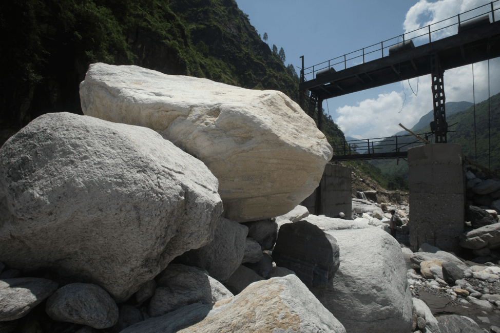
The barrage proposed for a 120 MW HEP on the Gori at Sarkari bhel will only be sightly taller than the one in the picture above. The flow volumes and the glaciers at the head of the Gori river, in comparison, are greater by an order of magnitude. WAPCOS’s estimation in its pre-feasibility report for this project, that if a barrage is built, it will be filled by bedload boulders within a couple of years is significant, and should not be brushed aside without adequate consideration.
On flow data for design considerations. The EAC may note that it was recommended during the Pre-feasibility stage, that site-specific flow volume and sedimentation rates must be assessed for the project. Under 3.8.3 under a subheading hydro-meteorology, the EIA says that “detailed hydrological studies have already been conducted in respect of 10-daily water availability series, probable maximum design flood and silt rate at the diversion site.” Immediately thereafter, citing poor data availability, the EIA quotes data that are derived from extrapolations on measurements from G&D stations at Tham and Pancheshwar, which are far downstream. These are gross estimates that were acceptable tentatively, in the Pre-Feasibility Report stage only, after which site specific data was required. Using flow and runoff volumes, and sedimentation rates based on data taken from far downstream, and extrapolated for relative catchment area will be dangerously misleading. This is because annual rainfall in just the Gori basin, for instance, can vary from 150 mm in the Tethyan Himalayan Zone, and over 4000 mm in the Greater Himalaya zone. And the proportion of these zones are not spread evenly across the geographical area of the basin. The data in the EIA is also unusable for sediment flow rates, or for bedload and granularity proportions because the data from Tham and Pancheshwar are far downstream and on very gentle gradient, which would be ca <1 in 50, whereas the Sarkari bhel site is >1 in 10.
The landslide hazard: The EAC may be aware that in 2014 an Australian consulting company SMEC, did a geological assessment for UJVNL, particularly with regard to the siting and design aspects for the Sarkari Bhel Rupsiabagar Project. In their layout optimization report (appended for your reference), they proposed reducing the HEP generating capacity by almost half, but more importantly, did a somewhat detailed study of some proximate landslides immediately upstream of the site proposed in the Pre-Feasibility Report. They concluded that the site proposed by WAPCOS was unsuitable due to the close and active landslides, and after considering three alternate sites, arrived uncertainly at the currently proposed site, with the caveat on page 31 that:
“Though this location cannot be categorized as an ideal location, however this is the best available compromise which can be made in the current site topographical limitations.”
We urge the EAC to please refer to the SMEC report, where they have mentioned serious landslides, nala fans and other debris flow hazards in some detail. The other ‘limitations’ not mentioned, however, is the fact that there are already 6 other large HEPs, both upstream and downstream of this project, whose PFRs have been submitted and data collection underway; so this project is severely constrained for alternate siting. A consulting company could hardly propose the scrapping of this project, and so have proposed what they call a ‘best available compromise’. What the EAC needs to know, is that even SMEC International, however good their work, did an incomplete job of estimating the hazard estimation and feasibility of the unsatisfactory, compromise site. They make no mention of the giant landslide upstream near Khilanch, which can be measured in square kilometers, and which has a massive accumulation of debris right on the riverbed, that has the potential to fill up the reservoirs of at least a hundred barrages of the size proposed by UJVNL at Sarkari bhel, in subsequent floods. The scale and impact of such landslides on any HEP on the Gori must not be ignored or taken lightly.

The landslide near Khilanch/Rilkot that started during an extreme rain event in 2005 and is still active. It repeatedly blocks the river and forms a lake behind it. This is upstream of the proposed Sarkari bhel HEP, but bears no mention in the EIA.

The lake formed by the temporary damming of the Gori by the Khilanch landslide (dotted arrows) in 2005. Photo from a paper by geologists S. P. Sati, Shubhra Sharma, Naresh Rana, Harsh Dobhal and Navin Juyal. The caption reads “…Breaching of such temporary lakes sends enormous quantity of sediments downstream that can jeopardize the sedimentation rate calculations for hydropower projects.”
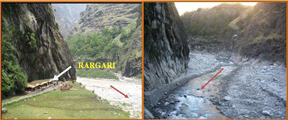
‘Catastrophic events like cloudbursts and flash floods’: Under this sub-heading, EQMS has written precisely 10 and a half lines, and has deliberately omitted any mention or history of this recurring hazard in this particular location. SMEC at least took this matter seriously in their report, and reported that the 2013 flood brought massive debris from the Jaulchida gad, and obliterated the entire bagar (floodplain terrace) at Rargari. The EAC may please see photo from the SMEC report below. Kindly note from the photos that the Rargari terrace, which was a camping ground and local inn, was already over 5 meters above the riverbed level. Most importantly, please also note that the height of the scour level on the cliff on the left above the terrace which has been washed away during the 2013 flood, is at least 10 meters above the terrace level. The riverbed level is at least 15 meters below the scour level on the rock cliff above where the inn used to be.
Had a barrage, like the one being proposed, been in existence during the 2013 flood, flood waters would have flowed at least 5 meters above the crest of the barrage, and sediment would have filled the reservoir capacity, in one episode.
Also related to the assessment required by the TOR on the possibility of Catastrophic Events Like Cloud Burst and Flash Floods, UJVNL says:
“The Goriganga is one of the most glaciated rivers of Uttarakhand. The river along with its tributaries and other rivulets in the project drainage area originate from glaciers only. The Milam glacier, from which the Goriganga originates, had been receding. A glacial lake is generally formed in the area so vacated by the glacier and the moraine bounded by ice among them holds the lake water. Under adverse- hot climatic conditions or its own hydraulic pressure such lakes may burst and the resulting wall of flood water along with huge debris mass cause unprecedented destruction in the downstream depending upon the size of the lake and the amount of debris it may carry. Fortunately, all such lakes in the basin are reported to be safe at present and the same have been accepted by CWC for upstream Bogudiyar-Sirkari Bhyol HEP. as such there is no possibility of GLOF for the proposed Sirkari Bhyol-Rupsiabagar HEP at present.”
So the Glacier Lake Outburst Flood hazard has been summarily dismissed by UJVNL/EQMS. The EAC may think it appropriate to ask for the survey report of the CWC in which they certified that there was no possibility of a GLOF along the Gori river, and for what duration their assessment is valid for, since the situation requires frequent monitoring and updating.
As the EIA itself acknowledges, the Gori river is among the most glaciated rivers in Uttarakhand, with around 27 glaciers upstream of this proposed barrage. It is well known that during de-glaciation, glacial lakes grow in number and size rapidly. A glacial lake in the Po Chu basin in Bhutan for example, is known to have increased 800 percent in the past 40 years. Such lakes do breach from time to time, resulting in catastrophic floods. Such breaches are often caused by earthquakes, by movement of glaciers or by overtopping during a rain-storm event, as during the flood in 2013 that wiped out all riverside habitations at Kedarnath and much else downstream. These are not rare events. At least 32 GLOF events recorded in the Himalaya have resulted in heavy loss to life, property and infrastructure and this will only be amplified with rapidly warming climate. In the context of building any infrastructure on, or in close proximity to glacial rivers, certifying that that there is no threat of GLOFs ‘at present’, is a dangerous dismissal, and cannot be taken lightly in view of the most recent episodes along the Rishiganga-Tapovan continuum.
On the seismic hazard of the area: As per the TOR, a site-specific study of earthquake parameters was to be done, and sent to the NCSDP (National Committee of Seismic Design Parameters CWC), for approval. To this the EIA has responded by saying that IIT Roorkee has carried out a study called “Site specific design earthquake parameters for Sirkari-Bhyol Rupsiabagar HEP” in 2017, and have suggested Maximum Credible Earthquake MCE) and Design Based Earthquake (DBE) conditions for their dam and powerhouse design.
It is also pertinent to ask, has the NCSDP, which has reportedly given a nod to this project in terms of seismic design considerations, have any experience with design and building of any dam that has withstood an earthquake of the magnitude in excess of MW 8, which has been predicted as anticipated in the region by numerous scientific papers by geologists? These larger questions apart, the site-specific study quoted in the EIA is inadequate and misleading for the following reasons:
- As per the requirements of the National Disaster Management Division of the Home Ministry, under IS 4967: 1968 (Recommendations for Seismic Instrumentation for River Valley Projects), five observatories were required to be set up, and at least 6 years before the design stage of the project, to be able to get adequate data. This has not been done.
- Nowhere in the EIA report by EQMS is there mention of the hot spring at Panchpal Udiyar. This hot spring is located less than a hundred meters from where the underground powerhouse cavern is proposed to be built. Such hot springs are a clear indication of a geological fault. The SMEC study report had mentioned this hot spring and suggested that further studies require to be undertaken to ascertain the threat posed by this fault, but the EQMS EIA, which has otherwise copied large sections of the SMEC report on other aspects, has deliberately eliminated all reference to this hazard.
- There is nothing in the EIA, in terms of the description and evaluation of the proximate geological faults in the region, in terms of whether they are thrust faults or strike slip faults; all crucially relevant for the design parameters of any dam structure.
- A further matter of concern is the fact that despite there being an overburden of 42 meters of sediment and debris above the bedrock, the barrage is proposed to be built, in a seismic Zone V area, on a permeable foundation. The EAC may please take note.
Sedimentation Studies: Under the subhead the EIA says:
“The project is a run of river project in which barrage bays with crest level at riverbed level have been proposed for flushing out the silt at regular intervals. Suitable sediment management practices like routine flushing during flood period will be evolved to avoid sediment deposition in the pond. Moreover, intake has been proposed to be located at suitably higher level above the spillway crest to prevent the entry of the silt in the water conductor system. As such sedimentation studies are not required.”
Despite sedimentation studies being an essential input for any dam design, and an important requirement under the TOR, the EAC is being told that “as such sedimentation studies are not required”. But what is worth not missing, is the statement preceding this; that the “intake has been proposed to be located at suitably higher level (sic) above the spillway crest to prevent the entry of the silt in the water conductor system.” The EAC may please note this most unusual design.
The Biological Assessment: Before we get into any details, first, the larger questions.
- The present EAC is probably aware that the Rupsiabagar-Khasiabara HEP which was proposed immediately downstream of the proposed Sarkari bhel-Rupsiabagar HEP was refused Forest Clearance by the EAC on the basis of the environmental impacts being found to be unacceptable. Even though its location was further downstream and there were villages in near proximity, and therefore it was a more disturbed site already. The location of the Sarkari bhel HEP is in a much more pristine location, with no villages nearby (please note, Sarkari bhel is not a village, as mentioned in the EIA, but just a parau, or camping ground, during transhumant migration). Please also recall that the EAC which rejected Forest Clearance to the Rupsiabagar-Khasiabara HEP, had done so after a site visit by one of India’s most eminent wildlife biologists, Dr. Ulhas Karanth. What could be the basis for granting clearance to the current proposal which is in an even more pristine area, and having even more endangered species (deliberately not mentioned in the EIA)?
- The EAC had also required that a cumulative impact assessment be done of all existing and planned HEPs along a river. We know that in just the Gori river, both upstream and downstream of the proposed Sarkari bhel project, there are seven large HEPs that have been proposed by the CWC and whose Pre-feasibility reports have been completed and presented. They are the Mapang-Budgiar, the Bugdiar-Sarakari bhel, the Sarkari bhel-Rupsiabagar, the Rupsiabagar-Khasiabara (stalled), the Devibagar-Khartoli (Goriganga IIIA), the Khartoli Lumti, and the Goriganga Stage II projects. As you can see just by their nomenclature, they are a cascade of bumper to bumper dam projects, which when operational, will convert the river from palustrine to lacustrine environment, with most of the riverbed stretches between them either dry or near-dry. We request that the EAC kindly ask for and consider a cumulative environmental impact assessment before taking a decision on this proposal at hand.
Regarding the specifics:
- The EIA was required to assess environmental parameters and likely impact for at least the area within a radius of 10 km from the proposed dam site called the study area. This has not been done by EQMS/UJVNL. A look at the section of the toposheet shown as the study area map will reveal that just the study area comprises of a wide range of altitudes and corresponding life-zones that encompass Nival, Alpine, Sub-alpine, Cold temperate, and Warm temperate. And a look at the species lists for fauna and flora show that they have only considered, and very superficially, the Warm temperate zones of the study area. This is woefully inadequate in terms of representation.
- The faunal and floral lists are fictitious. For instance, in their fauna list EQMS mentions mammals such as the five striped squirrel, the grey mongoose, the Indian hare, the flying fox, the golden jackal, and amazingly, the grey wolf! None of these mammals exist in the study area at all. The first five out of the nine listed in their reptile list, are not from the study area at all. Under trees they list species such as the Chir pine and the cypress, which do not exist in the study area. What is pertinent is that they have mentioned the places where these animals were either sighted by them, and that they are quoted in literature as well. They have not given any reference to the literature they mention in this regard. Perhaps the EAC may like to see the literature they have referenced, and whether it exists at all?
- Their omissions are even more telling. In the mammal list there is no mention of the snow leopard, common leopard, leopard cat, Himalayan black bear, musk deer, serow, barking deer, bharal, yellow throated marten, Assamese macaque, to name only the most obvious. As mentioned before, their species list as baseline, even for those that actually exist in the study area, are completely inadequate since they only represent a very limited area within the study area. Importantly, they claim that there are no fish in the study area, but give a list of species found much lower downstream. They have attached a certificate from the Fisheries Department in Pithoragarh saying that there are no fish in the study area, and nothing above Madkot, which is patently false. A conversation with even a child in Jimighat village (one of the closest habitations) would have revealed that there are Schizothorax in Sennar gad at its confluence with the Gori river.
- Their list of rare and endangered and threatened plant species mentioned in 3.43 they list two herbs; Euphorbia hirta which is a common pantropical weed, and Polygonum plebium which is found all over the plains of India. They even include the Chir pine in the table of such rare and threatened species, which though non-existent in the study area, is perhaps the most dominant forest species in the mid Himalaya.
- The many pages of a supposed analysis of species diversity and relative abundance of plants by means of the Shannon-Weiner Index analysis, as the distinguished biologists in the EAC can well see, is a ruse. They have filled pages with tables and algebraic equations, but the supposed outcomes are unusable, because they have taken just five sampling sites, and all representative of one altitudinal band, or ecosystem type only. Whereas even within each altitude band and corresponding vegetation type, they would have been required to take at least 20 sample sites each. And apart from just the numbers mentioned as species diversity and relative abundance, there is nothing in the text in terms of an analysis, about what this tells us about the state of the ecosystem, or what it means as a baseline. In the many pages describing the method of assessment employed by them, they promise a Shanon-Weiner seasonal peak abundance and diversity analysis for fauna as well, but do no such thing. This is a ploy used repeatedly throughout the EIA, perhaps with the assumption that the EAC will not have the time to read through a bulky document, much of it filled with lengthy descriptions of method and supposed importance (as if the EAC doesn’t know) but with no follow through. EQMS frequently resorts to flaunting a lab coat, as it were, to appear scientific and authoritative, as in the deployment of equations of the Shanon-Weiner Index, but without deploying the actual method, and with no useful analysis or outcome.
- The EIA claims that there is no wildlife corridor in the study area. This is untrue. While there may not be a designated wildlife corridor here, the entire landscape is a contiguous forest and wilderness area, and the river in particular, a corridor and a handrail for the seasonal movement, dispersal and refugia for birds and animals. The EAC may particularly take note of the proximity of the Nanda Devi National Park to the northwest, and the Askot Muskdeer Sanctuary towards the southeast of the study area, and see the contiguous wilderness that connects the two, of which the study area is a part.
- We would like to draw the attention of the EAC to EQMS/UJVNL listing the existence of the Grey Wolf both upstream and downstream of the dam site, and thereafter proposing Rs. 99 lakh in for the Management Plan, which includes anti-poaching operations, where the “deployment of special tiger protection force (STPF) shall be the main constituent of the plan.” While the DFO who has certified the budget may not have noticed this glaring irregularity on the part of EQMS, the EAC will know that the Special Tiger Protection Force can only be deployed in and around Tiger reserves, and not at the behest of a hydropower company, especially where there are no tigers. But what is of greater concern is this element that is found frequently in EIAs of hydropower companies, where they declare that poaching is likely to increase with the coming up of a dam (the reasoning is baffling), and that they must set aside money for paying informers from within the community (as this EIA does), and for weaponizing the area against local communities. And all this the name of conservation, and from a company whose dams will have a long-term and deleterous impact on the biological diversity in and along the river in the first place.
- We would like to submit to the EAC, that for assessing the impact of an HEP and thereby the radically altered rhythms and volumes of flow in a river, an assessment for a 10 km radius from the site is meaningless. The EAC will agree that there are linear flows, both upstream and downstream that affect the build-up of trophic levels right from Stream order 1 onwards, where habitats are formed and determined by water volumes, velocity, temperature and turbidity, and that trigger and enable dispersal, migration and breeding. The minimum flows currently permissible (euphemistically called environmental flows), such as 20 percent of average lean flows, much of which will constitute spates of silt flushing from the sedimentation tanks, will have an impact on the river ecology far beyond a radius of 10 kilometers. Not to mention similar and uncoordinated alteration of flows in succession from other dams along the river, both upstream and downstream. While our country can and will take a call on what environmental costs it is willing to pay for more electricity from hydropower, the environmental costs and losses should at least be truly reflected, to aid such decision making by the EAC.
Blind plagiarism: The EAC may have also noted the certificate from UJVNL stating that the contents of the report have not been copied from any other report. The entire EIA is littered with contradictory statements in different places. For instance, the Project is said to be located in the Lesser Himalaya, in one place, and in another, it is located in the Greater Himalaya. In one place they mention that the powerhouse is a surface powerhouse, and in another, an underground powerhouse. These are not spelling mistakes. What should leave the EAC with absolutely no doubt that there has been mindless copy-pasting, is the instance in section 4.9.1 that describes the demographic profile and Impacts on local community, where they say “Christians constitute the pre-dominant religious community of the study area. They have deep religious faiths and celebrate festivals with great fervors and enthusiasm (sic).” Where else but from an EIA from a project in the North East of India, could this be copied from? And once we know this, can we be sure of the credibility of any of their other tables and data?
In the Cost Benefit Analysis, it would surely be apparent to the EAC that the benefits are greatly exaggerated. They project that the creation of a silty little ‘pond’ (sic) behind their barrage, will attract tourists to visit and partake of water sports, which among other means of subsidiary employment, will be a ‘solution to the problem of migration’ from the area. After a preamble about the great deficit of electricity in the state, the CBA shows that the plan is to export most of the electricity out of the state, while leaving just 12% of ‘free’ electricity for use in the state. The cost of any other hydropower purchased by the state will be more expensive than from other sources. You are aware that Capital costs of hydropower have greatly increased from around Rs. 4 Cr per MW installed capacity, to over Rs. 10 Cr per MW. This has led to the cost of power from most hydro projects now being taken up, to be in excess of Rs. 5-6 per unit. The cost per unit from solar and wind power currently stand at Rs. 3 per unit, and are likely to drop further.
In its preamble, the EIA builds a scenario of a great deficit of electricity production. The reality, as the EAC would well know, is that the country is currently suffering from an excess power capacity. The national guidelines for EIAs clearly state that a “no project alternative” be considered during appraisal. Currently, with over 25,000 MW of stranded energy assets in the country and almost 20,000 MW already committed to be built, proposing this new project in this highly sensitive zone is, to say the least, illogical and unjustifiable.
We request the EAC to kindly consider all the issues raised, before taking a decision on the Sarkari bhel Rupsiabagar HEP in Uttarakhand.
We thank you, and look forward to your response.
Cc to Vice Chair, NDMA, Chief NDRF, DMMA (Uttarakhand) in light of the recent Uttarakhand landslide induced glacial flood incidence.
Signatories: (In first name alphabetical order)
Ashish Kothari, Pune
Prof. Bharat Jhunjhunwala, Srinagar, Uttarakhand
Emmanuel Theophilus, Munsiari, Pithoragarh District
Himanshu Thakkar, New Delhi
K. Ramnarayan, Ecologist, Munsiari, Pithoragarh District
Malika Virdi, Uttarakhand Mahila Manch, Munsiari, Pithoragarh District
Manshi Asher, Himdhara, Himachal Pradesh
Prakash Bhandari, Pithoragarh
Prof. Shekhar Pathak, Nainital, Uttarakhand
Sumit Mahar, Pithoragarh
Sreedhar Ramamurthy, Environics Trust
Prof. Uma Bhatt, Uttarakhand Mahila Manch, Nainital, Uttarakhand
Vimal Bhai, Matu Jansangathan, Uttarakhand

If power generation option is dropped the money saved can be used for improving river health and post monsoon flow.
LikeLike
From this report, it’s quite evident that the EIA report submitted to the EAC is false and there has been unlikely any study in depth has been done or are undergoing.
And the fear is that our power and water ministry will pass this too, to create another disaster zone and cascading consequences as it happens in the remote himalayan regions after a natural calamity.
Beg to ask, how much do our ministers get to fill their pockets after each of these grand scale devastating plans are passed? Because, without that kind of corruption, such destructive ideas can never be implemented. And they want us to believe in this growth model?
LikeLike
Are there some “guns” pointed at those in expert panels, saying, do as they say or are they too invited for higher positions post-retirement?
Any educated person can identify the gaps in between “vikas” and “vinash” strategies.
Besides, currently, there’s a trend. If anybody is objecting to Centre, they are termed anti-national, which is understandably a big Tina factor for our scientists and economists, in a panel, constituted meticulously, by the government itself.
LikeLike