
Accepting that reservoirs operation and flood management in India lack scientific supports, Madhavan Nair Rajeevan, Secretary, Ministry of Earth Sciences, in an interview has revealed that dams and water reservoirs need flood management systems that use scientific methods to understand when the time is right to open the gates.
“As per my understanding, no big reservoir has a decision support system. So we don’t know when to open them, how to open them… I am not attributing the Kerala floods to an individual. There is a common perception that in India most of the flood management systems are not supported by science… I am very sure we don’t have the decision support system and we need it.” https://indianexpress.com/article/india/not-just-kerala-no-scientific-dam-water-management-across-india-madhavan-nair-rajeevan-secy-earth-sciences-5322003/ (24 Aug. 2018)
In another interview he says that while Kerala records among the highest amounts of rainfall in the country, the State did not have a flood warning system in place. He added that while there were several sophisticated tools to anticipate extreme weather events, India still lacked a mechanism to effectively deploy them. https://www.thehindu.com/sci-tech/energy-and-environment/reservoirs-not-managed-using-a-scientific-decision-support-system-m-rajeevan/article24785253.ece (26 Aug. 2018)
Further in a detailed interview, he pitches for ‘decision support systems’ at dams, acknowledges the challenge of climate change, warn against repercussions of ‘fast-warming’ Indian Ocean. https://indianexpress.com/article/india/kerala-floods-m-rajeevan-ministry-of-earth-sciences-met-department-5324840/ (26 Aug. 2018)
MORE EXPERTS ARE CORROBORATING WHAT SANDRP HAVE SAID FROM THE BEGINNING ABOUT ROLE OF DAMS IN KERALA’S FLOODS.
– “Yes, the rainfall was extremely heavy; much more than Kerala receives at this time of the year. However, the IMD (Indian Meteorological Department) had predicted that the extremely heavy rainfall was very likely and the state should have taken the decision to release water from the dams that were almost full when the rains had subsided in July,” said an IMD official on condition of anonymity.
– “The flood damages could have been reduced by 20-40% had the dams and reservoirs released the water slowly in the two week period when the rains had subsided. The state did not have an advanced warning system in place and released water from the dams only once the danger levels (levels at which the dams structures can be damaged) were reached,” said Delhi’s Indian Institute of Technology civil engineering professor Ashok Keshari. https://www.hindustantimes.com/india-news/early-release-of-dam-water-could-have-reduced-kerala-flood-damages-say-experts/story-iknyHxWN1l51nuXPFAUSBJ.html (21 Aug. 2018)
- If extreme weather events are increasing under different climate change scenarios and there is not much that we can do to mitigate climate change, we certainly need to prepare ourselves to reduce the risk from such occurrences.
- The first and foremost step is to have a robust forecasting and prediction system.
- India has one of the best weather forecasting systems and some of the weather-related observatories are located on the Kerala coast, where the southwest monsoon makes its entry in June every year.
- The country has world-class remote sensing and weather and earth observation satellites that keep an eye on the Indian landmass.
- In addition, we have access to imagery from other agencies like NASA. Weather forecast and satellite data need to be used in synergy with ground data from reservoirs and dams to issue flood forecast and warnings.
- Then these warnings have to be conveyed to people and evacuation, if necessary, needs to follow.
- In this exercise, multiple agencies at central and state levels — scientific, technical, administration, government departments — are involved.
- Coordination and action is required in real time. This is where we are lacking.
For instance, the CWC — which is in-charge of flood forecasting — has no ground stations in Kerala for this purpose. In addition, as Himanshu Thakkar of SANDRP has pointed out, the magnitude of the disaster in Kerala could have been minimised “if dam operators had started releasing water in advance rather than waiting for dams to be filled up, when they have no alternative but to release water”.
If we are serious about tackling floods —annual floods in Assam, Odisha as well as floods triggered by extreme rainfall in other — we need an agency exclusively for this purpose. Such an agency should collect and analyses all hydrological data — rivers, dams, rainfall, glacier melt etc — and coordinate with other agencies like IMD and ISRO as well as the NDMA. All such information and data should be made publicly available. CWC has too many things on its plate and can’t effectively act as a flood forecasting agency. https://www.dailyo.in/variety/kerala-floods-central-water-commission-not-time-for-blame-game-but-why-dont-we-have-any-emergency-plan/story/1/26182.html (21 Aug. 2018)
Indeed, the Kerala flood has highlighted our poor dam management system: In India’s quest to control water, dams have always loomed large. But for dams to truly tame floods, experts say dam reservoirs need to be relatively empty before the onset of rains.
Back in 1924, a combination of heavy rain and a breached dam triggered deadly floods that claimed 1,000 lives. In 2018, history may have repeated itself. Under relentless downpours, poor dam management may have aggravated the floods, raising questions about the role of dams in Kerala and other states.
– According to Himanshu Thakkar, coordinator of the SANDRP, this was not the case in Kerala. The Idukki dam was already near full capacity by July-end even as rains were relatively weak (below normal levels) during that period.
– When the downpours arrived in August, the near full-capacity Idukki was forced to release water into already flooded areas. Thakkar believes this lack of foresight is common in India’s dam management and has worsened floods across the country. “Filling up the reservoirs before the end of the monsoon is an invitation to disaster,” he said over phone, adding that “while dams can help control floods, they need to be managed properly”. https://www.livemint.com/Politics/oSkzuw37GHm9u0UvbD0C5H/Kerala-floods-highlight-Indias-poor-dam-management.html (21 Aug. 2018)
Another report quoting Himanshu Thakkar, coordinator of the SANDRP writes that dams should not be filled up before the monsoon. Idukki dam was already filled in July. When Idukki was full they thought of releasing the water but didn’t release. They released after another calamity. CWC, India’s only flood forecasting agency, has no site in Kerala. You don’t have any way to guide you on what is coming. There was huge potential to reduce disaster impact if dams were not full. Mullaperiyar dam should not have been filled before the end of monsoon. https://economictimes.indiatimes.com/markets/stocks/news/sos-from-kerala-on-disaster-management/articleshow/65469269.cms (20 Aug. 2018)
MORE DETAIL HERE ABOUT THE WRONG DAMS OPERATION RESULTING IN FLOOD SITUATION DEVELOP INTO A DISASTER:
- Gopakumar Executive Director, Nityata River Otter Conservancy rightly says that India’s policy on dams has to be urgently reviewed:
– The tragedy in Kerala has highlighted the dangers of excess water accumulation in dams. The argument for dams — that they provide drinking water and water for agriculture — is today scientifically discredited. For independent geologists and hydrologists, dams represent a nightmare, an ephemeral triumph of engineering over common sense and the natural sciences. Increasingly, it is evident that dam proponents are ignoring crucial decision-making data now available on patterns of rainfall, geology and climate change.
– Worryingly, dams are far more hazardous than any other infrastructure project, except nuclear plants. It is also accepted today that dams can trigger seismic events. The reservoir-induced seismicity (RIS) from the weight of the reservoir has resulted in earthquakes in various parts of the country: of the 75 cases of RIS reported worldwide, 17 have been reported from India.
– There has never been a greater urgency to review India’s policy on dams and to act on decentralised alternatives that involve water recycling and reuse. The immediate task is to critically review every dam in the country, decommission those that are at end-of-life, stop building new ones and establish sound safety protocols. If this is not done, the time bomb will tick on. https://www.thehindu.com/opinion/op-ed/until-dams-do-us-part/article24786144.ece (26 Aug. 2018)
Our track record in managing floods around heavily dammed rivers, inter-state or otherwise, has been poor. Consider the 2009 floods in the Krishna river basin in North Karnataka and Andhra Pradesh. The heavy rain received between September and October that year resulted in unprecedented flooding of the many semi-arid regions of both states and Andhra Pradesh accused Karnataka of releasing water from its Almatti and Narayanpur dams without adequate notice.
Unfortunately, most inter-state basins do not have joint supervisory committees to communicate and coordinate dam releases during heavy rain. Even when they do, as in the case of the Cauvery or the Periyar rivers, they do not seem to be able to respond effectively to sudden heavy rainfall and floods. The failure of the disaster management sub-committee for Mullaperiyar to respond with the urgency required in the present situation is a case in point.
The CAG’s report on the 2015 Chennai floods said that excessive release from the upstream tanks was a major contributor and that the rules for operation of the tanks had not been updated for 23 years, not even after the 2005 floods.
States need to make the effort to generate and make available the best data and flow modelling/forecasting models to these committees and individual dam operators, and carry out a periodic scrutiny of reservoir operation rules. Having data is not to be confused with making data available and usable! Making all this data public will, at least, ensure that research groups make some of these connections and help the supervisory committees do their job. https://www.deccanchronicle.com/nation/current-affairs/260818/together-we-can-dam-the-destruction.html (26 Aug. 2018)
As per a reader, Ravindranath Dammalapati, Kerala like situation has also occurred in Karnataka and Andhra Pradesh in 2009 due to wrong dam operation, when, after a severe drought, the massive scale of floods occurred in Karnataka and Andhra Pradesh. Irrigation officials termed that event probably the maximum possible flood in 10,000 years. But could it have been better managed? NDTV tracks the causes for the floods.
Unprecedented rains in North Karnataka flooded several districts, cutting off areas like Bijapur, Bagalkot and Bellary. Karwar for instance got 50 cm of rain in a single day. Locals called it the heaviest downpour in 50 years.The waters inundated the Krishna and Tungabhadra rivers and the Karnataka govt released upto 8 lakh cusecs of water from the Almatti and Narayanpur dams, in a single day.
Srisailam dam, in a single day, had received over 25 lakh cusecs of water in 12 hours, whereas it is designed to get no more than 13.6 lakh cusecs. Next day, the maximum water limit was crossed in Srisailam, Jurala and Sunkesula projects causing inundation in many villages in the backwaters. Kurnool town and several villages in Kurnool, Mahbubnagar and Nalgonda districts were flooded.
From the Srisailam dam, the waters were flowing into Nagarjunasagar dam. 10.85 lakh cusecs were released to keep the masonry dam safe. The waters that reached Prakasam Barrage in the coastal Krishna district on Monday have submerged hundreds of villages. Prakasam Barrage has never received such huge amounts of water in the last 100 years.
Critics point out that the Andhra Pradesh govet could have better anticipated and prepared for systematic release of waters from the Sukeshu, Srisailam and Nagarjunasagar dams before matters got really out of hand. https://www.ndtv.com/india-news/what-caused-the-floods-402610 (5 Oct. 2009)
Himanshu Upadhyay about CAG report on Kerala Dams: A table in the performance audit report shows that out of 61 dams, none had Emergency Action Plan or O&M Manuals. Kerala had also stated, in response to audit query from CAG of India, “No dam-break analysis was conducted in respect to any of the 61 dams in the state.” https://www.downtoearth.org.in/news/kerala-floods-what-to-expect-when-none-of-the-61-dams-have-any-emergency-plan–61416 (21 Aug. 2018)
Heavy rain and landslides may have caused a major river tributary in Kerala’s Kozhikode district to split into two branches twice over the past two weeks, intensifying the flooding, water experts said. The branches later merged downstream, a scientist said, adding that extreme rain is unlikely to cause rivers to change course permanently.
The tributary named Iruvanjippuzha, which merges with the Chaliyar river, split into left and right branches on August 9 and August 14, V.P. Dinesan, a senior scientist at the Centre for Water Resources Development and Management, Kozhikode, said.
Scientists believe this happened because of bouts of intense rainfall upstream and massive landslides that deposited soil, boulders and trees into the river, hampering its natural flow. Water resources specialists say that extreme rainfall events are unlikely to change the geomorphology – land elevation and other terrain features – or the courses of rivers permanently. https://epaper.telegraphindia.com/imageview_211509_112954959_4_75_21-08-2018_1_i_1_sf.html (21 Aug. 2018)
Kerala blames sudden release of water from Mullaperiyar by TN a reason for floods Now legal battle begins over Kerala flood, where Kerala Govt is blaming Tamil Nadu Govt. for causing floods in Kerala by suddenly releasing water from Mullaperiyar dam. This only reinforces the fact that the mismanagement of dams was among prominent reason for aggravating flood situation in Kerala:
Kerala govt on Aug. 23 has told the SC that the sudden release of water from the Mullaperiyar dam by the Tamil Nadu govt was one of the reasons for the massive floods in the state.
In an affidavit filed by the Chief Secretary, the Kerala govt said that as the water level crossed 137 feet at Mullaperiyar Dam, authorities in Kerala decided to evacuate on a war footing people who lived in the dam’s downstream.
The Chief Secretary suggested that to avoid a repeat of such situations, the Supervisory Committee be headed by the Chairman of the Central Water Commission (CWC) with Secretaries of both the states as members and the panel should be empowered to take decisions by a majority opinion regarding operations during flood or similar crisis.
The Kerala govt also sought a management committee to manage the day-to-day operations of the Mullaperiyar dam, to be headed by a chief engineer/superintending engineer of the CWC with both chief engineers/superintending engineers of the two states.
The Mullaperiyar reservoir, which is wholly situated in Kerala, in the upper reaches of the Western Ghats above Idukki reservoir, is operated by the Tamil Nadu govt. https://www.thenewsminute.com/article/sudden-release-water-mullaperiyar-tn-reason-floods-kerala-sc-87139 (24 Aug. 2018)
Contrary to Kerala’s claims, Tamil Nadu has said that the volume of water released from the Mullaperiyar dam to Idukki is in fact far less than the quantity exceeded by Idukki and Idamalaiyar dams in Kerala. https://www.news18.com/news/india/not-mullaperiyar-keralas-own-surplus-water-caused-floods-tamil-nadu-files-counter-affidavit-1855185.html (24 Aug. 2018)
TN’s submission to SC on Aug 24 in response to Kerala: Further stating that the water released from Mullaperiyar was not the reason for flooding of the region, the document said, “The storage level in the Mullai Periyar Dam as on June 1 was 115.70 ft. and on August 14 at 8.00 A.M was only 136.1 ft. against the permitted storage level of 142 ft. The inflow was only 4419 cusecs with a diversion of 2200 cusecs through the tunnel to Tamil Nadu. On August 15, when the water level reached 140 ft., spilling of water to downstream of the dam commenced and the initial release was 4489 cusecs. This was gradually stepped up in the course of the day to 8905 cusecs and the average spilling was 14429 cusecs.
On August 15 morning the level rose to 140.7 ft. and the inflow was 16629 cusecs and the quantity spilled to Idukki Dam was only 14429 cusecs (1.247 TMC), whereas the outflow from Idukki Dam on the same day was 390.51 Mm3 or 13.79 TMC. On August 16, inflow into Mullai Periyar Dam was 25,730 cusecs and the quantity spilled to Idukki Dam was 23,397 cusecs i.e., 2.022 TMC and the outflow from Idukki Dam was 126.63 Mm3 (4.472 TMC). Similarly on August 17, 18 and 19, Idukki Dam surplused 114.84 Mm3, 70.52 Mm3 & 59.4 Mm3 respectively. Thus, the total quantity spilled from Idukki Dam from August 14 to 19, 2018 is 808.16Mm3 (28.54 TMC), and from Idamalaiyar dam in the corresponding period is 219 Mm3 (7.74 TMC) totaling to 1027.16 Mm3 (36.28 TMC), whereas the quantity released from Mullai Periyar Dam to Idukki Dam during the corresponding period is far less than the quantity surplused from Idukki and Idamalaiyar dams. Thus, it is seen that that flood surplus from the Idukki dam is mainly due to the flows generated from its own independent catchment due to unprecedented heavy rainfall while the contribution from Mullai Periyar Dam was significantly less. https://www.thenewsminute.com/article/tn-denies-kerala-s-charges-mullaperiyar-mismanagement-files-counter-affidavit-sc-87207 (25 Aug. 2018)
SC on Aug. 24 ordered that the water level at the Mullaperiyar reservoir in Tamil Nadu be maintained at at 139 feet until August 31 in view of the Kerala floods: The SC also directed the Tamil Nadu and Kerala governments to cooperate and follow the directions of the panel on the Mullaperiyar dam. https://timesofindia.indiatimes.com/india/maintain-water-level-at-mullaperiyar-at-139-feet-till-august-31-supreme-court/articleshow/65527470.cms (24 Aug. 2018)
Indeed, the tendency to store water to almost the full level of reservoirs is becoming a norm among water managers across States. In mid-July, Karnataka, too, started releasing surplus waters from the Kabini and Krishnaraja Sagar dams on the Cauvery system only when it knew that it could not hold any more water. Fortunately, the Mettur dam in the Salem district of Tamil Nadu is big enough to accommodate all the flood flows. For the last one month, Mettur, too, has been releasing excess water flows. In December 2015, Tamil Nadu also faced criticism for delaying the release of surplus water from the Chembarampakkam tank, causing floods in Chennai.
The colonial-era Mullaperiyar dam has again become a source of friction between Tamil Nadu and Kerala. Though the original dispute was over the appropriateness of the dam’s water level, Kerala, already reeling under severe adverse impact from floods, has surprised everyone this time by accusing Tamil Nadu of having carried out “sudden releases” of water. This, Kerala says, forced it to discharge more water from the downstream Idukki reservoir, about 40 km away from Mullaperiyar, which has been cited as one of the causes for the “deluge”. In Kerala’s assessment, Tamil Nadu should have heeded its request immediately and lowered the water level in Mullaperiyar to 139 ft for moderating floods. https://www.thehindu.com/news/national/the-hindu-explains-the-mullaperiyar-dispute/article24781895.ece (25 Aug. 2018)
The tension between the two states over the issue has persisted since the 1960s, with Kerala citing concerns regarding the dam’s safety and arguing for the reduction of the dam’s water levels. But with the water from the dam being diverted to five districts in Tamil Nadu and its importance in the state’s irrigation and power production practices, the state has consistently opposed this.
Although the dam is located in Kerala, it is operated by Tamil Nadu following an 1886 lease indenture for 999 years that was signed between the Maharaja of Travancore and the Secretary of State for India for the Periyar Irrigation works. Constructed between 1887 and 1895, the dam redirected the river to flow towards the Bay of Bengal, instead of the Arabian Sea and provide water to the arid rain region of Madurai in Madras Presidency. The lease is also the source of the many litigation surrounding the dam. https://www.news18.com/news/india/mullaperiyar-dam-999-year-lease-at-the-heart-of-acrimony-between-tamil-nadu-and-kerala-1856279.html (25 Aug. 2018)
“This is a man-made disaster in Kerala. This has happened only because (the) dams were opened without issuing the right warning at the right time. (The Kerala) govt had no assessment of the impact beforehand. No clear evacuation plan was put in place. The state is completely responsible for this calamity,” Ramesh Chennithala, Opposition leader in the Kerala Assembly, told media persons at hurriedly called briefing on Aug. 22.
What gives credibility to Chennithala’s words, instead of being seen as an attempt to scoring a political point, are the glaring lapses that have now come to surface in all 3 major dam-river systems that wreaked havoc on the lives of lakhs of citizens over the past week.
While the Idukki-Periyar system looks like a case of mismanagement, the Sabarigiri-Pampa system, and the Banasura Sagar-Kabani system’s opening did not warn the people sufficiently early. From the timing of the opening of the big dams to the early warning system that needs to be placed everything seems to have gone for a toss.
Prima facie, the state machinery in Kerala stands accused of dereliction of duty in the anticipation of a terrible calamity and all the good work it is now doing for rehabilitation is in danger of being undone by this crucial mistake that happened at the onset. Let’s takes a closer look at what went wrong at all the three places. https://www.firstpost.com/india/kerala-after-the-flood-despite-pinarayi-vijayans-rebuttal-govt-mismanagement-and-negligence-cant-be-ruled-out-5024701.html (23 Aug. 2018)
Further to this, M.M. Hassan, president of the Congress party in Kerala, on Aug. 23 demanded a judicial probe into what he said was the indiscriminate opening of sluice gates of dams across the state leading to devastating floods. https://www.ndtv.com/kerala-news/congress-wants-probe-into-opening-of-dam-shutters-in-kerala-1905004 (24 Aug. 2018)
The hilly district of Idukki has been thrown back by 40 years following Kerala’s worst flooding in a century, Power Minister MM Mani said on Aug. 26. Idukki is also home to some of the major dams which, when their sluice gates were opened after their water level came to choking points, caused unprecedented destruction all over the state this month.
Idukki received one of its highest rainfalls starting from the end of May till the middle of August. This pushed up the water levels in the Idukki, Mullaperiyar and other dams. The waters gushing out from the Idukki dam spread out far and wide, damaging everything that came in its way and forcing hundreds of thousands to take shelter in relief camps.
While rains and flooding caused widespread damage to crops and buildings, landslides damaged several key roads connecting the major towns in the district with interior areas. Idukki, especially Munnar, a picturesque hill station, took the worst beating. https://www.thenewsminute.com/article/idukki-has-gone-back-40-years-due-floods-says-kerala-minister-87286 (26 Aug. 2018)
– Kerala is usually considered a flood-proofed state with its undulating terrain. For a state that receives an annual average rainfall of nearly 3,000 mm, its natural landscape protects it from recurrent floods. However, the water released from reservoirs upstream compounded the waterlogging caused by heavy and incessant rains this year.
– Ironically, even as the people of Kerala watched the water from Cheruthoni dam tumbling down the Periyar river on August 10 on television, the authorities did not have an idea on how much it would flood in Aluva and how high would the water rise. With very good three-dimension satellite maps available it is easy to have simulation exercises for situations such as this. Preparedness and drills have to become part of the system. https://india.mongabay.com/2018/08/24/commentary-kerala-floods-time-for-introspection-and-amends-as-water-recedes/ (24 Aug. 2018)
Doyang Dam Flooding Assam Update Police quiz NEEPCO DGM Priyabrata Das, the deputy general manager of North Eastern Electric Power Corporation Ltd (NEEPCO), who looks after the operation of the Doyang Hydro Electric Project (DHEP) located at Wokha district in Nagaland, was on Aug. 16 evening questioned by the Golaghat police for nearly ten hours.
– Das appeared before the Golaghat police as he was summoned to appear before them. “Das was granted an interim bail by the Gauhati High Court and he was asked to appear before the investigating officer and accordingly he appeared. He said that he operated as per protocol and standard operating procedure,” said Partha Pratim Saikia, Golaghat deputy superintendent of police (DSP) who is also the investigating officer of the case. We will also issue summon to chairman of NEEPCO to appear in the due course of investigation, said Saikia.
– BJP legislator from Khumtai, Mrinal Saikia lodged an FIR against NEEPCO for the flood situation in Golaghat district. Based on the FIR the police registered a case (no. 578/18) under sections 120 B (punishment for criminal conspiracy), 304 A (causing death by negligence) of Indian Penal Code read with sections 3 and 4 of the Prevention of Damage to Public Property Act, 1984 which deals with mischief causing damage to public property and mischief causing damage to public property by fire or explosive substance respectively. https://nenow.in/north-east-news/assam-police-quiz-neepco-dgm-flood-golaghat.html (17 Aug. 2018)
Meanwhile, the dam was full again while the previous flooding had not yet subsided. https://www.telegraphindia.com/states/north-east/doyang-reservoirs-brimming-252815 (18 Aug. 2018)
DAM FLOODS Tamil Nadu 8 shutters of Mukkombu dam on Kollidam river collapse 8 of the 45 shutters of Mukkombu dam (Upper Anaicut) along with the piers have washed away after sudden increase of water in Kollidam river.
Officials from the Public Works Department (PWD), river conservation, said that earlier heavy flow of water had weakened the shutters. Efforts are on to divert the entire water into the Cauvery, officials said. A maximum of 1.80 lakh cusecs water was released into Kollidam when the inflow stood at 2 lakh cusecs in Stanley reservoir two days back.
Hundreds of villages in the area are facing a threat of flood. The Upper Anaicut is a dam built on the Kollidam river — a tributary of the Cauvery — about 18 km west of Trichy. Mukkombu is about 685-meter long (2283 foot), and was built in 1836 by British engineer Sir Arthur Cotton. https://timesofindia.indiatimes.com/city/trichy/tamil-nadu-eight-shutters-in-mukkombu-wash-away/articleshow/65506929.cms (23 Aug. 2018)
Though there was no immediate danger, an alert has been sounded in downstream areas along the banks of the Coleroon, officials said. The Coleroon river, essentially a flood carrier, begins from the Upper Anicut. The Upper Anicut is an important regulatory structure to divert surplus waters into the river to drain into sea. With the heavy discharge into the Cauvery river from Mettur Dam, over 1.50 lakh cusecs of water got diverted into the Coleroon from the Upper Anicut for more than 3 days last week. https://www.thehindu.com/news/national/tamil-nadu/regulator-across-coleroon-at-mukkombu-washed-away/article24755008.ece (23 Aug 2018)
Meanwhile, DMK has blamed the state govt for the damage at Mukkombu (Upper Anicut) and said the damage to the sluice gates only showed the AIADMK government’s “negligence” in the maintaining dams in the state. He urged the govt to carry out a survey on the safety of the dams in across the state.
Similarly, PMK leader and former Union Minister Anbumani Ramadoss blamed the state govt for the lack of maintenance and indiscriminate sand mining in the Coleroon river which led to the weakening of the dam and the subsequent damage. https://www.deccanchronicle.com/nation/current-affairs/240818/officials-inspect-upper-anicut-mk-stalin-wants-survey-of-dams.html (24 Aug. 2018)
DMK alleged that after the Coleroon bridge, the Mukkombu bridge had been damaged because of the AIADMK govt’s indifferent attitude towards the maintenance of the dams. The State unit of the Congress has also urged the govt to constitute a panel comprising experts and engineers to look into the issue of safety of dams across Tamil Nadu, in the wake of the incident.
In a statement, TNCC president Su Thirunavukkarasar alleged that illegal sand mining was a key reason for the overall lack of safety of dams and it should be stopped. PMK youth wing leader Anbumani Ramadoss rejected the State government’s reasoning that the shutters were washed away due to the discharge of 2 lakh cusecs of water. He called for a ban on illegal sand mining to protect the dams, the check dams and the bridges. https://www.thehindu.com/news/national/tamil-nadu/form-panel-to-study-dams-stalin/article24764584.ece (24 Aug. 2018)
Following the incident, the TNCC president S Thirunavukkarasar on Aug. 23 also asked the govt to undertake a quick review of various dams and reservoirs in the state to ensure their safety. https://timesofindia.indiatimes.com/city/chennai/review-safety-of-tn-dams-and-reservoirs-tamil-nadu-congress-committee-president-thirunavukkarasar-demands/articleshow/65519795.cms (23 Aug. 2018)
The Stanley Reservoir in Mettur (Salem District) attained full capacity of 120 feet for the second time this year on Aug. 11, after 5 years and there was heavy discharge into the Kollidam from Mukkumbu (Upper Anaicut). The old Kollidam steel bridge built across the flood carrier Kollidam, connecting Srirangam, famous of its temple, with the mainland, developed a major crack in the 18th pier on Aug 15.
Owing to the continuous inflow of water, the crack in the 18th pier widened. This had also weakened the 19th pier, leading to the collapse. The old steel bridge, Trichy’s historical landmark, has attracted the general public and tourists for its sheer engineering ingenuity.
The construction work for the old Kolidam steel bridge commenced in 1924 and concluded by 1928. The 792 metre long bridge with 24 spans laid across Killidam River connected No 1 tollgate junction with Srirangam island and had been heavily utilized for road transport till 2014. Citing the weak condition of the bridge, a new on was constructed a few metres away in 2014. https://timesofindia.indiatimes.com/city/trichy/two-piers-of-kollidam-bridge-break-plunges-into-raging-river/articleshow/65459161.cms (20 Aug. 2018)
The 90-year-old bridge across the Coleroon River in Tiruchi collapsed during the early hours on Aug 19. It had developed a crack on the 18th pier a few days ago due to heavy water current in the Coleroon. The bridge was abandoned about three years ago since the opening of a new bridge. https://www.thehindu.com/news/cities/Tiruchirapalli/bridge-across-tiruchis-coleroon-river-collapses/article24729532.ece (19 Aug. 2018)
Gujarat Flood Plain Zoning directive ignored; state may face Kerala-type devastation B N Navlawala, expectedly, does not mention role of dams or CWC, but says states are responsible for not ensuring flood plain zoning and adequate drainage. As per the report, 20 years ago, the safe carrying capacity of flood waters in Tapi River, passing through the city, was 6.5 to 7 lakh cusecs, which is now reduced to 2.5 lakh cusecs only due to man-made interventions, haphazard urbanisation and encroachments in flood plains of the river. More or less similar situation is with Gujarat’s other rivers like Sabarmati (in Ahmedabad) and Vishwamitri (in Vadodara). https://www.counterview.net/2018/08/centres-decades-old-flood-plain-zoning.html (25 Aug. 2018)
MONSOON 2018

Amid Kerala deluge, fear of drought in Karnataka & TN –Monsoon rain is 7% less in country, but surplus in South India. Met officials attribute the uneven distribution to peculiar features of this year’s monsoon, wherein strong westerly currently brought copious rainfall to the west coast, including Kerala and coastal Karnataka, while low-pressure systems originating from the Bay of Bengal mainly affected central India.
– Outside Kerala and coastal Andhra, half the districts in south India are grappling with deficient rainfall. Of the 95 districts in Tamil Nadu, Karnataka, Telangana and Rayalseema put together, 47 have had deficient rain so far (shortfall of 20% or more), including five where the deficit is more than 60%.
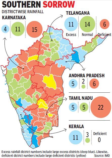
– Rayalseema is the worst hit. The subdivision has the country’s highest deficit of 42%, having received less rain so far this season than even west Rajasthan. North interior Karnataka is another subdivision in the red, with a shortfall of 21%.
– Even in Tamil Nadu, where the overall rainfall of -8% is in the normal range, 22 districts out of 32 in the state recorded deficient rain.
– The deficit districts are both along the east coast and in the state’s interior, while most districts along the Kerala border have had excess rainfall. Karnataka too shows the same mismatch between the state’s overall rainfall figure, which is 3% above normal, and districtwise data. Half of the state’s districts, 15 out of 30, have received deficient rain even as Kodagu reels under flood fury.
– Telangana has had a good monsoon, with late rains making up for early deficits. Only six out of the state’s 31 districts have major rain shortfall. Rain bounty has also showered on neighbouring coastal Andhra subdivision, which has received surplus rainfall of 21%.
– Flood-ravaged Kerala has a monsoon surplus of 40%, with 11 of the 14 districts receiving excess rains. South India is the only region to currently show a monsoon surplus.
– Central India, where rains have been good over most parts except Gujarat, has a tiny monsoon deficit of 0.3%. The deficit in northwest India is 6.7% while east and northeast India has a huge monsoon shortfall of 28.3%. https://timesofindia.indiatimes.com/india/amid-excess-rain-in-kerala-drought-fear-in-many-south-districts/articleshow/65522745.cms (24 Aug. 2018)
RAINS, LANDSLIDES IN HIMALAYA
Himachal Pradesh Rains wreak havoc in Kangra, Chamba “Continuous rains for the past 24 hours has damaged public and private property worth crores in Kangra and Chamba districts. At least a dozen houses, several shops and cow shelters were damaged across the Kangra district. According to the reports, 7 ‘kutcha’ houses were destroyed in Kangra sub-division only. There are reports of damage to houses and cow shelters in Baijnath and Jaisinghpur sub-division as well. Dharamshala experienced the heaviest rainfall at 292.4mm in Himachal Pradesh in last 24 hours followed by Palampur (86mm, Kangra (40mm), Mandi (38.4mm), Bhuntar (38mm), Dalhousie (17mm) and Manali (15.6mm). https://www.hindustantimes.com/india-news/rains-wreak-havoc-in-kangra-chamba/story-qwdXDUOXaCjoOry1jkOvFP.html (25 Aug. 2018)
Traffic on the Chandigarh-Manali national highway has been blocked following a massive landslide along the Beas river on Aug. 25. Nearly 100 metres of the national highway was badly damaged in the landslide that occurred near Aut in Mandi district on Aug. 24 night. Hundreds of vehicles remained stranded on both sides of the affected area. However, there were no reports of any casualties. https://www.news18.com/news/india/landslide-along-beas-river-blocks-chandigarh-manali-highway-1856469.html (25 Aug. 2018)
Arunachal Pradesh A woman died on the spot in a massive landslide that took place near Jorabat area on Aug. 23 night due to the heavy thundershower inundating the roadways. The incident took place near Jorabat’s, Shankardev Nagar. The sudden rains and thundershowers caused severe floods on the roads disrupting communication for several hours. The landslide further buried a few vehicles parked by the side of the road. https://www.time8.in/breaking-massive-landslide-in-jorabat-1-dead/ (24 Aug. 2018)
Uttrakhand Heavy rains were witnessed in most parts of the 7 districts of Garhwal region on Aug. 25 while in Haridwar, the water level of Ganga hovered near the danger mark of 294 m after incessant rain in the area over the past few days. Also, due to heavy landslides triggered by rain in Lambagarh area, the road to Badrinath was closed down. In some areas like Pauri districts’s Kotdwar, rains that had started on Aug. 24 evening continued through Aug. 25, inundating several areas. A woman in Pauri was reported missing after being swept away in a flooded canal in the area.
Rivers such as Malan, Shukhro, Kho and Kolhu were also in spate. As many as 131 rural roads of Uttarakhand were blocked for vehicular traffic. The overflowing of Pinyali, a rivulet, led to water logging in various areas, including Aam Padav, Shivalik Nagar and Suryanagar. In 2017 too, water from this rivulet has baused some damage in the region. In Haridwar the embankment at Kalsiya village in Laksar was partially damaged. https://timesofindia.indiatimes.com/city/dehradun/ganga-hovers-around-danger-mark-in-haridwar-landslides-block-road-to-badrinath/articleshow/65545919.cms (25 Aug. 2018)
An empty petrol tanker carrying 5 passengers got washed away by the swelling waters of Kotwali seasonal river on Aug. 24. However, according to unconfirmed source, all 5 of them managed to come out of the vehicle safely. https://timesofindia.indiatimes.com/city/dehradun/five-people-washed-away-in-seasonal-river-in-haridwar/articleshow/65535510.cms (24 Aug. 2018)
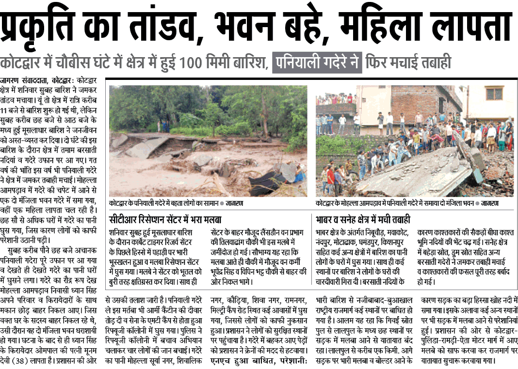
प्रकृति का तांडव, भवन बहे, महिला लापता: कोटद्वार में चौबीस घंटे में क्षेत्र में हुई 100 मिमी बारिश, पनियाली गदेरे ने फिर मचाई तबाही https://epaper.jagran.com/ePaperArticle/26-aug-2018-edition-garwal-page_3-15597-8610-105.html (26 Aug. 2018)
On Aug. 27 as the petition comes up before the SC challenging the decision of fresh hearing of Char Dham Highway case by NGT, concerned show deep concern for the ‘massive ecological damage’ that they say is being caused by the ongoing work in Char Dham Yatra Marg project in Uttarakhand. https://www.news18.com/news/india/frequent-landslides-in-uttarakhand-on-char-dham-yatra-marg-raises-questions-sc-to-hear-petitioners-today-1857485.html (27 Aug. 2018)
Study India among nations most affected by landslides due to human activities As per a study conducted by researchers at UK’s Sheffield University and published in the European Geosciences Union journal, Natural Hazards and Earth System Sciences, landslides triggered by human activities are on the rise around the world and India is among the most-affected countries, accounting for at least 28% of such events over last 12 years:
Researchers compiled data on over 4,800 fatal landslides which occurred from 2004 to 2016, leaving out those caused by earthquakes. While the trend is global, Asia was found to be the most-affected continent where 75% of landslides occurred, with a substantial number reported along the Himalayan Arc.
More than 56,000 people were killed by landslides around the world during the period, a majority of which involved a single slope, according to the study based on the Global Fatal Landslide Database (GFLD). At least 700 of these fatal landslides were caused by construction works, illegal mining and unregulated hill-cutting. https://www.livemint.com/Politics/vJOn6G5QmwK4EMTevhBiUL/India-among-nations-most-affected-by-landslides-due-to-human.html (24 Aug. 2018)
Data from the National Remote Sensing Centre shows that a moderate intensity quake measuring 3.4 on the Richter Scale struck Kodagu, Hassan and Chikkamgaluru and neighbouring Kerala, on July 9.
Exactly four days later, a low-pressure system began building in the Bay of Bengal, triggering the heaviest downpour in a 100 years, in both Kerala and Kodagu, causing losses of hundreds of lives and damage to crores worth of property, with homes and livelihoods left ruined with little hope of a recovery in the immediate future.
Karnataka is now battling a tragedy of enormous proportions, second only to the rain havoc in Kerala. And the worst affected areas are Kodagu and Sakleshpur in which the now blocked Shiradi Ghat is located.
Sources say that this oversight on the part of the government, comes after the rejection of the Kasturirangan report, which had stressed on the need to relocate villagers from many places, which ironically, have now been hit by landslides.
In fact there is an uncanny link between the July 9 quake and the landslides in Kodagu, Hassan and Chikkamagaluru – the quake line passed through Madikeri and Bisale via Narasimharajapura in Chikkamagaluru. Most of the landslides too have taken place along the same line. https://deccanchronicle.com/nation/current-affairs/230818/hd-kumaraswamy-govt-slept-through-34-earthquake.html (23 Aug. 2018)
According to the data base compiled by the Centre for Research on the Epidemiology of Disasters, the instances of extreme weather have gone up from 71 in the 1970s to about 224 in the 1990s and 350 in the first decade of the millennium. https://www.livemint.com/Opinion/w3QBtwsVp5i0ZQrZ9PRqyK/Opinion–Kerala-floods-An-unprecedented-tragedy-foretold.html (20 Aug. 2018)
HYDRO POWER
Study Climate Change Affecting Hydropower Generation in India “This study does not seem to take into account the increased disaster potential of the new rainfall patterns. There are other important factors also such as increased upstream water use, both surface and groundwater, reducing inflows for projects like Sardar Sarovar, Srisailam and Nagarjunsagar,” pointed out Himanshu Thakkar of SANDRP. https://www.researchstash.com/2018/08/20/climate-change-affecting-hydropower-generation-in-india/ (20 Aug. 2018)
Himdhara Press Release Last free flowing stretch of Satluj under threat! Raising objections to the granting of clearances to dams on the last free flowing stretch of the Satluj River, the Himdhara Collective, has sent a submission to the Expert Committee of Ministry of Environment demanding Cumulative Impact Assessment for individual projects on the Satluj river basin.
The committee, in its meeting to be held on 28th August 2018 is to consider the grant of Environment Clearance for SJVNL’s (Satluj Jal Vidyut Nigam Limited) 219 MW Luhri Stage I Hydro Electricity Project, that is proposed downstream of the 420 MW Rampur Project in Shimla and Kullu Districts. The SJVN was earlier to construct a 750 MW project with a 35 km long tunnel in this stretch.
The submission demands that the CEIA of Satluj river basin should be first finalized and till then, all projects on the Satluj river basin must be put on hold. The issue of dam building in the Himalayas has also now become a major concern amongst mountain communities and environmentalists given the threat of disasters like cloud bursts floods and earthquakes to the lives and economy of the region. http://hillpost.in/2018/08/last-free-flowing-stretch-of-satluj-under-threat/110750/ (26 Aug. 2018)
FAC to meet on Aug 30, 2018, it has three irrigation projects, all of Madhya Pradesh on agenda:
- DIVERSION OF 79.912 HA. OF FOREST LAND FOR CONSTRUCTION OF KAITH MEDIUM IRRIGATION PROJECT IN FAVOUR OF WATER RESOURCES DEPARTMENT, SAGAR DISTRICT MADHYA PRADESH STATE.
- PROPOSAL FOR DIVERSION OF 252.754 HA OF FOREST LAND FOR IN FAVOUR OF WATER RESOURCE DEPARTMENT FOR CONSTRUCTION OF JUDI MEDIUM IRRIGATION PROJECT UNDER THE CHHATTARPUR AND DAMOH DISTRICT IN THE STATE GOVT. OF MADHYA PRADESH.
- PROPOSAL FOR DIVERSION OF 148.75 HA OF FOREST LAND IN FAVOUR OF WATER RESOURCES DEPARTMENT, KHANDWA FOR CONSTRUCTION OF BHAM (RAJGARH) MEDIUM LIFT IRRIGATION PROJECT, IN KHANDWA DISTRICT IN STATE OF MADHYA PRADESH. http://forestsclearance.nic.in/AgendaDetail.aspx?id=205!dis1
Kerala Athirappilly Hydel Power Project Is a Recipe for Disaster, Shows RTI Reply Western Ghats Ecology Expert Panel (WGEEP) recommends that no new dams based on large scale storage be permitted in Ecologically Sensitive Zone 1 as defined by the Panel. Since Athirappilly hydel project sites fall in Ecologically Sensitive Zone 1, this project should not be accorded environmental clearance. Despite this, Kerala’s Athirappilly hydel power project has been the issue of fierce controversy.

The Kerala State Electricity Board (KSEB) proposed a hydroelectric dam across the Chalakudy River in Trichur district in Kerala, to generate 163 MW of power. Such was the defiance and arrogance that the then Kerala’s CM has termed opponents to this project as ‘anti-developmentalists’.
He and the KSEB were fighting with all their might to ensure that the dam is constructed, never mind the ecological devastation. Environmentalists, local tribal leaders and non-government organization (NGOs) have fought back tooth and nail to stop this project but their efforts at every stage have been nullified by the political leaders. https://www.moneylife.in/article/keralarsquos-athirappilly-hydel-power-project-is-a-recipe-for-disaster-shows-rti-reply/55109.html (24 Aug. 2018)
DAMS
Gujarat Earthquake hits Bharuch, epicentre near Narmada dam An earthquake measuring 3.7 on the Richter scale, with an epic centre near the Sardar Sarovar Dam built on the Narmada dam in Bharuch district of Gujarat was felt on April 21 evening, official sources said.
“The earthquake was epicentered 38 kilometers east-south-east of the Narmada dam and was felt at 4.56 pm. It was one of the larger tremors to hit the region around the dam in the recent past,” an official from Institute of Seismological Research (ISR) told The Indian Express. Data from ISR show that the quake happened at a 5 km depth near a dry river bed close to Panchasim village.
Though Kutch and Saurashtra are among the most active seismic zones in the Gujarat, the Sardar Sarovar dam lies near the Narmada rift zone has experienced shocks of the magnitude 5.4 at Bharuch in 1970. According to ISR, the Narmada fault has potential to produce earthquakes of 6.5 magnitude.
The seismic activity in Bharuch was among the largest tremors to strike the state in 2018. This year there were at least 4 earthquakes that were stronger than felt on April 21. Measuring between 3.8 and 4.8 on the Richter scale, all of them were in the more active Kutch and Saurashtra regions. The last recorded tremor in this region surrounding Narmada dam occurred on May 13, 2017 when an earthquake of 3 magnitude struck 119 kilometers east-south-east of Kevadia. https://indianexpress.com/article/india/gujarat-earthquake-measuring-3-7-hits-bharuch-district-epicentre-near-narmada-dam-5146591/ (21 April 2018)
Tamil Nadu Plea to divert surplus water from dams A petition has been filed before the Madurai bench of the Madras high court seeking the court intervention to divert surplus water from Maruthur and Srivaikuntam dams to the dry regions of Saathankulam, Tiruchendur and other regions in Tuticorin district. According to the petitioner, several petitions from farmer associations were sent to the concerned authorities to address the issue as the excess water from these dams are being wasted into the seas rather than filling up the bone dry regions in the district.
The two dams are fill with water from Thamirabarani river, the only perennial river in the state, originating in Tirunelveli district and confluences into sea at Punnakayal in tuticorin district. The petition stated that Thamirabarani irrigation system consists of 8 dams – 6 of which are in Tirunelveli and the remaining two in Tuticorin district. https://timesofindia.indiatimes.com/city/madurai/plea-divert-surplus-water-from-dams/articleshow/65507847.cms (23 Aug. 2018)
Cauvery delta not getting enough water from Mettur dam: Farmers slam Govt Farmers groups and activists have however slammed the government, alleging that corruption and rampant sand mining in the delta region were responsible for the shortage of water, despite the fact Mettur dam is seeing abundant water.
Close to 1,70,000 cusecs of water has been released from Mettur dam into the Cauvery this year, but farmers in Karur, Mannargudi, Tiruvarur, Cuddalore and Nagapattinam state that they have not received enough for irrigation purposes. They allege that water is simply draining into the Bay of Bengal due to the government’s unpreparedness.
The Public Works Department however denied it and said it is normal for the water to take 75 days to reach tail-end areas. It further added that three major channels of Cauvery River such as Puthiya Kattalai, Uyyakondan and Pullampatti canals have a length of 134 km, 87 km and 90 km respectively.
Meanwhile the State Govt sought to fend off criticism over the lack of water in tail-end areas of the Cauvery delta by blaming the ‘hilly terrain’ in the region. Farmers groups and activists have however slammed the govt, alleging that corruption and rampant sand mining in the delta region were responsible for the shortage of water, despite the fact Mettur dam is seeing abundant water. https://www.thenewsminute.com/article/cauvery-delta-not-getting-enough-water-mettur-dam-farmers-slam-tn-government-87021 (21 Aug. 2018)
Reservoirs go dry, Chennai stares at water crisis Chennai is staring at a possible water crisis as two of its major reservoirs Poondi and Cholavaram which are prime suppliers of drinking water to the city have gone bone dry. According to the Metro Water website on Aug. 25, the reservoirs have reached their dead storage levels with current water levels in both standing at a dismal 14mcft. As the present volume of all four prime drinking water sources to the city is merely 11% of its total capacity, officials said this will cater to the city’s needs only for the next two and a half months.
The combined capacity of lakes at Poondi, Cholavaram, Red Hills and Chembarambakkam was 2.43 tmcft in June 2018. In a month’s time the storage levels had dipped to 1.79tmcft with current level standing at 1.25tmcft as of Aug. 25. As reservoir levels have been steadily depleting since May, the city is majorly dependent on North East monsoons to avoid a water crisis this year end. Apart from these four reservoirs, the city is heavily dependent on water released from Veeranam Lake with 74-77 cusecs of water is being discharged every day into the Porur Lake said officials from Water Resource Department of Public Works Department.
Next major source of water, water from Krishna River, which was supposed to reach the state by October end maybe further delay as water levels at both Kandaleru and Somasila reservoirs in Andhra Pradesh are below transferrable levels, said Metro Water officials. As of August 23, storage levels at Kandaleru were at 3.95tmcft and 11.75tmcft at Somasila, both below the transferable level mark. http://www.newindianexpress.com/cities/chennai/2018/aug/26/reservoirs-go-dry-chennai-stares-at-water-crisis-1862833.html (26 Aug. 2018)
CM Edappadi K. Palaniswami on Aug. 19 said the government would build check dams across the State over the next three years at an investment of ₹1,000 crore. In the first phase, 62 such structures would be constructed at ₹292 crore this year. A committee, comprising retired chief engineers, has been formed to select the locations. It will submit its report in a few months, after which work will begin. https://www.thehindu.com/news/cities/chennai/check-dams-planned-across-tamil-nadu/article24733203.ece (20 Aug. 2018)
Talengana, Andhra, Maharashtra Full Krishna, Godavari dams bring cheer Most of the dams on the Krishna river, lifeline for many districts cross 3 States – Thungabhadra, Almatti and Narayanpur – have filled up, releasing water downstream into Jurala and Srisailam dams.
The Nagarjunsagar dam, which had poor inflows in the monsoon season till last week, causing alarm, has seen huge inflows lately with the dam storage level going up to 548.4 ft as against FRL of 590 feet and the storage was up at 207 tmc ft as against full storage capacity of 312 tmc ft.
Meanwhile, on the Godavari river network, the dams in Telangana, including the Sriramsagar project, are on on the verge of getting filled up. The flood water has hampered the construction work on the mega Kaleshwaram project in Telangana and Polavaram in Andhra Pradesh. https://www.thehindubusinessline.com/news/full-krishna-godavari-dams-bring-cheer/article24747020.ece (21 Aug. 2018)
Despite heavy inflows into Nagarjuna Sagar and Sri Pada Yellampally Project (Godavari) which meets over 80 per cent of drinking water needs of Greater Hyderabad and outskirt villages, Hyderabad Metropolitan Water Supply and Sewerage Board has ruled out the possibility of restoring daily drinking water supplies to the twin cities in near future.
Because of heavy rains, Nagarjuna Sagar is on the verge of brimming after a long time, as against FRL of 590 feet with a storage capacity of 312 tmcft, the present FRL level is 550 tmcft with gross present storage of water at 210 tmcft. Last year, on the same day, the FRL was 500 tmcft with water storage of 115 tmcft. Similarly, in Sri Pada Yellampally Project (Godavari), as against the FRL of 485 tmcft, the present FRL is 483 tmcft. Of the 20 tmcft of water, the present storage is about 19 tmcft.
Though the reservoir got filled up more than a week ago, additional inflows of water is being released downstream. The only worry for the Water Board is Singur reservoir where there have been no rains in the catchment areas of Nashik and Vidarbha region of Maharashtra state. Of the total capacity of 29.91 tmcft, the present available water is about 7.60 tmcft.
Water Board is supplying 465 million gallons of water per day (MGD). Of it, 260 MGD is being pumped from Akkampally reservoir (Nagarjuna Sagar), 140 MGD from Sri Pada Yellampally (Godavari) and remaining 27 MGD from Singur and 38 MGD from Manjira reservoirs. Water Board has completely stopped drawing water from Osmansagar and Himayatsagar. http://www.newindianexpress.com/states/telangana/2018/aug/22/despite-quenched-reservoirs-water-board-rules-out-daily-water-supply-to-hyderabad-1861064.html (22 Aug. 2018)
Finally on Aug. 24, the Water Resources Minister Devineni Umamaheswara Rao said the department was set to release 4,000 cusecs of water for irrigation for farmlands under Nagarjuna Sagar right canal ayacut. The release of water, which is the first time in four years, will help farmers of Guntur and Prakasam districts to go for ‘Magani’ crop during Kharif season, the minister said.
As per minister, the department has already released 7.5 tmc of water for drinking purposes. The minister also said that steps were being taken to keep all the reservoirs in the State full so as to divert the water to the farmlands through the canals. He added the CM has instructed the department to disburse the rehabilitation and resettlement package pending for the Owk tunnel. “200 crore towards this will be immediately released. Once the rehabilitation is done, 12 tmc of water can be stored in the region,” he observed. http://www.newindianexpress.com/cities/vijayawada/2018/aug/25/4000-cusecs-of-water-for-nagarjuna-sagar-right-canal-ayacut-1862477.html ( 25 Aug. 2018)
Maharashtra Water stock in dams rises to 60 % of total capacity With heavy rains in the last one week, the stock is at 1,119.13 TMC as of August 21, against 1,037.88 TMC on August 13, said the Water Resources Department. The water stock in dams was 53.39 per cent of the total capacity as of August 13, and it increased to 59.17 per cent by August 21, it said in a report. There was a dry spell in the first two weeks of August, but many parts of the state have reported incessant rains in the last seven days, it said.
Most of the rainfall has taken place over Marathwada, North Maharashtra, South Maharashtra and Vidarbha. Mumbai and Madhya (Central) Maharashtra regions received comparatively less rainfall during this period, the report said. There are 3,264 dams in Maharashtra with a total storage capacity of 1,720.09 TMC (thousand million cubic feet). https://mumbaimirror.indiatimes.com/mumbai/other/maharashtra-water-stock-in-dams-rises-to-60-pc-of-total-capacity/articleshow/65504870.cms (22 Aug. 2018)
The heavy discharge of water from 12 dams in the Bhima basin has increased the water level in Ujani dam. Over 15 TMC water was added to the dam’s stock in the last five days, irrigation authorities said. 3 dams, Varasgaon, Panshet and Khadakwasla around Pune were full, while Temghar was over 63% full on Aug. 22.
Ujani has the highest storage capacity among the dams in the Bhima basin. It can accommodate over 100 TMC water with live storage of 53.58 TMC. The water level had dropped below zero before the monsoon but since the beginning of the rainy season the dam has added more than 40 TMC. Last year, the storage was 100%. Sources in the irrigation department said for the second consecutive year, the water stock in Ujani may reach its maximum capacity. https://timesofindia.indiatimes.com/city/pune/three-dams-for-pune-fill-up-ujani-adds-15-tmc-in-5-days/articleshow/65507400.cms (23 Aug. 2018)
Water was released from 17 dams in Bhiam basin area on Aug. 21 after levels in most dams reached to full capacities in last few days. The Bhima basin has 25 major dams including four fams that supply drinking water to Pune city and rural parts. Officials in the state irrigation department said that most dams have received significant spells of rain in last 2 weeks which had led to increase in water levels up to full capacities. https://timesofindia.indiatimes.com/city/pune/maharashtra-water-released-from-17-dams-in-bhima-basin/articleshow/65503264.cms (22 Aug. 2018)
Karnataka Drones will carry out safety audit of major dams The State Govt is undertaking a safety audit and check of all major dams in the state. Water Resources Minister DK Shivakumar on Aug. 23, said that the audit is being carried out by experts, using drone cameras. He further said that there are no reports of any damage or leakage in any of the dams, but this is being done since CM HD Kumaraswamy had sought a report on the safety of dams in the backdrop of most getting filled to the brim. Shivakumar said his department will also conduct GIS mapping of dams pertaining to the irrigation department and document them. https://timesofindia.indiatimes.com/city/bengaluru/drones-will-carry-out-safety-audit-of-major-dams/articleshow/65521814.cms (24 Aug. 2018)
Kerala KSEB plans dam break analysis for 3 dams KSEB is mooting a dam break analysis for Idamalayar, Peringalkutthu and Sholayar dams. An emergency action plan, aimed at preparing the map of areas which will be flooded when the shutters of the dams are lifted, will also be prepared. KSEB is awaiting nod from central water commission for awarding Rs 6 crore works to an Australia-based firm in this regard.
The KSEB has already conducted a preliminary dam break analysis of Idukki dam by including it in the tier-I project as part of DRIP, but it covers only up to Lower Periyar. So, a fresh project which includes emergency action plan is also on the anvil. A simulation of dam failure and resulting flood waves will also be prepared as part of the dam break analysis. https://timesofindia.indiatimes.com/city/kochi/kseb-moots-dam-break-analysis-for-three-reservoirs/articleshow/65493882.cms (22 Aug. 2018)
On Aug. 18, there was a report mentioning some unusual seepage at KRS dam in Kerala. It was advised to reduce water level below 115 ft (dam ht 124 ft), but not yet implemented. Dam storage maintained above 90% as per officials, with inflow of 1.24 lakh cusecs and outflow of 1.12 lakh cusecs. https://timesofindia.indiatimes.com/city/bengaluru/unusual-seepage-at-krs-dam-raises-concern/articleshow/65456351.cms (19 Aug. 2018)
Odisha Spillway plan for dam safety The environment ministry has given clearance for construction of additional spillways for the safety of the Hirakud dam. The state government will construct five additional spillways at an estimated expenditure of Rs 369.53 crore for release of excess flood water. The spillways will be constructed at the left dyke of the dam and its water will reach river Mahanadi via Gujatala.The state has taken up this huge project for the safety of the dam according to the recommendation of the Central Water Commission.
– Once complete, the spillway will have the capacity to discharge an additional 7 lakh cusecs of water. Its present capacity is 15 lakh cusecs through its 64 sluice gates and 34 crest gates. https://www.telegraphindia.com/states/odisha/spillway-plan-for-dam-safety-253445 (21 Aug. 2018)
Center Water in India’s 91 major reservoirs at 63% of total storage capacity The water storage available across 91 major reservoirs of the country for the week ending on August 23, 2018, was 101.286 billion cubic meters (BCM), which is 63 per cent of the total storage capacity of these reservoirs. Among the regions, reservoirs in South India have a higher quantity of water stored thanks to rains in Kerala and parts of Karnataka. https://www.business-standard.com/article/current-affairs/water-in-india-s-91-major-reservoirs-at-63-of-total-storage-capacity-118082400709_1.html (24 Aug. 2018)
INTER LINKING OF RIVER
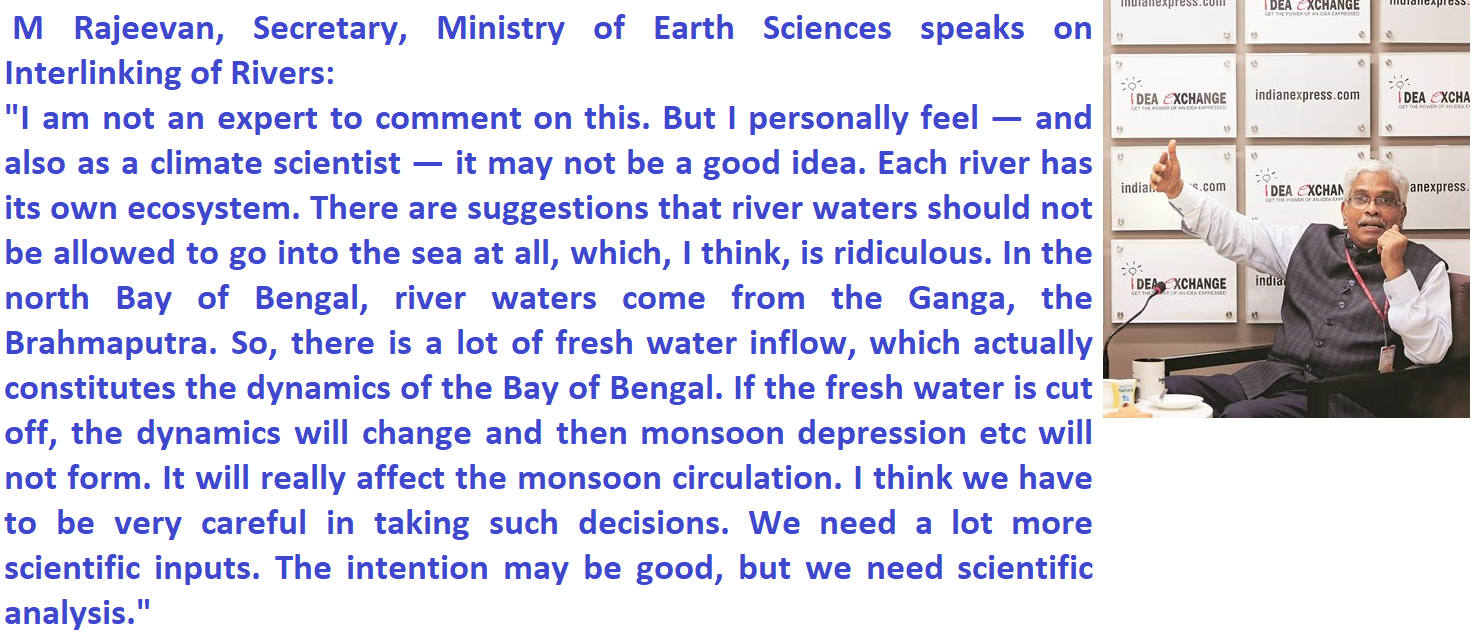
In this interview M Rajeevan, Secretary, Ministry of Earth Sciences speaks on Interlinking of Rivers: “I am not an expert to comment on this. But I personally feel — and also as a climate scientist — it may not be a good idea. Each river has its own ecosystem. There are suggestions that river waters should not be allowed to go into the sea at all, which, I think, is ridiculous. In the north Bay of Bengal, river waters come from the Ganga, the Brahmaputra. So, there is a lot of fresh water inflow, which actually constitutes the dynamics of the Bay of Bengal. If the fresh water is cut off, the dynamics will change and then monsoon depression etc will not form. It will really affect the monsoon circulation. I think we have to be very careful in taking such decisions. We need a lot more scientific inputs. The intention may be good, but we need scientific analysis.” https://indianexpress.com/article/india/kerala-floods-m-rajeevan-ministry-of-earth-sciences-met-department-5324840/ (26 Aug. 2018)
Centre Govt OKs DPR for Rs 648 cr river link project The water ministry has given its go-ahead to link the Pennaiyar and Palar rivers in Tamil Nadu. The project worth Rs 648 crore envisages diversion of 86 million cubic metre of floodwater from Pennaiyar river to Palar river by a canal stretching 54 km. The project will be implemented by the state govt and will cover Krishnagiri and Vellore districts. Also, the link canal would help in the recharge of the existing command area of 9,850 hectares and provide drinking water to 1.52 lakh people en route. https://timesofindia.indiatimes.com/city/chennai/centre-oks-dpr-for-rs-648cr-river-link-project/articleshow/65370710.cms (12 Aug. 2018)
INTER STATE WATER DISPUTES
Mahadayi River Water Dispute Karnataka govt to file appeal in SC The Karnataka govt will file an appeal in the SC against the recent verdict of the Mahadayi Water Disputes Tribunal.
The tribunal on Aug. 14 granted Karnataka 13.4tmcft of water against the state’s claim of 36.5tmcft. This includes 8.02tmcft for hydel power generation and 3.9tmcft of water for drinking. “We are not happy with the tribunal’s verdict, so the legal team has suggested filing an appeal,” Shivakumar, the water resource minister said. https://timesofindia.indiatimes.com/city/bengaluru/drones-will-carry-out-safety-audit-of-major-dams/articleshow/65521814.cms (24 Aug. 2018)
At the same time, the opposition Party in Goa has also asked Govt to challenge tribual’s verdict on sharing the Mahadayi river water with neighboring states in SC. Parting away with water of the Mahadayi river (known as Mandovi in Goa) will have a “long-term impact” on Goa, the main opposition party has said. https://indianexpress.com/article/india/challenge-mahadayi-river-tribunal-verdict-in-sc-goa-congress-5311605/ (17 Aug. 2018)
The information about Mahadayi River Water Disputes and Central Govt steps to resolve it can be seen here. http://mowr.gov.in/acts-tribunals/current-inter-state-river-water-disputes-tribunals/mahadayimandovi-river
RIVERS AS NATIONAL WATER WAYS
Kerala Waterways on the front burner again With the Centre unclogging fund flow for inland waterways, the state govt has put the 610-km project connecting its northern and southern parts in the fast lane. Boosting its prospects is the Inland Waterways Authority of India’s (IWAI’s) decision to pick up a majority stake in the Kerala Waterways Infrastructures Ltd (KWIL), the special purpose vehicle that is implementing the Rs 2,300-crore West Coast Canal (WCC) project. Earlier, Kerala has had a rethink on its inland waterways project which it had been soft-pedalling, given the views of planners like E Sreedharan that it could cost a humongous Rs 10,000 crore. https://www.financialexpress.com/infrastructure/keralas-waterways-on-the-front-burner-again-this-rs-2300-cr-project-could-take-over-100-trucks-off-states-roads/1285614/ ( 20 Aug. 2018)
URBAN RIVERS

Vishwamitri, Gujarat On the banks of Vishwamitri or ‘Gutter Ganga’ Through VEDITUM Blog, Jubin Mehta highlights the plight of Vishwamitri River of Vadodara. Originating from the Pavagadh hills, Vishwamitri is a small (135km) but an important river, like all natural water bodies. Over the last many decades, this beautiful river has been reduced to an urban drain. All of the sewage waste from the sprawling city of Vadodara and industrial waste from the major factories in the vicinity is thoughtlessly dumped into the river.
Apart from this, uncontrolled construction and building on the flood plains add to the woes. Over the last two decades, there have been efforts by individuals, NGOs, and many others to try and revive the river. The driving force however needs to come from the VMC (Vadodara Municipal Corporation) which currently seems absent. As the river stands today, it is a very sorry sight. http://veditum.org/environment/on-the-banks-of-gutter-ganga/ (22 Aug. 2018)
RIVERS
Bhadar River, Gujarat Textile units polluting Bhadar river Unabated pollution of Bhadar river by textile dyeing and printing units of the Jetpur town going on. All the units under the common effluent treatment plant (CETP) in Dhareshwar Gujarat Industrial Development Corporation (GIDC) are lying inoperative since a long time, and thousands of litres of untreated industrial effluent from all the textile dyeing and printing units of the Jetpur town are being directly released into the Bhadar river, which caters to the drinking water needs of more than 400 nearby villages. https://indianexpress.com/article/cities/ahmedabad/untreated-industrial-effluent-being-released-into-bhadar-river-by-govt-run-units-5313811/ (19 Aug. 2018)
Twenty-six sari printing units at Dhareshwar GIDC of Jetpur have received third closure notice from GPCB as they have not upgraded their effluent treatment plant and are releasing untreated effluent into Bhadar river. https://timesofindia.indiatimes.com/city/rajkot/26-sari-units-shut-over-pollution/articleshow/65456298.cms (19 Aug. 2018)
Bhiwandi River, Maharashtra College students take up drive to revive lakes, rivers Bhiwandi has more than five lakh power looms and more than 225 dyeing, printing and processing units. Of the 225 units, 45 are large-scale dyeing and printing units. But all effluents from the looms are released into the water bodies.
Kamwari river is one of the polluted water bodies in the city. The river that dates back to the 16th century used to be a port during the British-Era and was once a tributary of the Ulhas river and went on to the Thane creek. Once a big river that used to help transport cargos, has now reduced to the size of a nullah and is as polluted as one. https://indianexpress.com/article/cities/mumbai/bhiwandi-college-students-take-up-drive-to-revive-lakes-rivers/ (23 Aug. 2018)
Ami River, Uttar Pradesh आमी नदी के प्रदूषण पर एनजीटी नाराज, कहा –जिम्मेदार संस्थाएं काम नहीं कर रहीं Ammi River, Gorakhpur is heavily polluted by industrial waste:
एनजीटी ने आमी नदी प्रदूषण मुक्त किये जाने के संबंध में दिए गए आदेशों का अनुपालन न होने पर सख्त नाराजगी जताई और कहा कि सभी संस्थाएं अपनी जिम्मेदारी से भाग रही हैं। एनजीटी ने कहा आमी पूरी तौर पर प्रदूषित हो चुकी है और इससे गंगा भी प्रदूषित हो रही है. एनजीटी ने कि उत्तर प्रदेश के मुख्य सचिव के नेतृत्व में हाई पावर कमेटी बनातेे हुए कमेटी को 3 महीने के अंदर किये गए कार्य की प्रगति रिपोर्ट और एक माह के अंदर आमी कैसे साफ होगी इसकी नीति तय कर कोर्ट को बताने का आदेश दिया. http://gorakhpurnewsline.com/national-green-tribunal-angry-on-the-pollution-of-ami-river-said-responsible-organizations-are-not-working/ (23 Aug. 2018)
GANGA Namami Gange: In India Today’s RTI response Government of India said, “A total of Rs 20,000 crore has been allocated for this project, to be spent over the next five years (2020)”. It further said: “till date, under Namami Gange programme, a total 221 projects have been sanctioned for various activities such as treatment of municipal sewage, treatment of industrial effluent, river surface cleaning etc., at a total cost of Rs 22,238.73 crores, out of which 58 projects have been completed”.
This suggests that an additional Rs 2,238.73 crore has been allocated, with a year and a half to go. The government also admits that so far, only 26 per cent of the sanctioned projects have been completed.
Talking about sewage treatment plants, the RTI response says: “Till date, a total 105 sewerage infrastructures and STP projects have been sanctioned, which will prevent 3293.68 MLD of untreated sewage discharging directly into river Ganga. Total 26 projects have been completed so far”.
Here too, only around 25 per cent of the sanctioned projects have been completed. The government further says that “the projects taken up so far will take care of all the interventions required in respect of sewage. https://www.dailyo.in/politics/namami-gange-narendra-modi-ganga-water-pollution-rti/story/1/26243.html (24 Aug. 2018)
Same report can be seen in Hindi here: https://aajtak.intoday.in/story/government-may-miss-deadline-of-cleaning-ganga-once-again-1-1023958.html (24 Aug. 2018)
YAMUNA Delhi Yamuna is dead for all practical purposes An analysis of the Delhi Pollution Control Committee’s Yamuna water quality data has revealed that despite several SC and NGT orders, almost the entire stretch of Yamuna in Delhi continues to be severely polluted. In fact, the intensity of pollution may have increased in the last 4-5 years. https://timesofindia.indiatimes.com/city/delhi/oxygen-levels-show-why-yamuna-is-dead-for-all-practical-purposes/articleshow/65554763.cms (27 Aug. 2018)
DJB has approved a policy for enforcing decentralised waste water treatment systems across the capital. DJB will now give 90% rebate on sewer charges for those using such plants for water recycling. DJB also approved appointment of WAPCOS as the consultant for rejuvenating 12 waterbodies, commissioning of study for utilisation of 456MGD water from STPs, and sewer and water lines under the sewerage master plan 2031.
However, the Badshapur drain, drain number 6 carrying industrial effluents from Panipat industrial area and drain number 8 in Haryana will continue to create obstacles in the Yamuna cleaning project. https://timesofindia.indiatimes.com/city/delhi/djb-focuses-on-decentralised-stps/articleshow/65536538.cms (25 Aug. 2018)
With the December deadline for the interceptor sewage project drawing closer, DJB has decided to launch an interceptor+ project, which will cover around 200 smaller drains left out of the original plan. DJB maintains 242MGD (million gallon tonnes) raw sewage from the three main drains will be diverted to six sewage treatment plants, making the Yamuna cleaner.
Officials argue the original project alone is expected to divert more than 250MGD raw sewage to Kondli, Yamuna Vihar, Dwarka, Rithala, Coronation Park and Nilothi/Keshopur treatment plants. Around 850MGD raw sewage now falls directly into the river. https://timesofindia.indiatimes.com/city/delhi/how-interceptor-will-reduce-sewage-flowing-into-yamuna/articleshow/65536531.cms (25 Aug. 2018)
SAND MINING
Tamil Nadu Miners demand govt to open sand quarries Tamil Nadu State Sand Lorry Owner’s Federation president S Yuvaraj has urged the govt to open sand quarries on dry river courses. “The state requires 20,000 loads of sand for construction activities every day. Of these, 7,500 loads are meant for real estate activities in Chennai, Kancheepuram and Tiruvallur districts,” he said. In the backdrop of the sand mining ban in Kancheepuram and with few resources available in neighboring Tiruvallur, the govt could open more quarries at Villupuram to meet the demand, he added.
R Panneerselvam, coordinator of the Tamil Nadu Stone Quarry and Sand Lorry Owners Welfare Association, said quarries functioning at Maruthadu in Cuddalore district and Gurupuram near Uthukottai at Tiruvallur district were the two sources for river sand. “They will collectively cater for just 300 loads. This has reflected on sand prices spiralling to ₹55,000 for three units (300 cubic feet),” he said. Noting that about 75% of the market demand is met by manufactured sand (M Sand), he said, “the alternative construction material was catering for 60% of construction activities when higher number of sand quarries were operating.”
At present all sand quarries, except for two in Cuddalore and Tiruvallur districts, have been shut, pushing the prices of river sand to a new high. https://timesofindia.indiatimes.com/city/chennai/rising-rivers-gladden-hearts-of-sand-mining-industry/articleshow/65479889.cms (21 Aug. 2018)
Mukkombu Regulator Collapse Incident Experts blame lack of maintenance and sand mining leading to the dam collapse The absence of periodic maintenance has been cited as the main reason for the collapse of the 182 year old regulator at Mukkombu. The yearly maintenance covers only painting work and greasing of shutters and chains, and the officials concerned had failed to examine the strength of the regulators. Meanwhile, farmers blamed indiscriminate sand mining for the collapse.
Since Mettur dam opens its shutters between June 12 and Jan. 28, it remains idle for the remaining 5 months. During this period, a complete inspection of the dam should be done by the PWD authorities. Since the structures are old, the govt should undertake proper maintenance to keep the system intact, points out Mannargudi S Ranganathan, general secretary, Tamil Nadu Cauvery Delta Farmer’s Welfare Association. He also said that for more than last 10 years, system tanks have not been properly desilted as over the years, the govts have not allocated the required fund for the purpose.
The state secretary of Senior PWD Engineers Association, A Veerappan said that the continuous heavy flow in Kollidam river for more than 10 days as a reason for the collapse. He also said that the structure is a regulator and not a dam hence govt would not allow huge fund for maintenance of it. Environmentalist A Ganapathi said that sand mining was the reason for the deterioration of such structures in rives and water bodies. As per him, due to sand mining Cauvery and Kollidam rivers were losing water retaining capacity. https://timesofindia.indiatimes.com/city/trichy/lack-of-periodic-maintenance-sand-mining-lead-to-collapse-experts/articleshow/65522506.cms (24 Aug. 2018)
On Aug. 24, the CM K. Palaniswami inspected the breached Mukkombu regulator and said the washing away of its 9shutters in the rain-floods of Cauvery was due to the age of the British-built structure and not because of indiscriminate sand mining as alleged by locals and environmentalists. He also announced construction of a new bridge about 100 metres from the collapsed structure at a cost of Rs 410 crore. https://www.deccanchronicle.com/nation/current-affairs/250818/only-age-not-sand-mining-caused-mukkombu-damage-tn-cm.html (25 Aug. 2018)
Illegal sand mining under the rule of Dravidian parties in the state has led to the damage of the Mukkombu regulator and Kollidam bridge in Trichy, claimed BJP national secretary H Raja at Thiruthuraipoondi in Tiruvarur district. The BJP national secretary also alleged that over the last 50 years the water resource management in Tamil Nadu has not been carried out properly and only because of that the state is s facing a lot of issues. https://timesofindia.indiatimes.com/city/trichy/raja-collapse-of-regulator-bridge-due-to-sand-mining/articleshow/65546425.cms (25 Aug. 2018)
LAKES, WETLANDS, WATER BODIES
Tamil Nadu Lessons from Madurai, a city that adopted tanks and suffered after abandoning them by India Mridula Ramesh Today, many Indian cities rely overtly on the provision of water from reservoirs and a seemingly-never-ending groundwater supply, while not focusing enough on management. Meanwhile, a majority of city dwellers are water-stressed, and water sources are becoming more volatile.
This is very elaborate and informative piece on tanks syst of Madurai, that once were center to community life and assurance of sustainable water supply, but for past several decades, have been succumbing to Govt’s apathy and public negligence, one by one. Indeed growing reliance on dams, short termed govt policies, increase in water demand & consumption, unplanned urbanization and many other reasons have collectively contributed in destruction of the tanks system. https://www.firstpost.com/india/indias-water-crisis-lessons-from-madurai-a-city-that-adopted-tanks-and-suffered-after-abandoning-them-5011701.html (22 Aug 2018)
GROUND WATER
NGT directs 5-star hotels to seek permission for groundwater extraction Green Tribunal on Aug. 22 has directed five-star hotels in the national capital to seek permission from the Central Ground Water Authority (CGWA) for extraction of groundwater and inform it about the quantity required by them. A bench headed by Justice R S Rathore also asked the hotels to inform CGWA since when the extraction of groundwater was being done and the monthly quantity taken out by them.
The green panel said after receiving an application from the hotels, the CGWA should decide the same in accordance to law within a month and if it was found that total extraction of water by them was in excess of the permissible limit, they should take action. https://www.timesnownews.com/mirror-now/in-focus/article/ngt-directs-5-star-hotels-to-seek-permission-for-groundwater-extraction/273554 (22 Aug. 2018)
Uttar Pradesh Noida’s groundwater level falling by 1.5 metres every year Recent data from CGWB shows water level has been depleting in Gautam Budh Nagar at an average rate of 1.5 metrs every year for the past five years. In Noida region, according to CGWB, the average water table dropped to 24.13 metres in 2017 from 18.22 metres in 2013, while in Greater Noida, it fell to 11.11 metres last year from 7.95 metres five years back. Similarly, in Dankaur, the water level went down to 7.46 metres in 2017 from 5.54 metres in 2013. An in Jewar, the water table can down to 5.60 metres last year from 4.34 metres in 2013.
In neighboring Delhi, the situation is serious. The water level has been decreasing from 0.5 metres to over 2 metres per year at different places in Delhi and could trigger a crisis if not halted, the CGWB told the SC in May this year. What has added to the worry of experts is the rate at which the twin cities are expanding. https://timesofindia.indiatimes.com/city/gurgaon/noidas-groundwater-level-falling-by-1-5-metres-every-year/articleshow/65522432.cms (24 Aug. 2018)
Telangana State exploiting 65 per cent of its groundwater resources As per the recently released ‘Dynamic Groundwater Resources of Telangana State’ report for 2016-17, Telangana has 12,361 MCM (436.5 TMC) of groundwater, of which 8,084 MCM (284.5 TMC) was extracted in 2016-17, which is around 65 per cent of the entire groundwater resource, an increase from the 58 per cent reported for erstwhile ten districts of Telangana when a similar report was released earlier in the erstwhile Andhra Pradesh in 2012-13.
The report mentions that there are 14 lakh borewells in the state. However, these figures only pertain to registered borewells, mostly used for agriculture purpose, and there must be lakhs of borewells used for agriculture as well as for industrial and drinking purposes, that are not registered under Water, Land and Trees Act (WALTA).
Almost half of Telangana is experiencing dangerous levels of groundwater exploitation. Speaking in numbers, at least 14 lakh bore wells have been sunk in Telangana that extract, on an average, 65 per cent of the entire groundwater resource of the State. The report would be the first groundwater estimation report since the formation of Telangana. The last report was brought out in 2012-13. http://www.newindianexpress.com/states/telangana/2018/aug/25/telangana-exploiting-65-per-cent-of-its-groundwater-resources-1862522.html (25 Aug. 2018)
Punjab Fluoride, nitrogen 4 times the limit in Malwa water Fresh evidence of the presence of alarming levels of chemicals in the ground water in the Malwa region has emerged in two separate reports on fluoride and nitrogen toxicity, with certain districts registering more than four times the acceptable limits. The studies, based on chemical analysis of water samples taken from 16 districts of Malwa, have found the presence of fluoride and nitrogen in excess of limits prescribed by the World Health Organisation (WHO) and the Bureau of Indian Standards (BIS), qualifying them to be labelled “higher-risk zone”. The studies were conducted in Malwa in view of the high exploitation of the region for agriculture, and also it being a geological continuation of the Thar desert that has high fluoride presence. https://www.tribuneindia.com/news/punjab/fluoride-nitrogen-4-times-the-limit-in-malwa-water/643016.html (26 Aug. 2018)
Haryana Mahendragarh to have 20-km canal to recharge groundwater The Irrigation Department will construct a 20-km-long canal between Deroli Ahir and Pali villages in the district to recharge groundwater. The canal will pass through around 15 villages and surplus water will be used to fill the canal. The state govt had recently sanctioned Rs 2.90 crore for the project. Sources said the project had been chalked out following the demand by sarpanches of various villages, who expressed concern over the persistently depleting water table in the district during a meeting around six months ago. https://www.tribuneindia.com/news/haryana/m-garh-to-have-20-km-canal-to-recharge-groundwater/641775.html (24 Aug. 2018)
URBAN WATER
Op-Ed In a rapidly urbanizing India, it’s time to re-imagine water in cities By Veena Srinivasan Groundwater from replenished aquifers seeps into streams through the dry season. Cities fundamentally transform the natural water cycle. As land gets paved and green cover disappears, very little rainwater infiltrates. Evapotranspiration is much lower and almost all the rain ends up as run-off.
This is not a problem in itself. Generations of civil engineers have been trained in stormwater design with one objective—to build pipes large enough to transport water from a “50-year storm” (intense rain event that occurs, on average, once in a 50 years) as quickly as possible. Climate change has complicated this by increasing the frequency of such “extreme events”. This makes it necessary to revisit long-standing engineering design thumb rules. https://www.livemint.com/Opinion/NaP99WBJWe9AWnvK2BtQwI/Kerala-lessons-In-a-rapidly-urbanizing-India-its-time-to.html (23 Aug. 2018)
SOUTH ASIA
Pakistan Govt to Continue Water Talks with India this Week Pakistan will reiterate its serious objections over two water storage and hydropower projects being built by India during a meet with New Delhi this week in Lahore. A government official told on Aug. 26 said that Indian Water Commissioner P.K Saxena, along with a delegation, was expected to reach Lahore on Aug. 28 to begin the discussions with his Pakistani counterpart Syed Mehr Ali Shah from Aug. 29.
The official said Pakistan would raise its concerns over the 1000MW Pakal Dul and 48MW Lower Kalnai hydroelectric projects on two different tributaries of River Chenab despite Islamabad’s serious objections over their designs. Pakistan has been raising reservations over the designs of the two projects and would like India to either modify it to make them compliant to 1960 Indus Waters Treaty or put the projects on hold until an understanding is reached between the two sides. https://www.news18.com/news/india/pakistan-to-continue-water-talks-with-india-this-week-1857553.html (27 Aug. 2018)
As per another report, the Indian-built dams in Afghanistan are causing trouble with downstream states Iran and Pakistan. India is expected to begin work on the $236 million Shahtoot Dam project on the Kabul River in Afghanistan in the coming weeks. Scheduled to be completed in three years, the dam has evoked concern in the lower riparian country, Pakistan. https://thediplomat.com/2018/08/indias-controversial-afghanistan-dams/ (20 Aug. 2018)
Iran For Iranian Villagers, A Dam Uproots a Rural Way of Life The second-place winner of the 2018 Yale Environment 360 Video Contest depicts the upheaval that comes to a village in northern Iran when construction of a hydroelectric dam forces the resettlement of the population.
Depicts the upheaval that comes to a village in northern Iran when construction of a hydroelectric dam forces the resettlement of the population.
– In their documentary film, “Stoppage Dam,” — the second-place winner of the Yale Environment 360 Video Contest — videographers Yaser Talebi and Mitra Roohimanesh speak with villagers who lament their relocation to a barren settlement and the government’s inadequate compensation scheme, which doesn’t begin to cover the cost of building new homes. The Clourd Dam was completed recently; many of Roudbar’s 180 residents decided to move to cities, while those that have been relocated nearby struggle to continue farming and raising livestock. https://e360.yale.edu/features/for-iranian-villagers-a-dam-uproots-a-rural-way-of-life (16 Aug. 2018)
THE REST OF THE WORLD
WWF Report Uncovering sand mining’s impacts on the world’s rivers Reviewing existing scientific papers, the WWF’s research highlighted numerous physical impacts attributable to sand mining from changes in the shape of river beds and floodplains to alterations to instream habitats, groundwater reserves and water quality. In addition, sand mining can result in a reduction in diversity and abundance of fish in mined areas and changes to riverside vegetation.
Up to 50 billion tonnes of sand and gravel are mined each year to meet soaring demand from construction and land reclamation – making it the largest extractive industry on the planet. Yet most people have never given it even a passing thought. And nor have most decision makers and river managers.
And over 70 countries, many miners are operating illegally according to widespread reports in local media, extracting dwindling supplies of river and coastal sand, often with the support of complicit governments. Unsurprisingly, violence follows in their wake as well as damage to rivers and ecosystems. https://phys.org/news/2018-08-uncovering-sand-impacts-world-rivers.html (22 Aug. 2018)
Australia Living with worst drought
Farmers across eastern Australia are enduring what some have called the worst drought in living memory. Many farmers say they are struggling just to keep going, with little rain forecast for the coming months. https://www.bbc.com/news/world-australia-45123925 (9 Aug. 2018)
ENVIRONMENT
NGT’s new approach to pending cases raises eyebrows Environmental lawyers, says that the NGT’s ‘new trend’ of disposing of cases by setting up committees to monitor issues might not be enough to provide environmental justice.
“The NGT is supposed to act as an expert body, but now it is shifting the burden from one expert body to another. This might turn out to be a dangerous trend. It is essential that the strength and capacity of the members for technical expertise is increased as well,” said Mr. Upadhyay.
Advocate Rittwick Dutta said: “Passing orders running into a few pages is not enough and comprehensive judgments are required before disposing of matters. There have been virtually no judgments passed even on matters that were being heard for several years and have now been disposed of. The tribunal was set up as an expert body to adjudicate environmental matters and come out with comprehensive judgments, where technical expertise has also been applied. It was set up to look into disputes and use both judicial and technical expertise.” https://www.thehindu.com/news/cities/Delhi/ngts-new-approach-to-pending-cases-raises-eyebrows/article24787684.ece (27 Aug. 2018)
Jharkhand Adani power plant threat to rivers, groundwater Adani has silently procured 1700 acres of land, incl. 1100 acres of farmland, in Jharkhand for its coal based power plant, which will export electricity to Bangladesh. The project document says the plant will consume > 8 million cu.m water every day. They propose a small river, the Chir, as the source, but this river runs dry for 9 months after the rainy season. Obviously, the plant will tap the ground water stock to meet its needs, leaving ca. 40 villages dry and thirsty.
The Project Clearance Report is based on examining the Chir’s water, but I discovered its GPS coordinates locate a spot in Neelgi river – some 20 km away! This river, too, is alive only for 3 months of rain… The villagers by this ricer are unaware of any project activity there. That’s how corporations run the world.
I collected water samples from both the rivers. Sri Chintamani, Dr. Mithilesh Dangi and Sri Meghnath, who accompanied me in this recky, will file a PIL, based on the hydrobiological and sociological data.
I committed to undertake this task on a personal request from Sri Chintamani. I had requested Xavier Dias to find some Jharkhandi activists to assist me, and he gave me contacts of Mithilesh-ji and Meghnath-ji from Ranchi, who readily agreed to join in this trip. Photo courtesy: Mithilesh Dangi
Punjab SC ‘surprised over Punjab spending from CAMPA funds to pay lawyer’ The SC expresses surprise over reports that the Punjab govt allegedly spent Rs 86 lakh from the Compensatory Afforestation Management and Planning Authority (CAMPA) funds to pay lawyers’ fee to defend a deforestation case before the NGT. https://www.business-standard.com/article/news-ians/sc-surprised-over-punjab-spending-from-campa-funds-to-pay-lawyer-118082001018_1.html (20 Aug. 2018)
This is not only a case of conflict of interest, but also possibly of misleading the judiciary. Please share. https://indianexpress.com/article/india/amicus-curiae-lawyer-helps-supreme-court-on-forest-fund-his-punjab-fees-come-from-it-too-5322106/ (24 Aug. 2018)
Delhi Civic agencies find easy solution for waste problem by burning it The three civic agencies of Delhi have decided to take the easy way out when it comes to dealing with the problem of solid waste – produce energy by incinerating the garbage. By December 2019, the South and North Delhi Municipal Corporations plans to establish two more waste-to-energy plants at Tehkhand and Bhalswa, having a capacity to treat 2,000 and 1,500 metric tonnes of waste. The east corporation is also waiting for approval from the environment ministry to increase the capacity of its existing plant in Okhla, from 1,200 to 2,000 metric tonnes, by November.
Experts said in most environmentally conscious communities, incineration is treated as the last option after all other ways to reduce, reuse and recycle waste have been exhausted. Also, the quality of garbage generated in Indian cities is not suitable for producing energy as it contains high volumes of wet waste. https://www.hindustantimes.com/delhi-news/delhi-civic-agencies-find-easy-solution-for-waste-problem-by-burning-it/story-C2K5Uk6twSmL55vDouBWnK.html (16 Aug. 2018)
In a recent report on landfills in Delhi, a panel of the parliament noted that the height of Ghazipur landfill site has reached as high as 65 metres, just eight metres shy of the height of Qutub Minar. https://thewire.in/environment/delhi-qutub-minar-competition-tower-garbage-ghazipur (13 Aug. 2018)
SANDRP
Please also see, DRP 20 August 2018 & DRP 13 August 2018
Follow us on www.facebook.com/sandrp.in; https://twitter.com/Indian_Rivers

India is regarded as having the fourth most advanced meteorological systems. When one looks what the country at first position does, comparisons are meaningless.
LikeLike
Very informative on dams and heavy related floods of India. I think vigorous campaign is required to get the practice modified of water releases from dams by relevant decision makers. Majority of maximum damages have been done all over country by this practice in the name of Dam safety , Why they do not coordinate and start releasing in smaller doses of water getting guide of weather forecast projections. Already practically all Indian rivers are heavily silted and have lost their water carrying capacities considerably,not to name or talk of pollution and damages to Eco systems in rivers due dams and reservoirs on stream of rivers.
LikeLike