
Guest Blog by Manu Bhatnagar, INTACH
During India Rivers Day on Nov 25, 2017, a Gazetteer on Hindon River, part of Yamuna River basin in North India, was released by Shri Shashi Shekhar, former secretary, Union Ministry of Water Resources, Govt of India. It is first in a series of River Gazetteer that India Rivers Week hopes to bring out. Each Gazetteer is expected to provide a overview of various aspects of the concerned river basin. The Hindon River Gazetteer, titled “Reviving Hindon River: A Basin Approach” has been brought out by INTACH. This is the first attempt at building a basin level picture of a medium river. The document, we hope, would serve as a first template subsequent gazetteers on other rivers. We invite feedback from all concerned.
This article provides an overview of the contents of the Hindon River Gazetteer. For hard copy of the Gazetteerr, please contact: Manu Bhatnagar manucentaur@hotmail.com. It’s a 248 + xi page report in addition to additional maps provided for pull out viewing. The report is divided into five chapters has five annexures, 158 images, 75 maps (pullout maps are additional) and 77 tables. One of the short comings of the quickly brought out publication is that it does not contain list of acronyms used in the report.
REVIVING THE HINDON RIVER : A Basin Approach
- Rivers in India are facing crises from multiple and enduring threats. Major rivers are regularly making the news and receiving some attention from official circles although their data is scarcely available in the public domain. On the other hand, the plight of medium and minor rivers receives little or no attention with consequent humongous data gaps – they are at the mercy of Irrigation Departments for merciless bleeding and exploitation or for callous disposal of untreated effluents.
- India Rivers Week, an umbrella grouping [members PSI, SANDRP, WWF-India, Toxic Links, Peace Institute, Yamuna Jiye Abhiyan and INTACH] has built upon its past efforts by initiating the preparation of river gazetteers focused on smaller rivers. The first in the series is the Hindon River Gazetteer prepared by INTACH.
- So far river conservation has focused on river pollution with its visible impacts, foul odours and colours, a spike in water borne diseases, contaminated surface and groundwater. These aspects immediately grab media attention.
- The aspects of adequate minimum flow, riverine biodiversity, riparian areas and floodplains, cultural and livelihood aspects find no resonance. Without addressing these issues river conservation cannot take place holistically and the rivers cannot be restored to vibrant healthy status.
- The basin is a socio-economic-ecological landscape. All river issues can be scientifically addressed only through a bottom up basin level approach [BU-IRBM]. The world over basin organizations are being formed to derive a rational balance between river use and development needs of the basin. In spite of the National Water Policy of 2012 advocating a basin approach for river management authorities are averse to forming watershed to basin organizations for the probable reason that no concerned organization, departments, administrative jurisdiction or political authority is willing to subordinate itself to an overarching, community driven basin authority which will constrain them to respect the basin hydrology and ecology.
- The Hindon River study is based on secondary data supplemented by primary investigations and extensive field studies, use of Landsat 7 satellite imagery of 2000, 2008, 2016, Shuttle Radar Topography Mission [SRTM] data for digital elevation modeling and finally interaction with resource persons.The following significant findings could be established, among others:
- Catchment area in official records 7083 sq.km., but it is actually 5975 sq.km. based on satellite imagery and Watershed Atlas of India. Similarly, official records state the length of the river as 285 km whereas the correct figure is approximately 350 km. The use of accurate data changes runoff calculations, groundwater estimations, irrigation water requirement and river conservation budgets.
- The origin of the river is factually in Kaluwala Rao Forest further northof the presently mistakenly believed origin at Pur ka Tanda.
Hindon River Origin
It is generally believed that the origin of Hindon River has been mentioned as Pur Ka Tanda. However, District Gazetteer Saharanpur (1981) records “The name Hindon is first applied to a small stream which rises near Aurangabad but the bulk of water is derived from a torrent known in it upper course as Kaluwala Rao and afterwards as the Chahcha Rao which receives Khokra on its left bank at Khujnawar and joins the Hindan on the northern boundary of Pargana Haraura”. Aurangabad is 3.5 km south of Pur ka Tanda village. As per Survey of India open series maps H43L12 (2007) and H43 L16 (2011), the main channel first known as Chacha Rao and then Kaluwala Rao originates from Kaluwala Rao Reserve Forest in district Saharanpur. The channel remains dry during lean season [See Map below].

Map: Hindon Origin and Associated Locations on SOI Toposheets; Blue arrow shows the confluence point of Chhacha Rao with Hindon, for circled areas refer box above
- Forest cover in the basin is under 2% and even this is of poor quality. Even within this 2% the dense forests are giving way to open forests.
- The above reinforces the effects of climate change as manifest in a rising temperature trend and declining rainfall graph
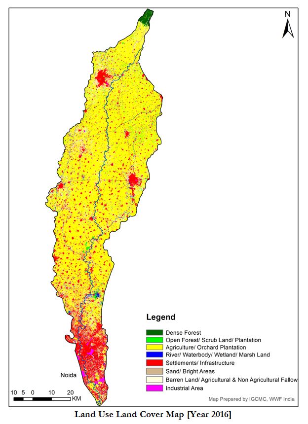
Distribution of Landuse/Land Cover in Hindon Basin [2016]
| S.No. | Class Name | Land Use/Landcover (Sq. Km.) | In %age |
| Class-1 | Dense Forest | 26.04 | 0.435549 |
| Class-2 | Open Forest/ Scrub Land/ Plantation | 89.89 | 1.503514 |
| Class-3 | Agriculture/ Orchard Plantation | 3930.24 | 65.73781 |
| Class-4 | River/ Water body/ Wetland/ Marshy Land | 148.38 | 2.481827 |
| Class-5 | Settlements/ Infrastructure | 889.23 | 14.8734 |
| Class-6 | Sand/ Bright Areas | 98.05 | 1.64 |
| Class-7 | Barren Land/ Agricultural & Non Agricultural Fallow | 767.53 | 12.83783 |
| Class-8 | Industrial Area | 29.3 | 0.490076 |
- Conditions of the tributary rivers Krishni and West Kali are dire, compounding the adverse effects at the basin level.
- Riparian vegetation and flood plain have almost disappeared along the entire length under farms in rural areas and under built encroachments in urban areas [Saharanpur and Ghaziabad]
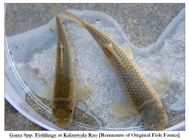
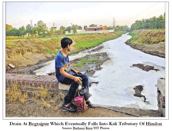
- Industrial pollution as well as significant domestic wastewater from Saharanpur and Ghaziabad has poisoned the river and in turn the basin aquifers. This has not only led to the absence of dissolved oxygen in most stretches of the river but also to the absence of native aquatic fauna in the river. Native fish species, recorded in the District Gazetteers, are no longer found in the river other than depleted populations of stunted pollution tolerant fish unfit for consumption. Riparian biodiversity and other major fauna are now history.
- The pollution of surface and ground waters has resulted in scarcity of potable water and a rising incidence of water borne diseases and cancer.
- The basin is criss-crossed with several irrigation channels and escapes from Upper Ganga Canal which not only irrigate parts of the basin but also transfer Ganga water to the Hindon river. This transferred water is diverted at Ghaziabad through Hindon Cut Canal to feed Yamuna River and thereafter Agra-Gurgaon Canal system. Thus effectively Hindon, for a major part, is not a naturally flowing river but a transfer canal – a hybrid system which leaves it less like a living system and more like a lifeless conduit.
- The current basin economy rests upon massive water imports from the Upper Ganga Canal which supports burgeoning water guzzling sugar cane cultivation which consumes 72% of the irrigation water used in the basin. Were it not for this availability the present cropping pattern could not have come about. There is a huge potential for saving water by adopting more efficient cropping pattern, cropping methods (System of Rice Intensification, Sustainable Sugarcane Initiative, etc) and save water for the river.
- Groundwater exploitation stands at an average 100% and is higher in the areas on the right bank as these are not so well serviced by Ganga Canal.
- While pollution from point sources is a visible enemy with known culprits and known solutions,pollution from the agricultural sector through the overuse of chemical fertilizers and pesticides is washed into the river and seeps into aquifers silently.
- Against the total rainfall endowment of 4156 MCM (Million Cubic Meters) annually the irrigation demand alone is 8000 MCM.
Population of Hindon Basin [2011]
| District | Basin Area (Sq. Km.) | Rural
Pop. |
Urban Pop. | *Basin Pop. | %age Pop. Of Basin |
| Haridwar | 290 | 1,45,221 | – | 1,45,221 | 1.45% |
| Saharanpur | 1802 | 11,72,147 | 10,66,526 | 22,38,673 | 22.40% |
| Muzaffarngr[incl. Shamli] | 2009 | 14,79,782 | 11,91,312 | 26,71,094 | 26.73% |
| Meerut | 321 | 2,11,303 | – | 2,11,,303 | 2.1% |
| Baghpat | 828 | 6,44,362 | – | 6,44,362 | 6.45% |
| Ghaziabad | 422 | 5,43,731 | 31,62,547 | 37,06,278 | 37.10% |
| G Budh Ngr | 303 | 1,59,252 | 2,13,686 | 3,72,940 | 3.77 |
| Total | 5,975 | 43,55,798 | 56,34,073 | 99,89,871 | 100% |
- The estimated domestic water demand is 384 MCM which is <5% of the irrigation water demand. An equal amount is being assumed as industrial water demand
Crop-wise & Dist-wise Basin Irrigation Water Requirement [MCM]
| Crop | Shrnpr | Muzzafarngr | Meerut | Baghpat | Gzbad | GB Ngr | Total [MCM]Crop-wise | %age Irr. Water Crop-wise |
| Wheat | 208 | 235 | 34 | 116 | 99 | 40 | 732 | 9.2 |
| Rice | 300 | 117 | 22 | 21 | 91 | 33 | 584 | 7.3 |
| Sugarcane | 1315 | 2417 | 369 | 1114 | 533 | – | 5748 | 72.8 |
| Others* | 213 | 244 | 76 | 109 | 88 | 64 | 794 | 10.05 |
| Total Irr. Water Basin Dist. | 2036 | 3013 | 501 | 1360 | 811 | 137 | 7894 | 100 |
| %age Irr Water Consumed District-wise | 26 | 38 | 6.3 | 17.2 | 10.2 | 1.7 | 100 |
Approximate Water Budget Of The Hindon Basin [MCM]
| [1] | [2] | [3] | [4] | [5] | [6] | [7] | [8] | [9] |
| Annual
Rainfall |
Surface Runoff To Hindon | GW
Recharge From Rainfall |
Estimated
GW Recharge From Canals Only |
Ganga Water Transfer
to Yamuna Via Hindon |
Irrigation
From GW |
Irrigation
From EYC & Ganga Canal |
Domestic Water
Use |
Industrial Water Use |
| 4156.24 | 968 | 1143 | 981 | No Data | 1839 | 6193 | 384.72 | 400 |
| From Table 33 | From Table 24 | Derived
From Table 19 |
Derived From Table 19 | Derived
From Table 19 |
From Table 30 – Col. [6] | From Table 32 | In line with national figures |
In Ghaziabad and Saharanpur it was observed that construction is merrily taking place in the areas well within the flood disaster zone.


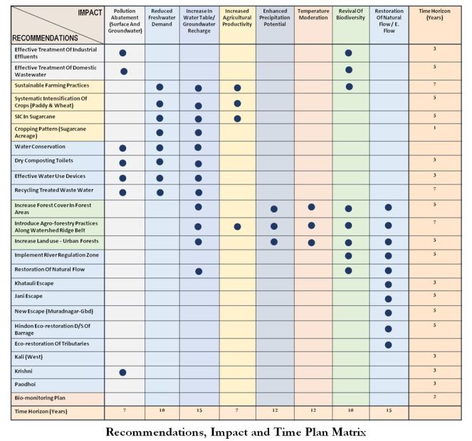
Conservation Plan
7.0 The official approach thus far is to address pollution issues [mainly industrial] and get the Hindon to flow by increasingly bleeding the Upper Ganga Canal.
8.0 River restoration requires formation of a strong basin organization overcoming the cleavages amongst different jurisdictions and departments. It requires raising the water use efficiency of irrigation and other uses, ensuring no polluted water enters rivers and aquifers, recognition and protection of groundwater recharge mechanisms, rejuvenation & protection of wetlands, other water bodies & forests, and enhancement of green cover and restoration of riparian zone to as close to natural conditions as possible. These require a horizon of 15 years with the objective of attaining climate resilience, recouping aquifers, maintaining e-flows and improving water quality to levels which recover healthy aquatic fauna.
9.0 Reclaiming the Hindon’s perennial nature with restoring what may be termed as e-flows or minimum adequate flow [difficult to establish] as a first step is a complex task which may be considered over a long term horizon and which may have political implications. The data provides pointers to the directions to be taken but these require a high level of consensus amongst the stakeholders and a broad program of action. It is also critical to re-examine the current water allocations, revise water allocations accounting for environmental flows requirements and the tradeoffs emerging from these.
Agricultural Pollution
10.0 Most chemical fertilizers and chemical pesticides require large quantities of water for dissolution and uptake by plants. In actuality at most, only about 25% of the applied material is useful, the rest gets washed out in the rainfall runoff to waterbodies, streams and rivers, resulting in surface and groundwater pollution, entering into food chains, as well as overwhelming the aquatic ecosystem.
11.0 Promotion of sustainable farming techniques based solely on increasing organic content in the soil and avoidance of chemical inputs has several benefits including elimination of chemical fertilizers. Similarly, herbs based organic pesticides can substitute for pesticides. These measures would eliminate water pollution from agricultural sources. The sustainable agriculture program has multiple benefits:
- It improves soil health and productivity
- It improves crop resilience to climatic variations
- It reduces water use by almost 50%
- It reduces input cost of the farmer [water, chemicals, labour] enhancing his margins
Irrigation
- Systematic Intensification of Crops [SIC]: This system is increasingly gaining currency on account of its combination of increased productivity along with 30% – 50% reduction in water requirements. This system is proven and needs to be rapidly promoted in Hindon basin and North India in general to reduce groundwater extraction as well as use of fresh Ganga water for irrigation purposes. Agricultural universities need to be pressed into service to train farmers in the technique and support pilot projects in the field.
- Systematic Intensification of Sugar Cane Crop: can help reduce water use in Sugarcane, the most water guzzling crop in the basin. SSI has been successfully demonstrated to enhance yield whilst reducing water requirement by >30%.
- With regards to sugarcane acreage it is recommended that to start with the area under sugarcane in the basin should be frozen to limit groundwater extraction. The discouragement to sugarcane cultivation may be in the form of financial disincentive for sugar factories, incentives for SSI and alternative crops. The number and capacity of sugar mills in the basin should also be frozen and reduced over time so as to act as a disincentive to bring additional area under sugarcane cultivation.
Groundwater Extraction
15.0 Raising the water table is key requirement for restoring the perennial virgin flow in the lean season. As water demand is curtailed in the basin consequent to the measures outlined in the previous sections it would be wise to reduce groundwater pumping and rely mainly on the water imported from the adjacent canal systems thus allowing the water table to build up. This would result in greater base flow. The higher the water table the greater the lean season base flow. Over time, the reliance on imported water should also be reduced.
Forest Cover
- It is established that dense and widespread forest cover can enhance precipitation and moderate temperature. Therefore, it is a prime necessity to improve the quality of existing forest cover as well as enhance the area under forest cover in the basin.
- As a first step the re-densification of the Kaluwala Rao forests on the Shivalik slopes should be taken up on priority. Similarly, other protected/reserve forests in the basin should similarly be addressed in short time frame.
- The increase in forest cover is challenging in view of the unavailability of land in the public domain. The first issue in this regard is the location of forest cover. It is recommended that forest cover be increased in a wide swathe [perhaps 2 km. wide] along the watershed line on both the eastern and western sides.
- Without transfer of land from private hands it is suggested that cultivators located in this wide swathe [2 km wide – see following map] should be incentivized and persuaded to adopt agro-forestry practices. This would require significant hand holding, financial support during transition period, extension services from ICAR Institutes.
National Agro Forestry Policy [2014] Extracts
It is also recognized that agroforestry is perhaps the only alternative to meeting the target of increasing forest or tree cover to 33 per cent from the present level of less than 25 per cent, as envisaged in the National Forest Policy (1988). A major role for agroforestry is emerging in the domain of environmental services. Agroforestry is known to have the potential to mitigate the climate change effects through microclimate moderation and natural resources conservation in the short run and through carbon sequestration in the long run. Agroforestry species are known to sequester as much carbon in below ground biomass as the primary forests, and far greater than the crop and grass systems.

River Regulation Zone [RRZ]
- River Regulation Zone: The draft RRZ is still needs to be urgently notified by the MoWR or MoEF & CC -. It has many beneficial elements which the Hindon Committee would do well to adopt. Foremost amongst these is the space reserved for the river within its once in a 100 years flood line. This buffer should be kept sacrosanct and free from construction activities. Existing constructions within this buffer should be removed over a period of time.
E – Flow
- Detailed database development with regards to groundwater budget, flow measurement at various locations and in various seasons over a prolonged period of, say, 5 years, plus data on imported water and sewage flows would help to build an integrated hydrological model of the system enabling policy interventions.
- It is also suggested that the transfer of Ganga waters to Hindon:
- through Khatauli escape can be withdrawn over a longish time frame as water requirement dips through efficiency gains.
- through Jani Escape may be substituted by a new 10 km channel running in a south-west direction from south of Muradnagar skirting Ghaziabad city on its north.
- The empty beds of these escapes may be filled with Ganga water or local floodwaters or treated wastewaters, separately or in combination and used as 365 days groundwater recharge zones.

23.This would enable almost 90% of the river length [312 km from point of origin] to flow as a natural river without artificial additions to the flow. Only then consideration and estimation of e-flow can take place
- Downstream of Hindon Barrage: This stretch of the river channel needs to be restored to its natural status with revival of its virgin flow, floodplain wetlands, riparian vegetation and flood plain buffer. On account of low flows there has been an accretion of silt deposition which may have to be removed.
- Tributaries: Without addressing the tributaries [Kali West and Krishni as also smaller streams such as Paondhoi and Dhamola] the best results would not be obtained. Some of the above stated remedial measures may have to be directly applied to the tributary streams as well.
Bio-monitoring Plan
- Biological indicators of a healthy river would have to be monitored on a regular basis. The return of micro-organisms, original fish species, amphibians, etc. would demonstrate the effectiveness of the river conservation plan.
- The bio-monitoring plan would have to be elaborated for different reaches of the river as well as for different seasons. This would have to be a separate detailed exercise which would be accomplished by trained local groups [NGOs, students, academics]. The field observations would be fed into a central online database for obtaining a holistic picture of the basin level improvements.
- Governance Issues: Hindon basin is possibly just the right scale at which the first bottom up basin management model in the country can be worked out. What is being recommended is a landscape approach at the basin level which requires a certain amount of erasure of jurisdictional and sectoral boundaries. This requires a high degree of coordination amongst all stakeholders [official, private as well as individuals]. The individual administrative units, line departments, research institutions and NGOs have to work hand in hand towards common goals. This requires:
- A legally empowered bottom up Hindon Basin Organization [HBO] which must be duly supported by the State Govt
- The HBO must also include, other than the conventional participants, the Forest Dept., the State Groundwater Board, agricultural institutes as well
- The HBO would need to carry out a massive effort in spreading awareness and influencing the behaviour of the many actors in the basin
- The HBO could make use of the structure of District Committees mandated under the Ganga Authority Notification of Oct 2016.
- The network of structure would need to start from gram sabha to block committees to district committees.
Manu Bhatnagar (manucentaur@hotmail.com)

One thought on “Hindon River Gazetteer: An Introduction”