Western Ghats

Yettinahole Diversion: An imprudent, Rs.100 Billion proposition

Background Karnataka has been mulling over diverting waters of the west flowing rivers to the east for many years. Netravathi-Hemavathy Link was proposed by the National Water Development Agency (NWDA) as a part of peninsular component of the River linking project. In the meantime, Karnataka appointed a committee under the leadership of Dr. G. S. Paramshivaiah which worked on a plan to divert waters from west-flowing rivers including Netravathi to 7 districts of Bayaleseeme region including Kolar, Bangalore, Tumkur, Ramanagara, Chikmagalore, Chikkaballapur, etc.

River Gundia, formed by Yettinahole and other streams which are to be diverted by Yettinahole Diversion Project Photo: SANDRP

But currently, the Karnataka Government is seriously considering Yettinahole Diversion Project which plans to divert head waters of the Gundia River ( a tributary of the Kumardhara, which is a tributary of the Netravathi) in the west and transfer this water to the other end of the state, in the east. It has been reported that tenders for this project have been floated already. Its Project Report (June 2012 version) is titled as ‘Scheme for diversion of flood water from Sakleshpura (West) to Kolar/ Chikkaballapra Districts (East)’.

NOTE, SANDRP: 4 Sept 2014:

Following the efforts of several groups, including SANDRP, Yettinahole Project was strongly opposed, though advocacy and on-ground struggle. In response, the Karnataka government has made substantial changes in the DPR of the Project which was completed in late 2013/early 2014. Several elements have been changed cosmetically, to counter our valid points, thus vindicating the points raised below. SANDRP has published a detailed assessment of this DPR. It can be found here: Yettinahole DPR: New Avtaar, Old Problems.  https://sandrp.wordpress.com/2014/09/18/yettinahole-diversion-dpr-new-avataar-old-problems/

~~

In Karnataka Budget Part I, February 2012, Rs 200 Crores have been allocated for making DPR and initial works while Rs 2670 Crores have been sanctioned and Rs 850 Crores allocated in 2013-14 for lift works upto Harvanahalli in Sakaleshpura.[1] All these allocations have been made without a Detailed Project Report, cost benefit assessment, options assessment or environmental and social appraisal of the scheme, or any statutory clearances. This is highly problematic as this assessment indicates that this energy intensive project will have profound impact on Western Ghats biodiversity, wildlife and livelihoods

______________________

SANDRP analyzed the Project Report (PR) which was obtained under RTI by Mr. Kishore Kumar Hongadhalla, who had specifically asked for a ‘Detailed’ Project Report. The total cost of the project as per the PR is 8323 Crores. But the estimate does not include many costs like Rehabilitation and Resettlement (R & R), complete land acquisition, construction of reservoirs on Palar Basin as mentioned in the Project Report, pipeline to 337 tanks, Forest NPV, etc. If these are included, cost of the project will certainly go beyond Rs 10000 crores /Rs 100 billion.

______________________

Purpose of this scheme is stated as drinking water supply to Kolar and Chikkaballapur Districts. However, analysis of the Project Report indicates that drinking water to be supplied to Kolar and Chikkaballapur will be a bare 2.81 TMC or 11.7% of the 24.01 TMC diverted. If water is supplied to Bangalore (urban) as is said in the Budget, but not the Project Report, then water supplied to Kolar and Chikkaballapur will be even less, possibly nil.

_______________________

Analysis of the Project Report and site visits to Yettinahole and surrounding catchments indicate that this project is economically, socially and technically inviable and will have a massive impact on the ecology of the Western Ghats and eastern plains. The analysis also assesses the claim of providing drinking water to Kolar and Chikkaballapur: whether it is viable, desirable and optimal option.

I.                    The Project

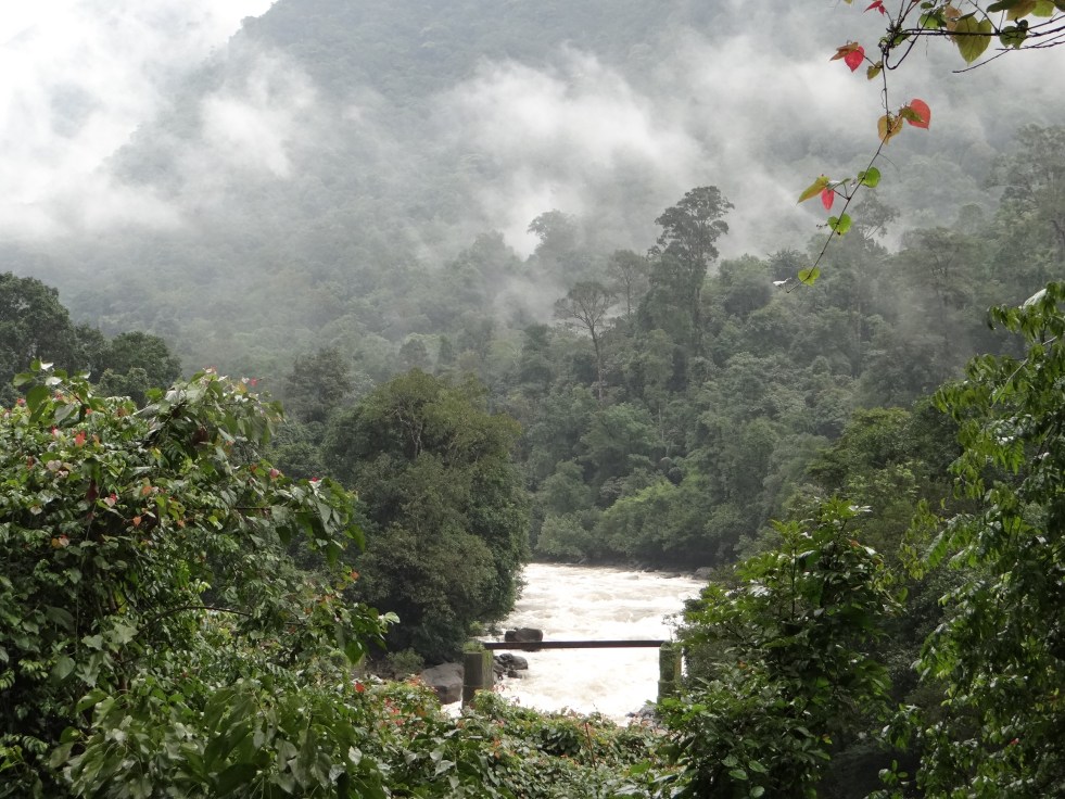
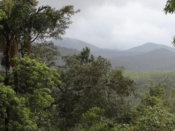
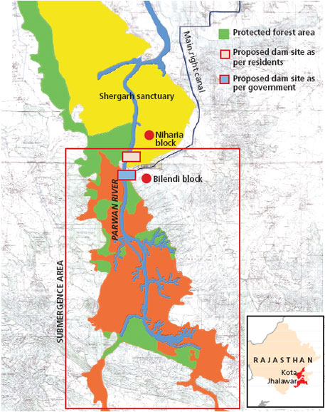
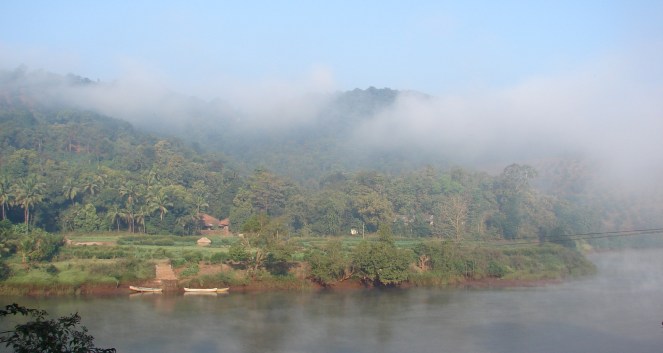
The project involves construction of 8 dams  in 2 phases at the head waters of Gundia River basin, a tributary of Kumaradhara, which in turn is a major tributary of the West flowing Netravathi River, the lifeline of Mangalore and Dakshin Kannada districts. The Project Report insists on calling these as weirs, but the drawings[1] indicate the height these dams as 15 meters from deepest foundation, making them large dams, as per the definition of International Commission on Large Dams {ICOLD}.

Dams and rising mains in Western Ghats: 2 dams are planned across Yettinahole stream, 2 on its tributaries, 2 across Kadumanehole stream, 1 across Kerihole stream and 1 across Hongadhalla stream. All these streams are rivulets which join at various points to make river Gundia. Rising mains (large pipelines that transport water under pressure) from these projects will pump water into 3 delivery chambers. From the delivery chambers, water will be lifted to an intermediate pumping station at Doddanagara in Sakaleshpur. From Doddanagara, water will be lifted again and conveyed to Delivery chamber 4 located near Harvanahalli in Sakaleshpura.

Schematic Representation of pumping involved in Yettinahole Diversion Project. From: KNNL Project Report Volume I)

233 kms long Gravity canal: From Harvanahalli, water will flow through a gravity canal of 233 kms (Proponent says 250 kms in MoEF Meeting) in length to Tumkur.

Devaranya Durga Reservoir: From Tumkur, again the water will be lifted through a rising main and will culminate into a reservoir to be built at Devaranyadurga. This reservoir will have a height of 68 meters and gross storage capacity of 11 TMC. It will submerge approximately 980.4 hectares of land, including forests.

When this project was discussed in the Expert Appraisal Committee meeting of the Ministry of environment and Forests, the proponents have claimed that Devaranyadurga Reservoir will submerge 1200 hectares of land, of which 50% will be forest land and will also submerge at least 2 villages.[2]

From here, two rising mains of 80 kms and 55 kms will again lift and convey water to Chikkaballapura and Kolar respectively. In Chikkaballapura and Kolar, the rising main will feed various streams and rivers and will have dedicated pipelines to feed Minor Irrigation (MI) and Zilla Parishad (ZP) tanks.  Scheme envisages feeding 198 tanks in Chikkaballapur and 139 tanks in Kolar District.

The scheme envisages providing 14 TMC for Hassan, Chikkamagalore, Tumkur and Bangalore rural and 10 TMC for Kolar and Chikkaballapur, through the dam at Devaranyadurga. So, the claims that Kolar and Chikkaballapur will get 24 TMC water is false. The project report is titled ‘Scheme of diversion of floodwaters to Chikkaballpur and Kolar’ but these districts seem to be getting less than 50% of the diverted water. As we see in later sections, of this 10 TMC barely 2.81 TMC is earmarked for drinking water supply.

Locations of Dams/Weirs of Yettinahole Project SANDRP

New Reservoirs planned

  • Chikkaballapur District:
    • New reservoir across Kushavathy River at Gudibande.
    • A new reservoir At Timassandra across Palar river
    • Kolar District: Bethmangala Tank to be used as an important reservoir
    • At Tanadihalli on Palar River North to store 2.20 TMC water

Electricity needed: As per the project Report, the scheme will require massive 370 MW of electricity.

Yettinahole River Photo: SANDRP

Volume of water to be diverted: 24.01 TMC water is proposed to be diverted between June-November from a catchment area of 89.66 sq kilometers (8966 hectares). It has to be noted that 24.01 TMC water is available at 50% dependability. So, in 50% years under consideration, 24.01 TMC volume would not be available for diversion. The structures and conveyance system has also been designed at 50% dependability. This may imply several things:

  • The scheme can work beyond June-November
  • The scheme can divert more than 24 TMC waters from Yettinahole
  • The scheme can be used later for diverting waters of other rivers.

This further warrants a serious look at the entire project.

II.                  Environmental Impact of the Project on Western Ghats and other regions

Impact on Forest Land and Wildlife

The exact extent of revenue, private, agriculture and forest land required for the scheme is not known from the PR. The report (Volume II, Estimates) mentions a head ‘clearing of thick forest by burning’ under costs for laying rising mains from dams to pumping stations. According to these estimates, 107.27 hectares of thick forests will have to be cut or burnt for the rising mains alone.

Yettinahole Catchment and surrounding forests Photo: SANDRP

The forest land involved in submergence of dams, approach roads, workers colonies, muck dumping sites, electrical substations, mining of materials for the project, destruction due to blasting, etc. will be additional. The project report does not provide any of these details.

Most of the forests in the vicinity of Yettinahole, Kadumane hole, Kerihole and Hongadhalla are not only reserved forests, but important wildlife corridors. When IISC studied this region  it recorded  119 trees species,  63 shrubs and climbers, 57 herbs and 54 pteridophytes[3], 44 species of butterflies, 4 dragon and damsel flies, 23 species of amphibians including the threatened Gundia Indian Frog, 32 reptiles, 91 birds and 22 mammals including Tiger, Lion Tailed Macaque, Elephant, Slender Loris and Gaur.

Elephant dung at a KPCL survey in Hongadhalla region, to be affected by Yattinahole Diversion Project. Photo: IISc

The region is witnessing rising man animal conflicts due to destruction and degradation of habitats. During 2002-2012-13, 34 people have died and 17 elephants have been electrocuted in Sakaleshwar Taluk alone (http://www.thehindu.com/news/national/karnataka/elephant-encounter-is-an-everyday-affair-for-them/article4874172.ece). The Karnataka Elephant Task Force has acknowledged the impact of mini hydel projects in Sakaleshpur on Elephant corridors and has given strong recommendations about reviewing clearance and canceling projects which affect elephant distribution areas negative and do not comply with existing laws.

Dams, roads, blasting, muck disposal, workers colonies, sub stations, increased traffic in this region will have a pronounced impact on the wildlife, including the elephants. Any more stress on these regions will precipitate in furthering of conflicts and disturbance.

Environmental Flows As per the working tables, all inflow from the headwaters will be diverted for the most of June, parts of July and August and all of September, October and November. The streams will be completely dry for most days during this period. (Project Report Vol. I, Page A 21) There has been no provision made for environmental flows. This will be extremely damaging for the downstream ecology, wildlife and forests. This issues needs urgent attention and studies.

The scheme may look inviable if eflows are released, as they must be, from the dams/ dams into the downstream river.

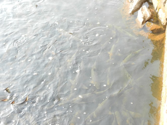
Impact on fish assemblages and fish sanctuaries Kumaradhara and Netravathi are home to some rare community conserved fish sanctuaries. Fish sanctuaries exist at Kukke Subramanya, Nakur Gaya and Yenekal, all of which are downstream from the proposed diversion. The fish assemblages, their feeding and breeding patterns are highly affected by flow. Any drastic changes in flow regime will affect these species.

Gundia River itself has several rare and endangered fish species. 3 new fish species have been discovered and 1 rediscovered in Kumardhara river basin between 2012-13[4]

Congregation of the engandgered Mahseer fish at Yenekal Fish Sanctuary, Kumaradhara RIver downstream proposed Yettinahole diversion. Photo: SANDRP
Congregation of the endangered Mahseer fish at Yenekal Fish Sanctuary, Kumaradhara River downstream of proposed Yettinahole diversion. Photo: SANDRP

Blasting using dynamite The project report and estimates state that hard rock will need to be blasted extensively with dynamite. Dynamite blasting will have severe negative impact on the wildlife of the region. Blasting also has documented harmful effects on groundwater aquifers and can affect the existing water sources and water holes of the wildlife.

Muck generation and disposal As per the project report, muck generated for laying the rising mains alone will be to the tune of 13,02,837 cubic meters. All of this muck will be generated close to the rivers, in forest areas. Dumping of this muck will have a huge negative impact on water quality, forests and wildlife. Uttarakhand disaster in June 2013 highlighted the how muck is routinely disposed into rivers and the havoc this causes in the downstream.

Additional muck will be generated during dam/ dam construction, approach, colonies, substations, etc. The impact of this will be compounded.

Approach roads, workers colonies All the dams/ dams, rising mains, electric substations will require approach roads which will pass through forests, further impacting forests and wildlife. Workers colonies and waste disposal will again have additional impacts on the region.

Diverting entire rivers and not just floodwaters The scheme purports that it is diverting only the flood waters of these rivers. However, the yield of all the rivers at 50% dependability between June-November is 28.94 TMC, out of which 24.01 TMC will be diverted. This leaves just 4.93 TMC for the downstream. This is maximum diversion of the rivers and not just ‘flood waters’ or overflow.

Also, even when rainfall is low, the scheme will divert all available water till it gets its share of 24.01 TMC, which will then dry the rivers completely in the downstream.

These are monsoon-fed rivers. Only source of water for these rivers is the monsoon, which also replenishes groundwater, which constitutes the base flow in non-monsoon months. This diversion in monsoon months will have a huge impact on water availability in non-monsoon months also in these rivers and which in turn will have impact on the biodiversity and livelihoods.

III.                Supposed Beneficiaries: Contradictions between Budget and Project Report

As stated (verbatim) in the Project Report, following are the beneficiaries of the project (Project Report Volume I:  Section 4.7, Page 52)

  • Selected parts in Hassan District
  • Selected towns in Chikmagalur, Chitradurga by feeding Vedavathi river
  • Tumkur, Madhugiri, Pavagada and Koratagere Taluk
  • Chamrajsagar reservoir
  • Water to Devanhalli Industrial Area
  • Augmentation of Hesarghatta tank
  • Water to Chikkaballpur and Kolar District

In addition, water will be used to rejuvenate Rivers like Arkavathy (Cauvery Basin), Palar, (Independent basin) Jayamangli, Kushavathy, Uttara and Dakshin Pinakini, Chitravathi and Papagni rivers (Pennar Basin) (Project Report Volume I: Section 4.9, Page 52)

The project report makes no mention of supplying water to Bangalore urban area or BBMP (Bruhut Benguluru Mahananagara Palike). However, the Karnataka Budget 2012-14 specifically mentions providing water to these areas.

How much water will this be? What are the options of water supply to Bangalore? If water is supplied to voracious Bangalore and Devanahalli Industrial area, will there actually be water for Kolar, Chikkaballapur and other drought affected areas?

River Rejuvenation: Long distance transfer of water involving huge ecological, social and financial costs seems to be a poor way of rejuvenating rivers. Experts claim that rejuvenating rivers like Arkavathy can be achieved with rainwater harvesting, demand side management, pollution control and releasing treated water in rivers like Arkavathy and Vrishabhavati, not interbasin transfers.

Priority to Drinking water for Kolar and Chikkaballapur? Doesn’t seem so

Of the 10 TMC to be provided to Kolar and Chikkaballapur, the Project Report mentions that drinking water needs of Kolar and Chikaballapur Districts are 6 TMC. Rest of the 4 TMC will be used to fill up 337 MI and ZP Tanks in the districts.

The project report proposes to fill these tanks at 60% live storage capacity. According to Table 2 and 3 in Project Report Volume 1, Page 7, this proposed 60% filling requires 4.08 TMC water in Chikkaballapur District and 3.11 TMC water in Kolar District. So together, as per the Project Report, the proposed filling of MI tanks needs 7.19 TMC water.

This leaves bare 2.81 TMC water for drinking purposes of these districts!

If out of 24.01 TMC transferred, only 2.81 TMC will be supplied for drinking water to Kolar and Chikaballapur, this is clearly not a drinking water supply project for these districts, as claimed.

So undecided is the Project Report about supplying drinking water that it says further “alternatively if water is to be used fully for drinking, then it will require 4 new storage tanks”. The Project Report does not conclude on whether these tanks will be built.

IV.                Escaping Environmental Clearance by false claims

This scheme will:

  1. Destroy hundreds of hectares of pristine biodiversity rich and unexplored forests, wildlife habitats, habitats of critically endangered species, reserved and protected forests in the Western Ghats
  2. Affect downstream flows and riverine ecology of the Gundia, Kumaradhara & Netravathi Rivers
  3. It will submerge nearly a 1200 hectares of land, 50% forest land and 2 villages  for reservoir to be constructed at Devaranyadurga
  4. Main gravity canal which will be 250 kms long and 16 mts wide (as stated in EAC meeting by proponent) will require a minimum of 400 hectares of land
  5. It involves Interbasin water transfer, which is not prudent or viable as per the Western Ghats Expert Ecology Panel Report

Clearly, the scheme requires detailed scrutiny for its impacts by undergoing participatory environment and social impact assessment and undergoing a thorough Environmental Appraisal.

The scheme has escaped this by wrongly claiming that it is a purely drinking water supply scheme. The proposal was considered by the Expert Appraisal Committee of the MoEF in its 63rd meeting in October 2012. In the meeting, the EAC noted that ‘there appear to be some environmental and R and R issues which should be addressed” but recorded its inability to consider this project as drinking water projects do not fall in the purview of EIA Notification 2006.

The minutes note that: “The project neither proposes any hydro-electric power generation component nor comprises of any irrigation component and thus has no command area.”

However, this is a wrong claim for the following reasons, among others:

A. Irrigation Component: The EAC says that there is no irrigation component. However, the command areas of 337 minor irrigation tanks in Kolar and Chikkaballapur, as mentioned in the Project Report (Voulme I, Annex 3) come to 29,182 hectares, all of which will benefit from the project. This is higher than command area of 10,000 hectares; hence the project comes under the purview of EIA Notification 2006 and will have to be considered for Environmental Clearance by Expert Appraisal Committee of the MoEF under EIA notification 2006.

B. Hydropower Generation: The project claims that it can generate 125-150 MW of power   through gravity canals. Location details are also made available in the Project erport (Page 59, Volume I). As the total capacity is higher than 25 MW, the project comes under the purview of EIA Notification 2006 and will have to considered for Environmental Clearance by the Expert Appraisal Committee of the MoEF.

It is clear that the EAC’s decision that the project does not fall under the purview of EIA notification is incorrect technically. Furthermore, it is unacceptable to exclude any large dam or project which has such significant impact on land and ecology from the purview of EIA notification and EIA notification needs urgent amendment.

A joint letter has been issued by more than 14 organisations and individuals across Karnataka, urging the MoEF to appraise this project completely. Signatories include former Forest Advisory committee Member Dr. Ullas Karanth, Praveen Bhargav from Wildlife First, institutes like IISc, amongst many other. (https://sandrp.wordpress.com/2013/09/10/complete-appraisal-needed-for-yettinahole-diversion-project-letter-to-moef/) Reports on the Submission: www.dnaindia.com/bangalore/1889546/report-govt-hiding-facts-on-yettinahole-say-activists,http://articles.timesofindia.indiatimes.com/2013-09-12/mangalore/42007183_1_yettinahole-project-chikkaballapur-districts-water-problem,http://articles.timesofindia.indiatimes.com/2013-09-13/mangalore/42039865_1_water-problem-drinking-water-supply-scheme-dams)

V.    Yettinahole & Gundia HEP (Phase I: 200 MW, Phase II: 200 MW) overlap

While the Karnataka Neeravari Nigam Limited is making Project Reports, DPRs and has even earmarked budget in 2013-14 session, Gundia HEP has been planned on the same catchments and same rivers by Karnataka Power Corporation Limited (KPCL).

Gundia HEP proposes to divert flows from Yettinahole, Kerihole, Hongadhalla and Kadumanehole (Phase II) through maze of tunnels to generate 200 MW power in phase I and 200 MW in Phase II. KPCL has completed an Environment Impact Assessment for this project (which is of a poor quality). KPCL has also made presentations to the Western Ghats Expert Ecology Panel about the project.

Power generation is based on water yield from the catchment, which will be intercepted by Yettinahole Diversion Project. In fact, dams of Gundia HEP and Yettinahole HEP are placed close to each other. Both the projects, by the Karnataka Government are working in isolation and cross purposes as if the other project does not exist.

Locations of weirs and dams of Gundia and Yettinahole Projects SANDRP
Locations of weirs and dams of Gundia Hydel Project (GHEP) and Yettinahole Projects SANDRP

Shockingly, both projects have also been considered within three months by the EAC of the MoEF for appraisal. The Expert Appraisal committee of the MoEF in its 59th Meeting in July 2012 considered Gundia HEP and in its 63rd Meeting in October 2012 Yettinahole Diversion Project. EAC has recommended Environmental Clearance to Gundia (another wrong decision), whereas it has indicated that Yettinahole Diversion Project does not require an Environmental Clearance. In doing so, the EAC has not considered that both these projects plan to divert waters from the same catchments. This also says a lot about application of mind by the Expert Appraisal Committee. At the same time, it also raises questions about the coordination and work of Karnataka Government.

VI.                Options Assessment

The project raises pertinent questions about water management and water sharing: Is diverting water from west flowing rivers, at a huge social, ecological and economical costs the only option to provide drinking water to Kolar and Chikkaballapur regions? Is there no other optimal solution? Did the Karnataka government undertake an options assessment study to arrive at such a conclusion?

An analysis of rainfall for the one hundred years between 1901-2001 indicates that rainfall in Kolar and Chikkaballapur has not shown significant fall.

Annual Rainfall in Kolar District during 1901-2001 Data Source: IMD, Graph: SANDRP
Annual Rainfall in Chikkaballapur District during 1901-2001 Data Source: IMD, Graph: SANDRP
Kolar
Annual Rainfall in Kolar District during 1901-2001 Data Source: IMD, Graph: SANDRP

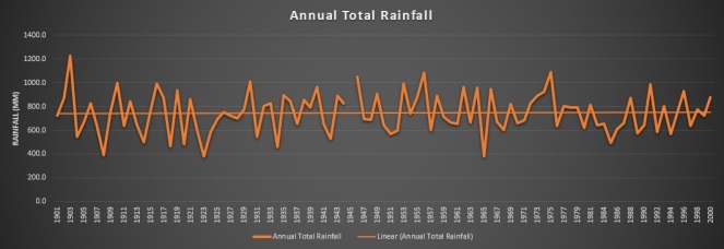
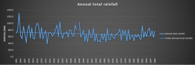
Kolar District, especially was once rich in water tanks and local harvesting measures. Average rainfall in Kolar is 750 mm, which is not low. According to the Karnataka Gazetteer, the district had, in 2012, only 2,095 tanks from the 35,783 tanks in 1968. Most of the tanks were a victim of siltation, encroachment and neglect.[5] Organisations like Gramvikas and Dhan Foundation have demonstrated how desilting and management of tanks in Kolar can secure water for drinking as well as for irrigation, cattle rearing, etc.[6] Some groups have worked on highlighting the positive impact of applying reservoir silt to crops, as an option to fertilisers and to facilitate desilting. Indian Institute of Sciences (IISc) has demonstrated that desilting these tanks in Kolar can not only help water security, but it can also reduce the incidence of fluorosis.[7]

River Rejuvenation: Long distance water diversion is not an answer to drying and dying rivers Rivers like Arkavathy are dying due to persistent pollution from industries and urban areas and also due to catchment degradation. How will waters from Yettinahole revive this situation? Local efforts, sound environmental and water governance however, can help this situation. But this is not being explored sufficiently.

_____________

Long-distance water transfer: problems and prospects

(From: Prof. Asit Bisaws, Long-Distance Water Transfer United Nations University, 1983)

If many of the past and present experiences on long-distance water transfer are reviewed critically, the following major issues emerge:

(1)                Mass transfer of water is often justified by considering only the direct cost of transporting water. Seldom are the values of services foregone by the exporting region due to reduction of their water availability, i.e. the opportunity costs of exported water analysed.

(2) Various other feasible alternatives to interbasin water transfer are often not investigated. There is a tendency within the engineering and economic professions to opt for technological solutions-“soft” options tend to be neglected. Since water resources development is dominated by these two professions, there is a tendency to opt for technological fixes before all viable alternatives are explored. Among possible options are:

-more efficient use of available water;

-re-use of waste water;

-better management of watersheds;

-improved integration of surface and groundwater supplies;

-changing cropping patterns.

______________

Climate Change and Western Ghats:

Climate change Assessments like 4X4 Assessment of INCA have indicated that rainfall in southern Western Ghats, which also includes Netravathi and Gundia catchment is expected to fall in the coming years. This will affect water resource projects, crops, fisheries, etc. (https://sandrp.wordpress.com/2013/07/26/climate-change-in-western-ghats-4×4-report-and-beyond/)

We cannot ignore these signals while planning expensive schemes at the cost of ecology and sociology which might prove to be inviable in a few years in face of climate change. Keeping all these factors in mind Karnataka needs to proceed extremely cautiously on Yettinahole diversion scheme.

_______________

VII.              In Conclusion

Environment and Social Assessment are basic prerequisites for a project of such massive dimensions.

All in all, looking at several serious issues associated with Yettinahole Diversion Project, it is urgently needed that:

  1. Project should undergo complete  Environment appraisal and Clearance scrutiny, as laid down by the  EIA notification, 2006
  2. Recommendations of the Western Ghats Expert Ecology Panel about avoiding inter-basin transfers in the Western Ghats should be adhered to.
  3. Options Assessment and cost benefit analysis, including the ecological costs of the diversion should be carried out and put in public domain.
  4. Downstream affected communities, including cities like Mangalore and estuarine fisher folk should be consulted during public hearings.
  5. Unbiased assessment about the water stress in Kolar and Chikkaballapur should be carried out with members from groups which have been working from the region, to evolve a holistic water management policy for the region.
  6. Options for reviving rivers and tanks in Kolar-Chikkaballapur need to be explored using traditional and appropriate technology practices. Appropriate cropping pattern and cropping methods should be a part of this exercise.
  7. A review of rain water harvesting, efficient water supply, demand management, lake revival, groundwater recharge, grey water and sewage recycling for cities including Bangalore should be carried out prior to allocating more water from distant sources to such cities.
  8. A democratic bottom up exercise has to be taken up on such proposals both in the Western Ghats areas as well as the projected benefiting areas.

It will not be the interest of the ecology in Western Ghats, Eastern regions or communities in Dakshin Kannada, Hassan, Kolar, Tumkur, Bangalore and Chikkaballpur if a project of such massive proportions, with devastating social and environmental impacts is taken up for short term political or financial gains, bypassing proper credible appraisal and democratic decision making.

Kolar and Chikkaballapur regions have been facing severe water crisis, leading to hardships to local communities. But, for a long term and sustainable solution to these problems, Yettinahole Diversion does not look like a viable option, we do not even know how much water will reach these regions. But the project has the potential to exacerbate ecological degradation, fuel man animal conflicts and further water conflicts between regions.

Drought affected regions may have better options, including better operation and maintenance of existing water infrastructure, more appropriate cropping and water use pattern, revival of existing water harvesting structures, recycle and reuse of water, among others. Attention needs to be paid to these options, rather than ‘diverting’ it.

Hidden costs of projects like Yettinahole Diversion are too big to be actually hidden.

-Parineeta Dandekar, SANDRP  (parineeta.dandekar@gmail.com)


[1] Volume II, Part B, Estimates, Section: Estimates for implementation of the scheme: Drawings

[2] Minutes of the Meeting, 63rd EAC Meeting, MoEF held on 12-13th October 2012. Agenda Item 2.11 (B)

[3] Pteridophytes are plants from the fern family that reproduce by spores.

[4] http://www.deccanherald.com/content/264870/researchers-stumble-species-fish.html, Ichthyological Exploration of Freshwaters, Vol. 23, Number 4

Dams · Ministry of Environment and Forests

Open letter to Rahul Gandhi as he lays foundation stone of Parwan Dam: A Dam meant for thermal power projects

Reports[1] indicate that Congress leader Rahul Gandhi is to lay foundation stone for the controversial Parwan Irrigation Project in Jhalawar district in Rajasthan (see the map above, taken from Down to Earth), before speaking at public meeting in Baran district on Tuesday, Sept 17, 2013. Detailed analysis of official documents and other reliable accounts indicate that this unnecessary dam is seemingly being pushed to supply water to some of the proposed thermal power projects in Baran and Jhalawar districts.

Image

The project will require 12248 ha of land including submergence of massive 9810 ha of land as per conservative government estimates, displacing about 100 000 people[2] from at least 67 villages of Baran and Jhalawar districts in Hadauti region of Rajasthan. It will require at least 1835 ha of forest land, and will affect at least 2 lakh trees only on this forest land, lakhs of trees on non forest land will also stand destroyed. Most of the 1.31 lakh Ha of land in Baran, Jhalawar and Kota districts that is supposedly to get irrigation is already irrigated. These districts have average rainfall of 842 mm (Baran[3]), 923.5 mm (Jhalawar[4]) and 804 mm (Kota[5]), which is high by Rajasthan standards. If there is adequate harvesting of this rainwater, groundwater levels would certainly rise and remain sustainable with appropriate cropping pattern. This has happened in neighbouring Alwar and Jaipur districts.

This Rs 2000 crore dam with huge impacts is certainly not required for this purpose.

From all accounts, in reality the dam seems to be pushed for thermal power projects like the 1320 MW Kawai coal based thermal power project of Adani[6], 1320 MW coal based Chhabra[7] thermal power project of Rajasthan Rajya Vidyut Utpadan Nigam Ltd and the 330 MW gas based thermal power project of RRVUN at the same location. Very strangely, these projects applied for environmental clearance based on water supply from Parwan dam, even when Parwan dam does  not have all the required statutory clearances, and when work its yet to start. The MoEF should have refused to sanction these thermal power projects before Parwan dam was in place.

This action of the MoEF speaks volumes about poor environmental governance due to which the TPS were cleared based on water from a project that is yet to see even foundation stone or all necessary clearances! The allocation for thermal power projects has increased[8] from earlier 40 Million Cubic meters (MCM) to 79 MCM to 87.8 MCM and this is likely to increase further considering these allocations did not take into account the transmission and evaporation losses.

Manipulated clearance process In fact the Parwan dam still does not have all the necessary statutory clearances. A quick look at the way Parwan got various clearances:

Þ    Environmental Impact Assessment From the minutes of the 40th and 45th meetings of the Expert Appraisal Committee on River Valley Committee held in August and December 2010 it is clear that the EIA of the project did not have: Full social impact assessment, Full R&R Plan with Categories of Project affected persons and land for each category, Proper Dam break analysis, proper command area development plan with cropping pattern or necessary irrigation intensity (Only 14% kharif irrigation intensity provided as noted by EAC) and drainage plan, muck disposal plan. The basic facts in the EIA were wrong and the EAC should have rejected the EIA.

Þ    Contradictions in EIA The EIA is full of contradictory information. For example it says the forest land coming under submergence is 1608.59 ha when the FAC form A[9] says that submerging forest land is 1731.48 ha. This is a very big difference by any standards.

Þ    R & R Plan Firstly, there is such huge difference in the figures of displaced and affected people in various documents; it is clear there has been no credible social impact assessment. For example, EAC notes that 2722 houses to be submerged, 3002 (2142 in FAC factsheet in 0413) families to be affected, of which 461 tribal families. No R&R for non tribal families, which is completely unjust. Even for the tribal families there is no adequate provision of agricultural land. FAC sub committee accepts: “Most of these families do not belong to the notified Scheduled Tribes and also do not have any documentary evidence to prove that they are in possession of the forest land for a continuous period of minimum 75 years.” So most of the people will not even be eligible for resettlement or rehabilitation.

Þ    How many people are affected? About 1401 families with population of 8650 persons will be displaced fully while 741 families with 4172 persons will be displaced partially. The ST population comprises 340 families with population of 1524 persons fully displaced and 121 families population 882 persons are partially displaced. However, independent sources are saying that the project will affect more than a lakh of people. This is a huge difference. Track record of past projects shows that official figures are always gross under estimates.

Þ    EAC recommendation However, even when the responses to EAC’s fundamental concerns were not available, EAC recommended clearance to the project in December 2010. This showed how the EAC basically works as a rubber stamp.

Þ    Environment clearance After EAC’s recommendation, the MEF is supposed to issue Environmental clearance. However, a visit to MEF website[10] on September 16, 2013 shows no information about clearance to the project. We learn from other sources that the MEF issued clearance to the project in 2011, but since it is not put up on the MEF website as required under EIA notification and NGT orders, the project will remain open to legal challenge with 30/90 days of MEF putting up the clearance letter on MEF website.

Þ    Wildlife clearance The Standing Committee of the National Board of Wildlife in its 22nd meeting[11] held on April 25, 2011 considered the project. This was the infamous meeting[12] chaired by the then Union Minister of state (Independent Charge) of Environment and Forests Jairam Ramesh pushed 59 projects in two hours (average two minutes per project). He reportedly[13] said later that this was done under pressure, but the damage was done.

Þ    Dr M.K. Ranjitsinh[14] and Dr Divyabhanusinh Chavda[15] submitted dissent notes, but the minister had predetermined objective and did not listen to any argument. The NBWL decided to clear the project even without knowing if the Shergarh  wildflife sanctuary will be affected, how much water the downstream river will need, what will be the impact of the project on Jawahar Sagar Sanctuary, Rana Pratap Sagar Sanctuary or Chambal River Sanctuary or the project even had done basic options assessment or impact assessment.

Þ    Location with respect to Shergarh WLS One of the key issues about this project is the location of the project with respect to Shergarh Wild Life Sanctuary. As noted by the FAC sub committee, the Parwan Doob Kshetra Hitkari and Jangal Bachao Samiti has been saying that the dam site is right inside the Sanctuary. However, if the project were to affect the WLS, it would require a Supreme Court clearance. To avoid this, manipulations have been going on.

The Site Inspection Report[16] of Forest Advisory Committee noted this issue and conducted a joint inspection in June 2012. The SIR said after this exercise that the proposed dam is 150 m in the upstream of the boundary of the WLS. However, the Parwan Doob Kshetra Hitkari and Jangal Bachao Samiti have contested this conclusion and said there was manipulation in this exercise.

But the EIA of the project, as noted by the 40th and 45th EAC meeting said that the project is five km away from the Shergarh WLS (this itself shows how poor is the EIA and how poor is the appraisal by EAC. Shockingly, even the Environment Clearance letter of 2011 also reportedly says that the project is 5 km away from the WLS, another reason why the EC will remain open to legal challenge.) In June 2013 there was another attempt at resolving this dispute, but again due to heavy rains could not be resolved. Funnily, the NBWL, which should be most concerned about this issue, has shown no concern. Until this issue is satisfactorily resolved, the project cannot go ahead, it will remain open to legal challenge.

Þ    Recommendation of 25 cusecs release The NBWL condition that 25 cusecs (cubic feet per second) water should be released for the environment is not based on any assessment of water requirement for the river and biodiversity in the downstream, since such an assessment has never been done. It seems like another manipulation, based on the fact that Shergarh weir, 10 km downstream from the dam site, has storage capacity of 16 MCM, which is equal to release of 25 cusecs water!

Þ    Gram Sabha resolutions The FAC factsheet[17] agrees that there are contradictory gram sabha resolutions, one set against the project and another submitted by the project authorities in favour of the project. The resolutions submitted by the opposing committee, which is without vested interests, is likely to be correct. There should be an inquiry about the correctness of the gramsabha resolutions by an independent body.

Þ    Forest Advisory Committee The FAC considered the project in its meetings in Sept 2012 and April 2013 and recommended clearance in April 2013 meeting when all the fundamental issues remained unresolved.

Þ    FAC sub-committee A sub committee of FAC visited the project in March 2013. Their report accepts a number of serious anomalies. For example, it says: “FAC sub committee report says: “It (is) a fact that a major part of the command area of the project is presently irrigated by using tube wells… Though there is no mention in the EIA report and other documents, about 79 MCM water from the dam is proposed to be utilized for 1,200 MW and 2,520 MW thermal power plants being constructed at Kawai and Chhabra respectively, in Baran district… It has been accepted by the project proponent that approach road to the historic Kakoni temple will be submerged. Submergence of the approach road will hinder free movement of devotees to the said temple, which may result in public resentment.”

Þ    Forest Clearance After the FAC recommended forest clearance for the project in April 2013 in questionable circumstances, the MEF is supposed to issue in principle forest clearance and than after fulfillment of conditions in the in-principle clearance, it can issue final clearance. A perusal of the MoEF FC website[18] on Sept 16, 2013 shows that the site does not display any of the clearance letters. Our letter to the concerned MoEF officers on Sept 15, 2013 remains unanswered. We came to know through independent sources that in principle forest clearance has been issued in middle of August 2013, final forest clearance will take a long time.

Þ    Compensatory Afforestation Plan Full plan and maps of CAP have not been submitted, says FAC factsheet. It is not even known if the land for CA is free of encroachment, the DFO says it will be ensured when the possession taken, as reported in Factsheet in April 2013. CA land is in 32 villages in at least 32 pieces, the DFO has not even visited all the lands to ascertain if it is suitable for CA and yet DFO has given certificate that it is suitable for CA. This seems like typical case where CA has no chance of success as noted by CAG audit report on CA in Sept 2013. It is completely illegal of CCF, PCCF, state forest department, FAC or MoEF to consider the project without full CAP with all the required details verified on ground.

Þ    CWC clearance The Central Water Commission’s Technical Advisory Committee is supposed to clear all major irrigation projects. This TAC appraisal is supposed to happen only after all the final clearances are given as TAC recommendation is the basis for Planning Commission’s investment clearance. Since the Parwan project does not have the final forest clearance, it cannot be considered by the TAC of CWC. However, we learn that on Friday, Sept 13, 2013, TAC met and cleared the project.

Þ    Planning Commission Investment clearance Project cannot have the Planning Commission Investment Clearance since it does not have all other clearances in place. Without this clearance no funds can be allocated for the project from state or central plans.

Þ    Big irrigation projects not delivering As even Planning Commission and CAG has noted and as SANDRP has been showing through analysis for so many years, since 1992-93, net irrigated area by Major and Medium Irrigation Projects at National level has not seen any increase. There is little sense in spending massive amounts on such projects without understanding this reality. We hope Planning Commission, CWC, Rajasthan government and people concerned with this issue will take heed of this. Unless of course, if the intention is to create reliable reservoirs of water for thermal power projects, as seems to be case here, while pushing projects in the name of irrigation for Rajasthan farmers.

What all this means is that Rs 2332.52 crore project with Rajasthan’s fourth largest reservoir (after Bisalpur, Rana Pratap Sagar and Mahi Bajaj Sagar) is being planned without a proper appraisal or legally supportable clearances. Bull dozing ahead with such a  project which has huge social, environmental and economic costs is not only bound to keep it open to agitations, legal challenges and delays, but is also not likely to have justification in public eye. It can even be politically counter productive. Nehruvian era of trying to win elections through such so called temples of modern era is gone, and our politicians need to learn this fast.

It is hoped that better sense prevails and Mr Rahul Gandhi will ask the project to go through due process rather than laying foundation stone of this controversial project that has more questions than answers.

Himanshu Thakkar (ht.sandrp@gmail.com)

South Asia Network on Dams, Rivers & People (https://sandrp.in/)

END NOTES:


[12] http://articles.timesofindia.indiatimes.com/2011-09-30/india/30229554_1_clearance-process-nature-conservation-foundation-nbwl: ““The NBWL members note that in their last meeting during Jairam Ramesh’s tenure as environment minister they were forced to clear most of the 59 proposals to start projects in protected areas – wildlife sanctuaries and national parks – in only two hours… Yet another fact of the same meeting was that 39 clearance proposals were received only two days prior to the meeting leaving very little time, and no working day, for the members to even glance through the proposals.” The NBWL members who have signed the letter include Biswajit Mohanty from the Wildlife Society of Orissa, Asad Rahmani of the Bombay Natural History Society, T R Shankar Raman of the Nature Conservation Foundation, Bivabh Talukdar of Aranyaak, M K Ranjit Sinh, Divyabhanusinh Chavda, Brijendra Singh, Valmik Thapar, Prerna Bindra, Bittu Sehgal, Mitali Kakkar and Uma Ramakrishnan.”

[13] http://www.sanctuaryasia.com/magazines/commentary/5903-condemned-by-government-policy.html#sthash.otGYIc9L.dpuf: “Jairam Ramesh later made public the fact that such clearances were “under pressure”.”

[14] “The Parvan major irrigation project, Rajasthan, which will submerge 81.67 sq.km. of the Shergarh Wildlife Sanctuary and what is more, will result in the destruction of approximately 186443 trees, in a tree deficit State like Rajasthan. Furthermore, even though 25cusecs of water is proposed to be continuously released into the Chambal from the proposed dam, this project will result in a major diversion of water from the Chambal, which has already been identified as deficient in water flow to support the last viable populations of the endangered Gharial and the Dolphin, in the April 2011 report prepared by the Wildlife Institute of India at the instance of the MoEF. The report specifically recommends that no further diversion of water from the Chambal should take place if the future survival of the endangered aquatic species mentioned above, is to be secured. There is also no EIA of the project, with regard to the impact upon the aquatic life and ecology of the downstream Jawahar Sagar Sanctuary, Rana Pratap Sagar Sanctuary and the National Chambal Sanctuary”.

[15] “With regard to Parvan major irrigation project in Rajasthan, please record that I had pointed out at the meeting that nearly 2 lac trees need to be inundated/chopped for the purpose. Though I did not mention it then, I feel very strongly that proper EIA of the project must be done.”

Bihar · CAG Report · Floods

CAG Review of Flood Control measures in Bihar: When will Auditors learn about ecology?

CAG Review of Flood Control measures in Bihar:

When will the auditors learn about Ecology?

Image

Recently tabled CAG (Comptroller and Auditor General of India) audit report on Bihar contains a performance review of implementation of flood control measures[i] in this most flood prone state. Most of the rivers in North Bihar originate in the Himalayan range in Nepal and cause floods in downstream Bihar with recurrent frequency. 73 percent of geographical area in Bihar is said to be under the threat of flood every year and 16.5 percent of total flood affected areas of India is located in this state.

On reading this performance review, one gets an idea of how CAG audit teams’ knowledge base on flood issue in Bihar relied heavily on Ganga Flood Control Commission (set up by Government of India in April 1972) recommendations, Bihar Flood Management Rules of 2003, Guide on Flood Management Programmes issued by Govt of India etc. However, the performance audit fails to draw upon the numerous writings by Dinesh Mishra of Barh Mukti Abhiyan (Freedom from Floods campaigns) and others. The performance audit also fails to draw upon the recommendations in the civil society fact finding mission following the massive floods due to Kosi embankment breach at Kusaha in Nepal[ii], Kosi Deluge: the Worst is Still to Come.

So when a performance audit report fails to draw upon the writings from ecologists and environmental historians, what recommendation flows from it? The same that would have flowed from the various official Ganga Flood Control Commission (GFCC) reports: build high dams in Nepal to trap the silt, at Barah Kshetra and on the tributaries of the river Kosi, a reservoir with adequate flood cushion at Noonthore on the Bagmati river, three dams over the river Gandak and a multipurpose reservoir at Chisapani on the river Kamla Balan. It is out of this blind faith in looking at high dams as providing flood control and flood cushion solution that CAG audit raised an audit observation that Bihar had failed to prepare even the Detailed Project Report on these proposed dams. The reply that state flood control department filed in November 2012 stated that a Joint Project Office was established at Biratnagar (Nepal) to study the feasibility of proposal of dam on Bagmati, Kamla Balan and Kosi rivers and the DPR of dam at Barah Kshetra was expected to be prepared by February 2013. The audit could have raised the question about the appropriateness of spending money on such futile exercise.

Misplaced faith in structural solutions Dinesh Mishra responds to this fallacy of the auditors stating, “The CAG report repeats what is told to it by the Govt. of Bihar (GoB) as the long term plan that was proposed for the first time in 1937 and nearly eight decades later the proposal is still under ‘active’ consideration of the two governments. Neither the GoB nor the CAG brings out this fact that there is massive resistance to any dam building in Nepal and more so if it is done by India. That is the reason why it has taken 16 years to work on the DPR so far without getting the same ready for any negotiation.” Dinesh Mishra adds, “There is no talking about seismicity, downstream impacts of large dams and strategic defence of the dam itself. We are not sure whether these structures would ever be built, but it is a carrot dangled before the flood victims of the state as if once the dam is built, all the flood problems of the state will be solved” (emphasis added).

No review of reasons for the Kosi disaster of 2008 Also missing from performance review are references to reasons for massive floods in the year 2008 following the breach in Kosi embankment at Kusaha and the pending recommendations by the still ongoing enquiry committee of Kosi High Level Commission. The audit fails to go indepth into how improper maintanance of the embankment lead to this flood disaster, who were responsible for improper maintanance and what system is needed to ensure such blunders are not repeated in future. The audit could have also gone into the role played by GFCC, Kosi High Level Committee and others in the Aug 2008 Kosi flood disaster. The audit continues to display an understanding that looks at more and more embankments straight jacketing the river, or unproved technological remedies such as Intra Linking of Rivers as potential solutions. Hence it raises questions on the non-completion of DPRs on Intra-linking of rivers and on completion of only 61.47 kms embankment against the target of 1535 kms as envisaged in the 11th Five Year plan.

Need to audit CWC’s flood forecasting performance The audit report does however mention those long term non-structural measures, such as flood plains zoning bill and establishment of flood forecasting units at field levels in upstream Nepal that were also recommended in 2004 by GFCC. The audit scrutiny showed that the state water resource dept had failed to enact flood plain zoning bill as well as in establishing flood forecasting units at field levels in all 16 test checked divisions out of 60 flood control divisions. The Audit should have also looked at the quality and use of flood forecasting by the state government and central agency like the Central Water Commisssion. CWC’s flood forecasting and its role in other aspects of flood management in Bihar also need a performance appraisal urgently. The Role played by Farakka Dam in creating backwater effect in Bihar, thus prolonging the flood duration in Bihar and also increasing the height of floods is another aspect that needs scrutiny.

Non implementation of Flood Plain Zoning Bill The flood plain zoning bill would have provided framework for regulation of development activities with the help of flood management maps. In November 2012, replying to this audit observation, department sought to justify its inaction by arguing that flood plain zoning is “impracticable and hindrance in the pace of development of state”. In the wake up of recent disaster in Uttarakhand, Bihar as well as other states would do well to give up on this misconceived tactic of shooting down any advocacy for environmental regulations by terming it as arresting ‘the pace of development’.

Bihar evaluating detention basin DPRs? The audit also pointed out that the suggestion of creating detention basins, i.e. adapting natural depressions/ swamps and lakes for flood moderation was not implemented by the dept as they had neither identified any sites nor released any funds to any divisions to undertake this work during 2007 to 2012. When this was pointed out by CAG auditors, the dept replied in August 2012 claiming that the DPRs of detention basins was under evaluation and final plans would be prepared by December 2012. However, till February 2013, no further progress on this was communicated by dept.

The audit also observed very serious deficiencies in financial management by the department. During the five year period 2007 to 2012, the dept had failed to utilise 11 to 44 percent of the available funds mainly due to delayed/ non-sanctioning of the schemes, delay in land acquisition, opposition by local people and non-passing of bills by the treasuries. Worse still, audit scrutiny showed that the dept had made 30 allotments amounting to Rs 47.47 crore to divisions on the last day of financial year.

Audit scrutiny of flood protection scheme revealed that the contract management of the dept was deficient as was evident from the cases of non-publicity of tender, allotment of works to ineligible contractor, loss to government owing to undue favour extended to a particular contractor and loss of Rs 103 crore due to non-availing of the benefit of competitive bidding in execution of Bagmati extension scheme. Audit also noticed other deficiencies such as non adherence to flood calendar in 44 percent of test-checked works, infructuous expenditure worth Rs 68.50 crore in four test-checked divisions and excess payment of Rs 6.25 crore in two test-checked divisions. Audit also pointed out that dept had incurred an unfruitful expense of Rs 20.21 crore due to abandoning, closure/ postponement of zamindari bandh in two test-checked divisions.

The office of CAG of India has indulged in lot of talk around the idea of environmental auditing. An International Centre for Environment Audit and Sustainable Development was inaugurated at Jaipur in May 2013 and the office of the CAG of India has held a few consultations on environment auditing in recent past. However, performance reviews such as this one clearly points out the need for CAG auditors to equip themselves better in the realm of understanding the ecological aspects around flood, flood plains and flood management; rather than simply drawing up from the reports in official domain such as Ganga Flood Control Commission etc. Will the newly appointed head of India’s Supreme Audit Institution devote his labour to this urgent tak?

Himanshu Upadhyaya

(Author is a research scholar at Centre for Studies in Science Policies, JNU, New Delhi.)

Environment Impact Assessment · Expert Appraisal Committee · Ministry of Environment and Forests · Western Ghats

Huge Impacts, but no assessment? Groups urge MoEF to correct its blunder on Yettinahole

Yettinahole Diversion Project is being planned in the Western Ghats and Eastern Plains of Karnataka, by the Karnataka Neeravari Nigam Limited (KNNL) purportedly as a drinking water supply scheme to supply 24 TMC water to Kolar and Chikkaballapur Districts. The scheme involves 8 dams in Western Ghat forests, 250 kms long canals, 80 and 50 kms long raising mains, a reservoir that will submerge 1200 hectares of land and 2 villages.  A closer look at the Project Report of the scheme indicates that of the 24 TMC to be diverted, assured drinking water to Kolar and Chikkabalapur is just 2.81 TMC! Rest is planned to be allocated for uses like river and tank rejuvenation, irrigation, industries, urban supply etc.

DSC03697
Gundia River, formed of headwaters of Yettinahole, Kerihole, Hongadhalla and Kadumanehole which will be diverted for the Yettinahole Diversion Project Photo: SANDRP

The Project has escaped appraisal by the Expert Appraisal Committee of the MoEF, claiming that it is a drinking water scheme ( as per the EIA Notification 2006, Drinking Water Supply Schemes are exempt from Appraisal and Environmental Clearance process.)

But analysis of the Project report indicates a different picture.

More than 14 individuals, mainly from Karnataka have written to the Union Environment Minister, Secretary, MoEF and Director, Impact Assessment, River Valley Projects Division to appraise the Yettinahole Diversion Scheme entirely. Signatories include Dr. Ullas Karanth, former non-official member of the Forest Advisory Committee, MoEF, Praveen Bhargava from Wildlife First, Dr. T.V. Ramchandra from Indian Institute of Sciences, noted rainwater harvesting expert Vishwanath Srikataiah, Niren Jain of Kudremukh Wildlife Foundation, amongst others. While the signatories support long term and sustainable solutions to legitimate drinking water demands of drought affected regions in Karnataka, as the letter clarifies, Yettinahole Diversion Project does not seem to be an answer to that.


To,

Smt. Jayanthi Natarajan,

Union Minister of State (IC) of Environment and Forests,

Paryavaran Bhawan, Lodhi Road, New Delhi, jayanthi.n@sansad.nic.in


Dr V Rajagopalan,

Secretary,

Union Ministry of Environment and Forests, New Delhi, vrg.iyer@nic.in


Maninder Singh

Joint Secretary,

Union Ministry of Environment and Forests, New Delhi, jsicmoef@nic.in

Mr. B. B. Barman

Director (IA) River Valley Projects,

Union Ministry of Environment and Forests, New Delhi, bbbdx.dy@gmail.com


Subject: Appeal for fresh Appraisal of the Yettinahole Diversion Project in Karnataka and withdrawal of the Letter/NOC which has been issued by the MoEF on the basis on inaccurate/insufficient information.

Respected Madame and Sirs,

In the 63rd meeting of the EAC for River Valley and Hydropower projects, the committee considered Yettinahole Diversion Project by Karnataka Neeravari Nigam Limited, Government of Karnataka (Agenda Item: 2.11 (b) “Clarification on Drinking Water Supply Scheme to Tumkur, Bangalore (Rural), Kolar & Chikaballapur Districts by M/s. Karnataka Neeravari Nigam Ltd, Government of Karnataka for applicability of EIA Notification, 2006.)

The EAC concluded (emphasis added): “In view of the above, the EAC expressed its inability to consider the project for the purpose of TOR/EIA/EMP etc as this does not fall within the preview and mandate of the  EAC although, there appear to be  some environmental and R&R issues involved which may be appropriately addressed. Outcome of the WGEEP report may also have to be factored. The drinking water schemes, in fact, do not attract the provisions of EIA Notification, 2006 and its subsequent amendment, 2009… The project neither proposes any hydro-electric power generation component nor comprises of any irrigation component and thus has no command area.”

The EAC also recommended: “The Ministry of Environment & Forests may write to Karnataka Neeravari Nigam Ltd (KNNL), Government of Karnataka that the instant project does not attract the provisions of EIA Notification, 2006 and its subsequent amendment, 2009.” We understand the MoEF sent a letter to KNNL on these lines.

This recommendation of the EAC and MoEF decision are both incorrect. Looking at the facts mentioned below, the scheme is Category A project and needs to be appraised by the EAC not only because it falls under the purview of the EIA Notification 2006, but also due to   serious ecological and social impacts. This letter is based on a site visit to the region, discussions with local communities, perusal of the Project Report of the scheme as well as the minutes of 63rd EAC Meeting.

EAC considered the project only on the basis of the proponent’s statements, without studying the Project Report.

An analysis of the Project Report (Version June 2012, prior to EAC Meeting) it is clear that:

1. Irrigation Component: The project aims to supply water to 337 minor irrigation tanks and Zilla Parishad Tanks in Kolar and Chikkaballapur. The command areas of these 337 minor irrigation tanks, as mentioned in the Project Report (Voulme I, Annex 3) come to 29,182 hectares. This is higher than command area of 10,000 hectares; hence this is a Category A project which comes under the purview of EIA Notification 2006 and will have to be considered for Environmental Clearance by Expert Appraisal Committee of the MoEF.

2. Hydropower Generation: The Project Report claims that it can generate 125-150 MW of power through gravity canals. Location details are also made available in the Project erport (Page 59, Volume I). As this is higher than 25 MW, the project comes under the purview of EIA Notification 2006 and will have to be considered for Environmental Clearance by the Expert Appraisal Committee of the MoEF.

Thus, the Project comes under the purview of EIA Notification 2006 and should be considered by the EAC, urgently taking back any letter sent to Karnataka Government to the effect that the project does not require an EC as per EIA notification 2006.

In addition to technicalities about qualifying under the EIA Notification 2006, the project has severe socio ecological impact, which cannot be sidelined by the EAC and the MoEF.

  1. Majority of the project falls in Ecologically Sensitive Zone I as per the WGEEP, where any large infrastructure project is banned. In addition, WGEEP bans any inter-basin transfer of water. MoEF has as yet not decided on WGEEP recommendations. In the absence of this, the MoEF cannot provide any letter to the state about not requiring an Environmental Clearance. MoEF will need to consider the WGEEP Report while making its recommendations, as also directed by NGT, which MoEF has not done.
  2. The project plans to divert 24.01 TMC water from 4 streams in Western Ghats, without making any study of eflows for the downstream Eco Sensitive Zone.
  3. The project does not divulge forest land required. Only by estimating heads under ‘cutting thick forests’ in its estimates, it will require 107.27 hectares land with thick forest cover only for laying raising mains. The Hon’ble Supreme Court has formulated Guidelines in the Lafarge Judgment which mandate that projects that require both forest and environment clearance must first secure forest clearance. This has not been complied with.
  4. Gravity Canal from Harvanahalli (Sakaleshpur) to Tumkur will require a minmum of 400 hectares land
  5. Reservoir at Devarnyadurga will require 1200 hectares of land, including 50% forest land and will submerge at least 2 villages.

Though the project claims to be a scheme for drinking water of Kolar and Chikkaballapur Districts, actual dedicated drinking water allocation of these districts is only 2.81 TMC of the 24.01 TMC diverted which works out to less than 10%. Rest will go for irrigation, river rejuvenation, urban areas, industrial areas, etc. Signatories support long term and sustainable solutions to drinking water crisis. While provision of drinking water to the said districts is a legitimate necessity that we do not object to, what we are questioning is the justification of this ill conceived project whose cost-benefit analysis is extremely skewed and the ecological and social impacts are horrendous.

Alternative and feasible proposals that will provide the 2.81 TMC feet of water for the said districts have, in our considered view, not been explored. Furthermore, the feasibility of large-scale land acquisition required for the project must be considered in the context of the amendments to the Land Acquisition Bill that has just been passed by Parliament.

Considering all these serious issues, the EAC’s appraisal of this project has been incorrect technically as well as wrong on facts and law.

We urgently request the MoEF to:

1.  Withdraw any letter/NOC etc., that it may have sent to Karnataka Government in this regard as the current decision of the EAC and MoEF  may not stand the test of legal scrutiny and may lead to some wholly un-necessary litigation.

2. Direct the State of Karnataka to present a detailed project report that includes the plans for phase II and III that are sure to follow.

3. Ensure that the EAC considers the DPR and appraises  project for Environmental Clearance in its entirety.

Looking forward to your response and appropriate action to points raised above.


Thanking you,


Yours Sincerely,

Niren Jain, Kudremukh Wildlife Foundation, Mangalore, Karnataka (kudremukh.wildlife@gmail.com)

Dr. Ullas Karanth, Director, Centre for Wildlife Studies, Bangalore

Praveen Bhargav, Trustee, Wildlife First, Bangalore

Kishore Kumar Hongadhalla, Malanada Janapara Horata Samiti, Sakaleshpura, Karnataka

Panduranga Hegde, Parisara Sanmrakshana Kendra, Appiko Movement, Sirisi, Karnataka

Dr. T.V. Ramachandra, Energy and Wetlands Group, Centre for Ecological Sciences, Indian Institute of Science, Bangalore, Karnataka

Vishwanath Srikantaiah, Water and Rainwater Harvesting Expert, Bangalore, Karnataka)

Dr. Jagdish Krishnaswamy, Eco-hydrologist, Bangalore, Karnataka

Dr. Shriniwas Badiger, Water and Irrigation Expert, Bangalore, Karnataka

Dr. Bhaskar Acharya, Bangalore, Karnataka

Dr. Sharad Lele, Atree, Bangalore, Karnataka

Nachiket Kelkar, Wildlife researcher, Bangalore, Karnataka

Vidyadhar Atkore, Fisheries Scientist, Bangalore Karnataka

Neeti Mahesh, Mahseer Trust, Karnataka

Parineeta Dandekar (parineeta.dandekar@gmail.com,09860030742), andHimanshu Thakkar (ht.sandrp@gmail.com, 09968242798) South Asia Network on Dams, Rivers and People, Delhi and Pune


Expert Appraisal Committee · Ministry of Environment and Forests

Reconstituted Expert Appraisal Committee on River Valley Projects: MoEF has neither environment sense, nor guts: Unacceptable Committee

Press Statement                                                                                             September 7, 2013

Reconstituted Expert Appraisal Committee on River Valley Projects:

MoEF has neither environment sense, nor guts: Unacceptable Committee

On Sept 5, 2013, Union Ministry of Environment and Forests came out with “Re-constitution of Expert Appraisal Committee (EAC) for River Valley & Hydro Electric Project” (see: http://envfor.nic.in/sites/default/files/EAC-Order-05092013.pdf). Mr Alok Perti, former Coal Secretary, has been made chairperson of the committee that appraises all major irrigation projects, dams, hydropower projects and river valley projects for Environment clearances at two stages (TOR and final). It is shocking to see that Mr Perti who has absolutely no environment credentials, who has been known to be anti environment, who has been accusing the environment ministry to be in road block of coal mining and who has shown his ignorance of environment issues on several occasions has been selected as chair person, putting aside basic environmental sense. This reconstituted EAC on RiverValley and Hydropower projects is completely unacceptable.

It is equally disturbing to see that the committee has no woman representation, no sociologist, no one from non-government organisations. All ten members are either from government, government organisations or government funded academic organisations. This means that none of them would be in a position to take a stand independent of the government stand. The committee also has no river expert, climate change-water expert or disaster management expert, all of which are crucially important issues for a committee like this that decides the fate of India’s rivers, even more so after the Uttarakhand disaster. P K Chaudhuri, one of the members of the new committee also has had nothing to do with rivers, water or environment. Hardip S Kingra, who was involved in Commonwealth games organisation and also chairman of National Scheduled Castes Finance and Development Corporation has had no work related to rivers or environment.

Specifically, Mr Alok Perti, who has been senior functionary, including secretary of currently controversial Coal Ministry from Oct 2009 to earlier this year and before Oct 2009 in ministries like defense and family welfare, clearly has had no background on environment or rivers. As coal secretary, he had accused MoEF for stalling the growth by not giving clearances to coal mining projects automatically. The Economic Times quoted Perti as saying in a report[1]: “India has to decide whether she wants electricity or tigers.” Such simplistic statements reflect he has absolutely no understanding of environment, biodiversity, leave aside rivers. Perti’s anti civil society stance was also exposed when he refused to discuss issues with activists and asked them to go and file RTIs[2]. These are only a couple of examples we are giving here, there are many others. By appointing such a person as chairman of the EAC on RVP, the MoEF has shown it has no guts or interest in protecting the environment or forests which is supposed to be its mandate. This committee is clearly unacceptable and will also not stand legal scrutiny.

Ritwick Dutta (ritwickdutta@gmail.com, 09810044660, ERC and LIEF, Delhi)

Parineeta Dandekar (parineeta.dandekar@gmail.com, 09860030742, SANDRP, Pune)

Himanshu Thakkar (ht.sandrp@gmail.com), 09968242798, SANDRP, Delhi)

Manoj Mishra (yamunajiye@gmail.com, 09910153601, YJA, Delhi)


[2] http://environmentaljusticetv.wordpress.com/2013/02/25/greenpeace-india-protest-at-the-coal-ministry/

FOLLOWING LETTER HAS BEEN SENT ON SEPT 9, 2013:

9 Sept 2013

To,

Smt. Jayanthi Natarajan,

Union Minister of State (IC) of Environment and Forests,

Paryavaran Bhawan, Lodhi Road, New Delhi, jayanthi.n@sansad.nic.in


Dr V Rajagopalan,

Secretary,

Union Ministry of Environment and Forests, New Delhi, vrg.iyer@nic.in


Maninder Singh

Joint Secretary,

Union Ministry of Environment and Forests, New Delhi, jsicmoef@nic.in


Mr. B. B. Barman

Director (IA) River Valley Projects,

Union Ministry of Environment and Forests, New Delhi, bidhu-mef@nic.in


Subject: Urgent concerns about reconstituted Expert Appraisal Committee on River Valley Proejcts


Respected madam and sirs,


On Sept 5, 2013, Union Ministry of Environment and Forests came out with “Re-constitution of Expert Appraisal Committee (EAC) for River Valley & Hydro Electric Project” (see: http://envfor.nic.in/sites/default/files/EAC-Order-05092013.pdf). Mr Alok Perti, former Coal Secretary, has been made chairperson of the committee that appraises all major irrigation projects, dams, hydropower projects and river valley projects for Environment clearances at two stages (TOR and final). It is shocking to see that Mr Perti who has absolutely no environment credentials, who has been known to be anti environment, who has been accusing the environment ministry to be in road block of coal mining and who has shown his ignorance of environment issues on several occasions has been selected as chair person, putting aside basic environmental sense. This reconstituted EAC on River Valley and Hydropower projects is completely unacceptable.


It is equally disturbing to see that the committee has no woman representation, no sociologist, no one from non-government organisations. All ten members are either from government, or from government organisations or government funded academic organisations. This means that none of them would be in a position to take a stand independent of the government stand. The committee also has no river expert, climate change-water expert or disaster management expert, all of which are crucially important issues for a committee like this that decides the fate of India’s rivers, even more so after the Uttarakhand disaster. P K Chaudhuri, one of the members of the new committee also has done no work with rivers, water or environment, going by his CV. Hardip S Kingra, who was involved in Commonwealth games organisation and also chairman of National Scheduled Castes Finance and Development Corporation has had no work related to rivers or environment.


Specifically, Mr Alok Perti, who has been senior functionary, including secretary of currently controversial Coal Ministry from Oct 2009 to early 2013 and before Oct 2009 he has been in ministries like defense and family welfare, clearly has had no background on environment or rivers. As coal secretary, he had accused MoEF for stalling the growth by not giving clearances to coal mining projects automatically. The Economic Times quoted Perti as saying in a report[1]: “India has to decide whether she wants electricity or tigers.” Such simplistic statements reflect he has absolutely no understanding of environment, biodiversity, leave aside rivers. Perti’s anti civil society stance was also exposed when he refused to discuss issues with activists and asked them to go and file RTIs[2]. By appointing such a person as chairman of the EAC on RVP, the MoEF has shown it has no interest in protecting the environment or forests which is supposed to be its mandate. This committee is clearly unacceptable and will also not stand legal scrutiny.


Under the circumstances, we demand that:

1. The notification (No. J-12011/EAC /2010-IA-I dated Sept 5, 2013) of reconstitution of the EAC be cancelled;

2. A participatory process be initiated for reconstitution of the EAC with the norms some of suggested in our letter to you dated June 29, 2013, see: https://sandrp.wordpress.com/2013/06/29/lessons-from-uttarakhand-disaster-for-selection-of-river-valley-projects-expert-committee/;

3. The EAC meeting slated for Sept 23-24, 2013 should be cancelled.


We will look forward to early reply from you.


Thanking you,


Prof. M. K. Prasad, Kerala Sastra Sahitya Parishad, Cochin prasadmkprasad@gmail.com

Ramaswamy R. Iyer, former secretary, Government of India, Delhi. ramaswamy.iyer@gmail.com

Madhu Bhaduri, former ambassador, Delhi. madhu.bhaduri@gmail.com

Ravi Chopra, People’s Science Institute and member NGBRA, Dehra Doon psiddoon@gmail.com

Ritwick Dutta, ERC and LIEF, Delhi.  ritwickdutta@gmail.com

Manoj Mishra, Yamuna Jiye Abhiyaan, Delhi yamunajiye@gmail.com

Prof. S. Janakarajan, Madras Institute of Development Studies, Chennai, janak@mids.ac.in

Vimal Bhai, MATU jansangathan, Uttarakhand bhaivimal@gmail.com

Shripad Dharmadhikary, Manthan Adhyayan Kendra, Pune, manthan.shripad@gmail.com

10. Latha Anantha, River Research Centre, Kerala latha.anantha9@gmail.com

Sujit Patwardhan, Parisar, Pune patwardhan.sujit@gmail.com

Debi Goenka, Conservation Action Trust, Mumbai debi1@cat.org.in

Souparna Lahiri, All India Forum of Forest Movements, Delhi. souparna.lahiri@gmail.com

Rohit Prajapati, Paryavaran Suraksha Samiti, Gujarat   – rohit.prajapati@gmail.com

Soumya Dutta, Climate & Energy Group, Beyond Copenhagen collective, Delhi soumyadutta_delhi@rediffmail.com

Joy KJ, Society for Promoting Participative Ecosystem Management, Pune joykjjoy2@gmail.com

Anurag Modi, Shramik Adivasi Sangathan, Betul, Madhya Pradesh sasbetul@yahoo.com

Dr Brij Gopal, Centre for Inland Waters in South Asia, Jaipur, brij44@gmail.com  

Rahul Banerjee, Dhas Gramin Vikas Kendra, Indore rahul.indauri@gmail.com

20. Subhadra Khaperde, Kansari Nu Vadavno, Indore subhadra.khaperde@gmail.com

Shankar Tadwal, Khedut Mazdoor Chetna Sangath, Alirajpur shankarkmcs@rediffmail.com

Samantha Agarwal, Chhattisgarh Bachao Andolan, Raipur, Chhattisgarh. samsnomadicheart@gmail.com

Dr V Rukmini Rao, Gramya Resource Centre for Women, Secunderabad. vrukminirao@yahoo.com

Tarun Nair, Researchers for Wildlife Conservation, Bangalore. tarunnair1982@gmail.com

Shankar Sharma, Mysore shankar.sharma2005@gmail.com

C.G. Madhusoodhanan, Research Scholar,Indian Institute of Technology Bombay madhucg@gmail.com

Pushp Jain, EIA Resource and Response Centre, New Delhi ercdelhi@gmail.com

Gopakumar Menon, Wildlifer, Bangalore. gopakumar.rootcause@gmail.com

Gopal Krishna, Toxics Watch Alliance, Delhi. gopalkrishna1715@gmail.com

30. Jai Sen, CACIM, New Delhi, jai.sen@cacim.net

Samir Mehta, International Rivers, Mumbai samir@internationalrivers.org

E Theophilus, Malika Virdi, K Ramnarayan, Himal Prakriti, Munsiari, Uttarakhand, etheophilus@gmail.com

Neeraj Vagholikar, Kalpavriksh, Pune, nvagho@gmail.com

PT George, Intercultural Resources, Delhi, ihpindia@gmail.com

Akhil Gogoi, President, Krishak Mukti Sangram Samiti, Assam, secretarykmss@gmail.com

Subir Bhaumik, Veteran Journalist and author of “Troubled Periphery: Crisis of India’s Northeast” (Sage, 2009), sbhaum@gmail.com

Ravindra Nath, Rural Volunteers Centre (RVC), Akajan, Dhemaji, Assam, rvcassam@gmail.com

Sanjib Baruah, Professor, Bard College, New York, baruah@bard.edu

Shashwati Goswami, Associate Professor, Indian Institute of Mass Communication, shashwati.goswami@gmail.com

40. Mrinal Gohain, ActionAid, Guwahati, mrinalgohain@gmail.com

Keshav Krishna Chatradhara, Peoples Movement for Subansiri & Brahmaputra Valley (PMSBV), Assam, pmsv_subansiri@yahoo.com

Girin Chetia, North East Affected Area Development Society, Jorhat, Assam, neadsjorhat@gmail.com

Azing Pertin, Echo of Arunachal, Arunachal Pradesh, azingp@gmail.com

Parag Jyoti Saikia, SANDRP, Delhi.

Parineeta Dandekar, SANDRP, Pune. parineeta.dandekar@gmail.com

Additional names in letter sent independently by CORE (namdithiu@coremanipur.org on 190913) :

46. Centre for Organisation Research and Education (CORE)

Reformed Education and Development Society (READS) Manipur

Forum for Indigenous Perspective and Action (FIPA)

Action Committee  Against Tipaimukh Project (ACTIP)

50. All Loktak Lake Areas Fishermen’s Union Manipur (ALLAFUM)

All Manipur Thanga People’s Welfare Association (AMTPWA)

Rural Education and Action for Change Manipur (REACH-M)

All Tribal Women Organisation(ATWO)

Weaker Section Development Council(WSDC)

Rongmei Luh Phuam (Assam, Manipur and Nagaland)

REACHOUT North East

River Basin Friends North East

58. Anthony Deb Barma of Borok Peoples’ Human Rights Organisation (BPHRO), Tripura

Himanshu Thakkar, South Asia Network on Dams, Rivers & People, c/o 86-D, AD block, Shalimar Bagh, Delhi)ht.sandrp@gmail.com

Free flowing rivers · Western Ghats

Ecological value of free flowing Aghanashini for estuarine communities and beyond

Comparing ecological goods and services of a dammed Vs undammed river estuary is important for a number of reasons. This sort of post facto analysis is seldom done in our country. That is why a case study by Mahima Bhat, V. N. Nayak et al (Mahima Bhat, 2012) comparing Aghanashini and Sharvathi estuaries titled “Impact of Hydroelectric Dams on Fisheries in the Sharavathi Estuary of Uttara Kannada District, South-West India” is an important study (http://www.ces.iisc.ernet.in/energy/lake2012/fullpaper/mahima_fullpaper.pdf). The researchers are a part of Wetlands and Energy Group of the Centre for Ecological Science, Indian Institute of Sciences, Bangalore. The study went on for one year in which the researchers studied and compared productivity, ecological goods and services and fish diversity of Aghanashini and Sharavathi Estuaries. They have talked with the fisher folk and listened to what they had to say about impacts of dams on Sharavathi on the fish catch and productivity of the Sharavathi estuary.

Estuary of River Aghanashini Courtesy; The Hindu

Due to a number of peoples protests supported by some well-researched studies by Centre for Ecological Sciences, IISc, Aghanashini River, small west flowing river of the Western Ghats is as yet in a free flowing, undammed condition. The stretches river also has recently been declared conservation reserve. In many senses, West-flowing River basins of Western Ghats in Karnataka have set inspiring examples. Plans of building a hydel dam on BedthiRiver, also in coastal Karnataka were dropped due to extensive studies and advocacy of groups which demonstrated that the river is of higher value than the dam. (Read Vijay Paranjpye’s book on the subject: Foresight at Bedthi)

Free flowing rivers are the rivers which do not have any dams or barrages on their course. In its dam onslaught, India has few free flowing rivers left. We do not have any policy or law to protect these last remaining free flowing rivers. Many countries across the world have specific laws to protect free flowing rivers that they have. To know more about free flowing rivers and policy tools across the world to protect these, see: http://www.internationalrivers.org/resources/where-rivers-run-free-1670

Western Ghats has few free flowing rivers like Shastri (Ratnagiri district of Maharashtra) and Aghanashini (Uttar Kannada district of Karnataka). The range of services provided by these rivers is often neglected. In reality, they support livelihoods of communities around them as well as rich biodiversity. Studies indicate that free flowing rivers are more resilient to challenges posed by Climate Change than their dammed counterparts.

Collection of mussels from Aghanashini Estuary. Not only a significant source of income, but also protein
Collection of mussels from Aghanashini Estuary. Not only a significant source of income, but also protein Photo: CES, IISc

The paper tries to evaluate the ecological as well as economic status of Aghanashini/ Tadri river estuary and that of Sharavathi Estuary. River Sharavathi has cascade of hydel dams on its main stem and tributaries, most of them belonging to the Karnataka Power Corporation Limited, together with an installed capacity of 1469.2 MW (for a map of the basin with HEP locations, see: https://sandrp.in/basin_maps/Sharavathy150411.jpg). The dam that is closest to the estuary is the Gerusouppa HEP (240 MW), the dam that is farthest is Linganamakki (55 MW).

Table 1Flow Chart of 1469.2 MW Sharavathi Hydroelectric Projects Source: KPCL

 flowchart

These dams submerged a huge area of land, forests and villages. Linganmakki Dam submerged 326.34 sq km, Talakalele: 7.77sq km and Gerusoppa submerged 5.96 sq. km respectively. The Linganamakki reservoir resulted in the full or partial submergence of 99 villages in the Sagar and 76 villages in the Hosanagar taluks of Shimoga district, also causing the displacement of 12000 people. The Talakalale reservoir resulted in the full or partial submergence of 3 villages in the Sagar taluk. Whereas, the Gerusoppa reservoir the submerged 5.96 sq. km of tropical evergreen to semi-evergreen forests. In addition, for the Sharavathi Tail Race project, 4.72 sq. km of forest and 0.08 sq. km of other lands was also acquired for the township, roads, etc. (http://www.ces.iisc.ernet.in/energy/water/paper/Cumulative/studyarea.htm) The land taken for Chakra dam, Savehaklu dam (both upstream of Linkanmakki dam) and Kargal Anicut and Sirur balancing reservoir would be additional.

Submergence area of Linganmakki Reservoir Photo: Sabarish Raghupathy

The dams have no system of releasing environmental flows, mimicking the natural hydrograph of the river for people and communities in the downstream.

Geographically the Uttar Kannada district of Karnataka has 4 estuaries. From north to south, these are Kali, Bedthi/ Gangavali, Aghanashini/ Tadri and Sharavathi estuaries. Distance between Kali and Bedthi estuary is 32 km, just 10 km further south, we have Aghanashini/ Tadri estuary and further 24km south we have Sharavathi estuary.

Projects on Sharavathi Map: SANDRP
Sharvathi Projects: CES, IISc

Important findings of the study:

Please note that the comparison given below is only with respect to some specific aspects of estuaries of the two river basins and not with respect to the whole river basins and cost benefits of the hydropower projects in case of Sharavathi basin. The implied impacts mentioned here on the Sharavathi basin is not with respect to what was the situation before the projects were taken up. It needs to be added that such impacts were not taken into account while taking decisions about the projects, while doing cost benefit analysis of the projects, while undertaking social and environmental impact assessments or while formulating social and environmental management plans.

1.    Free flowing river supports more biodiversity:

90 fish species were observed in Aghanashini estuary while the number of different fish species observed in Sharavathi estuary is only 43, nearly 50% less than Aghanashini. Sharavathi had specifically lower populations of marine species migrating up river. This is attributed to near-freshwater salinity of Sharavathi Estuary, maintained due to constant inflow of water from upstream hydel projects, even in peak summer.

2.    Free flowing River supports more river dependant livelihoods, than its dammed counterpart

Aghanashini Estuary supports 20 fishing villages, while there are only 10 fishing villages in Sharavathi Estuary. Fisherfolk in Aghanashini are more than 6000, while Sharavathi estuary supports only 283 fisherfolk. Gathering of edible bivalves, a major economic activity in Aghanashini estuary has gone extinct in Sharavathi.

3. Estuarine salinity is highly modified in the river with hydel projects:

Aghanashini’s salinity increases during non-monsoon months – since it is a rain-fed river. This salinity makes conditions favorable for marine fish and other animals to travel upstream the estuary. The salinity of the Aghanashini reaches the peak value of 24-34 ppt[1] during April- May.

Sharvathi: the study finds that even in peak summer months, the salinity of Sharavathi Estuary remains under 1 ppt, due to the continuous release of dammed freshwater from the turbines into the river while producing power. Hydropower projects affect the hydrograph as well as salinity in a river. Due to this drastic change in salinity, only the organisms which have a high tolerance for freshwater are found in Sharavathi estuary. Fishes and estuarine organisms such as crabs, bivalves etc. have a specific range of tolerance towards salinity.  These freshwater conditions affect the species of fish that migrate upstream in the Sharavathi estuary.

4.    Estuary of a Free flowing river is highly productive in ecological terms than its dammed counter part

The open estuarine part of Aghanashini, measuring 1977 ha, excluding saltpans, rice, and aquaculture, has annual fisheries (including bivalves) income to the tune of estimated Rs 1,095,072,000 or about Rs 1095 million, at Rs 553,905/ ha, in Sharavathi, 977 ha of open estuary produces only Rs 12,852,500 income or Rs 12.85 million, at an abysmally low rate of Rs 13,155/ ha in comparison. Shrimp aquaculture is widespread in Aghanashini, while practically non-existent in Sharavathi.

The study recommends exercising caution in “execution of hydroelectric projects in the west flowing rivers from Western Ghats to avoid fisheries collapse and dislocations in local livelihoods and economy.”

The study mainly attributes fall in fisheries to salinity changes in Sharavathi following cascade of dams. There may be other major underlying reasons contributing to this, including change in entire hydrological regime of the river and estuary, which affects fisheries, change in sediment load, sediment trapping by upstream dams, blockage to upstream and downstream migration of fish, pollution, differing and changing water use pattern, including groundwater uses, etc. The study mentions some of these reasons, although it’s done rather sketchily. There needs to be more thorough analysis of these factors.

In conclusion Value of a river is not only limited to the hydropower it can produce. Rivers have been providing free and invualble services to communities and societies at large since time immemorial. These services cannot always be converted into monitory terms, due to their complex and interconnected nature. At times, it is also not advisable to attempt that. However it is high time that free flowing rivers are at least recognized as important repositories of biodiversity and as highly useful ecosystems from anthropogenic view, offering goods and services for free, in addition to providing habitat for aquatic and terrestrial biodiversity.

Unfortunately, India’s environmental impact assessments, costs and benefit analysis surrounding dams and hydel projects do not give any value to a flowing river. The value of a river is assumed to be zero! The social impact assessment also needs to take into account the impact of the project on livelihoods of the people dependent on downstream river and rehabilitation plans needs to take such impacts into account. None of this is happening today.

There is an urgent need of a policy to protect the last remaining free flowing rivers in our country and understand the range of goods and services such Rivers can provide to communities and ecosystems currently and in future with changing climate.

Estuary of the free flowing Shashtri River in Maharashtra
Estuary of the free flowing Shashtri River in Maharashtra Photo: SANDRP

About Wetlands and Energy Group, CES, IISC: Wetlands and Energy Group of the IISc, currently under the leadership of Dr. T.V. Ramchandra has been working on groundbreaking research which is connected to the real challenges faced by regions like Western Ghats.  When the gap between research and challenges faced by biodiversity on the ground is widening day by day, such research by IISc is indeed laudable.

Their initial study on Aghanashini Estuary: http://wgbis.ces.iisc.ernet.in/biodiversity/pubs/ETR/ETR35/ETR35.pdf

On impacts of Gundia Hydel Project: http://www.ces.iisc.ernet.in/biodiversity/pubs/ces_tr/TR122/introduction.htm

On Cumulative Impact Assessment of Sharavathi projects: http://wgbis.ces.iisc.ernet.in/energy/sharavathi/svati.htm

On impacts of Kukke I and Kukke II Hydel projects: http://wgbis.ces.iisc.ernet.in/biodiversity/pubs/ETR/ETR54/intervention.htm


-Parineeta Dandekar, Damodar Pujari


[1] Parts per trillion: 1 ppt= 10-12

Dams

Damocracy: “The world is killing its rivers!!”

Damocracy: “The world is killing its rivers!!”

As the film ‘Damocracy’ will be featured in the upcoming travelling International Film Festival on Water “Voices from the Waters” in Bangalore on 30th August 2013, we thought it timely to reblog our earlier blog on the film.

Himanshu Thakkar from SANDRP will be delivering a keynote address at Voices from the Waters on ‘Governance of Rivers in India’.

More details about the festival and the program:

http://www.goethe.de/ins/in/bag/ver/en11456064v.htm

brahmaputra · Climate Change · Indus

IWMI report on Glaciers and Snow cover in Himalayas in Changing Climate: Significant Impact on Seasonal flow of the Rivers in India

International Water Management Institute (IWMI) has recently published a study named  Glacier Systems and Seasonal Snow Cover in Six Major Asian River Basins: Hydrological Role under Changing Climate, authored by Oxana S. Savoskul and Vladimir Smakhtin which claims that the hydrological role of the melt-water resources in six major rivers e.g. Indus, Ganges, Brahmaputra, Syr Darya, Amu Darya and Mekong of the Hindukush-Himalayan region (HKH) has been comprehensively assessed for the first time on a basin scale. Reviewing already published studies, this report draws some interesting conclusions regarding the role of glacier and snow meting for six river basins which includes three major rivers basins of India.

The map below shows area of the river basins included in this study. In this report, the term ‘melt-water resources’ has been used to cover glacier systems and seasonal snow cover. This report uses 1961-1990 status of melt-water resources as the baseline and compares with the 2001-2010 using the following characteristics: specific glacier runoff (average depth of annual discharge from glacier-covered area), basin total glacier runoff, shares of renewable and nonrenewable components in glacier runoff, total seasonal surface snowmelt from non-glaciated areas, portion of seasonal snowmelt lost for the recharge of groundwater aquifers, the contribution of glacier runoff and seasonal snowmelt to mean annual flow (MAF).

Map from the report showing the boundaries of the study basins (red line), state borders (light yellow line) and snow-covered high-altitude belts where glaciers are located (white spots
Map from the report showing the boundaries of the study basins (red line), state borders (light yellow line) and snow-covered high-altitude belts where glaciers are located (white spots)

The authors have used Glacier mass budget-based methods and hydrograph separation techniques which they stated as suitable for basin-scale assessments instead of the temperature-index methods. They say that application of these two methods in semi-distributed models can give the highest currently possible accuracy of +30%. The authors opine that many of the studies done previously had confused between the ‘snowmelt’ and ‘glacier-melt’ because these studies have not dealt with terminologies and methodologies in detail. The report states that there is a scarcity of glacier runoff estimates in peer-reviewed papers, “An analysis of publications on modeling runoff from large- and medium-scale glaciated catchments….. indicates that not many of these dealt with modeling glacier runoff per se. Even fewer report their evaluations of glacier runoff separately from snowmelt, if at all.”

For the three of the six river basins studies and which flow through India, i.e. Indus, Ganges and Brahmaputra the total annual glacier runoff for the period of 1961-1990 was 41 km3,16 km3 and 17 km3 respectively. But in the recent periods of 2001-2010, total glacier runoff was reduced to 36 km3, 15 km3 and 16 km3 respectively for the three basins, see Table 1 for details.

It is clear from the table that while Indus and Brahmaputra basins have similar percentage of  area under glaciers and snowmelt, the reduction in the glacier and snow cover area are more pronounced in Indus basin. Besides, in all the three basins the reduction in glacier area is more pronounced that the snow cover area. However, the contribution of glacier melt and also snow melt to run-off is much higher in Indus basin compared to Brahmaputra basin, showing the greater role of precipitation in Brahmaputra basin. Within the Indus basin even though seasonal snow covers 28% of the total area, much than the 2.6% occupied by glaciers during 1961-90, the contribution of two sources to Mean Annual Flow is almost same. But a question arises, has the contribution of glacier melt to the runoff increased in any of the basins in the recent decade? The answer is surprisingly, no.

Table 1: Recent changes in the glaciers and seasonal snow and their contributions to MAF

Basin Part of basin area(%) covered by Contribution to MAF (%)
Glaciers Seasonal Snow Glacier runoff Seasonal Snowmelt

1961-1990

INDUS

2.6

28 18

19

GANGES

1.2

6 4

2

BRAHMAPUTRA

2.7 27 2

2

2001 -2010

INDUS

1.8 25 15 16
GANGES

0.9

6 3

1

BRAHMAPUTRA

2.2 26 2

2

For the Ganges basin, the report says that heavy summer precipitation almost solely determines MAF volume for the basin. Maximum seasonal snow area in the Ganges basin makes just 6% of the entire basin area. Similar situation were reported for the Brahmaputra basin, where the lower parts of the basin i.e.  Southeastern Tibet and Eastern Himalayas where nearly 75% of the basin’s glaciers are located, witness heavy summer monsoon rains. Regarding Indus basin the report says, “Precipitation in the IndusBasin is more evenly distributed between the seasons, but is highly variable spatially – similar to Brahmaputra and Amu Darya, where annual precipitation in some catchments is tenfold (3,000 mm) of that in the other glacier-covered parts of the basin (300 mm).”

Reviewing already published documents the report states “it appears that the research in High Asia is concerned much more with CC impacts than with objects of the impact. Yet, understanding of the expected basin-scale changes in glacier runoff in response to climate change remains largely unclear.”

The report does an analysis of assessments done on impact of climate change on water availability in Himalayas and concludes that many assessments rely on poorly verified sources. The report refers to the statement made by Cruz et al. (2007) “The current trends of glacier-melts suggest that the Ganga, Indus, Brahmaputra and other rivers that criss-cross the northern Indian plain could likely become seasonal rivers in the near future as a consequence of climate change…,” This statement was admitted as a typing error after publication but even then this has been reiterated as an apocalyptic vision in NGO reports.

Using the Table 2 given below, the report states that glacier contribution is a minor item in the annual river water budgets in the Ganges and Brahmaputra basins. The report says “The impact of climate change was found to be more prominent on seasonal rather than annual water availability.” It is clear from the table that, in the recent decades non-renewable component in all three basins have gone up while renewable and total volume of water from glacier melt have come down. It is also noteworthy that, even though Brahmaputra basin has more area under glacier cover than the Ganges basin (see Table 1), the volume of water from non renewable glacier flow was more in both periods in the Ganges basin. Besides, the percentage of increase in nonrenewable glacier runoff components during 2001-10 is highest among all three basins, signifying that glaciers are melting fastest in Ganga basin.

Table 2: Contribution of renewable and non-renewable components to glacial runoff

Basin Glacier runoff components Total Glacier runoff (km3) Total Glacier runoff contribution to MAF (%)
Renewable (km3) Nonrenewable (km3)

1961-1990

INDUS

33.0

8.14 41.2

18

GANGES

11.0

4.74 15.7

4

BRAHMAPUTRA

12.7

4.29 17.0

2

2001 -2010

INDUS

24.5

11.62 36.1

15

GANGES

8.1

6.95 15.0

3

BRAHMAPUTRA

10.6

5.05 15.7

2

The reports also states, “Glaciers and seasonal snow in CC-impact assessments should be perceived as natural water reservoirs with gradually diminishing storage and flow regulation capacity, both on intra-annual and inter-annual scale. Potential changes of precipitation regime coupled with effects of temperature rise on evapo-transpiration will impact future hydrological regimes of the major rivers much more significantly, affecting both MAF and flow seasonality.”

The authors of this report clear some fog around climate change and Himalayan glacier system and snow-melt. One lacuna of the report is that even though the report discusses glacier run-off it makes no mentions of glacier lakes and glacier lakes induced floods. There are several incidents of glacier lake induced floods happening in the basins discussed. There is evidence to show that in the recent flood devastation in Uttarakhand in India glacial lakes played significant role.

Parag Jyoti Saikia

with inputs from Himanshu Thakkar

South Asia Network on Dams, Rivers and People (www.sandrp.in)

Uttarakhand

Uttarakhand Flood disaster: Supreme Court’s directions on Uttarakhand Hydropower Projects

On August 13, 2013, while disposing off a bunch of petitions[i] regarding the controversial 330 MW Srinagar Hydropower Project on AlaknandaRiver in Uttarakhand, the Supreme Court bench of Justice K S Radhakrishnan and Dipak Misra have given some welcome directions on the Uttarakhand hydropower projects.

Perusal of the full judgment[ii] shows that the decision is disappointing on the Srinagar project issue, since the court has directed that the project be completed and disposed off all objections to that, while asking for implementation of the Environment Managemnet Plan and conditions etc. However, there are several contradictions in this regard that seems to have escaped the attention of the court, and a review petition on that part could be field by the petitioners. Importantly, Prof Bharat Jhunjhunwala, who argued the case in person, should be thanked for the role he played in this case.

Courts’s concerns on Uttarakhand Hydro Projects However, the most pertinent and interesting part of the order starts at the bottom on p 62 with the title “Court’s concerns” and goes on till the end of the order on p 72.

In these pages, the order notes that AHEC (Alernate Hydro Energy Centre at IIT Rurkee) has not done the cumulative impact assessment it was asked to do. This is very important to note. The order says, (para 46), “We have gone through the Reports and, prima facie, we are of the view that the AHEC Report has not made any in-depth study on the cumulative impact of all project components like construction of dam, tunnels, blasting, power-house, Muck disposal, mining, deforestation etc. by the various projects in question and its consequences on Alaknanda as well as Bhagirathi river basins so also on Ganga which is a pristine river.” After this clear statement from the Highest Court, no one should rely on this report now on.

We are glad that this statement of Supreme Court supports what SANDRP has been saying for years[iii].

This part the order also refers to the BK Chaturvedi Committee (appointed by the National Ganga River Basin Authority in June 2012) report submitted in April 2013 to emphasise that, “The River Ganga has over a period of years suffered environmental degradation due to various factors.” The court should have directed that the MoEF should make the report of the BK Chaturvedi committee report public since the MoEF has not yet done that. The committee itself stands discredited[iv] since none of the independent members of the committee accepted the report.

The operative part of the order says:

“(1) We direct the MoEF as well as State of Uttarakhand not to grant any further environmental clearance or forest clearance for any hydroelectric power project in the State of Uttarakhand, until further orders.”

This means that environment or forest clearance to any hydropower projects of any size in Uttarakhand cannot be given either by MoEF or by the Government of Uttarakhand till further orders.

“(2) MoEF is directed to constitute an Expert Body consisting of representatives of the State Government, WII, Central Electricity Authority, Central Water Commission and other expert bodies to make a detailed study as to whether Hydroelectric Power Projects existing and under construction have contributed to the environmental degradation, if so, to what extent and also whether it has contributed to the present tragedy occurred at Uttarakhand in the month of June 2013.”

This direction has two parts: A. assessment of cumulative impacts of existing and under construction hydropower projects[v] to the environment degradation in Uttarakhand and B. Whether the projects have contributed to the Uttarakhand flood disaster, if so to what extent.

Only a credible independent panel with sufficient number of independent members can provide a credible report in this regard, the committee should be chaired by a non government person of the stature of Prof Madhav Gadgil. We hope the MoEF will soon constitute such an expert body and also ask the expert body to hold public hearings at various relevant places and seek wider public consultation. The mandate of the committee should be for the entire Uttarakhand and not just Bhagirathi and Alaknanda sub basins. The committee should have credible and independent geologist, sociologist, environmentalist, river expert and disaster management expert.

“(3) MoEF is directed to examine, as noticed by WII in its report, as to whether the proposed 24 projects are causing significant impact on the biodiversity of Alaknanda and BhagirathRiver basins.”

Here it may be remembered that it was MoEF that had asked Wildlife Institute of India to submit a report on the cumulative impact of the hydropower projects in Uttarakhand on aquatic and terrestrial biodiversity. It should also be remembered that WII is one of the credible institutes and is also a centre of excellence of the MoEF. There is no reason for MoEF to reject the clear recommendation of the WII report that the 24 projects listed by it should be dropped. The clearances given to the projects like the 300 MW Alaknanda Badrinath HEP of GMR should be suspended immediately keeping this direction in mind.

“(4) The Disaster Management Authority, Uttarakhand would submit a Report to this Court as to whether they had any Disaster Management Plan is in place in the State of Uttarakhand and how effective that plan was for combating the present unprecedented tragedy at Uttarakhand.”

This direction should have also been for the National Disaster Management Authority since preparation of proper State Disaster Management Plan and ensuring setting up of required machinery for its implementation is also a mandate of the NDMA. This is particularly important in view of the failure also of NDMA as reported by the Comptroller and Auditor General of India report of March 2013. Since the court has asked in para 52 that, “Reports would be submitted within a period of three months. Communicate the order to the Central and State Disaster Management Authority, Uttarakhand.”, it is implied that NDMA is also to submit a report.

Since the original petitions and applications are disposed off, it is not clear if the original petition survives or a new case will be registered. It is also not clear if the original petitioners survive. In such cases it is the normal practice of the court to appoint and Amicus Curie and it would be interesting to see whom the court appoints for such a purpose.

These orders are indeed welcome in view of the fact that hydropower projects in Uttarakhand have certainly played big role in increasing the disaster potential and disaster proportions in Uttarakhand floods in June 2013. More than twenty groups and individuals of Uttarakhand, Himachal Pradesh and other states have already written to the MoEF in July 2013[vi], asking for suspension of such hydropower projects that have prime facie played such a role and set up an independent enquiry. The MoEF has not yet responded to this letter. We are glad now SC has asked for such an inquiry.

South Asia Network on Dams, Rivers and People (https://sandrp.in/)

August 14, 2013


[i] These includes Civil Appeal No 6736 of 2013, Special Leave Petition no 362 of 2012, Civil Appeal nos 6746-47 of 2013 (arising out of SLP (Civil) nos 5849-50 of 2012 and Transfer cases (C) (National Green Tribunal) numbers 55 to 57 of 2013.

[v] For basin wise and size wise details of existing, under construction and planned Hydropower projects in Uttarakhand see: https://sandrp.wordpress.com/2013/07/10/uttarakhand-existing-under-construction-and-proposed-hydropower-projects-how-do-they-add-to-the-disaster-potential-in-uttarakhand/

Dam Induced Flood Disaster

Is THDC preparing to repeat the disaster Tehri created in Sept 2010?

Why is Tehri filled up with half the monsoon still to come?

The Tehri dam reservoir on Bhagirathi river in Uttarkashi district in Uttarakhand is filled upto 818.4 m as on August 5, 2013, as per the latest available information on Northern Region Load dispatch Centre (http://nrldc.org/). With permitted full reservoir level of 820 m[1], the FRL is just 1.6 m above current level. At current rate, the water level in the Tehri dam may reach FRL in less than a week. The question is why is Tehri dam being filled up when almost half the monsoon is still to come? And when going by the trend so far, the monsoon is likely to continue to bring surplus rains? Now the Tehri dam is posing a huge, grave and real risk for the downstream areas in Uttarakhand and UP as the monsoon rains continue in all its fury.

In last 35 days since July 1 (level 780.05 m), the water level in the dam has gone up by 38.35 m. In last four days since Aug 1, the level has gone up by 7.85 m. On every single day since July 1, Tehri has been releasing less water than it has been receiving, which means the dam is hoarding water (a detailed list of reservoir level, inflow and usage at Tehri dam from July 1 to August 6 is given in the annexure below). On at least 22 days since July 1, the dam has used less than the optimum quantity of water it can use, that is 572 cubic meters/ sec. The Tehri dam generated 657.65 million units of power during July 2013, which is below the optimum it can generate (744 MU) and also less than what it generated for example in Aug 2011 and Sept 2010. As a direct consequence, while less power was generated, more water was accumulated behind the dam and now the dam is posing a risk to the downstream areas.

Safety issues at Koteshwar Dam: Vigilance enquiry on It may be recalled that in September 2010 similar mismanagement at the Tehri dam led to huge and avoidable floods (for details see page 20 of Aug Sept 2010 issue of Dams, Rivers & People: https://sandrp.in/drp/DRP_Aug_Sept_2010.pdf) in the downstream Uttarakhand and UP. Thus the highest ever flood level of 296.3 m at Haridwar was reached on Sept 19, 2010 (see http://www.india-water.com/ffs/static_info.asp?Id=24). In fact in Sept 2010, the downstream Koteshwar dam of THDC also suffered severe damages due to this mismanagement and now it is unable to take larger flows from upstream Tehri dam. The weak civil works of Koteshwar dam is also now facing vigilance enquiry as per the Aug 4, 2013 report from http://www.energylineindia.com/. The report said, “Vigilance department had expressed its concerns regarding the civil works and works relating to diversion plug, which are extremely susceptible to rains and are vulnerable to lead to major impact on the dam safety… The stalemate at THDC’s 400 MW Koteshwar Dam and Power House (KDPH) has seen work come to a halt in the event of non completion of emergency works for the project.”

97.5 m high Koteshwar Dam 20 km downstream of Tehri dam (photo: hydroworld.com)
97.5 m high Koteshwar Dam is located 20 km downstream of Tehri dam
(photo: hydroworld.com)


AIPEF misleading Power Ministry? It is reported[2] that All India Power Engineers Federation has written to the Union Power Ministry, expressing concern that spillage from Tehri dam will pose risk of flooding of the downstream Koteshwar project. This concern also seems to suggest that Koteshwar dam is not strong enough to take the higher water releases from Tehri that may be required. The Matu Jansangthan[3] has also raised concern about safety of the Koteshwar dam and its impacts. The request in the letter that THDC be allowed to increase the water storage to 830 m is anyway misleading since it is not in the hands of Power Ministry.

Uttarakhand waiting for new disaster? It seems from this situation that unless urgent steps are taken, Uttarakhand may be in for a new disaster pretty soon. It is strange that while this situation was developing over the last month a number of agencies that should have taken advance notice and action have been sitting quietly.

Þ    Central Water CommissionIndia’s highest technical body on water resources is supposed to provide rule curve for safe operation of all dams. It seems CWC has not issued any such safe rule curve for Tehri or the rule curve issued by it is unsafe like it is in many other dams.

Þ    Uttarakhand and Uttar Pradesh government In case of the flood disaster that will happen in the downstream area because of the wrong operation of the Tehri dam, it is the people, lands, property and environment of the Uttarakhand and Uttar Pradesh governments that will be affected. But Uttarakhand or the Uttar Pradesh seems to have taken no action. Uttar Pradesh government is also partner with THDC in the project.

Þ    National Disaster Management Authority NDMA should be concerned about this impending manmade disaster and should have taken action, but seems to have done nothing.

Þ    Union Ministry of Water Resources The Ministry is supposed to be concerned about the safety of all dams in India, but has clearly failed to do anything about Tehri or Koteshwar.

THDC, Uttarakhand Chief Minister, Central Water Commission among others have been making a lot of false claims about Tehri dam having saved Uttarakhand during the Uttarakhand flood disaster during June 15-17, 2013. Our analysis[4] showed that this is clearly false claim and also warned that Tehri could turn out to be a source of disaster in the remaining part of current monsoon. That situation now has clearly developed and requires urgent intervention. We hope all concerned authorities will urgently intervene and ensure that no such disaster happens.

Himanshu Thakkar (ht.sandrp@gmail.com)

South Asia Network on Dams, Rivers & People (https://sandrp.in/)


[1] In ongoing Supreme Court case, THDC does not have permission to take water level behind the dam above 820 m due to lack of progress in rehabilitation. On Aug 27, 2010, THDC was given a one time temporary permission to take water level to 830 m only as an “emergency measure”. Now THDC is seeking SC permission to take the water level to 835 m from the current permissible 820 m, but that is unlikely to be agreed by the Uttarakhand government considering the state of rehabilitation. The case is likely to come up before the Supreme Court in Sept 2013, as per Matu Jansangthan, which is fighting the case.

[4] https://sandrp.wordpress.com/2013/06/28/uttarakhand-floods-truth-about-thdc-and-central-water-commissions-claims-about-tehri/


Reservoir level, inflow and usage (outflow) at Tehri dam during July 1, 2013 to Aug 6, 2013 

Date Reservoir Level (meter) Inflow (cumecs) Usage (cumecs)
01-07-2013 780.05 603.78 462
02-07-2013 780.05 603.78 462
03-07-2013 781.1 554.73 540
04-07-2013 781.1 599.4 538
05-07-2013 781.6 545.81 536
06-07-2013 781.9 680.47 537
07-07-2013 781.9 680.47 537
08-07-2013 781.9 680.47 537
09-07-2013 781.9 680.47 537
10-07-2013 786.6 760.77 540
11-07-2013 787.1 785.2 645
12-07-2013 787.45 633.13 546
13-07-2013 788.45 804.66 546
14-07-2013 NA 749 549
15-07-2013 790.1 798.15 551
16-07-2013 790.1 798.15 551
17-07-2013 790.1 798.15 551
18-07-2013 793.8 910.51 546
19-07-2013 793.8 910.51 546
20-07-2013 796.35 855 475
21-07-2013 799.3 855 236
22-07-2013 800 810.53 459
23-07-2013 802.3 917 541
24-07-2013 802.3 917 541
25-07-2013 804.15 946.5 574
26-07-2013 808.5 1471.92 572
27-07-2013 809.7 972.44 564
28-07-2013 810.50 792.25 569
29-07-2013 810.50 792.25 569
30-07-2013 810.50 792.25 569
31-07-2013 810.50 792.25 569
01-08-2013 810.50 792.25 569
02-08-2013 810.55 730.41 572
03-08-2013 814.70 629.43 573
04-08-2013 816.15 617.8 572
05-08-2013 817.15 NA NA
06-08-2013 818.4 NA 566

Effective Full Reservoir Level of THDC – 820 meter, NA – Not Available. The dates mentioned here are reporting dates, the levels and flow figures are for the previous day.  Source: http://nrldc.org/