This years’ flood[1] was discussed in the Bihar Legislative Assembly on the 18th September, 1948 from a different angle than what is common to political forums. Dip Narayan Singh initiated the debate saying, “…I have a feeling that the floods cannot be stopped altogether and therefore I will request the Government to find ways to reduce the losses caused by floods, provide succor to the people at the time of their emergencies and this process should continue to find innovative means to deal with floods. At the moment this job is assigned to the Sub-divisional Officer or the District Magistrate. When the floods arrive then the victims neither get boats nor the relief reaches them in time. I will request the Government, therefore, to initiate a permanent procedure to deal with floods.” He continued, “Let the Government of India constitute a Commission to go into the details of the floods in the Ganga basin and devise strategies for facing the floods so that the miseries caused by it can be reduced.”
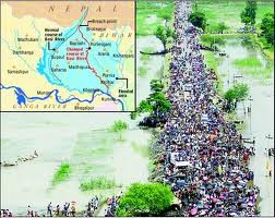
Then and Now. 2008 Kosi Floods, in perspective if the 1948 Floods. Photo: Times of India
Prabhunath Singhsuggested that, “…all the embankments running along the Ghaghara from Darauli in the west to Kasmar in the east via Agampur, Tajpur, Naini Bundh, Sonepur Seva Samiti should be raised and strengthened. Along with this sluice gates should be installed on all the small rivers like Tel and others coming from Naini and Brahmapur to facilitate drainage of the stagnating water.”
He charged the Railway Company of obstructing the process for it felt that if all the other embankments are raised and strengthened, the railway embankments will be adversely impacted. That is the reason this district has to face floods year after year. He suggested to the Government that if it really wanted to help the people in their moment of crisis, it should help the flood victims in rebuilding their houses and arrange seeds for them to put agriculture back on rails. If the Government decides to advance loans for the purpose, it will require nearly Rs 30 million for Saran district alone. With that money it would be better for the Government to device means to make Saran a flood free district for all times to come. He further suggested that the Government must realize the money from the people that it gives to them as help and take advice about the costs involved from the engineers[2]. Saran was a rural district with high population density which was unmatched elsewhere. The villages there were beautiful with rich cultural background. The people there have a high degree of self respect. Gratutious relief should be given only to them who really need it. There are people in our villages who would prefer to die than to queue up for relief.
Timeless flood suffering in Kosi. 2008. Photo: Reuters
Girish Tiwari, also from Saran, said, “…Yesterday someone was asking what is the amount of money orders received in Saran from different places? I want to tell him that the people in Saran will have to starve if their loved ones didn’t send money orders here. The people need relief but there are various ways of providing relief. The places where there is a need of employment, open work there.”
He continued, “There is a stretch of Diyara land starting from Darauli till Sonepur. Let me tell you about Sitab Diyara, the village of Jay Prakash Narayan, which is now located west of the Ghaghara in Balia district of Uttar Pradesh. Many people from this village have shifted to Balia in Uttar Pradesh and some have moved to Rivelganj. People from Nagar Diyara have no place to go and they need land from the Government to settle down somewhere and the Government should acquire land for them. That will be a help.”
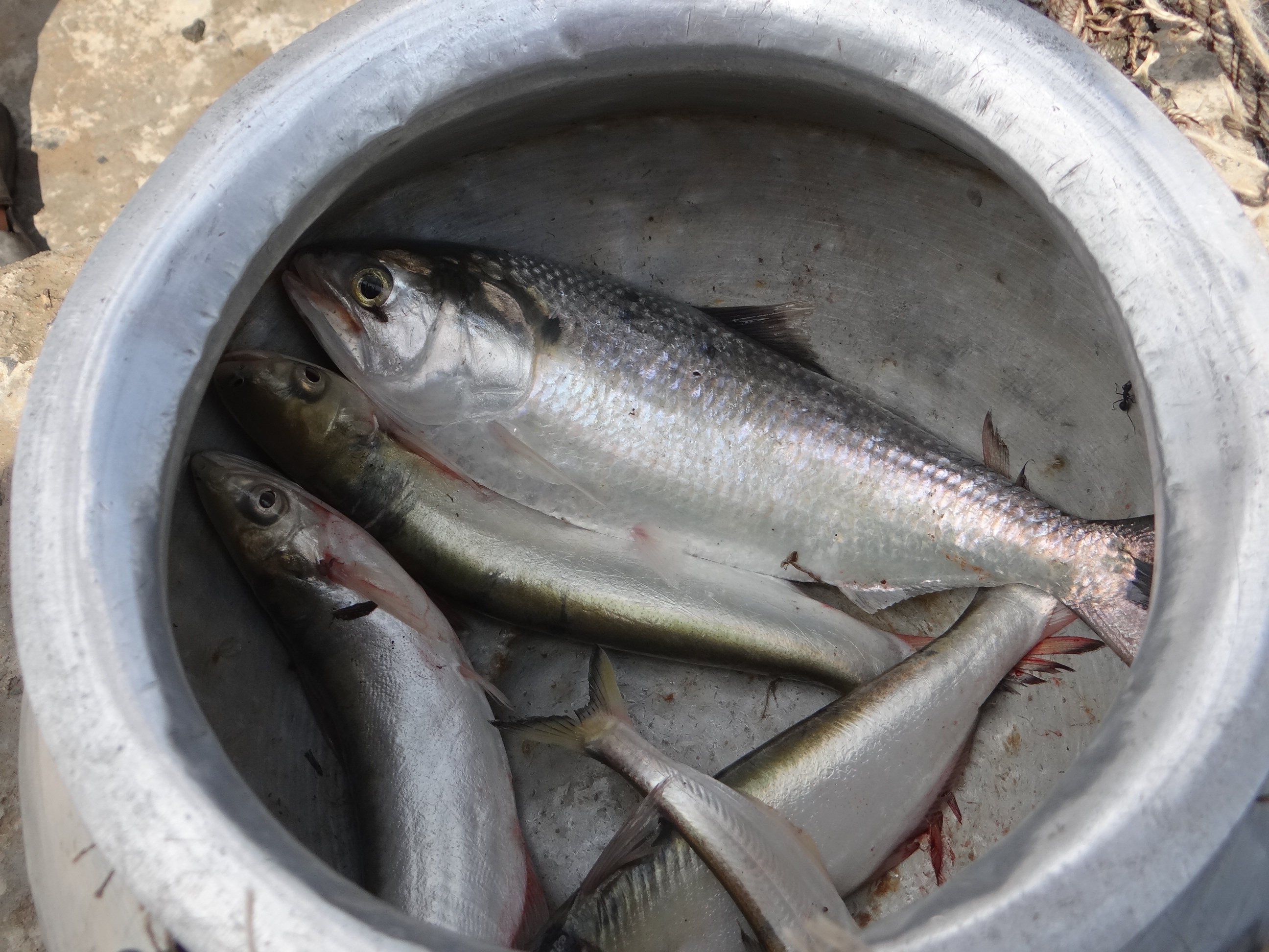
Ram Bonod Singh from Chhapra claimed that, “Not an inch of dry land is available from Manjhi to Sonepur. The current of water was so strong that all the mud houses collapsed. Cattle were in deep trouble. Most of them died or swept away and those survived fell sick. There was no fodder as all the land was under water. Fodder needs to be arranged for them and the Government must open cheap husk and straw shops to save the cattle.
Not much has changed..cattle battling the Bihar Floods now. Photo: BBC News
Dip Narayan Singhlamented that boats were not available normally when the floods struck and the officers had no clue how to face the emergency. Many boats of the traders were parked at Mahnar and Hajipur and had the officers known about their availability they could have helped in rescuing a good number of people from the flooded areas and thus saved their lives. Insisting on the opening of cheap grain shops in the flood ravaged areas he told that a huge amount of food grain was buried under the debris of the collapsed houses and the seeds for the next crop also got trapped there. Such people needed to be helped by ready to eat food and also with seedlings of paddy for immediate transplantation from the areas that were not flooded this year. This should be done without any further loss of time. Some people might need loans for house building and that should be made available to them on deferred payment. Cooperatives could also advance loans to such people wherever they existed. Crop loan might be needed for some and that should be arranged for those who asked for it.
Murli Manohar Prasad talked about floods as a long term problem and said that some years ago there was a meeting with the Government of Uttar Pradesh when it was decided that the Railway Bridge at Majhi on the Ghaghara will have to be extended and embankments should be built on the river from Dhanawari till Chinwari like that built on the Gandak. Uttar Pradesh had opposed this embankment on the ground that the proposed embankment will have adverse impact on the Balia district. He wanted to know from the minister about the fate of those discussions. He also wanted that the issue of deforestation should also be discussed with Uttar Pradesh as massive felling of trees had aggravated the flood situation in Bihar while maintaining that not much benefit is expected from the restoration of forests as, “Unfortunately, the topography of Saran is quite unique. The level of the Gandak river is above the level of its surrounding, the river flows in many streams that take off at various points from the main stream. The level of these streams is also higher than the adjoining land and embankments are built on them also (He was referring to Zamindari embankments.). The local people had developed a very efficient system of irrigation and drainage that worked well till the Moghul Rule. Sluice gates were built on the embankments at various places on the Gandak which helped in controlling various smaller rivers taking off from the Gandak. Whenever people apprehended floods, they used to drop the shutters of the sluice gates. Besides, they have connected the chaurs (depressed lands) with these rivers and could take water from the rivers or discharge water into it with the help of sluice gates. Their drainage channels used to run parallel to the embankment of the river and were connected to the chaurs and the people could manipulate the direction of flow water as they desired. Almost whole of the Saran district was somehow connected to many of its major rivers namely the Ghaghara, the Gandak and the Ganga. Unfortunately, this amazing set up of irrigation and drainage got ruined with time and the sluice gates that were functional till 1878 ceased to function because the indigo planters who were paying the water rates based on the expenses incurred on running the set up to the Government refused to pay it anymore which they were paying so far. That led to the death of a good irrigation and drainage system. When water ceased to flow through these channels then not only the zamindars but rayyats also started encroaching the river bed and the local officers of the Government helplessly watched the proceedings of dismantling law and order situation of the district. His appeal to the Government was that, “it should not end up only distributing relief to the flood victims but should think seriously over the flood problem of the district.”
2013 Kosi Floods Photo: India Today
Prabhunath Singhintervened once again to say that, “The land between Darauli to Sonepur is quite fertile. The district of Saran is rated as a deficit district not because its land is inferior but because its population is very large and per capita availability of land is too small. I want to reiterate, therefore, that the damage inflicted by floods on the district is the only reason of the misery here and the Survey and Settlement Reports confirm it.” The embankment built in Kasmar Pargana from Sonepur to Darauli was earlier looked after by the Zamindars but their attitude changed and they had virtually abandoned the maintenance of those structures which were in ruinous state. He wanted the Government to take over the up-keep and maintenance of these structures. He added that an embankment existed earlier on the left bank of the Ghaghara from Sonepur to Kasmar and all that was needed to be done was repairing this structure. If the Government of Uttar Pradesh objected to it then Bihar Government could always tell them that the embankment already existed and the State was only repairing it. The Survey and Settlement Report records stand a testimony to that effect.
Most of the members of the Assembly were of the view that the policy hitherto adopted of ‘no embankments’ along the rivers should be revisited, should now be changed and embankments must be built wherever needed or demanded by the people. The Government, however, was still not decided and used to pass the buck on the experts’ advice as it very well knew the consequences of embanking of heavily silt laden rivers.
Two ministers in the Government replied to this entire debate in the Assembly and their statements are worth studying minutely. First to reply was Ram Charitra Singh who said, “… It is quite likely that the reason for the floods in North Bihar are the people themselves living in the State. Almost all the rivers of North Bihar have their origin in the Himalayas that are covered with ice. All the rivers that discharge their water into the sea bring a lot of sediments in their flow and deposited it on their path to the sea. That is how the land was formed in this region. Then came the human race which started tampering with the rivers for its own benefits and its lack of foresight resulted in the situation that we are faced with now. The debate that has taken place in the House establishes that we are still trapped in the same mindset. The result is that many embankments have been built and many others are in the process of being built. The debate today in this House has revealed that many of our friends desire that we should continue building the embankments and they believe firmly that this will benefit them and improve the flood situation. I must say that, scientifically, had these embankments not existed the problem of this magnitude were not going to be there but what has happened has happened. We now better concentrate on the future course of action. Our policy is to control the construction of embankments. Wherever these embankments are built, their construction is illegitimate and a vigil has got to be kept on them. At some places there were constraint and embankment had to be built there although it creates problems.”
He continued, “…I went to the Saran district recently and stayed there for three days (watching the flood situation) and immediately after my return here I got 14 embankments built along the Ganga for flood protection including Dighwara, Shitalpur and Kaudimal. I am not upset that so many embankments have been destroyed this year and a sum of Rs. Two lakhs twenty thousand has been wasted but I don’t regret it and should our engineers suggest that an embankment is essential, I will not hesitate helping them build it.” He admitted that the kind of damages due to floods that were seen in Saran this year were not seen elsewhere and assured all his help to the district. Emphasizing the need for drainage of the Chhapra town he had already instructed the Chief Engineer, Special Officer and the District Magistrate to repair the roads, railway line in collaboration with the District Board even if it amounted to cutting the railway line immediately. The Kharif crop was already lost and if the water is not drained out, the chances of Rabi would also recede.
Another minister, KB Sahay had this to say. “…The problem of floods is very critical. If we construct embankments in Saran, what impact will it have on the other districts? If we control the Ganga in Saran, how will that effect the other districts in UP? I want to put all these facts before the House and want to assure you that the Government will appoint a Commission whose job will be to tell that if an embankment is to be built in Muzaffarpur, it should tell us where and how?…If in Patna then where and how and so on.”
[1] This is Third part of a series of articles Dr Dinesh Kumar Mishra has written for SANDRP based on his month long research at the National Library, Kolkata recently.
For Part 1 see: https://sandrp.wordpress.com/2015/03/09/1948-floods-in-bihar-1-inaugural-flood-after-independence-view-from-press-gallery/
Part 2: https://sandrp.wordpress.com/2015/03/10/1948-floods-in-bihar-2-inaugural-flood-after-independence-official-version-of-floods-and-its-aftermath/
[2] He meant that the Government should not give money to the flood victims just as a dole. It was to be a soft loan and the estimates etc should be suggested by engineers.
Government of Bihar, Revenue Department, Report on the Flood and Relief Operations in Bihar for 1948-49. Superintendent, Government Printing, Bihar, Patna, 1951.
Muzaffarpur [2]“During the August floods water from the River Narayani flooded the village Fatehabad. About 100 houses are reported to have collapsed as a result of the breach in the bundh due to change in course of the River Gandak. There were heavy showers and considerable damage was caused to the paddy crops and certain parts of the Sadar and major parts of Katra, Minapur and Sakra thanas experienced floods… During floods in the Ganges, Hajipur sub-division was badly affected and steps had to be taken to arrange relief.” P-15 Continue reading “1948 Floods in Bihar-2 Inaugural flood after Independence – Official Version of Floods and its Aftermath”→
Background Bihar is long known for its floods. The British had left India but their legacy of looking at rivers and their floods was still continuing in 1948[1]. They always favored ‘leaving the rivers to their own devices’ and did precious little to tame the rivers. The zamindars used to put temporary and not so temporary embankments along the rivers to provide some flood protection to their ‘ryots’ which used to breach quite often to the detriment of the people living in the flood plains of the river. The repairs of such breaches were the responsibility of the zamindars but if they did not repair the same, the British establishment used to repair it and realize the cost of it from the zamindars. There were only 160 kilometers of ‘well designed and equally well constructed’ embankments on Bihar Rivers then. Zamindars had got a hint from the Government of India that their days were numbered and had little interest in maintaining the embankments in order. It was under these circumstances that the Government of Bihar (GoB) was expected to face the floods for the first time in independent India.Continue reading “1948 Floods in Bihar-1 – Inaugural flood after Independence – View from Press Gallery”→
“When Farakka barrage was built, the engineers did not plan for such massive silt. But it has become one of the biggest problems of the barrage now” said Dr. P.K. Parua[1]. And he should know as he has been associated with the barrage for nearly 38 years and retired as the General Manager of Farakka Barrage Project (FBP). I remembered the vast island of silt in the middle of the river barely a kilometer upstream of the Barrage and the people who told us their homes were devastated by the swinging river.
Silt Islands just upstream the Barrage. Photo: Parineeta Dandekar, SANDRP
Though called a barrage, Farakka Barrage is a large dam as per ICOLD, WCD and CWC definitions, with associated large dimensions and impacts. To call it a Barrage is misleading.
Commissioned in 1975[i] across Ganga in Murshidabad District of West Bengal and just 16 kms upstream of the Bangladesh Border, Farakka Barrage has been mired in controversies from the very beginning. Its role is singular: to transfer 40,000 cusecs water from Ganga to its distributary Bhagirathi-Hooghly (hence forth referred as Hooghly). And to make Hoogly river navigable from Kolkata port upstream till Farakka barrage. It was thought that this water will push the silt that is eating up the Kolkata Port and will protect the Port for navigation and economy. In reality, Kolkata Port continues to decay and the barrage has had such severe and unforeseen impacts on the people of India and Bangladesh that the call to review Farakka Barrage entirely is getting louder by the day.
A lot has been written about Farakka Barrage by Indian (and many times by Bangladeshi) authors, so why are we discussing Farakka again? Because Political leaders like Shri. Nitin Gadkari have stated that there are plans of building a barrage after every 100 kms in Ganga from Haldia to Allahabad, a 1600 kms stretch. So we are looking at possibly 15 more barrages on Ganga. But before taking decision about building any other such structure, we need to understand the range of impacts a single barrage has had on the lives of millions of people and how inadequate has been our response in addressing these impacts. Farakka holds critical lessons for Indian politicians, policy-makers, international groups and financial institutions like World Bank dreaming of making a string of barrages across a river which has one of the highest silt loads, densest population and the largest deltas in the world.
Ganga as a “Waterway” Government of India is planning to aggressively develop 1620 kilometers of National River Ganga as “National Waterway 1” (NW1). There is a profound difference between a Highway and Waterway. A highway is simply a road while NW1 is actually River Ganga, performing several other functions, it is important to recognise how the NW1 would affect these functions and the river itself. NW 1 spans from Haldia, near the mouth of Ganga Estuary in West Bengal, to Allahabad in Uttar Pradesh, passing through four states and cities of Haldia, Howrah, Kolkata, Bhagalpur, Buxar, Patna, Ghazipur, Varanasi and Allahabad.
The Inland Waterways Authority of India (IWAI)[ii] plans to use this waterway for the transport of “coal, fly-ash, food grains, cement, stone chips, oil and over dimensional cargo.” Not surprisingly, companies keenly interested in using this waterway include “thermal power plants, cement companies, fertilizer companies, oil companies” etc. In order to make this stretch navigable, IWAI plans initiatives like “river training and conservancy, structural improvement, dredging, and Construction of terminals at Allahabad, Varansai, Gazipur in Uttar Pradesh, Sahibganj in Bihar and Katwa in West Bengal.”
Although this plan was on paper for some years, the new government has approached the World Bank for support of nearly Rs 4200 Crores (700 million dollar) for its implementation. In July 2014, the World Bank agreed to fund initial 50 million dollars including technical support (thus creating work for its own experts!). World Bank Team has already visited Patna for this project and joint meeting of IWAI and World Bank has taken place at Varanasi[iii]. No public consultation has been held thus far.
Although River Navigation has nothing to do with River Rejuvenation, Shri. Nitin Gadkari, Union Surface Transport & Shipping Minister with additional portfolio of Rural Development, who played an active role in the Ganga Manthan, announced this navigation plan as a part of ‘Ganga Rejuvenation’.[iv]
He also announced that the plan entails erecting barrages (dams) on the Ganga at every 100 kilometer interval from Haldia to Allahabad. This would mean damming the Ganga rough about 15-16 times, to maintain water levels and navigability.[v]
If the plan moves ahead, it may escape environmental clearance as the very limited EIA Notification 2006, being actively amended for dilution by the Modi government, includes only irrigation and hydropower dams in its ambit. This does not mean that these barrages will not have severe impacts on the river, its people and its ecosystems. Far from it. SANDRP has written about the impacts of Upper Ganga Barrage at Bhimgouda, the Lower Ganga Barrage at Narora and the Farakka Barrage in Murshidabad, West Bengal (SANDRP’s Report on Farakka, 1999: https://sandrp.in/dams/impct_frka_wcd.pdf).
The analysis at hand is based on official documents and research, site visit, interviews and discussions with experts and local people.
Farakka Barrage, in the backdrop of proposed Barrages
Farakka Barrage, 2.62 kms long, commissioned in 1975 has a unique purpose. The barrage was built for diverting waters of Ganga into its distributary The Hooghly/ Bhagirtahi, for flushing sediments and maintaining the navigability of Kolkata Port (& Hooghly River) which lies at the mouth of Hooghly. Records about high sedimentation in Hooghly can be traced back to 17th Century, but is known to increase following building of Damodar Dams in post independent India. Construction of a barrage on Ganga and diverting its waters into Hooghly was suggested in the 19th Century by Sir Arthur Cotton. After independence, the historic Kolkata port was becoming hugely silted due to sluggish freshwater from upstream on the one hand and and strong saline intrusion from the sea on the other. At that time, Farakka Barrage was thought to be an answer to these problems.
The Farakka Barrage. Photo: Author
Even then, some lone voices highlighted the possible impacts of Farakka Barrage. Notably Mr. Kapil Bhattacharya, Engineer-in-Chief of West Bengal had warned about absence of sufficient water, catastrophic floods and sedimentation in the upstream back in 70s. When Pakistan (current Bangladesh was part of Pakistan during 1947-1971) upheld his views, he was branded as a traitor and lost his job. He had highlighted that one of the main reasons why Hooghly was desiccating was Damodar Valley Corporation (DVC) dams on Damodar and Roopnarayan Rivers.
The Farakka Barrage completed in 1975 has 109 gates, and a feeder canal of 38.1 kms emanating from the right bank, carrying water from Ganga to Hooghly. There is one more barrage at Jangipur in the downstream and afflux bunds in the upstream of Farakka, diverting waters of all smaller rivers like Pagla and Choto Bhagirathi into Farakka, effectively drying them in the downstream.
The Feeder canal is supposed to divert 40,000 cusecs water continuously from Ganga into Bhagirathi/ Hooghly. Hooghly-Bhagirathi itself is not a small river. It is a system drained by 7 tributaries like Pagla, Bansloi, Mayurakshi, Ajoy, Damodar, Rupnarayan, Haldi and the two offshoots of Ganga – Jalangi and Churni.
Location of Farakka Barrage Depiction From : Rudra, Encroaching Ganga and Social Conflicts
Impacts and performance of Farakka Barrage
Several grave questions are being posed on the utility of the barrage itself and its impacts. Some of the main points are illustrated below:
Hooghly estuary cannot be made silt-free by 40,000 cusecs from Farakka only
River Expert Dr. Kalyan Rudra, an authority on rivers in Bengal, especially their interactions with sediment, says that the initial objective of Farakka of flushing silt from the mouth of Hooghly has been “frustrated”[vi]. This assessment has been supported by many, including the past Superintending Engineer of Farakka Dr. P.K. Parua (Pers. Comm.) According to Kolkata Port Trust, the dredging of silt at Kolkata Port has been rising from 6.40 million cubic meters (MCM) annually from Pre-Farakka days to four time increase at 21.88 MCM annually during 1999-2003.
The answer, according to Dr. Rudra, lies in the fact that freshwater flow brought by the Hooghly Estuary, even with 40,000 cusecs from Farakka is just too meagre to flush sediments deep down the estuary. The difference between volumes of freshwater brought by Hooghly, as against the tide bringing saline water from south to north is as much as 1:78, making any deep flushing due to freshwater nearly impossible. Dams in the Hooghly Bhagirathi Basin by Damodar Valley Corporation have further arrested freshwater which could have naturally replenished Hooghly estuary. At the same time the stated aims of Damodar Valley Corporation, fashioned on the lines of Tennessee Valley Authority have not been fulfilled.
Currently, the functioning of Kolkata Port and Haldia port is entirely at the mercy of Dredging Corporation of India (DCI) to desilt the river to maintain sufficient draft (allowable depth of a ship’s keel under water). DCI gets about Rs 300-350 Crores per year for dredging the channel, although several problems have been unearthed like dumping the excavated silt back in the estuary from where it is washed back in the channel. In 2009, the Government of India had actually written to the Kolkata Port Trust, saying that it has become a “liability” and it should explain why it should continue to receive dredging subsidies. A PIL has been filed[vii] in 2013 in Kolkata High Court to save Kolkata and Haldia ports by intensive dredging.
Dredging the National Waterway I Photo: WRIS
It is clear that 40,000 cusecs water from Farakka is not able to help the Kolkata Port much as was envisaged earlier. SANDRP tried to talk with officials at the Kolkata Port Trust, but they declined answering any questions saying that Farakka is a bilateral issue.
This has led to a situation where we have the barrage and the impacts of two countries and millions of people, without even achieving objective for which the project was developed.
2. Sedimentation in the upstream of Farakka Barrage and its massive implications for India and Bangladesh
It is estimated that Ganga carries a silt load of 736 Million Tonnes (MT) annually, out of which about 328 MT of sediment gets deposited in the upstream of Farakka Barrage ANNUALLY[viii]. This annual addition of enormous sediment in the upstream of the barrage has made the river extremely shallow and any ship transport past Farakka has become nearly impossible. As we saw during our visit, islands/chars have formed barely a kilometer upstream the barrage, where animals graze, making any transport nearly impossible.
This massive retention of sediments has resulted in a two-pronged problem:
3. Contribution to delta subsidence and rising sea level in Bangladesh and India
Water released below Farakka barrage has significantly less silt load as about 328 MT silt gets deposited at Farakka. This water has a higher eroding capacity and erodes downstream riverbed. But there is an additional problem: World Heritage site of Sunderbans at the mouth of the Ganga-Brahmaputra-Meghna delta, shared between India and Bangladesh is witnessing possibly the first and highest numbers of Climate Change refugees in the world due to Ingressing Sea which is eating away at smaller islands and the delta. Part reason for this delta subsidence is sea level rise due to global warming and related changes, but the driving reason for encroaching seas is not only sea level rise, but the sinking river delta due to trapping sediment in the upstream dams and barrages like Farakka. The role of river sediments in building deltas is crucial. Ganga-Brahmaputra-Meghana Delta is subsiding rapidly and is categorized as a ‘Delta in Peril’ by experts like Syvitski et al, due to reduction in sediments reaching the delta and compaction of delta, furthering sea level rise. According to recent studies, the rate of relative sea level rise per year in the Ganga Brahmaputra delta is in the range of 8-18 mm per year, one the highest in the world. The related sediment reduction has been a whopping 30% in the twentieth century. (SANDRPs report on Delta Subsidence and Effective Sea Level Rise due to sediment trapping by dams: https://sandrp.wordpress.com/2014/05/07/sinking-and-shrinking-deltas-major-role-of-dams-in-abetting-delta-subsidence-and-effective-sea-level-rise/)
Farakka Barrage has been highlighted as one of the causes for this blocking of sediments at an important juncture. Any role played by Farakka in delta subsidence of GBM Delta has a massive impact on millions of people residing in this delta. According to Prof. Md. Khallequzamman (Pers Comm.), the amount of sediment influx flowing into Bangladesh from upper reaches in India has dropped from 2 billion tons per year in the 1960s to less than 1 billion tons per year in recent years, which is not enough to keep pace with rising sea.[ix]
4. Erosion in the Upstream of the barrage due to Sedimentation
Farakka Barrage is getting silted up due to millions of tonnes of sediment being deposited in the upstream annually. Ganga has been a meandering river, changing courses over centuries, forming paleo channel and ox bows. This deposition of sediment in the upstream is accelerating swinging of Ganga alarmingly to the left bank of the river. This is leading to tremendous erosion in Malda and surrounding regions. More than 4000 hectares of land in Malda has been eroded by the Ganga since 1970s. The river has also breached 8 embankments. Although a number of authors have conclusively written about this and even Legislative Assembly of West Bengal has been unequivocal in saying that “It is accepted all levels that the construction of Farakka Barrage is solely responsible behind the erosion of river Ganges in Malda district”, Central Water Commission trivializes this fact and does not accept any responsibility of Farakka.The only issue CWC seems to be bothered about is the health of the barrage itself which is compromised by erosion on the left bank. In official correspondences of CWC and MoWR scrutinized by SANDRP, the agencies do not mention anything about plight of thousands of people, who are refugees of a swinging river, but are only concerned about the strength of the barrage.[x]
According to Audit Report on Farakka Barrage by Indian Audit and Accounts Departments, between 2006-2012, the “Unintended Consequences” of Farakka include:
Induced water through feeder canal raised water level of Bhagirathi by about 5 meters near Jangipur and does not allow Bansloi and Pagla to join Bhagirtahi freely. A new wetland due to congestion formed Ahiron Beel which has submerged fertile land.
The barrage has trapped substantial sediment and hence river in changing course. In homogenous situation the oscillation of river is secular but it gets aggravated due to Farakka Barrage. On account of Rajmahal hills on right bank and Farakka barrage on the channel, the river erodes the left bank.
The 10 day cycle of increased and decreased release of water from the Barrage has resulted in a complex phenomenon of recharging ground water by river and then receiving base flow from groundwater ( when river is low). The frequent change in water level on account of 10 day altered flow adversely affects the rivers hydro geomorphology leading to escalating bank erosion.
River bed height in Farakka pondage has increased and the river is compensating this reduction by expanding its cross section sideways
Bank Erosion and Embakment breach at Hiranandpur Phot with thanks: Soumya Desarkar
5. Erosion Downstream of the barrage, leading to loss of life and property:
Sedimentation upstream the barrage, coupled with natural swing of Ganga has meant that the river is swinging to the left, encroaching the left bank, leading to erosion in thousands of villages, roads, fields in the downstream of the Barrage in India as well as Bangladesh, causing annual floods. The Irrigation Department West Bengal (Report of the Irrigation Dept for 1997-2001) itself has agreed not only about this erosion due to Farakka Barrage, but has also cautioned about the possibility of outflanking of the Farakka Barrage itself. Many experts maintain the eminent possibility of Ganga outflanking the barrage to flow through its old course of the 15th century, which will reduce the barrage to just a bridge.
On our visit to Farakka, Kedarnath Mandal, a veteran activist working on issued of Ganga and Farakka accompanied us to see extensive erosion in the left bank of the river in the upstream at Simultola as well as downstream in ChaukBahadurpur. In both these regions, the eroding river has paid little heed to the erosion control measures on the banks. Huge boulders have been swept with the current, destabilizing land in their wake.
Washing away erosion control measures at Chow Bahadurpur downstream FBP Photo: Author
We saw extensive bank erosion in the left bank on the downstream where all measures like bull headed spurs, dip trees, porcupines, gunny bags, geo-synthetic covers, boulders bars, boulder crates with nets, etc. have been eroded.
In all this din, the people residing in the chars, their leaders like Kedarnath Mandal, River experts and even the Legislative Council of West Bengal maintain that though erosion and changing courses is a character of Ganga, it has worsened and accelerated hugely since Farakka Barrage. In fact the 13th Legislative Assembly Committee (2004) in its 7th Report notes “It is accepted at all levels that the construction of Farakka Barrage is solely responsible behind the erosion of river Ganges in Malda district”.
6. Near Impossibility of desilting Farakka Barrage
To say that the challenge of desilting Farakka Barrage is Herculean, will be an understatement. The irreversible circle of events is highlighted by the fact that in order to have any appreciable impact, the amount of sediment lifted from the barrage should be at least twice the amount deposited per year, if the project is to be completed even in thirty years. But that seems impossible. According to Dr. Rudra, “Doing so will require a fourteen lane dedicated highway from Malda to Gangasagar” and the transport cost alone “would be nearly twice the revenue earned by Government of India in a year.” Dr. P.K. Parua also accepts that desilting the barrage will be next to impossible.
Such is the scale of sedimentation at Farakka.
7. Source of conflict with Bangladesh
Experts and authorities from Bangladesh have been raising the issue of impact of Farakka for several years now. Farakka Barrage not only obstructs the flow of sediments in Bangladesh, but also diverts waters of Ganga away from Bangladesh delta, depriving millions of fisherfolk and farmers from their livelihood. Water sharing from Farakka, particularly in lean season is now governed by Ganges Water Treaty of 1996. The Treaty holds force between 1 January to 31st May each year and water sharing calculations are based on 10 day flows. Some experts from Bangladesh have maintained that Ganges Water Treaty is not being implemented properly and Bangladesh is receiving less water than its due.[xi] There are issues raised by the Indian side as well of dwindling water availability. All in all, the barrage and the resultant Treaty continues to be a source of impacts for the river and people of the two nations.
Meeting officials at Farakka Barrage
SANDRP met with the Authorities at the Farakka Barrage Project office, which is under the Ministry of Water Resources (MoWR), at New Farakka. After meeting the officials, it was clear that they have no program for silt management at all. They do not even see this as an area of concern and are only concerned with anti-erosion works, which are failing miserably, and releasing water to Kolkata Port, which is not improving its navigability.
While some may argue, rather irrelevantly (considering the warnings of Kapil Bhattacharyya), that Engineers in 1950s, 60s and 70s were not equipped or aware of the issues related to sediment and its far-reaching impacts like erosion, deposition, floods, even sea level rise, the same in any case cannot be said about the current water management. They have the privilege of better knowledge, better resources and also lessons from past experiences. But despite having clear evidence that silt of Ganga is playing havoc with millions in India as well as Bangladesh, the Farakka Barrage Authorities tell us that they have no plan for silt management the barrage except annual erosion control measures.
The mandate of the barrage authorities is also 120 kms of bank erosion works, 40kms in the upstream and 80kms in the downstream. We were told on the condition of anonymity that this extensive work leaves little time even for maintaining the barrage. The bank protection work is also not permanent and is eroded with flood waves. The bureaucratic set up at Farakka makes it impossible to take proactive decisions about Barrage maintenance. The gates of the barrage need replacement, but there is hardly any agency interested in working for Farakka Barrage due to bureaucratic delays.
The officials told SANDRP that the only desilting measure that can be adopted is opening all gates of the Barrage, but that will not be possible unless all gates are replaced as many gates are faulty. Replacing all gates of Farakka will take at least two more years and we do not know even after that whether silt can be flushed. Such a flushing will need a major flood event and the impact of such sudden flushing of billions of tonnes of silt in the downstream will be unprecedented & huge.
Meeting with Farakka Barrage Authorities leaves one with more questions than answers.
Interview with past official of Farakka
SANDRP discussed the multiple issues of Farakka with one of the senior retired official from the Farakka Barrage Authority who has seen the work of the FBPA closely over several years. Some excerpts from these discussions.
SANDRP: Sir, do you think Farakka is fulfilling its functions?
Answer: Farakka was not only designed for diverting water for Hooghly, it was foreseen that there may be an Irrigation component and even a hydropower component. But the inflow at the barrage was over calculated. We never had that sort of inflow in the project. Add to this Treaty with Bangladesh in 1996 and India was left with little water. I would say objectives of Farakka were only partially fulfilled. The barrage has a designed discharge of 27,00,000 cusecs and we have been able to achieve that discharge only twice since commissioning the barrage. In the recent years, water flow has been declining sharply at the barrage. This further handicaps all its functions.
SANDRP: There are several problems associated with silt deposited in the upstream of the barrage like floods, change in course of the river, erosion, etc. Is there any way to tackle this deposited silt?
Answer: Yes, that is a serious problem. This is being faced by ports and barrages the world over and also across India. There are so many players responsible for the increasing silt load and reduced water in the river, right from Nepal.
We can say that the scale of the sediment issue was not understood when the barrage was designed, the engineers then did not have the knowledge or tools for this. Even now, there is no easy way this issue can be tackled. Desilting the barrage would be very costly, and what would be do with the collected silt? Malda and Murshidabad region is densely populated, we cannot dump it anywhere. If we dump it in the river, there will be other problems. It is possibly an evil we have to live with now.
SANDRP: There are plans to erect about 16 more such barrages on the Ganga main stem. What would be the lessons from Farakka for these barrages?
Answer:I think this is a horrible plan. In addition to the challenge of silt, I wonder where will the water come from? Supplies from Upper Ganga Canals are increasing, reducing water flow in the river. Uttar Pradesh is increasing the capacity of Lower Ganga Canals. More and more abstraction will happen. Such a plan does not seem feasible and will be harmful for the river as well.
Ecological Impacts
There’s no Hilsa here
Farakka Barrage has stopped migration of economically important species like the Hilsa (Tenualosa ilsha) and Macrobrachium prawns, both Ilish (Hilsa) and Chingri (Macrobrachium) hold a special significance to people in West Bengal and Bangladesh. A lot has been written about the Barrage’s disastrous impact on Hilsa production and impoverishment of fisherfolk in India and Bangladesh[xii]. About 2 lakh fisherfolk in Malda district alone depend on riverine fisheries and Hilsa here was the backbone of the fishing economy.
Although Central Inland Fisheries Research Institute (CIFRI) has a lab to work on Hilsa, the institute is not working on Fish passes or Hilsa Hatcheries at the Barrage itself!
Fishermen upstream Farakka are a worried lot Photo: Author
Prior to commissioning Farakka Barrage in 1975, there are records of the Hilsa migrating from Bay of Bengal right upto Agra, Kanpur and even Delhi covering a distance of more than 1600 kms. Maximum abundance was observed at Buxar (Bihar), at a distance of about 650 kms from river mouth. Post Farraka, Hilsa is unheard of in Yamuna in Delhi and its yield has dropped to zero in Allahabad, from 91 kg/km in 1960s. Studies as old as those conducted in mid-seventies single out Farakka’s disastrous impacts on Hilsa, illustrating a near 100% decline of Hilsa above the barrage post construction.[xiii]
We met fishermen who have not caught a single Hilsa in the upstream of the barrage despite fishing for three days. In the downstream too, size and recruitment (population) of Hilsa is affected due to arrested migration at Farakka. Some 2 million fisherfolk in Bangladesh depend on Hilsa fishing. Hilsa in Padma river (Ganga in India) downstream Farakka has also declined sharply due to decreasing water and blockage of migration routes.[xiv]
Lone Hilsa caught by a fishermen after three days of effort, sold for a pittance to local fish dealer. Photo: Author
These fisherfolk have never been compensated for the losses they suffered. They were not even counted as affected people when the barrage was designed and they are not counted even now.
Fable of Farakka Fish Lock
The tale of Farakka Barrage Fish Lock is another tragic story. Fish Lock is a gated structure in a Barrage that needs to be operated specifically to facilitate migration of fish from the downstream to the upstream or vice versa to breed, feed or complete their lifecycles.
According to Central Inland Fisheries Research Institute (CIFRI), Farakka Barrage has two Fish Locks between gates 24 and 25. The locks need to be operated to aid fish migration and transport fish. We talked with the Engineers at Farakka Barrage Authority, local villagers, fishermen and even the Barrage Control Room officials who operate the gates of the barrage about the functioning of the Fish Lock. No one had heard about a Fish Lock. There is some information that there is one more lock further upstream in the river, but the FBP Authorities did not seem aware of this.
The control room officials kept showing us the ship lock at the Barrage (which is also rarely used due to turbulence and sedimentation) and told us categorically that “There is nothing called as fish lock here”. The locks have not been operated for a minimum of a decade, possibly much longer.
Who is responsible for the loss of fisherfolk income in the meantime? Will the Farakka Barrage Authority or the MoWR or the CWC or the Kolkata Port Trust or Inland Waterways Authority of India compensate them?
Fisherman upstream Farakka Barrage. He says Hilsa is nearly wiped out from here and there is intense conflict for a meager catch. Photo: Author
According to Dr. Parua, fish locks were operated for some time when he was posted at Farakka, but they never worked as planned. He believes that a bare 60 feet fish lock for a barrage that is more than 2.6 kms long is of little use. There should have been more fish locks planned. He also lamented about the non-functionality of Hilsa Fish Hatchery set up at the banks of the barrage. (We were not even told about the presence of this structure by any of the officials or other concerned persons we met and possibly it has now fallen to complete disrepair now.) He said despite Central Inland Fisheries Research Institute (CIFRI) is based in West Bengal and has a special cell to study Hilsa, they or the Fisheries Department have taken no interest in the functioning of the hatchery or the Fish Locks.
2. Vikramshila Dolhin Sanctuary, Bhagalpur
Bhagalpur is barely 150 kms upriver from Farakka and Dr. Sunil Chaudhary, a past Member of the Sate Wildlife Board of Bihar has been working relentlessly on conservation of Gangetic Dolphins, as well as rights of traditional fisherfolk in Bihar and around Vikramshila region.[xv] SANDRP discussed the issue of Farakka and additional barrages with him. Dr. Chaudhary states that not only barrages, but the dredging itself will have serious impacts on Dolphins. Impacts of Farakka Barrage on fish and fisherfolk in Bihar is still being felt. No Hilsa reach here from Farakka and a generation of fisherfolk has suffered due to this. Forget more barrages on the Ganga, we need a review of Farakka Barrage itself as Ganga Mukti Andolan has been asking for years now.
Any work affecting Vikramshila Dolphin Sanctuary will require clearance from State Wildlife Board, State Wildlife Warden and National Board for Wildlife. We hope that such permissions are not given without due diligence and independent application of mind and at least whatever remains of Ganga is maintained.
In conclusion
The issues arising out of Farakka are extremely serious. Our planners and decision makers may claim that many of the impacts were not foreseen (Not entirely true). But the issue cannot be ignored any longer. We need a credible independent review of the development effectiveness of Farakka Barrage, including costs, benefits and impacts.
What we seem to be doing now is to repeat the mistakes of the past with new barrages planned on the Ganga.
The existing Upper Ganga Barrage (Bhimgouda Barrage) has dried up the river in the downstream. The river is diverted in a canal, where people take ritual baths, while the original riverbed is used as a parking lot.
Dry Ganga downstream Upper Ganga, Bhimgouda Barrage in Haridwar Photo: Author
The Lower Ganga (Narora Barrage) has severely affected fish migration & dried up the river in the downstream at least in lean season. The Barrage has a fish ladder, but there is no monitoring or concern as to whether it is working or not. In its report to the World Bank, Uttar Pradesh Government has said that the “condition of the barrage is poor” and has lamented about increased siltation in the upstream of the barrage and the inability to flush the sediments due to poor condition of its gates.[xvi].
Beyond doubt, the existing barrages, especially the Farakka Barrage have had massive impacts on the river, its ecosystems and its people. We have many critical lessons to learn from these experiences. In stead, we are pushing for more barrages on a river which will only compound existing problems.
Ganga is much more than a waterway or a powerhouse. It is a river, supporting not only urban areas and industries, but rural communities, the basin, the ecosystem and myriad organisms in its wake and it needs to be respected as an ecosystem first, rather than for sentimental reasons like mother or goddess.
The Ganga is being fettered at its origin in the Uttarakhand by over 300 hydropower dams. In addition, if it is again dammed many times over times in its main channel, then the government will not have to worry about River Rejuvenation Plan. There will be no river left for rejuvenation.
A Photo Feature on Farakka Barrage: https://sandrp.wordpress.com/2014/09/29/world-rivers-day-and-ganga-a-look-at-farakka-barrage-and-other-such-calamities/
During Sept 4-6, 2014 Jammu and Kashmir in North India is facing one of the worst floods. NDTV[1] has reported that these are the worst floods in 60 years (The Times of India reported that this was worst flood of the state since independence based on number of casualties.). More than 160 people have died and some 2500 villages are affected (1615 in the valley, rest in Jammu), out of which 450 are completely submerged (390 in valley)[2]. Over 10 000 people are stranded across the state. The flood has affected almost all 10 districts in the Jammu region. J&K Chief Minister admitted that the rescuers have yet to reach the worst affected South Kashmir region. Jammu Srinagar Highway has remained blocked for over three days. Several rivers have been flowing above the danger mark and most parts of south Kashmir, including Pulwama, Anantnag and Kulgam districts have been submerged. Jhelum was flowing at 30.7 ft in South Kashmir, 7 ft above the danger mark. Chenab river was also flowing above the danger mark at several places.
Authorities have declared the bridge over the Chenab in Akhnoor unsafe for traffic. Source: Vinay Saraf’s facebook post
Unprecedented floods Landslides triggered by heavy rainfall have damaged roads, dozens of bridges, buildings and crops. As many as 40 people went missing after a landslide in Thanamandi area of Rajouri district in Jammu region. Heavy rain in the catchment areas of Jhelum river has so far submerged more than 100 villages in the south Kashmir districts of Anantnag, Kulgam, Shopian, Pulwama, where the river was still rising, as well as the north Kashmir districts of Ganderbal, Srinagar and Badgam[3]. The flood has surpassed the 1992 memories and revived the 1959 flood memories[4].
Flood Forecast map of CWC has no sites to forecast floods in J & K
Vehicular traffic has been stopped on the Jammu-Pathankot highway due to incessant rain. Jammu is on red alert and Tawi bridge is also in danger.
Flood image from Vinay Saraf’s Facebook post
State Finance Minister Abdul Rahim Rather said Chenab was flowing at 38 ft at Akhnoor which is four ft above the danger mark cumulatively discharging 2.75 lakh cusecs, a quantum of discharge which equals all other rivers of the state.
The situation is very grim indeed: “According to the Army, the situation in the state is as grim as it was in Uttarakhand last year.” Union Home Minister has visited the state and the prime minister has expressed grief.
VERY HEAVY Rainfall during Sept 3-6 The state received massive 250 mm of rainfall in just three days between Sept 3-4, out of its seasonal monsoon rainfall of 568 mm till Sept 6, 2014. Rainfall just on Sept 6 was 106 mm, which is unbelievable 3116% of the normal rainfall for that date for J&K.
Rainfall Map from IMD showing that J&K received 558 mm rainfall till Sept 6, progressing to excess rainfall category in three days from deficit category on Sept 3, see the next map below
It can be seen from the season rainfall map see above of India Meteorology Department as on Sept 6, 2014 that J&K had received 558 mm rainfall till that date, progressing to Excess Rainfall category (blue colour code) from Deficit season rainfall of 308 mm as on Sept 3, 2014 (see IMD map below), in just three days.
IMD Map of Sept 3, 2014, showing J&K in deficit rainfall category (brown colour) with seasonal rainfall of 308 mm
CWC has no flood forecasts for J&K However, shockingly, India’s premier water resources body, Central Water Commission, responsible for flood forecasting and providing advisory to the states for tackling floods, has no flood forecast for any place in the state. The CWC’s flood forecast list[5] on Sept 6, 2014 has 18 level forecasts and 8 inflow forecasts, but NONE from J&K. CWC’s Flood forecast site has another option[6] that provides hydrographs for various rivers and location. Again for J&K it provides NO hydrographs. The options on CWC’s Flood Forecast site for list based selection[7] and map based selection[8] again has no information about Jammu & Kashmir.
J&K Flood Control Chief Engineer called the situation Alarming. Photo Source – NNIS
This seems like shocking omission on the part of CWC, which functions under Union Ministry of Water Resources and reminds one that CWC completely failed to provide any flood forecast when Uttarakhand faced its worst floods in June 2013[9]. We hope CWC will urgently include the flood vulnerable sites of J&K in its flood forecasting and also explain to the people of J&K and rest of the country why these sites were not included so far.
Akhnoor flood image from Vinay Saraf’s Facebook post
Mismanaged hydro projects increase the damage In this context, media has reported[10] that Dulhasti Hydropower project on Chenab river decided to open its flood gates DURING the worst flood period, which lead to further increase in flood levels in the downstream areas: “Release of water by NHPC dam is expected to increase the levels of the Chenab massively between Kishtwar and Ramban. Surged level can lead to submergence of the highway.” Such additional floods could have been avoided if the gates were kept opened in anticipation of floods. Such opening of gates during the floods can lead to catastrophic consequences for the downstream areas as happened in case of Srinagar Hydropower project in Uttarakhand in June 2013.
Kids crossing flooded bridge in flood hit J&K Photo Sources – NNIS
MoEF’s wrong decisions The Union Ministry of Environment and Forests have been clearing hydropower projects in the Chenab basin even without proper social and environment impact assessment as was evident in case of Sach Khas project most recently. As SANDRP pointed out in a submission to the Expert Appraisal Committee[11], the EIA and public hearing process of the Sach Khas HEP has been fundamentally inadequate and flawed and yet without even acknowledging the issues raised in this submission the EAC has recommended approval of the project. This is bound to be legally untenable decision. Such decisions by the EAC and MoEF are likely to add to the disaster potential in Chanab and other basins in J&K. There is also no cumulative impact assessment of such massive number of big hydropower projects any basins of J&K.
It is well known, as witnessed in case of Uttarakhand in 2013, that hydropower projects hugely add to the disaster potential of the vulnerable areas. We hope the J&K and central governments make this assessment on urgent basis and we hope the apex court does not have to intervene for such assessment as the Supreme Court had to do through its order of Aug 13, 2013 in case of Uttarakhand.
SANDRP
POST SCRIPT: This is one possible fall out of this, also flashed by several newspaper and following CWC questioned by media: http://www.cwc.nic.in/main/webpages/Flood%20Forecasting%20in%20uncovered%20Himalayan%20and%20interstate%20inflow%20forecasting%2011092014.pdf
Stumbled upon this on January 14, 2015. Hope the government will be now implementing this.
Read the article by Thakkar and Dandekar[1] on sediments with great interest. The basic duty assigned by nature to any river is to build land (nearest word is delta formation), transport the water falling on its catchment to the master drain or the sea and keep the ground water level intact besides saving its fertility. Scriptures define river in many other ways. The basic reason for that was, probably, to discourage tempering with the river. The rivers flow for the good of all the living beings (paropakaray bahanti nadyah), they are cited as an example for continuity. Our ancestors used to bless the younger ones that their name and fame will last till the rule of forests, mountains and rivers are there. There are strict restrictions about polluting rivers and the punishment is also prescribed for doing so. That provides enough food for thought about rivers to us. When we recall our rivers to grace any religious or social ceremony, the emphasis is never forgotten as to what should be our attitude towards rivers. Most of our festivals are held on the bank of the rivers (barring Karmanasa) in Bihar which is called tirthas i.e, the sacred places.
We care too hoots about our rivers now.
An engineer or a trader looks at the rivers about the profits that can be made by the existence of the rivers and they rightly use the word ‘exploitation’ which we all know what it means. As engineers, we all are trained to look into the Benefit Cost ratio and are never taught about the social costs. That is not our job. We tell the politicians where the profit and votes lie. They, in turn, tell all others that they have a team of world class engineers who have advised this or that. The implementers (the contractors) intervene in the mean while. Then there may be financers, promoters, consultants and what not, each with some vested interest or the other. Some of them are for money, some for power, some for name and fame and some for merely impressing others of their proximity with the sources of power.
Each one of them has an insurance that by the time the ill effects of their wrong doing come to the fore, they will not be there in this world. That sets the tone for discussions now.
Let us look at the physical characteristics of river water. The river water contains sediments of all kinds and their shape and size depends on the locations that they are transported to by the river water. The ultimate destination, however, is the sea. I have read considerable literature about sediments and floods and I know that at least since middle of the 19th Century, the British engineers in India have been telling that water is not the problem and it is the sediment that is responsible for flooding. This should be treated first if the floods are to be avoided.
Unfortunately, we are not taught how to deal with sediments and we read about it as a passing reference. Water flows downstream but the sediments remain where the water no more is in a position to push it further down.
Structurally, if you intercept water by a dam, the sediment will collect in the reservoir area. I had read a report of Central Water Commission a few years ago (I should be having a copy of it somewhere in my collection) wherein they had studied the sedimentation of 64 reservoirs in India but only in two of them their prediction of sedimentation was near to reality. Rest all the dams were in pathetic situation. Trap the river within embankments, the sediment will settle within the embankments and raise the bed level of the river. Kosi is a good example of mishandling of sediments. This river was flowing in 15 different channels some 60 years ago. The engineers embanked just one of these channels and forced all the water and sediments into that channel. The result is that the bed of this channel is higher than the adjoining ground. In lower reaches, the river is aggrading at a rate 12.03 centimeters every year. The engineers and the State is busy raising the embankments without realizing that they are ‘storing disasters for the future generation.’ Construct a ring bundh round a settlement to protect it from the floods of river, the sediment will settle outside the ring to the detriment of the community in future.
Many settlements in Bihar were encircled by such rings in the past. These are all a false security for the people. There is sand casting within the protected area and boats ply there during the rainy season. Some of these rings do not exist anymore because the river has wiped them out. Every step of mishandling sediments leads to a disaster situation which we do not know how to cope with and do away with the sediment.
Look at any silt laden river. It used to spread the sediments free of cost all over the area which is what we call the land building by a river. You disturb a river and this quality is lost.
Then starts the famous debate on forests. The engineers are again confused over the issue and they are not sure whether restoration of the forests can be of any use. Once the ground is saturated due to rains, the role of forests is over, they say. Fortunately such conclusions are not available freely in vernacular. I shudder to think how the masses will react to such wisdom.
I had a chance meeting with the Minister of Water Resources of Bihar before this election and he wanted me to suggest something to combat floods. The discussion boiled down to sediments and the quantity of sediments that passes through Bihar every year.
Irrigation Commission Report of Bihar (1994) talks vaguely about sediments and no inference can be drawn out of it. This may be willful that a reader may not decode the information contained in the report.
Now, if it is understood that sediments are the problem, do we know the amount of it? The answer in ‘No’.
Or, even if it is available, it is not in public domain. We keep on telling that rivers have become shallow but its extent is not known in most cases. I suggested to him that if the government was really serious about the issue, let us take cross section of the river at strategic points that the WRD must have been taking before independence or after the establishment of the Planning Commission and check what is the extent of aggradation of the river bed and what have been the change in the cross section. This will tell us the sediment retained in the river bed and give a hint about its transportation to the sea. It will also tell us that if we pursue the policy of flood control as we are doing at the moment, what will be the fate of the river after say 50 years. He very kindly phoned his principal secretary who, probably, told him that this was possible.
Two questions arise from this discussion, (i) does it require an outsider like me with little access to information that these august bodies dealing with rivers have to tell the minister what should be done to assess the sediments? And (ii) what on earth the responsible engineers of the WRD have been doing all these years? Do they know their job and responsibility well?
Former chief minister of Bihar had announced in May 2009 after the breach at Kusaha on the Kosi (in Aug 2008) was plugged that the embankment is not going to breach for thirty years, at least. Everybody interested in the Kosi issue knows that the breach had occurred because the river was pushed towards eastern embankment of the river by sediment deposition on the west and this was not given the attention it deserved.
I wonder since when the rivers have started taking command from the chief ministers. Even if they do, what will happen in thirty first year?
I am of the opinion that a peon in government is more powerful than a Noble Laureate outside for the peon can get something done through his contacts but the latter can only make a request. It is up to the establishment whether it heeds to his/ her advice or not.
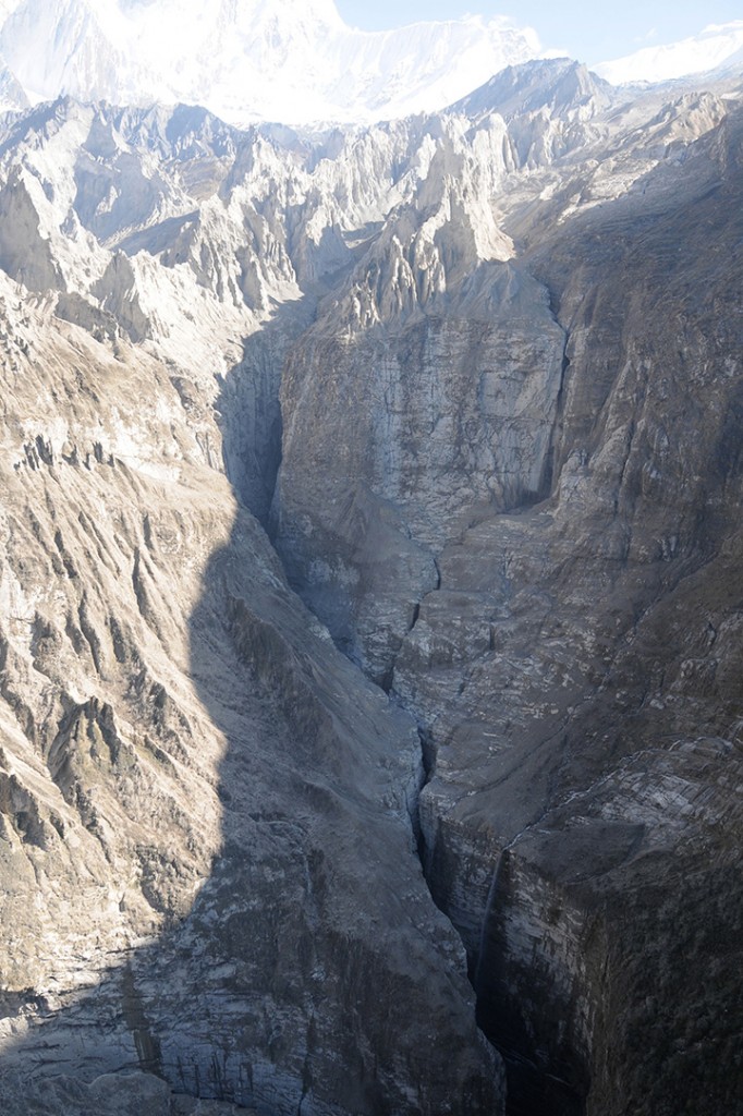
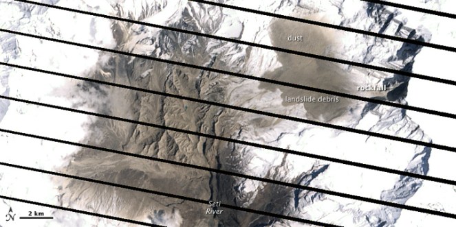
In late April and early May 2012, what was usually a roaring Seti river in Northwestern Nepal had slowed to a trickle. The milky-white turbid water had turned blue and clear. And then suddenly on May 5, 2012, the flooded river laden with slurry of sediment, rock, and water surged through the Seti valley in the Kaski district, obliterating dozens of homes and sweeping 72 people to their deaths. The floods waters were upto 30 m high at places. It reminded of the sequence of events leading to Tsunami. Questions swirled about where the water had come from and how it arrived with so little warning and that too in a non-monsoon season.
NASA Earth Observatory (acquired October 7, 2013)
The abstract of the paper by Shreekamal Dwivedi and Yojana Neupane of Department of Water Induced Disaster Prevention of Government of Nepal (presented in a conference in Nov 2012 and published in Nepal Geological Society (2013, Vol. 46)) provided some details of what happened in the floods: “Comparative Analysis of the Landsat ETM satellite images of 20th April, 2012 and 6th May, 2012 revealed that the area of about 32000 square meter of the southern ridge 1.5 kilometer away from the Annapurna IV peak failed in the north western direction. The impact of descending mass of the failed mountain from 6850 meters to 4500 meters almost vertically pulverized the ice, sediment and rock. The impact even triggered seismicity at 9:09.56 AM. local time which was recorded all over the 21 stations of National Seismological Centre. The closest seismic station at Dansing which is 32 km. south west from the area recorded the high signals for 70 minutes which corresponds to the duration of the debris flow. (The seismicity was equivalent to magnitude 3.8-4 in Richter Scale.) Lab analysis of the flood water sample revealed the density of the flow as 1.88 gm/cc. Analysis of the satellite based hourly rainfall GSMaP NRT from the period form 20th April -6th May 2012 revealed that there were just 4 occurrences of rainfall which amounted less than 1 mm/hour in the source area of the avalanche. The rainfall > 6mm/hour which occurred in the Kharapani area on 4 May was localized rainfall which did not extend to the avalanche area. Lack of systematic disaster preparedness caused huge loss of life and property even though the early warning message was received from the Ultralight pilot who was flying close to the area. The avalanche triggered high intensity floods which have similar characteristics to glacier lake outburst floods (GLOFs) have emerged as a new hazard in the Himalaya.”
Now, twenty months after the disaster, experts like Dr Jeffrey Kargel, hydrologist at University of Arizona, are in a position to throw more light what happened. Dr. Kargel has concluded that it was not just one event but a series of event that combined to produce the devastation.
NASA Earth Observatory site describes the affected landscape as: “The landscape in this part of Nepal is shaped by a cycle of landslides and subsequent erosion. As the tectonic collision of India with Asia pushes the Himalaya upward, ice, water, and gravity, assisted by sporadic earthquakes, combine to grind the mountains down. The channel of the SetiRiver itself is cut into the remnants of a much larger debris flow, perhaps 1,000 times as big. 60 to 100 meters (200–330 feet) thick, the landslide deposits are composed of the same limestone as the peaks to the north. Likewise, the May 2012 flow left behind jagged fragments of limestone, carried from the crest of the Himalaya to the foothills in a single event.”
‘Seti’ in local languages means white, and Seti is the ‘White River’, its water is glacial white, turbid and laden with sediment.
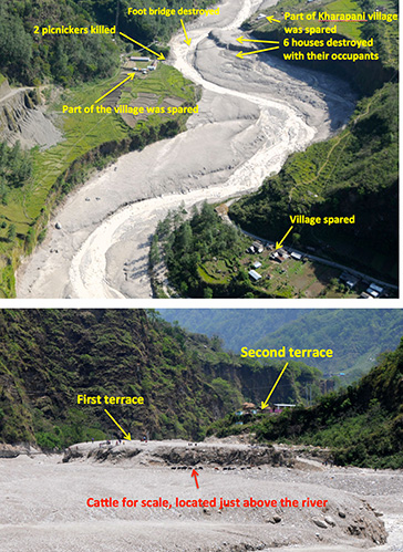
The high intensity floods in May 2012 came in waves, and the first wave alone had around a quarter of a million cubic meters of water in just a few minutes. There were about 27 waves in all over the next hours, according to eyewitnesses, so several million cubic meters of water flowed overall. As Dwivedi et al note, “The huge mass of debris along with ice chunks rushed down the river as a debris flow for 20 kilometres downstream at Kharapani in just 28 minutes (almost 12 meters/second). The flood arrived at Kharapani, where most of casualties occurred, at 9:38 AM and reached the dam of the Seti irrigation system at 10:35 AM… The high-water level at the dam weir at Pokhara was 2.15 meters. The discharge estimation based on the water mark revealed the peak as 935 m3/s (B. Poudel, personal communication). The eye-witnesses in Kharapani area reported huge ice blocks floating in the flood. They felt vibrating ground and heard very loud sound similar to flying of several helicopter together. The smell of the flood water was muddy… Kharapani was a popular spot for picnic and natural hot spring bath… Most of the causalities occurred in this area as the warning message from the Pokhara Airport tower could not reach this area”.
It is heart warming to see that many lives were saved, as Dwivedi et all write, “Capt. Alexander Maximov, the pilot of ultra-light plane of Avia Club Nepal in the morning of May 5 was in a regular sightseeing flight close to the Mountain Machhapuchhre. He noticed a huge dark cloud in the high-mountain depression (Fig. 9) and immediately turned back. He sent a message to the tower of Pokhara Airport. His quick understanding of the unusual event and timely response has saved hundreds of lives during the Seti flood of 5th May 2012. He informed the tower at 9:16 AM and the message was broadcasted through FM radio; police forces evacuated hundreds of people living and working in the bank of the Seti River. Some eye- witnesses in the field said that information about the flood was also received in Kharapani bazar by mobile calls from the people who saw the flooding in the upstream area. This message has helped many people to run to safety. However there was no organized approach of the warning dissemination in the ground.”
Video shot by Capt. Maximov from his aircraft, as the event was was happening:
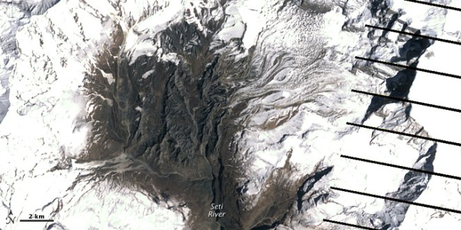
NASA Earth Observatory image (acquired Dec 22 2013)
However, the series of event started weeks before the flood with a series of rockfalls that sent debris tumbling into the SetiRiver, backing water up in the extremely deep and narrow gorge. The last of these landslides occurred just a week or so before the flood. The situation grew dire on May 5, 2012, when an unusually powerful ice avalanche and rockfall tumbled down a vertical cliff on a ridge just south of Annapurna IV Mountain peak. The total drop from the Annapurna IV ridgeline to the bed of the Seti below Pokhara is about 6,100 meters (20,000 feet) spread over a distance of only 40 kilometers. The distance between the landslide dam and sight of worst floods was about 29 km.
Prof Jeffrey Kargel, writes (http://earthobservatory.nasa.gov/blogs/fromthefield/2014/01/24/setiriverclues/), “A flash flood—what geologists call a hyper concentrated slurry because it was thick with suspended silt—had torn through some villages along the Seti River, in north-central Nepal, just north of the country’s second largest city, Pokhara. It was immediately recognized as a very deadly event, but the death toll—and a tally of those who remain missing but were clearly also killed—was not known exactly for several months. 72 souls lost. Though not large on the scale of global disasters, this event was terrifying for the fact that it seemed to come from nowhere—literally from beneath a blue sky.”
AFTER IMAGE: shows the area on May 6, 2012, roughly 25 hours after the landslide
BEFORE IMAGE: the same area on April 20. The diagonal lines are gaps in the data, due to a partial failure of the satellite.
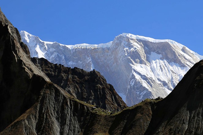
One scenario (see: http://earthobservatory.nasa.gov/IOTD/view.php?id=78070&eocn=image&eoci=related_image) estimates that roughly 22 million cubic meters of rock broke off the slope of Annapurna IV. Colin Stark at Lamont-Doherty Earth Observatory at ColumbiaUniversity said: “There’s a drop of about 2,000 meters into the canyon, so we’re talking an enormous gain in momentum. Then I think the debris ran down the canyon at speeds upwards of 30 meters per second—a guess but what we see for the landslide itself.” Stark estimated that events unfolded in a matter of minutes with no time for a temporary dam to form.
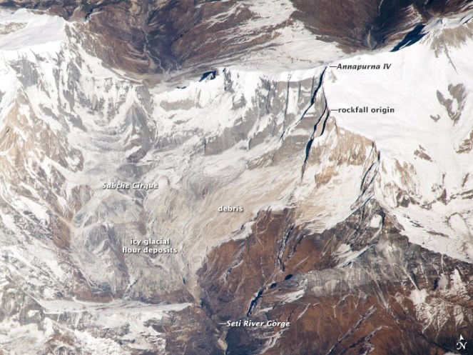
This flood appeared to behave like a glacier lake outburst flood, and the news media can be pardoned for having assumed that it was. Prof Kargel adds: “Seeing that the disaster occurred at the foot of the AnnapurnaRange, within the Greater Himalaya, probably every expert’s first thought was “glacial lake outburst flood” (GLOF), because these were common in Nepal’s Himalaya, and the news accounts of the disaster event resembled accounts of GLOFs”. However, available satellite images showed there were no such lakes. “It was, however, clearly a disaster that had its source in a high Himalayan amphitheatre-like bowl, a glacially-carved structure called the Sabche Cirque. This structure was rimmed by some of Nepal’s most famous, picturesque mountain peaks, including the storied, holy Machapuchare ( “fishtail” peak) & Annapurna IV, a 24,688 ft” mountain.
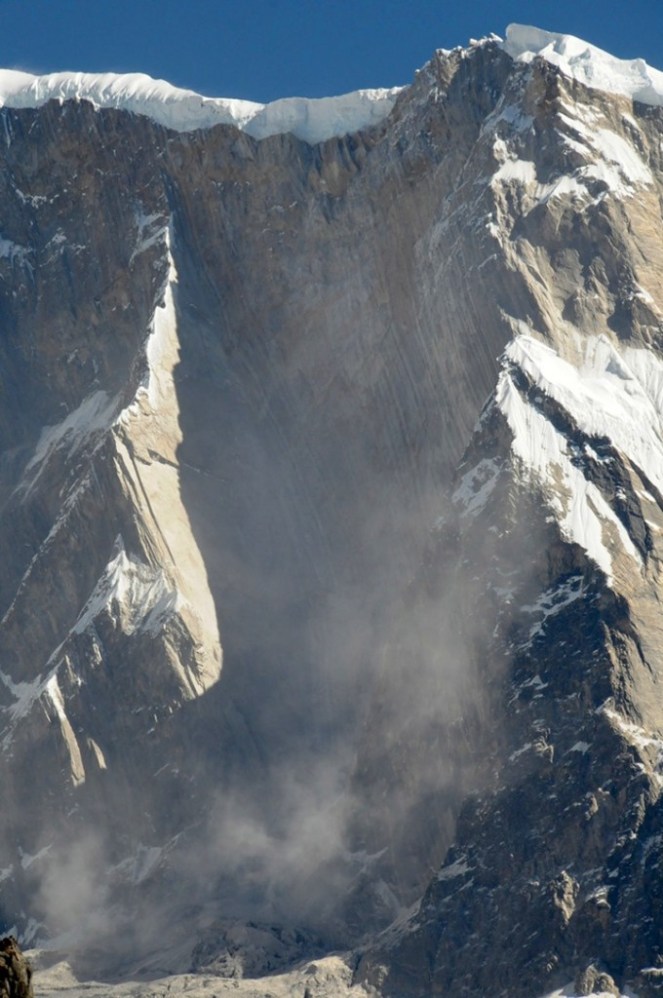
Annotated photo from Dr. Kargel
Thanks to video from winged camera of a 2 seater plane incidentally flying over the area at the time of the event, the disaster’s trigger was sourced on a ridgeline near Annapurna IV. Apparently part of this ridge—probably initially the glacier ice— collapsed, dropping ice and rock over 3000 m almost vertically onto unconsolidated rock debris (glacial moraines and ancient glacial lake silts and gravels) resting unstably in the deep bowl of the Sabche Cirque. Some of that loose debris was also swept up by the avalanche, and the mass flowed and dropped through an additional 1,500 m into the SetiRiver gorge. Indeed, the conversion of gravitational potential energy to heat could have melted roughly a tenth of the falling snow and ice by the time it reached the SetiRiver.
A view of the gorges and also the distant peaks of the Sabche Cirque and the ancient glacial deposits in between. The avalanche entered the gorge from the upper right corner of the scene. (Photo: Dr. Kargel)
One source seemed to be definitely involved, and that was a rockslide-dammed reservoir in the gorge. This was definitely not a GLOF, but was caused by a rockslide into the SetiRiver gorge, formation of an impoundment reservoir over a several week period due to damming of spring snow and ice melt, and then the final triggering event of the mighty rock and ice avalanche off Annapurna IV.
The source area for the avalanche of May 5, 2012. Annapurna IV is just off image to the upper left. (Photo: Dr. Kargel)
Warning: More such events could occur As Dwivedi et al have noted, “The southern slopes of Annapurna range have been experiencing avalanche-triggered high intensity floods also in the past. On August 15, 2003, the Madi River had experienced an unprecedented flash flood which destroyed the recently built rural road and triggered many landslides along its course and killed 5 people”.
“There are good reasons to be concerned,” Jeffrey says, “Something like this will happen again. It’s inevitable.” The Seti River Gorge is unusually prone to dangerous blockages because of how narrow and deep it is. And the same processes that triggered the spring 2012 rockfalls and avalanche are still at work. “The only question is whether future events will be as destructive or whether people in the SetiRiverValley will have absorbed the lessons of 2012 and found ways to move their homes out of the flood plain.” India should not forget that we are downstream country in Seti basin and what happens there will flow down here too.
In an earlier excellent paper on this event, Jorg Hanisch et al recommends that this event requires deep investigations and “Marsyangdi Khola, Madi Khola, Modi Khola and Kali Gandaki, all with apparent origin in the high-mountain environment of Annapurna Range (Hormann 1974; Yamanaka and Iwata 1982) should be included in the investigations… A new catastrophe of similar size would have an apocalyptic impact: about half a million people live in the valley today. A detailed investigation of the circumstances of the disaster on May 5th, especially the possible influence of global warming on the trigger of the disaster, and a reliable forecast of a potential recurrence of similar events or of even much greater scope, are urgently required. For this, the thorough understanding of the conditions, triggers and mechanisms of the huge flows in the past to compare it with the recent flood is indispensable as well.”
The proposal for a 140 MW Tanahu Seti storage project downstream of this flood event & supported by the Asian Development Bank, Japan International Cooperation Agency, European Investment Bank and Abu Dhabi Fund is questionable, says Ratan Bhandari of Nepal. Considering that the Seti River Basin is prone to such events in future, the proposal seems disastrous.
More significantly, this whole episode raises the question as to how much do we really know about the Himalayas. Uttarakhand disaster of June 2013 was a wake up call to understand the Himalayan ecosystem and its implications for future well being of the people and environment of India. However, in stead of learning any lessons, our governments in Uttarakhand (as also in Himachal Pradesh, Kashmir and North East) and at the Centre, with environmentally-challenged Mr Veerappa Moily as the environment minister, are playing into the hands of short sighted vested interests. This is also apparent in the recent decision to sanction the massive Lakhwar dam on YamunaRiver in Uttarakhand without so much as an Environmental Impact Assessment!
We still do not have full explanation for the Uttarakhand disaster of June 2013. This explanation of the Seti River Disaster in the same Himalayas, which happened just a year before the Uttarakhand disaster highlights the urgent need for more serious studies and applying precautionary principle while dealing with the Himalayas, its rivers and flood plains.
2. http://earthobservatory.nasa.gov/blogs/fromthefield/2014/01/24/setiriverclues/ This entry was posted on Friday, January 24th, 2014 at 10:34 am. See the absolutely amazing photos on the site that gives an insight into the situation in the head reaches of Seti River… possibly indicates how little we know about the catchments of our Himalayan Rivers.
7. “Cause and mechanism of the Seti River flood, 5th May 2012, western Nepal” by Shreekamal Dwivedi and Yojana Neupane, Department of Water Induced Disaster Prevention, Pulchwok, Lalitpur, Nepal (shreekamal @gmail.com), published in Journal of Nepal Geological Society, 2013, Vol. 46, pp. 11-18
8. Famous movie clip of the area, http://www.youtube.com/watch?v=Uk82ggshSKs&feature=related you can see landslide in the clip at 56-57 seconds of the movie. At this time the avalanche had not occurred yet. After taking one round the aircraft pilot has noticed the dark grey brown cloud formed by the avalanche (see the movie at 2 minute 7 seconds). This is thanks to Shreekamal Dwivedi
9. “The Pokhara May 5th fl ood disaster: A last warning sign sent by nature?” by Jörg Hanisch, Achyuata Koirala and Netra P. Bhandary, Journal of Nepal Geological Society, 2013, Vol. 46, pp. 1-10
IMPACT OF UTTARKHAND FLASH FLOODS IN MID JUNE 2013 ON LOCAL PEOPLE AT KHARADI VILLAGE (BARKOT BLOCK) IN UTTARKASHI DISTRICT RESULTING FROM A DIVERSION/ REDIRECTION OF THE YAMUNA RIVER TOWARDS POPULATED BANK OF THE RIVER DUE TO THE 8 MW GANGANI HEP. IMPACT IS ALSO THERE ON THE HEP INFRASTRUCTURE ITSELF PUTTING A QUESTION MARK ON ITS QUALITY OF CONSTRUCTION AS ON ITS SUSTAINABILITY.
YAMUNA JIYE ABHIYAAN, JULY 2013 Text by Manoj Mishra
Kharadi is a small road side market place on river Yamuna, some 40 km short of the holy shrine of Yamunotri. It is also a popular night halt site on the Char Dham Yatra route. Resultantly over the period of time a number of hotels and residential properties have come up along the road and the river side.
Redirection of the river to the left due to the project head. All Photos taken on 20 July 2013, by Bhim Rawat, Yamuna Jiye Abhiyaan
Some time in 2008-09 works, started by a pvt firm called Regency Gangani Energy Private Limited, immediately upstream of the Kharadi village for the construction of a 8 MW run of the river HEP. The works involved a diversion head, laying of pipes to convey the diverted river water and a power house around 5 km down stream of Kharadi at a place called Gangani. It is notable that the planned HEP is on the proper river Yamuna
By the year 2012, construction works had progressed to a considerable extent, when on the night of 3 August 2012 a cloud burst at Hanuman Chatti area resulted in a flash flood in the river Yamuna. Flow of Yamuna was obstructed by the diversion head of the HEP and was diverted towards its more populated left bank. This diversion swept away of around 9 hotels and residential properties of the local people at Kharadi. It also resulted in damages to the pipes laid in and near the river bed by the HEP.
If the above was not enough then on 17 June 2013, another cloud burst and heavy rains over most of higher reaches of Uttarakhand led to yet another diversion of the river and sweeping away of around 28 properties (see list at the end of this report) in the market village of Kharadi.
Washing away of structures in Kharadi some 500 m downstream from the river diversion head of the Gangani HEP by the flash flood in the river Yamuna on 17 June 2013
The Project also applied for Clean Development Mechanism (CDM) status under United Nations Framework Convention on Climate Change to get Carbon Emission Reduction Credits. Yamuna Jiye Abhiyaan and others have objected to this application at the Validation stage earlier and at registration stage now in August 2013 as the project is not only unsustainable, but its application was full of contradictions and misleading claims. The project is in any case not a sustainable Development Project, is business as usual project and hence non additional as per UNFCCC criteria. The project is also not sustainable development project, but India’s National CDM Authority, namely the Union Ministry of Environment and Forests, has never done credible assessment of this, and never rejected any application of CDM hydro projects!
Road and structures washed away by the flash flood in the Yamuna river downstream from diversion head of the Gangani HEP.Damaged pipes (meant to carry the river water to the Gangani HEP power plant some 3 km d/s from the diversion head) and the damaged approach bridge on the river
List of Hotels and residential properties destroyed in Kharadi village by the flash floods in river Yamuna made worse due to the diversion head of the HEP upstream of the Kharadi village on the night of 16 and morning of 17 June 2013 and on the night of 3 August 2012 around 11 PM made worse (as per local people) due to the Gangnani HEP structure (head) in the river upstream of the village
Property/Hotel Owner Name Father’s Name Village Name No. of Rooms
1 Neel Kanth Hukum Singh Rawat, Sri Lal Singh Khanera Three Storey, 20 rooms
2 Unnamed Jagdish, Chandar Mohan, Ajay Sri Attar Singh Khanera 2 rooms + Provision Shop
3 Yamuna Darshan Jaidev Singh Rana Sri Jandar Singh Khanera 25 rooms
4 Bhupendar Place Rajendar Singh Chouhan, Sri Narendar Singh Syalna 12 Rooms
5 Bhupendar Palace (Joint) Gajendar Singh , Sri Narendar Singh Syalna 04 Rooms
6 Bhupendar Palace (Joint) Arjun Singh, Kesar Singh Syalna 04 Rooms
7 Amit Restaurant Jogindar singh, Sri Chandan Singh Bhansadi 05 Rooms
8 Govind Palace Janak Singh Sri Ranjor Singh Khanera 12 rooms 9 Him Darshan (August 12) Atol Singh, Sri Jai Singh Chouhan Nagon Gaon 22 Rooms
10 Naveen Palace Jag Mohan Chouhan, Sri Jhoon Singh Khanera 06 Rooms
11 Naveen Palace Man Mohan Singh, Sri Jhoon Singh Khanera 04
12 Naveen Palace Dharmendar , Sri Jhoon Singh Khanera 04
13 Vijay Restaurant Vijay Chouhan, Sri Jhoon Singh Khanera 1 Hall, 1 Cottage
14 Naveen Palace Darmyan Singh, Sri Kamal Singh Syalna 07
15 Provision Singh Jagveer Singh chouhan Sri Surveer Chouhan Khanera Provision Shop
16 Ravindar Palace Ravindar Singh Sri Budhi Singh Khanera 04 Rooms 17 Kahniya Palace Shailendar Singh Sri Shiv Singh Khanera 04 Rooms + Restaurant 18 Rana Place Kitab Singh Rana Sri Surb Singh Rana Khanera 04 Rooms
19 Residence Gabar Singh Sri Sultan Singh Khanera 04 Rooms 20 Residence Bijendar Singh Sri Sabal Singh Khanera 07 Rooms
21 Residence Brij Mohan Sri Jogolia Khanera 06 Cottages
23 Residence Chojen Lal Sri Kuta Singh Syalna 04 Rooms 24 Residence Basant Lal Sri Khelan Singh Khanera 03 Rooms 25 Residence Trepan Lal Sri Sadhu Lal Syalna 02 Rooms 26 Residence Jogi Lal Sri Jhapuliyan Khanera 02 Rooms
27 Aneesh Place Aneesh Sri Janbeer Khanera 06 Rooms
28 Residence Jendar Singh Sri Keval Singh Khanera 02 Rooms
29 Residence Praveen Singh Sri Jandar Singh Khanera 02 Rooms
30 Residence Jagendar Singh Sri Keval Singh Khanera 02 Rooms 31 Narayan Place Kendar Singh Payal Sri Ram Singh Syalna 05 Rooms
32 Residence Chain Singh Sri Rompal Singh Syalna 04 Rooms
33 Residence Ispal Singh Sri Khajan Singh Syalna 04 Rooms 34 Narayan Palace (Joint) Ranbeer Singh Sri Ghayan Chand Syalna 04 Cottage
35 Narayan Palace (Joint) Chain Singh Sri Daya Ram Singh Khanera 02 Rooms + Canteen= 02 cottage (About to fall)
36 Giri Ashram Saint Giri Kharadi
37 Trishul Hotel Kandra Singh Payal Sri Ram Singh Syalna Verandah Damaged Bold entry relates to properties washed away in Aug 2012.
NOTE:
About 25 additional Households have now (after June 2013 floods) come with in the slip zone, which can now slip or get washed away any time in the event of high rainfall or another flood.
Entire Kharadi village has now been declared as disaster affected by the District Administration.
YAMUNA JIYE ABHIYAAN, JULY 2013 (Text by Manoj Mishra)
The claim of THDC, CWC and Uttarakhand Chief Minister that in absence of Tehri dam, Rishikesh and Haridwar would have been washed away is completely baseless and unfounded, nothing but a hype. Facts show that if Tehri Dam id not exist, the water level in downstream towns may have risen on June 16-17, before the levels actually rose on June 18 (as per CWC, peak level in Rishikesh was 340.8 m and in Haridwar at 295.1 m, both on June 18), but are likely to be lower than the levels of June 18 since peak flow in Alaknanda (around 11000 cumecs) was lower than that in Bhagirathi (6900 cumecs). THDC and CWC should refrain from making such claims as they are more like adding salt to the wounds that the people of the state are now experiencing and where dams and hydro projects have played a big role.
From all accounts, it is clear that peak flood in Bhagirathi River on which Tehri dam is situated, occurred on June 16 and the peak flood in Alaknanda occurred on June 17 and not at the same time. So it is not rational to add the two peaks happening at different points of time to claim that Tehri saved downstream areas. If Tehri was not there, there could have been floods in downstream a day earlier, but that does not mean peak level would have been much higher than what was the case with Tehri Dam.
From the records available on the websites of Central Water Commission (http://cwc.gov.in/Reservoir_level.htm) and Central Electricity Authority (http://cea.nic.in/daily_hydro.html), it is clear that water level in Tehri reservoir rose from 749 m on June 15 to 776.8 m on June 18 (water levels for June 16 and 17 are not available for some strange reason), this translated to increase in water storage by 652 Million Cubic meters (MCM). THDC claims that they experienced peak inflow of 244 000 cusecs and moderated that to an outflow of 14000 cusecs. To achieve this moderation for a day would take storage capacity of around 563 MCM, so it is plausible that they achieved this moderation on June 16, when Bhagirathi was experiencing peak flow.
However, as we noted earlier, the peak flow in Alaknanda happened on June 17. THDC should make public hourly figures of flow in Bhagirathi and Alaknanda on June 15-19, outflow from Tehri on each of those hours, level of Ganga at Devprayag, Haridwar and Rishikesh, so that everyone can assess the reality of their claim. Such information should in fact be in public domain in routine way.
It cannot be forgotten that:
Areas downstream of Tehri dam faced avoidable and unprecedented flood disaster in September 2010 (for details see page 20 of Aug Sept 2010 issue of Dams, Rivers & People: https://sandrp.in/drp/DRP_Aug_Sept_2010.pdf). If the dam operation is not done properly, we may be in for a repeat later this season.
It should also be recalled that Tehri is a ticking time bomb in the context of large earthquake that is imminent in the state as seismologists are telling us.( including eminent seismologists like Dr. Vinod Gaur. For more details: Earthquakes and Large Dams in Himalayas)
Landslides and debris flowing into Tehri Reservoir. 2012. Matu Jan Sangathan
People affected by the Tehri dam have still not been rehabilitated, the dam has also not been delivering the peaking power it could, as noted by Central Electricity Regulatory Authority. The dam is also silting up much faster than envisaged, reducing its water holding and power generation capacity.
In fact, CWC has failed in its flood forecasting as we made it clear earlier. Both CWC and THDC need to put their house in order rather making unfounded claims.
Central Water Commission, India’s premier technical body under Union Ministry of Water Resources, has once again failed in the Uttarakhand flood disaster. Even as the Uttarakhand state faced the worst floods in its history, CWC, which has been given the task of forecasting floods across flood prone areas all over India, completely failed in making any forecasts that could have helped the people and administration in Uttarakhand.
First principle of disaster management is prior warning. With prior warning, significant proportion of possible damages and destruction can be avoided. In that respect, one expected that CWC would play a key role in forecasting the floods. SANDRP has been monitoring CWC flood forecasts throughout the monsoon for some years. During June 15-17, when Uttarakhand was receiving the most intense rains, CWC did not make any forecasts regarding Uttarakhand. As far as the most severely disaster affected areas of Ganga basin upstream of Devprayag are concerned (these include the worst affected Kedarnath and Mandakini valley, the Gangotri and Bhagirathi valley and Badrinath in Alaknanda valley), CWC has made no flood forecasts at all this year. Same is the case regarding other affected regions of Uttarakhand including Yamuna basin including Yamunotri and Pithoragarh including Goriganga basin. What is than the role of this premier technical body tasked with flood forecasting?
The only forecast that CWC made for Uttarakhand this June 2013 were for Rishikesh and Haridwar on June 18, 2013. Even in these instances, CWC’s callousness is reflected. For example, by the fact that normally when flood forecasts are made for any site in the first place, the forecasts would be low flood forecast (where water level is between warning and danger level for the site), and only in next stage, would medium flood forecast would be made (water level above danger level). However, in case of both Rishikesh and Haridwar, CWC straightaway made medium flood forecasts, clearly missing the low flood forecasts.
In fact looking at the CWC flood forecasting site (http://www.india-water.com/ffs/index.htm), we notice that in entire Uttarakhand state, CWC has only three flood forecasting sites: Srinagar, Rishikesh and Hridwar, which means CWC would not be doing any forecasts for the most vulnerable regions of Uttarakhand in any case! Even in case of Srinagar (which actually suffered the worst floods with hundreds of damaged houses), CWC site says the Highest flood level is 536.85 m, amazingly, below the warning level of 539 m! This means that CWC has never forecast flood at that site and even if water level goes above HFL, it won’t forecast any floods since level could still be well below the warning level? Can one imagine a more callous technical body?
The callous performance of CWC does not end there. During June 2-7 this year, CWC flood forecasting site as also the flood forecasting site of NDMA which also depends on CWC, stopped functioning. After numerous emails and phone calls from SANDRP, the website started functioning on June 7, 2013 and Shri V D Roy, Director (Flood Forecasting Management) of CWC wrote to us, “Due to technical reasons, the CWC FF site was not working since 2nd June. With consistent effort, the website was made functional w e f 7th June”.
Pointing out a major blunder of CWC, we had written to CWC on June 12, 2013, “CWC forecast site reported that water level of Brahmaputra river at Neamatighat site in Jorhat district in Assam had reached 94.21 m at 0900 hrs (on June 11, 2013), which was 6.84 m above the highest flood level of the site at 87.37 m. The FF site also forecast that the level will be 94.15 m at 0900 am on June 12, 2013, that is today. Both the recording and forecast were clearly wrong, rather way off the mark. The site or the area in question or upstream and down stream levels do not match with what the CWC site said y’day.” Needless to add there was no floods in Brahmaputra in spite of such forecast by India’s highest technical body! CWC is yet to respond to our emails on this issue.
It is strange that CWC, in stead of putting its house in order, is acting as a lobby for big dams by making baseless claims about Tehri dam having saved downstream area of floods, as reported by Indian Express[i] on June 25, 2013. This is like adding salt to the wounds of the people of Uttarakhand who are suffering from the ill effects of lopsided developments including dams and hydropower projects. It would be better if CWC tries to improve its flood forecasts rather than indulging in such lobbying efforts at such times of crisis.
CWC needs to seriously consider including key sites of Uttarakhand into its flood forecasting sites, even if the the duration available for such forecasting is smaller. In times of crisis even a few hours notice can save many lives and also help save other losses.


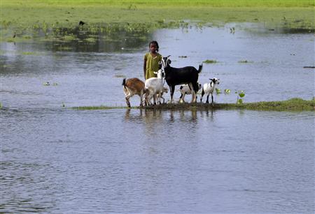
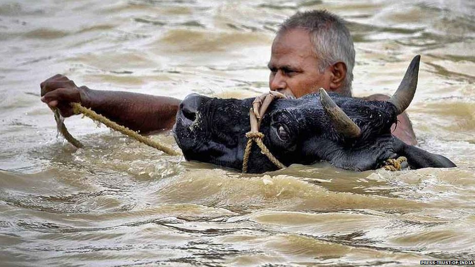
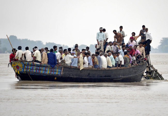

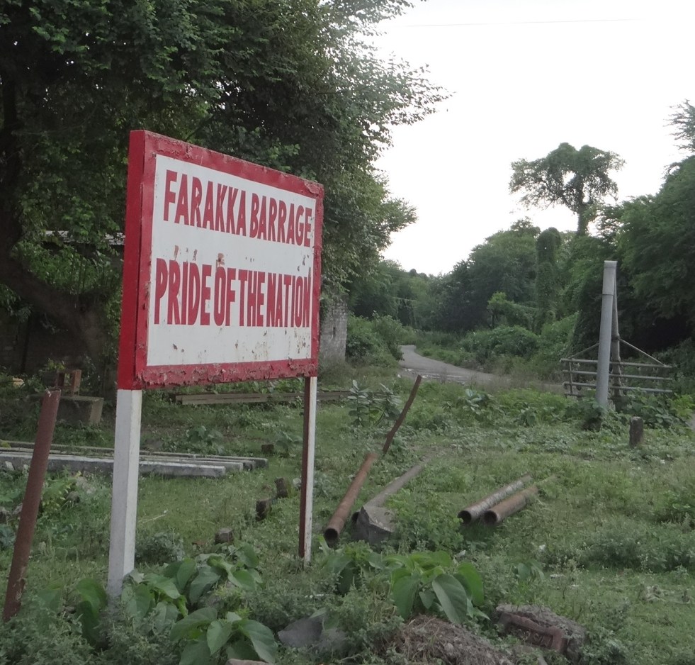
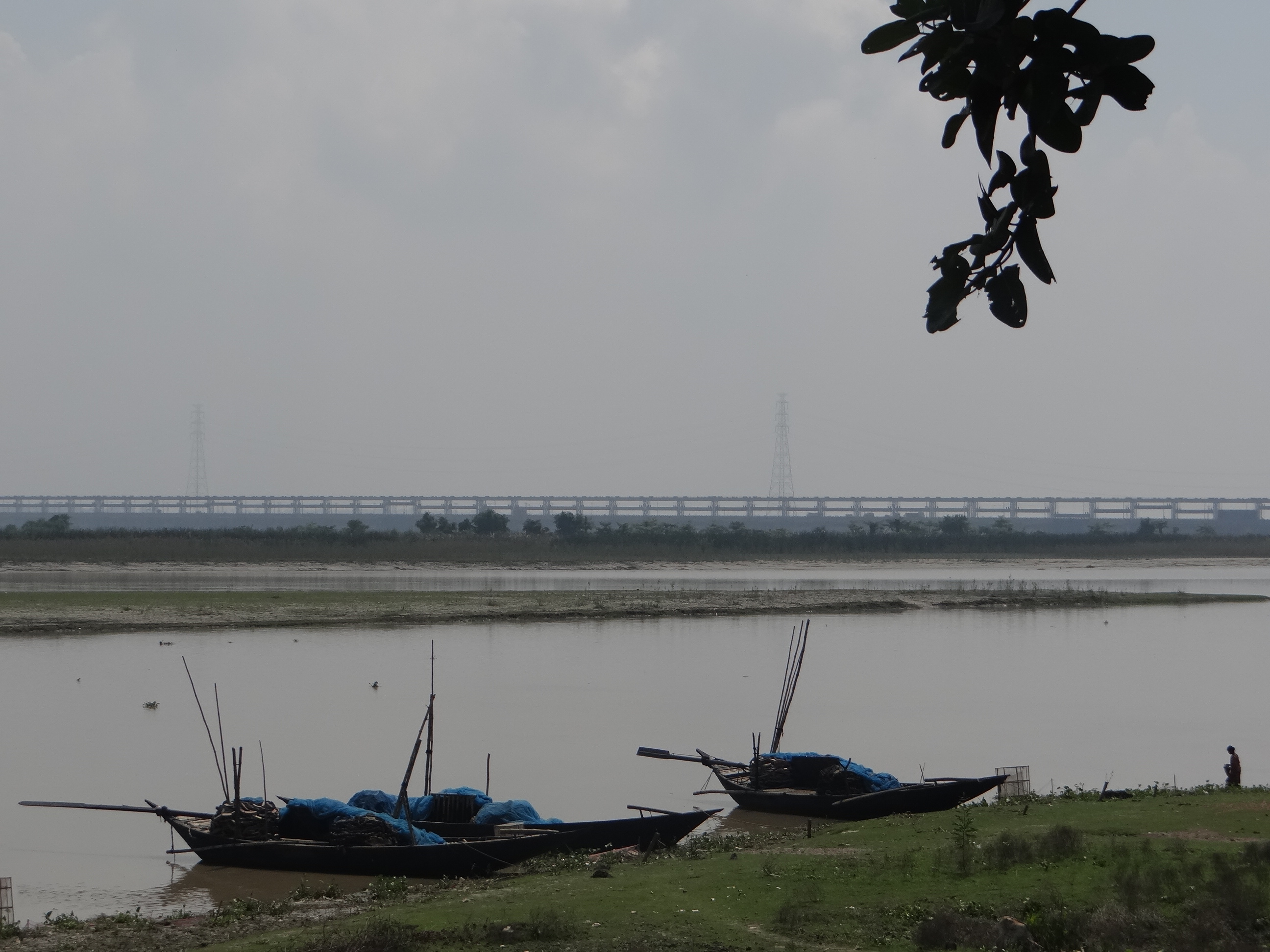

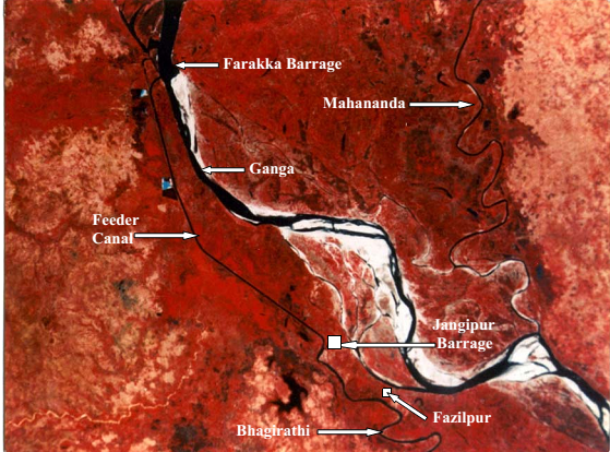
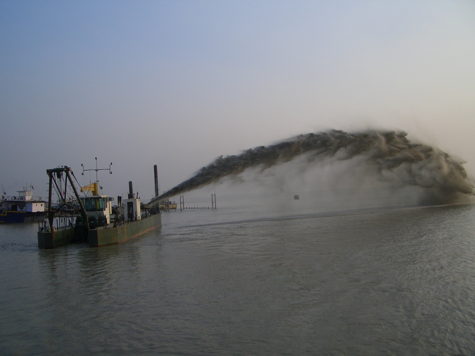
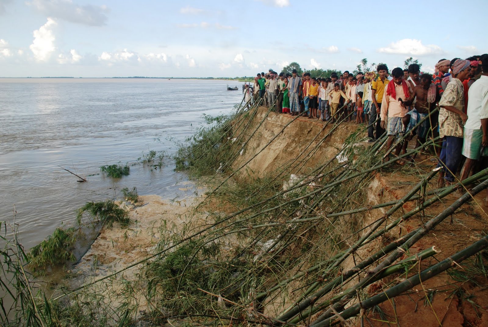

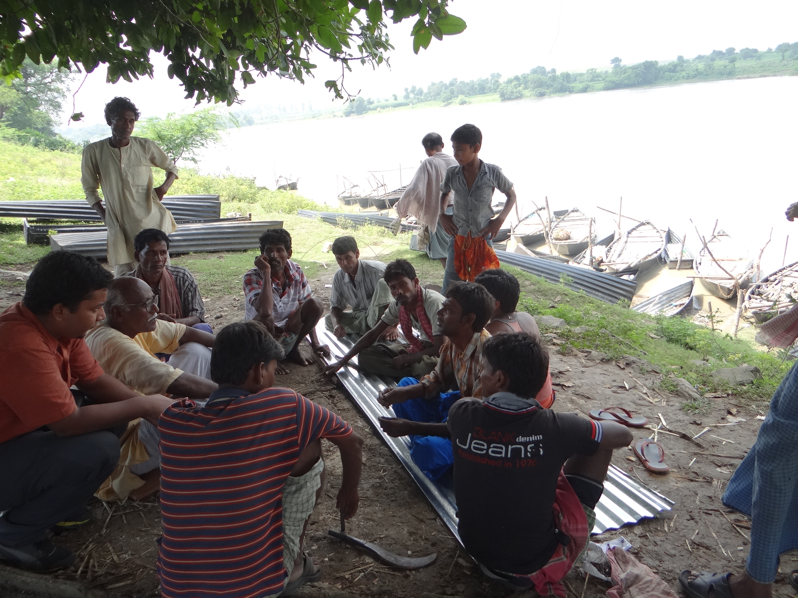
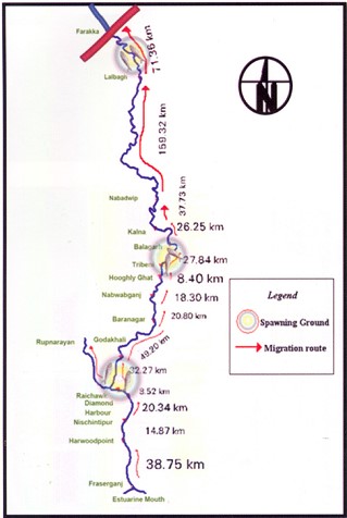 missioning Farakka Barrage in 1975, there are records of the Hilsa migrating from Bay of Bengal right upto Agra, Kanpur and even Delhi covering a distance of more than 1600 kms. Maximum abundance was observed at Buxar (Bihar), at a distance of about 650 kms from river mouth. Post Farraka, Hilsa is unheard of in Yamuna in Delhi and its yield has dropped to zero in Allahabad, from 91 kg/km in 1960s. Studies as old as those conducted in mid-seventies single out Farakka’s disastrous impacts on Hilsa, illustrating a near 100% decline of Hilsa above the barrage post construction.