“Right now, hydel is almost stalled”: Piyush Goyal (18 May 2015)
Union Power Minister makes some candid comments on Hydro: “Right now, hydel is almost stalled. We have Teesta stuck for various reasons. Subansiri, Maheshwar, Lower Subansiri, all of them have different challenges. Small hydros are facing challenges of transmission, they are facing challenges of local area problems. So, by and by, the hydro sector will need a more holistic thinking. The courts have also taken up certain matters, particularly in Uttarakhand, post the tragedy (of floods in 2013). There is the mission of Ganga to ensure that there is a reasonable flow—Aviral Ganga, which we are committed to. We are working on all of these plans… For example, Subansiri had an issue where the local population had concerns. We immediately got an eight-member very, very high-level expert committee, including Central Water Commission, Central Electricity Authority, and experts from Assam. They are all working together to see the environmental impact, structural impact, riparian state impact and riverbed impact.
DRP from SANDRP January 2015: The following developments are about dams, rivers & people, mostly from India but also some from South Asia and rest of the world. This is for the period Jan 1 to Feb 12, 2015, we hope to publish this more frequently in future. These were put up on daily basis on SANDRP Face book page: https://www.facebook.com/sandrp.in. If you want to get it regularly, you can like the FB page.
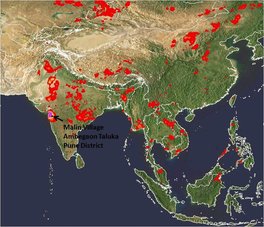
In the tragedy at a tiny village of Malin in Ambegaon, Maharashtra, as per reports till now, around 40 houses are under huge debris created by a landslide that occurred early in the morning on the 30th July 2014. The death toll till now is reported to be 44 with 150-300 missing as per different estimates. Unfortunately, the chances of survival of the missing are dim as per the Chief of Rescue operations.
Destruction at Malin Photo by Atul Kumar Kale Local activistPhoto by Atul Kumar Kale
Let us look at some key factors at play here:
VERY HEAVY RAINFALL: This region is nestled in the Northern Western Ghats which receives heavy rainfall in the monsoons. The region was receiving particularly very heavy rainfall in the week between 25th to 31st July. SANDRP had posted an alert on this on SANDRP Facebook page (https://www.facebook.com/sandrp.in) on the night of 29th July.
Cumulative rainfall in the week as recorded by NASA’s (The National Aeronautics and Space Administration of US) TRMM (Tropical Rainfall Measuring Mission, see: http://trmm.gsfc.nasa.gov/publications_dir/instant_2.html) was more than 600 mm, most of it between 29th-30th July. In fact on the 29th July, the region including Malin was shown purple in 24 hr rainfall map, which signifies the highest range of rainfall, exceeding 175 mm.
The region is still experiencing heavy to very heavy rainfall as we write this on Aug 1, 2014.
Malin receives very heavy rainfall on the 29th July, 9 pm by NASA TRMMMalin receiving high rainfall on the 30th July 2014, 9 pm IST NASA TRMM
It was surprising to read report from Down to Earth about “mere 4 mm rainfall in 24 hours” before the landslide, which is clearly not the case.
With changing climate, frequency of such high intensity rainfall events is predicted to increase, making these areas even more vulnerable to disasters like landslides.
Landslide Warning
Following the very heavy rainfall in the regions around Northern Western Ghats, extending till Gujarat, NASA’s TRMM had also highlighted this region to be strongly landslide prone on the 30thof July.
See NASA TRMM Landslide Prone Area Map on the 30th July 2014 below which highlights Bhimashankar and Malin region:
NASA Landslide potential Map, 6 pm IST on July 30, 2014
The dam connection:
The Malin village is approximately 1.5 kms from backwaters of the Dimbhe Dam, which is an irrigation project involving a big dam completed in 2000. On the 31st July, the dam held 44% of its live storage, that is about 156 MCM (Million Cubic Meters) of water. The link between water level fluctuations in dams and landslides in the rim of the reservoir and backwaters is well documented. Some geologists have also recorded increased landslides activity in areas surrounding Dimbhe Dam in the past. ( http://timesofindia.indiatimes.com/City/Mumbai/More-landslides-likely-in-5km-radius-of-Dimbhe-dam/articleshow/39314716.cms) Even if the dam was not overflowing when the tragedy occurred, it is well known that the dams can induce such landslides around the rim in view of standing water with fluctuating levels, change in drainage pattern and underground water flow pattern.
Google map showing Dimbhe Dam and location of Malin village close to the backwaters
Key salient features of Dimbhe dam: Ht: 67.21 m; Lengh: 852 m; Live Storage Capacity: 354 MCM (www.mahawrd.org); Reservoir Area: 1754.7 ha.
The role played by the dam and its operations on the geology of the region and its possible connection with the landslide needs to be investigated in depth.
Landslides are not entirely new for the region
The region has seen some landslides in the past (e.g. in 2006-7) according to Saili Palande Datar, an ecologist and historian with Kalpavriksh. According to Anand Kapoor of NGO Shashwat active for decades in the region, a landslide had occurred earlier than that, where some cattle were buried and people had to be rescued. In a massive landslide on July 23, 1989, in village Bhaja in Mawal about 60 km from Pune, 39 people were killed.
In the Western Ghats of Pune as well as Maharashtra, a number of landslide-related tragedies have happened. According to a resident of village Tikona Peth in the catchment of Pavana Dam in Mawal tehsil of Pune, a landslide took place in in her village July, 1994 after heavy rains. There were no casualties, four houses were demolished by huge rocks. In August 2004, one person died due to landslide in Male, near Pune, in 2004 again, a worker died due to landslide in work related to a tunnel for a lift irrigation scheme, in June 2005, 4 workers died due to landslide at a tunnel of Ghatghar hydroelectric project.
Role of large scale land modifications in the region
Indeed according to a landslide map developed by Dr. David Petley, International Expert on Hazards and Risks in the Department of Geography at Durham University, the entire region of Western ghats has experienced landslides.
Dr. Petley has also written about the Malin Landslide here: http://blogs.agu.org/landslideblog/2014/07/31/malin-landslide-1/.
Dr. Petley told SANDRP, “Large scale land use modification and deforestation is the issue here”. He further said: “I would hypothesise here that the very heavy rainfall was the trigger, thick weathered soil, the shape of the slope and poor management of development and of water. A proper investigation should be able to ascertain whether this is right, but such large-scale modification of the landscape should be resisted.”
From Dr. David Petley: Landslide events where fatalities have occurred. We can see that Northern Western Ghats also features regularly in the map.
Landscape modifications around Bhimashankar
Bhimashankar region, the origin of river Bhima which is an important tributary of Krishna, is a high rainfall region with spectacular biodiversity. It is also home to Maharashtra’s state animal Malabar Giant Squirrel. The region is home to a vibrant tribal community which has seen several assaults on its way of life through the formation of the sanctuary, displacement caused by Dimbhe & other Dams, recent windmill projects, etc.,
In the recent years, some of the major landscape changes occurring in this region are through mechanised terracing of slopes for cultivation as well as developments related to windmill projects on mountain tops, which entail deforestation as well as road cutting on steep slopes. Although there are no windmill farms in Malin, such farms exist in the neighbouring Khed tehsil. Plans for such farms in Ambegaon are in the pipeline.
It needs to be understood that terracing for cultivation has been a traditional occupation of the tribals in this region, as in most of the Western Ghats. Not only is it an important livelihood support factor, but it has been limited by its scale, location and implementation due to its inherent manual nature. According to Anand Kapoor of Shashwat, tribals themselves do not prefer terraces made by JCBs and other machines as these are not entirely suitable for cultivation.
However, it is also a fact that now some government departments are using heavy machinery like JCBs in their bid to push terracing program. Unscientific mechanized terracing, which comes together with muck dumping, slope instability, affected drainage etc., can play a huge role in magnifying the impacts on a naturally vulnerable, high rainfall region.
In fact, a preliminary report by the Geological Survey of India (GSI) has singled out land flattening and terracing by heavy machinery as one of the primary causes for the tragedy. As per the preliminary report, a team of GSI experts noticed cracks where heavy soil erosion had occurred. The Deputy Director General of GSI has said that these cracks are a result of improper drainage system of rainwater. The flattening of land would have affected the water drainage resulting in the cracks. He says: “The slope of the hill was flattened almost halfway for agricultural purpose to such an extent that the hilltop had become unstable. The experts have also reported excessive deforestation disrupting the ecology of the hill. Added to this was the damage caused by use of heavy machinery over two years.” The Director General and Deputy Director General will be visiting the site on the 2nd and 3rd August for further analysis.
An independent credible review of the way the land levelling activities are going on under government policies and programs should be immediately instituted and till its report is available, use of heavy machines like JCB may be minimised.
Management of the region according to Western Ghats Expert Ecology Panel (WGEEP) Report and High Level Working Group Report (HLWG)
Both reports place Malin in Ecologically Sensitive Zone I and Ecologically Sensitive Area (ESA) respectively.
An ESZ I tag by the WGEEP report regulates a number of activities in the region, with participation of local communities. The report has specifically mentioned threat of landslides in this region.
While noting the impacts of windmills in the region surrounding Malin, WGEEP notes: “Apart from substantial forest destruction (including Forest Department estimates of about 28,000 trees being cut) via wide roads cutting huge swathes through Reserve Forest, the wind mill project has triggered large scale erosion and landslides through poor construction of roads with steep gradients, and all this rubble is ending up on fertile farmland and in reservoirs of tributaries of the Krishna.
The Forest Department is colluding with wind mill project operators in also illegally denying citizens access to these hills. Boards and check-posts have been put up by the company, falsely claiming to be authorized by the Forest Department. There are many traditional forest dwellers on these hills. Not only are their rights under the Forest Rights Act not being recognized, they are being illegally restrained in their movements on hills they have inhabited for centuries.”
If the WGEEP was accepted by the MoEF and state governments, this would have led to a more people-centred and ecologically-sound management of the Western Ghats region, but Maharashtra has been vehemently opposing WGEEP on the most unjustified grounds and the MoEF too has been busy downplaying the WGEEP.
While HLWG did include Malin village in its list of Ecologically sensitive Areas, however, this ESA tag did not mean much for the region it only regulates mining and red category industries. Most of the development activities that might threaten the region are not regulated by the HLWG. More importantly, HLWG has no role for the local communities in democratic decision making. There is also no mention of this region being landslide-prone in the HLWG, whereas the WGEEP specifically highlights this issue.
It is clear that HLWG is not much help for the region in avoiding tragedies like the Malin tragedy, but WGEEP report certainly would have helped.
Way forward
Northern Western Ghats which are characterized by heavy rainfall, rich biodiversity and predominant tribal population need more sensitive management approach than what it is subjected to right now. Although WGEEP had paved way for a more democratic, equitable and people-centred management of the region, the report was hidden, downplayed and finally rejected by the state as well as the central government. Episodes like Malin highlight the vulnerability and complex inter-linkages that affect the region which require a long term planning vision, integrating a number of components.
Despite this, several ill-conceived projects like townships, windmill farms, large dams and river linking projects like Damanganga-Pinjal and Paar Tapi Narmada are proposed in the region. Close to Bhimashankar region, Mumbai Metropolitan Regional Development Authority (MMRDA) as well as the Greater Mumbai Municipal Corporation are pushing more than 12 large dams. Some of these dams entail huge tunnels under the mountain ranges of Western Ghats. Despite the several risks and impacts, many of these massive dams may also escape scientific Impact Assessments or public hearings. These projects needs to be opposed and urgently dropped as there is little justification of the projects in view of huge number of options available in the cities for which these dams are proposed.
Similarly, Maharashtra Government has plans to build three huge hydropower dams in the Velhe and Mulshi region, which also falls in the Pune District. Velhe region has already seen slope instability and also falls in Seismic zone IV, making any such development highly risky there.
Let us hope that the heart-breaking tragedy at Malin is a wake-up call for all of us, paving way towards more sensitive,responsive, democratic and sustainable management of the Western Ghats. As a first step, the state and central government need to accept and implement the recommendations of the WGEEP immediately in Malin and for the entire Western Ghats.
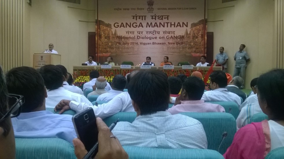
The one day Ganga Manthan[1] organized by the National Mission for Clean Ganga on July 7, 2014 was described by Union Minister[2] Sushri Uma Bharti & Union Minister[3] Shri Nitin Gadkari as “Historical”. The Union Environment Minister, who has one of the most crucial role in achieving a rejuvenated Ganga, was supposed to be there, but could not come at any stage.
I attended the full day meeting with a lingering question: Will this help the river? Even some of the ardent skeptics said that Uma ji has emotional, spiritual and religious attachment with the cause of Ganga.
At the conclave attended by close to a thousand people, the story of how Ms. Bharti came back to the BJP party about a year back to work for the cause of Ganga, and how she was promised a year back that if their party came to power, Ganga will get a separate ministry and she its charge was narrated repeatedly by both Ms Bharti and Mr Gadkari at least twice. It was also stated that the government has the commitment, the will & all the money to make the Ganga clean (Nirmal) and perennial (aviral). There were also repeated statements by both ministers about the officials being so committed to the cause of Ganga. These, in essence, were the basic positive assets of this government to achieve Ganga Rejuvenation.
While it was good to see large gathering involving various sections of the society, including many independent non government voices, missing were some key stakeholders: Ganga basin state governments, farmers groups, Ministry of Urban Development, fisher-folk groups, boats-people representatives. Another key constituency missing was Ministry of Agriculture, since agriculture is major user of water & irrigation and responsible for water diversion and at the same time major non point source polluter through use of chemicals and fertilizers.
Rejuvenation does not mean just nirmal and aviral But if the task is Rejuvenation of River Ganga, are these assets sufficient? What exactly does Rejuvenation of River Ganga mean? There were no answers to this question at the meeting. The government did not even seem bothered about these questions. Are Nirmal and Aviral Ganga sufficient objectives to achieve Rejuvenation of Ganga? The answer is clearly no, for, even a pipleline or canal carrying perennial flow of water can claim that distinction. A rejuvenated river will need much more than that, but the government has nothing else to offer for a rejuvenated river.
Even for Aviral Ganga, the government had absolutely nothing to offer. In the information package shared with the participants, the only thing relevant to Aviral Ganga was the extended summary of draft “Ganga River Basin Management Plan” being prepared by consortium of seven IITs in collaboration with some 11 other organisations. This is led by Dr Vinod Tare of IIT Kanpur. While standing with Dr Tare and Rajendra Singh of Tarun Bharat Sangh at the lunch, I said, the problem with Ganga is not of technology[4], but of governance. Despite being a proud IITian myself, I have no hesitation in saying that IITs do not have expertise in governance issues, so how can the IIT Consortium help in fix a governance problem? Having read the full Draft Plan of the IIT consortium, it only further strengthens the view that it was wrong decision of Jairam Ramesh to give this task to IIT Consortium.
Agenda for further destruction As a matter of fact, while this government has yet to take a step that will truly help rejuvenation of Ganga, they have declared their agenda that will possibly further destroy the river. This was clear on June 6, 2014, within ten days of new government taking over when a PIB press release[5] announced, “Shri Gadkari said it is proposed to conduct dredging to provide a width of 45 meters and for a three (3) meters draft (depth) to enable transport of passengers and goods between Varanasi and Hoogly on river Ganga in the first stage of its development and eleven terminals are proposed to be constructed along the banks. He said barrages are proposed to be constructed at every 100 Kms.” This was a shocking and arrogant announcement. There is nothing in public domain about this Rs 6000 crores plan, no details as to what exactly is planned, where the barrages are planned, why are they needed, what are their environmental impacts, what are the social impacts, what are the riverine impacts, what is the cost and benefits, who will pay the costs and who will reap the benefits, where is public consultation….there is absolutely nothing in public domain and here is a nine day old government declaring such massive plan! By July 7, 2014, the PIB Press Release declared that the depth will now by 5 meters and not three announced earlier. The PIB PR now said, “He (Mr Gadkari) said barrages are proposed to be constructed at every 100 Kms on the river. Shri Gadkari said his Ministry has sent a proposal in this regard to World Bank for the development of Allahabad- Haldia corridor.”
The minister possibly does not know that there is just one barrage on the Allahabad-Haldia 1500 km long stretch, namely the Farakka barrage and Bangladesh had threatened India to take the matter about building this barrage to the UN! Moreover, that barrage, everyone accepts, has not even achieved the basic objective it was supposed to achieve, namely navigability of Kolkata port, but has had many other severe impacts.
At Ganga Manthan, Mr Gadkari dropped a bombshell[6] when he said this plan is already in advanced stage of appraisal with the World Bank! He said the government hopes to get Rs 4000 crores from the World Bank!! The World Bank has zero track record in achieving any clean river anywhere in the world, after spending billions of dollars every year. In India itself it stands guilty of destroying many rivers. A more inauspicious start to the Ganga Manthan possibly could not have been possible. At the Ganga Manthan itself, there was opposition to this plan, as The Hindu[7] has reported.But Ms Uma Bharti finds nothing amiss about this as was clear by her answers at the press conference. But what about at least some semblance of participatory democracy?
Business as usual at NMCG and NGBRA will not help In reality, this is not all. While this Manthan for Ganga Rejuvenation is happening, the NMCG and NGBRA[8] (National Ganga River Basin Authority) go on with their work in business as usual fashion. So in Varanasi, the Uttar Pradesh Jal Nigam is going about its task of floating and examining the bids for five-part sewer laying and Sewage Treatment Plants with the help of JICA money. In Kanpur, the effort to divert several streams to Pandu is going on. In Allahabad, “the draft final ESAMP sewerage works for sewerage districts” A & C could be found on the NGBRA website. In Patna, the World Bank is funding the sewerage projects of Pahari in Patna & river front development and the draft social and environmental impact assessments could be found on NGBRA website. All of this (except the Varanasi packages, which are funded by Japanese aid agency) is going on under USD 1 Billion World Bank Funded NBGRA project.
So the business as usual that is going on for 40 years is now going to help rejuvenate Ganga!
The NMCG announced that the Manthan, a “National Dialogue on Ganga”, was supposed “to facilitate interaction with various stakeholders”, “to discuss the issues & solutions to the task of Ganga Rejuvenation”, “to prepare road map for preparation of a comprehensive plan”. The website said the Ganga is “holiest of Rivers”, “purifier of mortal beings” & “living godess”, but now “seriously polluted” and in “extreme environmental stress”.
Where is the dialogue? However, the way the meeting was organized, there was essentially no dialogue. After the inaugural plenary session, the participants were divided among four groups: 1. spiritual leaders, 2. environmentalists, NGOs, water conservationists, 3. scientists, academicians and technocrats, and administrators; 4. public representatives.
I went to the second group and there, when someone pointedly asked, if there is any representative of the government present, there was no response! In fact it was positively shocking that the first panel member that spoke in this group was Dr Arun Kumar of AHEC (Alternate Hydro Energy Centre) whose work on Ganga basin cumulative impact assessment is so discredited that even the official agencies like the Expert Appraisal Committee of MoEF, the Inter-ministerial Group on Ganga, the Expert Body appointed by the Supreme Court after the June 2013 flood disaster and the Supreme Court itself has criticized it or found it unreliable. NMCG has discredited itself by appointing such a person to give an overview of achievement of Ganga Action Plans.
Ms Bharti apologized in the beginning for hurriedly-called meeting. But the least she could have ensured was a credible process that will ensure that the officials have to show application of mind to the various suggestions received and conduct of the meeting in credible and confidence inspiring way. But the meeting did not inspire confidence that there will be any credible process that will ensure that there is application of mind to the various inputs given. Many of the participants did not have any opportunity to speak.
Recommendations for the government on Ganga
1. Make an honest effort to learn from the past. Why have the efforts of last 40 years since the passage of Water Pollution Act 1974 not helped Ganga? Similarly why did the GAP I, NRCP, GAP II, NGBRA not helped make the Ganga clean (nirmal) or perennial (aviral)?
2. Understand & recognise that Ganga is a river and what are the essential characteristics of a Ganga that it needs to rejuvenate it as a river. At Ganga Manthan, in post lunch session in the room where the fourth group for public representatives was sitting, I was sitting next to an official of Ministry of Water Resources and I casually asked him does the ministry of water resources understand what is a river? He first said yes, but when I said you are only dealing with water and nowhere in your work have we seen any value for rivers, he said ok, but we can do it in collaboration with MoEF. The trouble is, even MoEF does not understand rivers. [It was also strange to see in this session Mr Madhav Chitale (former Water Resources Secretary) describing Tennessee Valley Authority of 1933 as an effort to clean the river! Such misrepresentation going unchallenged was shocking.] It should be remembered that it is this ministry of water resources through which Sushri Uma Bharti has to achieve a rejuvenated Ganga!
3. Ganga is not 2525 km long river: We kept hearing this sentence that Ganga is 2525 km length of river and Mr Bhurelal in fact said we need to limit ourselves to discussing how to make this stretch clean. The trouble is, if the tributaries are not healthy rivers, how can the main stem of Ganga be rejuvenated? As Manoj Misra of Yamuna Jiye Abhiyaan said, Ganga is not 2525 km, but much more than 25000 km including all the tributaries, as Yamuna is not 1400 km long but 13470 km long including all the tributaries.
4. Ganga in Mountains: Learn the lessons from Uttarakhand disaster, that affected the headwaters of the Ganga river. The Expert body constituted by the MoEF under Dr Ravi Chopra has a lot to say there. Revisit all the existing, under construction and planned projects in the whole basin.
5. Farakka barrage: It is well known that the barrage did not serve the basic purpose it was created for, namely making the Kolkata port navigable. But it has created such havoc in upstream and downstream for millions of people that some of the Bihar MPs of previous Lok Sabhas talked about decommissioning of the barrage in the debate on Ganga. But this government wants to make many more barrages! First do a post facto assessment of the Farakka barrage and its current costs, benefits and risks.
6. Formulate an Urban Water Policy: The footprint of the urban areas on the rivers is increasing in multiple ways, but we have no urban water policy. Some key elements that such a policy will include: Reducing transmission & Distribution losses, water audit from RWA upwards, Rainwater harvesting, decentralised and eco-friendly ways of sewage treatment and recycle, groundwater recharge and bottom up management, demand side management, protection of local water bodies, protection of riverbeds, floodplains and forest areas & democratisation of the Urban water utilities. As the working report for the 12th Five Year Plan on Urban water said, no Urban areas should be allowed to have external water till they exhaust their local potential, including recycling of the treated sewage and other demand side and supply side options. The footprint of the urban areas will increase exponentially if we do not urgently on this front.
7. Agriculture is the biggest user of water and our government encourages use of chemicals and pesticides in agriculture. Most of these chemicals end up in water bodies including rivers. If we do not want our rivers to be dumping grounds for these chemicals, the government should encourage organic farming. Similarly, in stead of encouraging water intensive cropping patterns and methods, government needs to encourage low water use crops and methods like System of Rice Intensification (SRI). SRI is applicable for many crops and can reduce water need by upto 50% and yet increase yields and incomes of farmers. But the government has shown no interest in encouraging SRI. Such methods can free up a lot of water for the river. Similarly, under the influence of powerful sugar lobby, we are producing more sugarcane and sugar than we need and than we are exporting the same at subsidized rates! So essentially we are exporting water at huge subsidized rates, that too from Ganga, but we have no water for the river!
8. Irrigation is the biggest user of water. At Bhimgoda, Bijnor and Narora barrages, we are diverting almost all the water in the river for irrigation. But we have no water for the river. If we change our water resources development and agriculture policies, it is possible to restrict these diversions to 50% and release the rest for the river. We need to review all this.
9. The IIT consortium report is seriously flawed and is not likely to help the river.
10. We need to define the path of the riverbed or right of way for the river, based on its need to carry 100 year flood and silt. In absence of such a defined space for the river, there are a lot of encroachments. There is also no river regulation law to regulate this riverways land. This is urgently required.
11. Our Pollution Control Boards and related mechanism is not known to have achieved a single clean river or nala in 40 years of their existence, anywhere in the country. This is because of the completely non transparent, unaccountable, non participatory and exclusive bodies, where people whose lives are affected by the pollution have no role. A complete revamp of this is required to make its management inclusive from block level upwards, and answerable to the local people through clearly defined management system.
12. One of the major reason for the failure of the GAP, NRCP and NGBRA is that their functioning is top down, with absolutely no clearly defined norms for transparency, accountability, participation and inclusive management. Unless we completely change this, no amount of money, no amount of technology, no amount of infrastructure or institutions is going to help the Ganga. We need management system for every STP, every freshwater plant, every city and town, every 3-5 km of the river, every tributary and so on. At least 50% members of the management committees for each of them should be from outside the government, including community members. The people whose lives and livelihoods depend on river including fisherfolk, boatspeople, river bed cultivators, local sand miners, communities depending on river for different water needs have to be represented in such management system. That will also create an ownership in river rejuvenation effort. This is also applicable to urban areas and all the tributaries.
13. This is also true for our environmental governance of dams, hydropower projects, flood control projects, water supply projects, and so on. Today there is no credible environmental management at planning, appraisal, construction, operation or decommissioning stage.
14. River of course needs water. Urgently. Chart out a road map to achieve 50% of freshwater releases from all dams and barrages in two years. Also no sewage water or effluents entering the river in two years.
In the concluding plenary, after listening to the reports from four groups (there were a lot of positive and useful suggestions there), Ms Uma Bharti and Mr Gadkari said that they won’t make any announcement today but they will ensure that the good suggestions that have come will be given to the decision-makers who will create a road map. This is very vague and unconvincing process with no credible transparency. The least the ministers could have assured is a confidence-inspiring process that would transparently ensure that the decision makers have applied their minds to the suggestions. But even that was not promised.
Despite this seemingly gloomy outcome, considering that the NMCG has invited[9] suggestions even after the meeting, I am going to send this blog link to them and wait for their response! Ganga definitely needs a lot of sewa from all of us if the river is to have any better future.
[2] Union Minister of Water Resources, River Development and Ganga Rejuvenation
[3] Union Minister of Road Transport & Highways, Shipping, Rural Development, Panchayati Raj, Drinking Water & Sanitation
[4] It’s worth noting here that Mr Gadkari seems to have abiding faith in technology, he said that this is an age of technology and there are technological solutions for all problems! This possibly shows where we are heading!
[5] Title: “Development of River Ganga for Tourism, Transport and to make it Environment Friendly”
That sounds like a rather innocent question and I was asked to write an article, addressing it. But before we go into that, let us try and understand a few things. Firstly, what is a River? Let us first try and understand that.
There is no single definition of this complex entity. For every definition, there is something more a river does.
Take the example of the one of the most complex rivers of all, the Ganga that we think we know. Before being a religious entity cultural icon, etc Ganga is, first & foremost, a River. A perennially flowing river like Ganga flows all the time. But that flow is not constant. It changes from day to night, from one day to another, from one season to another, one year to another, from one place to another.
And then, the Ganga that we know is not only a single river but a collection of rivers. So Yamuna, Bhagirathi, Alaknanda, Mandakini, Dhauliganga, Pinder, Ramganga, Kali, Tons, Gomti, Ghaghra, Sone, Gandak, Budhi Gandak, Kosi & Mahananda are some of the major tributaries that directly meet Ganga. Each of them is a river in its own right.
The Ganga Brahmaputra Basin Photo from: Wikimedia Commons
Take Yamuna for example. Some of its major direct tributaries include: Tons, Giri, Som, Sahibi, Hindon, Chambal, Sind, Betwa & Ken, each of them are again significantly big rivers.
Take Chambal, some of the major direct tributaries of Chambal include: Parbati, Kali Sindh (Lakhundar, Ahu, Parwan are some of the tributaries of Kali Sindh, Newaj is one of the tributaries of Parwan, Dudhi is one of the tributaries of Newaj), Banas, Ider, Retam, Sau, Kshipra, Chhoti Kali Sindh, Cham, Siwana, Kural: each of which is a river by its own right.
Take Parbati: some of the major tributaries of Parbati include: Papnaus Ajnal, Sewan Paru, Utawali, Paraparwa, Mawal, Tem, Bhader, Gochi, Gaumukh, Sunk, Negri, Chopan, Uproni, Duhral, Andheri, Beram, Kosam, Ahelil and Sukni. These are all rivers too!
We can go on like this much longer. But such is a vast network of rivers that we call Ganga.
Secondly what flows in a river is not just water, though most governments, official agencies & engineers see the rivers as channels of water. Flowing water is surely a major visible defining component of a river. But even a canal or a pipeline can claim that. But unlike a canal or pipeline, a river carries dissolved matter, suspended matter, bed load, microorganisms, many levels of aquatic flora and fauna.
Thirdly, a river is a connected entity. It is connected with upstream and downstream river, biodiversity & landmass, the terrestrial land & life, underground geology and groundwater aquifers and is also connected with the floodplain. Perennial rivers like Ganga meet the sea forming a delta and this connection is vital for the river and as well as the sea. The connections are so strong that a river provides a report card about what is happening upstream and downstream, if read carefully.
From: The River continuum Concept. Species in India will be different, but this represents how biological entitites in a river are linked to each other through a number of processes including nutrient spiralling Oxbowriver.com
This is admittedly a partial description of a river, limited by the constraints of an article or blog. This is also a bit simplistic description of how humans deal with rivers, since there are exceptions. But this provides a broad direction of our journey with the rivers.
from : lakeconesteenaturepark.com
Apart from its many functions like ecological, hydrological, geomorphological ones, a river is also connected with the human society along the banks. The connection with human societies has been as long as the humans have existed. This connection is not really necessary for the river to survive, but we cannot say the same about human survival. Humans cannot survive without the rivers, though is doubtful if the human society understands or even acknowledges that reality.
More importantly, till about a century ago, our interaction with the rivers did not endanger the existence of the rivers themselves. But what we have been doing in last century has created existential threat for rivers. This threat comes in the form of big dams, diversions, chemical pollution from agriculture and industries, large dose of sewage pollution at major urban centers, encroachment on floodplains, deforestation, unsustainable groundwater use, riverfront developments, embankments, and climate change.
What humans have done to the rivers in last century can possibly be described as Terraforming (one of the grandest concepts in science fiction in which “advanced” societies reshape entire planets to suit their needs). Or what some geologists describe as Anthropocene, meaning a new geological age of humans to suggest that humans are now a planet transforming force.
It seems humans have stopped valuing the rivers as they exist in nature and decided that they can stop, bend, tunnel, channelise, divert, encroach, pollute the rivers. So when we build a dam, we do not put any value to the destruction of river & destruction of the services provided by a river that entails in the process of building the dam.
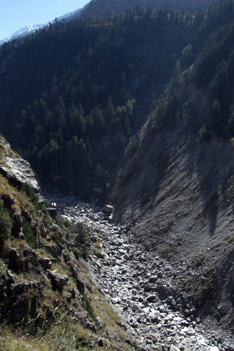
But let us get back to Rivers & what dams do to them. A river, by definition, must flow freely. A dam stops the free flow of river, and impacts the river in the most fundamental ways. In India when we construct a dam (e.g. Tehri), a hydropower project (e.g. 400 MW Vishnuprayag project on Alaknanda in Chamoli district in Uttarakhand) or diversion (Lower Ganga – Bhim Goda at Haridwar, Middle Ganga – Bijnor and Upper Ganga-Narora barrages), we do not have to leave any water for the downstream stretch of river. So complete drying up of the rivers for most of the dry months by these structures is the first direct impact of these structures on the river. To put it mildly, that action practically kills the river. Upstream of the dam too, the river gets killed, for immediate upstream there is stagnant water and further upstream, the river has lost its connections with the downstream river!
Dry Baspa River downstream Baspa II Dam, Himachal Pradesh Photo: SANDRP Partners
This is because these structures not only stop the flow of water to the downstream areas, they also stop flow of everything else that was flowing in the river: the silt, the nutrients, the sand, the organisms, the flora, fauna, and severe every one of the connections of rivers we described earlier
And imagine when a river has to face such death every few kilometers in its journey!
Density of dams in the Upper Ganga Basin Map by SANDRP
That is not all. As the river continues its journey, if the tributaries are flowing reasonably freely, there is some chance for the river to recover some of its defining characteristics. But we have dammed most major tributaries too.
To top it, we also have other elements that help kill the river, like pollution, encroachment, abstraction, etc, as described earlier.
And remember just about a century back Ganga and other rivers were not in such a bad shape. This is an achievement of less than 100 years.
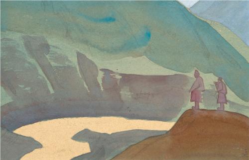
Chandra Basin in Himachal Pradesh depicted by Nicholas Roerich in 1932. The same Chenab Basin now witnesses one of the highest dam densities in Himalayas. From: WikiArt
Some people will read in this a plea to go back by those 100 years. That is not possible, and we all know that. But there are other ways to deal with the rivers. Human society can take what is needed for the society, without destroying the river.
Rivers are again in the news, though so far only for symptomatic reasons. The new government at the centre has renamed the charge of water resources minister to Minister of Water Resources, River Development and Ganga Rejuvenation. There is fundamental contradiction within this name plate and we have in fact yet to see this nameplate.
There is also a lot of discussion about rejuvenation of Ganga, with the Prime Minister promising the people of Varanasi Parliamentary constituency that he will rejuvenate Ganga. There is no clarity about how he plans to go about in achieving that. His claim during elections that Gujarat Government’s Sabarmati Riverfront Development provides a model for this is clearly a non-starter. Sabarmati has water only in 10.4 km of the river stretch that flows through Ahmedabad. If you go upstream of this stretch, you will find a dry river in most non-monsoon months and if you go downstream, you will find a river more polluted than Yamuna in Delhi. And even the water that one sees in this 10.4 km stretch is not the water from Sabarmati river basin, but is taken from Narmada River via Sardar Sarovar Canal! Pertinently, Ahmedabad or Sabaramati has no right over that water: the Sardar Sarovar Project has been built and justified in the name of Gujarat’s drought-prone areas like Kutch and Saurashtra.
The nameplate-changing business also extended to Union Ministry of Environment and Forests, its name changed to Union Ministry of Environment, Forests and Climate Change, though here again the new nameplate is yet to be seen. Unfortunately, all the noises that we have heard so far from this front seem to give primacy to growth rather than environment or forests or climate change! The new environment minister has yet to say anything about river protection, but he is already talking about river linking!
So is there a hope for rivers in this new establishment, going beyond the symbolic name changes? Here one is reminded of a meeting, where one of us (HT) was invited a few months before the elections, to discuss the state and fate of Yamuna River in Delhi. When HT started speaking, he started by asking what is a river? Is it just a source of water as engineers see it? Following a sudden change in program, Sushri Uma Bharati was the chief speaker at the meeting and when it was her turn to speak , she actually tried to understand that question and tried to find an answer to it: what is a river? Her becoming the Union Water Resources Minister also raises hopes since she had been campaigning for Aviral Dhara (Continuous flow) of the Ganga and against building of dams and hydropower projects in Uttarakhand. We hope that she will realize that impact of dams and hydropower projects on rivers is similar, if not same everywhere.
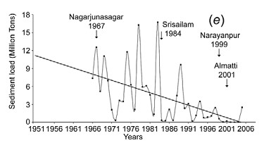
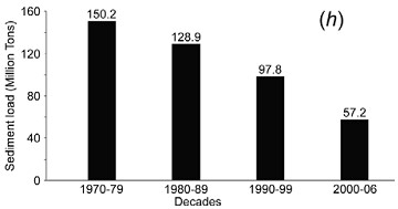
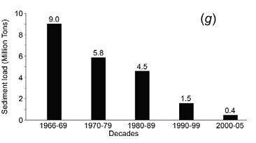
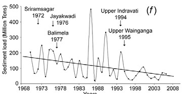
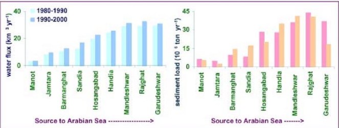
Ms Bharati is also minister of river development and Ganga Rejuvenation. The question, What is a river? becomes even more relevant in that context. A river is possibly the most complex ecological entity and we still do not understand fully how to define a river. But here we would like to highlight that river is a lifeblood of the ecology and carries so much more than water. One of the key elements that river carries is silt or sediment (although there is a slight difference between the two, we will use it interchangeably here).
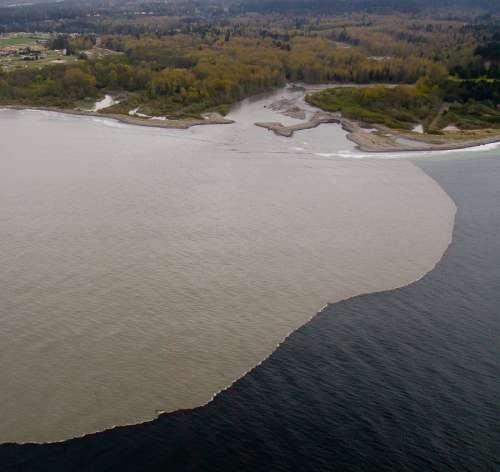
The rivers carry silt from various points in their journey from the hills, to the deltas where most major rivers meet the sea. In this journey, the type, quantity, movement of silt varies with place and time. The silt comes in various forms, from suspended matter to fine silt to coarser sand. It is the transfer of silt from upper catchments to the plains that helps build fertile and alluvial flood plains like the Indo Gangetic plains.
The flow of sediment through rivers to the delta also protects the deltas, which are very highly productive & biodiversity rich ecosystems, population centers and agriculturally fertile areas. Deltas are constantly facing the threat of erosion by sea. In this fight against erosion by sea, the sediment brought by the rivers helps the deltas in a major way. Sediment flow to delta becomes even more important when sea levels are rising in changing climate.
However, when we build dams, hydropower projects and diversion structures on the rivers, we completely change the silt flow pattern in the river. The dams arrest the silt and hydropower projects and release silt free water in the downstream. The erosion capacity of the silt free water is greater, and the additional erosion they cause in the immediate downstream may not compensate for the silt trapped in the dams. The run of the river hydropower projects may release silt annually or more frequently and also on daily basis from desilting chambers, but the pattern of transport of the silt again completely changes. Moreover the dams and diversions completely change the character of flood-flow in the downstream area, when it is established that floods are the most important sediment-transporting events. All these changes have huge impacts in the riverbeds, in the floodplains and in the deltas. And most worryingly, we do not understand these impacts completely as yet.
It is only recently that scientists have started work that provides a glimpse of impacts this changing silt flow is causing. For example, our deltas are literally shrinking and sinking, and several independent scientific studies are telling us that dams must take major, about three-fourths of the blame. About 80% of the sediment that rivers bring can be trapped by the dams and this means that dams are annually trapping about 40 billion cubic meter of sediment globally. That is more than five Sardar Sarovar Dams every year! In India, our estimate earlier showed that large dams are trapping at least 2 BCM of silt every year, this figure is likely to have gone up now.
Not all the sediment trapped in the dams would reach the deltas, a significant part would have been left on the floodplains and in the river channels. And sediment trapped by dams is one of the many reasons behind sinking of deltas. However, scientists are estimating that already deltas have been deprived of at least 73 BCM of sediment by the dams. In South Asia, during the past century, Indus delta sediments have been reduced by 94 percent, Ganga-Brahmaputra delta sediments by 30 percent, and Narmada delta sediments by 95 percent.
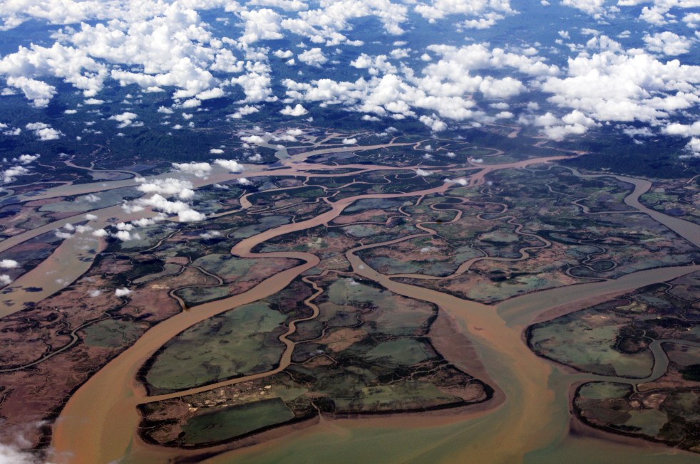
The Ganga Brahmaputra Delta, formed of rich sediment From: EO Snap.com
In 2007-08, the Ganges, Mekong, Irrawaddy and many other rivers flooded with more than 100,000 lives lost and more than a million displaced. Most of the deltas that were flooded did not receive a significant input of sediment. These major flood events lead to sediment trapping behind mega dams.
The direct impacts of delta subsidence and effective seas level rise include inundation of coastal areas, saltwater intrusion into coastal aquifers, increased rates of coastal erosion, an increased exposure to storm surges, in addition to the threats to food security, livelihood security, water security for millions and a huge loss of biodiversity. These threats impact hundreds of millions of people who inhabit the delta regions as well as the ecologically sensitive and important coastal wetland and mangrove forests.
Sundarban Forests constitute parts of Ganga-Brahmaputra Delta from: Wikimedia Commons
As Prof. James P Syvitski, the Chair of the International Geosphere-Biosphere Programme, told SANDRP, “We must learn to do better.” However, decisions surrounding dams in most regions of the world are not even assessing the impacts on deltas. Ignoring sediments when building and operating dams comes at a huge price. Someone else is paying that price right now and this price is steeply increasing. For full SANDRP report on this issue, write to us or see https://sandrp.in/Shrinking_and_sinking_delta_major_role_of_Dams_May_2014.pdf
This article provides a glimpse of the role that rivers play in sediment transport. It goes to show how little we know about the role played by rivers in our lives. We hope we have much richer debate around the role of rivers in our lives in days to come.
Rivers are not simply rivers, but they are our cultural life lines. Freshwater of rivers, fertile land on either side and island inside them, living beings, plants and vegetation and millions and millions of human beings, laughing and singing and shedding tears of sorrow, all taking together constitute the world of rivers. Men tried to fetter these rivers and construct dams, hydropower projects, riverfronts, embankments and barrages over them, encroached the floodplains, all in the name of progress. But the rivers want to break these fetters, as if they are giving a message to mankind to break the fetters of slavery, and to live a free and natural life. Whenever obstructions are put to them or they are polluted, they break their self restraint.
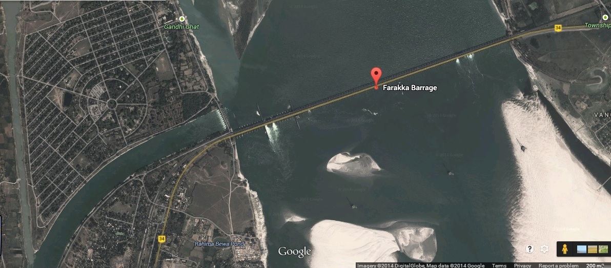
GOOGLE IMAGE OF FARAKKA BARRAGE
The 2245 m long Farakka Barrage is one of the most debated river management projects though for reasons which have nothing to do with either environmental or demographic reasons. Built primarily to serve the twin purpose of regulating the amount of Ganga water to flow out from the Indian territory into Bangladesh (East Pakistan then); and to ensure that sufficient water is diverted to Hooghly river to enable the regular flushing of silt at Calcutta port, the Farakka Barrage has been more often mired in controversy as India and Bangladesh have disagreed over the share of Ganga water between the two countries. While in the recent past, some efforts have been made to resolve this contentious dispute between the two nations, no thought has been spared so far on the long term impact the barrage has already caused and continues to do on an ongoing basis.
Though the Farakka Barrage was commissioned in 1975, work on the project had been going on for long. The structure of the Barrage was completed as early as in 1971 but the feeder canal which diverts water to the Bhagirathi river (as the Hooghly is called at this point) was completed only in 1975. By this time however, the cost of the project had escalated and when it was finally completed, the Farakka Barrage cost the nation Rs. 156.49 crore. The cruel irony is that since its commissioning, the Farakka Barrage has cost the nation much more but leave alone calculating the total cost, barring a handful, no one is even willing to concede the fact that the Barrage has caused irreversible harm to environment and society. The Barrage is being maintained by the Farakka Barrage Project (with 878 employees[1]), under Union Ministry of Water Resources, with jurisdiction upto 40 km upstream of the barrage, 80 km downstream along the right bank feeder canal and in the downstream area upto Jangipur barrage[2].
The Farakka Barrage was modelled on the lines of the Damodar Valley Corporation (DVC)- one of the first major riverine projects undertaken by the Central government under the influence of Nehruvian model. Both the DVC and the Bhakra project in the northern India were reflective of the government’s viewpoint that river management projects in India needed to be modelled on western lines – with its emphasis on large dams. In fact, plans for the DVC had already been drawn up by the British before independence during Lord Wavell’s tenure as Governor General. The entire project was modelled on the lines of the Tennessee Valley Authority of America and its chief engineer was actually appointed by the government of Independent India as the Chief Administrator of the DVC. When the DVC was planned and work on it was initiated in the late 1940s & early 1950s, the government was lavish on its claims regarding the benefits from the project. For eastern India, the DVC was considered to be a panacea to several problems in areas of power, irrigation and flood control. But as experience later showed, the claims had been falsely made on all fronts: the DVC in fact, made more areas in West Bengal prone to flood than before; the project’s utility in irrigation & power generation programmes was minimal.
Faulty Projections
By the late 1950s evidence was mounting that the projections made by the planners of the DVC had got it all wrong. The greatest demerit in the DVC was the sharp decline in the discharge capacity of Damodar river: from a level of 50,000 cusecs in 1954, the figure touched abysmal level of 20,000 cusecs. By 1959, the depth of Calcutta port had declined considerably after the construction of the Maithon and Panchet dams. The discharge capacity of several other rivers in the region like Jalonshi, Churni, Mayurakshi, Ajai and Roopnarayan also declined greatly and further contributed to the rising bed of the Hooghly. The situation slowly started reaching the point of no return and by the late 1950s, large ships stopped coming to Calcutta port and instead opted for Diamond Harbour.
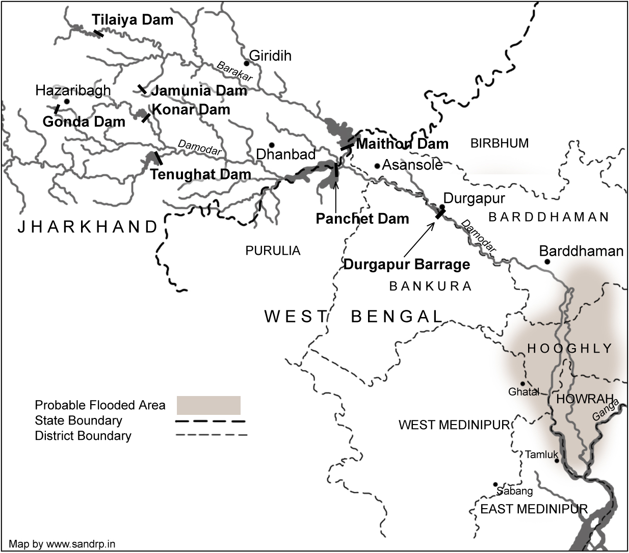
SANDRP MAP OF DAMODAR VALLEY DAMS
These facts were not hidden from the policy makers and planners when work on the Farakka Barrage was initiated. Yet, they chose to remain myopic and contended that the Barrage would flush out silt and mud from the Hooghly and thereby it would be possible to reclaim Calcutta port. What was ignored was the fact that till the DVC project had been initiated, the problem of Hooghly not getting desilted had never risen because of the nature and timing and force of the floods in the Damodar and Roopnarayan rivers. But, once various dams came up in the course of the DVC, these rivers lost their capacity to flush the Hooghly thereby jeopardising Calcutta port.
The Farraka Barrage was thus intended to correct a un-envisaged adverse impacts created by DVC dams. However, as events have proved, the step taken to correct a previous wrong move also turned out to be a faulty and unwise decision. However, it is not that words of caution were not available when the DVC dams or the Farakka Barrage were initially planned: they were only not heeded. To illustrate, Kapil Bhattacharya, an engineer in West Bengal contended that the amount of water that could be diverted from the Farakka Barrage into the Bhagirathi, would not be sufficient to flush the Hooghly to the level that Calcutta could once again be used as a port. He also suggested that the DVC should be modified in a manner so that water from river Roopnarayan flows into the Hooghly which would ensure regular flushing of the river. Regarding the Farakka Barrage, Bhattacharya further said that the project would reduce the water carrying capacity of the Hooghly and thereby make more areas in West Bengal prone to floods. He had further cautioned that there would be heavy silt accumulation even in river Padma on the Bangladesh side of the border and this would further make areas on the right bank of Padma flood prone.
Creating Problems at both Upstream and Downstream
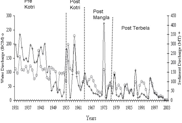
An alarming development has been the steady decline of the Ganga’s depth. In 1975, when the barrage was commissioned, the depth of the river at the barrage was 75 feet. In March 1997 when I visited the area with some friends, we were shocked to find that the depth of the river was only 13 feet. In effect, this means that the bed of Ganga had risen by 62 feet in the past years. Latest report shows that Ganga has become a havoc and the erosion goes on increasing year after year at Malda and Murshidabad districts.
Actually the Ganga river system transports vast amount of fluvial sediment. The Ganga used to be desalted up to 150 feet during flood season every year. On construction of Farakka barrage natural flushing of the sediment has been obstructed.
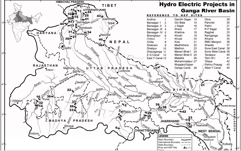
Ganga Basin Map (source: https://sandrp.in/basin_maps/)
This alarming development has led to untold misery to the people of Gangetic region of West Bangal, Bihar and Eastern UP as the level of the bed of all tributaries of Ganga has risen steadily. As a result, thousands of Chaurs (lowlands) that previously used to remain flooded only during the monsoons, now remain submerged under water for as long as ten months. The problem of constant water logging not only leads to possibilities of the outbreak of infectious diseases, but also causes unfathomed economic and social miseries on the people in these regions. Nature of the soil becomes alkaline and already lakhs of acres of once fertile land in Bihar have now turned totally barren. The fertility of the Gangetic plains today is a poor image of yesteryears.
While the problem of submergence as a result of the Farakka Barrage is acutely felt upstream of the barrage, the problem is one of erosion downstream of the barrage. As the water discharged into the Bhagirathi and the Padma is devoid of any silt, the water tends to cut into the land more sharply than in the past. As a result the problem of soil erosion is being very acutely felt in villages and towns on the banks of the Bhagirathi.
Depletion of Fish Resources
Besides water depletion, river diversion and dam projects also wreak havoc among the fish living in these waters. These projects adversely affect the fisheries which are migratory in nature. Dams and barrages act as barriers in their migratory paths and several species have either already become extinct or are facing extinction as they breed in a particular type of water while inhabiting in a different sort. The Farakka barrage has over the years acted as a barrier to the migration of marine & deltaic fish leading to the near absence of several popular varieties in the entire northern India. As the waters of several rivers of northern states directly or indirectly flow into the Ganga, there is a similarity in the type of fish found in the rivers. There are many aquatic verities (for instance prawn) that inhabit in fresh water but breed in marine water. Likewise, there are other species – like Hilsa – that inhabit in marine water, but have migrated upstream to breed. The Ganga once used to have plenty of Hilsa but this has changed as the fish is no longer able to breed leading to the near extinction of the Hilsa in the Ganga upstream of the Farakka Barrage.
In fact, it is not just a question of Hilsa alone, but there has been a substantial drop in the fish population on the entire Ganga. Prior to the barrage, during monsoon, there used to be a very high population of eggs and spawns in this stretch (UP and Bihar upstream of Farakka) of Ganga. After catering to the local needs (there is great demand for fish in Bihar and eastern UP) a substantial amount of eggs, prawns and different varieties of fishes used to be sent to other states. Today barely about 25 per cent of the local demand is met by the fish caught in this stretch and for the rest; the people have to depend on fish caught in other states.
It has been estimated that there has been an overall decline of 80 per cent in the entire population of fish upstream of the Farakka Barrage. Large fish, once found in abundance in the Ganga and its tributaries are no longer available and millions of traditional fishermen who have made their living for generations by catching fish now face destitution. What had previously been a close relationship between the fishermen and local customers have now been replaced by a cold system comprising air-conditioned trucks and ice-laden crates of fish brought in by large companies from other states like Andhra Pradesh. This not only makes the fish beyond the reach of the poor, but also alienates traditional fishermen from their ancestral profession in a situation where they do not have the training to do other jobs.
The Farakka Barrage has adversely affected the ecology and economy of Bangladesh too. Before 1975 Ganga used to flush out the Padma basin in Bangladesh and spread the alluvial soil in agricultural fields. But the barrage has disrupted this natural process. Now tides of the sea fill sand in the bed of Padma and also fields around it. Lakes and ponds are filled with saline water. The ground water level has fallen down resulting in drying up the shallow tube wells and dug wells. The Barrage has caused serious damage to land and populace both upstream and downstream of the barrage. Corrective measures are called for immediately and if not taken then there are portents of much greater havoc both to the people and to the land.
Chain of barrages will worsen the situation
The new plan of union government[3] to built chain of barrages along Ganga, every 50-100 KM will further worsen the situation. Natural process of silt transport and distribution in flood plains will be completely obstructed and breeding of migratory fishes will be further disturbed. The government should review this plan. A high level inter-disciplinary team need to be appointed to study at length the problems that have surfaced on account of the Farakka barrage and suggest measures that can be initiated to reverse the process of the damage. This plan will not succeed in either making Ganga Navigable or help the cause of rejuvenation of Ganga that the new government claims it is committed to. Strangely, the plan was announced without any details, public participation, environmental impact assessment, social impact assessment, public participation or participatory decision making. Free flow of Ganga is essential for rejuvenation of this holy river.
Ganga Mukti Andolan
Since 1982 fisher-folk and peasants of gangetic region are contending that rivering projects like dams, barrages and embankments are leading to economic downfall on account of fish depletion, submergence and fertile tracts turning alkaline. The Ganga Mukti Andolan has its origins in the resistance to the system of ‘Panidari’in Bihar. Under this system, waterlords and power contractors had fishing rights of Ganga and its tributaries. After a long struggle zamindari (Panidari) and contract system was abolished in January 1991 and traditional fisher people were given free fishing rights in 500 KM stretch of Ganga and in all rivers passing through the Bihar state. The movement continuously raised the issue of pollution caused by factories and thermal power station. Ganga Mukti Andolan has thus, moved from a movement of social and economic equity to one that questions the very model of development that is destroying the Ganga and those who depend on it. The movement wants a new direction for river management.
(Contact address of author: Anil Prakash, Jayaprabha Nagar, Majhaulia Road, Muzaffarpur – 842001, Bihar. Mobile – 09304549662, email – anilprakashganga@gmail.com)
END NOTES:
[1]Annual Report of Ministry of Water Resources, 2011-12
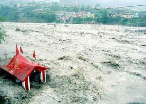
It is close to a year after the worst ever Himalayan flood disaster that Uttarakhand or possibly the entire Indian Himalayas experienced in June 2013[1]. While there is no doubt that the trigger for this disaster was the untimely and unseasonal rain, the way in which this rain translated into a massive disaster had a lot to do with how we have been treating the Himalayas in recent years and today. It’s a pity that we still do not have a comprehensive report of this biggest tragedy to tell us what happened during this period, who played what role and what lessons we can learn from this experience.
Floods in Uttarakhand Courtesy: Times of India
One of the relatively positive steps in the aftermath of the disaster came from the Supreme Court of India, when on Aug 13, 2013, a bench of the apex court directed Union Ministry of Environment and Forests (MoEF)[2] to set up a committee to investigate into the role of under-construction and completed hydropower projects. One would have expected our regulatory system to automatically initiate such investigations, which alas is not the case. Knowing this, some us wrote to MoEF on July 20, 2013[3], to exactly do such an investigation, but again MoEF played deaf and blind to such letters.
5 MW Motigad Project in Pithorgarh District destroyed by the floods. Photo: Emmanuel Theophilus, Himal Prakriti
The committee report, signed by 11 members[5], makes it clear that construction and operation of hydropower projects played a significant role in the disaster. The committee has made detailed recommendations, which includes recommendation to drop at least 23 hydropower projects, to change parameters of some others. The committee also recommended how the post disaster rehabilitation should happen, today we have no policy or regulation about it. While the Supreme Court of India is looking into the recommendations of the committee, the MoEF, instead of setting up a credible body to ensure timely and proper implementation of recommendations of the committee has asked the Court to appoint another committee on the flimsy ground that CWC-CEA have submitted a separate report advocating more hydropower projects! The functioning of the MoEF continues to strengthen the impression that it is working like a lobby for projects rather than an independent environmental regulator. We hope the apex court see through this.
Boulders devouring the Vishnuprayag Project. 26th June 2013 Photo: Matu jan Sangathan
Let us turn our attention to hydropower projects in Himalayas[6]. Indian Himalayas (Himachal Pradesh, Uttarakhand[7], Jammu & Kashmir, Sikkim, Arunachal Pradesh and rest of North East) already has operating large hydropower capacity of 17561 MW. This capacity has leaped by 68% in last decade, the growth rate of National Hydro capacity was much lower at 40%. If you look at Central Electricity Authority’s (CEA is Government of India’s premier technical organisation in power sector) list of under construction hydropower projects in India, you will find that 90% of projects and 95% of under construction capacity is from the Himalayan region. Already 14210 MW hydropower capacity is under construction. In fact CEA has now planned to add unbelievable 65000 MW capacity in 10 years (2017 to 2027) between 13th and 14th Five Year Plans.
Meanwhile, the Expert Appraisal Committee of Union Ministry of Environment and Forests on River Valley Projects has been clearing projects at a break-neck speed with almost zero rejection rate. Between April 2007 and Dec 2013[8], this committee recommended final environment clearance to 18030.5 MW capacity, most of which has not entered the implementation stage. Moreover, this committee has recommended 1st stage Environment clearance (what is technically called Terms of Reference Clearance) for a capacity of unimaginable 57702 MW in the same period. This is indicative of the onslaught of hydropower projects which we are likely to see in the coming years. Here again an overwhelming majority of these cleared projects are in Himalayan region.
Agitation Against Lower Subansiri Dam in Assam Source: SANDRP
What does all this mean for the Himalayas, the people, the rivers, the forests, the biodiversity rich area? We have not even fully studied the biodiversity of the area. The Himalayas is also very landslide prone, flood prone, geologically fragile and seismically active area. It is also the water tower of much of India (& Asia). We could be putting that water security also at risk, increasing the flood risks for the plains. The Uttarakhand disaster and changing climate have added new unknowns to this equation.
We all know how poor are our project-specific and river basin-wise cumulative social and environmental impact assessments. We know how compromised and flawed our appraisals and regulations are. We know how non-existent is our compliance system. The increasing judicial interventions are indicators of these failures. But court orders cannot replace institutions or make our governance more democratic or accountable. The polity needs to fundamentally change, and we are still far away from that change.
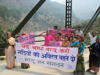
Peoples protests against Large dams on Ganga. Photo: Matu Jansangathan
The government that is likely to take over post 2014 parliamentary elections has an opportunity to start afresh, but available indicators do not provide such hope. While UPA’s failure is visible in what happened before, during and after the Uttarakhand disaster, the main political opposition that is predicted to take over has not shown any different approach. In fact NDA’s prime ministerial candidate has said that North East India is the heaven for hydropower development. He seems to have no idea about the brewing anger over such projects in Assam and other North Eastern states. That anger is manifest most clearly in the fact that India’s largest capacity under-construction hydropower project, namely the 2000 MW Lower Subansiri HEP has remained stalled for the last 29 months after spending over Rs 5000 crores. The NDA’s PM candidate also has Inter Linking of Rivers (ILR) on agenda. Perhaps we have forgotten as to why the NDA lost the 2004 Parliamentary elections. The arrogant and mindless pursuit of projects like ILR and launching of 50 000 MW hydropower campaign by the then NDA government had played a role in sowing the seeds of people’s anger with that government.
In this context we also need to understand what benefits these hydropower projects are actually providing, as against what the promises and propaganda are telling us. In fact our analysis shows that the benefits are far below the claims and impacts and costs are far higher than the projections. The disaster shows that hydropower projects are also at huge risk in these regions. Due to the June 2013 flood disaster large no of hydropower projects were damaged and generation from the large hydro projects alone dropped by 3730 million units. In monetary terms this would mean just the generation loss at Rs 1119 crores assuming conservative tariff of Rs 3 per unit. The loss in subsequent year and from small hydro would be additional.
It is nobody’s case that no hydropower projects be built in Himalayas or that no roads, townships, tourism and other infrastructure be built in the Himalayan states. But we need to study the impact of these massive interventions (along with all other available options in a participatory way) in what is already a hugely vulnerable area, made worse by what we have done so far in these regions and what climate change is threatening to unleash. In such a situation, such onslaught of hydropower projects on Himalayas is likely to be an invitation to even greater disasters across the Himalayas. Himalayas cannot sustain this onslaught.
It is in this context, that the ongoing Supreme Court case on Uttarakhand provides a glimmer of hope. It is not just hydropower projects or other infrastructure projects in Uttarakhand, or for that matter in other Himalayan states that will need to take guidance from the outcome of this case, but it could provide guidance for all kinds of interventions all across Indian Himalayas. Our Himalayan neighbors can also learn from this process. Let us end on that hopeful note here!
National Democratic Alliance (NDA) led by BJP’s Mr. Narendra Modi has been given a mandate to govern India for the next five years. Without going into the political and social facets related to this issue, there are a number of justifiable concerns about this government’s stand on critical issues of water and environment.
While the importance of water and environment sectors for the people, their livelihoods, society and economy is acknowledged, how crucial these sectors are for them is not easily appreciated. For example, environment is important not only for tigers and trees, but also for livelihoods of hundreds of millions of Indians who depend on natural resources. More than 60-65% Indians continue to depend on agriculture and every farm can benefit from better water resource management.
Some of the major challenges plaguing the water and environment sectors in India include: urgent need for an inclusive, democratic and accountable governance, holistic assessment of impacts the very many interventions in the Himalayas (lessons from Uttarakhand flood disaster of June 2013[1]), ecological restoration of Ganga and other rivers, dealing with climate change in a way that protects lives and livelihoods of the vulnerable sections, etc., to name a few.
The leaders of the party forming the new government have already declared their agenda in terms of completion of Sardar Sarovar Project (SSP) on Narmada, pushing interlinking of rivers (ILR), pushing for more dams in the name of irrigation, pushing big hydropower projects in North East India (Mr Modi had said in his campaign that NE is heaven for hydropower projects) and mega industrial initiatives like the Delhi Mumbai Investment Corridor.
This agenda indicates that the importance of water and environment to the vast millions is not understood. Nor is the significance of the challenges to this sector appreciated. Pushing the above agenda is not only fraught with serious risks in terms of social, environmental, economic and interstate issues, but these projects are not likely to deliver the promise of this party at the elections: Better life, more jobs, more development, fulfillment of basic needs of the people who do not have access to these at the moment. Pushing this agenda is not likely to deliver stated promises, however blind push for more and bigger projects will compound strife and conflicts.
Let us look at the issues related to the NDA Agenda. These are not incidental issues, but issues inherent to the nature of these centralized, mega projects themselves.
Does ILR have scientific basis? The basic premise of ILR is that certain basins are water surplus and others are water deficit. It is assumed that occurrence of floods in a basin means there is surplus water in the basin and occurrence of drought or water scarcity in other basin means it is water deficit. This premise itself is not scientifically, ecologically and socially robust.
While this is said, there is no attempt at assessing and exhausting the available water options in any basin in India. Twithout this exercise, there can be no scientific basis for declaring a basin surplus or deficit. The ILR advocates seem to ignore the reality that India’s water lifeline is groundwater and the best way to sustain groundwater is through local water systems and recharge. They also seem to ignore the massive social, environmental impacts and constitutional issues. ILR is basically a collection of large number of major irrigation projects (over 84), but proponents of ILR do not seem to realize that in last two decades, there has been no addition to net irrigated area by these projects, in spite of addition of thousands of new projects.[2]
“Sabarmati Model” holds no water for Ganga or other rivers During the elections in Varanasi constituency that elected Mr Modi, the issue of cleaning of Ganga remained prominent. BJP claimed that they will clean up Ganga at Varanasi the way they cleaned up Sabarmati River that flows through Ahmedabad in Gujarat. The trouble with this claim is that Sabarmati has not been cleaned up at all. The water flowing through Sabarmati as it flows through the city of Ahmedabad is actually the water of Narmada River, diverted into Sabarmati. Ahmedabad has no right over this water which was supposed to be meant for Kutch, Saurashtra and North Gujarat. If you go upstream along Sabarmati River from the point where Narmada Main Canal releases water in Sabarmati, you will see the reality of dry Sabarmati River. And if you go down to the Vasna barrage, downstream of Ahmedabad along the Sabarmati, you will see the state of polluted Sabarmati River. This model clearly holds no water either for Ganga or any other river.
River Ministry? There is speculation in media[3] that the new NDA government is going to create a new River Ministry at the centre. The same media report also stated that this ministry will push Inter Linking of Rivers (ILR)! This seems like a proposal for Ministry of River Destruction, since ILR is a recipe for destruction of rivers. If at all the new government is interested in an act of goodwill towards rivers, it needs to start with understanding what is a river and what are its various functions along the various stretches during various periods, including the social, ecological, economic, hydrological, geo morphological, biodiversity related, groundwater related and most importantly, livelihoods related functions. This exercise will mean understanding the roles of various arms of the government which affect the river. Some key ministries which affect river profoundly include: Ministry of Water Resources, Ministry of Environment and Forests, Ministry of Power, Ministry of Urban Affairs, Ministry of Rural Development, Ministry of Home Affairs (Disaster Management), Ministry of Agriculture, Department of North East Region, Ministry of Non Conventional Sources of Energy, to name only a few. How is this new proposed Ministry of River Going to coordinate with these ministries? Moreover, according to India’s constitution, Rivers are essentially state subjects and no state is likely to welcome such infringement of centre into what the states see as their domain of responsibility.
Ganga a National Project? There are statements from Mr Amit Shah[4], that the new government will give National status to the Ganga Project. It is not clear what is meant by this. Ganga is already under the Prime-Minister headed National Ganga River Basin Authority, but the Authority, five years after its constitution, has failed to change a single attribute affecting the Ganga. Similarly, Ganga River Basin Management Plan that IIT consortium is working on is already known to be pathetic in its understanding of the river, while pushing for privatization. We do not need another project in the name of Ganga, national or local. If the aim of declaring Ganga as a National Project is to wrest its control from the state, as the media suggests, then it is going to raise a lot of hackles.
What we need is a new approach to river governance, which is based on ecological, and not engineering principles, which is participatory, and not exclusive and which is democratic and not autocratic.
Himalayas & Hydro-onslaught Irrefutable evidence shows that building large number of major hydropower projects in Himalayas is having unprecedented impacts, some are known, many are unknown. The flawed environmental governance around these projects is well known in terms of dishonest EIAs, flawed and compromised appraisals, ineffective (these are consultations just in the namesake, in reality there is no basis for informed participation) public hearing and non-existent compliance, both at project and cumulative level. One implication of this was felt in terms of the role of such projects in the Uttarakhand flood disaster of June 2013, after which, no political leader from any party spoke about this. It was left to the Supreme Court to order and enquiry into this. The report of this investigation clearly indicates the role of hydropower projects in increasing the proportions of the disaster, and more work on this issue remains to be done. In North East itself, India’s biggest mass based public agitation against dams & hydropower projects has been going on. The anger of people has led to stoppage of the work on 2000 MW Lower Subansiri Hydropower project (largest capacity hydropower project under implementation in India) for 30 months now, after over Rs 5000 crores were irresponsibly spent by NHPC without completing even basic studies. Mindless pushing of more such projects in the region is clearly not a prudent move.
Source: MATU Jansangathan
BJP manifesto’s promise of expeditious and single window environment clearances is clearly dangerous in this context. What India needs is stronger and not weaker environmental governance. The advocacy[5] to “reduce time and transaction costs for the industry” under the circumstances seems inappropriate particularly from an organisation which was possibly the only environmental organisation represented on the completely flawed EIA registration process at Quality Council of India. The QCI process failed to achieve any improvement in the quality of EIA in almost 4 years of its existence
Sardar Sarovar Dam The new government wants to take the SSP Dam from its current height of 121.92 m to its final design height of 138.68 m. Firstly, there are serious doubts if this height increase is required since it can be shown that Gujarat and Rajasthan can get their share of water from Narmada without this increase in height. Secondly, Gujarat is not even in a position to use more than 20% of the water it already gets from the river at current height of the dam for the purposes for which the project was designed: providing water for the drought affected regions in Kutch, Saurashtra & North Gujarat. On the other hand, urban centres, industrials areas, SEZs, cosmetic river beautification schemes have appropriated a large chunk of SSP waters without legal, democratic sanction or justification. Gujarat really does not have a case for increasing the height of SSP Dam.
Moreover, this will also entail such massive additional submergence, displacement and disruption of lives of tribals and farmers that it is sure to create huge opposition. The just rehabilitation of already affected people is far from complete, in fact, most of the affected population has not been given minimum 2 ha of land required under the Narmada Tribunal award and subsequent accepted policies.
Mr Modi during his tenure of 13 years as Chief Minister of Gujarat failed to complete the canal network of SSP in the drought prone areas in whose name the project has always been justified. It needs to be noted that the agitation against SSP did not stop Gujarat government from going ahead with construction of canal network. It was not for lack of finances that SSP could not complete the canal network. SSP has been getting largest quantum of money from the Government of India’s Accelerated Irrigation Benefits Programme ever since the AIBP scheme started in 1996. This support to SSP from AIBP was clearly wrong since SSP was never the last mile project for which AIBP was meant, but the big dam lobby in Union Water Resources ministry and Gujarat government were hand in glove in this misallocation of AIBP money for SSP. In fact, Mr Modi arm-twisted the Planning Commission in 2011-12 to sanction the escalated costs for SSP even when the issues raised by Planning Commission officers remained unanswered.
Unused Narmada Canal waters flow into Salt pans, not only at a huge cost, but also affecting livelihoods of salt pan workers and the ecology Photo: Counterview
It is the ineptitude of Gujarat Government under Mr Modi that is on show in why it could not complete the canal network on drought prone areas in Gujarat. Mr Modi would do well to remember the reasons for that failure before he considers the mega projects agenda as Prime Minister.
Moreover, on SSP, the issues of completing repairs of the damages the Sardar Sarovar dam structure suffered four years ago & related issue of safety of the dam are yet to be resolved[6] and Gujarat has embarked on building another Garudeshwar Dam in immediate downstream without any impact assessments, participatory democratic process or required sanctions[7]. The legality of the Garudeshwar Dam work stands challenged in the National Green Tribunal by the affected tribals.
MAJOR RISKS FOR NEW GOVERNMENT Some major risks for the new government include: the track record of Gujarat government that Mr Modi headed for the last 13 years; no checks from coalition of parties; poor image, strength, morale and track record of Congress as the chief opposition party; large sections of almost completely subservient media[8] and BJP’s problematic manifesto[9].
Why UPA faced people’s anger The new government also needs to remember why the outgoing ruling coalition of UPA (United Progressive Alliance) lost so badly in spite of some unprecedentedly remarkable, and pro people steps taken by it. Absence of accountable and participatory governance (which also manifested in terms numerous scams) was one of the major reasons as to why there was huge anger in people’s mind about the UPA regime. Another aspect of corruption and high-handedness was apparent in the scandalous way UPA dealt with governance of environmental issues: blatantly changing its environment ministers from bad to worse.
Even if we leave aside the Rajas and Balus of UPA I, the UPA II began on a positive note with appointment of Mr Jairam Ramesh as environment minister. While we had our share of criticism of functioning of Mr Ramesh as environment minister[10], he was possibly the best environment minister India have had.
But under pressure from misguided and misinformed corporate vested interests, Mr Ramesh was removed (kicked upstairs) and Mrs Jayanthi Natarajan was brought in. She did not really help the cause of environment as is apparent, for example, from her answers to the two debates on Ganga river in Parliament (these debates were unprecedented in their own right) as also sanctioning projects rejected by statutory bodies like Forest Advisory Committee.
Strangely, she too was removed to bring in disastrously, Mr Veerappa Moily[11], who also held the Oil and Petroleum ministry. Mr Moily then went about the designated task of green lighting everything, not bothering about governance issues, people’s concerns or environmental consequences. This led to massive anger anger against Moily as well as UPA.[12]
Such arrogant handling of governance of environmental issues that affect the lives and livelihoods of millions of most vulnerable sections of people was bound to be punished[13]. This is clearly another reason behind the anger of people that UPA government faced in the elections.
Playing favorites UPA is also guilty of playing favorites when it came to appointing non governmental persons in environmental decision making. In almost every committee on environmental decision making, including Prime Ministers’ Council on Climate Change, National Tiger Task Force, Coastal Zone Management Committee, National Ganga Authority, Inter Ministerial Group on Ganga, Western Ghats Task Force, QCI process on registration of EIA consultants, 12th Plan working Groups to name only a few, everywhere one could find representatives of only particular organisation. Leaving aside the issue of effectiveness of the role played by representatives from this organisation, such tendencies of playing favorites is bound to raise serious questions. While many people at grassroots may not be aware of this inappropriate action by UPA government, the resultant outcomes of these committee invited various reactions ranging from disbelief, anger and even an uproar, as it happened in case of Kasturirangan Committee on Western Ghats.
While the result of anger of the voters could be seen in decimation of the UPA in the elections, the new NDA government will also do well to remember that even the Vajpayee government was voted out in 2004 for similar reasons. The mindless pursuit of agenda of inter linking of rivers and 50000 MW Hydropower initiatives, disregarding all the concerns and protests of the people across the country, along with the rejection of India Shining campaign were some of the causes for the voting out of the previous NDA regime in 2004.
SOME SPECIFIC TASKS In what follows we have given several examples of specific tasks before the new government. This is not an exhaustive, but only an indicative list.
Ganga Action Plan, Rivers Action Plans, NGBRA, CPCB, SPCBs Mr Modi has said that he would like to give priority to cleaning of Ganga River. Any such effort has any chance of success only if there is an attempt at understanding why our efforts at river pollution for the last 40 years have shown no impact:
Þ Water Pollution Control Act, 1974 The Water Pollution Control Act led to setting up a huge and powerful bureaucracy including Central and state pollution control boards. 40 years after setting up of this whole institutional and legal infrastructure, we do not have a single that this establishment can claim to have cleaned up.
Þ Ganga Action Plan, 1986 This plan was launched with much fanfare by the then Prime Minister Rajiv Gandhi, but without trying to understand why the water pollution bureaucracy failed.
Þ National River Conservation Authority 1994 This authority, the only institution in the name or river conservation in India, had Prime Minister of India, no less, its chairman. In ten years of UPA, the Prime Minister of India did not get time for a single meeting of this authority.
Þ GAP II 2000 The second phase of GAP was launched, again without making any honest attempt at understanding the failure of GAP I.
Þ NGBRA 2009 In Feb 2009, just before the last parliamentary elections, National Ganga River Basin Authority, again under Prime Minister. As noted earlier, this too has failed to make any impact on the state of Ganga.
What all this shows is that we have tried many things, including legal, institutional, financial, and authoritative, with Prime Minister at the helm, but have achieved no success. This is also true of the previous NDA regime during 1998-2006. If we do not make an honest attempt at understanding the reasons for these failures, there is little hope for success in future. The efforts at river cleaning has not suffered due to lack of money (over Rs 20 000 crores have been spent on Ganga alone, as per one estimate), for lack of institutions, for lack of political attention, for lack of media attention, for lack of judicial attention, for lack of infrastructure [where infrastructure exists (e.g. Delhi with the highest Sewage Treatment Capacity], there too there is no change in state of river), or technology. One major reason for the failure was the complete disconnect between the people whose lives depend on the river and those who took the decisions or managed the system. In other words, unless you make the river governance more democratic, there is no hope for Ganga or other rivers.
Some basic steps to make governance of rivers democratic could include: Setting up of management committee (with 50% independent members from outside the government) for management of each Sewage Treatment Plant, each freshwater treatment plant, each tributary, each 10 km stretch of river, each water utility, each city (& sub city level where cities have population above 1 lakh). These committees should be legally empowered and the officials should be made responsible to these committees.
Jayanthi Tax In this regard, it would be useful to remember that during the election campaign, Mr Modi had accused Mrs Jayanthi Natarajan for collecting Jayanthi Tax as environment Minister, allegedly for collecting bribes for environment clearances. This was a very serious charge Mr Modi had leveled. Now that he heads the new government at centre, he must institute a credible enquiry into this charge to prove that he was not making just frivolous statements.
Maharashtra Irrigation Scam One state that has given NDA the highest number of seats after Uttar Pradesh is Maharashtra, the NDA coalition got 42 of 48 seats in this state. One of the major reasons for this debacle of UPA was that the UPA here got a very corrupt image, in spite of its Chief Minister having a relatively clean image. This was largely due to the massive Rs 70 000 crores irrigation scam in that state. The NDA partners in Maharashtra also played a role in exposing this corruption, although the top brass of NDA was also allegedly involved in the scandal. To this corrupt image was added the arrogance shown, for example, by deputy Chief Minister (who resigned on charges of corruption, but came back even without any investigation into the charges) when he first asked how are people expecting him to give water from dams – by urinating in the dams? During elections he actually threatened a village that water will be cut off if they do not vote for his party! This combination of corruption and arrogance was sufficient to enrage the voters.
Here again one expects the NDA government at centre to take decisive credible action in exposing the guilty in Maharashtra irrigation scam and brining to book those who are responsible both among the politicians and bureaucrats-engineers. Here, as BJP spokespersons in Maharashtra have been saying, the Madhav Chitale committee has basically done white washing role[14] and hence we need an independent investigation. We hope NDA government at centre will take this up urgently.
Andhra Pradesh Irrigation Scam Similar action is also required in Andhra Pradesh Irrigation scam exposed by the CAG report[15].
AIBP As noted above, the Accelerated Irrigation Benefits Program has majorly failed in achieving any additional net irrigation area by major projects at national level. The CAG has noted in more than one report the failure of AIBP and so has the Planning Commission. The new NDA government could start with instituting a credible independent enquiry into the reasons for failure of this scheme.
Uttarakhand Disaster and role of hydropower projects[16] Following the worst ever disaster faced by the state of Uttarakhand in June 2013, the role played by indiscriminate construction of hydropower projects and other infrastructure needed to be investigated since prime facie they had played significant role in increasing the proportions of disaster. The UPA government did nothing, and it was left to the Supreme Court to ask MoEF to set up an Expert Body for this. In the meantime, SC ordered stay on any more projects. The MoEF along with Central Water Commission and Central Electricity Authority and the Congress’s Uttarakhand state government, have been trying to push more projects in stead of honoring the Apex Court orders. In April 2014, the report of Expert Body lead by Dr Ravi Chopra has been submitted. The new Union government, it is hoped, will take credible steps to implement the recommendations of the Expert Body at the earliest date.
Independent National Environment Monitor It is well known that MoEF as an independent environmental regulator is seriously compromised with shoddy EIAs, flawed appraisal and non existent compliance. This situation has remained unchanged for the last decade and more. The Supreme Court of India, seeing this, had in 2011 ordered that an Independent Environment Regulator needs to be set up at National and state level. The outgoing central government had shown reluctance to do anything in this regard, in spite of repeated Supreme Court orders. The new government has a historical opportunity to indeed set up a truly independent & accountable environment regulator, at the same time increasing the transparency and participation of people in the environmental governance through fresh round of democratic reforms.
Cabinet Committee on Investment One of the flawed legacy of the previous UPA government is the Cabinet Committee on Investment, which has been created to bypass the statutory work of the MoEF. The new Union government would do well to disband this extra legal committee.
Polavaram Project Authority Even as elections were underway, in a most inappropriate decision, the outgoing government set up a Polvaram Project Authority, without even consulting affected states of Orissa and Chhattisgarh. In both these states there is either BJP government or BJP led government. There are also cases going on against this project, including civil suits filed by the governments of Chhattisgarh and Orissa. In the interest of these states and affected tribals, the new Union Government should scrap the Polavaram Project Authority.
Mullaperiyar The 119 year old Mullaperiyar dam has already suffered damages in the past and there is no doubt that it has limited life. To overcome the inflexible attitude of Tamil Nadu and respecting the constitutional duty of Kerala government to protect the life and property of people of Kerala, it become the duty of the Union government to initiate process for new a arrangement (e.g. lower the intake level to 50 ft from current 106 ft, as seen promising both by the Empowered Body and Supreme Court in May 2014) and decommissioning of the dam in a time bound manner. The previous Union government completely failed in this and the new government has an opportunity to correct this.
Central Water Commission Central Water Commission is India’s premier technical body on water resources. Water resources development and management has always remained crucial to any country’s water, food, livelihood and environment security. However, for this we need a really independent and credible technical body at the top, on the lines of United States Geological Survey (USGS). USGS, is known to be source of very reliable water resources data world over. However, USGS’s main task is to gather data and put it in public domain. Use of that data for development tasks and such other functions are not the mandate of USGS, there are other bodies for that. Unfortunately in India, CWC tasked with data gathering, sanctioning projects, monitoring and so many other contradictory functions. Moreover, CWC is working more like a big dam lobby, and even the assessment of hydrological data, flood forecasting functioning, water use data and projections, climate change implications, dam safety issues, etc are all getting colored by the lobbying tendency of those who head CWC. This is having a very deleterious effect on the water resources development and management in India.
It is high time that there are reforms in CWC to separate its various contradictory functions and make its functioning transparent, accountable and participatory. The new Union government has a chance to initiate such reforms in CWC and Ministry of Water Resources.
Technical Advisory Committee of CWC The TAC of CWC is a very little known, but powerful body. It sanctions projects worth thousands of crores every year, but its functioning is completely non transparent, unaccountable and it has no independent members. Since the new government has been raising the issue of corruption by UPA during the election campaign, it is hoped that the new government will work to fight corruption and one of the key steps it can do is to make the functioning of TAC transparent, accountable and ensure that at least 50% members of the TAC are non governmental, independent people with track record of having shown independent mind.
Urban Water Sector The social, environmental, economic and carbon footprint of this sector increasing at huge pace, without any success story in sight. The big cities are find it easy to promote construction of big dams rather than go for rain water harvesting, sewage water treatment & recycle, demand side measurement, groundwater recharge, reduction in losses and such other measures. SANDRP report on unjustified dams being pushed in Mumbai highlights this issue. The 12th Plan Working Group report on Urban water issues have several useful recommendations that has remained unimplemented. These need to be urgently implemented.
Climate Change Climate change in the biggest threat that vulnerable sections of Indian people face, as do the vulnerable sections of the rest of the world. This is not only relevant for water and environment sectors that we are discussing here, but for all sectors. As Environmental Groups in Gujarat have noted[17], people of Gujarat do not have good experience of the Modi regime in the state. The record of the 10 year long UPA government is very poor on this issue. We hope the new Union government will do better and begin with identification of the sections of the people who are vulnerable and start working on action plan to address the concerns of such sections, while also reducing the carbon footprint of India through reduction in consumption patterns of richer sections.
Suggestions for positive actions As analysed by Dr. Ashok Gulati (former chairman of Commission for Agricultural Costs and Prices) and Dr. Tushar Shah (International Water Management Institute) separately, the relatively high agricultural growth in Gujarat in first decade of current millennium was largely due to local water harvesting work that happened in Gujarat through check dams, groundwater recharge etc, largely in non governmental sector. The new government at centre can bring about changes in policies and programs to learn lessons from such success stories to achieve such results all over India.
Similarly on the issue or river rejuvenation, management and conservation front as also environmental management front, a decentralized bottom up community driven approach can be taken up.
It can encourage people led, scientific and ecological river restoration work.
Promote System of Rice Intensification in a major way, it can not only reduce water use, fertiliser use, use of other chemicals, reduce seed requirement, increase farmers’ income, reduce agriculture sector’s carbon footprint and thus help mitigate and also adaptation to changing climate. This is possible in other crops too, as has been demonstrated at farmer level.
Encourage measures that can help increase carbon content of the soil, this will also have multiple benefits to farmers, economy and environment.
It can strengthen implementation of Forest Rights Act which UPA, despite introducing it, failed to do.
It can protect free flowing rivers for their social, ecological, cultural values.
It can also engage more effectively with civil society and community groups in a credible manner.
A recent SANDRP study “Shrinking and Sinking Deltas: Role of Large Dams” has shown that large dams are playing big role in sinking of deltas in India. This is not even properly studied. The new government can initiate a scientific study in this regard and ensure that before taking up any new project, this aspect is studied.
Conclusion I started writing this brief note following questions from several media friends, but it has become much longer! So let us come to the conclusion. I am not even sure if the new government is in any mood to listen to such unsolicited suggestions, but let us put it out and hope for the best! I decided to put this out, even as Mr Modi prepares to take office on May 26.
This article tries to show the risks, challenges and some immediate tasks of the new government at the centre. In sum, the new NDA government would do well not to forget the reasons for rejection of NDA in 2004 and UPA now in 2014. Both were guilty of bull dozing ahead with their agendas without listening to the people. Avoiding that may be the biggest challenge this government faces, besides the specific ones mentioned above.
[13] For example, Dakshin Kannada and Mangalore saw a huge socio-political movement against Moily and Congress due to his politically motivated support to Yettinahole Diversion Project.
“We enjoy Pushing Rivers Around” –An early Hydraulic engineer in California (from Patrick McCully’s Silenced Rivers, 1996)
“We can tame the mighty rivers. We are an example of human will and endeavor”
-Sutlej Jal Viduyt Nigam Limited, damming the entire Satluj Basin in India.
“A river flowing to the sea is a waste”- a view held by several water resource developers in India
Welcome to Anthropocene [1],says James Syvitski, a leading oceanographer, geologist and hydrologist from Colorado University who has been studying subsidence of deltas.
Some scientists are now placing Anthropocene, an era marked with human interference with natural systems, at par with geological epochs like Pleistocene and Holocene. It is manifested in many ways. Rivers and associated systems like deltas and floodplains possibly have had to face the maximum brunt of the Anthropocene.
Cutting edge scientists like Prof. Syvitski who study the changes in our deltaic systems seem to reach to a common conclusion: Delta subsidence is now the main driving force for effective sea level rise for many coastal environments. This subsidence is more influential than sea level rise related to global warming and any deltas are sinking much faster than the sea level is rising.
But why are deltas sinking? What is the main reason behind this subsidence which is eating away land and making millions of people more vulnerable?
It has been established that the main reason behind delta subsidence is drastically reducing sediments reaching the delta.Studies estimate that during the past century, there has been a 94% reduction in Krishna’s sediment reaching the delta, 95% reduction from historic load in Narmada, 80% reduction in Indus, 80% reduction in Cauvery, 96% reduction in Sabarmati, 74% reduction in Mahanadi, 74% reduction in Godavari, 50% reduction Brahmani, etc.[2],[3]
But why are sediments not reaching the delta?
Almost unanimous agreement between scientists indicates that the reason behind this drastic decline in sediments is sediment retention by dams and reservoirs in the upstream[4].(Walling and Fang (2003), Vörösmarty et al., 2003; Syvitski et al.,(2005), Erisson et al, (2005), Walling (2008), K Rao et al (2010), H Gupta et al (2012) ). This has been reiterated in IPCC WG II Report, April 2014.[5]
Bhola Island in Bangladesh, eroded by Meghana River. PhotoSrestha Banerjee, Green Clearance Watch
Prof. Syvitski wrote a few words on the issue for SANDRP. He says, “A delta can form only where the sediment volume supplied from a river can overwhelm the local ocean energy (waves, tides, currents). Ocean energy is ceaseless. Engineering of our river systems, largely through the construction of upstream dams and barrages, has reduced this sediment supply. Consequently ocean energy has begun to reduce the size of our deltas, and coastal retreat is presently widespread. Deltas, once the cradle of modern civilizations, are now under threat — some deltas are in peril of lasting only the next 100 years. Sea level is rising due to ocean warming and glacier melting. Incessant mining of groundwater from below a delta’s surface, along with oil and gas extraction, further contribute to our disappearing deltas. At risk are the residences of more than 500 million people, the loss of biodiversity hotspots, major infrastructure (e.g. megacities, ports), and the rice and protein bowls of the world. Every year thousands of people drown due to storm surges and other coastal flooding. Sinking deltas are evidence of the magnitude of the human footprint on our planetary environment. We must learn to do better.” Professor J P Syvitski (U Colorado, Boulder, USA), Chair — International Geosphere-Biosphere Programme (ICSU), Executive Director, the Community Surface Dynamics Modeling System
Large reservoirs trap as much as 80% of the upstream silt. As a result, most rivers are carrying much less sediment, and some rivers (like Krishna, Indus, Nile, and Colorado) transport virtually no sediment! In the last 50 years, the combined annual sediment flux of the large Chinese rivers has been reduced from 1800 million tons (Mt) to about 370 Mt[6]mainly due to frenzied dam building. The impact of dams and reservoirs on sediment retention has been so significant that the resultant reduced sediment load represents a volume of about 730 km3, equivalent to an area of 7300 km2 assuming a 10 m thick bed[7]. Waling (2008) states that about 25 Gt/year of sediment are trapped by large dams each year. IPCC Report (Assessment Report 5, 2014) refers that 34 rivers with drainage basins of 19 million km2 in total show a 75% reduction in sediment discharge over the past 50 years due to reservoir trapping.
Delta Subsidence and Effective Sea Level Rise (ESLR)
While this delta subsidence and sediment retention has several impacts on dense delta population and coastal ecosystems which offer important services, one of the most serious impacts is its direct role in Effective Sea Level Rise. Ericsson and Vorosmarty et al, 2012[8], concluded that decreased accretion of fluvial sediment resulting from sediment retention and consumptive losses of runoff from irrigation (also due to dams) are the primary determinants of ESLR in nearly 70% of studied deltas.
More and more scientists are concluding that climate related sea level rise has a ‘relatively minor influence on delta conditions’, as compared to anthropogenic reasons. As seen above, there is an almost unanimous agreement that dams are the most important factor influencing contemporary land-ocean sediment fluxes.[9] Globally, greater than 50% of basin-scale sediment flux in regulated basins is potentially trapped in artificial impoundments of approximately 45,000 reservoirs (with dams 15 m high) (Vörösmarty et al., 2003; Syvitski etal., 2005) and sediment delivery to deltas has been reduced or eliminated at all scales.[10]Other reasons for delta subsidence include flow diversion by dams, sediment compaction due to groundwater abstraction, oil and gas exploration and mining, etc,.[11]
Deltas, formed by centuries of accretion of rich sediment, are one of the most fertile and densest populated regions across the world. It is estimated that close to half a billion people live on or near deltas, often in megacities.[12] Although constituting a mere 5% of the total landmass, coastal regions sustain almost three-quarters of the world’s population and yield more than half of global gross domestic product (Vorosmarty et al.,2009).
The direct impacts of ESLR and delta subsidence include inundation of coastal areas, saltwater intrusion into coastal aquifers, increased rates of coastal erosion, an increased exposure to storm surges, etc. These threats have implications for hundreds of millions of people who inhabit the deltaic as well as the ecologically sensitive and important coastal wetland and mangrove forests.
Already, some studies are ringing alarm bells. It is estimated that if no mitigation measures are undertaken and sediment retention continues, then by 2050, more than 8.7 million people and 28,000 km2 of deltaic area in 33 deltas studied including Ganga-Brahmaputra, Indus, Krishna and Godavari could suffer from enhanced inundation and increased coastal erosion. In addition, a larger population and area will be affected due to increased flood risk due to storm surges[13]. Conservative estimates state that delta area vulnerable to flooding could increase by 50% under the current projected values for sea-level rise in the 21st century and this could increase if the capture of sediment upstream persists and continues to prevent the growth of the deltas.[14]
The Intergovernmental Panel on Climate Change (IPCC) projects that sea level will rise by another 21 to 71 cm by 2070, with a best estimate of 44 cm averaged globally. This will further compound impacts of delta subsidence and sediment trapping.
It has been estimated that even in the case of debilitating floods, sediment has not reached rivers in the deltas.[15]In 2007–08 alone Ganges, Mekong, Irrawaddy, Chao Phraya, Brahmani, Mahanadi, Krishna and Godavari flooded with more than 100,000 lives lost and more than a million habitants displaced. Most of the deltas that suffered from floods did not receive a significant input of sediment, and this lack of sediment can be attributed to upstream damming.[16] Some studies demonstrate that storage of sediment-laden water of major flood events leads to huge sediment trapping behind mega dams.[17]
Above: Global distribution of ESLR under baseline for each of the 40 deltas studied by Ericsson et al, 2006.From Ericsson et al, 2006
Fluvial Sediments and Deltas in India
Rivers are not only conduits of water. They are a complex, moving systems carrying sediment, nutrients, organisms, ecosystems, energy, material and cultures in their wake.
There are three kinds of sediments: suspended, bed load and wash load. Here we are referring to mainly the suspended sediments in the rivers. Sediments play a significant role in the river geomorphology, defining the river channel, its shape and structure. Sediment deposits form alluvial floodplains, deltas, levees, beaches, ox bow lakes and lagoons and creeks. The sediment load and composition changes according to the river, the geological landscape it flows in, its length, flow, structure, etc. While much of the sediment is deposited by the river on its banks, the delta of the river is primarily formed of rich sediments. Through this deposition, the river may form distributaries at its mouth, like in case of Ganga, Brahmaputra or Mahanadi systems. Ganga-Brahmaputra Delta, shared by India and Bangladesh is one of the largest delta systems in the world, spanning more than 100,000 km2[18]carrying more than one billion tonnes of sediments annually.[19]
Deltaic populations in shared rivers of India, Bangladesh and Pakistan: Population of Ganga-Brahmaputra-Meghana Delta is more than 147 million people with a population density of more than 200 people per km2 (520 people per square mile), making it one of the most densely populated regions in the world . The Krishna Godavari twin deltas supports 9·26 million people inhabiting the 12,700 km2 area at 729 persons per km2, which is more than double the country’s average.[20] Cauvery delta supports 4.4 million people[21] while the Mahanadi Delta too supports millions. Only two districts of Cuttack and Jagatsinghpur have a population more than 3.7 million. (Census 2011) in addition, the contribution of deltas to economics, food production, transport, ecosystem services etc., is immense, making it a very valuable ecosystem which deserves protection. Indus Delta in Pakistan supports more than 900,000 people.
Deltas in Peril: Impact of damming on deltas in India
1. Krishna-Godavari Delta: In 2010, a team led by K Nageswar Rao of Dept of Geo Engineering, Andhra University, carried out an assessment of the impacts of impoundments on delta shoreline recession in Krishna and Godavari Delta.[22] The study revealed a net erosion of 76 km2 of area along the entire 336-km-long twin delta coast during the 43 years between 1965–2008 with a progressively increasing rate from 1·39 km2 per year 1965 and 1990, to 2·32 km2 per year during 1990–2000 and more or less sustained at 2·25 km2 per year during 2000–2008.
For Krishna, flows as well as suspended sediments in the delta have nearly reached zero. Suspended sediment loads decreased from 9 million tons during 1966–1969 to negligible 0·4 million tons by 2000–2005. Syvitski et al in their 2009 assessment place Krishna in the category of “Deltas in Greater Peril: Virtually no aggradation and/or very high accelerated compaction.”
In the case of the Godavari delta, there has been almost a three-fold reduction in suspended sediment loads from 150·2 million tons during 1970–1979 to 57·2 million tons by 2000–2006. Syvistki et al classify Godavari delta as “Deltas in greater risk: reduction in aggradation where rates no longer exceed relative sea-level rise”. H Gupta et al (2012) suggest that decline in historic sediments of Godavari post damming has been as high as 74%.
Above: Graph indicating decadal sediment and water flow trends at Prakassam Barrage, across Krishna. Dam building also marked. From Rao et al, 2010
According to Dr. Rao, a comparison of data on annual sediment loads recorded along the Krishna and Godavari Rivers shows consistently lower sediment quantities at the locations downstream of dams than at their upstream counterparts, holding dams responsible for sediment retention. Reports based on bathymetric surveys reveal considerable reduction in the storage capacities of reservoirs behind such dams. Authors say: “Sediment retention at the dams is the main reason for the pronounced coastal erosion along the Krishna and Godavari deltas during the past four decades, which is coeval[23] to the hectic dam construction activity in these river basins.”
Impacts of this can be seen in destroyed villages like Uppada in Godavari delta, destruction of Mangrove forests and shoreline. Similarly Krishna delta is losing land at the rate of 82·5 ha per year, leading to destruction of mangrove forests and loss of land.
The study concludes: “If the situation continues, these deltaic regions, which presently sustain large populations might turn out to be even uninhabitable in future, considering conditions elsewhere, such as in southern Iraq, where the farmers downstream of dams across Tigris River in Iraq, Syria and Turkey are being forced to migrate to urban centres as the reduced river flows become overwhelmed by seawater.”
I talked with Dr. Rao and asked him, if his disturbing study had any impacts. He said, no one from the administration has contacted him ever about this issue.
Above: Sediments measured at Sir. Arthur Cotton Barrage across Godavari near the Delta from Rao et al, 2010
A similar study by IWMI[24] concludes: “Coastal erosion in the Krishna Delta progressed over the last 25 years (is) at the average rate of 77.6 ha/ yr, dominating the entire delta coastline and exceeding the deposition rate threefold. The retreat of the Krishna Delta may be explained primarily by the reduced river inflow to the delta (which is three times less at present than 50 years ago) and the associated reduction of sediment load. Both are invariably related to upstream reservoir storage development.”
Krishna Basin Water Disputes Tribunal Award, though mentions dam siltation (it mentions that in 5 decades, Tungabhadra Dam has silted up to 22% of its capacity), does not say anything about flow for flushing sediments or its importance to the delta in Andhra Pradesh, or if the “minimum instream flow” recommended by the Tribunal will address this issue. This is a major limitation of the tribunal, when advanced studies have been conducted on the Krishna River delta condition and its relation to upstream dams has been established beyond doubt. Only at one place does it mention that to reduce siltation of the Almatti Dam, sluice gates should be opened when water is flowing above the crest.
However, the Award states that issues like minimum in stream flows are not decided once for all and it is an evolving process. Let us hope that there is some space to address the issue of shrinking deltas through this.
Above:Decreasing Sediments of Krishna down the years from K Rao et al, 2010
In the upstream Maharashtra, more and more dams are under construction in the Krishna Godavari Basin. One of the proposed dams called Kikvi, at the headwaters of Godavari in Trimbakeshwar was cleared by the Forest Advisory Committee recently. Ironically, the proponent (Water Resources Department, Maharashtra and Nashik Municipal Corporation) justified this dam which will submerge more than 1000 hectares of land, by stating that one more large dam close to Kikvi: Gangapur Dam is heavily silted up. [25]Rather than desilting Gangapur Dam, the administration wants to build one more dam.
Above: Trends in Sediments in Godavari and dam building activity. From K Rao et al
Many dams in Krishna Godavari Basin in Maharashtra have been criticised for not contributing to increasing irrigation.[26]These dams are not only obstructing river flow, but are also acting as sediment traps. Unfortunately, the MoEF is not even considering impacts of sediments while appraising dams. In Karnataka, major projects are being undertaken by fraud, without environmental appraisal, violating Environment laws, [27]similarly in Andhra Pradesh, many projects are being pushed illegally without environmental appraisal and which involve huge corruption[28].
2. Cauvery Delta: Although detailed studies have not been carried out, there is a clear indication of salt water intrusion and delta erosion in this over developed basin, due to upstream dams. The saline-freshwater boundary map indicates a steady migration inland.
A study by Gupta et al, 2012, indicates that historical sediment flux of Cauvery was 1.59 million tonnes, which is now 0.32 million tonnes (average of 10 years) and hence, there is a whopping 80% reduction in sediment flux of the river.
Unfortunately, the Cauvery Water Disputes Award Tribunal between Karnataka and Tamilnadu does not even mention the word ‘sediment’ in its award. There has been no justification for 10 TMC feet (Thousand Million Cubic feet) water recommended by the Tribunal for Environmental purposes and its possible impact on sediment carrying (or even environment for that matter).
Pennar showed 77% reduction and Mahanadi showed 67% reduction in amount of silt reaching the delta in recent years. (Gupta et al, 2012)
3. Narmada Delta: The west flowing rivers like Narmada and Tapi do not form extensive deltas like the east flowing rivers. Nonetheless, sediments from a huge river like Narmada play an important part in the stability of Narmada delta and villages and ecosystems around it.
Above: From: H. Gupta et al, 2007 and 2012
Gupta et al (2012 and 2007) assessed daily water discharge and suspended sediment load data measured by CWC at two gauging stations, one upstream of the Sardar Sarovar dam (Rajghat), and another downstream of the dam (Garudeshwar).
Historical sediment discharge of Narmada was found to be 61 million tonnes and the current sediment discharge (average of last ten years of the study) was found to be 3.23 million tonnes, indicating a reduction of 95% sediment discharge.[29] The presence of dam reduces 70–90% of coarse and approximately 50% of medium-sized particles on their way downstream, allowing them to settle in the reservoir Comparative studies of average suspended sediment load at various locations on the Narmada River for more than two decades, show overall reduction in suspended sediment load in the river.
The study indicated 96% reduction in suspended silt flux in Sabarmati, 41% reduction in Tapi and 68% in Mahi.
4. Ganga- Brahmaputra Delta: Different studies put different values for individual and combined sediment load of the Ganga Brahmaputra system, which carries one of the highest sediment loads in the world. According to Islam (1999)[30] Ganges and Brahmaputra rivers in Bangladesh transport 316 and 721 million tonnes of sediment annually. Of the total suspended sediment load (i.e. 1037 million tonnes) transported by these rivers, only 525 million tonnes (c. 51% of the total load) is delivered to the coastal area of Bangladesh and the remaining 512 million tonnes are deposited within the lower basin, offsetting the subsidence. Of the deposited load, about 289 million tonnes (about 28% of the total load) is deposited on the floodplains of these rivers. The remaining 223 million tonnes (about 21% of the total load) is deposited within the river channels, resulting in aggradation of the channel bed at an average rate of about 3.9 cm/yr sediment.
Across the 20th Century, Syvitski et al suggest about 30% reduction of silt load in the river system. Gupta et al [31] suggest that the observed decrease in sediment load could be due to construction of several mega dams in the Ganga basin, closure of Farakka barrage (1974) and diversion of sediments laden water into the Hooghly distributary. They also caution that dams in Ganga and Brahmaputra can worsen the situation.
5. Indus Delta: Inam et al (2007) assessed annual sediment loads of the Indus river at Kotri Barrage (270 km upstream from river mouth) during the last 73 years. The study indicates that annual sediment load of the Indus river has reduced drastically from 193 Mt (between 1931 and 1954) to 13 Mt (between 1993 and 2003). According to them, construction of three large dams on the Indus river, namely Kotri Barrage, Mangla and Terbela led to this situation causing annual water discharge to reduce from 110 km3 to 37 km3, with disastrous impacts on the delta ecosystem and population.
Above: Variation of water and sediment discharge below Kotri Barrage in Indus basin: Inam et al
Dying mangroves in Indus Delta Photo: The Nation
Inam states : “Currently the Indus river hardly contributes any sediment to the delta or Arabian Sea.The active delta is reduced from 6200 km2 before construction of dams to 1200 km2. The sea water has travelled upstream upto 75 kms, combined loss of freshwater and sediment has resulted in loss of large areas of prime delta agricultural land and submergence of several villages in the coast. This has caused desertification and displacement of several hundred of thousands of local residents. Study of records and bathymetric maps from 1950 indicate widespread coastal retreat…The life on the delta is dependent on availability of freshwater and sediment. Severe reduction of both as a result of dams and barrages and associated structures in the upstream has resulted in pronounced erosion in parts of the delta and reduction in mangroves. Environmental studies to be extended to the entire Indus ecosystem from the mountains to the Arabian sea.”
Conclusions
It is clear that deltas and dependent populations and ecosystems have suffered due to near total ignorance about the impact of dams on sediment and deltas and if immediate action is not taken then, this will impact a huge population and a large eco-region in Indian subcontinent, as elsewhere.
The impacts of nutrient rich sediment retention and flow reduction is not limited to teh delta, but has also affected marine fish production[32]
The issue of impact of a dam on the sediment regime of the river is not being studied or considered at all while conducting Environmental Impact Assessments of projects, appraising the project for options assessment, environmental clearance, cost benefit analysis or through post clearance monitoring and compliance.
Sediment release and sediment transport through rivers is not being raised in trans-boundary river negotiations.
Looking at the severity of the issue and its far reaching impacts on millions of people in India and across the world, there is a need for adopting urgent and strong mitigation measures against sediment trapping in dams.
It has to be remembered that for older dams, older hydropower projects and most irrigation projects, there is no mechanism available to flush the accumulated silt.
Sediment retention also reduces the life of the dam, while starving the river and delta in the downstream of sediment. As per a study by SANDRP in 2006, India may be losing 1.95 Billion Cubic Meters of Storage capacity of its reservoirs annually.[33] This implies that the rivers are losing at least that quantity of sediment annually.
The frantic dam activity in Indian Himalayas at this moment will have a serious impact on Ganga Brahmaputra Delta in India and Bangladesh and Indus Delta in Pakistan. There is an urgent need to, firstly, acknowledge these links, assess the impacts, include them in cost benefit and options assessment, address the issues and implement mitigation measures, where relevant, abandon the projects where impacts are unacceptable projects unviable.
In case of the Ganga Brahmaputra delta, recent studies have indicated that the main source of sediment in the river is the Himalayas[34]. Of the entire sediment load of Ganga catchment (This study assumed it to be 794 million tonnes/year), 80+/-10 % comes from High Himalayas and 20+/-10 % comes from Lesser Himalayas.
Bumper to bumper dam/ hydropower project building is occurring in almost all of the Himalayan states in India, which is poised to make Indian Himalayas most densely dammed region in the world. All of these dams are located in the downstream of the Greater and straddling Lesser Himalayas and can together have a tremendous impact on Ganga’s sediment load. Uttarakhand is planning and building nearly 336 Hydroelectric projects,[35]while Sikkim and Himachal Pradesh too are building hundreds of hydro projects. Arunachal Pradesh intends to dam most of its rives to produce hydropower.
No studies on impact of these projects on sediment regime of the rivers are being carried out for; neither does the MoEF insist that projects will not be cleared unless such studies are carried out. Even Cumulative impact assessments are not assessing this aspect.
Some stark examples:
The Cumulative Impact Assessment Report of the Upper Ganga Basin in Uttarakhand [36](where more than one hundred dams are planned and under construction back to back) was doen by IIT Roorkee. This cumulative impact assessment did not study any cumulative impacts due to reduced silt load of the river following major dam push.
The Lohit Basin Study done by WAPCOS[37]which involves more than 12 dams across the Lohit River, one of the three main segments that form Brahmaputra, does not mention anything about impacts of dams on sediments. The only thing it states is very worrying : “Due to substantial storage capacity, the Demwe Upper reservoir will have high sediment retention capacity and a large proportion of sediments carried by the Lohit River will get settled in the reservoir.”
Siang Basin Study [38](by RS Envirolinks Pvt Limited), which involves three mega dams across the main stem Siang, completely obliterating free flowing stretches in the river,in addition to 42 hydropower dams, does not mention anything about sediment regime, although being specifically asked to address this issue by the Expert Appraisal Committee, Union Ministry of Environment & Forests (MoEF).
1500 MW Tipaimukh Mega Dam near Bangladesh Border, which has received Environmental Clearance from MoEF does not study the impacts of sediment retention on downstream Bangladesh, and this concern has been raised by the groups in that country. The Environment Management Plan of this project which can submerge 25000 hectares of forests does not even mention the word “sediment”.
The bumper to bumper dam building activity in Himachal Pradesh in Satluj, Beas, Chenab and Ravi [39]rivers will have a major impact on silt load reaching the Indus river Basin and the Indus Delta in Pakistan. However, none of the EIAs or EMPs mention any impact of the dams on the sediment regime of the river.
In conclusion, although the risks of delta subsidence, effective sea level rise and its impact on a huge population and ecosystems has been established, these risks are being entirely ignored in the current governance surrounding rivers and deltas.
National Centre for Sustainable Coastal Management It is unfortunate to see that MoEF’s National Centre for Sustainable Coastal Management, supported by MoEF and World Bank does not allude to this issue or raise it through any publications.[40] In conversation with SANDRP, Director R. Ramesh said that the center may look at these issues in the future. However, its publications on National Assessment of Shoreline Changes on Tamilnadu and Odisha[41] do not mention upstream dams, although robust evidence exist that Cauvery delta and Mahanadi, Brahmani and Baitarni deltas are eroding due to sediment retention. Let us hope this institute will try to highlight the impact of dams on deltas with the seriousness it deserves.
Recommendations
1. Urgently study impacts of sediment retention by dams on delta population and ecosystems: MoEF, Ministry of Rural Development and Urban Development should conduct an in-depth study to understand the scale of the problems and the extent of affected people and ecosystems due to sediment impoundment by upstream dams.
2.Urgently study the optimal level of sediments (and water regime) needed for stabilising deltas and reducing subsidence.
3. Urgently institute a study to assess the extent of sediment and flows needed to be released from upstream dams and feasibility of such releases on regular basis, mimicking the river’s hydrograph. Where dams have sluice gates, these should be opened in monsoons where feasible, to allow sediment flushing. Even in dry and stressed river basins like Colorado in the United States, such high releases for redistributing sediments have been conducted in the 1990s and again in 2013 with proper planning and impact assessment.[42]
4. In Krishna and such other basins, where delta subsidence, coastal erosion and related impacts like salinity intrusion and storm surges has reached serious proportions, specifically problematic dams should be considered for decommissioning.
Environmental Appraisal Process
Study of impact on sedimentation and siltation should be a part of the environmental impact assessment, environmental appraisal and clearance process.
There should be a separate section in EIA for e-flows and sedimentation studies. Similarly such studies should be mandatory part of cumulative impacts, carrying capacity and basin studies.
More dams in basins which support large deltaic populations and those having significant impacts of sediment retention by reservoirs should not be cleared.Let us hope that this chronically neglected issue receives the attention it deserves. Delta subsidence and ESLR due to upstream damming again highlights the complex and interconnected nature of the riverine ecosystem. The environmental governance in India ( as also South Asia) surrounding rivers has been treating rivers with an extremely piecemeal approach. It is clear that with the herculean challeneges we face now, such an approach is no longer affordable.
~~~~
…especially in the part called Delta, it seems to me that if the Nile no longer floods it, then, for all time to come, the Egyptians will suffer – Herodotus, History, c 442 BC (stated in Patrick McCully’s Silenced Rivers)
For PDF file of this blog, see: https://sandrp.in/Shrinking_and_sinking_delta_major_role_of_Dams_May_2014.pdf
Above: Sediment laden waters of River Elwha reaching the coastal waters after Elwha Dam Removal. From: gallery.usgs.gov
Bibliography
Patrick McCully, Silenced Rivers: The Ecology and Politics of Large Dams, Zed Books, 1996
Islam et al, The Ganges and Brahmaputra rivers in Bangladesh: basin denudation and sedimentation, Hydrological processes, 1999
R.J. Wasson, A sediment budget for the Ganga–Brahmaputra catchment, Current Science, 2003
B Hema Mali et al, Coastal erosion and habitat loss along the Godavari Delta Front: a fallout of dam construction (?), Current Science, 2004
Syvitski et al, Impact of Humans on the Flux of Terrestrial Sediment to the Global Coastal Ocean, 2004
Jason P. Ericsson, Charles J. Vörösmarty S. Lawrence Dingmanb,2Larry G. Ward Effective sea-level rise and deltas: Causes of change and human dimension implications, 2006
Michel Meybeckve et al Sea-level rise and deltas: Causes of change and human dimension implications
Inam et al The Geographic, Geological and Oceanographic Setting of the Indus River, Wiley and Sons, 2007
Walling et al, The Changing sediment loads of world’s rivers, Annals of Warsaw University of Life Sciences, 2008
Syvitski et al, Sinking deltas due to human activities, Nature Geoscience, 2009
Gamage et al. Do river deltas in east India retreat? A case of the Krishna Delta, Geomorphology, Volume 103, Issue 4, 15 February 2009
K Nageswar Rao et al Impacts of sediment retention by dams on delta shoreline recession: evidences from the Krishna and Godavari deltas, India, Earth surface processes and landforms, 2010
James Syvitski et al, Sediment flux and the Anthropocene published 31 , doi: 10.1098/rsta.2010.0329 369 2011 Phil. Trans. R. Soc. A, January 2011
H Gupta et al , The role of mega dams in reducing sediment fluxes: A case study of large Asian rivers, Journal of Hydrology, 2012
[6] The role of mega dams in reducing sediment fluxes: A case study of largeAsian riversHarish Guptaa,⇑, Shuh-Ji Kaoa,b, Minhan Daia
[7] Sediment flux and the Anthropocene James P. M. Syvitski and Albert Kettner January 2011, published 31 , doi: 10.1098/rsta.2010.0329 369 2011 Phil. Trans. R. Soc. A
[8] Effective sea-level rise and deltas: Causes of change and human dimension implications
Jason P. Ericsona, Charles J. Vörösmartya,b,1, S. Lawrence Dingmanb,2Larry G. Ward
b, Michel Meybeckve Sea-level rise and deltas: Causes of change and human dimension implications Jason P. Ericson a,⁎, Charles J. Vörösmartya,b,1, S. Lawrence Dingmanb,2Larry G. Ward b, Michel Meybeck
[9] Walling and Fang (2003), Vörösmarty et al., 2003; Syvitski et al.,(2005), Erisson et al, (2005), Walling (2008)
[10] Syvitski et all 2009
[11] Sinking deltas due to human activities, Syvitski et al, 2009, Nature Geoscience
[12] Sinking deltas due to human activities, Syvitski et al, 2009, Nature Geoscience
[13] Ericsson et all, 2006, Effective sea-level rise and deltas: Causes of change and human dimension implications
[14] Sinking deltas due to human activities, Syvitski et al, 2009, Nature Geoscience
[15]Syvitski et al 2009
[16]Syvitski et all 2009
[17] Harish Guptaa, et al The role of mega dams in reducing sediment fluxes: A case study of large Asian rivers
[20] K Nageshwar Rao et al, 2010, Impacts of sediment retention by dams on delta shoreline recession: evidences from the Krishna and Godavari deltas, India Earth surface processes and landforms
[22] K Nageshwar Rao et al, 2010, Impacts of sediment retention by dams on delta shoreline recession: evidences from the Krishna and Godavari deltas, India Earth surface processes and landforms
[23] Time period or age
[24] Do river deltas in east India retreat? A case of the Krishna Delta Nilantha Gamage Geomorphology, Volume 103, Issue 4, 15 February 2009, Pages 533–540