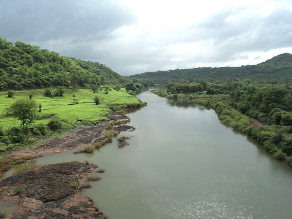
Above: Mahadayi River (Photo: oneindia)
Introduction
Goa, twenty fifth state of the Indian Union, is small but picturesque state, famous all over the world as “The Tropical Paradise of Tourists”. Ensconced on the slopes of Western Ghats which skirts its eastern boundary and lapped by the blue expanse of the Arabian Sea in the West, Goa admeasures an area of about 3,702 sqkm. Situated between Karnataka and Maharashtra, Goa is bounded on the North by the Terekhol river, surrounded on the South and East by Karnataka while on the West is the Arabian sea. This state is divided into two districts, North and South, administered from Panaji, the capital city and Margao, respectively.
Eleven rivers are sustaining the Goan ecosystems. These rivers have sustained the earliest forms of human habitation. The discovery of rare Stone Age carvings on the banks of Kushavati and Zarme rivers stands testimony to this. From the period of Satvahanas, Chalukyas of Badami, Bhojas Kshatrapas and Abhiras, Traikutas of Konkan, Kalachuris, Mauryas of Konkan, Shilaharas, Kadambas…. the Goan rivers have encouraged development of civilization. However excessive load of anthropogenic activities such as mining, tourism etc. have been affecting these rivers from past few decades. While many of the big rivers are critically polluted, many small ones face threat of extinction. Urgent steps need to be taken to protect the rivers of this state which is more intimately linked with its rivers due to unique physiography.
Main Rivers of Goa
Terekhol, Mandovi, Baga, Zuari, Colval, Saleri, Mandre, Harmal, Sal, Talpona and Galjibag are the eleven rivers of Goa which are known as the lifelines of the state. Due to the extent of their drainage areas and the human attraction they hold, these main eleven rivers and their 42 tributaries are significant, not only as the source of potable water but they provide irrigational facilities to agriculture, produce biotic and mineral resources, transport ore from the mining areas to the port and ferries men and goods to different parts of the state. Most importantly they support various forms of eco-systems of this state.
Of these 11 rivers, nine are prominent ones, flowing generally from East (Western Ghats) to West (the Arabian Sea).[1] Most of these rivers originate in the Western Ghats but soon lose their energy as they wander through the Midlands and the Coastal plains to discharge into the Arabian Sea.[2] Throughout the course of these rivers an intricate system of wetlands, tidal marshes and cultivated paddy fields interconnected by canals, inland lakes, bays, lagoons and creeks governed by regular tides.[3] Table-1 gives some details of these rivers. Among these rivers, Mandovi and Zuari alone drain 2553 Sq. Km, about 70% of the total geographical area of Goa.

Out of nine rivers, five originate and flow exclusively within the state boundaries and do not have any interstate implications.[4] However, river Terekhol and Chapora originate in Maharashtra state while Mandovi originates in Karnataka.
| Table 1: Details of River Basins of Goa | |||
| Source: Master plan for Madei/Mandovi River Basin a report by the panel of expert (2001)http://shodhganga.inflibnet.ac.in/bitstream/10603/8494/11/11_chapter%202.pdf | |||
| Sr. No | Name of the River Basin | Length within the state (Km) | Basin area (Sqkm) |
| 1 | Terekhol | 26 | 71 |
| 2 | Chapora | 32 | 255 |
| 3 | Baga | 10 | 50 |
| 4 | Mandovi | 52 | 1580 |
| 5 | Zuari | 145 | 973 |
| 6 | Sal | 40 | 301 |
| 7 | Saleri | 11 | 149 |
| 8 | Talpona | 32 | 233 |
| 9 | Galgibag | 14 | 90 |

Basin Boundaries and Physiography
Goa can be broadly divided into three physiographic divisions namely the Sahyadri – in the east, the Plateaus- the central portion of Goa plains and the Coastal and River Plains of Goa.[5]
The range of Sahyadris along the Eastern periphery of the half-moon formation that Goa becomes forms numerous watersheds in their midst and act as source of water for most of rivers that flow down from them through Goan territory.[6] The river valleys of these highly erosive westerly flowing rivers are typically ‘V’ shaped in the mountainous region of Western Ghats but broaden in central midlands and become ‘U’ shaped in the low lands and coastal plains.[7]
Sahyadris occupy an area of about 600 sqkms of the state with an average elevation of around 800 meters above the mean sea level (MSL).[8] The plateaus constitute central portion of Goa with heights ranging from a hundred meters down to thirty meters (100 meters to 30 meters from the MSL). The state has maximum 105 kilometers of Coastline in length significantly broken up by the large estuaries of Mandovi, Zuari and other minor rivers. River Zuari and Mandovi together constitute one of the most fertile areas in the entire Konkan coast land and provide ideal condition for growth of mangroves.
Riverine islands are another distinctive feature of Goan landscape. Most of the rivers are responsible for the creation of estuarine and riverine islands and their ecosystems. There are almost 100 riverine islands that are colonized by vegetation and are not much known since they are in small size and are prone to erosion. Most of these riverine islands are inhabited but have significant patches of vegetation.
Paradox of high precipitation and low per capita water availability
Situated on the windward side of the Sahyadris, Goa experiences average annual rainfall ranging from 3000 to 5000 millimeters. The coastal belt receives 4000 mm rainfall while the Western Ghats receive more than 5000 mm rainfall annually. Draft State Water Policy (2015) for Goa states that despite copious annual rainfall, rivers of Goa have very low flow for the non-monsoon months resulting in scarcity of drinking water for the period especially in the months of April to start of June. Moreover, the narrow width of the state, steep slopes of Western Ghats, porous sub-stratum, non-uniform distribution of rainfall over time and space cause temporal imbalances of water availability in the state. This also explains the paradox that though Goa is situated in high precipitation zones, it has one of the lowest per capita fresh water availability.
Madovi and Zuari: Two most important rivers of Goa
Goa’s Riverine landscape is dominated by Mandovi and Zuari rivers. In fact according to the recent findings of National Institute for Oceanography during the last glacial period, i.e. 20,000 years ago, both rivers, Mandovi and Zuari, flowed through the rocky terrain as a single river system before branching out separately.[9]
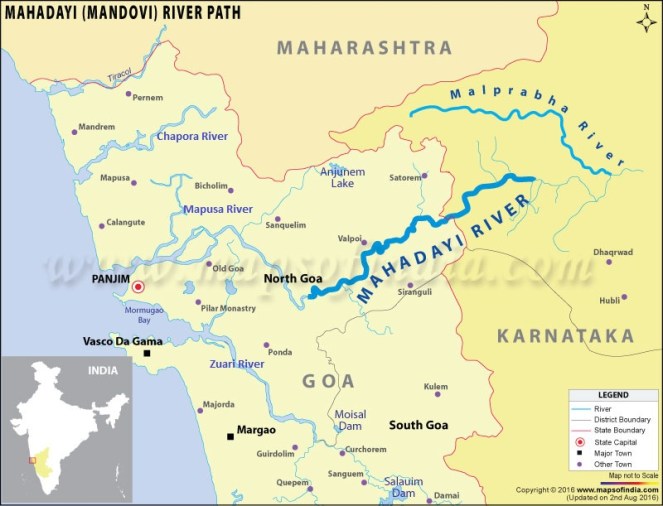
The Mandovi also called Mahadayi rises at an elevation of 600 m in the main Sahyadris above the Kelil Ghat in a Degao village of Belgaum district of Karnataka state, located on the western fringe of the Karnataka Plateau. Flowing for 29 km through Uttar Kannada District of Karnataka State the river enters Goa State via Sattari Taluka of North Goa District. Flowing a length of 52 km within the Goa State it falls into Arabian Sea at the Marmagao Bay near Panjim. Catchment of Mandovi River lies in Goa and partly in Karnataka making it an interstate river. Within Goa State the Mandovi River drains an area of 1,580 sq km covering about 42% area of the state.
In the upper reaches of the Sattari valley, this river is called the Mhadei (meaning Great Mother). After its confluence with the Khandepar river at Bembol (Bicholim) it is called Mandovi till it meets the Arabian Sea ahead of Panaji. Mhadei River is an important tributary of Mandovi holds a great ecological significance for the state. About 85% of the area of Mhadei watershed is forest and is home for Mhadei Wildlife Sanctuary.

While Mandovi has the largest basin in Goa, Zuari River is the longest river in the state and has second largest basin. Zuari is believed to have been known in the earlier times as the Aghanashini, the destroyer of sin.
Zuari’s source water; lies entirely within the state, with the inter-state boundary almost following the water divide. Referred to as a tidal river, Zuari originates in the Dighi Ghat of the Karnataka part of the Sahyadri Hills and after flowing a zigzag stretch of about 145 km joins the Arabian Sea at Mormugao – Dona Paula point. Zuari basin extending from Netravali to Panjim covers an area of about 975 km2 and constitutes about 27 % of the total area of Goa. The basin has forest area of 31.4% and hosts Netravali Wildlife Sanctuary.
Waters of Mandovi and Zuari are extensively used for drinking and agriculture purposes. Mandovi also serves as an important internal navigation route for commercial purpose. Panaji, the state capital and Old Goa, the former capital of Goa, are both situated on the left bank of the Mandovi.
Biodiversity of Mandovi and Zuari Basins[10],[11]
Mhadei sanctuary formed in 1999, hosts one of the lushest and verdant pockets of the Western Ghats Biodiversity Hotspot. This comparatively new sanctuary area in Goa is located in the Northern Part of the state, near the village of Valpoi. The sanctuary covers a vast area of 208 sq. km. Netravali Wildlife Sanctuary (NWS) is located in Sanguem Taluka of South Eastern Goa. It is spread in an area of 211 sqkm and is connected to the Mhadei Wildlife Sanctuary. Together they cover an area of 420 sqkm. The sanctuary is named after the Netravali or Neturli River a key Tributary of Zuari that originates in the sanctuary. Netravali Wildlife Sanctuary is an extremely significant source of fresh water for Goa. The Sanctuary in turn forms a contiguous protected area along with Goa’s Mhadei Wildlife Sanctuary; and Karnataka’s Bhimgad Wildlife Sanctuary.

These sanctuaries are thickly forested with moist deciduous vegetation and some evergreen species. Apart from a large number of commonly seen animals like Indian Gaur, Barking deer, civet, wild boar etc. the animals seen rarely include the Black Panther, Sloth bear, Leopard, Tiger, Dhole, Jungle cat, Mouse deer, Giant squirrel, Flying squirrel, Indian pangolin and the Slender loris which is an endangered species. The sanctuaries are also home to more than 255 species of birds. Netravali Sanctuary has been declared an International Bird Area. The sanctuary is also home to a number of amphibians.
Mandovi and Zuari Estuaries
Rivers, Mandovi and Zuari are joined by Cumbarjua canal near their estuaries giving rise to the largest estuarine complex of Goa which is considered as lifeline of Goa’s economy.[12] A luxuriant growth of mangroves is found bordering the estuaries thereby playing a major role in protecting the coast from heavy wave action and winds.
The total area covered by the estuaries in Goa including the major Mandovi Zuari estuarine complex is approximately 12,000 ha of which the mangrove forest occupy 2000 ha.[13] About 900 ha of mangroves are found along the Zuari estuary, 700 ha along the Mandovi estuary and 200 ha along the Cumbarjua canal.
The Mandovi and Zuari estuarine network along with the Cumbarjua canal is used extensively for transport of goods (mainly iron ore), for fishing, and for dumping domestic and industrial waste. The increase in population and industrial activities in Goa, during the last few decades, has increased the dependence of the state on the said network.
Threatened existence of other small rivers
Other than Mandovi and Zuari, other small rivers of Goa occupy only 30% of the state’s geographical area. Though these rivers are small in size (length varying from 10 to 40 km) they are locally as significant and sustain livelihoods of the villages and hamlets that they flow through. Many of them also face increasing threat to their existence due to excessive load of anthropogenic activities.
Like Mandovi, Terekhol and Chapora Rivers are also interstate rivers as they originate in Maharashtra. Terekhol is the northernmost river which originates in the Manohargad in the Sahyadris and running along the border of Goa for 27.5 kms discharges itself into the Arabian Sea. Patradevi is the entry point of Terekhol in Goa. Torxe, Khadshi and Pedne are its main tributaries. Interestingly except for the historic fort of the Terekhol tract on its right bank, only the left bank portion lies in Goa. Terekhol sustains the traditional livelihood of thousands of people of Pernem.
Chapora rises above Ramghat at Tudye in Chandgad in Maharashtra and follows a zigzag course, demarcating the border of Pernem, Barde and Bicholim before debouching into the Arabian Sea near the historic fort of Chapora. The 32 km long Colval River enters Goa at Ibrampur village of Pernem. Sal, Kalana Virnoda and Parshe are the tributaries of the Colval. It is called Tillari in Maharashtra and has Tillari Multipurpose Project and Tillari Hydropower Project , both in Maharashtra.
Sal which is the important river of the South Goa, rises near Verna and flows for 35 km parallel to the coast meets the sea at Betul. Talpan is the important river of Canacona. Originating in the Ambaghat in Canacona, the river runs 31 kms long course. Galjibag is also one of the important rivers in the South Goa. Two rivers of Canacona namely Mashe and Loliye are the main feeders of Galjibag. It meets the sea near Mashe.

Many of the small rivers of Goa are on the verge of extinction. For example the Baga River which is one of the small river of Goa that emerges from the forested areas of Assagao of Bardez and falls in Arabian Sea near Baga village has been witnessing massive tourism activities since last three decades. To provide facilities, hotel and restaurants has increased by manifold in Baga and surrounding areas. Garbage disposal and sewerage treatment too, has resulted in pollution of Baga River. Several encroachments have reduced the river to gutter. This river has already on the path of privatization. Some of the private resorts have started boating and cruising facilities for the tourists. These various activities have resulted in seriously destroying the natural drainage of the river.
Similar is the case for many other small rivers. Existence of 12 km long Saleri River originating in the forested areas bordering Barcem and Gokuldem villages of Quepem has been threatened by increasing agriculture, deforestation and other man-made activities. 8.75 km long river Mandre which originates from the jungle of Corgao, feeding various hamlets of Mandre, Corgao, is on the way of extinction due to anthropogenic activities. Similar is the case of Harmal River which originates in the hilly areas of Corgao and flows westward for the distance of 11km before falling in the Arabian Sea. The haphazard projects undertaken for tourism purpose have adversely affected the natural course of the river.
Impacts of mining on rivers[14]
Goa’s North to South length is 105 km length, of which 95 km, mostly the plateau region comes under mining stretch. Ongoing operation of more than 800 mines many of which are located just few meters away from the river banks are causing severe pollution due to mining rejects. River banks dotted with numerous loading points for the mines have been destroying the riparian belt.
Every year the heavy monsoon run off carries the overflow and wash off from the huge quantum of mining rejects into the rivers. These mining rejects along with slime and pumped out turbid water from deep mining pits are then transported further downstream by the rivers. When the river traverses flat terrain, the velocity gets reduced and mining reject which is carried in suspension gets settled in the channel, resulting ultimately in the overflowing of banks and inundation of low-lying areas along the banks. Silt settled in estuarine zone changes the geomorphology of the estuarine bed and results saline water intrusion to the upstream.
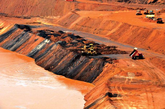
Salaulim dam built on Salaulim River, a tributary of the Zuari River, which supplies drinking water to 55% of Goa’s population has more than 15 mining leases in the catchment of its reservoir. River Khandepar, tributary of Mandovi, which is source of drinking water to 30% of Goa’s population has 21 mines within its catchment. The siltation problem is acute in the Khandepar river. The silt often chokes the filter beds of the water treatment plant. The Bicholim River that once was navigable has lost its navigability on account of siltation. The main rivers of Goa, the Mandovi and Zuari are also heavily polluted due to mining activities. While Zuari has 10 operating mines in its catchment Mandovi has 27 mines depositing whopping 70,000 cubic tonnes of iron particulates every year in the Mandovi River.
State Mining Policy of Goa does not acknowledge the impact of the sector on rivers and water bodies and fails to lay guidelines regarding distance of mines from water bodies, sustainable waste disposal, safe transport of ore from rivers, etc.
The haphazard and the unregulated growth of alluvial sand mining has also damaged the river ecosystem. Even after criticized heavily by the Supreme Court on the unrestricted, unplanned and illegal sand mining going on in the rivers of Goa excavation of sand since last two decades is going on in haphazard way by increasing the depth of the river. The traditional fishermen have already suffered losses. Government has not designed and implemented mechanism for long term control measures for exercising check on illegal sand mining.
For a small state like Goa a whopping 23% of its rivers are critically polluted. Central Pollution Control Board has identified 8 river stretches in Goa which are critically polluted. They include stretches of Mandovi, Assonora, Bicholim, Chapora, Khandepar, Mapusa, Sal and Valvanti rivers are polluted. Total 84 km of river length is polluted in Goa. Details are given in Table-2.
| Table 2:Polluted River Stretches of Goa | ||||||
| Source: Central Pollution Control Board
(http://cpcb.nic.in/upload/Publications/Publication_528_RESTORATION-OF-POLLUTED-RIVER-STRETCHES.pdf ) |
||||||
| Sr. No. | River Name | Polluted Stretch | Towns Identified | Approx length of stretch (km) | BOD Range / Max Value | Priority |
| 1 | Mandovi | Marcela to Volvoi | Marcela, Volvoi | 10 | 3.9 | V |
| 2 | Assonora | Assonora to Sirsaim | Assonora | 5 | 7.0 | IV |
| 3 | Bicholim | Bichorim to Curchirem | Bicholim | 6 | 3.9 | V |
| 4 | Chapora | Pernem to Morjim | Chikhli, Siolim | 18 | 5.0 | V |
| 5 | Khandepar | Ponda to Opa | Ponda | 10 | 3.9 | V |
| 6 | Mapusa | Mapusa to Britona | Mapusa | 16 | 6.2 | IV |
| 7 | Sal | Khareband to Mobor | Margao | 14 | 3.2-10.6 | III |
| 8 | Valvant | Sankli- Bicholim to Poreim | Bicholim | 5 | 3.1 | V |
In the capital city of Goa, the river Mandovi has become attraction for the indigenous and foreign tourists. For gambling, as the floating casino boats are there in Panaji since last few years, polluting the river water as well as social environment. It has been indicated that the untreated waste water, sewage that are released is responsible for increasing pollution of the river water.
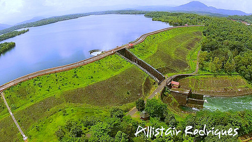
National Register of Large Dams maintained by Central Water Commission lists five dams in Goa. The details are as follows-
Proposed ‘nationalization’ of Goan Rivers
The Inland Waterways Authority of India (IWAI) of Union Ministry for Shipping has identified six rivers of Goa as national waterways and has proposed “nationalisaion” of these rivers under the National Waterways Act enacted in March 2016. Goa’s six rivers are included in the schedule of 111 national waterways. The purpose primarily is to develop waterways.
The pact is to be sealed between the Governments of Goa, India and Mormugao Port Trust (MPT) as a logistic partner.[15] Goa will decide on river developments while central government will call the shots on finance and planning.
The Central government has already notified six rivers of Goa as national waterways.[16]
In September, 2016, IWAI signed a memorandum with Dredging Corporation of India and MPT to accelerate the development of Inland Water Transport. 41 km length of the Mandovi, 50 km of Zuari, 33 km of Chapora, 17 km of Cumbharjua canal, 27 km of Mapusa and 14 km of Sal have been notified as national waterways.
Thus total 182-Km river stretches in Goa will be subjected to dredging, river training works, concretization of banks, and construction of navigation aids such as light houses, jetties etc. However, this move has been opposed as it would adversely hit marine environment and the livelihood of the fishing community and the rights of Goa over all these six rivers. Locals have alleged that the nationalisation has been happening to help the coal importing firms to use the inland waterways, and not to promote the use of rivers for transportation.
Ecological Significance of Mahadayi for Goa[17]
A very large quantity of fresh water for Goa flows down from the Mandovi. Core catchment of Mandovi or Mahadayi as it is called lies in the heavy rainfall, thickly forested, approximately 200 sq km of mountain topography of Khanapur taluka of Karnataka State. Every variation in the Mahadayi water level in these upper reaches is thus crucial for Goa’s water security.
In that sense Goa has been at the mercy of its two larger and powerful neighbouring states viz. Maharashtra and Karnataka. Ambitious plans of these states to create large storages or divert waters close to the sources of rivers flowing into Goa have made the State of Goa vulnerable. This in fact is one of the biggest threats that are now looming over the valley is the Karnataka Government’s plans to divert a large quantum of water from the Mahadayi River and its tributaries to the Malaprabha river basin to help the acute water scarcity faced by the region in the Malaprabha basin. The massive diversion of the Mahadayi water from this area will see a quantum drop in the fresh water flows and silt flowing down from the denuded mountain ranges from across the border and will adversely affect the health of Mahadayi basin.
Mahadayi Water Dispute[18]
Mahadayi River has been making headlines because of the inter-state water sharing dispute over its water between Karnataka and Goa. Dispute triggered in 2002 when Karnataka began the work on diversion of Mahadayi waters to Malaprabha River (a tributary of Krishna River).
Karnataka’s dual plan of Hydropower generation and river diversion for irrigation and drinking water included multiple dams like Kotni reservoir, Irti, Bailnadi and two diversion dams planned, Kalasa and Haltar. Total submergence of these dams would be 2915.5 hectares, mostly Forest Land including part of Mahadayi Wildlife Sanctuary. Karnataka started construction and digging canals at Kalasa Bhanduri, just 1.2 kms from the Mhadei Wildlife Sanctuary without securing any Environment, Forest or Wildlife Clearances. Work came to a halt the same year when in July 2002 Goa made a request under Section 3 of the Inter-State River Water Disputes Act, 1956 for constitution of Mahadayi Tribunal. After a long dragged process of eight years and Goa approaching the Supreme Court, Mahadayi Water Disputes Tribunal (MWDT) was finally established in November 2010.
Karnataka’s original application to MWDT sought allocation of 24.15 TMC water from Mahadayi for consumptive use outside the basin and 13. 347 TMC non consumptive use for generating hydropower. Since December 2015 Karnataka has been seeking an interim relief for granting 7 TMC water for drought relief in Malaprabha Command. Karnataka’s argument for demanding 7 TMC is hinged on reduced water inflow of Malaprabha reservoir. Claiming that Goa has surplus of 14.32 TMC water after catering to its estimated demand of 94.4 TMC till 2051 Karnataka went ahead to say that ‘200 TMC go waste to Sea’ in Goa.
Goa however maintained that the forecasted demand does not include environmental flows for Mahadayi basin which it also claimed is not a surplus basin. While Goa could support its argument with factual evidences like 1,81,470 ha area under Sugarcane in Malaprabha basin which guzzles 160 TMC water annually or Pepsico plant which is supplied with 4 lakh liters on Malaprabha water every day; Karnataka failed to provide in front of the tribunal details of the schemes it proposed, had not secured requisite clearances, and also had not assessed the impact of water diversion on Mahadayi River.
Finally in July 2016 the Tribunal passed Interim Order, rejecting Karnataka’s request. Court passed strictures over Karnataka for calling the Mahadayi water reaching sea as ‘waste’.
This however is only an interim order and dispute is likely to carry on.
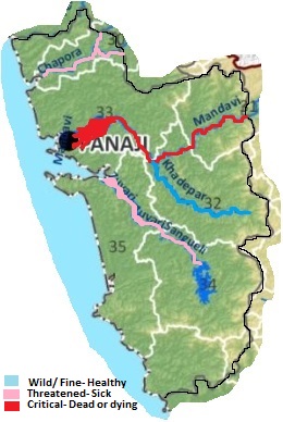
Goa River Health Card
River Health Card has been prepared based on basin information assessed till now and few additional sources (links provided).
Rationale behind specific categorization has been given wherever necessary.

Need for river conservation policy
In the times of worsening inter-state water disputes, increased ill effects of mining, growing tourism and associated pollution; rivers of Goa need to be protected on priority. Need of the hour is for the state to have a comprehensive river conservation policy and also to make the best use of the available surface water resources. As the rivers are the main source of the fresh water, the state has to plan a strategy to conserve and protect the unique ecological, cultural heritage of Goa’s river basins and the sustainable economic activities dependent upon them and their life support systems.
Though, all the rivers flowing in Goa are small in size, they are a source of life and livelihood and there is urgent need to draw a visionary plan for sustainable use of the river in the development of locals by creating independent basin management cell for each river for looking into protection and conservation of the water resources. From source to mouth, river is a living entity and that is why a master plan drawn should focus on the sustainable development with the utmost respect to environment ecology and wildlife. In July 1997, the Goa River Conservation Network (GORICON) was established under the initiative of Nandkumar Kamat with Rajendra Kerkar as the state organizer to empower the riverine people to fight for their traditional, ecological, cultural, social and economic rights and for the sustainable use of the biotic and abiotic resources. GORICON, is an initiative of riverine people of Goa to prepare peoples master plan for conservation and sustainable and utilization of the riverine resources. As Goa’s Water Security is relied on these rivers and tributaries, there is urgent need to a well-planned strategy for protecting them for present and posterity.
This report has been jointly prepared by Shri Rajendra P. Kerkar, Amruta Pradhan (SANDRP) and Parineeta Dandekar (SANDRP)
Notes:-
- This report was commissioned for India Rivers Week 2016.
- Its a short description of a detailed report which can be seen here Goa Rivers Profile
- You may also like to see rivers profiles for Rajasthan, West Bengal, North-East India, Maharashtra, Haryana, Uttarakhand , Himachal Pradesh, Kerala, Karnataka , Jharkhand States
- The same report can also be seen on India Rivers Week Blog
REFERENCES:
- T. Gune, Gazeteer of India, U. T. of Goa, Daman and Diu, Part:I, Goa, 1977.
- Regional Plan for Goa 2001 A. D., Government of Goa.
- Fish, Curry and Rice edited by Dr. Claude Alvares, the Goa Foundation, 2002.
- Various articles on the Rivers of Goa by Dr. Nandkumar Kamat.
- Ecological and economic aspects of alluvial sand mining from Terekhol and Colvale Rivers- edited by Dr. Nandkumar Kamat-1994.
- Goa State Biodiversity Strategy And Action Plan- Goa Foundation, 2001.
- CSE’s Sixth Citizen’s Report on the State of India’s Environment.
End Notes:
[1] http://www.india-wris.nrsc.gov.in/wrpinfo/index.php?title=Goa
[2] http://shodhganga.inflibnet.ac.in/bitstream/10603/7539/6/06_chapter%201.pdf
[3] http://goaenvis.nic.in/estuary.htm
[5] http://shodhganga.inflibnet.ac.in/bitstream/10603/12459/9/09_chapter%203.pdf
[6] http://www.cgwb.gov.in/District_Profile/Goa/NORTH-GOA.pdf
[7] http://www.cgwb.gov.in/District_Profile/Goa/NORTH-GOA.pdf
[8] http://shodhganga.inflibnet.ac.in/bitstream/10603/8494/11/11_chapter%202.pdf
[9] http://timesofindia.indiatimes.com/city/goa/20000-years-ago-Mandovi-and-Zuari-flowed-as-one-river/articleshow/52181438.cms
[10] http://goa-tourism.com/GTDC-holidays/see-natures-trail-mhadei-wildlife-sanctuary.htm
[11] http://www.sanctuariesindia.com/netravali-wildlife-sanctuary/
[12] http://goaenvis.nic.in/mangrove.htm
[13] http://goaenvis.nic.in/mangrove.htm
[14] http://www.indiawaterportal.org/articles/mining-havoc-impact-mining-water-resources-goa-article-dams-rivers-and-people
[15] http://www.heraldgoa.in/Goa/Monsoon-Assembly-Session/Govt-allays-fears-over-nationalisation-of-inland-waterways/105025.html
[16] http://englishnews.thegoan.net/story.php?id=23513#sthash.EMvvtHA9.dpuf
[17] http://mohan-pai.blogspot.in/2008/08/mahadyimandovi-river-valley.html
[18] https://sandrp.wordpress.com/2016/08/02/mahadayi-water-disputes-tribunal-trouble-brewing-in-paradise/
