Floods · Nepal

Massive landslide blocks Sunkoshi River, Downstream Nepal-India under threat;

Attempt to blast the dam starts; 8 killed, many more at missing, at risk;
Google map of the location, the landslide location seems just upstream of the dam

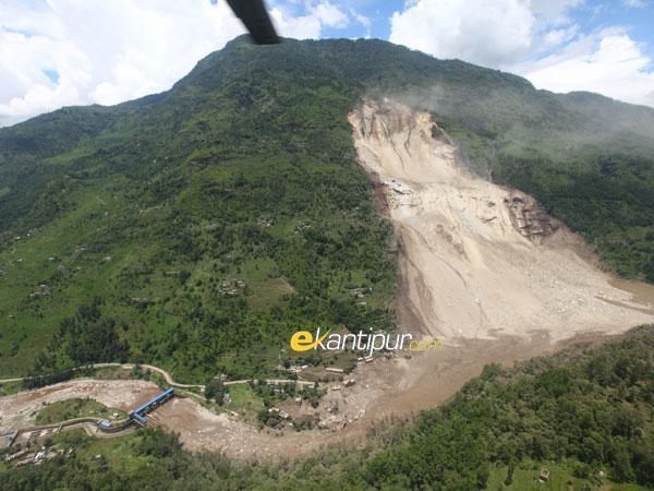
A massive landslide at around 2.30 am on Aug 2, 2014 has blocked the flow of the river Sunkoshi in Nepal. Twelve hours later and after first failed attempt by the Nepali army to blast the artificial dam, the reservoir behind the dam continues to swell. Already eight people have been confirmed dead, over 300 are reported missing[1]. Many more are at risk in the downstream Nepal and further downstream India. Sunami Power house has already been inundated. The Landslide seems close to an existing dam on the river. If this is true, when the landslide dam bursts either due to the army efforts or due to the water pressure, it is likely to take the dam with it and this could increase the downstream impacts.

A view of the landslide dam photo courtesy Setopati.com

Prof David Petley wrote to SANDRP about this: “It is very dangerous indeed.  I know this site very well as we have been working in that valley for a decade or so. I suspect that the breach will happen quite quickly and will be very damaging.”

Bishyari much more devastating than GLOFs” Former Water Resources Minister and well known water expert Dipak Gyawali told SANDRP: “Bishyari is the Nepali word for this kind of a “landslide dammed lake outburst flood” much more devastating than the GLOFs . This is a geo-hydrological phenomenon and as the pictures show, brings down entire mountains with thick forests on them. This one was on an old landslide still active but exacerbated by the recent spate of hydropower as well as road blasting.” Jayanta Bandyopadhyay and Dipak Gyawali were the first to put the word ‘bishyari’ in English, in a 1994 much-quoted article in Mountain Research and Development.

Massive scale of the landslide dam, photo thanks to Kathmandu Post

Indian border is about 260 kilometers downstream from the landslide when measured along the river and on the way there is also the Kosi Barrage at Bhaimanagar / Rajbiraj (correction from earlier reported distance).

A view of the massive landslide dam, photo courtesy Nepalhub.com

This morning, an email from our friend Ratan Bhandari from Kathmandu informed of this development, and it seems like a bad news to precede Indian Prime Minister Narendra Modi’s visit to Nepal, but it could also be a timely wake up call not to go for massive interventions in the Himalayan states.

Rising reservoir behind landslide on Sunkoshi river, Nepalhub.com

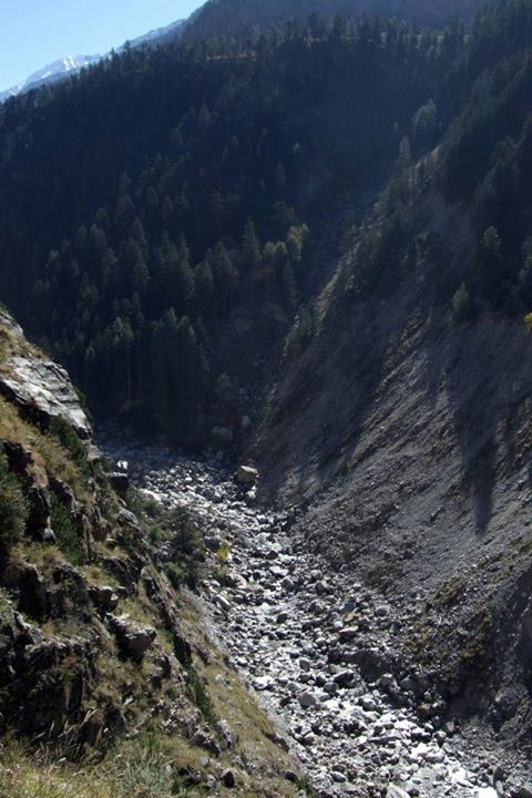
The massive landslide blocked Sunkoshi River at Mankha VDC in Sindhupalchowk[2] district. Around two dozens houses were buried in the landslide. The landslide has also buried Arniko Highway at Dam Site in Mankha VDC. Locals in Barhabishe, Lamesanghu, Khadichaur, Dolalghat, among other surrounding areas have moved to safety fearing that the blocked river may burst anytime. A Nepal Army chopper has been deployed to intensify the rescue work. The government has mobilized security forces to break a landslide dam that has blocked the flow of water in Sunkoshi River[3] in Jure of Mankha VDC, Sindhupalchowk.

A view of the dam and the river, photo courtesy Setopati.com

The Central Natural Disaster Relief Committee (CNDRC) has asked the Ministry of Home Affairs[4] to declare the areas downstream the blocked Sunkoshi River, from Jure of Sindhupalchok to Nepal-India border, “crisis-hit region” as the threat of outburst floods loomed large. It is hoped that the Indian authorities in downstream Indian areas are alert and doing necessary steps for the protection of life and property in India.

Landslide and the dam photo courtesy onlinekhabar.com

According to the Ministry of Home Affairs, the water level rose to above 130 metres. About 100 houses on the bank of the river have been submerged in Jure of Ramche VDC-5[5], the Araniko highway itself has been blocked.

Houses affected by landslide, photo courtesy onlinekhabar.com

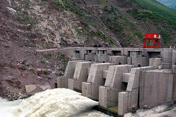
The Sunima hydropower project (constructed in 2004-5) that has already been inundated is a 2.6 MW project built by Himal Hydro[6]. The dam of the 10.5 MW Sunkoshi hydro project (completed in 1972 with Chinese aid) is immediately downstream from the landslide, and is likely to face damage along with its power station further downstream whenever the dam breaches.

A view of Sanima Power House in Sindhupalchok, photo courtsy Himalayan Times, Nepal

Dr David Petley, who has traveled in the area writes in his blog[7]: “However, it is now a crisis.  In the peak of monsoon season the river flow is high, and the images show that the lake is filling quickly.  The images suggest that there is no reason to be confident that the dam will not breach rapidly when overtopped – indeed, quite the opposite I think as the length of the dam is not large and the materials appear to be fine grained.  A breach now could generate a very large flood; when full the effects could be very serious… So what to do? Well of course the first measure is to evacuate people downstream, and this has started.  The second is to put a warning system in place, probably at this stage consisting of an observation team with appropriate communications.  The third will be to start to excavate a channel, which will require heavy machinery… This is a very difficult problem to manage, so Nepal should seek international help.  The best qualified people are the teams that dealt with the valley blocking landslide crisis after the Wenchuan earthquake in China.  Given the strategic importance of this road, the Chinese may want to help.  However, time is very limited.”

About the possible causes of the massive landslide, this article says it is partly due to the after effects of last year’s landslide at the same site: http://www.myrepublica.com/portal/index.php?action=news_details&news_id=80211.

It also says that the district has seen such landslide blocked rivers causing disasters in the past too including the ones in 1982 (in Balephi village of the district when 97 people had lost their lives) and 1996 (54 people had died due to a landslide caused by dam outburst flood in Larcha, another village of the district).

A view of the blocked Sunkoshi River in Sindhupalchok, Photo courtesy Himalayan Times Nepal

We hope all such necessary steps are urgently taken and Indian government, Bihar state government and Nepal government coordinates in this on urgent basis.

A man taking a photo of the artificial lake formed due to Sunkoshi River Blockade in Sindhupalchok

Himanshu Thakkar, SANDRP

PS: According to http://hydrology.gov.np/new/bull3/index.php/hydrology/station/graph_view?stationId=104&deviceId=91&categoryId=6, the inflow is about 150 cubic meters per second, so in 11 hrs the volume stored would be about 6 million cubic meters. The impact on the downstream would depend on the way this water gets released. (This link thanks to comment on Dave Petley blog.) The lake overflow could have just started at around 1.30 Indian Std Time, but it is not clear what is the outflow rate.

PS 2: Comments from Dr Dinesh Kumar Mishra:
A. Flood warning has already being issued by the district administration in Saharsa about 3 hours ago that there is an imminent danger of floods along the embankment and the most vulnerable point is the site of 1984 breach.

Map with orange line showing the path that the flood pulse from the landslide dam will take to reach Kosi in India, FMIS map

B. There is some activity at the Bhimnagar barrage with officials and engineers keeping an eye over the situation. I am told that the Government has asked its officers of the Kosi Project at Birpur to move to safer places. Otherwise, there is calm at Birpur.

C. I have just received a message from a friend of mine from village Bela in Marauna block of Supaul district (this village is located within the Kosi embankments) and they have not received any warning from the Government and only know that something odd has happened in Nepal.

D. Villages near Madhepur block along the western embankment of the Kosi have not received any warning. They are not aware if anything wrong has happened in Nepal.

E. खबर है की सुन कोसी नदी की धारा पहाड़ धंसने की वजह से बाधित हो गयी है। इस की वजह से नदी के सामने बाँध बन गया है और ये किसी भी समय टूट सकता है जिस से निचले इलाकों को खतरा हो सकता है। मेरी अभी सहरसा शहर, सिमरी बख्तियारपुर के कठघरा गावों, ग्राम बेला (मारौना प्रखंड), जिला सुपौल; बीरपुर (कोसी बराज के निकट), कमलपुर (प्रखंड निर्मली) – जिला सुपौल और मधेपुर के अपने मित्रों से बात हुई है। सहरसा से खबर है कि वहां प्रशासन ने संभावित बाढ़ की चेतावनी दी है मगर सुपौल में अभी तक ऐसा नहीं हुआ है। बेला, कठघरा, भेजा में लोगों को इतनी जानकारी तो है की नेपाल में कुछ गड़बड़ हुआ है और नदी मे ज़्यादा पानी छोड़े जाने की आशंका है पर उस से ज़्यादा जानकारी नहीं है। सहरसा में कोसी तटबंध के किनारे बसे लोगों को संभावित बाढ़ के प्रति आगाह किया गया है।

F. (1700 hrs) ये जगह त्रिबेनी के ऊपर सुन कोसी नदी पर है. त्रिबेनी भारत – नेपाल सीमा से करीब ६० की। मी। पर है और जहां भू स्खलन हुआ है वो करीब ७० की. मी. दूर होगा। अगर ये मिट्टी का बाँध टूट जाता है या तोड़ दिया जाता है जैसा की नेपाली सेना कोशिश कर रही है, ऐसा बताते हैं, तो पानी को भारतीय सीमा तक आने मे समय लगेगा और तय्यारी के लिये कुछ समय मिल जायेगा।मेरी अभी बिहार राज्य आपदा प्रबंधन प्राधिकार से बात हुई है और उन्होने बताया की राज्य का आपदा प्रबंधन विभाग सक्रिय है और एन। डी। आर। एफ। के जवान सीमा पर पहुंच रहे हैं। बेला (मारौना प्रखंड , जी सुपौल) वालों ने स्थानीय प्रशासन से बात की थी। उनका कहना है कि आप लोगों का गाओं ऊँची जगह पर बसा हुआ है इसलिये चिंता की कोई बात नहीं है।

PS 3: Just (1600 hrs) called Control Room of NDMA (ph no:  011 26701728) and Mr Kulwinder informed me that Nepal govt informed NDMA at 1136 hrs about this and NDMA in turn has alerted Bihar Govt, Home Ministry, Cabinet Secretariat and others, he said PMO would also be aware of this when I told him PM is going to Nepal tomorrow. They have kept 9th NDRF battalion at Patna/ Kolkata on alert. He was aware that Koshi would be affected. He is not aware of any cooperation from Indian side on this.

PS 4: 1730 hrs: According to reliable sources, there is debate between Nepalese authorities saying that all the gates of the Koshi barrage should be kept open for the flood wave to safely pass and elements on Indian side that, that should wait for the flood wave to come. A contingent of senior officials are being airdropped to the barrage site with  letter from CM.  The second blast at the landslide dam in the meantime managed to lower the upstream reservoir water level by 2 m, but it is not clear if the outflow is continuing or has stopped.

1820 hrs: All 56 gates of Kosi Barrage have  been opened, good to see that better sense have prevailed.

PS 5: Update from http://www.myrepublica.com/portal/index.php?action=news_details&news_id=80146

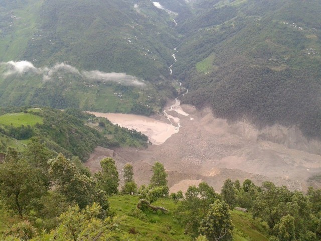
(Nepali time 4:00 pm) “The Sunkoshi River has started to flow after Nepal Army (NA) detonated two explosives. The water volume in the river downstream has increased as compared to the regular one. Authorities believe resumption of river flow will put off possible damages.” The landslide dam has created reservoir of 90-100 m height.

From: http://www.myrepublica.com/portal/index.php?action=news_details&news_id=80184
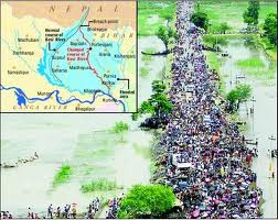
“Three eastern districts, Sunsari, Saptari and Udayapur have maintained high alert to remain safe from the possible Saptakoshi River inundation. The local administration has already begun its task to alert the people of riverside in Sunsari to shift them to safer places while the administration in Udaypur and Saptari districts have made arrangements to inform people about the blockage of river and aware people about the possible flooding, said Sharma. It is possible that as many as 500 VDCs in the districts and Bihar State of India would be inundated if the blocked landslide debris opened at once and the Koshi barrage was damaged.”

From: http://www.myrepublica.com/portal/index.php?action=news_details&news_id=80180

“Some 14 VDCs in Khotang district are at high risk of inundation after the landslide in Sindhupalchok district blocked the passage of Bhote Koshi River. Bahunidanda, Dikuwa, Chyasmitar, Durchhim, Dhitung, Rajapani, Batase, Chichkiramche, Barahapokhari, Saunechaur, Suntale and other VDC that are on the side of Sunkoshi river are at high risk of flooding. The District Administration Office and District Police Office have urged the locals to shift in the safe areas to remain away from the possible risks. Assistant Chief District Officer Arjun Rai said that the locals of the low land site have been asked to move to higher ground. ”

From: http://www.myrepublica.com/portal/index.php?action=news_details&news_id=80181

“‘Sri Lanka tapu’, which lies in middle of Sapta Koshi River, has been declared flood crisis zone in view of possible flash flood caused by likely bursting of artificial lake formed by landslide in Sunkoshi River. Local administration declared the area flood crisis zone which has settlements of over 12,000 persons on Saturday.  Security personnel along with government and non-government organizations have been deployed to aware and shift locals to safer places in east and west of the island which is home to indigenous nationalities of Tarai and Hilly regions. Chief District Officer Sudarshan Prasad Dhakal said that security agencies have been directed to shift children and elders along with valuables to a safer place. Local administration has also urged people in seven other VDCs— Barahachhetra, Mahendra Nagar, Prakashpur, Madhuban, Paschim Kusahawa, Shreepur and Haripur— to move to a safer place. The possible flash flood will reach Sapta Koshi barrage in around 10 hours, and all 56 floodgates have been opened in view of possible danger, informed CDO Dhakal. ”

From: http://www.ekantipur.com/2014/08/02/top-story/water-begins-to-drain-out-from-clogged-site-in-sunkoshi-update/393051.html

Water flow has started from Northern side of the landslide dam. Not clear at what time and extent of flow.

PS 6: This is one of the first Indian news reports on this impending disaster:  http://www.ndtv.com/article/india/bihar-orders-immediate-evacuation-as-kosi-river-threatens-four-districts-569722?pfrom=home-otherstories

This is possibly one of the most detailed report on this issue so far: http://www.hindustantimes.com/india-news/10-metre-high-wall-of-kosi-water-surge-threatens-bihar-after-nepal-landslide-govt-begins-evacuation/article1-1247519.aspx

This one seems way off the mark when it says the Kosi barrage is about 270 km from the landslide site: http://netindian.in/news/2014/08/02/00030017/bihar-flood-alert-after-landslide-nepal-blocks-flow-sunkoshi-river

PS 7: The damage to power system in Nepal is much more extensive, and loss of generation to the extent of more than 66 MW may be suffered as per this report: http://www.myrepublica.com/portal/index.php?action=news_details&news_id=80205

“…two iron gates, which diverted water to intake of Sunkoshi Hydropower Project (10 megawatts), was swept away by flood in the wee hours on Saturday morning… Similarly, power supply from 45 megawatts Upper Bhotekoshi Hydropower Project has also been disrupted… Likewise, 11 kV transmission line for evacuating power from Chaku Khola (total 6 megawatts) and Bhairab Kunda (3 megawatts) and another 33kV transmission line for evacuating power from Sunkoshi Hydropower Project (10 megawatts) has also been damaged… Officials at Load Dispatch Center of NEA also said Sunkoshi River flooding may breach dams and affect power supply from Khimti Hydropower Project and others hydropower projects on the Tamakoshi River basin.”

PS 8: This estimates of floodflow from CWC and Indian Embassy in Kathmandu are scary (http://timesofindia.indiatimes.com/india/Bihar-on-alert-as-landslide-in-Nepal-threatens-Kosi-deluge-massive-evacuation-on/articleshow/39506010.cms):

“The Central Water Commission has estimated a discharge of 14 lakh cusecs of water but the Indian embassy in Kathmandu has informed the National Disaster Management Authority about the likely discharge of 25 lakh cusecs of water post blast. In either case, 40% of the discharge will gush into Bihar.

The water will take about 12 hours to hit the Kosi barrage which has the capacity of sustaining pressure of only eight lakh cusecs. The flood, if it occurs, would affect a population of 1.5 lakh in Bihar’s eight districts, including 50,000 people in 22 panchayats of Supaul district alone.”

It is well known that Kosi embankment breached in Aug 2008 when flow was below 1.5 lakh cusecs, so even if barrage is able to take 8 lakh cusecs (seems unlikely), embankment is likely breached at much lower flows.

PS 9: From: http://www.myrepublica.com/portal/index.php?action=news_details&news_id=80213

“As the dam resulting from the landslide grew larger by the hour, at least three human settlements became submerged. Damsite bazaar in Mankha-1, Kagune village in Mankha-5 and another settlement in Tekanpur-5 vanished into the water. Security personnel rescued 16 people from Damsite and seven from Tekanpur villages before these became submerged; no one was rescued from Kagune village.

According to Sindhupalchok District Police Office, 26 houses at Damsite, 16 at Kagune and seven houses at Tekanpur disappeared. At Damsite, a school was also buried under the landslide-induced dam.

Local authorities say explosions set off by the NA have slightly reduced the risk of flood outburst. “The risk has been reduced,” said Chief District Officer Gopal Prasad Parajuli. “The water volume in the landslide-induced dam is declining. The blocked water is now flowing through the small channels created by the explosions, albeit only partially.””

A view of water flowing out of landslide dam, photo from myrepublica.com

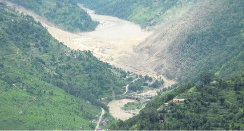
The last para is good news since  it seems to suggest (as can also be seen from above photo) that water has slowly started flowing out and hopefully there is no more accumulation, but slow depletion.

PS 10: Some updates from Bihar (different sources):

At 06:00 AM water level was 1.06 lakh cusec at Kosi Barrage. Water level increasing at the rate of 2-3 thousand cusec per hour. Hish water flow may reach around 1-1:30 PMin Bihar on Aug 3. High alert in 9 districts. (1.Supaul, 2. Saharsa, 3.Madhepura, 4. Khagaria, 5. Bhagalpur, 6.Araria, 7.Purnia, 8.Madhubani 9. Katihar).  Threat of danger till Monday morning (4th August 2014)

Three controlled blast by Nepal Army. First at  01:50 PM, Second at  02:50 PM and third at  03:30 PM for water flowing, it is not clear how much water is flowing out.

PS 11: From: http://thehimalayantimes.com/fullNews.php?headline=Rescue+at+Jure+soon%3B+outflow+of+Sunkoshi+water+normal&NewsID=423063

This is good to know: “‘Outflow of water normal“: Meanwhile, the Sunkoshi River is flowing out of the lake in a controlled rate today, according to the National Emergency Operation Centre (NEOC) of the Ministry of Home Affairs. Water level has not decreased significantly as the volume rate of water flowing in and out of the lake are comparable.”

The same report claims: “According to an official at the NEOC, about half of the chunk of debris that obstructed the River has been destroyed by the controlled blasts to drain out the water.” This is somewhat difficult to understand.

PS 12: From: http://ibnlive.in.com/news/nepal-landslide-rain-hampers-rescue-work-over-100-trapped-under-debris/489982-2.html

“Parajuli said the amount of water flowing out of the dam and pouring in was almost the same on Sunday morning, keeping the water level stable.” This seems to indicate STATUS QUO at Landslide Dam on Sunday evening?

PS 13: From: http://www.hindustantimes.com/india-news/fingers-crossed-as-bihar-braces-for-kosi-fury-thousands-evacuated/article1-1247714.aspx

This paints a bit scary possibility: “Vyasji and minister for water resources, Vijay Kumar Choudhary said, while the barrage is designed to withstand a pressure upto 9lakh cusecs, the highest pressure it has faced is 6 lakh cusecs. Anything above that could be a worry. Around two lakh people living within the embankments on a 256 km stretch from Birpur to Naugacchia and Khagaria near the Ganga would be in the direct path of the feared cascade, once Nepal effects an explosion to release the Sun Kosi waters. To add, the river has a gradient of 47 metres per kilometre in its upper reaches and flattens to only 1 metre per km after Chatra in Nepal. Beyond Chatra, on account of a progressive flattening of the bed gradient, the river first deposits boulders, pebble and shingles for over a distance of 32 km and sediment loads upto Hanumanagar. Officials fear, if the some estimated 27 lakh cusecs is released suddenly, these boulders could hit the Birpur barrage and cause extensive damage forcing it to give way. That would be an unprecedented disaster, the likes of which India has never seen, compromising as it would some 5 lakh people downstream, all the way upto the Ganga, some 80 km south in a straight line.”

This report seems one of the most extensive one.

PS 14: From: http://www.ekantipur.com/2014/08/03/headlines/Landslip-dams-sunkoshi-river/393059/

Landslide dammed lakes in the past

(1967) Tarebhir, Budhigandaki: Nine persons died

(1968) Tarebhir, Budhigandaki: 24 houses damaged

1982) Balefi, Sindhupalchowk: 97 persons died, 15 houses destroyed

(1987) Sunkoshi, Sindhupalchowk: 98 people died

(1988) Darbang Bajar, Myagdi: 109 people died, 94 houses damaged

(1989) Tarukhola, Bajhang: 16 people died and four houses destroyed

(1996) Larcha, Sindhupalchowk: 54 persons died and 18 households destroyed

(2010) Madikhola, Kaski: Five people died and 61 families affected

Sunkoshi Landslide of June 2013 and July 2014, courtesy ICIMOD
Sunkoshi Progressive Landslide: Photo of June 2013 (left) and July 2014 (right), courtesy ICIMOD

AVOIDABLE TRAGEDY? “Ajay Dixit, a water expert is as baffled as Professor Narendra Khanal at the Central Department of Geography at Tribhuvan University as to what triggered the landslide. The slope is prone to landslide as portion of debris used to fall every year. What they both knew for sure is an oversight of the government.  “We totally overlooked the need to monitor such disaster-prone areas, which is not a big deal these days,” said Khanal. He said the disaster is unpredictable but mitigation measures can help avert huge loss.”

PS 15: From: http://www.myrepublica.com/portal/index.php?action=news_details&news_id=80263

This provides some clearer picture: The landslide dam now has about 15 million cubic meters of water (much more than 6 MCM earlier estimated), that the water level is gradually reducing, it has already reduced by 3 mts from peak. “Since the landslide has not stopped completely yet, there is still the risk of Landslide Dam Outburst Flood (LDOF).” That would create BIG disaster in the downstream areas. However, there are serious doubts if the volume is 15 MCM as noted here.

Ranjan Kumar Dahal, a geologist who visited the landslide area along with Home Minister Bam Dev Gautam on Sunday, said, “If another landslide occurs in the same area, the impact could be catastrophic.” Dahal said the upper part of the mountain where the massive landslide occurred is vulnerable to more landslides. “There are cracks,” said he. “So, a little rain could lead to more landslides.”

PS 16: From: http://www.nepalitimes.com/blogs/thebrief/2014/08/02/a-flood-of-floods/

Very interesting blog from well known Nepal Journalist Kunda Dixit, it says: The landslide zone is about 1000 m high, 500 m wide and  has piled up a 100 m high dam on the river bed and the impact was so huge that it has also taken forested area from opposite bank. “In 1981, nearly 20 km of the Arniko Highway and all its bridges were washed away, the Sun Kosi power house was seriously damaged and there was loss of life and property all the way down the valley. Everyone thought it was a monsoon flood, but the event was later traced to a glacial lake high up on the northern side of the Himalaya in Tibet. Like other rivers in Nepal, the Bhote Kosi is prone to glacial lake outburst floods, and geologists have found evidence of previous events in 1935 and 1964… By the time we got to Lamosangu and approached the Sun Kosi intake barrage, the road abruptly vanished at almost the exact spot near Jure where Saturday morning’s deadly landslide occurred.” The 1981 experience is based on Kunda’s reporting experience as a young reporter.

Interestingly, Kunda writes, “As night fell, the water level was down by 2m and falling.” This is good sign.

PS 17: 1830 hours IST on Aug 5, 2014: Some worrying sings:

There is a bit of worrying sign that since last 18 hours, the water flow in Sunkoshi at Pachuwarghat, which is the nearest downstream measuring point, has been almost continuously decreasing from around 401 cumecs to now around 346 cumecs (the peak y’day morning was 569 cumecs, the bottom was 214 cumecs at 17 hrs on Aug 2) when the inflow to the landslide dam as measured at Bahrabise site, the nearest upstream site is same or in fact increased. This seems to suggest that water outflow from the landslide dam has decreased and this in turn could mean more water is getting collected behind the dam. This could possibly due to more landslide  fall?

It seems (see: http://www.ekantipur.com/2014/08/05/top-story/army-carries-out-controlled-blast-at-sunkoshi-river/393184.html) Nepal Army carried out another explosion today: “In an attempt to speed up the outflow of water from the dam created after landslide in the Sunkoshi River, security personnel on Tuesday carried out a controlled explosion. A temporary dam was formed in the river in Jure of Sindhupalchok district after a massive landslip early on Saturday morning, stoking fears in the human settlements downstream. Chief District Officer Gopal Prasad Parajuli said the attempt was made to drain out the water, according to the suggestions of geologists, meteorologists and other experts, after the water level in the dam did not decrease even four days after the landslide. “A low intensity blast was carried out because powerful bombs will be risky,” said Parajuli.”

Sunkoshi flowing from Landslide dam Aug 5 2014, Photo Courtesy Circle of Blue

Outflow at Pachuwarghat has increased by 31 cumecs to 377 cumecs from 6 pm to 9 pm. Flow at Bahrabise has also increased in previous six hours by 27 cumecs.

PS 18: From: http://www.circleofblue.org/waternews/2014/world/nepal-landslide-hydropower/

“Arun Shrestha, manager of ICIMOD’s river basin program told Circle of Blue that three main questions must be answered in the next few days: Will the hillside collapse again? What can be done to stabilize the slope? How stable is the landslide dam across the Sun Koshi River?” The nature of the dam, comprised of rock, mud, and sediment, is the greatest concern, Shrestha said. Shrestha mentioned the catastrophic June 2013 floods in Uttarakhand as another example of natural hazards limiting national hydropower plans. But cautious development in Nepal will be easier wished than accomplished, asserted Gyawali, the former water resources minister.

When asked which authorities were responsible for approving hydropower permits, Dipak Gyawali scoffed at the question. “I am afraid these questions arise in your mind conflating Nepal with Norway,” he wrote in an email. “We have a dominating informal sector where policies are made and decisions are taken at the household level. Yes, government has policies. Can they effectively implement it? Well, more easily on the moon than in next-to-inaccessible Nepali hinterlands.” If the authorities want, the Sun Koshi example can serve as a guide for hydropower development, said Gyawali, who is now research director of the Nepal Water Conservation Foundation. “These bishyaris keep happening all the time,” Gyawali said, referring to the floods from landslide dams. “Nepal is better off developing small hydropower plants across the country. If we try to build one single plant, we’re putting a larger risk on the table. Many smaller ones cannot all be knocked out.”

Petley, the Durham University landslide expert, said that more research on natural hazards in the Himalayas is needed. “The Himalayan landscape needs to be managed very carefully,” Petley said. “There is too much indiscriminate development.”

This is clearly WRONG in this report: “The hydropower stations along the river do not use large dams. Rather, they are small facilities, no more than 45 megawatts, that divert a portion of the river’s flow to generate electricity before returning it to the channel downstream.” Most of these projects have large dams and have huge impacts locally.

END NOTES:

[1] http://myrepublica.com/portal/index.php?action=news_details&news_id=80146

[2] http://www.ekantipur.com/2014/08/02/top-story/massive-landslide-blocks-sunkoshi-river-6-killed/393024.html

[3] http://setopati.net/politics/2545/Preparations-to-blast-landslide-dam/#sthash.4XFKGTii.dpuf

[4] http://www.thehimalayantimes.com/fullNews.php?headline=Sunkoshi+blockage%3A+Downstream+areas+may+be+declared+%27crisis-hit+%27&NewsID=422979

[5] http://www.thehimalayantimes.com/fullNews.php?headline=Landslides+block+Sunkoshi+River%E2%80%9A+locals+being+evacuated&NewsID=422977

[6] http://www.himalhydro.com.np/sunkoshi.html

[7] http://blogs.agu.org/landslideblog/2014/08/02/sunkoshi-1/

[8] http://www.onlinekhabar.com/2014/08/175337/

[9] http://setopati.com/samaj/15196/

[10] Very illuminating photo feature: http://www.ekantipur.com/2014/08/02/top-story/crisis-after-landslide-in-sunkoshi–the-looming-danger-photo-feature/393048.html & http://www.onlinekhabar.com/2014/08/175491/

[11] http://www.circleofblue.org/waternews/2014/world/nepal-landslide-hydropower/

Maharashtra

Local Initiatives for drought-proofing Maharashtra

Although infamous for the failure of its large dam approach and the recent dam scam, Maharashtra has also been one of the most progressive states in the country when it comes to watershed development, participatory water management and a pioneering discourse surrounding equitable sharing of available water sources. The state has had a number of remarkable stories like Ralegan Siddhi, Hiware Bazaar, Soppecom’s work on water users associations in Waghad and Palkhed, work of Paani Panchayat, Afarm, etc., in addition to a number of centrally funded and state funded watershed programs like Drought Prone Area Program (DPAP), Integrated Wasteland Development Program (IWDP), Adarsh Gaon Yojana, etc. The state has had its share of stalwarts like Late Dr. Vilasrao Salunkhe, Anna Hazare, Popatrao Pawar, Late Dr. Mukundrao Ghare, Smt. Kalpanatai Salunkhe to name just a few. They talked about not only increasing water availability, but also allocating and managing the available water resources equitably and sustainably and many other facets of participatory watershed management which were strongly rooted in equity, gender sensitivity, social realities and ecological sustainability.

Sarpanch of Hiware Bazar Popatrao Pawar Photo: Business Standard

This overall context had a role to play even as Maharashtra faced one of its worst droughts in 2012-13. The devastating drought pushed some unique watershed initiatives across the state, some of which were directly supported by the state, many without any support.

We looked at a few successful stories of increasing water availability locally, through watershed or other simple measures. The common thread running through these examples is ‘local initiative’. It was experienced again that having local communities at the driving seat, with encouraging guidance from the experts and help from government agencies can lead to positive results.

At the same time, we came across some quick-fix watershed measures which are currently supported by the government and discuss if these can replace the holistic and long-term effort of participatory watershed management and equitable water distribution. The examples below are taken from an agricultural daily “Agrowon” and they are indicative in nature[i]. We have talked with the key people behind the initiatives to understand how the work evolved.

Naigaon village in chronically drought prone Ahmednagar desilts its village tank

Naigaon is a small village of around 5000 people in Jamkhed taluka of Ahmednagar District of Maharashtra. Although Khairi Irrigation Project on Khairi River in Jamkhed is just 3 kms from the village, it does not save Naigaon from water scarcity. Since the past few years, Naigaon has been increasingly facing acute water scarcity in post-February months and its dependence on tankers has increased.

Dry landscape of Jamkhed Photo: jamkhed.wordpress.com

The village has a tank: The Naigaon Tank, constructed by the Water Resources Department after the great drought of 1972. It extends over 42 hectares of land. However due to lack of maintenance, the tank was silted and its water storage had decreased substantially.  The 2012-13 drought was the last straw for Naigaon. The tank, silted up and hardly holding any water was an eyesore for the villagers.  In the summer of 2013, more than 1500 people of Naigaon came together to desilt the Naigaon tank by hand and by machines. The collective effort resulted in removing over 3 lakh cubic meters of silt from the tank!

Being farmers, they realized the value of this silt and it was spread over more than 250 hectares of agricultural land. The Tahsildar of Jamkhed Taluk, seeing the enthusiasm and initiative of the farmers, waived royalty on the silt. But apart from this, the initiative did not take any help from the government. Why did they do that? We asked Watershed Committee Chair Suresh Ugale. “We decided to get together and do something in late 2012-early 2013. We were afraid that if government schemes like MNREGA take time in sanctioning, then we will lose the monsoon of 2013. We did not want to lose a single monsoon and did all the work entirely on voluntary basis.”

In addition to desilting, the villagers, along with agriculture department carried out watershed works in the surrounding region which included Continuous Contour Trenching, nallah bunding and gulley plugging.

The results are evident. Due to desilting of the village tank, water levels for 30 to 40 surrounding wells have increased. Farmers have been lifting water directly from the tank too. Watershed works have also resulted in increase in water levels of other wells and an increase in soil moisture. This in turn has lead to more crop diversity. In kharif of 2013, 35 ha of additional land was cultivated with multiple crops like cotton, soybean, mung, urad, sugarcane and 18 ha of land was under horticulture. The villagers proudly proclaim that the lands where silt was spread are more productive. In the words of Yogesh Shinde, “My light soil did not allow me much crop choice. But the silt from the tank allowed me to grow jowar and udid ( black gram, a lentil) and fodder crops. We’ve indeed been fortunate this year.”

At the same time, it is worrying that area under sugarcane is also increasing. When asked about this, the watershed Committee chair says, “Yes, we’ve been trying to irrigate all new sugarcane by drip. But that is difficult. The subsidies don’t reach the poorer farmers who need it the most.” But it is clear that without active efforts, more water can mean more water guzzling sugarcane in Naigaon.

No tankers for Pingori village this year

Pingori village in Purandar taluka of Pune district is surrounded by hillocks from three sides. 80% of the land is hills and only 20% is cultivable. Although Pune region has a very high density of large dams, no canal water reaches Pingori. Veer dam lies about 15 to 20 km downstream of the village and plays no role in water supply to the village.

In 2013 the village faced acute drought. People who held lands on the hilly tracts were left with no option but to sell offs their lands. In the words of Babasaheb Shinde, a veteran from the village, ““There was hardly any income source in village without water. People were migrating to cities. We had to do something.”As the situation turned alarming, some villagers came together. It was accepted by all that the key to their challenge lay in water availability.  Pingori had a village tank which was badly in need of maintenance and desilting. Despite several follow ups with Water Conservation Department, no desilting was undertaken by the department, siting non-availability of funds as the reason.

Left with no choice, the villagers of Pingori came together. Hundreds of villagers raised funds for desilting the tanks by working on NREGS schemes. Though they raised a considerably sum, it was still not sufficient for the entire desilting operation. Here, they were helped by Dagdusheth Ganapati Temple Trust.

With some help like this, Pingori undertook desilting work for nearly 45 days in summer 2013 by manual labour and machines. Villagers told SANDRP that more than 200,000 cubic meter silt was removed from the single tank and spread on agricultural fields. Desilting not only increased water holding capacity of the tank, but also its recharge. Following the monsoon of 2013, the village tank held more water and water table in the surrounding areas also increased.

Desilted "Ganesh Sagar" of Pingori village Photo:www.dagdushetganapati.oeg
Desilted “Ganesh Sagar” of Pingori village Photo:www.dagdushetganapati.org

Several years ago when Pingori tank held more water, it had fish in it and fishery was existing, if not thriving. Silt and droughts killed this initiative. But with desilting, local youth introduced over 2 lakh fish seed in the tank and even formed a Fisheries Society. In addition to desilting, the villagers have also undertaken watershed works in nearby hills, especially continuous contour trenches (CCTs) which has helped significantly in raising water table and augmenting stream flows. Cumulative gain of desilting has been increased cultivation on over 300 acres of land and also increased fodder availability.

Pingori has a remarkable lady Sarpanch Ms. Pallavi Bhosale. Ms. Bhosale tells us “I know what it is not even to have drinking water in your home. As a Sarpanch in 2012-13 I was deeply saddened as I had to call for tankers every other day. I could see women from my village walk for miles for water. So many horticultural plantations had to be hacked. It was very disturbing. The entire village stood together and hence this could happen.”

Today Pingori has not called for a single tanker as yet, although the Purandar block has received less than 25% rainfall in this monsoon till date.

How does Pingori avoid water guzzling crops, now that Pingori tank has water? “As a gramsabha we don’t allow water guzzling crops like sugarcane in Pingori. Our water is very precious and we cannot give more water to a few.”

Medsinga village in Taluka & District of Osmanabad is a village of 2700 population. Drought and water scarcity is a regular feature in Osmanadabad in Marathwada and Medsinga is no exception. As SANDRP indicated during the rought of 2012-13, water from major dams in Osmanbad-Latur regions is almost exclusively diverted to sugarcane and sugar factories, leaving smaller villages high and dry.

The village has a tank built by the villagers themselves, 25-30 years ago. Villagers decided to desilt this tank and increase its water holding capacity.

Here, they built recharge shaft inside the tank bed to increase groundwater recharge. This was a 13m x 7m x 2m pit with 2ft x 2ft pit below that followed by a bore well 70 ft deep. Twine was wound around the borewell casing pipe before inserted into the shaft. The shaft was then filled with pebbles to facilitate water percolation.

The villagers also repaired about 16 cement bunds constructed about 10 years back. These bunds were leaking as parts of cement had washed away. The expenses of about Rs 7 lakhs was covered by Holistic Watershed Development and Mahatma Phule Water Conservation Programme.

The cumulative impact of desilting, recharge and repaired bunds was increased water availability in 27 wells and 32 borewells.  There are 2 percolation tanks in the village constructed by Water Conservation Department. They have however lost their capacity due to siltation. Next phase of work plan includes desilting of these tanks.

Is increased water availability an end in itself?

The leaders in Pingori, Naigaon, Sinnar, etc., accept that watershed development is a long and complex process and not simply synonymous with increasing water availability. While it is very positive that water availability is indeed impacted by even short term measures, it seems to be essential that there is long term vision and a watershed approach behind these initiatives. In the absence of a long term vision, water guzzling crops and mismanagement of available resources can lead to a zero sum game. As reviewed by Soppecom in their review on watershed development in Maharashtra,[ii] in itself, watershed development can accentuate inequity by favoring the landed and the lower reaches as well as those who have the capacity to use pumps, siphons, etc.

Unfortunately the May 2013 Government of Maharashtra resolution of supporting nallah widening and deepening known as Shirpur Pattern and raising cement nallah bunds indiscriminately cannot really count as participatory, bottoms up process. Unscientific deepening and widening of streams is not only wasteful, but can also expose the groundwater aquifer, rather than helping recharge. It also raises additional questions of water availability in the downstream, exclusive work by mechanical equipment and not human effort that provides employment to the local needy, Shramadan, etc. While watershed development entails a ridge to valley approach where measures are taken right from the mountain top and logically culminate in the valley in form of bunds or weirs, indiscriminate erection of cement nallah bunds cannot qualify as watershed development. As Seema Kulkarni, Soppecom says, “Watershed program is a culmination of a watershed plan for a village or micro watershed. In the absence of such a plan, it is doubtful whether ad hoc measures can help”.

It is no wonder then that in the contractor-savvy Maharashtra, mega-scale projects like building thousands of cement bunds is looked at as a business venture than a critical intervention. According to reports, Government of Maharashtra through Agriculture and Water Conservation Department built over 3000 bunds spending more than 700 crores just in the last two years. As it is recently reported, many of the cement nallah bunds built hastily in 2013-14 after the Government GR are not holding water, some are built at hydrologically wrong locations, some are already damaged, some are built without sufficient desilting affecting water storage, etc.  A Government inquiry has been constituted on the same in many districts.

From the experience of recent examples like Pingori, Naigaon, Devnadi or the older successes like Ralegaon Siddhi or Hiware Bazaar, it seems that Watershed Development is so much more than erecting some structures at the right places with the help of machines. As much as a technical process, it is also a social and ecological process. And it is indeed more effective that way.

– Parineeta Dandekar, Amruta Pradhan, SANDRP

POST SCRIPT:

1. This election time (Oct 10, 2014) report highlights the success story of similar local efforts in Jalna-Aurangabad area: http://indianexpress.com/article/india/india-others/bring-water-gain-goodwill/.

2. Since the implementation of Phad irrigation, a low cost and eco-friendly system that works without electricity, agricultural production has increased improving the situation of farmers in Yavatmal. (Sept 7, 2014) http://www.indiawaterportal.org/articles/oasis-hope-land-suicides

END NOTES

[i] http://www.agrowon.com/Agrowon/index.htm

[ii] A. Samuel, K.J. Joy, Seema Kulkarni et al, Watershed Development in Maharashtra: Present Scenario and Issues for Restructuring the Programme

Tamil Nadu

Cheyyur Ultra Mega Thermal Power Project in Tamil Nadu will harm water & agriculture security of the area: study

PRESS RELEASE – 14 July, 2014

Study report can be downloaded at: https://cheyyur.files.wordpress.com/2014/07/report-cheyyur-hydrology.pdf

The Cheyyur power project will damage water reserves, harm agriculture and interfere with local drainage routes leading to increased flooding in some areas and reduced rain water flow to vital irrigation tanks, according to a study titled “Hydrological Implications of the 4000 MW coal-fired Ultra Mega Power Project in Cheyyur, Tamil Nadu.” The report finds that the water bodies and water flows in the Cheyyur area render it unsuitable for hosting a large coal-fired power plant.

Site selection for the power plant has completely ignored the project’s impacts on Cheyyur’s rich surface water resources such as eris (tanks) and ponds and the interconnected network of streams,” said Prof. S. Janakarajan, one of the authors of the study. Janakarajan works extensively on water management, and is currently mapping the water bodies of Thiruvallur and Kancheepuram districts, Tamil Nadu, as a part of the project funded by the Department of Science and Technology, Government of India.

Thermal power plants are water abusers. Krishnapatnam, in Nellore district, which was as water rich as Cheyyur is now starving for water,” said Shripad Dharmadhikari, an IIT-Bombay graduate who is currently researching the water-related impacts of coastal power plants in Tamil Nadu and Andhra Pradesh. His organisation Manthan Adhyayan Kendra conducts research on water and energy. “Unfortunately, with coal-fired plants, Tamil Nadu will have to make a choice between water and electricity. Particularly in places like Cheyyur, you can’t have both,” he said.

Vedal temple

Not locating the project here keeps open the option of developing this area for its agriculture and hydrological potential. The network of irrigation tanks need to be maintained, not abandoned or diverted for other uses, if Tamil Nadu is interested in some long-term water security for its fast urbanising population,” the report concluded. (both the photos are from internet)

The study, which included computer modelling of rain water flows, found that the site for dumping toxic flyash is located up-gradient of at least seven irrigation tanks with a command area of more than 5000 acres. Noting that the flyash will be mixed with seawater and transported to the ash dump in a slurry form, the report warns of salinisation of groundwater and surface water flows down-gradient of the ash pond.

Relying on RTI records from the Revenue Department, the report pointed out that the plant and ash pond sites enclose more than 150 acres of water bodies, including backwaters, streams and ponds.

The project proponents have failed to study the impacts of key components of the project – such as a proposed 4 km road to East Coast Road, a coal conveyor corridor, a storm water drain and a 25-km railway line – on local drainage and flooding, the study reports.

The study was conducted by Community Environmental Monitoring, a project of The Other Media, Prof. S. Janakarajan, Siddharth Hande and Nityanand Jayaraman.

For more information, contact: Nityanand Jayaraman – 9444082401

Community Environmental Monitoring

92, Thiruvalluvar Nagar 3rd Cross, Besant Nagar, Chennai 600 090

Maharashtra · Ministry of Environment and Forests · NBWL · Western Ghats

Problematic functioning of Maharashtra State Wildlife Board

Maharashtra SBWL The State Board for Wildlife has been formed under the Section 6 of the Wildlife Protection Act (1972) (and its subsequent Amendment in 2002) in all states of the country. The main functions of this Board are conservation and protection of wildlife in Protected areas, selection and appraisal of areas to be declared as sanctuaries, etc. It also appraises proposals which affect Protected areas or buffer zones around Protected areas and only after the recommendation of the State Board for Wildlife (SBWL), is the proposal forwarded to the Standing Committee of the National Board for Wildlife.

In Maharashtra, Chief Minister is the Chairperson of the Board, while chief wildlife warden is the member-secretary. Forest minister is the vice-president of the board and minister of state for forest, FDCM (Forest Development Corporation of Maharashtra) managing director, head of forest force (HoFF), field directors of tiger reserves, principal secretary (forest), and principal secretary (tribal development) among others are on the board.

Apart from the government representation, the SBWL also has sizable representation from reputed Wildlife Experts and organizations, some of which have been the members of the SBWL for more than a decade now. Some members include: Sanctuary Asia editor Bittu Sahgal, Bombay Natural History Society’s (BNHS) Dr. Asad Rehmani, Satpuda Foundation’s Kishor Rithe, Bharati Vidyapeeth’s Dr. Erach Bharucha, Executive Director of Wildlife Protection Society of India (WPSI) Belinda Wright, Wildlife expert Anish Andheria, Wildlife Conservation Trust’s (WCT) Hemendra Kothari, Eco-Pro president Bandu Dhotre, MLAs Anandrao Gedam from Armori and Jagdishchandra Valvi, Honorary Wildlife Warden of Pune Anuj Khare etc.

SBWL minutes, Agenda not in public domain Due to some problematic projects considered in the NBWL from Maharashtra, SANDRP tried to access the minutes of the SBWL to understand it’s functioning and decision making. We could not find the minutes in the open domain, the minutes should have been available on the website. Even the agenda and minutes of the National Board for Wildlife which recommends Wildlife Clearance, Expert Appraisal Committee of MoEF which recommends Environmental Clearance or the Forest Advisory Committee which recommends Forest Clearance are available in public domain.

RTI gets no reply We wrote to the Principal Secretary, Revenue and Forests, and PCCF, requesting them to share the minutes but we received no response. We wrote to some members of the SBWL for the minutes, we received no response. ( We could not write to all members as the constitution of the Board and list if members too is not available in the open domain).We contacted the media persons who wrote on SBWL meetings, but they did not have access to minutes. In the meantime, many problematic projects like Gargai Project involving 750 hectares inside the Tansa Sanctuary, Nardawe Irrigation Project, Shirapur Lift Irrigation Scheme, which involved clear violations, were recommended by the SBWL. We wrote about these projects and violations involved to some members, but received no response.

Nardawe Dam is more than 60% complete and has violated EPA (1986), EIA Notification (2006), Forest COnservation Act (1980), FOrest Rights Act (2006) as well as WPA (1972). This project was recommended by the SBWL in its last meeting Photo: SANDRP

Finally we filed an RTI for all past agenda items and minutes of the SBWL. We filed this RTI in April 2014 with the Wildlife Department, Nagpur. Again we received no response. When we called the PIO, Wildlife Division, we were told “There are 32 PIOs in the department, How on earth would they know where our application is?”  We talked with the Principal Chief Conservator of Forests, but he asked us to file an RTI again as the original application was untraceable at the office. We filed a new application, even this time we did not get a response in the mandated 30 days. To cut the long story sort, we received half of the information we asked for 3 months after the application. In the meantime we were also told by the office that these proposals are considered by NBWL again, so why are you worried?

Of the 8 Meetings of the SBWL conducted, we received agenda notes and minutes for 4 meetings exactly over 4 years: from 4th meeting in 20.02.2009 to the 8th Meeting in 20.02.2014. The decisions of the SBWL in these meetings on WRD projects are compiled in the table at the end of this report.

As we will see below there are many concerns about the way SBWL is functioning.  This is worrisome because the current 33-member committee has ample number of non-government representatives, some noted wild lifers who are passionate about their work. Some of these organisations and individuals have been a part of the SBWL for more than decade now. Although the SBWL is not functioning transparently and accountably, we hear no protest from these members or demands that SBWL needs to function in a transparent way in the open domain. Neither is any dissent minuted in the SBWL meeting minutes.

At the same time, we are aware that some members are trying to fight this situation and have been raising issues, this too gets hidden due to lack of transparency about the functioning of the Board.

Some of the major issues about the functioning of SBWL include:

  • Many projects are cleared despite clear violations.  There is nothing in the minutes to reflect if SBWL members are aware of the ground realities.
  • Decisions taken in an earlier meeting are changed in the next with no explanations given.
  • Contradictory decisions being taken, no consistency in decision making.
  • SBWL Members do not respond to submissions, even if they outline serious issues.
  • Agenda and Minutes not in open domain. Forest Officials do not share these even when requested
  • Minutes of the SBWL meetings have no discussions, only decisions.

SANDRP analyzed agenda items of 4 meetings from 2009 to 2014 which were provided to us under RTI. During this period, the SBWL did seem to be taking some good decisions and initiatives about wildlife conservation. This mainly included declaration of new Protected Areas and some conservation reserves. This is commendable, although here too we see only a few members of the SBWL being active on these proposals.

On the other hand, SBWL’s decision making about sanctioning projects is seriously problematic. As SANDRP deals with issues concerning rivers and dams, we are specifically looking at these examples as illustrated below:

  1. Ignoring clear violations: In the  8th meeting the SBWL (on 20.02.14) recommended:
    • Alewadi Irrigation project in Buldana, 1 km from Melghat Tiger Reserve
    • Ar Kacheri Irrigation project in Buldana, 1 km from Melghat Tiger Reserve
    • Shirapur Lift Irrigation Scheme in Solapur parts of it inside Great Indian Bustard Sanctuary, Solapur
    • Nardawe Irrigation Project, Sindhudurg, 2.5 kms from Radhanagari Sanctuary
DSC02398
It can be seen that part of Shirapur Lift Irrigation Project was completed back in 2009. The project was considered by SBWL in its Feb 2014 meeting . Photo: SANDRP
DSC02408
Canals of Shirapur LIS completed and close to Great Indian Bustard Sanctuary Photo: SANDRP


Shockingly, ALL of these projects are already under construction when they came before SBWL, in clear violation of WPA (1972) and Supreme Court Orders. Projects are supposed to obtain the Wildlife clearances before even starting survey works and of course before initiating the work. And the fact that no-one raised the issue of these violations seems to indicate that either the members did not know of this ground reality or they chose to ignore it.

In this case, all of the projects are in violation of the WPA and should undergo necessary punitive action. But what we see in the minutes is that all these projects are recommended for clearance!  This indicates the serious issues with the SBWL. When the same projects were considered for Environmental Clearance by the EAC of the MoEF, this committee did not clear these projects and passed strictures against GOM for violations. Note that this was BEFORE these projects were considered by the SBWL.

In April 2014, SANDRP sent an email to some members[1] of the SBWL as well as the Chief Minster, Principal Secretary and PCCF, drawing their attention to the violations, strictures passed on these projects by MoEF’s Expert Appraisal Committee on River Valley Projects[2], requesting the SBWL to take back their recommendation of clearance to these violating projects. But we have received no response till now.

  1. Hugely Contradictory Decisions:
  • While considering the Tambadi Irrigation Project in Roha, Raigad (Buffer Zone of Phansad Sanctuary) in the 7th SBWL Meeting on 24.1.13, the SBWL passed strict comments on the Water Resources Department , Maharashtra (WRD), stating that:

“All members were of the opinion that no proposal of Irrigation Department should be recommended as the department did not comply with the instructions about mitigation measures which should be taken up like construction of over passes and steps in canals within wildlife corridors. It was reiterated by the Board that unless required action is taken, no proposal would be considered by the board.”

Please note this is the part of the APPROVED minutes circulated to the members on the 7th March 2013. Reading this, anyone would get an impression that all further projects from WRD would not be considered. Shockingly, Action Taken Report for the same project attached to the Agenda of the 8th Meeting (20.02.14) states that: “As decided in the 7th meeting a committee comprising 4 members has been constituted to study this and….it came out with possible mitigation measures.”

Firstly, approved minutes do not reflect this decision and secondly, the approved minutes had taken a completely opposite stand than what is decided. This indicates serious problems in not only minuting the meetings but also inconsistency in decision-making.

  • Similarly, the committee considered diversion proposal of Savarde Irrigaton project in its 5th Meeting on the 28.06.11.

Dr Asad Rahmani after conducting a Site visit to the project recommended several strong conditions for the project which included:

  • Cumulative impact assessment of major and medium projects on Radhanagari Wildlife Sanactuary,
  • Permission from Western Ghats Expert appraisal Panel headed by Prof Gadgil and
  • WRD to give in writing that no new project impinging directly or indirectly or Radhanagari Sanctuary will be taken up.

WRD provided no responses on this.

When the proposal was discussed for the third time in NBWL on the 24th April 2011, the CCF told the NBWL that Maharashtra Government agreed with ALL conditions raised by Dr. Rahmani, except the one on sharing water[3]. The WRD had still not provided any response.

This indicates that the Maharashtra Government, especially WRD (Water Resources Department) is not bothered about any statutory clearance related processes surrounding its projects and that the GOM (Government of Maharashtra) has agreed that no new WRD projects will be undertake affecting Radhanagari Sanctuary.

Disturbingly, the same SBWL considered Nardawe Irrigation Project in its 8th meeting, which was affecting Radhanagari Sanctuary and also cleared it, without even mentioning its earlier commitment from WRD.

Add to this the fact that Nardawe Irrigation project was an ongoing project which had violated Forest Conservation Act (1980), Environment Protection Act (1986) and EIA notification 2006.

State Level Appraisal Bodies facing problems in Maharashtra Exactly one year back in July 2013, the Chairperson and majority members of the State Expert Appraisal Committee resigned together stating political and industrial pressures as the reasons.[4][5]

When SANDRP talked with some present and past SBWL members, it was clear that there are several serious issues and hindrances in functioning of SBWL. Agenda is not sent even a week before the meeting giving the members no time to understand the projects, in some meetings agenda was put on the table at the time of the meeting. It is significant to note that the  Agenda notes received by SANDRP under RTI do not carry dates.

Many of the meetings are “clearance” meetings where projects are set out, expected to be cleared, like the 8th Meeting before the Lok Sabha Election, which had a number of proposals from WRD, when it was stated by the SBWL itself that it will not consider any further proposal from WRD. Not surprisingly, 4 project considered and recommended by the SBWL in its last meetings were in violation of the WPA (1972) as noted above.

At the same time, some active members on the condition of anonymity stated that many members do not raise voice against problematic projects and it is left only to a few members, who raise issues all the time. Some members are happy being a part of a board which is headed by the CM and attend meetings where CM is present and will not raise issues. Some members and organizations have to be in the good books of the Forest and Environment Departments as well as the politicians.

We have stated upfront that the SBWL has also taken some commendable decisions, like the formation of new protected areas. However there is no denying the fact that functioning of SBWL is seriously problematic, opaque, non-transparent and contradictory.

It is high time that the Forest Officials, bureaucracy, politicians as well as the non-officials members take steps to improve the functioning of SBWL.  Many of their current decisions will not stand legal scrutiny. The SBWL is a regulatory body and its functioning needs to be governed with some ‘rules of business’, rather than be arbitrary. For starters, the SBWL needs to put their agenda notes and minutes in open domain and invite comments on the same, as is being done by several other decision making bodies.

-Parineeta Dandekar (parineeta.dandekar@gmail.com)

~~~~~~~~~

Dam projects considered in the past 4 Maharashtra SBWL Meetings

No Name District PA Affected Decision & issues Meeting
 1. Kukadi Left Bank Caal through GIB Santuary Ahmedanagar- Solapur Great Indian Bustard Sanctuary Recommended 4th20.02.09
 2. Survey & Invstigation for Savarde Irigation Project Kolhapur Radhanagari Wildlife Sanctuary RecommendedMinutes note no new projects of WRD to be considered 5th28.06.11
 3. 400 MW Humbarli Pumped Storage HEP Satara Koyna Sanctuary Recommended 5th28.6.11
 4. Baglinga Irrigation Project Melghat Sanctuary Recommended 6th7.6.12
 5. Survey and investigation Gargai Dam Project 750 hectares inside Tansa Sanctuary Recommended.No discussion of site visit, further studies, etc. 6th7.6.12
 6. Dams at Chena and Yeoor for drinking water of Thane Thane 80 hectares inside Sanjay Gandhi National Park Not recommended.Thane EE gave letter that after Shai, no new drinking water source will be required till 2031 6th7.6.12
 7. Survey & Investigation for dams at Deokhinpada Vasai. Water supply of Vasai Virar Tungareshwar Sanctuary Recommended.CCF refused recommendation, but SBWL recommend clearance for Survey and investigation 6th7.6.12
 8. Tambadi Irrigation Project Roha, Raigad Phansad Sanctuary Initially stated that no project to be considered from WRD, but later suggested mitigation measures for the project 7th24.1.13
 9. Khindsi Feeder Canal Pench Irrigation Project Nagpur Pench Tiger Reserve Recommended after site visit and mitigation measures 7th24.1.13
 10. Raperi Irrigation Project Washim Recommended 7th24.1.13
 11. Naradwe Irrigation Project Sindhudurg Radhanagari Sanctuary Recommendeddespite clear violation and ongoing work. Despite SBWLs decision of not considering projects in Radhanagari WLS 7th24.1.13
 12. KholsapadaIrrigation tank Wasai, Thane Tungareshwar WLS Recommended 8th20.02.14
 13. Patiya Irrigation Project Amravati Melghat Tiger Reserve Recommended 8th20.02.14
 14. Shirapur LIS Solapur Great Indian Bustard Sanctuary Recommended(Clear violation, nearly 75% scheme is complete) 8th20.02.14
 15. Alewadi Irrigation Project Buldana Ambabarva Sanctuary Recommended(Violation: Work has started, MoEF has passed strictures) 8th20.02.14
 16. Ar Kacheri Irrigation Project Buldana Ambabarva Sanctuary Recommended(Violation: Work has started, MoEF has passed strictures) 8th20.02.14

Current Constitution of the Maharashtra SBWL as per the RTI Response from Wildlife Department

Chief Minister

Chairperson
Minister, Forests Vice Chair
State Minister for Forests Member
Anandrao Gedam, MLA, Gadchiroli Member
Jagdishchandra Valvi, MLA, Member
Representative, BNHS (Dr. Asad Rehmani)
Representative from Sahyadri Nisarg Mitra, Chiplun, Ratnagiri Member
Representative from Satpuda Foundation (Dr. Kishor Rithe) Member
Dilip Yardi, Aurangabad Member
Anuj Khare, Pune Member
Devaji Tofa, Mendha Lekha, Gadchiroli Member
Dr. Erach Bharucha, Pune Member
Prakash Amte, Hemlkasa, Gadchiroli Member
Anish Andheria, Mumbai Member
Hemendra Kothari, Wildlife Conservation Trust Member
Ramratan Bhart Bapu Raut Member
Gopal Bodhe, Mumbai Member
Papa Patil, Sangli Member
Bittu Sahgal, Sanctuary Asia Member
Ms. Belinda Wright, WPSI Member
Principal Secy, Forests and Revenue Member
 PCCF Member
Principal Secy, Tribal Development Department Member
Managing Director, MTDC Member
Representative Police, not below the rank of Superintendent Member
Representative from Armed Forces ( not below the rank of Brigadier) Member
Commissioner, Animal Husbandry, GOM Member
Commissioner, Fisheries Development Member
Representative from WII, Dehradun Member
Representative from Botanical Survey of India Member
Representative from Zoological Survey of India Member
Principal Chief Conservator of Forests (Wildlife) Nagpur Member Secy
Forest_Gargai_Near-Ogade
Forests inside Tansa Sanctuary which will be submerged if Gargai Dam comes up. The dam has survey and investigation clearance from SBWL Photo: SANDRP


Balganga Dam, nearly complete in the buffer zone of Karnala Bird Sanctuary,without any permission from the SBWL or NBWL Photo: SANDRP
Canals of Shirapur Lift Irrigation Scheme, adjacent to Great Indian Bustard WLS. Photo: SANDRP

END NOTES:


[1] We could not send a letter to all the members as even the information about constitution of the Board and its present members is not available in the open domain.

[2] http://www.hindustantimes.com/india-news/mumbai/six-green-panel-members-resign-citing-interference/article1-1094262.aspx


[1] For details see: https://sandrp.wordpress.com/2013/04/26/eac-rejects-2-vidc-projects-from-buldhana-for-violations/

[2] http://envfor.nic.in/sites/default/files/NBWL-22-Mom.pdf

[3] http://epaper.timesofindia.com/Default/Scripting/ArticleWin.asp?From=Archive&Source=Page&Skin=TOINEW&BaseHref=TOIPU/2013/07/19&PageLabel=5&EntityId=Ar00501&ViewMode=HTML

Delhi · Ganga · Interlinking of RIvers

Rivers and Water in Union Budget 2014-15

In the first annual budget (for the year 2014-15) presented by the new NDA government at the centre on July 10, 2014, it is generally bad news for Ganga and other rivers. Below we have given various provisions on water and river from the budget speech of the Finance Minister Shri Arun Jaitley. Mr Jaitley said in his speech: “In the first Budget of this NDA government that I am presenting before the august House, my aim is to lay down a broad policy indicator of the direction in which we wish to take this country.” The broad policy indicators on rivers do not seem to be any good news for the rivers of the country.

RIVERS FM said, “Rivers form the lifeline of our country. They provide water not only for producing food for the multitudes but also drinking water.” This shows the limited understanding of rivers that the government has. Rivers provides so much more than water. The FM do not seem to have any good news for this lifeline as the budget has several proposals that will harm and destroy the rivers.

River Linking The PIB wrongly claims, “The Budget also contains the first ever effort to link the rivers across the country.” A sum of Rs. 100 crore in the current Budget to expedite the preparation of Detailed Project Reports has been set aside. This is waste of public money. In addition to this, there is a huge allocation for the annual budget for NWDA, whose only mandate is studies for river linking. It is existing for 22 years, but has not produced a single document that will pass independent public scrutiny, and NWDA is afraid to put any document in public domain. Why is the government spending money on such fruitless exercise?

GANGA: Integrated Ganga Conservation Mission The Finance Minister, Shri Arun Jaitley said, “I propose to set up Integrated Ganga Conservation Mission called “Namami Gange” and set aside a sum of Rs 2,037 crores for this purpose.” Shri Jaitley said that the Mission is being launched because a substantial amount of money has been spent in the conservation and improvement of the river Ganga but the efforts have not yielded desired results because of the lack of concerted effort by all the stakeholders. This is admission of even NDA’s failure, since they were in power for at least six years and have not been able to make a dent in the state of the river. They should learn from that experience before jumping into such missions.

This raises a lot of unanswered questions: There is already an existing National Mission for Clean Ganga and if this new mission will be in addition to the old one or if the old one will be abolished? What is new in the new mission? Strangely, the FM did not use the work Ganga Rejuvenation, the charge that Ms Uma Bharti has been given. Does this indicate something is amiss here?

Riverfront Development “The Finance Minister has also set aside a sum of Rs. 100 crore for Ghat development and beautification of river front at Kedarnath, Haridwar, Kanpur, Varanasi, Allahabad, Patna and Delhi in the current financial year since Riverfronts and Ghats are not only places of rich historical heritage but many of these are also sacred.”

The trouble is, this could spell disaster for the river and the cities where such development is planned, if this is going to happen on the lines of Sabarmati river front development. This is because in case of Sabarmati, the Riverfront development meant encroachment of over 200 ha of riverbed. If this is followed the river’s carrying capacity will be reduced. In changing climate, rivers need more and not less carrying capacity as the events of July 2005 in Mumbai, of August 2006 in Surat & recent years in Delhi have indicated. During Uttarakhand disaster of June 2013 the buildings that we saw collapsing were all standing on the riverbeds. That should be a warning for any riverfront development that would encroach on the riverbed.

NRI Fund for Ganga To harness the enthusiasm of the NRI Community to contribute towards the conservation of the river Ganga, an NRI Fund for Ganga will be set up which will finance special projects, the Finance Minister added.

“A project on the river Ganga called ‘Jal Marg Vikas’ (National Waterways-I) will be developed between Allahabad and Haldia to cover a distance of 1620 kms, which will enable commercial navigation of at least 1500 tonne vessels. The project will be completed over a period of six years at an estimated cost of Rs 4,200 crore.”

Watershed Development To give an added impetus to watershed development in the country, a new programme called “Neeranchal” will be launched with an initial outlay of Rs 2,142 crore in the current financial year. This could be a positive move, but we have to await the details. It is also not clear if this is in addition to the ongoing watershed development or in place of it.

Rural Drinking Water For providing safe drinking water, Rs 3600 crore has been earmarked under National Rural Drinking Water Programme in approximately 20,000 habitations affected with arsenic, fluoride, heavy/toxic elements, pesticides/fertilizers through community water purification plants in next 3 years, the Finance Minister added.

Delhi Water Reforms Rs. 500 crore for water reforms to make Delhi a truly World Class City. The budget does not say a word what these reforms would mean, but going by the track record of this government in past, when they say reforms, they mean privatisation, which will be strongly opposed in Delhi.

Allocation for Renuka has no justification The FM said, “In addition, to solve the long term water supply issues to the capital region, construction of long pending Renuka Dam would be taken up on priority. I have provided an initial sum of Rs 50 crore for this.” Firstly Renuka dam does not even have statutory forest clearance and NGT has stopped work on the project. FM, but allocating money for the project in such a situation has indicated that they do not care for statutory clearance process or judicial orders.

Moreover Delhi does not need any more water from outside. It is already privileged with per capita water availability of over 250 lpcd, which is more than most European cities. Delhi does not harvest rain water, does not use flood water to recharge, does not protect its water bodies, does not treat its sewage, does not recycle and reuse the treated sewage, does not reduce its losses, does not do demand side measures and like a spoilt kid, asks more and more water from long distance sources.

Thirdly, Delhi may want exclusive share in water from Renuka, but Upper Yamuna states of Haryana, UP, Uttarakhand, Rajasthan, Himachal Pradesh and Chandigarh are all asking for their share from the project and are ready to share the costs. Going ahead with the project without resolution of the interstate issues may land us in a soup similar to the Munak Canal.

Allocation for Statue of Unity The budget provides Rs 200 crore for ‘Statue of Unity’ in Gujarat. This project is come up in eco sensitive zone, and will affect large no of people and water body, but it has not seen any social or environmental impact assessment or participatory consultative process. It is supposed to come up in the middle of the water reservoir to be created by the proposed Garudeshwar Dam on Narmada river, but that dam has no impact assessment or clearances and stands challenged in NGT. Allocating money for the project under the circumstances is inappropriate.

Welcome Move: National Centre for Himalayan Studies in Uttarakhand “There is a great need to increase the capacity in the country for Himalayan Studies. I propose to set up a National Centre for Himalayan Studies in Uttarakhand with an initial outlay of Rs 100 crore.”

Irrigation The Budget provides Rs. 1,000 crore for Pradhan Mantri Krishi Seenchaayi Yojana. If this is for decentralized local systems, it would be a welcome move, but no details are available.

Welcome move: Organic farming in North East India Rs 100 crore has been provided in the budget to promote organic farming in Northeast India. This is a welcome move.

Welcome move: National Climate Change Adaptation fund for small farmers The FM said, “Climate change is a reality which all of us have to face together. Agriculture as an activity is most prone to the vagaries of climate change. To meet this challenge, I propose to establish a “National Adaptation Fund” for climate change. As an initial sum an amount of Rs 100 crore will be transferred to the Fund.” This is welcome, but we need to see who corners this money. It should go to the rainfed farmers.

Some other  welcome provisions: Finance to 5 lakh landless farmers through Nabard since landless are not able to get bank loans in absence of land as a guarantee; Rs 50 core set aside for blue revolution for inland fisheries. This is provided there is a move to conserve the riverine fisheries.

On the whole, in spite of some welcome moves, on the whole, the budget brings more bad news for the rivers & those depend on rivers and rains, than good.

SANDRP

Sources:

1. Budget speech of the FM: http://indiabudget.nic.in/ub2014-15/bs/bs.pdf

2. PIB Press Releases from Finance Ministry on July 10, 2014: http://pib.nic.in/newsite/erelease.aspx

Additional issues from Media:

1. The Hindustan Times reported that the budget has reduced the allocation for MEF by 15% compared to previous year: http://www.hindustantimes.com/specials/coverage/unionbudget2014/budget2014/environment-gets-raw-deal-renewable-energy-a-fillip/sp-article10-1238988.aspx

2. The Indian Express has reported that the budget provides additional provisions for shutting downNGOs and Trusts: http://indianexpress.com/article/business/business-others/budget-makes-it-easier-for-govt-to-shut-down-ngos-and-trusts/

3. CSE: “Budget 2014 allocates Rs 200 crore for statue and Rs 50 crore for 50 million people who depend on the handloom sector. What does this say of priorities?”

4. BJP’s maiden budget disappointing for farmers: http://www.downtoearth.org.in/content/bjp-s-maiden-budget-disappointing-farmers

5. ‘Budget silent on crucial farmer suicide issue’: http://timesofindia.indiatimes.com/City/Chandigarh/Budget-silent-on-crucial-farmer-suicide-issue/articleshow/38163502.cms

6. Good, bad and ugly – YJA ‘green’ take on the Union Budget 2014-15: https://sandrp.wordpress.com/2014/07/11/good-bad-and-ugly-our-green-take-on-the-union-budget-2014-15/

Bhutan · Himalayas · Hydropower

Flow for Worship, Flow for Money: Water Wheels and Hydropower in Bhutan

Countries like Bhutan, Nepal, parts of Tibet and parts of India like Sikkim have some lovely Buddhist traditions linked to the nature. On the edges of forests, overlooking valleys and atop majestic mountains flutter tiny colorful prayer flags. Inside Dzongs, fixed prayer wheels spin by the tug of a pious hand. While spinning and fluttering, the prayers are supposed to be disseminated in the universe, reaching every sentinel being.

But there is a third kind of fascinating prayer wheel. It worships not only the creator, but also flowing water. Today, as naturally flowing waters become rarer, it is strangely reassuring to see these wheels spinning away, as the stream pushes the small wooden turbines round and round. These wheels are more fascinating for their symbolic significance: In these regions where water wheels worship the flow, the same flow is being harnessed for generating money and power: Hydropower. In Bhutan, the 10,000 MW + hydropower initiative supported by India and financial institutions like ADB & other foreign players will dam almost all of the big river systems in the country.

In fact, institutions like ADB are so over-enthusiastic in pushing hydropower in Bhutan ( ADB is ‘administering‘ Hydropower grants to Bhutan from countries like Norway and Japan)  that they see Bhutan’s strong environmental conservation practices as ‘hurdles’ in this development. ADB says: “Bhutan’s strong environmental conservation policies have affected the pace of implementing power projects because of the time required to complete procedures such as environmental impact assessments, public consultations, forestry clearances, and road planning.”

What follows is a short photo feature on Water Wheels in Bhutan as well as the hydropower development in the Punatsangchu Basin, through the 1200 MW Punatsangchu I HEP. Just a few kilometers downstream is the proposed intake and dam of Punatsangchu II which is also underway.

Bhutan is the only country in the world which measures its development not only in terms of GDP, but through Gross National Happiness (GNH), which is an aggregate of a number of things, including environmental conservation and preservation of culture.

Let us hope that this dense hydropower development does not affect the Bhutanese tenets of happiness…

A majestic three tiered prayer wheel in Paro, on way to Tigers Nest Monastery Photo: SANDRP
Majestic three- tiered prayer wheels in Paro, on way to Tiger’s Nest Monastery Photo: SANDRP
A tiny water wheel in agricultural fields of Paro Photo: SANDRP
One more water wheel on way to Taktsang Monastery Photo: SANDRP
A water prayer wheel in a village near Paro Photo: SANDRP
A water wheel on a flowing stream in a dense forest, on way to Phobjikha Valley Photo: SANDRP
The wooden wheel blades
The wooden wheel blades Photo: SANDRP
A roadside Prayer wheel with steel blades Photo: SANDRP
A roadside water wheel on way to Thimpu Photo: SANDRP
On way to Thimpu Photo: SANDRP
On way to Taktsang Monastery Photo: SANDRP
Cascade of three water wheels in Phobjikha Valley Photo: SANDRP
Different ways of using the flow: A storehouse for Apples and other seasonal fruits, built on the top of a stream, which acts like a natural AC Photo: SANDRP
Fresh fruits, preserved in a storehouse on the stream! Photo: SANDRP

HYDROPOWER IN BHUTAN

At the same time, huge, unprecedented hydropower developing is also challenging the tiny nation. Much of it is pushed by India.

Planned, underconstruction and commissioned hydropower projects may cover all the river systems in Bhutan. Photo: Down to Earth from CEA

Bhutan was in news as it was the first foreign country to which the new Prime Minister Narendra Modi paid a visit in June 2014. While he laid the foundation stone of the the 600 MW Khonglongchu Project, protests erupted in downstream Assam, India. Assam had suffered flood losses mainly in 2004 when the 60 MW Kurichhu Project, built by NHPC, released flood waters which reached Indian territory. Same fears are now expressed for Mangdechu and Konglongchu Projects. On July 9, 2014, The Times of India reported that Assam state BJP unit (BJP is in power at the centre), “They (BJP state leaders) also told Pandey (BJP all-India chief for morchas and cells Mahendra Pandey) that even Modi’s foundation laying for a 600-MW power station in Bhutan last month was not taken with enthusiasm by the people in Lower Assam districts because they were already affected by the impact of existing power projects in the Himalayan country.”

In 2006, India and Bhutan signed an agreement to “facilitate and promote development and construction of hydropower projects and associated transmission systems as well as trade in electricity, through both public and private sector engagements”. Under this agreement, India has agreed to minimum imports of 5,000 MW of hydropower capacity by 2020. The agreement will be valid for a period of 60 years and can be extended. In addition to this agreement, a protocol between India and Bhutan was signed in 2009 through which India will develop 10,000 MWs of hydropower in Bhutan for export of surplus power to India by 2020. This has been going on through a mix of soft loans and grants. This also means services for Indian engineering and design consultants like WAPCOS and Indian developers & contractors like L and T, NHPC, Gammon India, JP Associates, BHEL, SJVN, THDC, Tatas, HCC, Jindal, etc.[1] Indian companies like NHPC, WAPCOS are also involved in Detailed Project Reports, while other Indian companies are bagging the construction and equipment contracts.[2]

Already, three hydro projects funded and built by India are operating in Bhutan which include 336 MW Chukha, 60 MW Kurichu and 1020 MW Tala HEP.  Under-construction projects funded mainly by India include 1200 MW Punatsangchhu HE Project Stage-I, 1020 MW Punatsangchu Stage II and 720 MW Mangdechu HEP. News reports indicate that Bhutan and Indian government have together identified 10 HEPs with a total capacity of 11,576 MW by 2020 for development. In addition the country has about 16 operating HEPs[3].

Punatsangchu I Project, 130 mts high dam, envisages submergence of 673 acres of Reserve forest land, 78 acres of private land (involving 116 land owners) and 6 acres of Institutional Land (2 institutions) till the end of April 2013 for the project construction. Punatsangchu II project with 80 mts high dam, involves 479 acres of reserve forest land, 14 acres of private land (involving 17 land owners) and 5 acres of Institutional Land (3 institutions) till the end of April 2013 for the project construction.

In 2014, India and Bhutan also signed an agreement for 2120 MW hydropower capacity through four projects which include 600 MW Kholongchu project, 180 MW Bunakha project (with 230 MW downstream benefits from Tala, Chukha and Wangchu HEPs), 570 MW Wangchu project, and 770 MW Chamkarchu-I project.[4]

SANDRP visited the site of Punatsangchu I Project which has witnessed serious geological issues, which include severe sinking of the right bank, throwing the project off schedule and also increasing its cost. Similar geological surprises are also feared at Punatsangchu II Site. 

Following are some pictures from Punatsangchu I Site.

DSC08051
Riparian farming on a tributary of Punatsangchu Photo: SANDRP


Coffer dam and diversion of PSHP I Project Photo: SANRP
Coffer dam and diversion of PSHP I Project Photo: SANDRP
Dam Axis of PSHP I Photo: SANDRP

DSC08097

Diverted River, dry and without flows Photo: SANDRP
Huge muck disposal next to the river bank near the intake chambers Photo: SANDRP
L and T India is the main contractor for Dam Wall
L and T India is the contractor for construction of Diversion Tunnel, Dam, intake and Desilting Chambers Dam Wall Photo: SANDRP
Gammon India is contractor for 7.48 kms Head Race Tunnel. Bharat Heavy Electricals and HCC are also contractors in PSHP I Photo: SANDRP
Stretch of Punatsangchu River that will be diverted through the tunnel when the dam is commissioned Photo: SANDRP
Baso Chhu River, entirely dried as it is diverted for the 66 MW BasoChhu Power Project of Druk Green  Photo: SANDRP
Baso Chhu River, entirely dried as it is diverted for the 66 MW BasoChhu Power Project of Druk Green Photo: SANDRP
The concept of Six Longevities celebrated in the Bhutan: They include Man, Animals, Birds ( black Necked Cranes!), Montains, Trees and Rivers! Let us hope all these components are indeed conserved for long Photo: At Punakha Monastery, SANDRP
The Six symbols of Longevity celebrated in Bhutan ( also Tibet). Photo: At Punakha Monastery, SANDRP

DSC07549

In almost all Dzongs, as well as hotels and homes rests a picture of Six Symbols of Longevity ( see picture above), all of them are interlinked, hold symbolic significance and are supposed to be auspicious.

They include Man, Animals, Birds ( The Black Necked Cranes, incidentally threatened by an Indian Dam: 780 MW Nyamjangchu, close to Bhutanese border), Mountains, Trees and Rivers!

Let us hope this synergy is long-lived in Bhutan!

-Parineeta Dandekar, SANDRP (parineeta.dandekar@gmail.com)

( All pictures by author)

~~~~~~~~~~~~

END NOTES and References:

[1] http://www.projectsmonitor.com/daily-wire/india-and-bhutan-sign-for-hydropower-projects/

[2] http://www.adb.org/Documents/RRPs/BHU/37399-BHU-RRP.pdf

[3] http://www.lntecc.com/homepage/common/p58.htm

[4] http://www.kuenselonline.com/two-indian-companies-win-supply-contracts/#.U4hkWvmSz6c

[5] Samir Mehta’s blog on Hydropower Challenges in Bhutan: http://www.internationalrivers.org/blogs/257/bhutan-s-picture-of-gross-national-happiness-blurs

[6] Emmanuel Theophilus’s article on Fish Ladder in Kurichhu Dam in Bhutan published on SANDRP Blog:https://sandrp.wordpress.com/2014/02/02/fish-ladder-at-kurichhu-hydropower-project-bhutan-some-thoughts/

[7] Sector Study of Bhutan’s Hydropower by World Bank: http://documents.worldbank.org/curated/en/2007/12/9425448/bhutan-hydropower-sector-study-opportunities-strategic-options

[8] ADB pushing for Hydropower in Bhutan, also for storage projects, which have huge impacts! http://www.adb.org/features/bhutan-s-hydropower-sector-12-things-know?ref=countries/bhutan/features

[9] http://timesofindia.indiatimes.com/city/guwahati/Consult-us-before-decisions-on-Assam-state-BJP-to-Centre/articleshow/38014748.cms


Bihar · Embankments

Response to SANDRP blog: On Sediments & Rivers

Satellite image of Brahmaputra River From: Wikimedia Commons

Dr Dinesh Kumar Mishra (dkmishra108@gmail.com)

Read the article by Thakkar and Dandekar[1] on sediments with great interest. The basic duty assigned by nature to any river  is to build land (nearest word is delta formation), transport the water falling on its catchment to the master drain or the sea and keep the ground water level intact besides saving its fertility. Scriptures define river in many other ways. The basic reason for that was, probably, to discourage tempering with the river. The rivers flow for the good of all the living beings (paropakaray bahanti nadyah), they are cited as an example for continuity. Our ancestors used to bless the younger ones that their name and fame will last till the rule of forests, mountains and rivers are there. There are strict restrictions about polluting rivers and the punishment is also prescribed for doing so. That provides enough food for thought about rivers to us. When we recall our rivers to grace any religious or social ceremony, the emphasis is never forgotten as to what should be our attitude towards rivers. Most of our festivals are held on the bank of the rivers (barring Karmanasa) in Bihar which is called tirthas i.e, the sacred places.

We care too hoots about our rivers now.

An engineer or a trader looks at the rivers about the profits that can be made by the existence of the rivers and they rightly use the word ‘exploitation’ which we all know what it means. As engineers, we all are trained to look into the Benefit Cost ratio and are never taught about the social costs. That is not our job. We tell the politicians where the profit and votes lie. They, in turn, tell all others that they have a team of world class engineers who have advised this or that. The implementers (the contractors) intervene in the mean while. Then there may be financers, promoters, consultants and what not, each with some vested interest or the other. Some of them are for money, some for power, some for name and fame and some for merely impressing others of their proximity with the sources of power.

Each one of them has an insurance that by the time the ill effects of their wrong doing come to the fore, they will not be there in this world. That sets the tone for discussions now.

Let us look at the physical characteristics of river water. The river water contains sediments of all kinds and their shape and size depends on the locations that they are transported to by the river water. The ultimate destination, however, is the sea.  I have read considerable literature about sediments and floods and I know that at least since middle of the 19th Century, the British engineers in India have been telling that water is not the problem and it is the sediment that is responsible for flooding. This should be treated first if the floods are to be avoided.

Unfortunately, we are not taught how to deal with sediments and we read about it as a passing reference.  Water flows downstream but the sediments remain where the water no more is in a position to push it further down.

Structurally, if you intercept water by a dam, the sediment will collect in the reservoir area.  I had read a report of Central Water Commission a few years ago (I should be having a copy of it somewhere in my collection) wherein they had studied the sedimentation of  64 reservoirs in India but only in two of them their prediction of sedimentation was near to reality. Rest all the dams were in pathetic situation. Trap the river within embankments, the sediment will settle within the embankments and raise the bed level of the river. Kosi is a good example of mishandling of sediments. This river was flowing in 15 different channels some 60 years ago. The engineers embanked just one of these channels and forced all the water and sediments into that channel. The result is that the bed of this channel is higher than the adjoining ground. In lower reaches, the river is aggrading at a rate 12.03 centimeters every year. The engineers and the State is busy raising the embankments without realizing that they are ‘storing disasters for the future generation.’ Construct a ring bundh round a settlement to protect it from the floods of river, the sediment will settle outside the ring to the detriment of the community in future.

Many settlements in Bihar were encircled by such rings in the past.  These are all a false security for the people. There is sand casting within the protected area and boats ply there during the rainy season. Some of these rings do not exist anymore because the river has wiped them out. Every step of mishandling sediments leads to a disaster situation which we do not know how to cope with and do away with the sediment.

Look at any silt laden river. It used to spread the sediments free of cost all over the area which is what we call the land building by a river. You disturb a river and this quality is lost.

Then starts the famous debate on forests. The engineers are again confused over the issue and they are not sure whether restoration of the forests can be of any use. Once the ground is saturated due to rains, the role of forests is over, they say. Fortunately such conclusions are not available freely in vernacular. I shudder to think how the masses will react to such wisdom.

I had a chance meeting with the Minister of Water Resources of Bihar before this election and he wanted me to suggest something to combat floods. The discussion boiled down to sediments and the quantity of sediments that passes through Bihar every year.

Irrigation Commission Report of Bihar (1994) talks vaguely about sediments and no inference can be drawn out of it. This may be willful that a reader may not decode the information contained in the report.

Now, if it is understood that sediments are the problem, do we know the amount of it? The answer in ‘No’.

Or, even if it is available, it is not in public domain. We keep on telling that rivers have become shallow but its extent is not known in most cases. I suggested to him that if the government was really serious about the issue, let us take cross section of the river at strategic points that the WRD must have been taking before independence or after the establishment of the Planning Commission and check what is the extent of aggradation of the river bed and what have been the change in the cross section. This will tell us the sediment retained in the river bed and give a hint about its transportation to the sea. It will also tell us that if we pursue the policy of flood control as we are doing at the moment, what will be the fate of the river after say 50 years. He very kindly phoned his principal secretary who, probably, told him that this was possible.

Two questions arise from this discussion, (i) does it require an outsider like me with little access to information that these august bodies dealing with rivers have to tell the minister what should be done to assess the sediments? And (ii) what on earth the responsible engineers of the WRD have been doing all these years? Do they know their job and responsibility well?

kosidisaster

Former chief minister of Bihar had announced in May 2009 after the breach at Kusaha on the Kosi (in Aug 2008) was plugged that the embankment is not going to breach for thirty years, at least. Everybody interested in the Kosi issue knows that the breach had occurred because the river was pushed towards eastern embankment of the river by sediment deposition on the west and this was not given the attention it deserved.

I wonder since when the rivers have started taking command from the chief ministers. Even if they do, what will happen in thirty first year?

I am of the opinion that a peon in government is more powerful than a Noble Laureate outside for the peon can get something done through his contacts but the latter can only make a request. It is up to the establishment whether it heeds to his/ her advice or not.

3rd July 2014. Jamshedpur

END NOTES:

[1] https://sandrp.wordpress.com/2014/07/03/what-do-rivers-have-to-do-with-silt/

Jammu and Kashmir

NHPC’s “controversial child” URI II Hydro Project: Some Facts

Full page advertisements in most  National newspapers in the national capital and possibly in Jammu & Kashmir announced on July 4, 2014 that India’s Prime Minister Narendra Modi will dedicate to the nation the 240 MW URI II hydropower project on Jhelum River near Salamabad village of Uri Tehsil in Baramulla district in J&K, about 18 km upstream from the LOC. The project was aptly described by energylineindia.com in its update on May 27, 2013: “NHPC’s controversial child, Uri has always made the news for all the wrong reasons. Earlier, various natural calamities, law and order problems, frequent bandhs and blockades, and agitation by local residents demanding employment with NHPC” have plagued the project.

The Prime Minister’s dedication of the project to nation has led to a controversy since according to Jammu& Kashmir state government’s minister for health and medical education Taj Mohiuddin, NHPC is operating the project illegally since it does not have consent to operate, which is required as per law. Taj said, “NHPC was supposed to obtain the license under Jammu and Kashmir Water Resources Act but they have not completed the formalities. NHPC authorities have no respect for the local laws.” When asked that what action the state government will take if the NHPC has violated the state laws, Taj said: “The government can close the project.” He added that people of Uri will now approach the High Court through a Public Interest Litigation (PIL) against the NHPC very soon.

Broad Features of the project: (Source: CEA)

  • Concrete Gravity Dam – 52 m High (43.7 m above riverbed), 172 m long,
  • Head Race Tunnel – 8.4m diameter; 4.27 km long;
  • Power House – Underground; 4×60 = 240 MW; net heat 118 m; annual generation 1123 MU in 90% year
  • Turbine – V. Francis
  • Tail Race Tunnel (TRT) – 8.4 m dia, 3.78 km Long;
  • Cost Overrun: Original: 1724.79 Crores; Next: 2081.00 Crores (Rs 8.68 cr per MW, likely to cross Rs 10 Cr per MW); Latest: 2290 as per PIB Press Release on July 4, 2014 after PM dedicated the project to the nation.
  • Time Overrun: Original commissioning date: 2009-10; actually commissioned: 2014-15.
Layout of the URI II project as given by NHPC website

HCC demands mean cost could go up further The energylineindia.com reported on July 6, 2014: “NHPC involved in Rs 608.99 crore arbitration case with HCC: Civil works contractors HCC has made a claim of an additional Rs 608.99 crore from NHPC over execution of civil works in the Uri-II hydroelectric project in Jammu & Kashmir.
–The demand made by HCC pertains to two claims of Rs 379.30 crore and Rs 229.69 crore.
–The claim for Rs 379.30 crore is sought as compensation for additional time & various costs being incurred on account of various disruptions and deviation from the original contract. For this case, the Arbitral Tribunal has scheduled a series of hearings in August, 2014.
–The second claim made by the contractor is for payment of compensation for un-recovered elements of costs due to reduction in scope of work. The hearing on the case was conducted in May, 2014, however, the final order is yet be given by the Tribunal.”

Alstom Hydro provided turbines for the project claimed[1], this much delayed project that also suffered from serious flaws in construction and social unrest, “this project is certainly amongst major references for Alstom Hydro in India”!

Major Social unrest The project affects 521 families including 173 displaced families and 348 partially affected families, as per the Sept 2012 six monthly compliance report. Strangely, the project was allowed to acquire 124 ha of private land when EIA had stated need for 83 ha of private land. The project had such severe impacts and local people were so agitated by the non responsible attitude of the developer NHPC that they actually stopped work on the project for months. CEA has reported:

  • Works stopped on all fronts for 105 days from 19.03.2012 to 30.6.12 due to local unrest for demanding jobs in NHPC. Strike called off by local residents on 30.06.2012.

Major construction problems The project saw major construction problems, some of them, as reported by Government of India’s premier power sector technical body, Central Electricity Authority in their various reports are list below. Very few projects would have suffered so many problems. This also shows how poor were the site selection, appraisal, assessments, management and performance of developer (NHPC), government and contractor:

  • 21.09.2005: Civil works awarded to HCC
  • 8.10.2005: Earthquake
  • March 2007: Flash floods: Coffer dam washed away after river diversion in Jan ‘07
  • Jan 2008: Massive landslide on right side of dam
  • Nov 2008: Under construction bridge on Jhelum collapses. HCC and JC Gupta were required to pay a cumulative sum of Rs 4.39 crore against the damage reimbursable from the Contractor All Risk (CAR) policy and the collapse of the Bandi bridge, respectively, but four years later, the NHPC was yet to recover the money from them.
  • May 2010: Flash floods
  • 17.04.11: Dam overtopped in April due to heavy rains and snowfall!
  • Sept 2011: Flooding of Tail Race Tunnel due to flash flood, cloud burst on 16.09.2011
  • Aug 21, 2012: Calling it “civil contractor`s inefficacy”, energylineindia.com blamed HCC for not starting work for 37 days after the agitation against the project was resolved.
  • Sept 2012: Slush was deposited in D/s portion of Power House and TRT area due to flash flood on Sept. 17, 2012 in Golta Nallah located at the tail race tunnel (TRT) site. This led to excessive flooding of the TRT with water levels reaching up to EL 1,112m. The dewatering pumps, deployed at the TRT outlet, Adit IV and the downstream surge gallery, got submerged in water. The access road to the TRT outlet also got damaged. All this also shows the mismanagement at the project site. This occurrence impacted the completion of the balance invert work in the downstream surge valley and cleaning and finishing work in TRT.
  • Oct 10, 2012: Energylineindia.com holds “shoddy performance of the involved contractual agencies – HCC and Alstom” for the serious technical flaws in the construction work of the project.
  • Nov 2012: Contractor HCC claims financial crunch, asks for assistance
  • April-May-June 2013: Water seepage of 500 litres per minute was observed during filling of Upstream Water Conductor System and Mechanical spinning of units. Seepage was also observed in Power House area: Alstom, the E&M contractor, blamed the civil contractor (HCC) for the seepage in the water conductor system.
  • July 2013: Cracks in Power Channel have been observed
  • Sept 2013: After refilling of the water conductor system, high flood occurred in River Jhelum which started erosion of left bank of dam and some cracks were also observed along left bank hill slope downstream of dam.
  • Dec 2013: Seepage from water conductor system in Power House, Surge shaft area.

Wrong Claims: The industry website energylineindia.com reported on May 14, 2014 that the project achieved “finishing just before the finish line”, when the project was delayed by close to five years! The site was actually contradicted its own repeated earlier updates quoted above.

Environmental noncompliance The project was given environmental clearance on Aug 13, 2004. As per the EIA notification, the project was supposed to submit compliance report to Union Ministry of Environment and Forests every six months. A look at the MoEF website in this regard shows that the latest compliance report available is for Sept 2012[2], clearly violating the EIA notification. The NHPC website though has the six monthly compliance report of March 2014.

Interestingly, the project has seen an unprecedented five monitoring visits by the regional office of MoEF, that is in April 2007, May 2008, July 2009 and June 2011 (all in summer months, not a bad time to visit Kashmir!) & Dec 10, 2013. However, NONE of these monitoring reports are available on MoEF website, another violation of EIA notification.

The project do not seem to be required to release any environment flows, which will dry the river  for long stretch & kill all the biodiversity. The Jhelum basin has about existing, under construction or approved projects, but has no cumulative impact assessment. The project has neither done downstream impact assessment, nor have they done any downstream mitigation plans. The upstream 480 MW URI hydropower project, also of NHPC, and funded by SIDA (Swedish International Development Agency), has a fish ladder on 30 m high dam, but was found to be non functional during site visit. Even if that were to function, now with Uri II in the downstream without any fish ladder or downstream management plan, there is little possibility of the fish in Jhelum or Uri to survive. Local people will also suffer in the process, but there is no possibility of any compensation for their losses.

HCC also has full page Advertisement From all the available accounts, the performance of the civil contractor for the project was far from satisfactory, enegylineindia.com called it shoddy. And yet in a full page advertisement in The Times of India of July 4, 2014, HCC amazingly claimed: “HCC has adhered to its commitment of creating responsible and sustainable infrastructure.”

Facts narrated above, all from official reports and industry websites, speak for themselves, how responsible and sustainable is this infrastructure. It is not for nothing that the project is called NHPC’s controversial child.

Very pertinently, the Kashmir Chamber of Commerce and Industry has appealed to the Prime Minister to dedicate the Uri II project  to the people of J&K and also start the process of handing over  the Salal, Uri and Dul Hasti hydropower projects, all of NHPC, to J&K so that the people of state  can get the benefit from the projects as NHPC has already earned huge revenues from these projects. Going by the PIB press release of July 4, 2014 following dedication of the Uri II project to the nation, the Prime Minister did not agree to the KCCI appeal.

The PIB Press Release of July 4, 2014 (from PMO) also said: “Our objective is to tap maximum hydropower potential, the Prime Minister added… Giving the example of Bhutan, he said the economy of that country was now being built around hydropower. The Prime Minister said sufficient emphasis had not been given to power transmission lines network, and his Government will take this task forward through the PPP model… He said this project was conceived during the Government of Shri Atal Bihari Vajpayee, and we have fulfilled that vision.” These are noteworthy words!

Another PIB Press Release on July 5, 2014 (from Power Ministry) described NHPC as “a premier organization in the country in the field of development of hydroelectric projects” & “The technical capabilities of NHPC in executing hydroelectric projects are unmatched in the country.” One wishes Power ministry would have looked at  the performance of NHPC in this and other projects before giving that certificate.

SANDRP

END NOTES:

[1] http://www.hydroworld.com/articles/2014/05/india-s-240-mw-uri-2-hydropower-plant-in-full-commercial-operation.html

[2] http://environmentclearance.nic.in/writereaddata/Compliance/8_Sept.12_Uri-II_Six_monthly%20PR.pdf

[3] http://www.business-standard.com/article/pti-stories/kcci-asks-pm-to-give-ownership-of-all-nhpc-projects-to-j-k-114070301066_1.html

[4] http://www.kashmirdispatch.com/headlines/040724639-kashmir-minister-s-disclosure-power-project-inaugurated-by-modi-has-no-license-to-operate.htm

[5] http://www.nhpcindia.com/writereaddata/Images/pdf/SMR_URI-II%20PS-March-14.pdf

Post Script: 1. According to Rising Kashmir, two people were washed out due to sudden release of water from the project in Oct 2014, local blamed the power project for the deaths. 

2. Nov 20, 2014 Fire engulfed the project early in the morning at around 4. No deaths reported, but huge damages.

brahmaputra · Chenab · Ganga · Himachal Pradesh · Himalayas

How do dams affect a river?

That sounds like a rather innocent question and I was asked to write an article, addressing it. But before we go into that, let us try and understand a few things. Firstly, what is a River? Let us first try and understand that.

There is no single definition of this complex entity. For every definition, there is something more a river does.

Take the example of the one of the most complex rivers of all, the Ganga that we think we know. Before being a religious entity cultural icon, etc Ganga is, first & foremost, a River. A perennially flowing river like Ganga flows all the time. But that flow is not constant. It changes from day to night, from one day to another, from one season to another, one year to another, from one place to another.

And then, the Ganga that we know is not only a single river but a collection of rivers. So Yamuna, Bhagirathi, Alaknanda, Mandakini, Dhauliganga, Pinder, Ramganga, Kali, Tons, Gomti, Ghaghra, Sone, Gandak, Budhi Gandak, Kosi & Mahananda are some of the major tributaries that directly meet Ganga. Each of them is a river in its own right.

The Ganga Brahmaputra Basin Photo from: Wikimedia Commons

Take Yamuna for example. Some of its major direct tributaries include: Tons, Giri, Som, Sahibi, Hindon, Chambal, Sind, Betwa & Ken, each of them are again significantly big rivers.

Take Chambal, some of the major direct tributaries of Chambal include: Parbati, Kali Sindh (Lakhundar, Ahu, Parwan are some of the tributaries of Kali Sindh, Newaj is one of the tributaries of Parwan, Dudhi is one of the tributaries of Newaj), Banas, Ider, Retam, Sau, Kshipra, Chhoti Kali Sindh, Cham, Siwana, Kural: each of which is a river by its own right.

Take Parbati: some of the major tributaries of Parbati include: Papnaus Ajnal, Sewan Paru, Utawali, Paraparwa, Mawal, Tem, Bhader, Gochi, Gaumukh, Sunk, Negri, Chopan, Uproni, Duhral, Andheri, Beram, Kosam, Ahelil and Sukni. These are all rivers too!

We can go on like this much longer. But such is a vast network of rivers that we call Ganga.

river

Secondly what flows in a river is not just water, though most governments, official agencies & engineers see the rivers as channels of water. Flowing water is surely a major visible defining component of a river. But even a canal or a pipeline can claim that. But unlike a canal or pipeline, a river carries dissolved matter, suspended matter, bed load, microorganisms, many levels of aquatic flora and fauna.

Thirdly, a river is a connected entity. It is connected with upstream and downstream river, biodiversity & landmass, the terrestrial land & life, underground geology and groundwater aquifers and is also connected with the floodplain. Perennial rivers like Ganga meet the sea forming a delta and this connection is vital for the river and as well as the sea. The connections are so strong that a river provides a report card about what is happening upstream and downstream, if read carefully.

From: The River continuum Concept. Species in India will be different, but this represents how biological entitites in a river are linked to each other through a number of processes including nutrient spiralling Oxbowriver.com

This is admittedly a partial description of a river, limited by the constraints of an article or blog. This is also a bit simplistic description of how humans deal with rivers, since there are exceptions. But this provides a broad direction of our journey with the rivers.

from : lakeconesteenaturepark.com

Apart from its many functions like ecological, hydrological, geomorphological ones, a river is also connected with the human society along the banks. The connection with human societies has been as long as the humans have existed. This connection is not really necessary for the river to survive, but we cannot say the same about human survival. Humans cannot survive without the rivers, though is doubtful if the human society understands or even acknowledges that reality.

More importantly, till about a century ago, our interaction with the rivers did not endanger the existence of the rivers themselves. But what we have been doing in last century has created existential threat for rivers. This threat comes in the form of big dams, diversions, chemical pollution from agriculture and industries, large dose of sewage pollution at major urban centers, encroachment on floodplains, deforestation, unsustainable groundwater use, riverfront developments, embankments, and climate change.

What humans have done to the rivers in last century can possibly be described as Terraforming (one of the grandest concepts in science fiction in which “advanced” societies reshape entire planets to suit their needs). Or what some geologists describe as Anthropocene, meaning a new geological age of humans to suggest that humans are now a planet transforming force.

It seems humans have stopped valuing the rivers as they exist in nature and decided that they can stop, bend, tunnel, channelise, divert, encroach, pollute the rivers. So when we build a dam, we do not put any value to the destruction of river & destruction of the services provided by a river that entails in the process of building the dam.

But let us get back to Rivers & what dams do to them. A river, by definition, must flow freely. A dam stops the free flow of river, and impacts the river in the most fundamental ways. In India when we construct a dam (e.g. Tehri), a hydropower project (e.g. 400 MW Vishnuprayag project on Alaknanda in Chamoli district in Uttarakhand) or diversion (Lower Ganga – Bhim Goda at Haridwar, Middle Ganga – Bijnor and Upper Ganga-Narora barrages), we do not have to leave any water for the downstream stretch of river. So complete drying up of the rivers for most of the dry months by these structures is the first direct impact of these structures on the river. To put it mildly, that action practically kills the river. Upstream of the dam too, the river gets killed, for immediate upstream there is stagnant water and further upstream, the river has lost its connections with the downstream river!

Dry Baspa River downstream Baspa II Dam, Himachal Pradesh
Dry Baspa River downstream Baspa II Dam, Himachal Pradesh Photo: SANDRP Partners

This is because these structures not only stop the flow of water to the downstream areas, they also stop flow of everything else that was flowing in the river: the silt, the nutrients, the sand, the organisms, the flora, fauna, and severe every one of the connections of rivers we described earlier

And imagine when a river has to face such death every few kilometers in its journey!

Density of dams in the Upper Ganga Basin Map by SANDRP


That is not all. As the river continues its journey, if the tributaries are flowing reasonably freely, there is some chance for the river to recover some of its defining characteristics. But we have dammed most major tributaries too.

To top it, we also have other elements that help kill the river, like pollution, encroachment, abstraction, etc, as described earlier.

And remember just about a century back Ganga and other rivers were not in such a bad shape. This is an achievement of less than 100 years.

Chandra Basin in Himachal Pradesh depicted by Nicholas Roerich in 1932. The same Chenab Basin now witnesses one of the highest dam densities in Himalayas. From: WikiArt

Some people will read in this a plea to go back by those 100 years. That is not possible, and we all know that. But there are other ways to deal with the rivers. Human society can take what is needed for the society, without destroying the river.

This is true of Ganga, as any other River!

Himanshu Thakkar (ht.sandrp@gmal.com, https://sandrp.wordpress.com/)

~~~~~~~~~~~~~~~~~~~~~~

This is 200th post from SANDRP! We always look forward to your suggestions and comments for improvement.

Our 100th Blog on River Conversations: https://sandrp.wordpress.com/2013/10/08/river-conversations/


CAG Report · Maharashtra

Clean chit by the Chitale SIT Report on Maha Irrigation Scam?

 Ye jo Public hai, Ye sab Jaanti hai!

The much debated SIT Committee Report headed by Dr. Madhavrao Chitale was finally tabled in the State Assembly on the last day of the Assembly in the evening on the 11th June 2014, reading it one gets a feeling of déjà vu. Following the uproar due to unprecedented dam scam in 2012, GOM constituted Special Investigation Team (SIT) on the last day of the promise, on 31 December 2012. Members of the Special Investigation Team (SIT), chaired by Dr. Madhavrao Chitale include AKD Jadhav, retd. IRS official and also the past Chairperson of MWRRA, Dr. Krishna Lavekar, Retd. Agriculture Commissioner, GOM and Dr. V. M Ranade, Retd. Secy, Command Area Development, WRD, GOM.

The committee report was submitted in March 2014, after some extensions and was kept under wraps for past three months by the government possibly keeping the Loksabha elections in mind. Not that it mattered as Congress and NCP fared terribly in Maharashtra, winning just 6 of the 48 seats in Maharashtra, and the irrigation scam seems to have had a massive role in this. Now the government, especially NCP’s former and current water resources ministers Ajit Pawar and Sunil Tatkare are claiming that they have got a clean chit from the report, keeping the State Assembly elections in mind.

These claims will not help the political parties. On the other hand, they are likely to harm their political prospects.

But first let us look at some basic aspects of the report. Does it really give a clean chit to the political parties? Is it above shortcomings? Will it play an important role in overhauling dam-centric water management in Maharashtra?

TORs of SIT The TORs of the SIT, laid down by the Water Resources Department of the GOM were as follows:

  1. Investigate irrigation potential created, actual irrigated area (pratyaksha sinchit kshetra) and water use for non-irrigation use. In the actual irrigated area, find the irrigated area by wells, farm ponds, water conservation department and water resource department
  2. To ascertain if the revised administrative approvals given to projects by Irrigation Development Corporations (IDCs) are according to the existing rules and regulations.
  3. Investigate the reasons for delay in completing projects
  4. Investigate reasons behind change in scope from original administrative approval and increase in cost due to change in scope
  5. Suggests measures to increase the usefulness of Lift Irrigation Schemes (LIS)
  6. Suggest ways for quality enhancement in WRD
  7. Suggest ways so that project is completed in said time span and costs
  8. Suggest measures to increase irrigated area
  9. If irregularity found in the inquiry, investigate it, fix responsibility and suggest suitable action

Are TORs inadequate? The Chairperson Dr. Chitale has reiterated over and over again, in face of requests and submissions from media, civil society, petitions filed in court (there are at this moment about 23 PILs (Public Interest Litigation) filed in Bombay High Court about irrigation projects between 2009-2013), that it was not a part of their mandate to look at the modus operandi of the corruption involved in the scam, in the process of calling tenders and accepting contracts. As per section 9.8 of  SIT report, issues it has NOT looked at include: Misuse of clause 38 in tenders for addition of component in the main tender without re tendering, Sanctioning mobilization advances without appropriate justification, Manipulating estimates for accepting tenders, inclusion of unjustified and unrelated additional expenses and Dam Designs made by contractors. The Committee says that these irregularities are outside their TORs but there is ‘scope for doubt’ and the “government would need to investigate into this separately within the legal boundaries.” This is not true and the SIT should have gone into these issues, particularly when it has found ‘scope for doubt’ in these issues because per se the TORs are broad enough to include these.

The committee also says that going into these would have been difficult due to absence of man power, resources and time at the committee’s disposal. However, looking at the centrality of these issues in the Dam Scam, due to which the committee was set up in the first place, and the respect Dr. Chitale garners in the WRD (Water Resources Dept) and political circles, it would not have been impossible to get the TORs modified if at all necessary and very easy to get additional resources. But there is no evidence of the committee asking anything in this regard, indicating that this was not even attempted by the committee.

Apart from that, the committee could have addressed many of these issues being in their TORs as corruption, political-influence and contractor-led processes have affected nearly all the aspects covered in the TORs. Not looking at these issues has resulted in a situation where Dr. Chitale says one of the main reasons for cost escalation of projects has been rise in market prices. Now consider this: costs of Kondane dam increased from Rs 57 crores to Rs 614 cores in just six months, and market prices had nothing to do with this. There are several such examples, where cost escalations, time increase, technical problems had nothing to do with the issues looked at by the committee. The  exclusion of political and corruption issues have affected the quality of conclusions and recommendations of the report.

The committee notes that it relaxed the TORs in accepting submissions from organizations and NGOs, keeping the bigger picture in mind. Strange to see that committee did not think of doing so in issues related to corruption and political links.

CONCLUSIONS OF SIT:

Some of the good conclusions:

  • Environmental and Forest Violations: The report says that there are 2 projects without EC (Environment Clearance) and 31 projects without FC (Forest Clearance) and which did not get FC for more than 5 years. Without clearance, work on some projects stopped midway or dragged on, resulting in a dead investment. If work was started only after permissions, these expenses could have been avoided and money instead could have been spent only on those projects with permissions. The SIT has recommended strict action against officials who floated tenders and issued work orders without these clearances, which is welcome.
  • It has also recommended action to be taken against officials responsible for starting working without acquisition of land for the project as well as canals. (9.3.2)
  • Initiating work without detailed design: Recommends action should be taken against the officials. (9.3.3)
  • Initiating work in the absence of finance: Committee recommends Strict action against IDC, Chief Auditor and Executive Director of the IDC (9.3.4.) which started work without requisite finances.
  • River plugging without creation of irrigation potential: There are around 23 projects where the river plugging (ghal bharni) was done but there was no irrigation potential created then or even two years later. Committee recommends strict action against officials.
  • Projects with serious faults, suspicious transactions: Committee recommends that projects with multiple flawed parameters should be checked by an independent committee and recommends action against Executive Director for the respective IDC. Such projects include: Ujani, Krishna Koyna LIS, Seena Medium Project, Bembla Project, Lower Painganga, Jigaon, Kurka Wadoda Project (TIDC), Sulawade, Bodhawad Praisar, Lower Tapi, Mukatinagar LIS, Manjra, Vishnupuri (Godavari Barrages), Brahmangaon LIS, Upper Godavari Project, Krishna Marathawada project
  • The committee also notes serious irregularities in the following projects: Dhamani (Kolhapur) Kukadi (Seena Tunnel), Jigaon (Buldana, Kondane (Thane) and Chanera (Thane) and recommends special attention and investigation into these projects.

But many conclusions are flawed, unacceptable and some are even illegal:

  • Irrigated area in the State: The report relies only on data collected by WRD. It also states that WRD collects seasonal field data. However, this is not true. The WRD currently has no system in place for admeasuring irrigated area. Irrigation Status Reports and Benchmarking reports are also not available for the past three years. Chitale Committees’ conclusions based on data from WRD are not reliable.
  • TOR 9: Investigation and fixing responsibility The committee holds the entire state machinery including the Planning and Finance Department for not providing enough checks and balances on the work of WRD and classifies most blunders as “systemic errors” (9.04). While fixing clear responsibilities of these sectors could have helped, sweeping generalizations and repeated conclusion of “systemic errors” ensure escape route to all offenders.
  • The punishments are classified into mild and strict punishments, but even strict punishment is limited to departmental inquiries. The committee has also taken the circuitous route of not naming the offenders, but alluding to their posts and duration. Even this is extremely vague. So while the committee refuses to look at most contentious issues, it also refuses to name offenders and also does not name political hand behind the decisions. It does not seem to be an investigation team in any way. Also, when fixing responsibility is a part of the TOR, the committee cannot shirk from the responsibility and state that it will not name offenders. This is a public issue and committee does not have the privilege of overriding the TORs for its idea of leniency.
  • The committee says that investigation into irregularities indicates that major driving force has been stress to reduce backlog, pressure from ‘local’ political leadership, centralized decision making in the IDCs and conscious ignorance of rules and social responsibility. This lenient generalization washes any responsibility from the political leadership of the state and the contractor-engineer nexus.
  • Section 10.9 of the report states that the blunders committed by decision makers were not intentional and were mostly ‘errors of judgment’.
  • MWRRA: Committee reports that 12 Projects are without MWRRA permission. Mild action is recommended against responsible Executive Director. (9.4) While the committee recommends action even against Finance and revenue departments, it does not mention any strict action against MWRRA, which, as pointed out by the CAG Report 13-14 cleared 189 projects during 2007-2013 though the State Water Resource Plan, based on which the projects were required to be cleared, was not prepared, violating the MWRRA Act (2005). Significantly, CAG mentions that: “Authority also failed to perform its role as a regulator as envisaged in the Maharashtra Water Resources Regulatory Authority Act, 2005.”
  • On functioning of IDCs The report states that in 2004, at a meeting of the governing council and IDC members, it was decided that the rights of giving Revised Administrative Approval (RAA) will be given to the Chairperson (WRD Minister). Only a few members of the governing council were present for this meeting. The SIT notes that while the IDCs should have been going towards decentralization, this was a regressive step towards centralization and concentration of power and authority, however, the committee does not suggest ANY action against the Chairman!
  • As per a 2003 GR (Government Resolution) regarding Krishna, Godavari and Vidarbha IDC, all rights to provide RAA were given to the Chairperson and Executive Director by the Governing Council of the IDCs, thus concentrating power (and also scope of corruption related to RAA hikes).
  • CAG Report (2013-14) says regular monthly meetings of the Governing Council of IDCs were not held, in violation of Maharashtra Irrigation Development Corporation Acts. The Chairman (WRD Minister) is directly responsible for this. But the SIT Report does not mention this!

Action Suggested with respect to Specific Projects:

GoseKhurd: There should be action against respective officials who did not visit the canal works due to which concretization was to be done again. The SIT does not suggest any departmental inquiry or anything new other than the recommendations of the Mendhegiri committee report.

Barrages on Godavari: Several question marks have been raised about these projects, their utility and safety. Kulkarni Committee appointed to look into irregularities has come up with strong measures against defaulting officials. But rather than upholding Kulkarni Committee’s recommendations, the SIT asks for constituting one more committee to look into the irregularities!

Illegal suggestion of SIT Shockingly the committee says: (Page 210) for Human Project Forest and Forest Clearance was incorporated in project tender and recommends “it would have been good if a separate tender was issued for this” This is very disturbing. The entire process of Forest Clearance happens through the State Government Forest Department and there is NO role for any other agent here. Any such role indicates violation of the Forest Conservation Act, and SIT recommends precisely such a violation!

Similarly, Environmental Appraisal is supposed to be an unbiased process looking at the social and environmental impact of projects. There is again no scope for tendering here. The SIT’s recommendations in this regard are illegal.

WHY THE PEOPLE OF MAHARASHTRA WILL REJECT THIS REPORT

After pursuing the 600 pager main report and its 32 pager Executive summary made by WRD[1], and keeping in mind all the other available information, one is left with little doubt that Chitale Committee has not only refused to unravel the truth, but has tried to protect political parties.

The unprecedented Dam scam in Maharashtra highlighted massive corruption in tendering process, a collusion of politicians contractors, engineers and bureaucrats, shockingly poor quality of work endangering lives of people in the downstream, a huge number of incomplete projects, nonexistent increase in irrigated area, etc. Some of the main whistle blowers of this scam included Anjali Damaniya of erstwhile IAC, organisations like Shramik Mukti Sangathana and SANDRP and most notable, Vijay Pandhare,  who was then the serving Chief Engieer of META, WRD. Mr. Pandhare’s letters to Chief Minister, WRD Officials, his engagement with the media etc., was remarkable and helped people of Maharashtra in understanding the scope and impact of the scam. In the past too, reports from forthright officials like Kulkarni, Vadnere and Upase had exposes parts of the scam and raised public awareness. This is apart from the systemic problems of dam-based water management in Maharashtra on which many individuals and organisations like Lokabhimukh Pani Dhoran Manch, NAPM, etc have been working for many years.

Considering this, people of Maharashtra are not going to look kindly upon any vague report that gives escape route to corrupt politicians, engineers and bureaucrats, without seizing the opportunity available to it. Unfortunately Chitale Committee Report (referred to as Chitale report) does just that. 

In fact, in the minds of people of Maharashtra who have followed this scam and listened to people in power insulting the plight of the common man in the absence of water (like Ajit Pawar’s remark about urinating in the dry dams or cutting water supply of villages that do not vote for NCP),  the report has seriously discredited Dr.  Madhavrao Chitale and the team of past bureaucrats themselves for:

  • not being clear and forthright about the main causes of the problems,
  • basing their data on the same WRD which has proved to be incorrect,
  • not seizing the historic opportunity available which could have altered the course of the Maharashtra irrigation through exemplary recommended actions,
  • not questioning the merits of mega irrigation projects which have been eating into Maharashtra’s public expenditure, concentrating water and power, impacting communities and ecosystems without benefits,
  •  being shockingly protective of the political class that was at the driving seat of this scam at public expense, by ignoring proofs against political leaders and parties even when it was available to the committee,
  • by maintaining escape routes in the report through which political leaders can escape
  • mollycoddling most of the issues as ‘systemic failures’ when it was their responsibility to fix precise responsibility and there were specific known culprits and institutions,
  • making some suggestions which are in fact illegal.

The committee shows how protective it is of the status quo in irrigation department when it talks of possible negative impact of exemplary punishments (and even departmental inquiries!) on the morale of WRD officials and says that irregularities other than financial ones are due to systemic failures and a large scale investigation into these will affect the morale of the officials. What will really affect the morale of good officials in WRD is NOT fixing responsibility on the guilty, thus maintaining a poor public image of the entire department, while putting the burden of political decisions exclusively on WRD officials. This will foster the feeling that no one can touch the political class and hence, officials better toe the line. This is sending a completely wrong signal.

All Political Parties in it together: While members of BJP are saying that the SIT Report indicts some leaders like Ajit Pawar and Sunil Tatakare, these parties too are not stating upfront that there are serious flaws in the report & the projects, processes and systems the report was supposed to investigate and that neither the report, nor the flawed projects can be accepted. Neither do they raise the basic questions of the merits or lack of merits of having hundreds of irrigation projects without benefits at such huge expenses, and mostly unassessed social and environmental costs.

Nor do they talk about the real changes needed with the Water Resource Department, MWRRA (Maharashtra Water Resources Regulatory Authority), IDCs (Irrigation Development Corporations like the Konkan, Tapi, Kirshna Valley & Godavari basin) and related government machinery, to make them accountable, transparent and participatory.

The reasons for this are clear. The opposition parties are not untouched in this scam. Right now, they want to score political brownie points through the chaos while not aiming for any lasting changes or suggesting measures in the interest of people of Maharashtra. It should also be remembered that many of the current 600+ on-going irrigation projects under investigation were initiated at the time of Shiv Sena- BJP rule in the state.

The report protects political parties: While it has been shown by several reports, individuals and organisations that many decisions affecting projects were driven by financial and political interests, the report does not utter a word about political influence on WRD officials.

It should also be remembered Dr. Chitale, through his various roles as Chairman of Maharashtra Irrigation Commission, Secretary Water Resources for Government of Maharashtra & India, Secretary General of International Commission on Irrigation and Drainage, Chairperson of the Expert Appraisal Committee (EAC) of River Valley and Hydropower Projects MoEF[2] has been entirely pro dam in his approach. He has never questioned the basic need and merits of large dams, despite their poor performance, multiple safety issues, environmental and social impacts, hazy and unattained benefits, etc. His pro-dam attitude is very convenient for and coincides with government of Maharashtra’s push for large dam agenda: pushing dams at each and every possible location, without a thought about their performance and impacts. As a result, as pointed out by CAG report 2013, in June 2013, WRD has as many as 601 projects under execution with estimated balance cost of Rs 82,609.64 crore which is nine times the capital grant of the Water Resources Department for the year 2012-13.But the Chitale Committee Report does not say a word about  this.

The report protects the Central Government In sanctioning, monitoring and financing irrigation projects in Maharashtra, there is a huge role for several arms of the Central Government, including Union Ministry of Water Resources, Central Water Commission, Planning Commission and Union Ministry of Environment and Forests. Thousands of crores of money comes from the Center to this state each year. The scam could go on unhindered also due to the failure of these agencies. For example, large irrigation projects are funded through Accelerated Irrigation Benefits Programme that is supposed to be monitored by CWC and Planning Commission. The Planning Commission is supposed to release first installment only after projects have all the clearances and every next installment only after previous installment has been used as per required norms and necessary results achieved. The SIT should have looked into the role of these agencies and their failures, but by not doing so, SIT has again favoured status quo and protected these bodies.

Dr Chitale, Ignorance of law is not a valid legal defense In the most crucial section of the report, dealing with fixing responsibility in grating Revised Administrative Approvals (RAAs), the report says that the Irrigation Development Corporation (IDC) does not have the right to sanction RAA and the Managing Director and CAFO (Audit and Finance Officer) of the IDC did not bring this to the notice of the IDC and hence the responsibility lies with them. In addition it says that: “Permission of Finance Department is needed for issuing RAA and it seems improbable that the GOM does not know this. This clearly implies that although the committee knows that Chairperson of the IDC knows this, being a part of the GOM, it is not ready to say so, shifting the responsibility on the officials.

In the very next point on action suggested, however, the report says: “In cases where expense made exceed approval, the Executive Director of IDC did not have power to grant RAA. CAFO and Executive Director of IDC are responsible for not bringing this fact to the attention of the Governing Council. If they had brought this to the notice of the governing council of the IDCthen responsibility comes to members and Chairperson. GOM should take appropriate decision in this regard.”

This is the only place where the SIT mentions the Chairperson of the IDC (Water Resources Minister) in the entire report!

This is possibly the most dishonest part of the report. The committee implies that WRD Minister of the State not knowing the norms of WRD is fine, and the responsibility for minister’s ignorance should lie with the officials. But, ignorance of laws and orders is not an excuse for violating laws. It is clear that SIT should have firmly indicted the WRD Ministers and recommended strong action against them. The SIT has done nothing of this sort and has transferred the responsibility on the WRD officials, also keeping a clever escape route for the politicians. Sunil Tatkare is already exploiting this escape route. (Interview)

This is shocking, blatant and unacceptable.

RECOMMENDATIONS OF SIT The Chitale Committee has made following recommendations, translated by SANDRP from original Marathi:

1. Through Remote Sensing (RS) find the actual siltation of major, medium and some minor projects

2. Cities and industries should treat their sewage and effluents to 100% level to reduce non-irrigation water demand

3. Water charges should be levied on wells in command which have not been handed over to WUAs

4. Performance evaluation of minor irrigation projects and recommendations for betterment

5. In cases where perennial crops like sugarcane are taken on major projects and canals their area should ascertained by RS and water charges levied accordingly.

6. Revenue and Agriculture Department is causing extreme delay in collating irrigated area. This needs to be looked into urgently.

7. In depth assessment of why water use is less in Konkan, Amravati and Marathwada and undertake works accordingly

8. Study through MERI: why has carrying capacity of canals decreased?

9. Do not declare irrigation potential created unless distribution systems are in place and ascertained

10. Proper account of irrigated area should be kept with the Agriculture Commissioner

11. Any fraudulent use of non-irrigation water should be checked and detailed audit published every year

12. Methods of collecting data for Economic Survey Report should be improved.

13. Data in benchmarking report should be collated at project level and not Division level as it is done now.

14. The actual cost of projects (original cost + escalation) should be considered as Administrative Approval cost and if cost of the project exceeds 12% of this only then it should be considered for Revised Administrative Approval (RAA) according to CWC guidelines

15. In RAA while finding the benefit ratio, the expenses should be modified as per the escalation

16. WRD needs to have its own code of conduct and rulebook

17. LIS Projects should have a separate rate list, separate from the contractor

18. The WRD should publish escalation rates based on rates every year

19. Construction work should be audited at various stages.

20. After the project construction has been completed, the project should be handed to the management division, WUAs, distributaries work should be done asap (As soon as possible)

21. Some period before and after the project should be designated as project related time

22. Before clearing any further LIS, it should be checked whether it has complete financial support and its electricity expenses should also be considered

23. Separate maintenance fund for pumps, rising mains and other LIS equipment should be considered

24. Rather than giving water to PA’s through LIS, smaller WUAs should be formed and water should be given through smaller LIS

25. Manual for LIS needs to be developed which includes all aspects of LIS management, implementation and command area development

26. Quality control parameters for WRD Department are now out of date and new ones should be developed

27. Damaged and dysfunctional equipment on states dams should be immediately made functional and it should be seen if any changes in these are needed

28. A committee should be formed under MERI to implement and manage the recommendation of the Dam Safety Organization

29. Special training session on Colgrout masonry should be organized by META and only the certified employees should be used for overlooking related works.

30. Proper management of projects as per methods like PERT or CPM should be undertaken at Project formulation stage. Activity time considered should be from the start of initial work to the initiation of irrigation from the project

31. Limits of the five year plan should also be laid on project

32. Work on large projects needs to be broken down in smaller pieces and projects with irrigation potential higher than 1 lakh ha should be termed as Mega projects.

33. Investment made for non-irrigation use should be clearly indicated as such

34. Irrigation potential of the project should be adjusted as per the water used for non-irrigation uses.  Requisite area should be reduced from irrigation potential of the project. Not doing so bloats the irrigation potential created.

35. A separate cell should be set up for coordinating mandatory clearances in IDCs (Irrigation Development Corporations)

36. Help should be taken from Social scientists, NGOS etc in rehabilitation, water distribution and WUA formation

37. Completion report of the project should be prepared in which the responsible officer writes the history of the project and looks at future. A separate cell for this need to be created

38. Separate set up for Project related survey and this should have responsibility of awareness creation in beneficiaries.

39. All IDCS should have separate rules as they have separate regional needs.

40. To achieve the scope and participation of IDCS, noted non-government representatives heading financial institutions/ orgnaistiaons, MLAs and MPs etc should be deputed. There should be a quorum for IDC decision making meetings.

41. Steps should be taken to make IDCs self-sufficient through things like fisheries sale, water charges for HEPs, the water charges should be deposited with the IDCs. This will encourage the IDCs

42. High tech and region specific irrigation methods should be used like drip, sprinkles, piped supply, cropping pattern and volumetric water supply norms.

Suggestions Offered: Can they improve the current situation? While some suggestions of the SIT are indeed good, they still continue with the same status quo,  doing tinkering here and there.  When there was a need for substantive increase in transparency, accountability, independent oversight and participation in WRD, the suggestions largely remain at the superficial level. They follow the same system that was so easily manipulated by the officials as well as politicians, while blacking out the affected communities as well as local stakeholders from the decision making processes.

As it was pointed out by several groups (Example: Manch, NAPM, SANDRP, experts like Pradeep Purandare) at the time of appointing the committee, there were several fundamental flaws in the appointment of the members, the TORs of the Committees, the powers it had to take any meaningful action against the guilty. It was clear from the outset, and also vindicated by the report that the SIT committee Report under Dr. Chitale mainly protects the political masters.

However, after witnessing and sometimes even bearing the burden of the irrigation scam and political interference in water management,the people of Maharashtra know how deep the roots of this scam go. They also understand that any report which the political parties use as an escape route is not credible. To that effect, the SIT Committee Report under the chairpersonship of Dr. Chitale will not help the political parties. Ye jo Public hai, ye sab jaanti hai…

Parineeta Dandekar (parineeta.dandekar@gmail.com)

END NOTES:

[1] Exe Summary by WRD and not the SIT committee. Strangely committee report does not have an executive summary

[2] The EAC under the chairpersonship of Dr. Chitale gave environmental clearance to 2000 MW Lower Subansiri Project in Arunachal in 2002, which has been stalled for more than 2 years now for the want of comprehensive studies. When the EAC sanctioned the project, it was designed to release 6 cumec water for nearly 20 hours and suddenly 2000 cumeces for 2-4 hours to generate electricity, which would have disastrous impacts on downstream Assam. The environmental clearance and approval to this project caused a huge uproar and protests in downstream Assam and these are still continuing.