
One of the key issues that comes up from the reports this week is regarding Punjab and Himachal Pradesh having greater say in operation of Bhakra and Pong dams during the monsoon. Particularly since when these dams are mismanaged as it happened once again during the SW Monsoon 2025, leading to the dams contributing to worsening the flood disaster in Punjab. The demand is legitimate, considering that these two states are the ones that will be positively or negatively affected when the Bhakra and Pong dams are properly or improperly operated during monsoon.
One clear instance that emerged this year that justifies this demand is that during June 2025. When Bhakra level was already above normal and IMD had already predicted surplus monsoon, Punjab demanded more water release for irrigation needs. This was declined by BBMB since Haryana and Rajasthan, non-riparian states that won’t suffer when the dams open spillway gates to release excess water during latter part of the monsoon, worsening floods in the downstream areas of Punjab and Himachal Pradesh. BBMB has proved to be the most non-transparent dam operator in India.
However, this is not substitute to transparent and accountable dam operations during monsoon. On this subject the track record of both Punjab and Himachal Pradesh is very poor. This is apparent for example from the way Punjab operated Ranjit Sagar dam on Ravi River during the monsoon, that created huge, significantly avoidable flood disaster in downstream areas. Similarly, Himachal Pradesh dams have created avoidable floods in downstream areas on a number of occasions in recent years, with no convincing action from the state. Both Punjab and Himachal Pradesh dam operators have also been most non transparent.
So, in any case, the updated rule curve of Bhakra, Pong, Ranjit Sagar and all other dams need to be in public domain along with daily inflow, outflow and dam storage level and status along with all the information that is used to decide about dam operations including upstream and downstream river flows, rainfall and forecasts of run off and rainfall. All this information for each dam must remain in public domain for at least five years. The BBMB Technical Committee meeting minutes and agenda should also be promptly in public domain since the Technical Committee decides about water releases from the dams. There is of course no substitute to transparent and accountable dam operations since these dams can potentially create serious disaster hazard for the riparian states.
In June BBMB refused to release water required by Punjab Fresh details reveal that the Bhakra Beas Management Board (BBMB) had itself denied Punjab’s request for increased water allocation in the first half of June. Punjab had sought 29,500 cusecs for the first half of the month to meet irrigation needs, but BBMB approved only 21,607 cusecs. The decision was taken during BBMB’s technical committee meeting on June 2, where data showed that reservoir levels were already significantly above average. The Bhakra Dam stood at 1,563.73 feet, nearly 24 feet higher than its historical average for the same date. The level of Ranjit Sagar Dam was 508.39 metres, above the average level of 506.82 metres on the same day.
However, Rajasthan and Haryana objected to this raised demand from Punjab and said that it should be revised. BBMB sent out the minutes of the meeting on June 9, and on the same day, Punjab’s water resources department wrote back to the BBMB chairman, strongly arguing against the rejection of the state’s demand for the release of extra water. Water resources principal secretary Krishan Kumar wrote to the BBMB chairman, pointing out that the reservoir level of Bhakra Dam on June 4 was around 21.91 feet more than the average value of the last 45 years. So there was sufficient water available in the Bhakra Reservoir, and additional water could be released from river outlets after releasing maximum water through turbines.
Citing IMD predictions about overall above-normal rainfall and water studies prepared by BBMB, he argued, “It is anticipated that the Bhakra Reservoir will likely reach its maximum reservoir level in August, and excess water may need to be spilled into the Satluj River after the Bhakra Dam has reached its maximum reservoir level. This could lead to two serious consequences: unutilised water flowing downstream to Pakistan and a possible flood-like situation in parts of Punjab due to sudden high releases.”
He argued for water releases as per the demand projected by the State of Punjab, which would not only meet the critical irrigation needs of the state during the paddy season but would also help mitigate the risk of excessive spillage and potential flooding downstream. He also held that if the aforementioned risks materialise during the monsoon period, the responsibility for any adverse outcomes, particularly flooding or the release of water to Pakistan, would lie solely with the Chairman, BBMB, and other officers of BBMB.
BBMB contradicts its chairman in statement before HC The Bhakra Beas Management Board (BBMB) on Sept 25 informed the Punjab and Haryana high court that if the water was released from the dam for Haryana in April 2025, the flood situation in the state would not have been so grave. These submissions were orally made by the BBMB’s counsel before a division bench of the HC during the resumed hearing of a petition in which Punjab has challenged the April 23 decision of the BBMB to release water to Haryana in addition to its fixed quota. This statement directly contracts the statement of BBMB Chairman in press conference in Chandigarh in the first week of Sept.
“Had they released the water at that time, the flood situation in the state would not have been that grave. They (Punjab) refused to release the water. BBMB had no option but, in the monsoon, to release excess water downstream,” Senior Advocate Rajesh Garg, while representing the BBMB, informed the HC. Now, the matter has been adjourned by the HC, asking for the BBMB’s Rules of 1974 to know the contours of jurisdiction available to BBMB and the relevant act under which such rules were framed.
Congress seeks inquiry by HC judge into release of dam water The Congress on Sept. 26 sought an inquiry by a sitting High Court judge into the circumstances that led to the state’s worst floods in decades, alleging that huge amount of Ravi water was released from the Ranjit Sagar Dam, leading to submerging of thousands of acres. The party also demanded the resignation of WRD Minister and suspension of department Secretary Krishan Kumar, holding them responsible for the situation. The demands were raised in the Assembly and also during the Congress Legislative Party (CLP) meeting, during which the state’s main Opposition party decided to corner the government.
Cong MLA demands Systematic Dam Reforms in Punjab Congress MLA from Jalandhar Cantonment, Pargat Singh, called for systemic reforms during the special session of the Punjab Vidhan Sabha on Sept 26. He demanded the enactment of a Punjab Dam Safety Act and ensure scientific water release. He proposed “flood forecasting cells” among other things. He also said that accountability rested with the India Meteorological Department, whose “forecasts this season fluctuated wildly.” He added, “IMD’s failures demand scrutiny and reform.”
SKM seeks judicial probe to check what worsened floods Sanyukt Kisan Morcha (SKM) has stated it needed to be investigated whether floods occurred due to a natural calamity or if they are part of a manmade disaster. “Desilting has not been done for decades at dams, due to which water storage capacity has decreased by nearly 20%. Earthen embankments along the banks of rivers were not strengthened, no cleanliness was undertaken in drains, and full care was not taken while releasing water from dams, which initially were allowed to be filled to the brim, due to which three gates of Madhopur headworks came down,” said SKM leaders on Saturday (Sept. 26) after a meeting of the Punjab chapter of the morcha.
SKM also demanded the forgoing of central control of dams in riparian states under the Dam Safety Act. “By losing control over its dams, the state govt was being dictated to by people answerable to the central govt, which was like stepmotherly treatment towards Punjab. Going by it, the Dam Safety Act should be annulled, and the rights of dams should be handed over to the states,” said a statement by SKM.
HYDRO POWER PROJECTS
Lippa Villagers Blame Kashang HEP for Artificial Lake in Sutlej Basin the fears and concerns the local have been expressing against the Integrated Kashang HEP for long are turning right on the ground. As per them the dry region has been witnessing excessive rainfall, flashflood and cloudburst incidents impacting their lives, land and livelihoods. And the violations of the environmental norms and forest rights concerning the project have only compounded their adversaries. Now, the formation of lake in Lippa and subsequent damages and threats to Lippa villagers also show how correctly they had pointed out to keep the Kerang stream free flowing to check the flashflood impacts from Pajer khad. However, their valid concerns and legitimate rights have so far been betrayed by the central and state government agencies and even the by the judiciary.
Assam: Ukiam hydropower project faces fierce opposition from Garo, Rabha groups The proposed 55 MW Ukiam hydropower project on the Assam–Meghalaya border has reignited widespread protests, with the Garo National Council (GNC), Rabha National Council (RNC), and several other organisations vowing to resist the dam “under any circumstances.” At a protest meeting held on Sept 25 at Ukiam’s picnic spot, attended by multiple groups under the Assam–Meghalaya Joint Protection Committee, speakers warned that the project would devastate both ecology and livelihoods.
The dam is planned at the confluence of the Drone, Shree, and Dilma rivers, which form the Kulshi river. GNC president Enindra Marak alleged that the government’s claim that only 10–15 villages would be affected was misleading. “The impact will extend from Meghalaya to the Brahmaputra basin in Assam,” he said. RNC chief convenor Gobinda Rabha claimed nearly 1.9 lakh bighas of land would be lost if the dam is built. He insisted that projects in tribal belt and block areas must have local consent, while accusing the government of ignoring indigenous voices. The Khasi Hills Autonomous District Council (KHADC) recently told protestors that only the traditional chiefs (Rajas) of Nongmynsaw, Nongkhlaw and Rambrai could give a no-objection certificate. GNC leaders reiterated that without such approval, no dam will be allowed at Ukiam.
EAC clears Oju HEP in Arunachal EAC recommended environmental clearance for the 2,220 MW Oju hydroelectric project in Arunachal Pradesh’s Subansiri valley, as per minutes of the panel’s September 12 meeting. This will be India’s third largest hydel project to get a green nod after the 3,087 MW Etalin project and the 2,880 MW Dibang project, all of which are being built in Arunachal Pradesh. In fact, the Etalin project, which is being executed by state-run SJVN Ltd, was granted approval by the EAC on July 30 this year.
The 2,220 MW Oju hydroelectric project will be located in the remote area of Upper Subansiri district in Arunachal Pradesh. It will utilise the flow of the Subansiri river for generation of electrical power and will have a significant gross storage of 15.66 Million Cubic Metres (MCM). The project will be built at a cost of Rs. 24,942.01 crore and is likely to take at least five years to be completed. It is being executed by Oju Subansiri Hydro Power Corporation Pvt Ltd.
The EAC while recommending the project for EC directed the company to include Glacial Lake Outburst Floods (GLOF) and flash flood scenarios while constructing the hydropower plant. It asked the company to establish real-time monitoring and EWS) at the project site in coordination with the state disaster management authority (SDMA) and local administration, along with community awareness and mock drills for preparedness.
CEA Targets annual addition of 13 GW from 2029 The government is looking to add up to 13 GW of hydro pumped storage projects (PSPs) annually, over four-fold from current levels of addition, to have 50 GW of such capacity by 2032, Ghanshyam Prasad, Chairperson of Central Electricity Authority (CEA), said in Delhi. Roughly 3 GW of PSPs will get added on an average every year, he said, before 2028-29. By 2032, the target is somewhere around 50 GW capacity coming from the hydro pump storage, Prasad said. He shared that as of FY25, the capacity of pumped hydro projects was around 4.7 GW.
Analytical Review of Sharavati PSP EIA This presents an analytical review of the EIA document, highlighting its critical gaps and shortcomings. It shows serious and systematic omissions, including lapses in biodiversity impact assessment, hydrological studies, mapping of project context, and compliance with statutory requirements, as well as its superficial treatment of critical threats such as habitat fragmentation, landslide vulnerability, hazardous material management, and cumulative basin-wide effects. The main Environment Impact Assessment (EIA) document can be found here. Kannada Executive Summary is here. English Executive Summary is here.
The baseline scoping itself is fundamentally flawed. By omitting core risks—such as hazardous materials management, muck disposal, chemical leachate, drilling and blasting impacts, hydrological changes, landslide susceptibility, seismicity, biodiversity loss quantification, sand mining impacts, and cumulative basin-level effects—the entire EIA exercise is rendered inadequate and effectively meaningless. Equally critical omissions include mapping of landslide-prone zones, Lion-Tailed Macaque habitats, hornbill nesting sites, pangolin burrows, leopard sightings etc. Such maps are fundamental for any credible assessment, and their absence reveals that the EIA conceals the project’s massive impacts, rendering any evaluation of ecological and social consequences scientifically meaningless.
HEPs, tunnels disrupting Himalayan landscapes The twin challenges of haphazard infrastructure development in Joshimath and Zoji La represent two sides of the same coin: poorly executed infrastructure projects that prioritise economic, energy, military and geopolitical ambitions over the safeguarding of nature and communities. Hydropower plants, tunnels and highways may bring economic benefits and geopolitical advantages, but without urgent safeguards, India risks undermining the very mountains that protect its people, wildlife, ecosystems and borders. (By Diva Sinha)
DAMS
Anger against Almatti in Telangana The political parties in Telangana including Congress, BRS and others are angry against Karnataka’s decision to raise the height of Almatti dam from current 519.6 m to 524.256 m. Districts like Ranga Reddy, Hyderabad, Nalgonda and Mahabubnagar are dependent on the Krishna river and irrigation projects on the river. It is feared that the height increase will adversely affect all these. Telangana CM has threated legal action.
Decisions of EAC meeting held on Sept 12 2025 1. Oju Hydro-Electric Project (2220 MW) in 750.06 Ha at Village Reddi, Yaja, Gumsing etc, Sub Dist Taksing, Limeking Circle, Dist Upper Subansiri, Arunachal Pradesh by Oju Subansiri Hydro Power Corporation Pvt Ltd – Environmental Clearance: Approved
2. Munjari Irrigation Project (CCA: 11575 Ha) in 1043.089 Ha at Village Rinjha, Baroda, Awda etc, Sub Dist Badoda and Karahal, Sheopur, by Madhya Pradesh Water Resources Department – Environmental Clearance: More info sought
3. Kumbhe Open loop Pumped Storage Project (1100 MW) in 151.06 Ha at Village Kelgan, Kumbhe, Manjurne & Chach, Sub- dist Mangaon, Dist Raigarh, Mah by NTPC Ltd – Terms of References: Approved
4. Medium Irrigation Project to Various Panchayats of Jawalamukhi (CCA: 2590 Ha) in 17.89 Ha Village Salasi, Kotla, Kotu Dhorian (869) and etc., Sub-dist Nadaun, Jawalamukhi, Khundian & Dera Gopipur etc., Dist Hamirpur & Kangra, Himachal Pradesh – Terms of References: TORC not required as it is B2 project.
5. Chittamvalasa Closed loop Pumped Storage Project (1800 MW) in 318.6Ha at Village Devarapalli, Diguvasobha, Dumbriguda, Majjivalasa & Vachanarangini, Subdist Araku Valley, Ananthagiri & Hukumpeta, Dist Alluri Sitharama Raju, Andhra Pradesh by Navayuga Engg Company Ltd – Terms of References: Approved
6. Gujjili Closed loop Pumped Storage Project (2400 MW) in 256.37 Ha at Village Tangulaguda, Satapi, Tangalam, Bhimavaram & Chippapalli etc., Sub dist Araku Valley, Pachipenta & Ananthagiri, Dist Alluri Sitharama Raju & Parvathipuram Manyam, Andhra Pradesh by Navayuga Engg Company Ltd – Terms of References: Approved
7. Consideration of EAC Sub-Committee Site Visit Report of Proposed Pane Pumped Storage Project (l500MW) at Villages Pane & Vagheri, Tehsil Mahad, Dist Raigad and Village Khanu, Tehsil Velhe, Dist Pune conducted on on 27th & 28th June, 2025: Approved
Relevant Agenda of FAC meeting held on Sept 26 2025
1. NON-FORESTRY USE OF 193.01 HA OF FOREST LAND FOR PUMPED STORAGE PROJECT (9X150MW) AT UPPER SILERU VILLAGE IN BETWEEN EXISTING GUNTAWADA RESERVOIR (UPPER RESERVOIR) AND EXISTING DONKARAYI RESERVOIR (LOWER RESERVOIR) IN FAVOUR OF ANDHRA PRADESH POWER GENERATION CORPORATION LIMITED (APGENCO) IN CHINTAPALLI DIVISION OF ALLURI SITHARAMA RAJU (ASR) DISTRICT OF ANDHRA PRADESH
2. DIVERSION OF 1.8264 HA OF FOREST LAND IN MULTIPLE VILLAGES OF HAVERI DISTRICT FOR ZONAL BALANCING TANK, PURE WATER RAISING MAIN, PURE WATER GRAVITY MAIN & APPROACH ROAD FOR MULTI VILLAGE DRINKING WATER SUPPLY SCHEME TO 109 RURAL HABITATIONS IN HIREKERUR, RATTIHALLI & HANAGAL TALUKS OF HAVERI DISTRICT
3. NON-FORESTRY USE OF 740.1592 HA RESERVE FOREST LAND FOR DAM AND MICRO IRRIGATION SYSTEM UNDER MUNJARI MAJOR IRRIGATION PROJECT IN FAVOUR OF WATER RESOURCE DEPARTMENT UNDER SHEOPUR DISTRICT OF MADHYA PRADESH
4. NON-FORESTRY USE OF 9.08 HA FOREST LAND (3.339 HA PROTECTED & 5.741 HA RESERVED FOREST) FOR MARSHALL SMALL HYDEL POWER PROJECT (24.75 MW) in REWA DISTRICT OF MADHYA PRADESH IN FAVOUR OF MARSHALL SMALL HYDEL POWER PVT. LTD.
5. DIVERSION OF 87.520 HA OF FOREST LAND FOR HIDSING IRRIGATION PROJECT INCLUDING ALTERNATE ROAD IN ANGUL DISTRICT BY CUTTACK WATER RESOURCE DEPARTMENT, ODISHA
6. NON-FORESTRY USE OF 47.547 HA. RESERVED & REVENUE FOREST FOR TIUNI PLASU HEP (72 MW) IN UTTRAKASHI DISTRICT, UTTARAKHAND
7. DIVERSION OF 616.4067 HA FOREST LAND FOR GREENKO UP01 OFF STREAM CLOSED LOOP PUMPED STORAGE PROJECT (OCPSP) UNDER PATNA RANGE OF SONBHADRA FOREST DIVISION AND TARIYA RANGE OF OBRA FOREST DIVISION IN SONBHADRA DISTRICT, UTTAR PRADESH
DAMS SAFETY
3 suspended for Madhopur Floodgate collapse The Punjab Government has ordered an inquiry into the collapse of three floodgates at the Madhopur Headworks on August 27 and placed three of its officers posted at the barrage under suspension. The State Dam Safety Organisation has constituted a five-member expert committee — headed by AK Bajaj, a hydromechanical expert, with Pradeep Kumar Gupta, Sanjeev Suri, NK Jain and Vias Dev as members — to hold an inquiry.
The committee will investigate the structural, mechanical, hydrological, geotechnical and operational causes that led to the washing away of the gates at the barrage. It will also examine the condition and performance of the gates, the embedded parts, hoisting arrangements and stability of civil structures. The committee will suggest immediate and long-term remedial and rehabilitation measures. The upkeep of the barrage has come under scrutiny with experts alleging that the floodgates had corroded and jammed. The working of the floodgates had also not been tested frequently, it is alleged.
Before announcing the committee, the government placed three officers of the department — Executive Engineer Nitin Sood, Sub-Divisional Officer Arun Kumar and Junior Engineer Sachin Thakur — under suspension. On the intervening night of August 26-27, when over two lakh cusecs of water was released from the Ranjit Sagar Dam reservoir on the upstream of the Ravi, the officials posted there could not open most of the 54 floodgates as these were jammed with silt and debris. Three of these floodgates collapsed under the pressure of the gushing water, exacerbating flooding in downstream areas of Pathankot and Gurdaspur.
Experts who were later called in to help open the gates got stuck in a building at the headworks, prompting the Army to rescue 22 persons from the structure, which collapsed soon after. An employee of the department was swept away and his body was found later.
MP calls for Probe Gurdaspur member of Parliament Sukhjinder Singh Randhawa has called for a high-level investigation into the collapse of three floodgates at Madhopur headworks, following the release of water from Ranjit Sagar Dam. In a letter to Punjab chief minister Bhagwant Mann on Sunday, Randhawa questioned the decision to suspend three officials, including an executive engineer and SDO, and demanded that accountability be fixed at the highest level. In his letter, Randhawa raised several key concerns, including the absence of senior officials at Ranjit Sagar Dam during the critical hours when water levels peaked. He also questioned why there was no prior coordination with downstream structures like Shahpur Kandi Dam and Madhopur headworks before the gates were opened. Additionally, he asked why the gates at Madhopur were not opened in advance or in sync with the release from Ranjit Sagar Dam.
DAM FLOODS
Jayakwadi dam gates opened All 27 gates of the Jayakwadi dam in Chhatrapati Sambhajinagar have been opened to discharge 1.25 lakh cusecs of water into the Godavari basin in Maharashtra’s Marathwada region following intense rain of above 100 mm in the catchment areas, officials said on Sept. 28. Due to the heavy inflow, authorities have begun discharging water from major dams, including Jaikwadi, Sina Kolegaon, Koyana, and Gosikhurd, to prevent sudden releases, raising river and canal levels and sparking fresh fears of floods in several areas.
All 15 floodgates of Osman Sagar opened after 60 years In a rare event after nearly 60 years, all 15 floodgates of Osman Sagar were opened due to heavy inflows from persistent rains. The HMWSSB, which had already issued five flood warnings in recent months, was forced to act as inflows surged past 12,000 cusecs.
Telangana: Manjeera filter beds flooded first time in 25 yrs The Manjeera filter beds in Peddapur of Sadashivapet mandal were inundated following heavy rains since Sept. 26 night. Rising floodwaters entered the Phase 3 and Phase 4 filter beds. This is the second time the filter beds have been submerged. In 2020, the Peddapur filter bed faced a similar inundation.
Hyderabad Metropolitan Water Supply and Sewerage Board (HMWSSB) Managing Director K Ashok Reddy, who inspected the site on Sept. 27 morning, said pumping operations at Phase 3 were stopped, while Phase 4 continued functioning. He added that the last such submergence occurred about 25 years ago. He directed officials to prepare a report on preventive measures to avoid similar incidents in future.
Do Hydropower projects make the rivers more flood-prone? In a changing climate with variable and extreme precipitation patterns, increasing demand for energy and reduced storage capacity due to sedimentation, is it now timely to ask: ‘Has hydropower made the developing world more flood prone?’ The objective of hydropower often competes with flood management.
Indeed, the authors call for a paradigm shift in hydropower planning and management, emphasising the integration of adaptive flood risk mitigation into energy production strategies while also adapting to anticipated changes in climate and land cover with a robust sedimentation management strategy during the dam’s service lifespan. In recent years we note an alarming trend of many flooding events that have been reported where the failure to adjust reservoir levels in a timely manner was considered a root cause.
A classic example is the 2018 floods in Kerala, India, which caused damages in excess of five billion US dollars. Another example of hydropower dam operations negatively affecting downstream flooding was seen in the 2011 Thailand Mega flood, that killed more than 800 people, due to a record high precipitation event. The weakness of existing operations of major hydropower dams such as Bhumibol and Sirikit dams, due to rigid reservoir operations, was considered one of the main reasons. Similarly, the Volta River in Ghana, has also witnessed multiple flooding across the years due to unexpected releases from the Bagre hydropower dam in Burkina Faso. Most of the time, such floods were attributed to hydropower reservoir operations. In this case, lack of transboundary cooperation and timely sharing of reservoir operations data only exacerbated the downstream flood management challenges in Ghana.
As seen from these recent historical events, there appears to be an increasing trend, albeit unverified, where hydropower dams appear ‘flood-inducing’ in many places. If hydropower dams are causing more floods downstream than mitigating them in many developing regions of the world, then the price of development may become too much to pay for access to energy. We call for a paradigm shift in hydropower planning and management, emphasising the integration of adaptive flood risk mitigation into energy production strategies while also adapting to anticipated changes in climate and land cover with a robust sedimentation management strategy during the dam’s service lifespan. (By Sarath Suresh and Faisal Hossain from the University of Washington in the US)
HFL BREACH 2025
Rivers Crossing Highest Flood Levels in Aug 2025 In the third month of South West Monsoon season 2025, we have been able to track at least 23 flood monitoring sites of the Central Water Commission (CWC) where the respective rivers have crossed their Highest Flood Level (HFL). These 23 sites are spread over 5 river basins -11 sites in Ganga basin, 9 sites in Indus basin & 1 each in Mahi, Godavari and Krishna basins. These sites are located across 7 states including 9 in Jammu & Kashmir (UT), 5 sites in Uttar Pradesh, 3 each in Bihar and West Bengal and 1 each in Rajasthan, Chhattisgarh and Telangana.
Telangana After 35 years Kagina river in Krishna basin at Jewangi site in Ranga Reddy district has breached its HFL 426.96 meter dated 15.08.1990 at 04:00 hour on 27.09.2025 and flowing in extreme flood situation. Present flood level is 427.98 meter at 07:00 hour which is 1.02 meter higher than the old HFL. The flood level in the river increased by 4.83 meter in 19 hours from 423.15 meter at 12:00 hour on 26.09.2025 to 427.98 meter at 07:00 hour on 27.09.2025.

CWC on 27.09.2025 showed the HFL for Kagina river in Krishna basin at Jewangi site in Ranga Reddy district as 426.96 meter dated 15.08.1990 but on 28.09.2025 increased it by 0.84 meter to 427.8 meter dated 14.10.2020. River has attained new HFL 428.28 meter there on 27.09.2025.
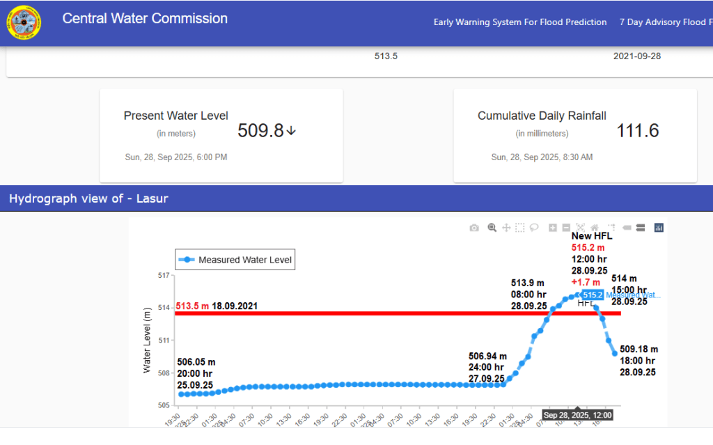
Maharashtra: Exactly after 4 years Shivna river in Godavari basin at Lasur site in Aurangabad district has crossed its HFL 513.5 meter dated 28.09.2021 at 08:00 hour on 28.09.2025. The flood level in the river increased by 7.86 meter in 10 hours from 506.94 meter at 24:00 hour on 27.09.2025 to 514.8 meter at 10:00 hour on 28.09.2025.
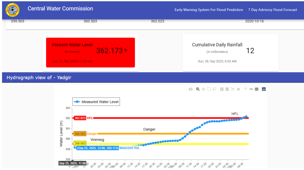
Bhima river at Yadgir site has crossed its HFL 362.023 meter dated 16.10.2020 at 09:00 hour on 28.09.2025. Present flood level is 362.173 meter at 10:00 hour with rising trend.
URBAN RIVERS
Hussain Sagar records higher pollution after Ganesh immersion Hussain Sagar lake’s water quality fell during Ganesh idol immersions this year, states a recent Pollution Control Board (PCB) report. Turbidity or cloudiness in the lake rose steeply while dissolved oxygen (DO) levels fell during the immersion season, reported Eenadu. The research was carried out after samples were collected on August 25, 30 and September 1, 3, 5 and 9 from six major immersion spots of Hyderabad’s Hussain Sagar: Buddha statue, Lepakshi Handicrafts, Lumbini Park, NTR Park Platforms 1 and 2, and Necklace Road.
The lake still sees the same tendency towards sudden spurts of pollution during immersions followed by slow recuperation. The research also supported that heavy metals such as chromium, copper, zinc, cadmium and lead presented no significant difference during immersion. According to environmental experts, while the lake recovers from submersion, the yearly stress on the lake due to idol immersion has long-term ecological implications.
RIVERS
Riverine heat waves on the rise, outpacing air heat waves Significance: -Riverine heat wave events—periods of abnormally high riverine water temperatures (WT)—can substantially impair aquatic ecosystems, water quality, and food and energy production. However, comprehensive analysis of riverine heat waves is still emerging, long hindered by fragmented and discontinuous WT data. Here, we used a deep learning model and reconstructed consistent daily WT in 1471 U.S. river sites (1980–2022). Results show that riverine heat wave events occur less frequently and intensively but last nearly twice as long as air heat waves. Alarmingly, riverine heat waves have risen at much faster rates than air heat waves. Results here underscore the need for coordinated monitoring and data consolidation efforts for riverine heat waves, and their incorporation into global climate risk assessment and adaptation policies.
Recent drying of Ganga is unprecedented in last 1,300 years -The findings underscore the urgent need to examine the interactions among the factors that control summer monsoon precipitation, including large−scale climate variability and anthropogenic forcings. Better constraints on these processes in climate models will be essential for improving future monsoon projections and implementing adaptive water management strategies to secure the Ganga basin’s freshwater availability under a changing climate.
Ganga Facing more droughts The Ganga River Basin experienced its most severe drying trend from 1991 to 2020 – the worst in the past 1,000 years, according to a new research, which examined 1,300 years of streamflow data and the increasing drought frequency amid an erratic monsoon. The study was led by researchers from IIT Gandhinagar who reconstructed the streamflow history from 700 to 2012 CE using the Monsoon Asia Drought Atlas, as well as ancient climate records and computer models. The analysis is published in peer-reviewed journal PNAS. The data revealed there have been more wet years than dry years during the last 1,300 years, but 1990 onwards, there were no extreme wet years in the Ganga river basin between 1991 and 2010, and only two extreme wet years between 2011 and 2020.
The findings raised grave concerns for water security, agriculture and power generation in one of the world’s most densely populated regions. What makes the findings more alarming is that most global climate models fail to capture this drying trend, with many projecting increased streamflow under warming scenarios due to expected rises in precipitation. Only a few models simulate the observed decline, raising doubts about the reliability of future water forecasts.
Some projections suggested that increasing rainfall under climate change could reverse the drying by 2040. However, researchers cautioned that without better management of human intervention, particularly groundwater exploitation, such a rebound may not materialise.
In fact, frequent droughts and low monsoons pulled down Ganga’s stream intensity so much in the last three decades that they impacted the average streamflow of the period between 1951 and 2020. Stretches of river that once supported year-round navigation are now impassable in summer. Large boats that once travelled the Ganges from Bengal and Bihar through Varanasi and Allahabad now run aground where water once flowed freely. Canals that used to irrigate fields for weeks longer a generation ago now dry up early. Even some wells that protected families for decades are yielding little more than a trickle.
Global climate models have failed to predict the severity of this drying, pointing to something deeply unsettling: human and environmental pressures are combining in ways we don’t yet understand. Water has been diverted into irrigation canals, groundwater has been pumped for agriculture, and industries have proliferated along the river’s banks. More than a thousand dams and barrages have radically altered the river itself. And as the world warms, the monsoon which feeds the Ganges has grown increasingly erratic. The result is a river system increasingly unable to replenish itself.
The need for urgent, coordinated action cannot be overstated. Piecemeal solutions will not be enough. It’s time for a comprehensive rethinking of how the river is managed. That will mean reducing unsustainable extraction of groundwater so supplies can recharge. It will mean environmental flow requirements to keep enough water in the river for people and ecosystems. And it will require improved climate models that integrate human pressures (irrigation and damming, for example) with monsoon variability to guide water policy.
YAMUNA Delhi DDA fails to learn flood lesson, to re-tile ghats Delhi seems not to have learnt its lesson despite repeated flooding of the Yamuna banks, experts said, as the Delhi Development Authority (DDA) on Sept. 26 said it plans to restart repair and maintenance work at Asita and Vasudev ghats of the Yamuna. Officials said repair works were necessary to restore public spaces, which attract visitors throughout the year.
The agency has planned to relay brickwork, concrete and fix signage at the ghats. DDA officials said they will be hiring a contractor for the works at Vasudev Ghat, where repair work has been estimated at ₹32.97 lakh, and at Asita Ghat, where repair is estimated at ₹46.7 lakh, in about two months.“The work will include cleaning of the area that was submerged and is covered in silt now, followed by brickwork, relaying interlocking tiles and installing signboards and stone structures to restore the flood-affected ghat,” a DDA official said.
Experts said that the recent inundation was not “flooding” but “river backflow” due to encroachment of its floodplains. Urban planning experts have pointed out that repeated relaying of brickwork and concrete structures on the floodplain could lead to a cycle of annual damage and repair. They warned that concretisation reduces the floodplain’s natural capacity to absorb excess water, forcing floodwater to rise higher during peak monsoon. This not only increases the risk of submergence but also adds recurring costs to the exchequer in the form of yearly restoration contracts.
Floods flush out pollutants The water quality of the Delhi stretch of the river Yamuna improved in September, as flood waters flush out pollutants, as per the Delhi Pollution Control Committee’s (DPCC) monthly report. The water quality improves almost every year during monsoon, as the extra water dilutes the pollutants, but the improvement does not last long, official data shows.
Life on the Edge of Yamuna In the national capital, the annual cycle of floods pushes the migrants living on the banks of the river deeper into instability.
Ghaziabad: Govt plans 40 cr riverfront Ghaziabad Development Authority (GDA) has proposed to develop a 1.5km riverfront along Hindon, from the City Forest to Raj Nagar Extension. The CM had years ago asked GDA to come up with a riverfront plan on the lines of Lucknow’s Gomti development. “The plan is in a nascent stage, but roughly 800m of riverfront on both sides of Hindon, from City Forest towards RNE, will be developed. The riverfront will be between the embankment and the outer ring road, which leads to the RNE township,” Rudresh Shukla, GDA’s media coordinator, said on Wednesday.
Shukla said the Authority will start with a request-a-proposal (RFP) and hire a consultant to come up with the detailed project report (DPR). “We expect that the project will cost about Rs 40 crore,” he said. Officials said they hope a riverfront will help accelerate efforts to clean up Hindon, which is normally described as a “dead” river because of its perennial black waters that are laden with industrial effluents and sewage.
SAND MINING
UP: 12 booked for killing man who objected to illegal sand mining Three sand miners and nine unidentified persons were charged on Sept. 25 for allegedly mowing down a 60-year-old farmer under the wheels of a tractor in Ashok Nagar village, under the jurisdiction of Hajara police station in Pilibhit. Indrajeet Singh was attacked around 8pm on Sept. 24 after he had allegedly objected to illegal sand mining on a village road where sand had accumulated after recent floods in the Sharda river. The accused include two media persons, Hemant Maheshwari of Sampurna Nagar and Arvind Yadav of Sidh Nagar village, who, officials said, had a nexus with the key miner, Alam Ali, whose address was not mentioned in the FIR.
Karnataka: Plea seeks action against illgal mining Accusing the district administration and the district Sand Monitoring Committee of failing to take any action against the Deputy Director of Mines and Geology and the Chittapur tahsildar for failure in stopping illegal sand mining at Bagodi in Chittapur taluk of Kalaburagi district, State Shiv Sena president Siddalinga Swami has said that he will approach the High Court of Karnataka seeking action against the district authorities and the Sand Monitoring Committee, if they fail to act against the officials. Addressing a press conference in Kalaburagi on September 25, Siddalinga Swami said that a team of officials from the Additional Director, Mines and Geology, Ballari inspected the sand mining site from May 16 to 18. The investigation revealed patterns of large-scale illegal extraction of sand.
WETLANDS, LAKES, WATER BODIES
Bihar: 2 more wetlands in Ramsar list The two new additions are Gokul Jalashay in Buxar district and Udaipur Jheel in West Champaran district, bringing the total number of such wetlands to five in Bihar. The number of Indian sites in the list has increased from 26 in 2012 to 93 in 2025, spread over 13,60,718 hectares, of which 51 wetlands have been added since 2020. Globally, there are 2,544 Ramsar sites. According to information on these two wetlands shared by India with the Convention secretariat, the Gokul Jalashay is an oxbow lake located on the southern edge of the river Ganga. Udaipur Jheel is also an oxbow lake which surrounds a village. The two wetlands have a total area of 448 hectares and 319 hectares, respectively, as per the MoEFCC.
Caste issues affecting Kabar Tal in Bihar Ram Sahani, a man in his sixties, sat on the parched earth by Kabartal Lake in Bihar’s Begusarai district, repairing a bamboo fishing trap. Dressed in a faded dhoti, he gazed at the shrinking waters before speaking. “Whatever you see submerged in water belongs to us, the fishing community. Whatever is dry goes to the farmers. Our ancestors fought in the freedom struggle and earned us water rights. Now, farmers are draining the lake using canals. If there is no water, we have no ownership over the lake or its resources. Farmers will plough it, and we’ll be left hungry, dependent on their mercy,” he says.
Bihar has a dense network of surface water sources. Major rivers such as the Ganges, Kosi, Gandak, and Son, along with their tributaries, create numerous chaurs (floodplain meadows) and mauns (oxbow lakes). Floodplains are flat areas that submerge when rivers flood, while oxbow lakes form when rivers change course. These interconnected water systems help maintain ecological balance during both floods and droughts. During floods, excess river water flows into the lakes and prevents nearby areas from being inundated. In times of drought, the lakes supply crucial water for survival.
Kabar Tal, also known as Kanwar Lake, is one such oxbow lake. It formed when the old Gandak River changed its course. Located about 145 kilometres from Patna, it was declared a bird sanctuary in 1989, covering 6,786 hectares. In 2020, it earned the status of a Ramsar site, marking it as a wetland of international importance. Protection must become the responsibility of the entire society — but society remains deeply divided along caste lines. Ignoring these divisions only deepens injustice. The real question is not whether Kabartal should be saved but how it should be saved. First, we must acknowledge that conservation, like land reform or economic policy, is never neutral. It benefits some and disadvantages others. Unless we address who gains and who loses from conservation efforts, we risk deepening the very inequalities that have created Kabartal’s crisis.
Punjab recommends 72 water bodies for notification The decision was taken during the third meeting of the Punjab State Wetlands Authority, which reviewed conservation initiatives in the state. The Supreme Court of India directed each state and UT wetland authority to complete ground-truthing and demarcation of the boundaries of all identified wetlands. In Punjab, following ground-truthing, digital mapping, and evaluation of 1,143 water bodies by district wetland committees, 72 water bodies were recommended for notification. These include sites in Amritsar (2), Barnala (8), Faridkot (2), Fatehgarh Sahib (12), Fazilka (8), Ferozepur (3), Jalandhar (2), Kapurthala (4), Mansa (10), Moga (6), Patiala (3), Sangrur (5), and Muktsar (7).
The authority also approved an integrated management plan (IMP) for the Beas river, with a five-year budget requirement of Rs 38.45 crore for various works. The approved plan will now be sent to the MoEF&CC for funding under the National Plan for Conservation of Aquatic Ecosystems (NPCA).
Goa: HC told GCZMA to restore Marna-Siolim mangrove The High Court has been told that land in Marna-Siolim, where six cottages and a restaurant now stand, was once a natural lagoon connected to the river and part of a sprawling mangrove wetland. In an affidavit, former National Institute of Oceanography (NIO) scientist Dr Antonio Mascaren has said the plots bearing survey numbers 318/2, 319/2 and 320/2 were originally a saline water body surrounded by marshes and mangroves. He noted that the Regional Plan 2021 had marked the area as a “fish farm”. The affidavit was filed on the Court’s direction while hearing a miscellaneous civil application by Marilyn Agasta Sabrina Judith Soares e Fernandes Gov EIA.
WATER OPTIONS
Bidar bags national award for water conservation efforts In a landmark achievement, Bidar district has been honoured with the prestigious Jal Sanchay Jan Bhagidari Award under the Jal Shakti Abhiyan: Catch the Rain campaign. The district will receive a cash prize of Rs 25 lakh from the Union govt, in recognition of its exemplary contributions to water conservation and community participation in sustainable water management. Highlighting the district’s key interventions, Zilla panchayat CEO Girish Badole noted that storage structures like small check dams, gabion structures, gully plugs, percolation ponds, ponds, lakes, and waterbodies (used for groundwater recharge or storage), soak pits were constructed, and rejuvenation of traditional rainwater harvesting and recharge systems such as tanks, stepwells, lakes, etc. were completed.
Telangana ranks first in rainwater harvesting Telangana has secured the top position in the Jal Sanchai Jan Bhagidari (JSJB) 1.0 rankings announced by the Union Ministry of Jal Shakti, emerging as the best-performing State in rainwater conservation. Chhattisgarh and Rajasthan secured the second and third positions respectively. During 2024-25, Telangana undertook 5,20,362 rainwater harvesting works, the highest in the country. The works included construction of check dams, soak pits, rooftop rainwater harvesting structures, borewell recharge, sub-surface dykes, farm ponds and percolation tanks.
Raipur ranks 2nd in water conservation campaign The Raipur Municipal Corporation has won the first prize for its outstanding contribution through 33,082 water conservation works, in the urban bodies category, the official said. So far, 4,05,563 water conservation projects have been completed across the state, turning the initiative into a mass movement.
Karnataka exploring Shirapur model rainwater harvesting project The govt is considering implementing the Shirapur Model of water conservation in Kalyana Karnataka districts to enhance groundwater levels and improve water availability, Minister for Minor Irrigation, Science and Technology N S Boseraju announced. The Shirapur Model relies on rainwater harvesting and groundwater recharge through scientific development of streams and construction of check dams. The project curbs runoff, boosts groundwater levels, and ensures long-term water sustainability.
Himachal: Pradeep Sangwan’s Chandratal cleanup finds 159kg of liquor bottles at 14,000 ft
GROUNDWATER
Study finds high lead & uranium levels in kids in Punjab & Chandigarh A pilot study found high levels of lead and uranium in the blood of children and in groundwater samples from Bathinda, Ropar and Chandigarh, posing a grave public health crisis. The study, carried out by Panjab University’s Geo-Environmental Research Laboratory in collaboration with Baba Farid NGO among children in the age group of 5-15 years, analysed 149 blood samples, 137 hair samples, and 37 groundwater samples. The results showed contamination well above international safety norms in many cases.
Alarmed, the human rights commission directed the chief secretaries of Punjab and Chandigarh to submit a survey plan, focusing on children and pregnant women, and identifying contamination hotspots. It ordered toxicology departments to be set up in at least one govt hospital each in Punjab and Chandigarh and RO-water purification systems in all schools. Authorities have been directed to file compliance and action reports by Dec 5.
MP govt ignores GW tests after UCC clean-up Environmentalists have raised concerns over the indifferent attitude of state agencies for not testing groundwater quality following the cleanup. In January 2025, 350 MT chemical waste from UCC plant was transported to Pithampur for incineration. Dr SC Pandey, environmentalist, said, “Before cleanup, multiple groundwater tests were conducted around plant site to assess water quality. It is pathetic that government is now uninterested in any tests that could build confidence and ease panic among gas tragedy survivors living nearby. This monsoon is the first after cleanup, so government should act in interest of survivors.”
Tamil farmers flag reduced subsidy to build underground water tanks Farmers are aggrieved as the subsidy for constructing underground water tank has been reduced from Rs 350 per cubic metre to Rs 125. “To overcome this, the Supplementary Water Management Activities (SWMA) project has been providing subsidies for constructing underground water tanks, which are used to store water for drip irrigation. It costs a maximum of Rs 40,000 to build a tank, Rs 10,000 to lay pipes and Rs 15,000 to install a pump set. Many farmers showed interest in this project and benefited from it. Meanwhile, this subsidy was reduced and now, Rs 125 per cubic metre is provided to construct a tank with clay or polythene sheet under the National Horticulture Mission,” he added. “If a farmer constructs a cement tank, it costs around Rs 1,000 per cubic metre, totaling Rs 4 lakh for a tank with 1.14 lakh litre capacity. The government provided subsidy of Rs 350 earlier, which was useful. But the current subsidy is very less,” he said.
URBAN LAKES, WETLANDS
Chennai: Eco-restoration alone won’t help Manali-Ennore region In Ennore and Manali, decades of industrial pollution have translated into daily health struggles — from asthma and respiratory infections to cancer and fertility issues. While the State has announced restoration projects, residents say these efforts ring hollow without parallel interventions to address the growing public health crisis.
URBAN WATER
CGWB investigates Bhubaneswar realtor for forging documents A realtor of a prominent housing society in Paikarapur, Kalinga Nagar, has been show-caused by the Central Ground Water Board (CGWB) for allegedly forging documents in the name of the allottee’s association to make payment for the groundwater used in the apartment. The realtor was originally show-caused by the CGWB for the first time in April last year for not obtaining a no-objection certificate for using the groundwater in the apartment. The realtor was then issued a demand notice of Rs 3.5 crore and was asked to make payment for using the groundwater in the apartment from Sept 2020 to May 2024.
In the meantime, the developer allegedly forged the document in the name of the housing society to lower the penalty. Accordingly, it formed a duplicate association and applied for the NOC from the CGWB. The CGWB then issued the NOC in the name of the association and asked for payment of Rs 38 lakh. Currently, the developer, after making the Rs 38 lakh payment for extracting groundwater in the project, is reportedly asking the allottees to pay back.
Trichy: Protest over water contamination in Manapparai Residents of a street in Manapparai complained about contamination of their drinking water supply on Sept. 25, prompting municipality officials to hold an inspection. They found that sewage from one of the houses was mixing with the water.
AGRICULTURE
Solar Farms vs Rainfed Agriculture in Koppal-Karnataka The Rain-fed farming has traditionally escaped policy and funding attention, though it engages more than 60% of India’s farmers. In Karnataka’s Koppal, it now finds itself competing with state-backed solar farms for real estate, at a considerable social cost. The land wasn’t barren. Koppal district alone contributes 10.30% to state paddy production and is considered the rice bowl of Karnataka, although 76% of the cultivated land is dependent on rain and is drought prone. The rapidly expanding solar energy industry is now leveraging the uncertainty of the monsoon. In the race to develop renewable energy (RE) and meet the state’s RE targets, vast tracts of rain-fed agricultural lands are being leased or acquired by solar park developers.
The burden of the transition to renewable energy, however, is being shifted onto the backs of rain-fed farmers, who have already borne the brunt of climate impacts and policy neglect, and for whom the state’s role must go beyond simply enabling solar leases. Farmers are pushed out of agriculture not by choice but due to neglect.
MONSOON 2025
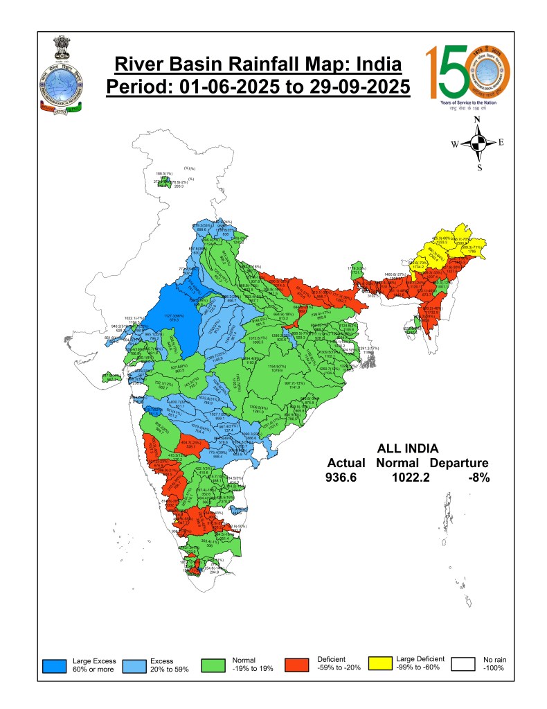
Monsoon withdraws completely from northwest India The southwest monsoon has withdrawn completely from northwest India, leaving behind unprecedented inflows in crucial dams and causing devastating floods across the region this year. According to the India Meteorological Department (IMD), the monsoon withdrew from the entire Western Himalayan region, including Jammu and Kashmir, Ladakh, Himachal Pradesh and Uttarakhand, on September 26. The withdrawal line now passes through Veraval, Bharuch, Ujjain, Jhansi and Shahjahanpur.
Punjab recorded a cumulative rain of 621.4 mm from June 1 till September 26, a surplus of 42 per cent against the long-period average (LPA) of 436.4 mm. Haryana saw 568.4 mm of rain during this period, 34 per cent above its LPA of 424.1 mm. Himachal Pradesh received 1,022.8 mm of rain, 40 per cent above its LPA of 729.5 mm. However, in 2024, the monsoon was deficient by 28 per cent in Punjab, five per cent in Haryana, and 18 per cent in Himachal Pradesh, according to IMD data.
URBAN FLOODS
Buried drains: The cost of makeovers When the DDA set out between 2009 and 2013 to cover stretches of the Kushak Drain in Defence Colony, it presented an alluring picture. Now, every time these drains need to be cleaned, structures on top have to be ripped apart for agencies to have access to the drain underneath.
The Delhi government’s Irrigation and Flood Control Department (I&FC) said it lacks the equipment; the New Delhi Municipal Council (NDMC) tried robotic cleaning with limited success; the fire department has been asked to pressure-clean blockages; and now, in a surreal twist, the Delhi Metro Rail Corporation (DMRC) has been tasked with a ₹34 crore project to unclog the Kushak drain — even though it has no prior experience in such work.
The problem, experts said, mirrors Delhi’s larger approach to the Yamuna itself: addressing symptoms rather than sources. “Earlier, people drew drinking water downstream of Najafgarh,” says Bhim Singh Rawat of the South Asia Network on Dams, Rivers and People (SANDRP). “When jaundice broke out, instead of tackling Najafgarh’s contaminants, Delhi built the Wazirabad barrage. We repeat this mistake with drains — concretising, covering, adding metro pillars and roads — without tackling sewage inflows.”
Rawat warns that drains are not nuisances but tributaries of the Yamuna. “Five or six of the larger drains once carried clean water year-round. Covering them has disrupted flows, increased pollution, and harmed the river. The only long-term solution is daylighting: uncovering and ecologically restoring them.” Urban planners say the time for cosmetic fixes is over. Rawat agrees: “This teaches us a lesson — no drain should ever be covered again. Treat them as part of the Yamuna’s ecosystem, not as urban eyesores. Don’t tackle symptoms but find solutions to underlying problems.”
Govt to build ‘Silt Traps’ along drains The Delhi government has unveiled a Drainage Master Plan that proposes the construction of ‘silt traps’ along major drains to prevent waterlogging. The initiative, aimed at modernising the city’s outdated drainage infrastructure, is inspired from a successful pilot project in Chennai.
Designed to meet the city’s drainage requirements over the next 30 years, the master plan will be implemented in five years in two phases. The method aims to reduce waterlogging episodes by 50 per cent in the next three years and flood-related accidents by 30 per cent in the next five years. The two phases will involve critical flood control and network expansion with priority integration, overhauling the drainage network that runs up to 18,958 km and is overseen by eight agencies.
Drainage Master Plan 2025 On September 19, Union Minister for Housing and Urban Affairs Manohar Lal unveiled a Rs 57,000 crore Delhi Drainage Master Plan 2025, a 30-year solution for urban flooding that aims to reduce instances of waterlogging and flooding by 50% in the next five years.
Govt aims to curb flooding next monsoon Taking note of the waterlogging and flooding witnessed in parts of the capital during this year’s monsoon, the Delhi government has directed district magistrates to prepare comprehensive reports on impacted areas, officials said on Sept. 25. The reports will not only identify specific locations that faced flooding but will also analyse the underlying causes, recurring problem areas, and the agencies responsible for each case, they added. The initiative aims to build a district-wise database of vulnerable locations and identify shortcomings in the existing infrastructure, an official noted.
HIMALAYAN DISASTERS
Deluge & Disaster Floods Unstoppable rains. Cloudbursts. Landslides. Millions worth of livelihoods and property lost to the surging waters and collapsing hills. What is behind this demonstration of Nature’s fury in northern India – climate change, human actions, or both? (This webinar also features Himanshu Thakkar, Coordinator, SANDRP)
Green seeks review of 2021 SC ruling on Char Dham road project In a renewed appeal to Chief Justice of India B. R. Gavai, former union ministers Karan Singh and Murli Manohar Joshi, along with several other signatories, wrote to the Supreme Court on Sept. 26 urging it to reconsider its 2021 ruling on the Char Dham project. They alleged that permitting the widening of roads to 12 metres has triggered widespread landslides and sinking zones in the ecologically fragile region. They urged the SC to quash the MoRTH circular and review the 2021 judgment, which validated the double-lane road width for feeder highways in hilly border areas. A double-lane road justified on defence grounds, the petitioners argued, “would wreak avoidable damage in this extremely fragile stretch, which is already experiencing unprecedented events this year.”
Hundreds protest against elevated highway in Dehradun Hundreds march in Doon against proposed Rs 6.2k cr Bindal-Rispana elevated corridor.
Dharali disaster: Missing declared dead after 51 Days Fifty-one days after devastating flash floods swept through the region on 5 August, 67 people remain unaccounted for. The state government had urgently petitioned the Centre to relax the standard legal norms to provide closure and timely aid to affected families. According to official sources, the approval, issued by the Registrar General of India under the Home Ministry, bypasses the standard provisions of the Registration of Births and Deaths Act, 1969, which typically requires a seven-year waiting period before a missing person can be legally declared deceased. This move mirrors a similar exemption granted by the Centre following the 2021 Chamoli disaster, where hundreds of workers were swept away in the Rishi Ganga tragedy.
SC to Himachal on Disaster Management Measures The Supreme Court on Sept 23, 2025 asked the Himachal Pradesh government to come completely clean on its plans for disaster management, its climate change and tourism policies, constructions and industrialisation, details of mega hydroelectric projects, four-lane highways and even the number of trees felled and prosecutions pending district-wise over the years. A Bench led by Justice Vikram Nath, in a suo motu case, quoted the Supreme Court’s observation that “humans, not nature, are responsible for the phenomenon such as continuous landslides, collapsing of houses and buildings, subsidence of roads, etc,” against the backdrop of landslides and flash floods which have wrecked the State during the monsoon.
The court has recorded a series of 44 questions prepared for the State government by its amicus curiae, senior advocate K. Parameshwar, including “whether zoning (if any) is done on the basis of seismic activity/ landslides/ green cover/ eco-sensitivity”. The court has sought if the State has any ecological sites which prohibit industrialisation/ bringing up of mega projects. The Bench has sought details of desisgnated protected areas/ reserved forests/ wildlife sanctuaries/ national parks and eco-sensitive sites in the State and whether the eco-sensitive zones have been notified across the protected areas. It has sought details of the total designated forest area in Himachal Pradesh and how much of the forest area has been diverted for non-forest use in the last two decades.
“What percentage of tree cover and forest cover have changed across the State over the last two decades? The district-wise details over the last ten years are to be placed on record. Has the State conducted any tree survey and/or forest surveys and/or any other study to analyse the changes, if any, in the green cover in the State?” the order has queried. It has also sought statistics of the permissions issued to private entities or public sector undertakings for felling 500 or more trees in bulk. Statistics for the last 10 years has to be provided along with the details of cases/ prosecutions pending.
“Details of disaster management plans prepared by the State and steps that have been taken for implementation thereof… Details of funds allocated for disaster management in the State for the last 20 years and the details of utilisation thereof, to be placed on record. Details of projects, if any, with the stage thereof undertaken by the State Disaster Mitigation Fund. Details of State Highways and National Highways in the State of Himachal Pradesh with specific details on the number of highways which are four-lane. Details of upcoming/ proposed highways (State/National) and their stages of completion,” the order has asked. The court has sought the details to be placed on record before the next hearing on Oct 28. The order passed on Tuesday stressed that the responses from the state on the 44 questions are essential to frame guidelines which the court proposes to deal with on the next date of hearing.
GLACIERS
GLOF Risk monitoring network Study ABSTRACT: There are a substantial number of glacial lakes in the Himalaya with potential transboundary GLOF impacts, and their remote high-altitude locations make monitoring extremely challenging, so existing field measurements are limited. This paper proposes a benchmark Himalayan glacial lake monitoring network ‘HiGLMN’ that will characterize glacial lakes by combining geomorphological signatures of GLOFs, monitoring triggers and mechanisms of dam failure and downstream impacts using in-situ observations, remote sensing, and hydrodynamic modelling, and feed into early warning for disaster mitigation. It also provides existing practices to support the effectiveness and necessity and propose strategies for future data management.
SANDRP
