“When Jahlma Nallah starts roaring, we cannot sleep. It has been flooding for the past three years at least” said octogenarian Devi Singhji in October 2024. Jahlma Nallah, which joins the Chenab and blocks it occasionally, flooded again catastrophically in the monsoon of 2025.
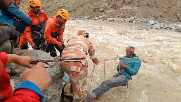
Monsoon of 2025 has been relentless in the Indian Himalayas of Jammu and Kashmir, Himachal Pradesh and Uttarakhand. At least 310 deaths are reported by the State Disaster Management Agency, Himachal Pradesh[1] in rain-related incidents. At least 10 deaths have been reported from Chamba and Manimahesh Yatra. In Jammu and Kashmir, more than 100 deaths have been reported from Chasoti and Vaishno Devi pilgrimages. There are additional deaths from landslides in Ramban in April and August 2025. Dharali, Yamuna and Chardham Yatra disasters have claimed more than 100 lives in Uttarakhand. Even as I write, IMD has forecasted heavy rainfall in September in Uttarakhand and Himachal. The situation is dire and may continue to remain so for a while.
While rainfall, river flooding, and landslides are central to this tragedy, streams or Nallahs play a critical role in intensifying the disasters. Nallahs/ streams are placed somewhere between a river and a tributary. Many Himalayan nallahs are glacier-fed. Examples include the Pagal Nallah, Jahlma Nallah, or Karpat Nallah in Himachal Pradesh. There is also Chasoti Nallah in Jammu (Chasoti Disaster) and Kheerganga Rivulet in Uttarakhand (Dharali disaster). There are geological, climate-related, ecological and social reasons for nallahs having played a significant destructive role in this disaster. There is a need to urgently identify and address vulnerable nallahs.
While being the lifelines of the mountains, nallahs can also bring together disasters in the whole watershed. Water, snow, debris, trees, boulders etc., accumulate in the nallah. They flow downstream, creating a positive feedback loop. This process causes further erosion and gains destructive power. Glacial Lake Outburst Floods and avalanches also roar downstream through nallahs. Their proximity to settlements and their docile nature during dry season makes them particularly dangerous in the monsoons. Several nallahs in the Himalayas are called “Pagal” (Mad one), Bhut (ghost/spirit), some are even “Khooni” (A killer) for a reason.
- River mainstems in the Himalayan hills flow through deeper valleys. Nallahs or rivulets flow right through towns and villages. They go past homes, shops, and schools.
- Several nallahs in places like Bhuntar, Shimla, Kullu and Mandi are severely encroached upon, constricted by construction, their courses changed.
- “Muhana” or the mouth/confluence of a nallah with a bigger stream forms small, fertile, and relatively flat valleys. Villages, towns, and farms are often situated in these areas. This is a particularly dangerous place. During flashfloods, massive amounts of debris and silt are deposited here. Examples include the confluences at Dharali (Uttarakhand), Chasoti (Jammu), Lippa (Kinnaur), Pagal Nallah (Lahaul and Spiti), Karpat Nallah (Miyar Valley), Dhanchho Nallah (Manimahesh), etc.


Nallah crossings are most frequent places of road blockages, accidents and destruction.
- When debris-laden, flooded nallahs meet rivers, they can result in a landslide on the opposite bank of the river. This situation was observed in Jahlma and Shanshan Nallahs and Chenab River. A similar occurrence happened at Ribba Nallah and Sutlej River. Confluence scour is the erosion of the riverbed. This erosion is caused by the force of heavily flooded nallahs. It can lead to temporary dams and bank failures.
- Significantly, many nallahs where severe destruction occurred or is occurring now were flagged as dangerous. Local communities, scientists, or local administrators identified these areas. They have experienced floods and mishaps several times in the past.
A long-term, site-specific strategy is urgently needed to understand and respond to the current disaster. It is also crucial to identify, monitor, and highlight streams, nallahs, and glacial lakes. Specific vulnerable places where tragedies have been recurring must be addressed. Work at these places needs to be undertaken without losing any time, or lives.
Based on field visits, interviews with residents and local officials, and scientific studies, we have created a preliminary list. It includes such nallahs in the Chenab basin in Himachal and Jammu and Kashmir. A few nallahs from the Beas and Sutlej Basins are also included.
This is a limited list and needs to be expanded with local and expert participation.

See on Google Earth: https://earth.google.com/earth/d/1HYPGq4xj3ocJTl-E_MbASDaEg7YqLc9z?usp=sharing
Vulnerable Nallahs in the Chenab Basin with some from Beas and Sutlej
| Nos. | Name | Location | Basin | Past and present disasters | Available studies | Imminent threats |
| 1 | Pagal Nallah | QC55+9W, Dhar Umnag, Himachal Pradesh 175132, India | Bhaga River, Chenab | Landslides, Zingzing bar, Repeated flash floods and erosion | Media Reports, Communication with locals and local authorities | Adjacent to Leh-Manali Highway, Proposed 300 MW Jispa Hydropower project |
| 2. | Teling Nalla | 32.449733, 77.155697 Teling, Lahaul | Chandra River, Chenab | Repeated Flashfloods, Erosion, threat to lives | Media Reports, communication with villagers and MLAs | Teling and Sissu villages, significant number of tourists travelling on Manali-Leh Highway |
| 3 | Jahlma Nallah | Bridge: JVQ9+24P, SH 26, Jahalman, Himachal Pradesh 175139, India Lindur: JVXG+3HJ, Lindur, Himachal Pradesh 175139, India | Chandrabhaga, Chenab | Repeated Flashfloods, Erosion, Landslides, Mudslides, Land subsidence, Melting permafrost | IIT Mandi, GSI, Studies, Media Reports, SANDRP | Lindur village, Jasrath village, Jobrang village Proposed Rashil and Bardang Hydropower Projects |
| 4 | Shansa Nallah | 32.631344, 76.866419 | Chandrabhaga, Chenab | Repeated floods, Landslides, Erosion, Crop loss | Local farmers, SANDRP | Jasrath, Jahalman, Nalda, Jobrang villages |
| 5 | Thirot Nallah | 32.662229, 76.781195 Thirot, Lahaul and Spiti | Chandrabhaga, Chenab | Dharali-like geography, Flash floods, landslides, Blocking main river | Local MLA, Farmers, studies | Nainghar, Chowkham, Thirot villages, Tandi-Kishtwar Highway, 4.5 MW Thirot Hydropower Project by HPSEBL |
| 6 | Samudra Tapu Glacial Lake | FGXW+CFM, Himachal Pradesh 175140, India | Chandra, Chenab | Glacial Lake growing at an alarming rate posing a GLOF Risk | ISRO Studies, SANDRP | Batal, Chhatru, Chandra Valley, NH 505 Gramphu-Batal Kaza Road |
| 7 | Ghepan Gath Glacial Lake | Sissu, Himachal Pradesh 175140, India | Chandra, Chenab | Glacial Lake growing at an alarming rate posing a GLOF Risk | Studies including NRSC, ISRO, SANDRP | Sissu and villages in the downstream including Tandi Proposed Hydropower projects on Chenab |
| 8 | Karpat Nalla | RPGW+9WG, Miyar Valley Rd, Karpat, Himachal Pradesh 175142, India | Miyar valley, Chenab | Repeated flashfloods, Landslides, Boulders coming loose, Repeated relocation of villages | Local Authorities, MLA, Media reports | Karpat, Chamrat, Ghari villages. Udaipur town, Proposed 120 MW Miyar Hydropower Project |
| 9 | Kadu Nalla | VC4V+G2C, D.P.F.Kadunalah, Himachal Pradesh 176323, India | Pangi Valley, Chenab | Glacial Lake growing at an alarming rate posing a GLOF Risk | Studies | Shour Village, Tandi-Kishtwar Highway, 5 MW Tunthiaru, 5 MW Karu, 5 MW Ajog, 232 MW Purthi HEP |
| 10 | Bhot/ Bhut Nalla | 33.281183, 76.176774 | Paddar Valley, Chenab, Jammu | Repeated Flashfloods, disasters, Deaths, Chasoti disaster | Personal Communication, Media reports | Several villages including Chasoti, Gulabgarh Town, Tandi-Kishtwar Highway |
| 11 | Hangu Lake | 33°18’45″N 76°21’43″E | Paddar Valley, Chenab, Jammu | Highlighted as “Highly dangerous lake” | Studies | Kabban, Sohal villages, Tandi-Kishtwar Highway |
| 12 | Mundiksar Lake. Mouth of Tanak Glacier | 33° 52.230′ N 76° 7.072′ E | Kishtwar High Altitude National Park | Highlighted as “Highly Dangerous Lake” | Studies | 800 Bursar and 1000 MW Pakal Dul Hydropower projects` |
| 13 | Khooni Nalla | 33.31676653822316, 75.1935912655701 Doda, Jammu | Chenab, Jammu | Ramban Floods April 2025 April 2024 | Social Media, Media Reports | |
| 14 | Kalnai Nalla | 33.143365, 75.800089 Doda, Jammu | Chenab, Jammu | Devastating flash floods, HFL crossed 2025 | Media reports | Several densely populated towns, Proposed Lower Lower Kalnai Power project which was damaged in 2018 |
| 15 | Neru Nalla | 33.138182, 75.558545 Doda, Jammu | Chenab, Jammu | Flashfloods and Erosion, HFL crossed 2025 | Media Reports | |
| 16 | Ribba Nalla | 31.585159, 78.372212 Ribba, Kinnaur, Himachal Pradesh | Satluj River, Kinnaur, Himachal | Flashfloods, erosion and landslides due to confluence effect | Personal Communication | 6 kms from Tidong Hydropower Project, Farms and villages |
| 17 | Entire Beas mainstem | Palchan, Kullu, Manali, Mandi | Studies, Media Reports, Personal Communication | Densely populated towns and tourist infrastructure |
Medium & Long Term interventions
Data collection It is imperative to understand the nature of the past tragedies and make relevant plans. It is unthinkable that after repeated tragedies, there are no rain gauges, flood gauges or alarm systems for these sites. Dr. Roxy Matthew Koll, Climate Scientist at Indian Institute of Tropical Meteorology tells SANDRP, “In addition to a gap-filling X band Doppler, practical package for the vulnerable nallahs would be a dense automatic rain-gauge network (hourly/5-min data) with telemetry along with river-water-level sensors plus cameras and community sirens at hot spots.”
- Automated Flood Alert System linked to Disaster Management Authorities and local institutes like schools, marketplaces, gram panchayats etc.
- Inventory of historic extreme weather events like flashfloods, cloudbursts, landslides, mudslips, dam failures etc.,
- Inventory of places that suffered maximum damage (for eg. Confluences/ nallah mouths, etc)
Immediate rehabilitation options
- SOP for immediate resettlement of population in case of alarm. Rehabilitation sites marked, tents, boats, medical emergency equipment deployed.
- All this information clearly available and displayed in local language in schools, through anganwadi workers and gram panchayat meetings repeatedly.
Intermediate disaster prevention
- Lowering the water levels of dangerous glacial lakes.
- Urgent site-specific study of vulnerable nallahs and river stretches to identify safe zoning for settlements. Width of this safe zone can vary for different nallahs.
- Strict implementation of zoning along Nallah banks/lake or river banks . No impediment to flow in terms of dams or other infrastructure. No change in the course of the stream or river through channelization bringing false sense of security.
- Any major interventions in such areas to be decided after independent studies and consent from the local communities.
Long term scientific studies
- Studies to understand the reasons behind repeated tragedies. They might be very different from place to place. For example MLA Anuradha Rana from Lahaul and Spiti told SANDRP, “Pagla Nalla in Darcha floods after rain, while Jahlma Nalla in Lindur floods after intense sun and heat”. Understanding the mechanisms that trigger such events is crucial to develop a workable strategy
Heed Warnings
In most of these streams/nallas, there exist robust scientific studies that have repeatedly highlighted how dangerous these places are. These should be looked at seriously. The scientists and scientific bodies too need to communicate their findings with the decision makers and policy makers.
Communities have highlighted vulnerability of these places through repeated follow ups with authorities, letters, complaints etc. Now, even the priests of the local gods are talking about regulating and safeguarding these places. Local farmers, teachers, pastoralists, women have a wealth of information about their landscape and the way it is changing. These insights need to form the foundation of any adaptation mechanism.
These are some basic steps to be taken for the highlighted vulnerable streams/ places. Such lists need to be strengthened and built further with the help of stakeholders from the ground to the scientific community.
Parineeta Dandekar, SANDRP (parineeta.dandekar@gmail.com)


[1] https://www.thehindu.com/news/national/india-rain-telangana-kerala-andhra-tamil-nadu-karnataka-jammu-and-kashmir-himachal-flood-august-28-2025/article69983152.ece#:~:text=“The%20ongoing%20monsoon%20season%20in,accidents%2C”%20according%20to%20the%20State
