The current developments around Indus Waters Treaty are deeply troubling. Following the heinous attack on tourists in Pehelgam, India has announced that Indus Waters Treaty, the only water sharing mechanism between India and Pakistan put in place in 1960, has been put in abeyance.
While this announcement implies several things that India can do, one of the ‘tools’ being highlighted is more infrastructure (read Dams) on these rivers as soon as possible[i]. Pakistan has stated that suspending IWT is an ‘Act of War’.
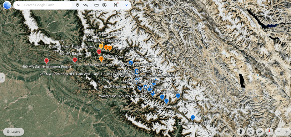
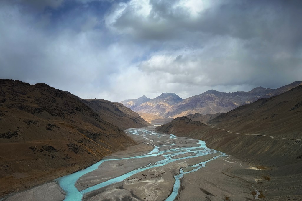
But there is already a war going on in the Indus basin right now that has claimed hundreds of lives on both sides of the border (3 people, just four days back[ii]), has driven people destitute and homeless, affected crops and livelihoods. That war is in the form of Climate Change, repeating disasters and the massive changes in hydrology in Indus basin in general and Chenab Basin in particular. Chenab Basin has the largest number of completed, under-construction and planned hydropower projects among the Western Rivers of the Indus basin in India and is therefore significant.
Any hasty plans to push further dams, completing construction of ongoing projects in a rush, bypassing important studies and safeguards around dams, ignoring local protests which are fueled by repeated disasters, is extremely dangerous in this region.
We will briefly look at Climate Change and related disasters, Water Security, Hydropower development, governance around these issues and whether it is feasible, desirable or advisable to push for more dams in this region.
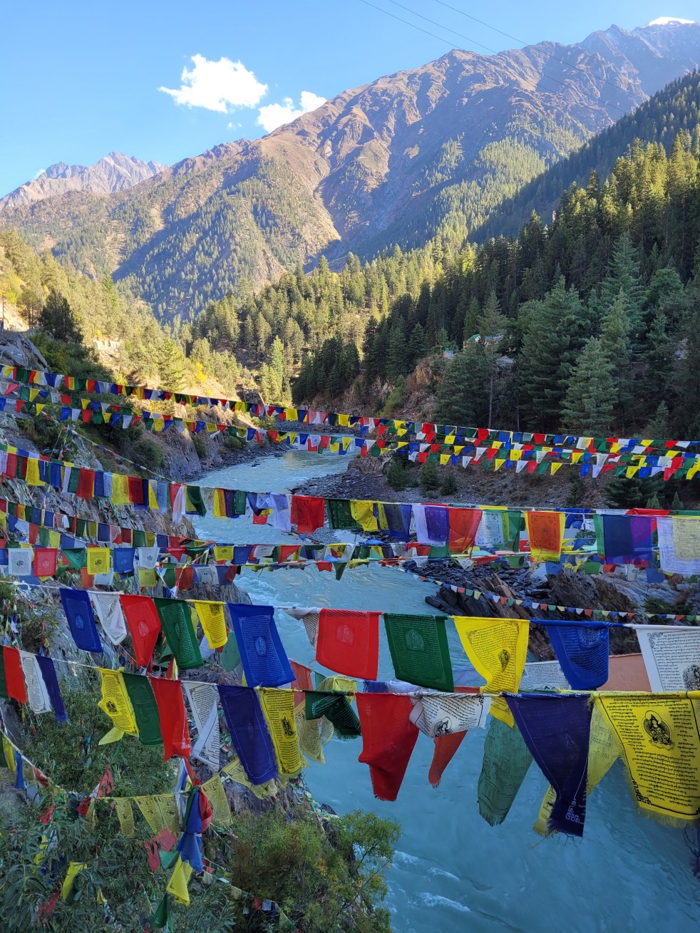
The report is based on extensive travel and fieldwork (October and Nov 2024) from origin of Chenab to Akhnoor where the river exits India, community interviews, review of government reports and scientific studies in the Chenab Basin.
- Glaciers in the Headwaters of Chenab Basin
Chenab forms at the confluence of Chandra and Bhaga rivers in Lahaul and Spiti, Himachal Pradesh. According to the Indus Waters Treaty, Chenab is a Western River, allocated to Pakistan. India is permitted limited consumptive use and unlimited non-consumptive use of Chenab. Between the period IWT was signed to 2004-5, studies estimate that glacial volume in Chenab basin is reduced by a whopping 33.3% [iii] For a river whose flows are made up of 50% meltwater when it leaves India at Akhnoor, this is shocking for both India and Pakistan. Glaciers, the water stored in them, the slow release of this water in spring and summers is the key to water security of entire Himalayan region. 60% irrigation in entire Indus basin depends on glacial melt[iv]. As the glaciers are concentrated in Indian Himalayas, their health and sustenance is crucial for millions in both countries.
Let us look at both these rivers Chandra and Bhaga, which originate at around 15900 feet at Baralachala pass in the Greater Himalayas and especially glaciers and hydropower in these basins.
- Bhaga Basin
Bhaga River originates near Surajtal lake. The region is home to over 306 glaciers (each with area larger than 200 sq mts), all of which are rapidly retreating. The total stored water of Bhaga Basin glaciers is estimated at approximately 15 Billion Tons.[v]
Not only has the total area covered by glaciers reduced between 1971 to 2020 but the rate of deglaciation “has increased significantly (0.25 % yr-1) compared to the previous decades.”[vi] Rate of change of glacier area has doubled in the last two decades.[vii] Temperature shows an increasing trend of about 1.14° Celsius between 1961 and 2015 and significant precipitation decrease from 1990s onwards which “have probably augmented ice loss in the Bhaga basin during the early 21st century.”[viii] Glaciers have undergone significant amount of mass loss and thinning.[ix] And scientists fear “At this rate of retreat, small glaciers (area less than 1 km2) will permanently disappear soon.”[x]
In 2018 a GLOF event occurred near Zingzingbar. The region routinely faces debilitating floods and landslides.
The massive 300 MW Gyspa Hydropower project is proposed at Gyspa village in Bhaga basin. It envisages a gross storage of 0.74 Million Acre Feet through a dam that will submerge 1260 hectares land and 4 villages including Darcha. Local population, especially women, have put up strong opposition to this project and one of the main reasons for doing so is increasing disasters in the region.[xi]
b. Chandra Basin:
Chandra basin occupies an area of 2,440 sq km area and has around 200 glaciers and 23 small villages.[xii] It is home to some of the largest glaciers in Himachal Pradesh like Bara Shigri, Ghepan Gath and Samudra Tapu, all of which show alarming climate change impacts.
Even in moderate emission mitigation scenario, the basin is projected to lose 33% of its ice volume by 2050s. That is a loss of 17.7 Billion Tons of Ice.[xiii]
Studies predict that “In response to the projected climate, the basin is likely to retain only ~ 50% (In moderate mitigation scenario[xiv]) and ~40% (in business-as-usual scenario[xv]) area of glaciers by the end of the century.
Corresponding volumes of glacier water retained are much lower at~ 40% and ~30% but the volume loss could be as high as 97% for low altitude glaciers.”[xvi]
From 2000 to 2014, the total number of glacial lakes in Chandra basin (larger than 2000 sq mts) increased from 28 to 46 and their area expanded from 1.91 sq km to 3.26 sq km. The accelerated growth of glacial lakes has resulted in increased hazard and damage potential of glacial lake outburst floods.[xvii] And “Glacial Lake Outburst Flood (GLOF) is an emerging threat in the Chandra basin.’[xviii]
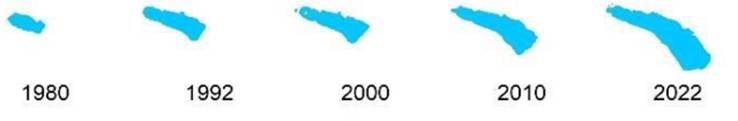
Samudra Tapu Glacier and Glacial Lake
- India’s premier remote sensing institute National Remote Sensing Centre (NRSC) under the aegis of Indian Space Research Organization (ISRO) in its 2024 report on Samudra Tapu Glacial Lake states[xix], “A change analysis of the lake water spread area carried out in 1965 and 2022 satellite imagery revealed a 905% increase in size from 14.19 ha to 142.69 ha. Such alarming rate of lake expansion and growth of its downstream settlements have increased the possibilities of a catastrophic impact due to GLOF event by many folds.”
- The estimated discharge at 100% breach of the lake is 17,342 cumecs (cubic Meters per second) and will affect settlements far and wide along the Chenab.
- Studies also show that such a GLOF will be a threat to life and property to villages downstream like Chhatru[xx] where 126 MW Chhatru Hydropower Project is proposed and has received Environmental Clearance in 2015.[xxi] Any hydropower project in such a remote location threatened with GLOFs poses a threat not only to the settlement but also to the workers at the project site.

Bara Shigri Glacier and Glacial Lakes
- Bara Shigri, the largest glacier in Chenab Basin and Himachal Pradesh is receding rapidly and has lost about 4 sq kms area in the last century, with accelerated loss in the latter part of last century.[xxiii] According to IPCC’s Fourth Assessment Report,[xxiv] Bara Shigri’s snout shows a retreat of 650 meters between 1977 & 1995, averaging to 36.1 meters retreat annually.
- More than 60 ice-dammed (supraglacial) glacial lakes have formed on the debris (rocks, sediments and ice) covering the glacier.[xxv] These lakes are volatile and highly susceptible to climatic changes.
Ghepan Gath Glacier and Glacial Lake
Downstream of Bara Shigri is the Ghepan Gath glaciers and lake, which is one of the fastest-growing glacial lakes in India.[xxvi] The NRSC-ISRO study states, “A change analysis of the lake water spread area carried out between 1989 and 2022 imagery revealed a 178% increase in size from 36.49 ha to 101.30 ha. Such alarming rate of lake expansion and the increase in its downstream settlements have increased the possibilities of a catastrophic impact due to GLOF event by many folds.”[xxvii]
Studies indicate that the lake will double its size in the near future and poses a very serious GLOF risk and threat to life and property to the downstream village of Sissu, its river camping grounds and tourist accommodations.[xxix] “Sissu is potentially exposed to high-intensity glacial lake outburst flood hazard under all current scenarios and the moderate and large magnitude in future scenarios.”[xxx]
2. Drying springs, changes in irrigation and water security issues in the Chandrabhaga Basin
In the villages like Tandi and Tholang, irrigation is shifting away from groundwater springs or glacial melt. New Lift irrigation schemes based on the river are being set up by farmers as well as the Irrigation and Public Health Department to counter drying springs. Conflicts between farmers in the upstream and downstream are becoming more common due to this.
Scientific studies support primary observations. “Snowfall has decreased in Lahaul-Spiti in the last three to four decades resulting in a water scarcity. The decreasing snow cover area in the region can be linked to the broader impact of climate change. Rising temperatures, changes in precipitation patterns, and altered snowfall contribute to reduced snow accumulation and earlier melting.” In this study, 70% respondents (Sample size of the study was more than 500) “noted dried water sources and extreme weather events, indicating concerns over water security and environmental stability.”
3. Hydropower Projects surrounding Tandi
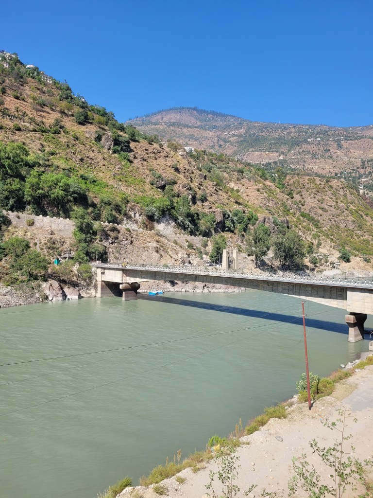
Despite the concerns and fears of local communities and scientific studies, three large hydropower projects are proposed in the 44 kms between Tandi and Udaipur. They are 104 Tandi HEP, 130 MW Rashil HEP and 175 MW Bardang HEP.
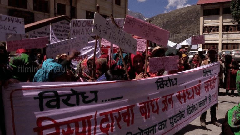
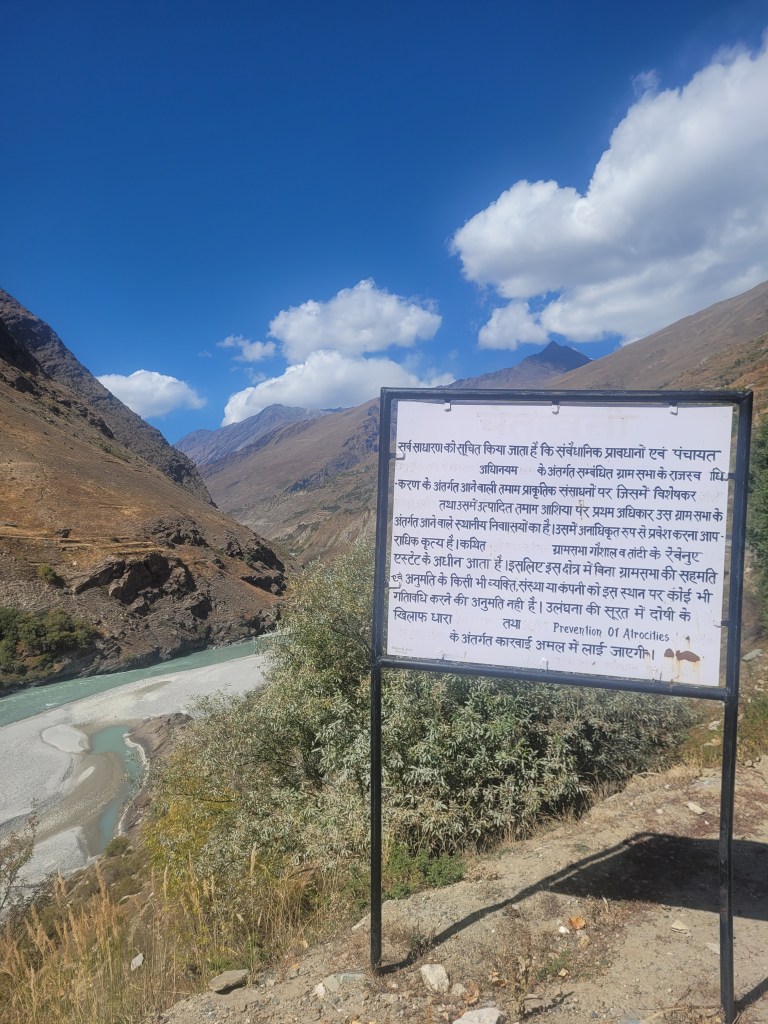
The proposed projects are making the communities restive and several villages have documented their protests against the hydropower projects under the aegis of Save Lahaul Spiti Society and Tandi Bandh Sangharsh Samiti (Committee against Tandi Dam). We witnessed several boards set up by the communities which forbid any dam-related activity in their villages.
Main contentions are increasing climate disasters in Lahaul, disasters around hydropower projects in Himalayas and loss of limited fertile valley land along the rivers.
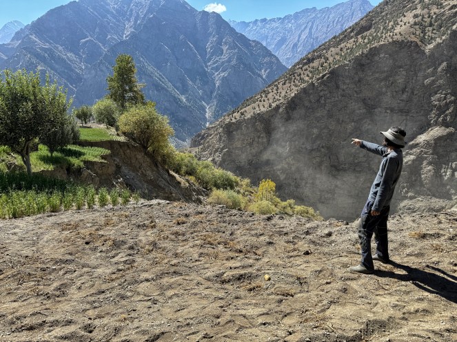
Nallahs like Jahlma are flooding even when there is no rain, resulting in massive landslides that engulf fields and block the flow of mainstem Chenab for hours. Hydropower projects planned close to this site can cause critical issues to communities. Our report here: https://sandrp.in/2025/04/17/a-sinking-village-a-stream-that-floods-in-the-sun-climate-change-jahlma-nallah-and-lindur-in-chenab-basin/
4. Miyar Basin Glaciers and Hydropower Project
Downstream from Tandi near Udaipur, Miyar Nallah is fed by Miyar glacier, at an altitude of 4200 mts[xxxi]in the Greater Himalayas.[xxxii] Miyar basin has 156 glacial lakes: highest concentration of glacial lakes in the Chandrabhaga/Chenab basin.[xxxiii] The basin is home to 120 glaciers covering an area of 314 sq kms.
Miyar basin and especially its Karpat Nallah catchment[xxxiv] has seen repeated floods, landslides and disasters which isolate the valley, cutting off its access from Udaipur and the main highway for days at end. Devastating floods have been recorded in the Miyar basin in 2013[xxxv], 2014, 2017[xxxvi], 2023[xxxvii] and 2024[xxxviii].
In this flood-prone basin with high concentration of glacial lakes and repeated flood losses to the community, 120 MW Miyar Hydropower Project has been proposed. The dam site near Shakoli village is barely 10 kms from disaster- ravaged Karpat and Changut. The project received Environmental Clearance in 2012, based on the Environmental Impact Assessment carried out even before 2012. However, in March 2025, Himachal Pradesh Government signed a Memorandum of Understanding with Telangana State Government develop the Miyar Project.[xxxix] Shockingly, the EC letter does not make any mention of Miyar Glacier, glacial lakes, flooding events, possible protective measures to be carried out by the project etc.
Local communities are strongly protesting this project and MOU.
5. Expanding glacial lake and hydropower projects in Pangi Valley
Further downstream in Pangi valley where a cascade of hydropower projects is planned, Scientists have discovered an exponentially expanding glacial lake in the headwaters of Kadu Nallah in what they term as, ‘Intimidating Evidence of Climate Change from the Higher Himalaya.’[xl]
Kadu Nala is a moraine-dammed pro-glacial lake formed around 2010 upstream of Shaor village (Altitude: 3900 meters) and has been expanding rapidly since. Projection scenarios show accelerated glacier loss and increase in the lake size.
Scientists single out the lake for Glacial Lake Outburst Flood (GLOF) event. ‘‘Because of the expected glacier lake expansion over the next decade, this lake is vulnerable to glacial outburst floods. Such GLOF events cause deaths, as well as destruction and damage to settlements, public infrastructure, hydroelectric facilities, etc.” [xli]
6. Warwan and Bhut Nallah, Jammu
A recent study by the University of Kashmir has highlighted that of the 11 High Risk glacial lakes in Jammu and Kashmir, 3 of the “highly hazardous” and most vulnerable lakes are found in the Kishtwar district of Chenab Basin. These include ‘Mundikeswar, Hangu Lake and an unnamed lake.’[xlii] According to Rai et al, 2023[xliii], Mundiksar Lake in the Kishtwar High Altitude National Park has expanded by 0.258 ± 0.16 km2 (~150%) during 1980–2020 and ‘Rapid expansion of the proglacial Mundiksar Lake has potential to affect the critical infrastructure such as Bursar and Pakal Dul dam sites in the downstream region’.
The recent Jammu floods have affected Ramban just downstream Baglihar Hydropower project.
7. GLOF preparedness and governance around GLOFs is majorly lacking in India right now. See our recent report for details: Hydropower-GLOF Nexus in Chenab Headwaters: Absence of credible studies and accountable governance[xliv]
Glaciers are receding similarly in the Jhelum basin in Jammu and Kashmir, making flows more unreliable and likelihood of disasters more frequent.
Development of any large projects in a region that is seismically active, witnesses routine, crippling climate disasters and is set to face further disasters as per climate projections, needs to be through an informed, democratic process. It needs careful planning, attention to details, rigorous studies like impact of GLOFs, landslides, flash floods etc.
There is ample evidence to show that Chenab headwaters and communities are facing significant climate pressures.
It will be important to undertake all necessary studies, safeguards and precautions before pushing further projects in this region and not take any decisions based on other considerations.
Parineeta Dandekar, SANDRP, (parineeta.dandekar@gmail.com) with inputs from Himanshu Thakkar
[ii] https://timesofindia.indiatimes.com/city/jammu/over-100-rescued-as-heavy-rain-triggers-flash-flood-in-jks-ramban-traffic-disrupted/articleshow/120450063.cms
[iii] A.V. Kulkarni et al, Glacial retreat in Himalaya using Indian Remote Sensing satellite data, Current Science, 2007
[iv] A. V. Kulkarni et al, State of Himalayan cryosphere and implications for water security, 202, https://doi.org/10.1016/j.wasec.2021.100101
[v] Gopika et al, Estimation of glacier stored water in the Bhaga basin using laminar flow and volume-area scaling methods, Remote Sensing Applications: Society and Environment, 2021, https://www.sciencedirect.com/science/article/abs/pii/S2352938521001920
[vi] Ibid.
[vii] Ibid.
[viii] Ibid.
[ix] Nagajothi et al. 2020. Mass Balance of Glaciers in Bhaga Basin, Western Himalaya: A Geospatial and Temperature-Weighted AAR based Model Approach
[x] Kaushik et al. 2018. Climate change drives glacier retreat in Bhaga basin located in Himachal Pradesh, India, https://doi.org/10.1080/10106049.2018.1557260
[xi] https://sandrp.in/2025/04/15/the-moon-river-peoples-story-of-chenab/
[xii] Tawde et al, 2019. An assessment of climate change impacts on glacier mass balance and geometry in the Chandra Basin, Western Himalaya for the 21st century, 2019, Environmental Research Communications. https://iopscience.iop.org/article/10.1088/2515-7620/ab1d6d
[xiii] Tawde et al, 2019. An assessment of climate change impacts on glacier mass balance and geometry in the Chandra Basin, Western Himalaya for the 21st century, 2019, Environmental Research Communications. https://iopscience.iop.org/article/10.1088/2515-7620/ab1d6d
[xiv] RCP 4.5 “refers to a climate change scenario known as a “Representative Concentration Pathway” where greenhouse gas emissions peak around mid-century and then decline, stabilizing the radiative forcing at 4.5 Watts per square meter by 2100, representing a moderate mitigation pathway with a significant reduction in emissions compared to “business as usual” scenarios; essentially, it signifies a scenario where moderate climate action is taken to stabilize emissions by the end of the century
[xv] RCP 8.5 “refers to a climate change scenario representing a “business as usual” pathway with the highest projected greenhouse gas emissions, signifying a future where emissions continue to rise significantly throughout the 21st century, considered the “worst-case” scenario for climate change impacts
[xvi] Tawde et al, 2019. An assessment of climate change impacts on glacier mass balance and geometry in the Chandra Basin, Western Himalaya for the 21st century, 2019, Environmental Research Communications. https://iopscience.iop.org/article/10.1088/2515-7620/ab1d6d
[xvii] Chander Prakash et al, 2018. Glacial lake changes and outburst flood hazard in Chandra basin, North-Western Indian Himalaya, https://doi.org/10.1080/19475705.2018.1445663
[xviii] Chander Prakash et al, 2018. Glacial lake changes and outburst flood hazard in Chandra basin, North-Western Indian Himalaya, https://doi.org/10.1080/19475705.2018.1445663
[xix] GLOF Risk Assessment of Samudra Tapu Glacial Lake in Indus River Basin, NRSC, ISRO, 2024, https://bhuvan.nrsc.gov.in/nhpfs/pdf/NRSC_SamudraTapuGlacialLake_GLOF_Risk_Assessment_Report.pdf
[xx] Kaushik et al, Examining the glacial lake dynamics in a warming climate and GLOF modelling in parts of Chandra basin, Himachal Pradesh, India, Elsevier, 2020, https://doi.org/10.1016/j.scitotenv.2019.136455
[xxi] https://eparlib.nic.in/bitstream/123456789/783415/1/16_Energy_43.pdf
[xxii] Ganapathi et al. 2023. Assessment of Glacial lake Outburst Flood in Chandra Basin, Western Himalaya. https://iwrs.org.in/journal/juloct2023/1600.pdf
[xxiii] Pritam Chandra Sharma, 2017, Reconstructing the pattern of the Bara Shigri Glacier fluctuation since the end of the Little Ice Age, Chandra valley, north-western Himalaya, Progress in Physical Geography, Earth and Environment
[xxiv] [xxiv] Climate Change 2007: Working Group II: Impacts, Adaptation and Vulnerability, IPCC, https://www.ipcc.ch/site/assets/uploads/2018/03/ar4_wg2_full_report.pdf
[xxv] Chander Prakash et al, IIT Mumbai, 2018 Glacial lake changes and outburst flood hazard in Chandra basin, North-Western Indian Himalaya, https://doi.org/10.1080/19475705.2018.1445663
[xxvi] Sattar et al, (2023). Modelling potential glacial lake outburst flood process chains and effects from artificial lake-level lowering at Gepang Gath Lake, Indian Himalaya. Journal of Geophysical Research: Earth Surface, 128. https://agupubs.onlinelibrary.wiley.com/doi/10.1029/2022JF006826
[xxvii] National Remote Sensing Centre, ISRO, GLOF Risk Assessment of Ghepang Ghat Glacial Lake in Indus River Basin, 2023, https://bhuvan.nrsc.gov.in/nhpfs/pdf/GhepanGhat_GLOF_TechReport_Final_29122023.pdf
[xxviii] Ganapathi et al. 2023. Assessment of Glacial lake Outburst Flood in Chandra Basin, Western Himalaya. https://iwrs.org.in/journal/juloct2023/1600.pdf
[xxix] https://www.tribuneindia.com/news/himachal/lahauls-expanding-lake-poses-threat-to-sissu-village-552783/
[xxx] Sattar et al, (2023). Modeling potential glacial lake outburst flood process chains and effects from artificial lake-level lowering at Gepang Gath Lake, Indian Himalaya. Journal of Geophysical Research: Earth Surface, 128. https://agupubs.onlinelibrary.wiley.com/doi/10.1029/2022JF006826
[xxxi] Patel at al, Geospatial observations of topographical control over the glacier retreat, Miyar basin, Western Himalaya, India, 2018, 10.1007/s12665-018-7379-5
[xxxii] Das et al, Inventory and GLOF susceptibility of glacial lakes in Chenab basin, Western Himalaya, 2024, https://doi.org/10.1080/19475705.2024.2356216
[xxxiii] Bhambri et al, Glacial Lake inventory of Himachal Pradesh, Wadia Institute of Himalayan Geology 2018, https://www.researchgate.net/publication/323279840_Glacier_Lake_inventory_of_Himachal_Pradesh
[xxxiv] https://www.tribuneindia.com/news/himachal/flash-flood-devastates-miyar-valley-of-lahaul-spiti-644303/
[xxxv] https://timesofindia.indiatimes.com/india/flash-floods-damage-road-bridge-in-lahaul/articleshow/21948153.cms
[xxxvi] https://reliefweb.int/report/india/cloudburst-floods-wreak-havoc-lahaul-spiti
[xxxvii] https://sandrp.in/2023/08/03/rivers-breaching-highest-flood-levels-in-july-2023/
[xxxviii] https://www.tribuneindia.com/news/himachal/flashflood-cuts-off-remote-miyar-valley-from-udaipur/
[xxxix] Himachal Pradesh and Telangana Ink Historic MoU for 520 MW Hydro Power Projects in Lahaul-Spiti
[xl] Nawaz Ali et al, Intimidating Evidences of Climate Change from the Higher Himalaya: A Case Study from Lahaul, Himachal Pradesh, India, 2023 Journal of the Indian Society of Remote Sensing 10.1007/s12524-023-01686-0
[xli] Nawaz Ali et al, Intimidating Evidences of Climate Change from the Higher Himalaya: A Case Study from Lahaul, Himachal Pradesh, India, 2023 Journal of the Indian Society of Remote Sensing, 10.1007/s12524-023-01686-0
[xlii] J&K Has 11 ‘High-Risk’ Alpine Lakes at Risk of Catastrophic GLOFs, Finds Study https://thewire.in/environment/jammu-kashmir-glof-risk-lakes
[xliii] Rai et al, Four decades of Glacier and Glacial Lake dynamics in Kishtwar high altitude National Park, Chenab Basin, Jammu and Kashmir, India, 2023, https://link.springer.com/article/10.1007/s40808-023-01836-w
[xliv] Dandekar P, Hydropower-GLOF Nexus in Chenab Headwaters: Absence of credible studies and accountable governance, SANDRP, April 2025,https://sandrp.in/2025/04/10/hydropower-glof-nexus-in-chenab-headwaters-absence-of-credible-studies-and-accountable-governance/

Beyond Indus water treaty suspension: A ‘nationalist’ push despite harsh climate realities https://www.counterview.net/2025/04/beyond-indus-water-treaty-suspension.html
LikeLike