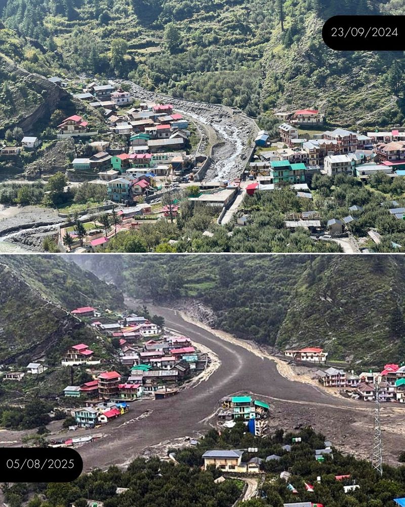
The frightening debris-laden flash flood disaster at Dharali town along Kheer Gad-Bhagirathi river just 20 km downstream of Gangotri at around 1.30 pm on Tuesday, Aug 5 has demolished over 40 buildings, with scores (68 as on Aug 13 as per the Dehradun-based State Emergency Operation Centre) of people, including nine army jawans, reported missing (the numbers could go up as per several geologists) and at least five dead. The ground zero is still largely inaccessible four days after the disaster. While the full details of what caused the disaster are still a bit uncertain, what is clear is that the warning signs were present, they were ignored and a number of human causes amplified the proportions of the disaster. The scene of the disaster was similar to what we saw in Chamoli in Feb 2021 when ice and debris laden stream destroyed two hydropower projects killed over a hundred people.
As geologists said, the disaster was waiting to happen, but our governance did not seem to know.
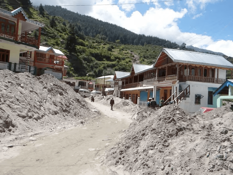
A 500-metre-wide swathe of land was buried under debris and sludge, with mounds reaching up to 50 feet high — enough to swallow a three-storey building. A drone team was sent upstream along the Kheer Gad stream to assess whether a lake or pond formed following the deluge. It could take several months to completely remove the debris from Dharali.
So much debris flowed into Bhagirathi from Dharali that it partially blocked the flow of Bhagirathi just downstream from Dharali. However, since the block was partial, water continued to flow downstream even with the impoundment upstream. The Central Water Commission Flood Forecasting officials confirmed the blockage in response to SANDRP tweets. On Aug 9, PTI and ANI came out with videos showing the lake formed due to the blockage of Bhagirathi river by the debris.
The disaster devastated Dharali — a beautiful Himalayan town in Uttarkashi district of Uttarakhand along the Bhagirathi-Kheer Gad confluence about 20 km before Gangotri – the origin of Ganga-, a portion of Harshil, six kilometres downstream along Bhagirathi, known for its apple orchards and army camp, and some nearby settlements. The region remains cut off from the rest of the state due to landslides, sunken roads, broken bridge and a submerged helipad. There is video of Dharali Disaster on Aug 5 (Round 1 and later in the day Round 2) and another video of similar debris laden flash flood on the same day, possibly at Harshil. The second wave of debris flow in Dharali destroyed the buildings that were not destroyed in first wave.
The Ministry of Jal Shakti came out with a status report on Aug 5 2025 evening, mentioning three cloudburst events, one at Dharali, one at Harsil and third in nearby area. This suggestion turned out to be totally wrong, IMD figures show that there was no cloudburst at any of these locations. This was similar to the suggestion of cloud burst made by CWC on Oct 3-4 2023 in South Lhonak lake area in Sikkim, leading to washing away of the Teesta 3 dam. That suggestion also proved to be wrong.
Dharali is situated at an altitude of nearly 2,745 meters (9006 ft) above sea level, at the base of Srikant Mountain.
Uncertainty prevails over the cause of the Dharali disaster.

Cause of the Dharali disaster The area near Dharali village did not receive heavy rain in the hours preceding the calamity. The rainfall in Uttarkashi district for the 24 hours ending at 0830 hrs on Aug 5 and 6, as per India Meteorological Department’s daily bulletins was 16 and 32.2 mm. In theory, locations upstream of Dharali could have received high rainfall or even cloudburst as initially speculated, but there is nothing as yet to substantiate that. “It is possible that there is a glacier lake overflow or heavy rain triggering a landslide of accumulated silt and debris,” Vineet Kumar Gahalaut, Director of Wadia Institute of Himalayan Geology said.
Noida-based satellite imagery company Suhora Technologies said that a ‘cloudburst’ was probably a cause as their analysis showed there were no glacier-fed lakes or large water bodies that had spilled over. “We have used synthetic aperture radar (SAR) imaging from the ICEYE satellite and checked upstream of Dharali village. There is no glacier lake or water body. It does look like rainfall was a trigger,” Subhajit Bera of Suhora Technologies said, adding, “However, we don’t yet have images from the upper stretches and so don’t know the exact causes yet.”
“Our analysis is ongoing, so, currently, we can neither fully confirm nor rule out the possibility of a cloudburst near Dharali. Further analysis is required to understand whether a cloudburst occurred,” Asst Prof Ankit Agarwal of Dept of Hydrology at IIT Roorkee said.
Harsil received just 6.5 mm of rainfall on Aug 5. The cumulative rainfall in Harsil and Bhatwari over 24 hours was 9 mm and 11 mm, respectively. Instead, either a landslide blocked dam burst or a glacial pond burst could be behind the deluge.
A video on Aug 10 very well explains why this was not a disaster due to cloude burst.

Glacial Pond Outburst? “The river, Kheer Ganga, originates in snow-covered area at a steep altitude. There are several glacial ponds in this area. Due to heavy rain and the melting of snow, these ponds had filled up. I think one of these ponds burst, and caused others to burst. And then water and debris flowed downstream with great force. The gradient is also very high. And then it hit Dharali,” Dr DD Chauniyal of Doon University’s Nityanand Himalayan Research and Study Center said.
He added that the Kheer Gad (also called Kheer Ganga by some) river flows downstream to merge with the Bhagirathi and Dharali is located near the confluence. Over the years, buildings have been constructed on both sides of Kheer Gad’s course. The river had a different route earlier. With time, the course changed and the river started flowing upstream. On Aug 5, the debris-laden river flowed along its previous course and also in the area between the old and new course, where settlements had come up, razing hotels, homes, homestays, roads and markets. The old Dharali village, located to the right of the river flowing downstream, is largely safe even though the area on its left was wiped out within a minute. The flow abruptly stopped after that.

Landslide expert Dave Petley in his blog on Aug 5 suggested that the cause could be one large landslide or multiple small landslides or a valley blocking landslide. Prof Petley in his blog on Aug 6 rightly warned: “In continued heavy rainfall, one cannot preclude further failures in the valley above Dharali. Ensuring the safety of the rescue personnel in light of this threat is going to be paramount.”
Imran Khan’s debris flow suggestion Imran Khan of the landslide division at Bhutan’s Punatsangchhu HEP-I has suggested after a preliminary investigation a more complex and violent trigger – a massive collapse of glacial sedimentary deposits, possibly caused by a slope failure high up in the mountains. This large body of material is located at [30.9799, 78.7965] and has a volume of about 360 million m3 (only a small fraction of this is likely to have moved). It is vast – up to 300 m thick, spread over about 1.1 sq km. Imran says this mass might have generated the debris flow. Petley says: “Certainly the deposit in the post-failure images is consistent with this mass, and the volume is sufficient, so this theory is credible.” The avalanche was mobilised by a sudden release of unstable morainic and glacio-fluvial material-thundering down the steep Kheer Gad stream into Dharali. The surge reached the village within seconds. Khan says: “The glacial deposits were perched roughly 7 km upstream at an elevation of 6,700m. Heavy rainfall may have acted as the trigger-but the disaster was waiting to happen.”
Rajiv Saran Ahluwalia, geologist at Doon University said that at velocities of 6-7m per second, debris-laden flows are capable of destroying any structure in their path: “Something extraordinary happened up there. It needs urgent investigation.”

Dr. Navin Juyal explains and warns: Navin Juyal, Uttarakhand’s most outspoken geological scientist, provided a scientific explanation of the disaster in the video titled “Ice-Rock Avalanche near Gangotri”: The affected Dharali stretch lies at the base of a steep slope covered with towering deodar trees, amid rocks and boulders brought down by small mountain streams and frequent avalanches. The trees arrest the avalanches and their roots stabilise the slopes.
Several “hanging glaciers” – hollowed glacial ledges full of rocks, boulders and other debris left behind by receding glaciers in the past – dot the crests of the slopes. Five or six small streams emerge from these and rush down the slopes as they have very high stream power. These streams can create havoc during periods of intense summer monsoon rains. Rising temperatures on the high crests melt the winter snows that quickly form massive avalanches, along with ice, rain water and the glacial moraines, as they rush down the stream valleys. The recent catastrophes were due to such avalanches, Juyal explained.
Dr Juyal warns that to broaden the highway in this stretch, some 6000 deodar trees have been marked for felling. To cut these trees would be a big mistake and an invitation to more disasters in the region, he has warned. He suggested that if at all there is justified need for broader roads, this should be achieved through elevated corridors closer to the river rather than felling these trees. This recommendation of avoid felling deodar trees is not being followed. The BRO’s push for cutting the 6,000 deodar trees is also in violation of a Supreme Court judgment of December 14, 2021, regarding the Char Dham project, which gives directions to avoid felling of deodar trees. In view of the August 5 disaster in Dharali and the need to maintain slope stability in and around the village, Juyal and HPC member Hemant Dhyani submitted a note to MoRTH on August 12, urging it to consider an alternative approach to widening the Jhala-Jangla stretch to save the 6,000 deodar trees from being felled.
He also showed in his video that after the June 2013 disaster too, Kheer Gad had activated its old stream downstream flowing through it, and there should have been a warning to not allow any habitations in the floodplain of the river. Instead, government seems to have encouraged encroachment in the floodplain by building a cement concrete wall along the Kheer Gad current channel in an attempt to channelise it. He said, Himalayan streams cannot be channelised through such RCC walls as the rivers bring not only water, but also debris including huge boulders. His video also showed that the area full of debris of past avalanches, suggesting that the area is avalanche prone. The trees help reduce the avalanche vulnerability and cutting them would make the area more vulnerable to avalanches.
Dr Juyal in the video shows a photo of Dharali temple (possibly Kalpa Kedar Temple) dated 1935, the temple was right in the fan shaped confluence delta between Kheer Gad and Bhagirathi. The temple was then submerged in the period since 1935. In the 1980s, the debris was removed to bring out the temple. The temple could be seen in a recent photo shared by him, being below the riverbed level.
Dr Juyal says that Kheer Gad has been a source of such debris laden sudden flash floods in the past too, but no lessons are learnt as can be seen from the RCC wall built along the river to contain it after the 2013 disaster.
As Journalist and researcher Kavita Upadhyay wrote: :”Since snowfall extended to March-April, the cavity in front of the cirque glacier that feeds the Kheer Gad may have had high snow mass, which was also high in water content. Consecutive rainfall between August 3 and 5 may have made the cavity exceed its capacity. Cracks may have developed in the water-saturated mass, and then part of it may have toppled, resulting in an ice-rock avalanche in the Kheer Gad,” Dr Juyal said.
“Considering the steep slope, the avalanche may have quickly collected the glacial moraines (that include boulders, silt, and clay) and would have descended downwards speedily with all this accumulated mass.”
“Along the stream’s path to Dharali are existing landslide zones, which may have temporarily, for no more than a few hours, obstructed the flow of the mass. When these obstructions breached, they caused a sudden release of sediment, water, and boulders that ravaged Dharali within seconds.”
Kavita Upadhyay wrote: “Besides the Kheer Gad, two nearby streams – Harsil Gad and Jhala Gad, located just 4-6 km away – were also flooded on August 5. At Harsil, which is about 4 km from Dharali, an Indian Army camp was damaged, and at least nine personnel went missing due to the flood. Juyal posited that since all three streams lie close to each other and originate from a similar geomorphological setting, that is, hanging glaciers, Harsil Gad and Jhala Gad may have also experienced rock and ice avalanches similar to Kheer Gad.”
Upadhyay further wrote: “Senior Geologist Yashpal Sundriyal too said the flood did not appear to have been triggered by a cloudburst. He explained that cloudbursts mostly occur on the south-facing slopes of the Himalaya due to the behaviour of clouds under the influence of the southwest monsoon. However, the Kheer Gad, which was activated, originates from a north-facing slope. “It is rare to experience a cloudburst in a north-facing slope in the Himalaya,” he said.”
The Bhagirathi valley (about 100 km stretch), between Uttarkashi to Gangotri, covering about 4180 sq km, was declared as an eco-sensitive zone (ESZ) on December 18, 2012 under the Environment Protection Act, 1986. Thus, barring the construction of power projects less than 2MW besides use of water for industrial purposes, quarrying and mining, there is blanket ban on felling of trees, etc. This was to preserve its pristine areas and regulate infrastructural activities. Central and state governments, however, have been lax in enforcing the regulations, despite the efforts by some members of an MoEF&CC appointed monitoring committee.
In 2020, Juyal, as a member of the Supreme Court directed High Powered Committee (HPC) to investigate the construction of the Char Dham highway, warned his committee colleagues, BRO engineers and senior Uttarakhand and central government officials of the high probability of repeated future avalanches due to global warming and climate change.
Manish Kumar, an ecohydrologist described debris-flow fans as “safety valves” of streams like the Kheer Gad, which flow through steep slopes before entering flatter areas: “Constructing over these fans is like choking the stream’s safety valves. The stream is bound to break out and reclaim its area sooner or later, which is what happened in Dharali.”

Dr Ravi Chopra Chairman of two High Level Committees appointed by the Supreme Court of India for Uttarakhand, Dr Ravi Chopra has written in the context of this disaster: “Mountain researchers have been studying and issuing warnings for decades now, in print and at high-level conferences where decision-makers are participants, that the Himalayan region is more vulnerable to climate change than most other parts of the Indian subcontinent. They have identified specific sensitive areas in the Himalaya and the policies and actions needed to avoid disasters or minimise their impacts. They have pointed out that HEPs should not be built in para-glacial regions, human settlements and built structures be located at safe distances from flood-prone rivers, particularly small mountain streams that can suddenly turn treacherous, road widening along slopes steeper than 30 degrees should be avoided, and that carrying-capacity studies are desperately needed in the Himalayan towns and cities. Senior government officials pay lip service to these recommendations but do nothing to implement them.”
Sept 2022 satellite image showed glacial lakes Senior Glaciologist Anil V Kulkarni said that satellite images from September 2022, a non-winter month, showed clues of past lake formations in the area from where the Kheer Gad originates. “September 2022 imagery shows that snow was melted, and one can clearly see landforms. A well-developed deglaciated valley bounded by end moraine can be seen and a small river is passing between the end moraine and a side wall,” he said. Kulkarni said there were indications that the lake might have formed due to a landslide from the end moraine: “The (Dharali) flash flood of mud flow might have been caused due to an outburst of the lake. This could also explain past floods in the Kheer Ganga River.”
According to one report, stones were falling from the Shrikhand mountain since a week before the disaster, which people saw and discussed, but did not inform the administration or take any action.
Earlier disasters around Dharali Area around Dharali has seen a number of similar disasters in the past.
– The Kalp Kedar temple in Dharali was submerged in the river bed in Dharali and other shrines were destroyed during 1935-38, which was part of the glacial shifts in Bhagirathi valley during 1891-1938.
– In 1978, in Dabrani, downstream from Dharali, a massive landslide led to blocking of Bhagirathi river on Aug 6, and disaster downstream when the block breached on Aug 11. This was the Kanodia Gad Landslide Lake Outburst flood[i]. “The remnant of the landslide debris can still be seen, which has transformed the channel morphology from a reasonably wide confluence to a constricted passage for the Bhagirathi river”. In case of the current Dharali disaster too, the debris have partially blocked the Bhagirathi River.
– The 1991 Uttarkashi earthquake led to shifting of moraines in the upstream of Dharali.
– 2010-2014: Bhatwari settlement after 2010 extreme rainfall and during the winter of 2014. Since then there is no respite as the slopes are continuously creeping. It was worrisome that the Loharinag-Pala project power house was coming up just above the town. The project now stands cancelled. Bhatwari is downstream from Dharali.
– Aug 2012: Asi Ganga Disaster in Bhagirathi valley, downstream from Dharali due to cloud burst.
– June 2013 disaster also affected Kheer Gad & Dharali as mentioned by Dr. Navin Juyal above. Then, large amounts of sediment and rocks brought by the stream were deposited in the Dharali market area. A few hotels near the stream were damaged, many buildings were filled with five to 10 feet of sediment, and several cars were buried under the sediment
– July-Sept 2016: A landslide on Sonam river (Bhagirathi basin) in Bhatwari block in Uttarakashi district in Uttarakhand has blocked the flow of the river and created a lake about 90 m long, 80 m wide and 1.5-3 m deep. The landslide dam in Nelong valley in Jadhganga river basin about 145 km from Uttarkashi town, apparently was formed due to landslide during cloud burst on July 27, 2016, but the information about it reached the administration only on Sept 4, 2016, 39 days later. The landslide dam, about 24 km from the India China border has created a threat to the downstream river bank communities, roads and bridges and other structures and also ecology. The reservoir has been formed at the confluence of Angar Nallah, a local stream, with Sonam River. A team of officials sent by the District Collector on Sept 5, 2016 has submitted a report, but the report is not yet in public domain.
– In 2018 too, Dharali residents recalled that they witnessed a flood.
Mukhba Village at risk Mukhba (winter home of Goddes Ganga), perched at 2,600 metres in Uttarkashi’s Harshil valley, on opposite bank of Bhagirathi from Dharali, is now under threat as the Bhagirathi river has sharply altered course in the disaster’s aftermath. Once flowing midstream, its waters now slam into the hillside directly below Mukhba, accelerating soil erosion and threatening the village of nearly 500 residents. Chunks of land have already been swallowed by the current, taking with them the villagers’ sense of safety. (Updated on Aug 14 2025)
Yet another wake-up call The Dharali tragedy has yet again brought to the spotlight the perils of unplanned construction in the ecologically sensitive Himalayan region. The trigger for the burst of glacial pond or lake upstream of Dharali was possibly a combination of snowmelt and rainfall. But the fact is this waiting-to-explode disaster situation prevailed for long, but was not even under our monitoring radar.
Kheer Gad River’s occupation of the old course during the disaster should remind us that we can and must change the course of so called ‘development’ along rivers. We have highlighted several such disaster prone sites in the Chenab Basin recently. The fact that army jawans are also missing in this disaster should remind army that it too needs to be careful about encroachments and constructions in the path of the river.
Let us hope our governance wakes up sooner rather than later. And that an independent assessment of this disaster is instituted soon once the rescue and relief phase is over.
SANDRP
[i] “Geo-environmental consequences of obstructing the Bhagirathi River, Uttarakhand Himalaya, India” by SP Sati et al, GEOMATICS, NATURAL HAZARDS AND RISK 2020, VOL. 11, NO. 1, 887–905 https://doi.org/10.1080/19475705.2020.1756464

Earlier we knew Eco-sensitive zone means absolutely no construction ever than those primitive settlements but that seems to be obsolete now. In 2013, even Gangotri was hit by flash floods. But the way these places have been “developed”, many of these big and small hamlets enroute are likely to be hit by flash floods in coming years. Cutting down Deodar trees along this highway would be another serious blunder even for helipad zones. Plan of broadening the Gangotri highway in this part or elevated corridor should be absolutely abandoned if our government is ever serious about “strategic importance” because even army and ITBP troops become victims of such flash floods who are the real backbone of our country’s security. Once locals used to be in coordination with the army and ITBP for safety information about this route which seems to have vanished. Some good reporting has been done by Baramasa and Hridayesh Joshi but very few reporters are allowed to reach Dharali, perhaps to manage headlines because that’s the only thing left for policy makers as part of disaster management. Since exact figures of casualties are yet to be announced and probably will never be as was in Rishiganga valley, we can assume any number between 500 to 1000 or even more.(Kedarnath disaster claimed 5000 as official figure though many witnesses believed it was at least 15000 to 20000).
We should genuinely feel sorry about the way developments are ongoing in Uttarakhand and Himachal and Sikkim because these practices are destroying the Himalayas and the whole ecology including the major rivers coming down from this region. The pristine hills and the rivers should be protected at all time because these places are intertwined with specific cultures that are unique and used to be our heritage, according to old scriptures.
LikeLike