The state of Assam in the northeastern India annually bears the brunt of floods and where embankment construction and repairing seems like permanent affair. Displacement of people living on the banks of rivers due to river bank erosion is another major issue here. The braiding and meandering river Brahmaputra and its tributaries continue to erode the banks rapidly. The Brahmaputra is well known for the rate in which it erodes. Among the places in the path of the river where the brunt of erosion has been felt severely include the following:
– Rohmoria and Dibrugarh town in Dibrugarh district,
– Matmora in Dhakukhana subdivsion of Lakhimpur district,
– Majuli and Nimati Ghat in Jorhat district,
– Lahorighat in Morigaon district and
– Palashbari and Gumi in Kamrup district.

SANDRP recently traveled to Matmora and Nimati ghat, two of these areas.
Bearing the Brunt of Erosion Silently Once a large village now only the name Matmora remains. Locals show us towards the middle of the river, to indicate where the village used to be. The rate of erosion is such that the Brahmaputra dyke from Sissikalghar to Tekeliphuta (popularly known as Sissi-Tekeliphuta dyke/embankment) takes the shape of a bow for nearly five kilometers at this place. From 2010, Matmora became very significant in the embankment history of India since country’s first embankment using geo-textile technology was constructed here. This was constructed at the bow shaped eroded line using geotextiles tubes. These tubes were filled up using water and sand from the banks of the river. This five kilometer embankment became a part of the Brahmaputra dyke from Sissikalghar to Tekeliphuta which is 13.9 km long. For the state government and Water Resources Department (WRD) of Assam, Matmora geotube embankment is a story of success of preventing floods and erosion. But what we saw in Matmora presents a different picture.
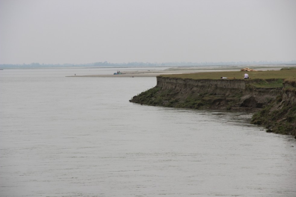
At Nimati Ghat, the river Brahmaputra is eroding its banks ferociously and people are intimidated by the river. A local person whose village used to be nearly two kilometers from the present bank line, told me, “Nothing can stop Baba Brahmaputra from claiming what he wants”. At Nimati Ghat, the Water Resources Department (WRD) is doing anti erosion work using geo-bags.
Funding for Embankments in Assam The total length of embankments in Assam is 4448 km as stated in a debate in the Legislative Assembly of Assam in 1998. Even though the present length of embankments is not known, it is very clear that the state of Assam continues to construct of newer embankments. In a recent analysis by SANDRP, it was found that the funds continue to increase for construction of embankments in the state. In five years from January 2009 to December 2013, the Advisory Committee in the Union Ministry of Water Resources for consideration of techno-economic viability of Irrigation, Flood Control and Multi-Purpose Project Proposals (TAC in short) had given clearance to projects worth Rs 1762.72 crores. A detailed list of these sanctioned projects can be found in Annexure 1 below.

Has Geo-tube been helpful for the people Between January 2009 to December 2013, the Brahmaputra dyke from Sissikalghar to Tekeliphuta, was considered twice by the TAC. The committee in its 95th meeting on 20th January 2009 accepted the project titled “Raising and Strengthening to Brahmaputra dyke from Sissikalghar to Tekeliphuta including closing of breach by retirement and anti-erosion measures (to protect Majuli and Dhakukhana areas against flood devastation by the Brahmaputra, Lakhimpur district, Assam). The estimated cost of this project was Rs 142.42 crore and its project proposal envisaged – (i) Raising and strengthening of embankment for a length of 13.9 km, (ii) Construction of retirement bund with geo-textile tubes of length 5000 m. (iii) Construction of 2700 m long pilot channel.

Protection work of the same dyke was considered in the 117th meeting held on 21st March 2013 under the proposal for “Protection of Brahmaputra dyke from Sissikalghar to Tekeliphuta at different reaches from Lotasur to Tekeliphuta from the erosion of river Brahmaputra Assam.” The estimated cost of this project was Rs 155.87 crore. According to the minutes of 117th TAC meeting, the scheme envisaged “restoration of existing embankment in a length of 15300m at upstream and downstream of existing geo-tube dyke, Sand filled mattress in a length of 15604 m at river side slope, geo-tube apron length of 7204 m and Reinforced concrete porcupines as pro-siltation device at different reaches to prevent floods and erosion in Dhakukhana Civil sub-division of Lakhimpur district and Majuli sub-division of Jorhat district.” In the same minutes,while referring to the previous project proposal of 95th meeting the minutes stated that, it “was taken up primarily for closure of breach in the existing embankment including raising of embankment around the breach area only. The proposed works in the present scheme were in the same river reach and these would be required to protect the bank from further erosion and provide flood protection.”
This clearly shows that the geo-tube embankment in Matmora cannot be called a success. Government documents which showed that major part of the Brahmaputra dyke from Sissikalghar to Tekeliphuta remained vulnerable even after the construction of the geo-tube embankment. In fact submitting a proposal for the whole Sissi-Tekeliphuta embankment at first and later saying that the money was spent in constructing a smaller part of the embankment also raise questions. The time gap between the two proposals also raises questions. If the whole money from first proposal was to be spent in constructing only a part of the embankment, why was it not stated clearly in the first proposal? In fact, this was not stated in the first proposal and second proposal reflects that the first project failed to achieve the objectives. If the first proposal was indeed only for part of the embankment, why the proposal to strengthen the larger part of the embankment took 5 years to appear before the committee? The latter proposal also did not mention about the breach which swept away a large part of the Sissi-Tekeliphuta embankment from Jonmichuk to Amgiri Tapit under Sissikalghar and Jorkata village panchayat. According to the local people this breach occurred in the morning hours of 25th June 2012. The photo below shows the breach happened at the Jonmichuk end.

Jonminchuk area is nearly 15 km upstream of the geotube embankment in Matmora and part of the Sissi-Tekeliphuta embankment. A new embankment of nearly four kilometer long is being constructed at this place but the remnants of the old embankment still exist. The embankment was breached for nearly 3 kms and the water which entered the fields during that time could no longer go out and a large lake has been formed at this place, see the photo. It was surprising to see people living in the patches of the old embankment.
In the downstream, right from the point where the geo-tube embankment ends, the condition of the Sissi-Tekeliphuta embankment is pathetic. There were cracks in the embankment and water seepage has almost shattered the embankment. The embankment was in need of urgent repairs.


Besides, one does not have to travel far to find erosion in the downstream of the geo-tube embankment. After travelling, less than three kilometers from the end point of the geo-tube embankment, rapid erosion was observed at the place where the Matmora and Tekeliphuta ghats join, due to low water level. This joint ghat is more than a kilometer from the toe line of Sissi-Tekeliphuta embankment but seeing the rapidity of the erosion the locals opine that the river would reach the toe of the embankment within this monsoon. It was difficult to believe that the river can erode so fast, until a young man pointed towards a black line in the middle of the river and said that that area which now seemed to be char/sand bar used to be his village three years back. He with his family now live beside the embankment. In this ghat we also witnessed that spurs constructed from the embankment inside the river, mainly to divert the flow of water, have been eroded as well.


It is also important to note that protection of Majuli from floods was one of the main aims of the geo-tube embankment project, but there were reports of devastating floods affecting Majuli in 2012 & 2013.
After geo-tube comes geo bags With the construction of geo-tube embankments being hailed as a success by the state government, construction of embankments using geo-bags followed. Geo-bags are smaller than geo-tubes and come at a cheaper cost. Embankments on many rivers were constructed using geo-bags which were also used for erosion protection. But effectiveness of the geo-bags as protective measure to flood and erosion, still remains disputed. A news report titled “ADB, river engineers differ on geo-bags” published in Assam Tribune on 9th September 2010 reported about the difference of opinion among the water resource engineers of Assam and powerful lobby of the Asian Development Bank (ADB) for the use of geo-bags to resist Brahmaputra erosion in Palasbari-Gumi and Dibrugarh. Referring to the engineers the news report stated “They have alleged that the ADB provided 23,000 geo-bags for an experiment. They were dumped in the month of September 2009 at a 150-metre-long selected erosion-prone reach at Gumi for testing their efficacy. But, a diving observation made in the month of December 2009, suggested that the bags were not launched uniformly in a single layer as it was claimed. They were found lying in a haphazard manner in staggered heaps with gaps in between and the total distance they covered was only about 8 metres, against the claimed and required 35 metres…..The ADB then carried out another diving observation at Gumi in May last (2010) and found no bag at the site. The State WRD did not get any feedback from the ADB on this issue.”


Nimati Ghat was the other place which SANDRP visited to find out the effectiveness of geo-bags. The work of piling up the geo-bags for erosion protection was going on when SANDRP visited the area in the second week of April 2014. The bags which were used previously for the same purpose were seen to be mostly lying in water in shattered condition. Locals told us that majority of the bags are now under water. In the eroded bank line, these geo-bags were lying without any order and in a way suggesting how the river has dealt or to say played with these jumbo bags. In this bank line, there was a stretch of nearly five meters where the river has eroded more than the other parts. At this stretch none of the geo-bags were to be seen.
There were also contradictions regarding when the present erosion protection work at Nimati ghat had started. Some of the shopkeepers of the ghat said that the work of putting up geo-bags started in February 2014. But according to the contractor in charge of the work, the work started in November 2013. Construction or repairing of embankment just few months before the advent of monsoons is one of the constant criticisms, leveled against the Water Resources department of the state and in Nimati too we heard the same complaint.
Is Geo-tube really a ‘permanent solution’ to floods? In the present discourse of floods in Assam this has become a very significant question. The local people have been fed with various information about geo-tube and most of which are wrong. The life of embankment constructed using geo-tube is of 100 years, we were told by the locals when we travelled to the upstream areas of Matmora geo-tube. This is absolutely not true. In fact, for Prof Chandan Mahanta of IIT Guwahati the scouring[1] done by the river Brahmaputra will be the major cause of concern for geo-tube embankments in the long run.
The geo-tube embankment has already faced threat of scouring right after its construction in the monsoons of 2011. It was on the morning of 14th July, 2011 when two of the apron tubes at the tail of the embankment, were launched due to increase force of water. The apron tubes were laid at the toe of the geo-tube embankment and with the increased force of water scoured at the bottom by the embankment toe line. WRD engineers flung into action and immediate repairing work was taken up at the site. According to WRD engineers this had happened because the trees which were left outside the embankment had obstructed and increased the force of water and they were immediately cut down. Concrete porcupines were also thrown into the water. Asomiya Pratidin, a regional newspaper reported this on that day but thereafter no report on this could be found. The incident was almost forgotten. When we visited the geo-tube embankment, it was observed that along the toe-line of the embankment a scour line runs for substantial length of the embankment. This clearly shows that scouring by the river has increased in this area. The news report published in Assam Tribune [2]also points out a significant problem associated with geo-bags – “The lobby is mounting pressure for use of geo-bags in the form of bank revetment. Bank revetment is generally not adopted in Brahmaputra because of many reasons. Most important of them is – it produces a permanent deep channel along the existing riverbank.”
On the issue of lobbying behind geo-tube, an interesting perspective was provided by activist-researcher Keshoba Krishna Chatradhara who coordinates ‘Peoples’ Movement for Subansiri and Brahmaputra Valley (PMSBV)’. He opines that the construction of geo-tube embankment in Matmora was an experiment, done to see whether such embankments can withstand the flood and erosion of Brahmaputra. The reason for choosing Matmora first and not other severe erosion affected places like Dibrugarh or Rohmoria, was because even if the embankment fails it won’t be as significant loss for the state compared to those places. Dibrugarh is one of the most important towns of upper Assam with a glorious history whereas Rohmoria became important for the state when Oil India Limited found oil deposits in Khagorijan[3]. Infact several local people and activists also opined that the Sissi-Tekeliphuta embankment which is on the north bank of the river was cut several times, to save the areas in the upstream south bank, mainly the Dibrugarh town. They said that in the past, before the geo-tube embankment came, whenever there was any news of water rising in Dibrugarh, there would soon be a breach in Sissi-tekeliphuta embankment. In fact considering these breaches in the larger Sissi-tekeliphuta embankment, Mr. Chatradhara opined that even if the geo-tube embankment survives the flood, erosion and breaches in future, it might become a small island in midst of a submerged land as there will surely be breaches in the rest of the Sissi-Tekeliphuta embankment.
ADB loan for Geo-textile Embankments in Assam After the construction of the geo-tube embankment at Matmora, the state government is leaving no stone unturned to make it sound like a glorious success. But it is surprising to know that, even before the Matmora embankment was commissioned in December 2010, the state government have filed proposal for two more embankment project where geo-textile would be used for construction and got it cleared. The two subprojects of Assam Integrated Flood River Bank Erosion Risk Management Project (AIFRERM) in Dibrugarh and Palashbari were cleared in the 106th meeting of TAC held on 16th September 2010. It is important to note that for the total AIFRERM project ADB is giving a loan of $56.9 million. The cost of Dibrugarh and Palashbari subprojects are Rs 61.33 crore and Rs 129.49 crore respectively. But these investments have been cleared without even doing a post-construction impact assessment of Matmora geo-textile embankment. The Palashbari subproject also included erosion protection for Gumi area through the use of geo-bags but the Assam Tribune report quoted above already mentioned about how geo-bags scheme has failed in that area.
It is important to note here that, the first geo-tube embankment has been constructed only three years back and it would be premature to give any verdict of success, on the contrary there are many signs of failure. But the state government of Assam and the Assam Water Resources department are claiming it as success without really any credible basis and than have used that self certification to go on building more embankments using geo-textile and in several occasions these plans have failed. They first should have done a detailed impact assessment of the embankment at Matmora before going on building more embankments of the same nature.
It seems the Assam government, ADB and CWC are pushing these projects to deflect attention from the failure of embankments in flood management. Such attempts won’t succeed, but it is possibly a ploy to prolong the use of embankments as a flood management technique.
Parag Jyoti Saikia (meandering1800@gmail.com)
Annexure 1
Flood and Erosion Projects approved for Assam – 2009 to 2013
| TAC meeting no & date | Project | Appr. year | River/ Basin | L of Emba. (m) | Original (revised) Cost-CrRs | Benefitting area (Ha) | Decision |
| 95th -20.01.2009 | Protection of Sialmari Area from the erosion of Brahmputra | 2002 | Brahmaputra | NA | 14.29 (25.73) | NA | Accepted |
| Protection of Bhojaikhati, Doligaon and Ulubari area from the erosion | 2002 | Brahmaputra | NA | 14.52 (27.92) | NA | Accepted | |
| Raising & strengthening Brahmputra Dyke from from Sissikalghar to Tekeliphuta including closing of breach by retirement and anti erosion measures | New | Brahmaputra | NA | 142.42 | NA | Accepted | |
| 96th -16.02.2009 | Flood protection of Majuli Island from Flood and Erosion Ph-II & III | New | Brahmaputra | NA | 115.03 | NA | Accepted |
| Restoration of Dibang & Lohit rivers to their original courses at Dholla Hattiguli | New | Brahmaputra | NA | 23.32 (53.11) | NA | Accepted partly & suggested that proposal of coffer dam, pilot channel, etc. to be put up for expert opinion | |
| 101st -30.11.2009 | Raising and strengthening to Puthimari embankment | New | Brahmaputra | NA | 30.23 | 15000 | Accepted |
| Anti Erosion measures to protect Brahmputra Dyke on left bank | New | Brahmaputra | NA | 27.97 | 5000 | Accepted | |
| Protection of Gakhirkhitee & adjoining areas from erosion | New | Brahmaputra | NA | 19.06 | 20,000 | Accepted | |
| 102 -28.1.’10 | Emergent measures for protection of Rohmoria in Dibrugarh District | New | Brahmaputra | NA | 59.91 | 18,000 | Accepted |
| 106th -16.09.2010 | Raising and strengthening of tributary dyke along both banks of Kopili River | New | Kopilli/ Brahmputra | NA | 110.72 | NA | Accepted |
| Assam Integrated Flood River Bank Erosion Risk Management Project | New | Brahmaputra | NA | 61.33 | NA | Accepted | |
| Assam Integrated Flood River Bank Erosion Risk Management Project | New | Brahmaputra | NA | 129.49 | NA | Accepted | |
| 110th – 20.07.2011 | Protection of Majuli from Flood and Erosion Ph II & III | 2011 | Brahmaputra | 115.03 | Accepted | ||
| Restoration fo rivers Dibang & Lohit to their original courses at Dholla Hatighuli | 2011 | Brahmaputra | 54.43 | Accepted | |||
| 111th – 17.08.2011 | Protection of Biswanath Panpur including areas of upstream Silamari and Far downstream Bhumuraguri to Borgaon against erosion | New | Brahmaputra | 167.09 | Accepted | ||
| 117 – 21.3.’13 | Protecion of Sissi-Tekeliphuta dyke from erosion – Lotasur to Tekeliphuta | New | Brahmaputra | 153000 m | 155.87 | 153000 m | Accepted |
| 118th – 30.07.2013 | Flood management of Dikrong along with river training works on both banks embankment | New | Dikrong/Brahmaputra | 105.96 | Accepted | ||
| Flood management of Ranganadi along with river training works on both bank embankments | New | Ranganadi/Brahmaputra | 361.42 | Accepted |
[1] Scour can be termed as a specific form of the more general term erosion. In case of geo-tube embankments Scour is the removal of sediment from the bottom of the geo-tubes. Scour, caused by swiftly moving water, can scoop out scour holes, compromising the integrity of a structure.
[2] ADB, river engineers differ on geo-bags – http://www.assamtribune.com/scripts/detailsnew.asp?id=jun2410/at08
[3] See ‘Rohmoria’s Challenge: Natural Disasters, Popular Protests and State Apathy’ published in Economic and Political Weekly, Vol XLVI NO 2, Janurary 8, 2011.