“We enjoy Pushing Rivers Around” –An early Hydraulic engineer in California (from Patrick McCully’s Silenced Rivers, 1996)
“We can tame the mighty rivers. We are an example of human will and endeavor”
-Sutlej Jal Viduyt Nigam Limited, damming the entire Satluj Basin in India.
“A river flowing to the sea is a waste”- a view held by several water resource developers in India
Welcome to Anthropocene [1], says James Syvitski, a leading oceanographer, geologist and hydrologist from Colorado University who has been studying subsidence of deltas.
Some scientists are now placing Anthropocene, an era marked with human interference with natural systems, at par with geological epochs like Pleistocene and Holocene. It is manifested in many ways. Rivers and associated systems like deltas and floodplains possibly have had to face the maximum brunt of the Anthropocene.
Cutting edge scientists like Prof. Syvitski who study the changes in our deltaic systems seem to reach to a common conclusion: Delta subsidence is now the main driving force for effective sea level rise for many coastal environments. This subsidence is more influential than sea level rise related to global warming and any deltas are sinking much faster than the sea level is rising.
But why are deltas sinking? What is the main reason behind this subsidence which is eating away land and making millions of people more vulnerable?
It has been established that the main reason behind delta subsidence is drastically reducing sediments reaching the delta.Studies estimate that during the past century, there has been a 94% reduction in Krishna’s sediment reaching the delta, 95% reduction from historic load in Narmada, 80% reduction in Indus, 80% reduction in Cauvery, 96% reduction in Sabarmati, 74% reduction in Mahanadi, 74% reduction in Godavari, 50% reduction Brahmani, etc.[2],[3]
But why are sediments not reaching the delta?
Almost unanimous agreement between scientists indicates that the reason behind this drastic decline in sediments is sediment retention by dams and reservoirs in the upstream[4].(Walling and Fang (2003), Vörösmarty et al., 2003; Syvitski et al.,(2005), Erisson et al, (2005), Walling (2008), K Rao et al (2010), H Gupta et al (2012) ). This has been reiterated in IPCC WG II Report, April 2014.[5]

Prof. Syvitski wrote a few words on the issue for SANDRP. He says, “A delta can form only where the sediment volume supplied from a river can overwhelm the local ocean energy (waves, tides, currents). Ocean energy is ceaseless. Engineering of our river systems, largely through the construction of upstream dams and barrages, has reduced this sediment supply. Consequently ocean energy has begun to reduce the size of our deltas, and coastal retreat is presently widespread. Deltas, once the cradle of modern civilizations, are now under threat — some deltas are in peril of lasting only the next 100 years. Sea level is rising due to ocean warming and glacier melting. Incessant mining of groundwater from below a delta’s surface, along with oil and gas extraction, further contribute to our disappearing deltas. At risk are the residences of more than 500 million people, the loss of biodiversity hotspots, major infrastructure (e.g. megacities, ports), and the rice and protein bowls of the world. Every year thousands of people drown due to storm surges and other coastal flooding. Sinking deltas are evidence of the magnitude of the human footprint on our planetary environment. We must learn to do better.” Professor J P Syvitski (U Colorado, Boulder, USA), Chair — International Geosphere-Biosphere Programme (ICSU), Executive Director, the Community Surface Dynamics Modeling System
Large reservoirs trap as much as 80% of the upstream silt. As a result, most rivers are carrying much less sediment, and some rivers (like Krishna, Indus, Nile, and Colorado) transport virtually no sediment! In the last 50 years, the combined annual sediment flux of the large Chinese rivers has been reduced from 1800 million tons (Mt) to about 370 Mt[6]mainly due to frenzied dam building. The impact of dams and reservoirs on sediment retention has been so significant that the resultant reduced sediment load represents a volume of about 730 km3, equivalent to an area of 7300 km2 assuming a 10 m thick bed[7]. Waling (2008) states that about 25 Gt/year of sediment are trapped by large dams each year. IPCC Report (Assessment Report 5, 2014) refers that 34 rivers with drainage basins of 19 million km2 in total show a 75% reduction in sediment discharge over the past 50 years due to reservoir trapping.
Delta Subsidence and Effective Sea Level Rise (ESLR)
While this delta subsidence and sediment retention has several impacts on dense delta population and coastal ecosystems which offer important services, one of the most serious impacts is its direct role in Effective Sea Level Rise. Ericsson and Vorosmarty et al, 2012[8], concluded that decreased accretion of fluvial sediment resulting from sediment retention and consumptive losses of runoff from irrigation (also due to dams) are the primary determinants of ESLR in nearly 70% of studied deltas.
More and more scientists are concluding that climate related sea level rise has a ‘relatively minor influence on delta conditions’, as compared to anthropogenic reasons. As seen above, there is an almost unanimous agreement that dams are the most important factor influencing contemporary land-ocean sediment fluxes.[9] Globally, greater than 50% of basin-scale sediment flux in regulated basins is potentially trapped in artificial impoundments of approximately 45,000 reservoirs (with dams 15 m high) (Vörösmarty et al., 2003; Syvitski etal., 2005) and sediment delivery to deltas has been reduced or eliminated at all scales.[10]Other reasons for delta subsidence include flow diversion by dams, sediment compaction due to groundwater abstraction, oil and gas exploration and mining, etc,.[11]
Deltas, formed by centuries of accretion of rich sediment, are one of the most fertile and densest populated regions across the world. It is estimated that close to half a billion people live on or near deltas, often in megacities.[12] Although constituting a mere 5% of the total landmass, coastal regions sustain almost three-quarters of the world’s population and yield more than half of global gross domestic product (Vorosmarty et al.,2009).
The direct impacts of ESLR and delta subsidence include inundation of coastal areas, saltwater intrusion into coastal aquifers, increased rates of coastal erosion, an increased exposure to storm surges, etc. These threats have implications for hundreds of millions of people who inhabit the deltaic as well as the ecologically sensitive and important coastal wetland and mangrove forests.
Already, some studies are ringing alarm bells. It is estimated that if no mitigation measures are undertaken and sediment retention continues, then by 2050, more than 8.7 million people and 28,000 km2 of deltaic area in 33 deltas studied including Ganga-Brahmaputra, Indus, Krishna and Godavari could suffer from enhanced inundation and increased coastal erosion. In addition, a larger population and area will be affected due to increased flood risk due to storm surges[13]. Conservative estimates state that delta area vulnerable to flooding could increase by 50% under the current projected values for sea-level rise in the 21st century and this could increase if the capture of sediment upstream persists and continues to prevent the growth of the deltas.[14]
The Intergovernmental Panel on Climate Change (IPCC) projects that sea level will rise by another 21 to 71 cm by 2070, with a best estimate of 44 cm averaged globally. This will further compound impacts of delta subsidence and sediment trapping.
It has been estimated that even in the case of debilitating floods, sediment has not reached rivers in the deltas.[15]In 2007–08 alone Ganges, Mekong, Irrawaddy, Chao Phraya, Brahmani, Mahanadi, Krishna and Godavari flooded with more than 100,000 lives lost and more than a million habitants displaced. Most of the deltas that suffered from floods did not receive a significant input of sediment, and this lack of sediment can be attributed to upstream damming.[16] Some studies demonstrate that storage of sediment-laden water of major flood events leads to huge sediment trapping behind mega dams.[17]

Above: Global distribution of ESLR under baseline for each of the 40 deltas studied by Ericsson et al, 2006.From Ericsson et al, 2006
Fluvial Sediments and Deltas in India
Rivers are not only conduits of water. They are a complex, moving systems carrying sediment, nutrients, organisms, ecosystems, energy, material and cultures in their wake.
There are three kinds of sediments: suspended, bed load and wash load. Here we are referring to mainly the suspended sediments in the rivers. Sediments play a significant role in the river geomorphology, defining the river channel, its shape and structure. Sediment deposits form alluvial floodplains, deltas, levees, beaches, ox bow lakes and lagoons and creeks. The sediment load and composition changes according to the river, the geological landscape it flows in, its length, flow, structure, etc. While much of the sediment is deposited by the river on its banks, the delta of the river is primarily formed of rich sediments. Through this deposition, the river may form distributaries at its mouth, like in case of Ganga, Brahmaputra or Mahanadi systems. Ganga-Brahmaputra Delta, shared by India and Bangladesh is one of the largest delta systems in the world, spanning more than 100,000 km2[18]carrying more than one billion tonnes of sediments annually.[19]
Deltaic populations in shared rivers of India, Bangladesh and Pakistan: Population of Ganga-Brahmaputra-Meghana Delta is more than 147 million people with a population density of more than 200 people per km2 (520 people per square mile), making it one of the most densely populated regions in the world . The Krishna Godavari twin deltas supports 9·26 million people inhabiting the 12,700 km2 area at 729 persons per km2, which is more than double the country’s average.[20] Cauvery delta supports 4.4 million people[21] while the Mahanadi Delta too supports millions. Only two districts of Cuttack and Jagatsinghpur have a population more than 3.7 million. (Census 2011) in addition, the contribution of deltas to economics, food production, transport, ecosystem services etc., is immense, making it a very valuable ecosystem which deserves protection. Indus Delta in Pakistan supports more than 900,000 people.
Deltas in Peril: Impact of damming on deltas in India
1. Krishna-Godavari Delta: In 2010, a team led by K Nageswar Rao of Dept of Geo Engineering, Andhra University, carried out an assessment of the impacts of impoundments on delta shoreline recession in Krishna and Godavari Delta.[22] The study revealed a net erosion of 76 km2 of area along the entire 336-km-long twin delta coast during the 43 years between 1965–2008 with a progressively increasing rate from 1·39 km2 per year 1965 and 1990, to 2·32 km2 per year during 1990–2000 and more or less sustained at 2·25 km2 per year during 2000–2008.
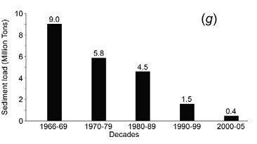
For Krishna, flows as well as suspended sediments in the delta have nearly reached zero. Suspended sediment loads decreased from 9 million tons during 1966–1969 to negligible 0·4 million tons by 2000–2005. Syvitski et al in their 2009 assessment place Krishna in the category of “Deltas in Greater Peril: Virtually no aggradation and/or very high accelerated compaction.”
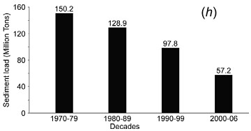
In the case of the Godavari delta, there has been almost a three-fold reduction in suspended sediment loads from 150·2 million tons during 1970–1979 to 57·2 million tons by 2000–2006. Syvistki et al classify Godavari delta as “Deltas in greater risk: reduction in aggradation where rates no longer exceed relative sea-level rise”. H Gupta et al (2012) suggest that decline in historic sediments of Godavari post damming has been as high as 74%.
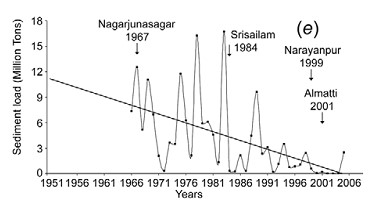
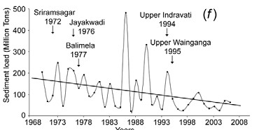
Above: Graph indicating decadal sediment and water flow trends at Prakassam Barrage, across Krishna. Dam building also marked. From Rao et al, 2010
According to Dr. Rao, a comparison of data on annual sediment loads recorded along the Krishna and Godavari Rivers shows consistently lower sediment quantities at the locations downstream of dams than at their upstream counterparts, holding dams responsible for sediment retention. Reports based on bathymetric surveys reveal considerable reduction in the storage capacities of reservoirs behind such dams. Authors say: “Sediment retention at the dams is the main reason for the pronounced coastal erosion along the Krishna and Godavari deltas during the past four decades, which is coeval[23] to the hectic dam construction activity in these river basins.”
Impacts of this can be seen in destroyed villages like Uppada in Godavari delta, destruction of Mangrove forests and shoreline. Similarly Krishna delta is losing land at the rate of 82·5 ha per year, leading to destruction of mangrove forests and loss of land.
The study concludes: “If the situation continues, these deltaic regions, which presently sustain large populations might turn out to be even uninhabitable in future, considering conditions elsewhere, such as in southern Iraq, where the farmers downstream of dams across Tigris River in Iraq, Syria and Turkey are being forced to migrate to urban centres as the reduced river flows become overwhelmed by seawater.”
I talked with Dr. Rao and asked him, if his disturbing study had any impacts. He said, no one from the administration has contacted him ever about this issue.
Above: Sediments measured at Sir. Arthur Cotton Barrage across Godavari near the Delta from Rao et al, 2010
A similar study by IWMI[24] concludes: “Coastal erosion in the Krishna Delta progressed over the last 25 years (is) at the average rate of 77.6 ha/ yr, dominating the entire delta coastline and exceeding the deposition rate threefold. The retreat of the Krishna Delta may be explained primarily by the reduced river inflow to the delta (which is three times less at present than 50 years ago) and the associated reduction of sediment load. Both are invariably related to upstream reservoir storage development.”
Krishna Basin Water Disputes Tribunal Award, though mentions dam siltation (it mentions that in 5 decades, Tungabhadra Dam has silted up to 22% of its capacity), does not say anything about flow for flushing sediments or its importance to the delta in Andhra Pradesh, or if the “minimum instream flow” recommended by the Tribunal will address this issue. This is a major limitation of the tribunal, when advanced studies have been conducted on the Krishna River delta condition and its relation to upstream dams has been established beyond doubt. Only at one place does it mention that to reduce siltation of the Almatti Dam, sluice gates should be opened when water is flowing above the crest.
However, the Award states that issues like minimum in stream flows are not decided once for all and it is an evolving process. Let us hope that there is some space to address the issue of shrinking deltas through this.
Above:Decreasing Sediments of Krishna down the years from K Rao et al, 2010
In the upstream Maharashtra, more and more dams are under construction in the Krishna Godavari Basin. One of the proposed dams called Kikvi, at the headwaters of Godavari in Trimbakeshwar was cleared by the Forest Advisory Committee recently. Ironically, the proponent (Water Resources Department, Maharashtra and Nashik Municipal Corporation) justified this dam which will submerge more than 1000 hectares of land, by stating that one more large dam close to Kikvi: Gangapur Dam is heavily silted up. [25]Rather than desilting Gangapur Dam, the administration wants to build one more dam.
Above: Trends in Sediments in Godavari and dam building activity. From K Rao et al
Many dams in Krishna Godavari Basin in Maharashtra have been criticised for not contributing to increasing irrigation.[26]These dams are not only obstructing river flow, but are also acting as sediment traps. Unfortunately, the MoEF is not even considering impacts of sediments while appraising dams. In Karnataka, major projects are being undertaken by fraud, without environmental appraisal, violating Environment laws, [27]similarly in Andhra Pradesh, many projects are being pushed illegally without environmental appraisal and which involve huge corruption[28].
2. Cauvery Delta: Although detailed studies have not been carried out, there is a clear indication of salt water intrusion and delta erosion in this over developed basin, due to upstream dams. The saline-freshwater boundary map indicates a steady migration inland.
A study by Gupta et al, 2012, indicates that historical sediment flux of Cauvery was 1.59 million tonnes, which is now 0.32 million tonnes (average of 10 years) and hence, there is a whopping 80% reduction in sediment flux of the river.
Unfortunately, the Cauvery Water Disputes Award Tribunal between Karnataka and Tamilnadu does not even mention the word ‘sediment’ in its award. There has been no justification for 10 TMC feet (Thousand Million Cubic feet) water recommended by the Tribunal for Environmental purposes and its possible impact on sediment carrying (or even environment for that matter).
Pennar showed 77% reduction and Mahanadi showed 67% reduction in amount of silt reaching the delta in recent years. (Gupta et al, 2012)
3. Narmada Delta: The west flowing rivers like Narmada and Tapi do not form extensive deltas like the east flowing rivers. Nonetheless, sediments from a huge river like Narmada play an important part in the stability of Narmada delta and villages and ecosystems around it.

Above: From: H. Gupta et al, 2007 and 2012
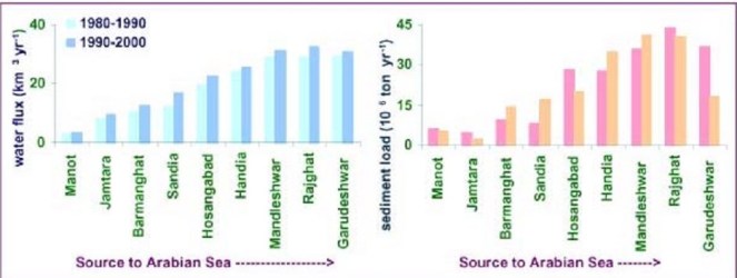
Gupta et al (2012 and 2007) assessed daily water discharge and suspended sediment load data measured by CWC at two gauging stations, one upstream of the Sardar Sarovar dam (Rajghat), and another downstream of the dam (Garudeshwar).
Historical sediment discharge of Narmada was found to be 61 million tonnes and the current sediment discharge (average of last ten years of the study) was found to be 3.23 million tonnes, indicating a reduction of 95% sediment discharge.[29] The presence of dam reduces 70–90% of coarse and approximately 50% of medium-sized particles on their way downstream, allowing them to settle in the reservoir Comparative studies of average suspended sediment load at various locations on the Narmada River for more than two decades, show overall reduction in suspended sediment load in the river.
The study indicated 96% reduction in suspended silt flux in Sabarmati, 41% reduction in Tapi and 68% in Mahi.
4. Ganga- Brahmaputra Delta: Different studies put different values for individual and combined sediment load of the Ganga Brahmaputra system, which carries one of the highest sediment loads in the world. According to Islam (1999)[30] Ganges and Brahmaputra rivers in Bangladesh transport 316 and 721 million tonnes of sediment annually. Of the total suspended sediment load (i.e. 1037 million tonnes) transported by these rivers, only 525 million tonnes (c. 51% of the total load) is delivered to the coastal area of Bangladesh and the remaining 512 million tonnes are deposited within the lower basin, offsetting the subsidence. Of the deposited load, about 289 million tonnes (about 28% of the total load) is deposited on the floodplains of these rivers. The remaining 223 million tonnes (about 21% of the total load) is deposited within the river channels, resulting in aggradation of the channel bed at an average rate of about 3.9 cm/yr sediment.
Across the 20th Century, Syvitski et al suggest about 30% reduction of silt load in the river system. Gupta et al [31] suggest that the observed decrease in sediment load could be due to construction of several mega dams in the Ganga basin, closure of Farakka barrage (1974) and diversion of sediments laden water into the Hooghly distributary. They also caution that dams in Ganga and Brahmaputra can worsen the situation.
5. Indus Delta: Inam et al (2007) assessed annual sediment loads of the Indus river at Kotri Barrage (270 km upstream from river mouth) during the last 73 years. The study indicates that annual sediment load of the Indus river has reduced drastically from 193 Mt (between 1931 and 1954) to 13 Mt (between 1993 and 2003). According to them, construction of three large dams on the Indus river, namely Kotri Barrage, Mangla and Terbela led to this situation causing annual water discharge to reduce from 110 km3 to 37 km3, with disastrous impacts on the delta ecosystem and population.
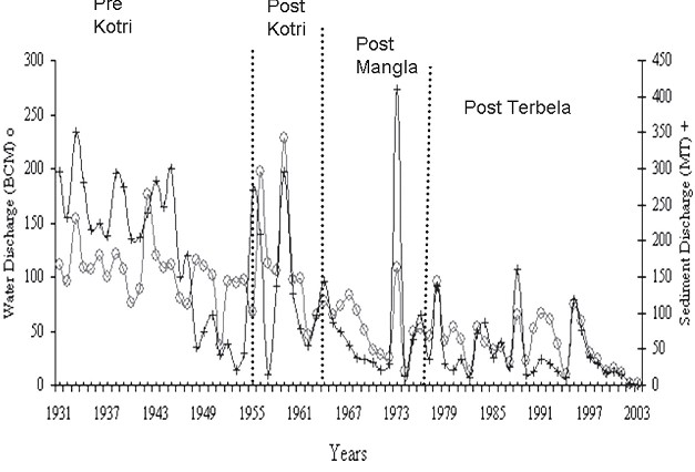
Above: Variation of water and sediment discharge below Kotri Barrage in Indus basin: Inam et al

Inam states : “Currently the Indus river hardly contributes any sediment to the delta or Arabian Sea.The active delta is reduced from 6200 km2 before construction of dams to 1200 km2. The sea water has travelled upstream upto 75 kms, combined loss of freshwater and sediment has resulted in loss of large areas of prime delta agricultural land and submergence of several villages in the coast. This has caused desertification and displacement of several hundred of thousands of local residents. Study of records and bathymetric maps from 1950 indicate widespread coastal retreat…The life on the delta is dependent on availability of freshwater and sediment. Severe reduction of both as a result of dams and barrages and associated structures in the upstream has resulted in pronounced erosion in parts of the delta and reduction in mangroves. Environmental studies to be extended to the entire Indus ecosystem from the mountains to the Arabian sea.”
Conclusions
- It is clear that deltas and dependent populations and ecosystems have suffered due to near total ignorance about the impact of dams on sediment and deltas and if immediate action is not taken then, this will impact a huge population and a large eco-region in Indian subcontinent, as elsewhere.
- The impacts of nutrient rich sediment retention and flow reduction is not limited to teh delta, but has also affected marine fish production[32]
- The issue of impact of a dam on the sediment regime of the river is not being studied or considered at all while conducting Environmental Impact Assessments of projects, appraising the project for options assessment, environmental clearance, cost benefit analysis or through post clearance monitoring and compliance.
- Sediment release and sediment transport through rivers is not being raised in trans-boundary river negotiations.
- Looking at the severity of the issue and its far reaching impacts on millions of people in India and across the world, there is a need for adopting urgent and strong mitigation measures against sediment trapping in dams.
- It has to be remembered that for older dams, older hydropower projects and most irrigation projects, there is no mechanism available to flush the accumulated silt.
- Sediment retention also reduces the life of the dam, while starving the river and delta in the downstream of sediment. As per a study by SANDRP in 2006, India may be losing 1.95 Billion Cubic Meters of Storage capacity of its reservoirs annually.[33] This implies that the rivers are losing at least that quantity of sediment annually.
The frantic dam activity in Indian Himalayas at this moment will have a serious impact on Ganga Brahmaputra Delta in India and Bangladesh and Indus Delta in Pakistan. There is an urgent need to, firstly, acknowledge these links, assess the impacts, include them in cost benefit and options assessment, address the issues and implement mitigation measures, where relevant, abandon the projects where impacts are unacceptable projects unviable.
In case of the Ganga Brahmaputra delta, recent studies have indicated that the main source of sediment in the river is the Himalayas[34]. Of the entire sediment load of Ganga catchment (This study assumed it to be 794 million tonnes/year), 80+/-10 % comes from High Himalayas and 20+/-10 % comes from Lesser Himalayas.
Bumper to bumper dam/ hydropower project building is occurring in almost all of the Himalayan states in India, which is poised to make Indian Himalayas most densely dammed region in the world. All of these dams are located in the downstream of the Greater and straddling Lesser Himalayas and can together have a tremendous impact on Ganga’s sediment load. Uttarakhand is planning and building nearly 336 Hydroelectric projects,[35]while Sikkim and Himachal Pradesh too are building hundreds of hydro projects. Arunachal Pradesh intends to dam most of its rives to produce hydropower.
No studies on impact of these projects on sediment regime of the rivers are being carried out for; neither does the MoEF insist that projects will not be cleared unless such studies are carried out. Even Cumulative impact assessments are not assessing this aspect.
Some stark examples:
The Cumulative Impact Assessment Report of the Upper Ganga Basin in Uttarakhand [36](where more than one hundred dams are planned and under construction back to back) was doen by IIT Roorkee. This cumulative impact assessment did not study any cumulative impacts due to reduced silt load of the river following major dam push.
The Lohit Basin Study done by WAPCOS[37]which involves more than 12 dams across the Lohit River, one of the three main segments that form Brahmaputra, does not mention anything about impacts of dams on sediments. The only thing it states is very worrying : “Due to substantial storage capacity, the Demwe Upper reservoir will have high sediment retention capacity and a large proportion of sediments carried by the Lohit River will get settled in the reservoir.”
Siang Basin Study [38](by RS Envirolinks Pvt Limited), which involves three mega dams across the main stem Siang, completely obliterating free flowing stretches in the river,in addition to 42 hydropower dams, does not mention anything about sediment regime, although being specifically asked to address this issue by the Expert Appraisal Committee, Union Ministry of Environment & Forests (MoEF).
1500 MW Tipaimukh Mega Dam near Bangladesh Border, which has received Environmental Clearance from MoEF does not study the impacts of sediment retention on downstream Bangladesh, and this concern has been raised by the groups in that country. The Environment Management Plan of this project which can submerge 25000 hectares of forests does not even mention the word “sediment”.
The bumper to bumper dam building activity in Himachal Pradesh in Satluj, Beas, Chenab and Ravi [39]rivers will have a major impact on silt load reaching the Indus river Basin and the Indus Delta in Pakistan. However, none of the EIAs or EMPs mention any impact of the dams on the sediment regime of the river.
In conclusion, although the risks of delta subsidence, effective sea level rise and its impact on a huge population and ecosystems has been established, these risks are being entirely ignored in the current governance surrounding rivers and deltas.
National Centre for Sustainable Coastal Management It is unfortunate to see that MoEF’s National Centre for Sustainable Coastal Management, supported by MoEF and World Bank does not allude to this issue or raise it through any publications.[40] In conversation with SANDRP, Director R. Ramesh said that the center may look at these issues in the future. However, its publications on National Assessment of Shoreline Changes on Tamilnadu and Odisha[41] do not mention upstream dams, although robust evidence exist that Cauvery delta and Mahanadi, Brahmani and Baitarni deltas are eroding due to sediment retention. Let us hope this institute will try to highlight the impact of dams on deltas with the seriousness it deserves.
Recommendations
1. Urgently study impacts of sediment retention by dams on delta population and ecosystems: MoEF, Ministry of Rural Development and Urban Development should conduct an in-depth study to understand the scale of the problems and the extent of affected people and ecosystems due to sediment impoundment by upstream dams.
2.Urgently study the optimal level of sediments (and water regime) needed for stabilising deltas and reducing subsidence.
3. Urgently institute a study to assess the extent of sediment and flows needed to be released from upstream dams and feasibility of such releases on regular basis, mimicking the river’s hydrograph. Where dams have sluice gates, these should be opened in monsoons where feasible, to allow sediment flushing. Even in dry and stressed river basins like Colorado in the United States, such high releases for redistributing sediments have been conducted in the 1990s and again in 2013 with proper planning and impact assessment.[42]
4. In Krishna and such other basins, where delta subsidence, coastal erosion and related impacts like salinity intrusion and storm surges has reached serious proportions, specifically problematic dams should be considered for decommissioning.
Environmental Appraisal Process
- Study of impact on sedimentation and siltation should be a part of the environmental impact assessment, environmental appraisal and clearance process.
- There should be a separate section in EIA for e-flows and sedimentation studies. Similarly such studies should be mandatory part of cumulative impacts, carrying capacity and basin studies.
- More dams in basins which support large deltaic populations and those having significant impacts of sediment retention by reservoirs should not be cleared.Let us hope that this chronically neglected issue receives the attention it deserves. Delta subsidence and ESLR due to upstream damming again highlights the complex and interconnected nature of the riverine ecosystem. The environmental governance in India ( as also South Asia) surrounding rivers has been treating rivers with an extremely piecemeal approach. It is clear that with the herculean challeneges we face now, such an approach is no longer affordable.
~~~~
…especially in the part called Delta, it seems to me that if the Nile no longer floods it, then, for all time to come, the Egyptians will suffer – Herodotus, History, c 442 BC (stated in Patrick McCully’s Silenced Rivers)
~~~~
-Parineeta Dandekar, SANDRP parineeta.dandekar@gmail.com
For PDF file of this blog, see: https://sandrp.in/Shrinking_and_sinking_delta_major_role_of_Dams_May_2014.pdf
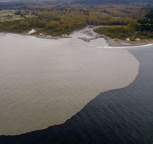
Above: Sediment laden waters of River Elwha reaching the coastal waters after Elwha Dam Removal. From: gallery.usgs.gov
Bibliography
Patrick McCully, Silenced Rivers: The Ecology and Politics of Large Dams, Zed Books, 1996
Islam et al, The Ganges and Brahmaputra rivers in Bangladesh: basin denudation and sedimentation, Hydrological processes, 1999
R.J. Wasson, A sediment budget for the Ganga–Brahmaputra catchment, Current Science, 2003
B Hema Mali et al, Coastal erosion and habitat loss along the Godavari Delta Front: a fallout of dam construction (?), Current Science, 2004
Syvitski et al, Impact of Humans on the Flux of Terrestrial Sediment to the Global Coastal Ocean, 2004
Jason P. Ericsson, Charles J. Vörösmarty S. Lawrence Dingmanb,2Larry G. Ward Effective sea-level rise and deltas: Causes of change and human dimension implications, 2006
Michel Meybeckve et al Sea-level rise and deltas: Causes of change and human dimension implications
Inam et al The Geographic, Geological and Oceanographic Setting of the Indus River, Wiley and Sons, 2007
Walling et al, The Changing sediment loads of world’s rivers, Annals of Warsaw University of Life Sciences, 2008
Syvitski et al, Sinking deltas due to human activities, Nature Geoscience, 2009
Gamage et al. Do river deltas in east India retreat? A case of the Krishna Delta, Geomorphology, Volume 103, Issue 4, 15 February 2009
K Nageswar Rao et al Impacts of sediment retention by dams on delta shoreline recession: evidences from the Krishna and Godavari deltas, India, Earth surface processes and landforms, 2010
James Syvitski et al, Sediment flux and the Anthropocene published 31 , doi: 10.1098/rsta.2010.0329 369 2011 Phil. Trans. R. Soc. A, January 2011
H Gupta et al , The role of mega dams in reducing sediment fluxes: A case study of large Asian rivers, Journal of Hydrology, 2012
IPCC, WGII AR 5:
Chapter 5: Coastal Systems and Low Lying Areas
Chapter 18: Detection and attribution of Impacts
Chapter 24: Asia
References
[1] http://www.anthropocene.info/en/home
[2] Syvitski et al 2009
[3] H Gupta et al , The role of mega dams in reducing sediment fluxes: A case study of large Asian rivers, Journal of Hydrology, 2012
[4]Walling and Fang (2003), Vörösmarty et al., 2003; Syvitski et al.,(2005), Erisson et al, (2005), Walling (2008)
[6] The role of mega dams in reducing sediment fluxes: A case study of largeAsian riversHarish Guptaa,⇑, Shuh-Ji Kaoa,b, Minhan Daia
[7] Sediment flux and the Anthropocene James P. M. Syvitski and Albert Kettner January 2011, published 31 , doi: 10.1098/rsta.2010.0329 369 2011 Phil. Trans. R. Soc. A
[8] Effective sea-level rise and deltas: Causes of change and human dimension implications
Jason P. Ericsona, Charles J. Vörösmartya,b,1, S. Lawrence Dingmanb,2Larry G. Ward
b, Michel Meybeckve Sea-level rise and deltas: Causes of change and human dimension implications Jason P. Ericson a,⁎, Charles J. Vörösmartya,b,1, S. Lawrence Dingmanb,2Larry G. Ward b, Michel Meybeck
[9] Walling and Fang (2003), Vörösmarty et al., 2003; Syvitski et al.,(2005), Erisson et al, (2005), Walling (2008)
[10] Syvitski et all 2009
[11] Sinking deltas due to human activities, Syvitski et al, 2009, Nature Geoscience
[12] Sinking deltas due to human activities, Syvitski et al, 2009, Nature Geoscience
[13] Ericsson et all, 2006, Effective sea-level rise and deltas: Causes of change and human dimension implications
[14] Sinking deltas due to human activities, Syvitski et al, 2009, Nature Geoscience
[15]Syvitski et al 2009
[16]Syvitski et all 2009
[17] Harish Guptaa, et al The role of mega dams in reducing sediment fluxes: A case study of large Asian rivers
[18] http://delta.umn.edu/content/ganges-brahmaputra-meghna-gbm-delta
[19] http://www.iisc.ernet.in/currsci/apr252003/1041.pdf
[20] K Nageshwar Rao et al, 2010, Impacts of sediment retention by dams on delta shoreline recession: evidences from the Krishna and Godavari deltas, India Earth surface processes and landforms
[22] K Nageshwar Rao et al, 2010, Impacts of sediment retention by dams on delta shoreline recession: evidences from the Krishna and Godavari deltas, India Earth surface processes and landforms
[23] Time period or age
[24] Do river deltas in east India retreat? A case of the Krishna Delta Nilantha Gamage Geomorphology, Volume 103, Issue 4, 15 February 2009, Pages 533–540
[26] http://www.civilsocietyonline.com/pages/Details.aspx?194
[29] Gupta et al, 2012, The role of mega dams in reducing sediment fluxes: A case study of large Asian rivers, Journal of Hydrology
[30] Islam et al, The Ganges and Brahmaputra rivers in Bangladesh: basin denudation and sedimentation, 1999, Hydrological processes
[31] Harish Gupta et al, The role of mega dams in reducing sediment fluxes: A case study of large Asian rivers, Journal of hydrology, 2012
[32] Drinkwater et al 1994
[33] https://sandrp.in/dams/reservoir_siltation_in_india0906.PDF
[34] R.J. Wasson, A sediment budget for the Ganga–Brahmaputra catchment, Current Science, 2003
[36] http://www.sandrp.in/hydropower/Pathetic_Cumulative_Impact_Assessment_of_Ganga_Hydro_projects.pdf
[37] https://sandrp.in/rivers/Lohit_Basin_Study_by_WAPCOS_A_mockery_of_e-flows_and_cumulative_impacts.pdf
[39] http://infochangeindia.org/environment/analysis/bumper-to-bumper-dams.html
[41] http://ncscm.org/sites/default/files/odisha_factsheet.pdf
