(Feature Image: Anti dam graffiti on the wall of the civil secretariat building in Itanagar, Arunachal Pradesh in July 2022. Source: Social Media)
Large Hydropower projects have bleak future as number of reports this week suggest, including the following Video. The large hydro is not renewable, sustainable or green or people friendly. In fact, it is increasingly seen as invitation to disasters. Much better options exist. In the changing climate situation, the destruction that hydropower projects bring about becomes even more relevant when we need the Rivers, Forests, the biodiversity and less disaster prone options. Earlier our governments see this writing on the dam walls from across the world, better it will be for all concerned.
Feature image: A Hindu woman worships the sun god in the polluted waters of River Yamuna during Chhath Puja in New Delhi, on Nov. 14. (Image Source: Quartz India.)
In its latest report, the National Green Tribunal (NGT) appointed monitoring committee overseeing Yamuna River cleaning progress in Delhi says that the river is “fighting to stay alive” and it would not be possible to rejuvenate the Yamuna unless minimum environmental flow is provided as it is “virtually reduced to a trickle and remains dry in some stretches for almost nine months of the year”.
In the action plan, it is mentioned that “Although the Yamuna river flows only for 54 kilometres from Palla to Badarpur through Delhi, the 22 km stretch from Wazirabad to Okhla, which is less than 2 per cent of the river length of 1370 km from Yamunotri to Allahabad, accounts for about 76 per cent of the pollution level in the river”.
The committee has suggested that a team of scientists be formed from CPCB, DPCC and other institutions like IIT Delhi or NEERI to carry out inspections and submit reports to it for remedial action. The team can look into the risks and benefits of an alternative way of routing the same quantity of water which can help in reducing the pollution level, it said.
The monitoring committee also raised objection to the capacity utilisation of common effluent treatment plant (CETP) which is as low as 25 per cent. There are 28 industrial clusters in Delhi and 17 of these are connected to 13 CETPs. The remaining 11 clusters are not connected to any CETP. Another area of concern is the direct discharge of completely unregulated waste from industries and residences into the river.
Wetlands can be defined as lands transitional between terrestrial and aquatic eco-systems where the water table is usually at or near the surface or the land is covered by shallow water.
But they are threatened by reclamation and degradation due to activities like drainage and landfill, pollution, hydrological alteration (water withdrawal and changes in inflow and outflow), over-exploitation resulting in loss of biodiversity and disruption in ecosystem services provided by them.
Similarly, despite country’s space agency ISRO had in 2011 mapped over two lakhs of wetlands across the country, the centre has, so far, notified only 115 wetlands and 63 lakes in 24 states and 2 UTs for conservation and management.
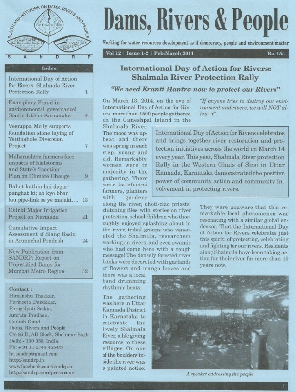
The February – March 2014 edition of SANDRP’s magazine ‘Dams, River and People’ is now available online. This is the 1st-2nd issue of magazine in its 12th volume. The contents magazine is mentioned in the list below. This edition of the magazine covers varied but very significant issues related with dams, rivers and environment in India. This issues brings together detailed reports on a river protection rally in Western Ghats, blatant violation of environmental laws for construction Yettinahole Diversion Project in Karnataka, impacts of hailstorm on Maharashtra farmers and state’s ‘Inaction’ plan on climate change, a reality check on Narmada Kshipra pipeline project in Madhya Pradesh and a detailed critique of cumulative impact assessment study of Siang river basin in Arunachal Pradesh. The magazine in pdf format is available here — https://sandrp.in/DRP_Feb_Mar_2014.pdf. Several of the articles are also available in SANDRP’s blog and they can be viewed just by clicking on the name in the list. Enjoy reading.
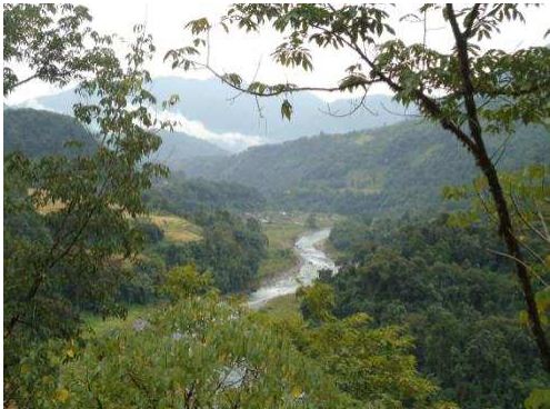
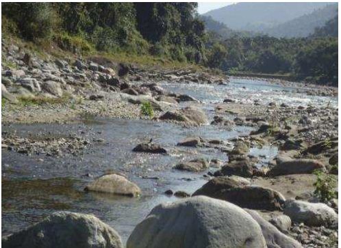
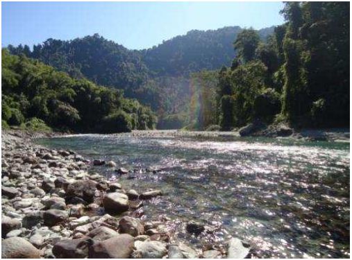
The Simang River is a tributary of the Siang River which originates at an elevation of 2950 m. The river is 44 km long (as mentioned in the EIA/EMP reports done by consultant R S Environ Link). Total catchment area of Simang River is 554 sq km. There are two projects proposed on the Simang River. The first one is Simang I with an installed capacity of 67 MW (3 x 22.33 MW) and catchment area of 494 sq km. The second one is the upstream project Simang II with an installed capacity of 66 MW (3 x 22 MW) and catchment area of 422 sq km. These two projects were jointly discussed in the 19th meeting of EAC in October 2008 for the first time. Then these projects were subsequently discussed in the 21st, 36th, 66th and 67th meeting of EAC. A diagram of the two projects on the Simang River is given below.
Diagram of Simang I & II projects on Simang River
Troubled Figures of EIA/EMP
In order to prepare the above diagram EIA/EMP reports of both Simang I and Simang II has been consulted. A detailed analysis of the numbers and figures mentioned in the EIA/EMPs for the river shows serious inadequacies in both the EIAs and raises questions on the authenticity of the EIA studies being done on the river.
1. EIA Wrong about Length of Simang River: It is surprising to find that the EIA studies for the two projects cannot give the correct the length of Simang River and contradicts each other (e.g. paragrapgh 4 page 1.14 of EIA of Simang I). Even though the total length of the river has been mentioned as 44 km in EIA studies of both the projects, lengths of the river over different parts do not add upto that.
The EIA report of Simang I in map of ‘Figure 1.3: Project in Simang Basin’ of page 1.16 shows that the distance between the origin of the river and reservoir of Simang II HEP is 22.27 km. The EIA report of Simang II states that the distance between barrage axis of Simang II and Simang-Siang confluence is 19.66 km (paragraph 1 page 5.2). The stretch of the Simang River used by Simang II barrage is 1.05km (from page 4.6 paragraph 1 & 2 of Simang II EIA report). If we take the total of these three parts of the Simang River, the total length of the river will be 42.98km and not 44 km.
On the other hand if we take some other figures given for different parts of the river, then we get another length for the Simang River. The Simang I EIA shows that the distance between the barrage axis of Simang II and TWL of Simang I is 15.75 km (Figure 1.3). The distance between the TWL of Simang I and it’s confluence with Siang river is given as 3.29 km. From this the total length of the river comes out as 41.31 km excluding the Simang II reservoir area. The stretch of the Simang River used by Simang II reservoir is 1.05 km. So including this total length of the Simang River is 42.36 km, not 44 km.
This is a serious inadequacy on the part of the EIA studies since the studies are not clear even about the river length across different parts of the projects. Either the EIA consultants do not know the rivers or they are fudging figures. In either case, these EIA reports should not be accepted.
2. Incorrect Assessment of River Use for the Projects The EIA reports of both Simang I and II projects gives incorrect figures for stretch of river used for the projects. The stretch of the Simang River submerged by Simang II barrage is 1.05 km (from page 4.6 paragraph 1 & 2 of Simang II EIA report), stretch of river bypassed between Simang II barrage and TWL is 7.75 km. The EIA report of Simang I states that the stretch of river submerged by Simang I barrage is 1.48 km and stretch of river bypassed between Simang I barrage and TWL is 7 km. This concludes that the total length of the river used by the two projects is 17.28 km and not 15.75 km as claimed in the EIA reports. Not giving the correct information about the stretch of the river used for projects is a major lacunae on the part of the EIAs and hence these EIA should be rejected.
3. Incorrect Assessment Distance between Simang-Siang Confluence and Power House of Simang I: It seems the EIA/EMP consultant has no knowledge of the area since the distance stated between the Simang-Siang confluence and Power House also seems to be incorrect. The Simang I EIA in states that distance between barrage axis of dam and Simang-Siang confluence is 9.34 km. It also stated that the distance between barrage axis and power house is 7 km. This leaves the distance between the Simang-Siang confluence and Simang I power house as 2.34 and not 3.29 as shown in Figure 1.3 in page 1.16 of the EIA. This again proves that the EIA report prepared by the consultant is inadequate and it should not be accepted.
4. Assessment of river length for diversion is doubtful The diverted river length for Simang II HEP given as 7.75 km in the EIA seems to be doubtful. But tunnel lengths mentioned in the same document for Simang II are as follows:
Tunnel
Length (km)
HRT
7.4
Surge Shaft
0.017
Pressure Shaft
0.225
Penstock
0.056
TRC
0.202
Total
7.9
In fact the bypassed length of the river is likely to be longer than this length of the various tunnel components since rivers do not flow in straight lines, unlike the tunnels.
Critical Issues Not Addressed by EIA/EMP The projects on the Simang River were first considered for TOR in 2008 in the 19th EAC meeting. The proposal that time was to construct three hydro electric projects (HEPs) on the river. In reply to this the EAC had asked, “Secretary (Power) and Secretary (Environment) of Government of Arunachal Pradesh should attend the next meeting to clarify the reason for allotting a series of hydroelectric projects on a river which subsequently flows only through tunnels and damage the aquatic ecology.” The Power secretary and Environment secretary attended the 21st meeting of EAC. Going through the minutes of that meeting, it becomes very obvious that Arunachal with its aim to generate more revenue was ready to dam every river or stream in the state. This strengthens the impression that the Simang I or Simang II HEPs are not going to be much beneficial for the local people, environment or the state.
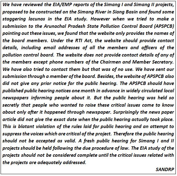
After going through the EIA/EMP of both the projects we have found that there are several critical issues with these studies. There are several issues which are common in both the studies and several others which are particular to each project. Reading these documents thoroughly gives a feeling that the documents don’t have much of a difference from each other and lot of ‘copy-pasting’ has been done. Some of them are also mere replications (e.g. section 4.2 page 4.7 of Simang I EIA and section 4.1.8 in page 4.6 Simang II EIA). There are also many instances where names and words have been confused, e.g. in page 1.15 of Simang II EIA, in the title of the Table 1.1 “Simang I” has been mentioned instead of “Simang II’. This kind of issues raises question on the validity and authenticity of the EIA/EMP studies done. Some of the critical issues are listed below as an example, this is not exhaustive list.
1. EAC Recommendations not Followed: The EIA/EMP studies of these projects have not followed several of the EAC recommendations. EAC in its meetings had recommended the project proponent to address several important concerns but those were no followed.
“To maintain the aquatic life, a study to be conducted by National Institute of Hydrology, Roorkee. Methodology followed for measurement of water flow to be given.” (19th EAC Meeting) – There is no mention of any study done on environment flows. The EIA/EMP report of both the projects does not give any details of how the environment flow was measured except mentioning what will be the environmental flow.
Between dam and power house how many streams/ tributaries join and what is their contribution in turn of water in the lean season and monsoon? (19th EAC meeting) – The EIA/EMP of none of the two projects responded to this. There are no accurate details about number the flow contribution of different streams or river joining Simang.
Seismic Studies, Slope Stabilization measures, Reservoir Rim Treatment should be included in the EIA/EMP studies. (36th EAC meeting) – The EIA/EMP studies of the two projects do not have any details ofseismic studies done in the project area.
Disaster Management Plan should be included in the EIA/EMP studies. (36th EAC meeting) – This is very surprising because none of the two projects in Simang River has any disaster management plan in their respective EIA/EMP documents.
Pareng Village located in the upstream of Simang I barrage Siteand near the power house of power house site Simang II HEP. Source: EIA/EMP report of Simang I & II
2.Impact of Migration of Outside Workers on Local Communities not Assessed The EIA/EMP reports estimates that there will be migration of nearly 1000 persons for each project during the peak construction period to this very sparsely populated area. People who live in this area belong to several ethnic tribal groups with unique social, economic, political and cultural values. The EIA/EMP reports do not discuss what will be the impact of such migration on the social, political, economic and cultural lives of the people. Influx of such migration will also have impacts on their human rights as well on women. The EIA/EMPs make no mention of these impacts of migration and that is why the EIA/EMP report is incomplete. Besides, even though the projects had been considered together by EAC, no cumulative impact assessment of migration was done.
3. Shoddy Socio-economic Impact Study: The property surveys which the consultant claim to have done for both these projects are inadequate and shoddy socio-economic impact assessment studies. For Simang I a property survey of project affected families in 5 villages was done but it was found incomplete since it does not take into account two of the project affected villages. On page 6A-10 of the EIA report, these 5 villages are stated as Dosing, Lileng, Pareng, Rengo and Boleng. But out of these villages, there are only three villages mentioned in the property survey – Pareng, Rengo and Boleng. The two villages Dosing and Lileng were not found in the list and instead there were two different villages mentioned in the list – Yingku and Sine.
But after reading through the EIA study of Simang II, it becomes clear that project consultant had done only one survey for both the projects. The two villages Yingku and Sine are also found in the property survey list for Simang II EIA with the same number of affected families (page 6A-16).
It is also surprising to see how the opinions can be exactly similar for both the projects when the affected families are different for each project (See page 16A-15 of Simang I HEP EIA and page 16A-17 of Simang II HEP EIA). Besides, in the list mentioned in page 6A-17 of Simang II EIA, village named Yingku is mentioned twice but there is no justification provided for that.
This brings to light how recklessly these EIAs had been prepared. In fact, the whole concept of property survey is questionable. It takes into account very limited concerns related with the projects ignoring many serious issues. One important aspect of what is the value of the river and other common property resources for the people of the area finds no mention in the property survey. Such property survey cannot be taken as a full proof socio-economic impact assessment and hence EIA/EMP is incomplete and cannot be accepted.
4. Options Assessment not Done The EIA/EMPs of the proposed projects have not done any options assessment study. For example, the option of sub megawatt micro hydro project for a sparsely populated and pristine area like this has not been assessed. For ethnic tribal communities with small population micro hydro project is a better option. The option of solar power generation has also not been assessed by the EIA/EMPs of the projects. Options assessment is an important part of the EIA/EMP document and since this is not done the EIA/EMP reports are incomplete and cannot be accepted.
Intermediate zone near Sine Village between barrage and power house of Simang II Source: EIA report Simang II
5. Environmental Flows Assessment not Done: The EIA/EMP reports of the two projects do not give any detail of how environment flow was calculated and how environment flow will be released. We have already mentioned that in the 19th EAC meeting, EAC had suggested that in order to maintain the aquatic life, a study should be conducted by National Institute of Hydrology, Roorkee and the methodology followed for measurement of water flow should be made available in the EIA. But there is no mention about any such study in any of the documents.
EIA reports of both projects mentioned about the environment flow release exercise but that should have been done already and should have been a part of the EIA. Since the EIA reports do not mention about any study done on environment flow as asked by the EAC this EIAs cannot be taken as a complete impact assessment.
6. Socio-Economic Impacts of Reduced Flow Ignored: None of EIA/EMP reports mention about the socio economic impacts of reduced flow in the intermediate stretch between the barrage axis and power house. Besides, in questionnaire of the primary survey/property survey which the EIA consultants claim to have done, there is no question on impacts of the reduce flow of water in the river. Besides, the EIA/EMP studies do not discuss the importance of the river for the local people. This proves that EIA report is inadequate and cannot be accepted.
Power house site of Simang II HEP Source: EIA report of Simang II
7.Impacts of Non-monsoon Peaking Power Generation not Assessed: EIA/EMP reports of the two projects do not assess how peaking power generation during non-monsoon period will impact the flow in the river downstream from power house. Peaking power generation will have significant impact in the downstream since there will be sudden flow of water in the river for a short period of the day and rest of times it will remain almost dry. This sudden release of water holds threat for the people living downstream as well as their livestock. There are many instances where large number of people and livestock dying due to sudden release of water from upstream dam. Most recently, on Oct 7, 2013, one person was washed away in Arunachal Pradesh due to sudden release of water from the Ranganadi HEP.[1] Besides, this fluctuation in river water on everyday basis will have severe impacts on aquatic bio diversity of the river and use of the river by the people. EIA study ignores all these issues and that is why this study cannot be accepted as a complete study.
8. Impact Assessment of changing sediment releases not Done The EIA/EMP reports do not talk about how sedimentation will impact the reservoir. The EIAs should have included detail analysis of two main impacts – 1.Impact of changing silt flows downstream from desilting chamber and 2. Impacts of silt flushing in monsoon season on the downstream areas. The EIA/EMP report should also do a cumulative study of reservoir sedimentation because the sediment released from the upstream reservoir will affect the reservoir downstream.
9. Socio-economic Impact Assessment of Quarrying not Done: EIA/EMP of any of the two projects on Simang does not talk about the socio economic impact of quarrying on the local people and environment. EIA/EMP reports also have not assessed how the quarrying in a fragile hill range like Eastern Himalayas will increase the risk of landslide and disaster. Ignoring the disaster risk of quarrying in the hills can have disastrous impacts and the recent Uttarakhand disaster is a proof of that. Since EIA/EMP studies ignore all these issues, they cannot be accepted as complete and that is why EIA/EMPs of Simang I and II should be rejected.
10. False Claim about Height of the Dam: The claim made by the EIA/EMP of both the projects that 18 m high dam reservoir is “very low height” is misleading and false. In the 2nd paragraph of page 10.2, the EMP report of Simang I states “Because it is a run of the river hydro project with a small barrage with very low height (18 m), the inundation will be minimized during reservoir filling.” The same claim has been made in the same page of Simang II EMP. This claim is baseless because according to international standards any dam with a wall height of 15 m or above is a big dam.
11. Climate Change Assessment Not Done EIA/EMP studies of both the projects have not done any climate change impact assessment for the proposed projects. Today when climate change impact risks are increasing day by day, it is very essential for studies like these to do an assessment of possible climate change impacts on the project as well as impacts of the projects on local climate. In fact the word “climate change” is nowhere to be found in the EIA or EMP of the two projects. Without climate change risk assessment, an environment impact assessment cannot complete and that is why this report is unacceptable.
The EIA/EMP studies should also have done an assessment of methane release from the reservoir of the project. Since these important issues are not addressed by the impact assessment study, it cannot be accepted as a complete study.
12. False Claims about Flora and Fauna The EIA/EMP of the two projects makes a completely baseless claim that “There will be no negative impact on flora of region during the operation phase.” This cannot be accepted as truth since during the construction phase of Simang I and II, the forest area diverted will be 29.86 ha and 22.02 ha respectively. After such a diversion forest, the impact on flora and fauna is inevitable because the area is covered by dense forest. The EIA report of Simang I states that forests constitute the predominant land use in the 10 km area which was studied for this project and 67.66% of this area is covered by dense forests. Besides, none of the two EIA studies provide any data on how many trees will be cut down for the project. These are serious lacunas on the part of EIA/EMP of these two projects and that is why this report cannot be accepted as a comprehensive study.
14. Barrage Location not Clearly Stated for Simang I The EIA report of Simang I is not clear about where the barrage of proposed Simang I HEP will be located. In page 1.5 the EIA report states “The reservoir created by the barrage located near Boleng town will operate between FRL 339 m and MDDL 334 m.” But the same report in page 5.2 says “The proposed Barrage axis is situated about 9.34 Km upstream of confluence of Simang river with Siang river. The river Simang joins the SiangRiver near Boleng township.” Besides, the maps show that Boleng area is located near the confluence of two rivers not near the barrage site. This is a significant error of the EIA study and hence this study is inadequate and cannot be accepted.
Barrage site Simang I HEP Source: EIA report of the Project
15. Simang II does not assess the project impact on Protected Area EIA states that the distance between Mouling National Park and the reservoir tail at Subbung Nala and Simang River are 5.6 and 5.7 km respectively (page 1.2, paragraph 2). Being in so close proximity of a protected area there should have been impact assessment of the project on the protected area but the EIA/EMP does not mention any such assessment.
16. Threat to Nearly Threatened Mammals The Simang II HEP is a threat to some of the endangered mammal species listed in IUCN Red List. Common leopard (Panthera pardus) and Assamese macaque (Macaca assamensis) which falls in the “Near Threatened” and Gaur (Bos frontalis) falling in “Vulnerable” category of IUCN Red List are found in the project area of Simang II. There are 13 more species of mammals falling under the “Least concern” category of IUCN which are also found in the area. This has been stated in the EIA study of Simang II.
On the other hand, the EIA study of Simang I ignores some the species falling under IUCN Red List. Rhesus macaque, Indian Porcupine and Asiatic Brush Tailed Porcupine which are found in the area fall under the “Least concern” category of IUCN Red List but the EIA report completely ignores this.
The EIA/EMP reports of the two proposed HEP projects on Simang River have significant lacunas and those cannot be ignored. The EIA consultant also had not consulted the local people in preparing the EIA report. This is another significant lacuna on the part of the EIA because it is the local people who are more aware of the local environment and river as they have lived in that place for generations. It is shameful that on the basis of such studies and reports, public hearing for the two HEPs was held without even announcing the Public hearing dates on the AP Pollution Control Board website. If these dams are constructed on the basis of such shoddy reports and flawed public hearings then it will invite an uncertain future for the people of the area and people have to live at the risk of disaster. The EAC should consider these issues seriously and must not accept these reports. The EAC should also consider recommending the black list of the consultants for the serious lacunae in the reports.


")


 The Simang River is a tributary of the Siang River which originates at an elevation of 2950 m. The river is 44 km long (as mentioned in the EIA/EMP reports done by consultant R S Environ Link). Total catchment area of Simang River is 554 sq km. There are two projects proposed on the Simang River. The first one is Simang I with an installed capacity of 67 MW (3 x 22.33 MW) and catchment area of 494 sq km. The second one is the upstream project Simang II with an installed capacity of 66 MW (3 x 22 MW) and catchment area of 422 sq km. These two projects were jointly discussed in the 19th meeting of EAC in October 2008 for the first time. Then these projects were subsequently discussed in the 21st, 36th, 66th and 67th meeting of EAC. A diagram of the two projects on the Simang River is given below.