डॉ जैकब स्टीनर, पोस्टडॉक फेलो भूगोल और स्थानिक अनुसंधान संस्थान, ग्राज़ विश्वविद्यालय, ऑस्ट्रिया (jakob.steiner@uni-graz.at) और अमृत थापा, डॉक्टरेट छात्र, फेयरबैंक्स विश्वविद्यालय अलास्का (aamritjnu@gmail.com) द्वारा एक त्वरित जोखिम आकलन रिपोर्ट। इस रिपोर्ट का अंग्रेजी अनुवाद यहाँ देखें।
Continue reading “पिंडर घाटी उत्तराखंड: कुंवारी में भूस्खलन निर्मित बांध के संभावित खतरे “Tag: Landslide dam
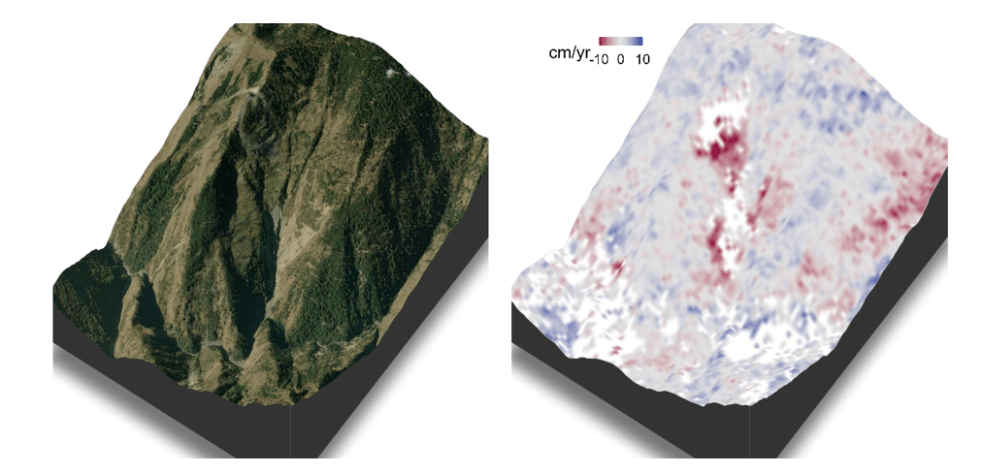
Pindar Valley, Uttarakhand: Potentially Dangerous Landslides Dam in Kunwari
A Rapid Hazard Assessment Report by Dr Jakob Steiner a postdoc fellow at the Institute of Geography and Spatial Research, University of Graz, Austria (jakob.steiner@uni-graz.at) and Amrit Thapa a doctoral student at University of Alaska Fairbanks (aamritjnu@gmail.com). A Hindi version of this report can be seen here.
Continue reading “Pindar Valley, Uttarakhand: Potentially Dangerous Landslides Dam in Kunwari”
DRP 300821: Why no protection for aquatic biodiversity?
(Feature image Wildlife Along Indian Rivers by Green Humour:- http://www.greenhumour.com/2017/09/wildlife-along-indian-rivers.html)
Aquatic freshwater biodiversity has seen the maximum decline over the years and yet has the least protection under law. In fact fish is not even considered for protection under the Wildlife Protection Act. Fishing cat, Mahseer, Otters, Trout fish, Hilsa fish are all at top of the food chain in freshwater sources, like the tiger is in the forests, but none of them have the legal protection. If we have any serious intension of protecting this important source of biodiversity, we urgently need measures, including policy, legal and institutional measures to recognize and protect this biodiversity.
Continue reading “DRP 300821: Why no protection for aquatic biodiversity?”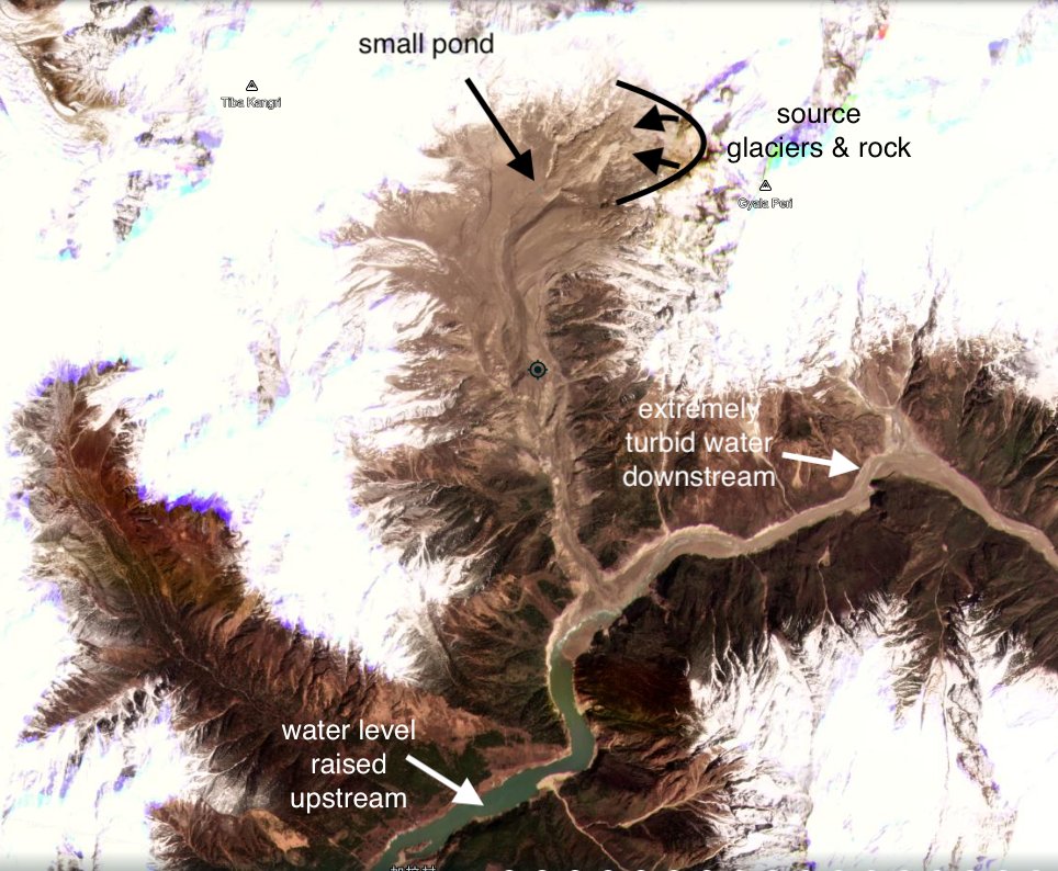
Massive Landslide on Yarlung Tsangpo on March 22, 2021
Dave Petley has on March 29, 2021[i] reported that a massive landslide has occurred along Yarlung Tsangpo river in Tibet, just upstream of Great Bend. (coordinates: 29.815, 94.932, the centre of the landslide source.)
Continue reading “Massive Landslide on Yarlung Tsangpo on March 22, 2021”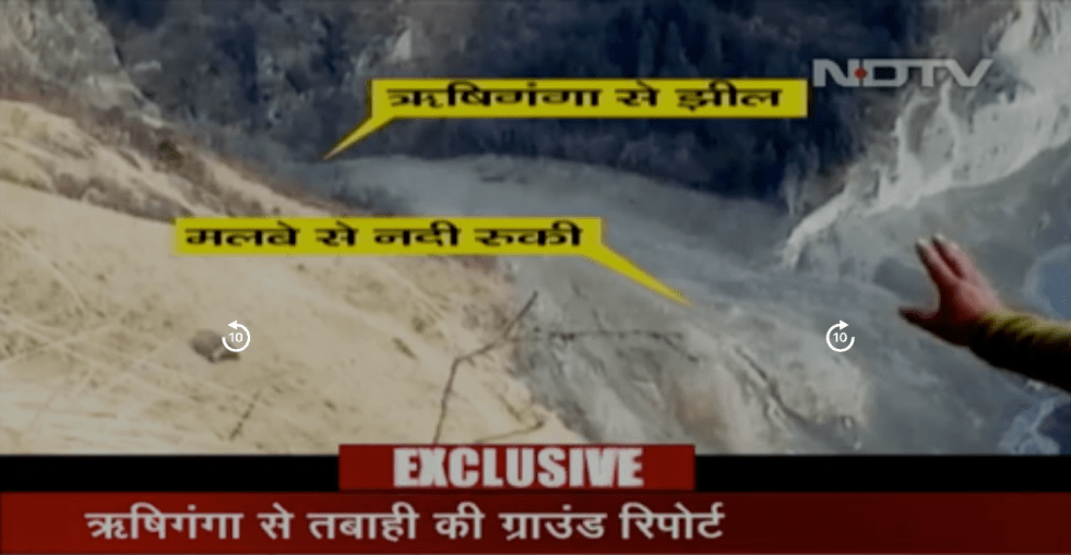
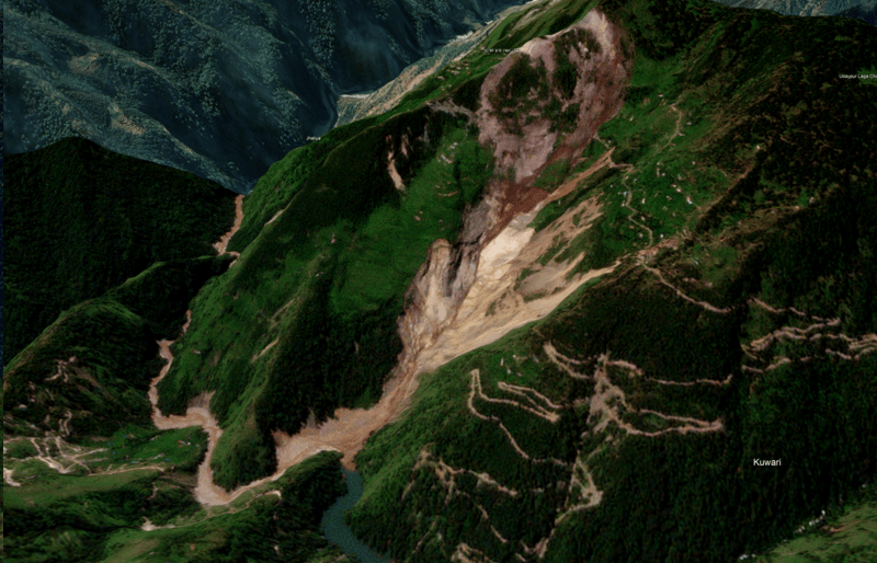
Rishiganga Ground visit report reveals landslide dam & raises questions
The first ground visit report of the Rishiganga catchment in Uttarakhand’s Chamoli district by Dr Naresh Rana, a geologist after the Chamoli Avalanche disaster of Feb 7, 2021 has been shared by NDTV on Feb 11, 2021[i]. Dr Rana visited the catchment of the Rishiganga to understand the ground situation on Feb 10 ,2021 and this is possibly the first such visit since the disaster.
Continue reading “Rishiganga Ground visit report reveals landslide dam & raises questions”
DRP: 5 Nov 2018: More Reports on Failure of Namami Gange Program
(Feature image showing preparation of Kumbh 2019 at Prayagraj by Siddharth Agarwal of Veditum)
EDIT article in SCIENCE magazine by TUSHAR SHAH and others on Ganga: “The quickest, cheapest, and most effective way for Mr. Modi to show a less polluted Ganga by 2019 would be operating dams and barrages in the Ganga basin with the sole objective of augmenting river flows. This would be a start to controlling discharge of untreated sewage and industrial waste, which will take a long time.” http://science.sciencemag.org/content/362/6414/503 (2 Nov. 2018)
DOWN TO EARTH says about Ganga: “the river will continue to run as – and even more – polluted as ever… Till August 31, 2018, only a little more than a quarter of the total number of projects sanctioned under it (Namami Gange) had been completed… according to CPCB’s Water Quality Map, only five out of the 70-odd monitoring stations on the river had water that was fit for drinking; only seven had water that was fit for bathing…”
-“Down To Earth quotes a study report and CPCB data to say that the actual measured discharge of wastewater into the Ganga is 123 per cent higher than what has been estimated…”
-“Numerous hydroelectric projects on the Bhagirathi and Alaknanda have turned the upper stretches of the Ganga into ecological deserts, says the Down To Earth assessment. The baseflow amount of the river has decreased by a huge 56 per cent in 2016, as compared to the 1970s.”
– “about 180 MLD of sludge will be generated in the five Ganga Basin states (Uttarakhand, Uttar Pradesh, Bihar, Jharkhand, West Bengal) when they become ODF. If proper sludge management is not done, this would invariably pollute the Ganga. What should cause further concern is that faecal sludge is a bigger pollutant than sewage – while BOD of sewage is 150-300 mg/litre, that of faecal sludge would be 15,000-30,000 mg/litre.” https://www.cseindia.org/ganga-may-not-flow-clean-in-the-near-future-says-new-analysis-9085 (30 Oct. 2018)
Meanwhile, a new CAG report reveals that almost 26 million litres of untreated sewage still flows into the Ganga every day in Uttarakhand. https://www.downtoearth.org.in/news/water/uttarakhand-has-failed-to-rejuvenate-the-ganga-through-namami-gange-62027 (2 Nov. 2018)
Continue reading “DRP: 5 Nov 2018: More Reports on Failure of Namami Gange Program “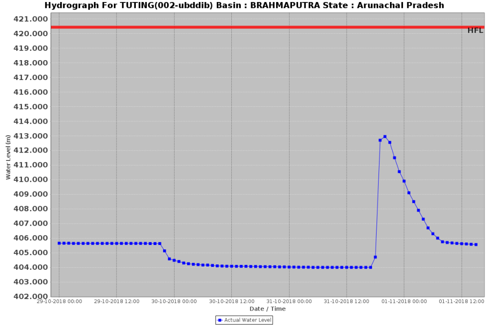
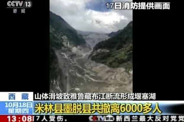
Another Landslide Dam on Yarlung Tsangpo raises more questions
On Oct 29, 2018, another landslide dam blocked the path of Yarlung Tsangpo Dam, reportedly at the same location as the Oct 17,2018 landslide dam[i]. It breached on Oct 31, without any reported major calamity, but these repeated occurrences, twice in two weeks and third time in ten months (if we include Dec 2017[ii] landslides) raises a lot of questions. The silence of government of India institutions about the possible causes or other analysis, including by Central Water Commission, Union Ministry of Water Resources, National Disaster Management Authority or even National Remote Sensing Agency has, as expected, raised questions and speculations in Arunachal Pradesh. Continue reading “Another Landslide Dam on Yarlung Tsangpo raises more questions”
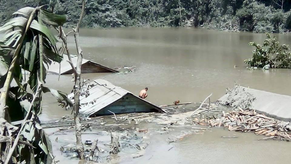
Landslide DAM on Tsangpo creates flood disaster risk for Siang
A massive dam, created by landslide in early hours (around 5 am) of Oct 17,2018 has blocked the main stream of Yarlung Tsangpo in Tibet. The reservoir behind the dam already has humungous 360 Million Cubic Meters (MCM) of water by 7 am on Oct 18, 2018 and as per latest reports (subsequently saw the CWC tweet put out at 955 pm on Oct 18, saying that storage had reached 484 MCM by 8 pm on Oct 18), the reservoir is still growing in size. The exact location of the landslide dam is uncertain. According to one source, the latitude longitude could be 94.93754° E, 29.74957° N, but this may not be accurate the likely location may be a few kilometers downstream from here. The Chinese media[i] has reported that the landslide dam is located at near Gyalha village in Milin or Manling county. According to some experts who visited the site, the dam could breach very soon, possibly on Oct 19, bringing massive floods along Siang river in Arunachal Pradesh. Continue reading “Landslide DAM on Tsangpo creates flood disaster risk for Siang”

Landslide Dam on Sonam River in Uttarkashi: Threat to people and structures in the downstream area
Above: Landslide Dam over Sonam River in Uttarkashi Dist in Uttarakhand (Photo from Jagran.com)
A landslide on Sonam river (Bhagirathi basin) in Bhatwari block in Uttarakashi district in Uttarakhand has blocked the flow of the river and created a lake about 90 m long, 80 m wide and 1.5-3 m deep. The landslide dam in Nelong valley in Jadhganga river basin about 145 km from Uttarkashi town, apparently was formed due to landslide during cloud burst on July 27, 2016, but the information about it reached the administration only on Sept 4, 2016, 39 days later. The landslide dam, about 24 km from the India China border has created a threat to the downstream river bank communities, roads and bridges and other structures and also ecology. The reservoir has been formed at the confluence of Angar Nallah, a local stream, with Sonam River. A team of officials sent by the District Collector on Sept 5, 2016 has submitted a report, but the report is not yet in public domain. Continue reading “Landslide Dam on Sonam River in Uttarkashi: Threat to people and structures in the downstream area”
TEESTA LANDSLIDE DAM IN DZONGU: RIVER OVERFLOWS OVER DAM BUT RISK CONTINUE
Above: Submerged houses in reservoir behind landslide dam. Photo from Darjeeling Chronicle
The Kanaka River is flowing over the dam that was created on Aug 13, 2016, it is confirmed now, but the risk of the dam failure and disaster downstream continues. In the meanwhile, the upstream villages, cut off due to road damaged and bridge submerged, are facing serious problems.[i] Continue reading “TEESTA LANDSLIDE DAM IN DZONGU: RIVER OVERFLOWS OVER DAM BUT RISK CONTINUE”
