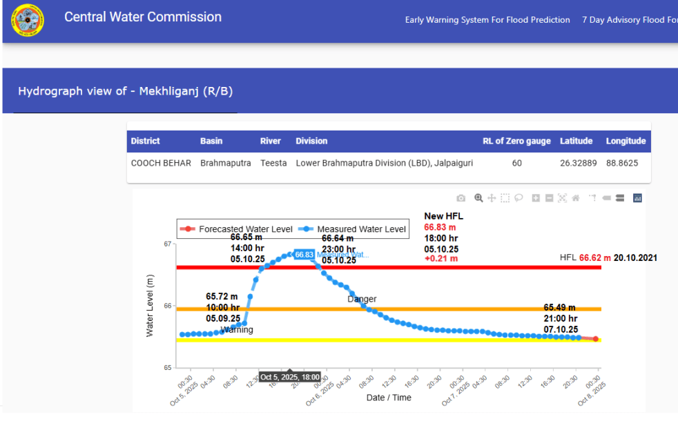
In Oct. 2025, we could find at least 06 flood monitoring sites of Central Water Commission (CWC), where rivers have crossed their Highest Flood Levels (HFL) after the end of South West Monsoon season 2025 on Sept 30 2025. Of the 6 sites, 2 each are in Brahmaputra basin in W Bengal and Ganga basin in Bihar. 1 site Anantharam on Musi river in Telangana is part of Krishna basin and 1 site Marella on Gundlakamma river in Andhra Pradesh is part of East Flowing Rivers between Mahandi and Pennar basin.
Continue reading “India’s Rivers in Extreme Floods in Oct 2025”Tag: Ganga Basin
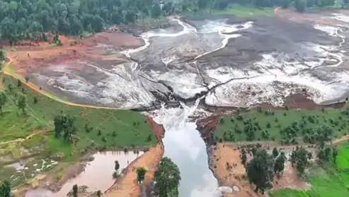
Sept. 2025: Six Killed in Luti Dam Flood Disaster in Chhattisgarh
(Feature Image: Damaged Sadsa Luti dam in Balrampur)
A flash flood disaster caused by a significant breach in Luti dam bund has killed six people while one remained missing in Dhaneshpur village near Vishram Nagar under Balrampur district of Chhattisgarh. Six of the flood victims are members of a single family living about 500 meter downstream from the dam area. About eleven villagers were swept away by strong current of waters. Some of them managed to save their lives by holding on to trees and swimming to their safety. Three persons also suffered injuries in this dam induced flood incident.
Continue reading “Sept. 2025: Six Killed in Luti Dam Flood Disaster in Chhattisgarh”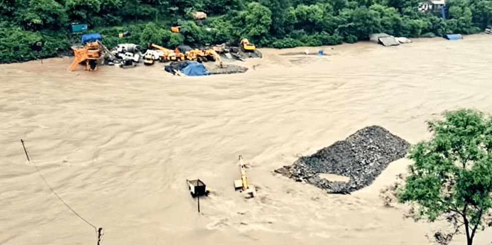
Aug 2025: Flood Affects Satpuli Barrage Project in Uttarakhand
(Feature Image: Flooded machines, camps and materials of Satpuli lake project on Aug 06 morning. Credit: Chain Singh Rawat (Junyali), Satpuli)
A flood spell in Nayar river (East) on Aug 6, 2025 morning has affected the ongoing construction work of Satpuli Barrage Project in Pauri district of Uttarakhand. The flood submerged some machines, heavy vehicles, worker camps and huge amount of construction materials, leading to huge losses for the construction company. All these machines, materials and camps were in the riverbed and flood zone of the river, exposing them to flood threats in the peak monsoon.
Continue reading “Aug 2025: Flood Affects Satpuli Barrage Project in Uttarakhand”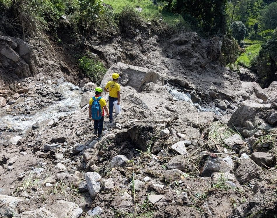
Aug 2025: Five Road Workers Missing After Flashfloods in Pauri-Uttarakhand
(Feature Image: Search Operation on Aug 07, 2025 in Katola gaad of Bankura village in Chauthan Patti, Thaisain, Pauri. Source: Uttarakhand Police)
The Chauthan Patti under Thailisain block of Pauri Garhwal district in Uttarakhand has again been battered by excessive rainfall events on August 06 2025. Villagers have reported of 3 incidents of ‘cloudburst’ induced flashflood causing severe damages in Bankura, Mansari and Sarson villages.
Continue reading “Aug 2025: Five Road Workers Missing After Flashfloods in Pauri-Uttarakhand”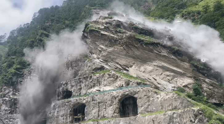
Aug 2025: Rockslide at Vishnugad-Pipalkoti in Uttarakhand
(Feature Image: Rockslide at dam site of 444 Mw Vishnugad-Pipalkoti HEP on Aug 02, 2025)
At least 12 workers sustained injuries in a rockslide at the under construction Vsihnugad-Pipalkoti Hydro-Electric Power (VPHEP) project in Chamoli district of Uttarakhand. The 444 Mw (111X4) project is being built on Alaknanda River by the Tehri Hydro Development Corporation (THDC).
Continue reading “Aug 2025: Rockslide at Vishnugad-Pipalkoti in Uttarakhand”
The Sad State Of These Persons Called Ganga & Yamuna – Can State Protect Them?
Guest Blog by: Chicu Lokgariwar
It’s a girl! And another girl!
On March 20 2017, the High Court of Uttarakhand in an unforeseen move, bestowed ‘legal personhood’ on the Ganga and the Yamuna. Ten days later, as people were still trying to understand the implications of this order, the Court declared the glaciers, lakes, and wetlands of these basins as legal persons. What does this mean exactly?
The decree: As per an order passed on 20th March 2017, while ruling on a public interest litigation filed by Mohammed Salim against the State of Uttarakhand, the High Court has declared the entire length of the Ganga and the Yamuna, including their tributaries to be juristic persons.
The order states, ‘..the Rivers Ganga and Yamuna, all their tributaries, streams, every natural water flowing with flow continuously or intermittently of these rivers, are declared as juristic/legal persons/living entities having the status of a legal person with all corresponding rights, duties and liabilities of a living person in order to preserve and conserve river Ganga and Yamuna.’
Continue reading “The Sad State Of These Persons Called Ganga & Yamuna – Can State Protect Them?”

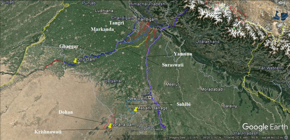
Haryana Rivers Profile: (Part-II – Ganga Basin)
Yamuna Basin: River Yamuna[1] accounts for 7.10 % of the total geographical area of the country. The Haryana state forms 6.5%[2] of the river basin. It drains an area of 366,223 square km in the Gangetic plain and constitutes 40.2% of Ganga Basin. The river annually carries 10,000 cubic billon meters (CBM) of water of with 4400 cbm is used for irrigation. Yamuna river basin forms the upper sub-basin of Ganga river[3] the total area of which is 35798.19 square km comprising of 47 water sheds.
Yamuna river originates from Bandar Punch glacier in Uttarkashi district of Uttarakand. The river flows through about 200 kilometers before reaching Haryana State at Shivalik Hills in Yamuna Nagar district. In the same district the river is trapped in Hathini Kund Barrage located in Kalesar National Park.
Continue reading “Haryana Rivers Profile: (Part-II – Ganga Basin)”
Haryana Rivers Profile: (Part-I – Indus Basin)
India is a land of several great rivers[1]. Haryana[2] the 20th Indian state has also been enriched by numbers of rivers, streams and rivulets. These rivers only strike public discourses during monsoon when they flood human habitations although pollution and sand mining incidents are routinely covered. Moreover there is no Government Department in the State which is in control or possession of complete information on the rivers of the State, as the various State Government Agencies in limited manner deal with specific issues affecting the rivers and there are Government Agencies also whose plans or projects impact the rivers in adverse manner. This two part blog report from SANDRP strives to present a picture on the rivers of Haryana. The State is broadly divided by two basins: Indus and Ganga. This first part of the blog mainly focuses on rives which are part of Indus basin. The second part will bring information of other rivers in the State which join the Ganga basin. Apart from putting together the basic facts, the blog series also highlights the key issues and present day status of these river systems.
Continue reading “Haryana Rivers Profile: (Part-I – Indus Basin)”
