Karnataka is still reeling from the protests, rasta roko, bandhs, burning effigies, etc., resulting from the anger over the Interim Verdict of Mahadayi Water Disputes Tribunal[i] (MWDT) of the 27.07.16 which did not allow Karnataka’s Appeal to temporarily lift 7 TMC (Thousand Million Cubic Feet) water from Mahadayi Basin into Malaprabha Basin (a sub basin of Krishna basin). Twin cities of Hubali and Dharwad, likely beneficiaries from the diversion, are centers of agitation. Schools and colleges were closed, government offices and buses were burnt, major roads were blocked by protesters. Pro-Karnataka Organizations and even Film stars have joined this protest. Karnataka Home Minister has called on the Prime Minister to look into the decision. Goa, on the other hand, is quietly celebrating this one positive step[ii]. I was reminded of Rajendra Singh’s uncritical support to the project and also what Dr. T V Ramchandra from IISC, Bangalore said about this, “Do the film stars know the details of the issue or even where their water comes from? The day we push Pudharis away, solutions to our water woes will be easy and closer to home.”
I have returned from Mhadei/Mandovi Basin recently, tracing her footsteps near her origin to the sea and it is difficult to conceive that this veritable treasure trove of serenity and beauty is today a bone of contention, leading to unrest and violence. Continue reading “Mahadayi Water Disputes Tribunal: Trouble brewing in Paradise”→
Multiple Dams for Mumbai Region have severe impacts and are unjustifiable
More than 50 people including tribal groups, social activists, water experts, ecologists and wildlife experts, academics came together for a brainstorming workshop about Dams coming up for Mumbai Region. The meeting was organized by South Asia Network on Dams, Rivers and People, Shramik Mukti Sangathana, Jalbiradari and Keystone Foundation.
About 12 dams are planned or are under construction to satisfy the increasing thirst of the Mumbai Metropolitan Region (MMR). All of these dams fall in eco-sensitive region of the Western Ghats. They will together submerge more than 22,000 hectares of land, including nearly 7000 hectares of forests, lakhs of trees and more than 750 hectares of Tansa Sanctuary. They will affect a minimum of 100,000 tribals who depend on the forests and their ancestral lands for livelihoods. These dams include Kalu, Shai, Balganga, Susari, Khargihill, Bhugad, Pinjal, Gargai, Middle Vaitarna, Barvi and Poshir, among others. These are in addition to the dams already constructed for MMR water supply.
Tribals and other affected groups of Thane and Raigad region have been strongly opposing these projects. Most people in Mumbai seems unaware of their struggles or impacts of these projects.
Most of these dams are escaping the social and environmental impact assessments and management plans, environment clearance requirements, environmental monitoring or public consultations due to blunders in environmental impact assessment notification of Sept 2006, which excludes domestic and industrial water supply projects from environmental clearance process.
MMR has not done any sort of options assessment before pushing these projects and cursory review show that many options exist. At the city or Region level, there is no shortfall in water supply currently and the existing problems are due to inequitable, non-transparent, non-participatory and wasteful water governance in MMR. Municipal corporations under the MMR which are pushing new dams do not treat even 15% of their sewage. Bhiwandi Nizampur & Vasai Virar Corp do not treat ANY of their sewage. The Mumbai Region has no estimate of its rainwater harvesting potential, and there is little effective action in this direction despite high rainfall. Water supply and distribution losses are over 30%. Local water sources like rivers, lakes and wells are being destroyed by pollution and encroachments. There is no interest in democratizing governance of MMR water sector.
We urge the MMR region to address these issues first, which would lead to sustainable water supply to the city and suburbs. Konkan Irrigation Department which is constructing most of these projects has violated several laws related to tribal and forest rights, environment, forests and resettlement and has been mostly favoring a single contractor, illegally.
We strongly urge the MMRDA, MCGM, Municipal Corporations of MMR, Maharashtra government, Union Ministry of environment and forests, Maharashtra Forest Department, National Board of Wildlife and all others concerned to ensure that following steps are taken up urgently and in a credible way:
Undertake thorough options assessment for Mumbai’s (and also same for other cities of MMR) water needs which includes groundwater use, local water sources, rainwater harvesting, sewage treatment and reuse, water supply efficiency, etc.,
Undertake Environmental and Social impact assessments for all the dams coming up for Mumbai Region
Take immediate action against KIDC for violating multiple laws while bulldozing ahead with projects and MMRDA for funding projects in the absence of clearances
Respect peoples protests and Gram Sabha resolutions against displacement, deforestation and their refusal to give permission for these projects
Take strong penal action against the officers and the contractors who have displaced Adivasis illegally
Not to resume any work or planning for any project before the above is done, stop work on projects in the meantime.
Change the EIA notification to ensure that all large dams are included for environment clearance, public hearings and EIA requirements.
Immediately institute a credible Cumulative Impact Assessment of the projects already constructed and advanced in implementation.
Institutionalize decentralized, democratic governance of water sector in MMR from bottom to top.
Forests in the Western Ghats are Mumbai’s and MMR’s lungs. They are the watersheds of rivers and water sources like Tansa and Bhatsa and naturally purify Mumbai’s & MMR’s drinking water.
Rich tribal culture of Thane and Raigad is a shared heritage of Mumbai and we have no right to displace the tribals or destroy their livelihoods.
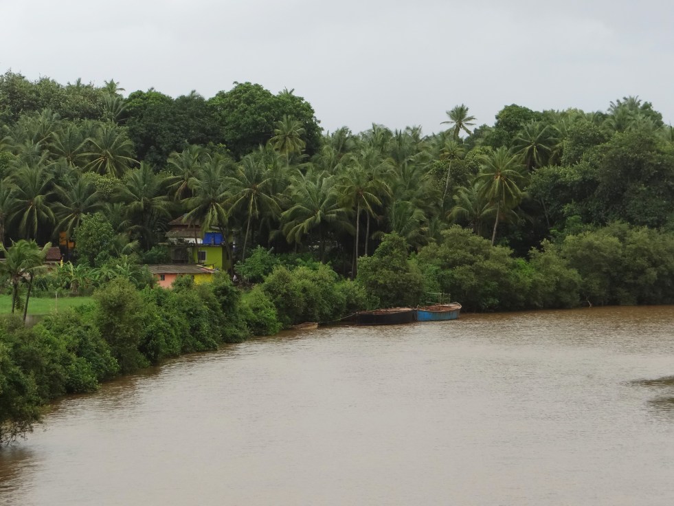
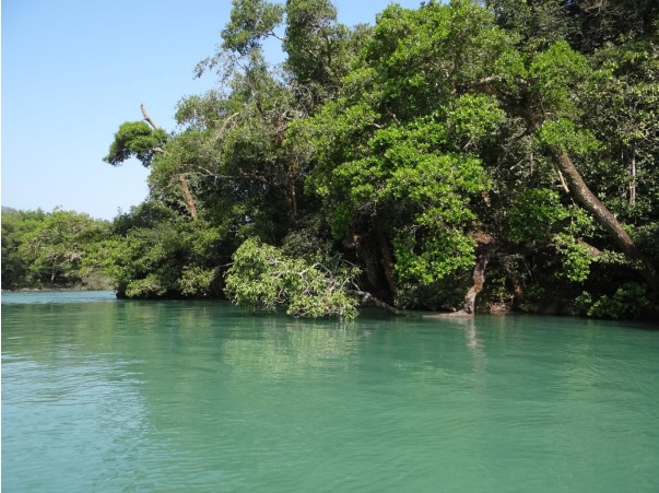
River Kali, before it enters Dandeli in Karnataka is a breathtaking sight..
Its waters are emerald green, flowing steadily. Its banks are thickly forested with a continuous canopy. Endemic species like Malabar Giant Squirrel, Malabar Pied Hornbills, Malabar Gray Hornbills are a common sight here. Down the river, a monitor lizard is stretched across a branch, low over the waters. Fishing eagles and several kinds of Kingfishers look for fish. Fisher folk hover along the banks in beautiful coracles, laying hooks in the riparian vegetation.
During our visit to the Kali, my six-year-old swam in the river and could not believe that the river back in his home-town was once as clear as this!
Emerald waters of the Kali Photo: Author
It’s hard to imagine that it was a touch-and-go for this stretch of Kali…
If it were not for some brave, timely advocacy and strong local action, most of this stretch would have been submerged. Rest of the river would have been diverted through a tunnel or silenced in a steady pool of a reservoir: the way many Indian rivers are silenced. There would have been no river, no riparian forests and possibly no swimming.
Malabar Pied and Malabar Gray Hornbills on the banks of Kali Photo: Author
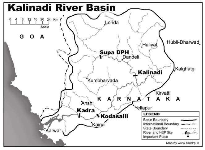
Dams on Kali: Kali has seen far too much damming. According to Kali Bachao Andolan, a network of organizations working to protect Kali River, more than 5 dams across the river have already submerged 32,000 acres of forests in the Western Ghats. According to Karnataka Power Corporation website, “The west flowing Kalinadi has its origin at an elevation of 900 m, near the DiggiVillage in the Western Ghats of Karnataka. Its 180-km long journey ends at the Arabian Sea near Karwar.”
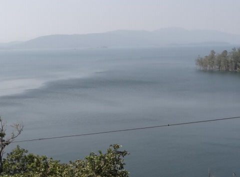
After its origin, it’s dammed at Supa in Joida Taluk of the Uttara Kannada District. The submergence of Supa Dam is a site to behold. Stretching endlessly like an ocean, this dam submerged more than 24 villages and hundreds of hectares of forests. One of the dam evictees, an old, frail man now tells me, “Even now in summers, when the waters recede, I can see my village and my temple. We try to go there some times. I can see all my past life there, for a brief period, before it all goes under water again”.
Extensive submergence of the Supa Dam Photo: Author
Downstream the 101 m-high Supa Dam (100 MW), the river flows down through Dandeli town, taking huge pollution from West Coast Paper Mills on the way. From here it is dammed at Bomanhalli Pick up Dam, from where it is diverted to Nagazhari Powerhouse (870 MW), then to Kodasalli Dam and powerhouse (120 MW) and then at Kadra Dam and powerhouse (150 MW). If we look at the flow chart of Kali Nadi Dams, the river seems to be flowing from one reservoir into the next, with nearly no free flowing river stretch between two dams. Its main tributaries Kaneri and Tatihalla have been dammed too.[1] The power generation performance of Kali dams for the last 27 years is shown in the graph above.
There is a stretch downstream the Supa dam to Bomanhalli Pick up dam, where the Kali still flows. This again is controlled flow, regulated by the Supa Dam. But this is the precise stretch which was also targeted to be dammed in 2000’s. An 18 MW project by Murudeshwar Power Corporation Limited (MPCL) was proposed to come up at Mavlangi village downstream Supa Dam. According to Kali Bachao Andolan, it would have meant submergence of 210 hectares of land, including 70 hectares of forest land, next to the Dandeli Sanctuary. Kali Bachao Andolan, including Parisar Samrakshana Samiti, Sirsi and Environment Support Group (ESG), Bangalore, highlighted that Uttar Kannada District only needed 17 MW electricity (in 2000) while it was producing more than 1200 MW electricity and one more dam at a huge social and ecological costs cannot be justified. More importantly, ESG exposed that the Rapid EIA (Environment Impact Assessment) report done by reputed consultancy Ernst and Young for the proponent, was in fact a copy-paste of a different EIA, done by a different agency for a different river! A strong campaign was built around this, which garnered public and media support.
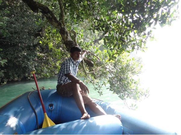
Guide from one of the homestay-resorts, a resident of Dandeli Photo: Author
In 2006, the Forest Advisory Committee of the MoEF rejected Forest Clearance for this project. The project was also strongly opposed internally within the Karnataka Government by the Department of Tourism. Surprisingly, MoEF did not book the EIA agent (Ernst and Young) or the proponent (MPCL) for submitting an entirely false report! Even more shockingly, this EIA was later done by TERI (The Energy Research Institute), which also completed the study in one month and came up with a dubious report based on secondary data. However, strong opposition from local groups, ESG, and even within Karnataka Government resulted in rejection of the proposal by a number of authorities, including the Department of Industries and Collectorate of Uttar Kannada. Since then, the project has tried to raise its head again, only to be opposed strongly.[2]
Fishing along the Kali in the early morning Photo: Author
Around 10 years down the line, what does this small stretch of free flowing river mean?
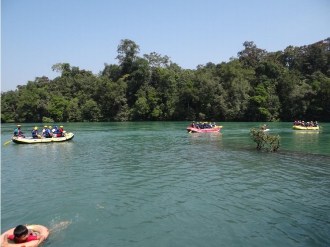
I traveled in Uttara Kannada as a tourist in November 2013. A thriving tourism industry now exists on the banks of Kali and the river is now world-renowned as one of the best rivers for white-water rafting in India. There is boating, canoeing, kayaking, swimming, fishing along this stretch of the river. Pools and islands in the river provide perfect habitats for various species as well as for naturalists and bird watchers. The range of recreational activities that take place along the river are endless. Fishermen still lay their nets across this stretch and catch some fish (though I was told that fish greatly reduced after Supa Dam was commissioned in 1985). Along the banks of the river in this stretch, a thick riparian forest flourishes, providing habitat and corridor to several species.
But more importantly, this tiny stretch is a reminder of how this great river once was. A humbling reminder.
According to Lal, now a boatman and guide from Dandeli, the river stretch which could have been dammed, now provides tourism related employment to around 1000 people from around the region. The region supports around 8 resorts and several homestays. It has created multiple employment opportunities for locals like naturalists, guides, white-water trainers, etc. Some of the locals are descendants of the Supa Dam evictees. One of them says, “The relocated colony of Supa evictees is called Ramnagara, actually it is Vanvasanagara. If it were not for the tourism, I would have migrated to Goa or Belgaon. We saw the fate of Supa dam displaced and would not allow one more dam, no matter how small or big, to affect us again.”
Many ways to enjoy a flowing river: Rafting, canoeing, swimming Photo: Author
The struggle against 18 MW mini hydel has been significant in a number of ways. EIA and public hearing for the project were the two events where protests were recorded. It was through these platforms that the extent of the impacts of the projects was known and could be opposed. However, after this, a newer version of EIA Notification was adopted in Sept 2006 which excludes hydel projects below 25 MW from its ambit! This has been a ecologically senseless move as projects which have severe impacts on the ecology do not even need a public hearing and an EIA now! We, and several experts and organizations, have raised this point a number of times with the MoEF, but MoEF is yet to respond.
One more strong point of the struggle was a more than 20-year-old order by Karnataka government categorically stating that since the Kali river is so heavily dammed (five major dams on this short 186 kilometre long river, destroying most of its forests and displacing thousands of tribal and forest dwelling communities), no more dams, big or small, shall be allowed further across this river. This has been a very significant order.
Even today, when more and more bumper to bumper dams in the Himalayas and Western Ghats are killing our rivers, our Ministry of Environment and Forests does not have a clear guideline for protecting certain stretches of rivers from dams or declaring them as no-dam stretches. There exists no such order protecting over-dammed, collapsing rivers.The only report which actually recommended that 24 dams in the Upper Ganga basin should be dropped due to their impact on ecosystems, has not been complied with by the MoEF. Dams are coming up in cascades, without leaving any free-flowing riverine stretch between two projects. Nothing is being done about this. The MoEF’s Expert Appraisal Committee on River Valley Projects now has a weak norm of leaving a bare kilometer of flowing river between projects. But this norm too gets twisted and violated.
Avay Shukla committee appointed by Himachal Pradesh High Court recommended that projects should have at least 5 kilometers of free flowing river between them. But MoEF does not seem to support this. In fact, a flowing river seems to have no value in our governance system.
However, as the Kali experience shows, a flowing river is good for ecology and is good for the people too.
Let us take this opportunity to thank the Kali Bachao Andolan and the local communities for protecting the last remaining free flowing stretch of Kali… so that we can catch a glimpse of how a free-flowing river looks like!
– Parineeta Dandekar
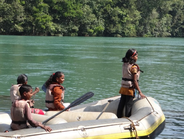
Local children rafting along the Kali Photo: Author
The Forest Advisory Committee (FAC) of the MoEF in its meeting on the 11th and 12th of July did not recommend Forest Clearance to Kikvi Drinking water project coming up in Nashik.The proposal entailed diverting 172 hectares of forest land and a massive 761.52 hectares of agricultural land, totalling 933.98 hectares, without even a rehabilitation or resettlement plan. The project proponents pushed the project claiming that Gangapur dam is being silted up, but shockingly, did not present any alternative of desilting Gangapur Dam or even mentioning that Nashik already has three more drinking water supply sources in the upstream and downstream of Gangapur Dam.
In its decision, the FAC noted that
· “The project proponent has not given due diligence in assessing water requirement of the area and available resources already in existence to meet this requirement.
· No evidence is made available to prove that an authenticated study has been conducted to assess water requirement
· There are three more drinking water/irrigation projects in Nashik but user agency could not establish any link between capacity of these and future water requirement.
· Possibility of enhancing storage capacity of Gangapur dam to its installed capacity of 7.2 TMC by way of desiltation has not been explored.
· It is also not understood how rehabilitation plan is not required if submergence of agricultural and is involved.”
FAC has asked for further clarification and reports before the project can be considered again. This includes a detailed study to assess present and future requirement of water for drinking irrigation and vis a vis available sources, an integrated plan which may include desilting study for Gangapur dam as well as a Rehabilitation and Resettlement Plan for the population whose agricultural land will be submerged. It has also asked for compliance of Forest Rights Act.
This is indeed a welcome decision by the FAC. The proposal highlighted callous and casual approach of the Nashik Municipal Corporation while diverting an entire river and affecting agricultural lands in over 10 villages in Nashik, without even mentioning agricultural submergence clearly in its application.
Through this series, will be trying to publish issues related to dams in the World Heritage site of Western Ghats. The dilemma of Conservation Vs Development of this ‘most populated biodiversity hotspot in the world’ has been highlighted with the WGEEP and HLWG Report. Through this series, we will try to look at the way in which rivers, forests and communities in the Ghats are being affected by dam construction and to what extent do these dams contribute to development of teh region whihc suffers the impacts.
1. Nardawe Dam, Sindhudurga District, Northern Western Ghats, Maharashtra
Introduction
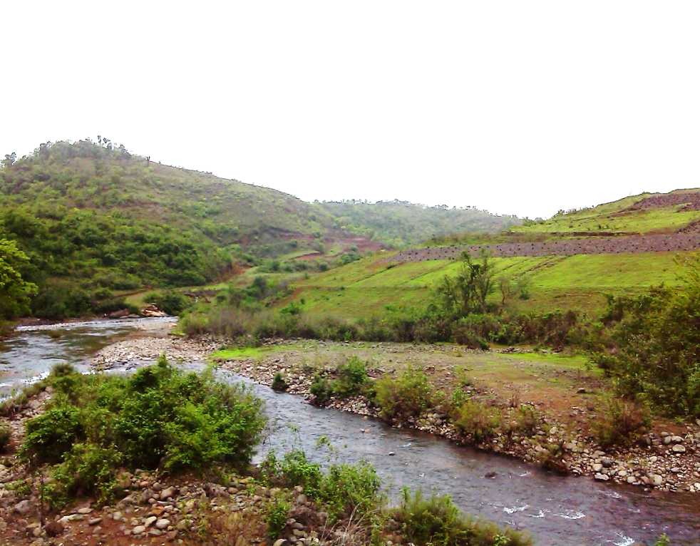
Nardawe dam is being built on GadRiver in Kanakavali taluka of Sindhudurg district by Konkan Irrigation Development Corporation (KIDC), under the Water Resources Department, Maharashtra. Gad is a small west flowing river originating from the Western Ghats, meeting the Arabian Sea. According to the White Paper on Irrigation Projects in Maharashtra brought out by the Water Resource Department (WRD) in December 2012, Administrative approval for Nardawe Dam was granted in 1989 for Rs. 32 Crores. Due to a number of delays, the project could not be started for more than a decade. By the third administrative approval in 2007, the sanctioned cost shot up to ₹ 446 Crores.
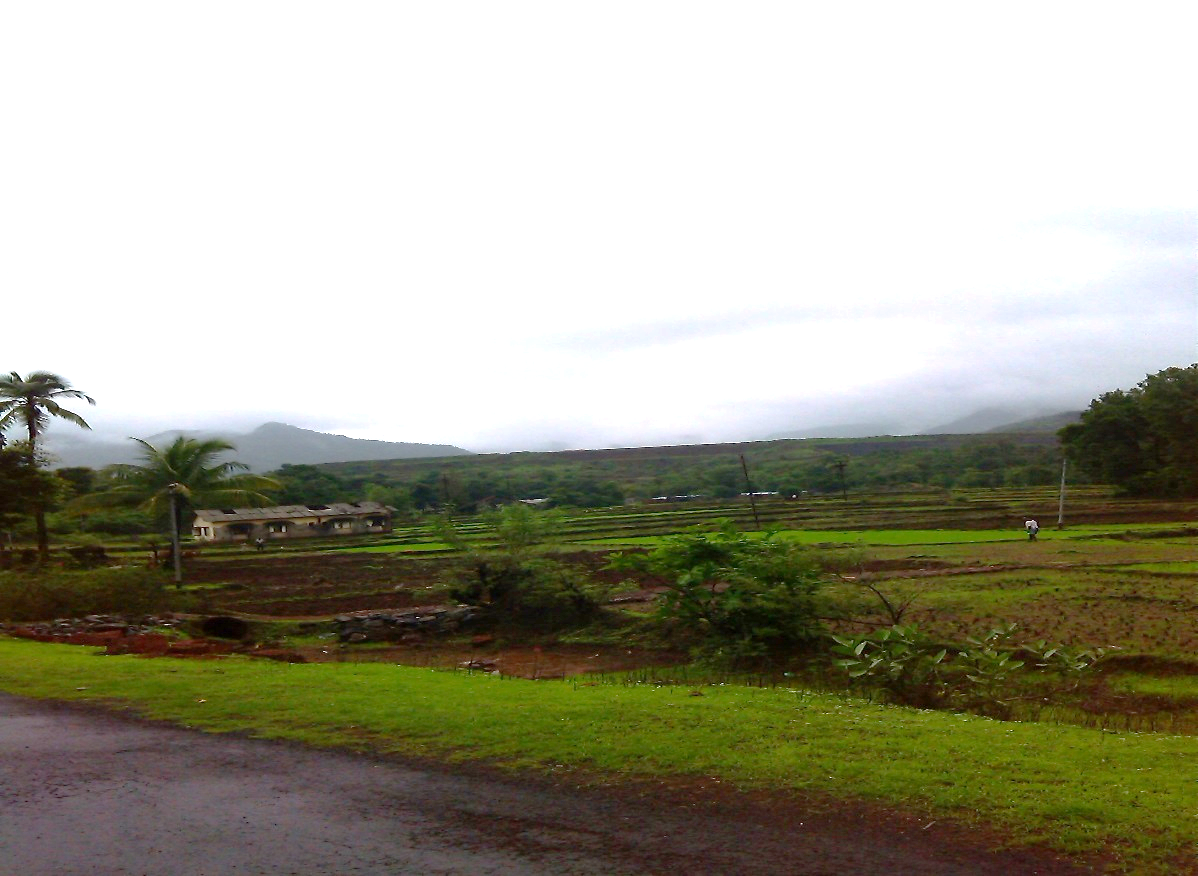
Rice sowing at Nardawe Photo: Damodar Pujari
A brief reading of the White Paper and actual situation in Maharashtra indicates that this is a typical tale of most dams, where cost and time estimates have been escalated multiple times.
By June 2012, the KIDC has spent ₹ 311 Crores on this project. Costs have escalated despite the fact that canals in the original proposal have been cancelled and converted into 16 ‘Kolhapur Type’ gated weirs (KT Weirs).Its Command area (after the dam completion) is supposed to be 12, 530 ha, through 16 KT weirs.It will store 123.74 Million Cubic Meters (MCM)water .Total submergence of Nardawe Dam is625 hawhich will affect3849 people from 967 families.1 village is completely affected (Jambhalgaon) and 4 (Naradawe, Yavateshwar, Bhairavgaon, Durganagar) villages are partially affected. 34.13 ha of identified forests will have to be diverted for the project
Actualwork on the project started in 2001.
According to white paper, 61% work on the dam is complete, which includes the earthen dam wall and 10 KT weirs.
This project finds itself mired in violations of several kinds That it is coming from KIDC comes as no surprise. This section of the WRD Maharashtra has been a regular in violating several norms while pushing its projects. KIDC was also found to have indulged in corruption in the case of Konadhane Dam in Raigad, has started work on Dams like Kalu and Balganga without Forest Clearances or rehabilitation plans.
Illegal Work without Environment Clearance The project has a command area more than 10,000 hectares and hence, requires an Environmental clearance according to the EIA Notification of 1994 which was in effect when the construction work for the dam started. Legally, work cannot start on the dam without an Environmental Clearance. In Nardawe, work has been 61% complete even without an Environment Impact Assessment or Public Hearing.
Work at Nardawe Dam. Photo; Damodar Pujari
Executive Engineer of the Project, Mr Godse, while speaking to SANDRP on the 7th July 2013 accepted that the project has just applied for Terms of Reference (TORs) with the Ministry of Environment and Forests (MoEF) and had started work without an Environment Impact Assessment, Public Hearing or Environmental clearance.
Forest Clearance The project affects 34 ha of identified forest land (वन संज्ञा क्षेत्र) and hence requires Forest clearance from Divisional Forest Office, Bhopal. It does not have final forest clearance. Violating the Forest Conservation Act 1980, work on the project went on, even in Forest area.
Work at Nardawe Dam Photo: Damodar Pujari
The Executive Engineer, while speaking to SANDRP stated that a number of queries have been raised by the Forest Office, Bhopal, one of which is that the project is in vicinity of Radhanagari Wildlife Sanctuary and may need clearance from National Board for Wildlife too.
Forest Rights Act: Individual and community Rights of people dependent on Forest areas are not yet settled. This is serious as these are private forest lands and there is a strong dependence of people on these forests.
High Level Working Group (HLWG) and Western Ghats Expert ecology Panel (WGEEP) Reports All of the affected villages fall under Ecological Sensitive Areas as per the HLWG report and entire Kanakavali Taluka was considered as Ecologically Sensitive Zone (ESZ) – I by WGEEP. WGEEP Report has recommended that no large dams should be built in ESZ 1. According to HLWG Report, peoples’ consultation and resolution are a must prior to starting work in Ecologically Sensitive Areas.
These committees were formed after work on the Nardawe Dam started. However, these reports highlight the high ecological richness of the area. If KIDC had conducted a credible Environment Impact Assessment, as it is legally bound to conduct, these issues could be highlighted before starting work. Current ecological and related social loss could have been avoided.
Officials agree to violations, say that it is more of a norm When SANDRP talked with the Executive Engineer of the project, Mr. Godse on 7th July 2013, he agreed that work on the project is in advanced stage without an Environmental Clearance or Forest clearance in place. As a justification, he said that many projects in Maharashtra indulge in these violations! He said that the project has just applied for TORs for Environmental Clearance with the Ministry of Environment and Forests’. However, the project is yet to come up before the Expert Appraisal Committee of MoEF on River Valley Projects.
Dubious role of EIA Agencies While the Executive Engineer himself agrees that the project has progressed without an Environmental and Forest Clearance in place, The EIA agency for this project, namely Science and Technology Park, Pune[i] did not bat an eyelid while agreeing to do an EIA for this project. They did not point it out to KIDC that applying for an Environmental Clearance when the work is supposedly 61% complete is illegal, neither did they refuse to be a party of such a violation. When SANDRP talked with official from Science and Technology Park involved in this work, he admitted that have visited the region and know that work is at advanced stage. He also agreed that this is a violation and there is little meaning in doing an EIA in such a case. This same agency has worked on EIA Reports of other dams in Konkan region as well.
KT Weirs instead of Canals Letter written by Upper Secretary, Irrigation Department dated 23rd November 1994, claims that the proposal of building RBC (85 km) and LBC (45 km) can generate less irrigated area compared to their length and hence appear to be inefficient in terms of cost as well as irrigation potential. The letter further asks the executive engineer to change the cropping pattern to arecanut and floricultural crops in the command area which require less water which could be supplied from gated barrages through lift irrigation. With this letter as support, canals have been cancelled and KT weirs are being installed, at an increased cost.
Abandoned site office of the Nardawe Dam at Nardawe Photo: Damodar Pujari
Issues of rehabilitation and resettlement When a survey was conducted in 1997, it concluded that 967 families were affected by Nardawe Dam. Sixteen years after the survey, villagers say that the number of affected families has grown to 1245. This means that more than 6000 people may be affected by this project. The villages where resettlement will take place are nothing but sections of hill slopes, as I saw for myself.
Figure 5. Santosh Sawant. One of the affected people and non-governmental member on rehabilitation committee at district administration level
Currently, No resettlement has taken place and villagers are not moving out of their homes.
In a bid to force the affected families out from their homes, administration has stopped construction and repairing of basic civic facilities in the affected villages since 2001.No new water connections, repairing of roads and even ZP schools has taken place in the affected villages in order to push the residents accepting lands in resettlement villages.
Response of the administration has been to assert that local opposition has been the main reason behind the delay in the project. Actually, work on the project has been going on irrespective of local protests, morchas or sit-ins, in complete disregard of the local demands and concerns.
In Conclusion According to villagers, KT weirs built downstream the dam are largely unused because of the cropping pattern, which depends mainly on monsoon and availability of groundwater. Before the KT weirs too, the river was used for some seasonal irrigation.
Time and again it has been proved that major and medium irrigation projects are not a solution for Konkan’s agriculture. According to the White Paper, while the ‘Created’ Irrigation potential of a large dam ‘Tillari’ in Sindhudurga is 7,295 hectares, the actual irrigation potential utilized is just 162 ha!
According to Economic Survey Report of Sindhudurg District in 2012 (Please see table below), large and medium projects have performed dismally. Of the total command area of 49878 hectares, the area actually irrigated by major projects is a mere 158 hectares that is 0.31% and for medium projects with command area of 40821 hectares, area irrigated is an unbelievable 82 ha that is 0.2%!
As against this, minor projects seem to have done better with 4619 hectares irrigated in command of 12851 hectares (around 36%).
Performance of water resources projects in Sindhudurg
No
Taluk
Small
Medium
Large
Command area
Actual irrigated area
Command area
Actual irrigated area
Command area
Actual irrigated area
1
Devgad
1205
533
0
0
0
0
2
Vaibhavwadi
770
114
9027
0
0
0
3
Kankavali
2697
453
20652
82
0
0
4
Malvan
2650
1201
0
0
0
0
5
Vengurla
942
313
0
0
0
0
6
Kudal
3298
1218
0
0
26285
0
7
Sawantwadi
904
598
11142
0
0
0
8
Dodamarg
385
189
0
0
23654
158
Total
12851
4619
40821
82
49939
158
Source- District Economic Survey of Sindhudurg, 2012
The region receives more than 2500 mm of rainfall and decentralized rainwater harvesting, watershed management, revival and renovation of traditional irrigation systems like temple tanks and paats can be cost effective, ecologically sustainable, equitable and efficient solution for this region. The entire Sindhudurg district has several small, decentralized traditional irrigation systems like paats. There exist intricate conflict resolution and water sharing arrangements at the community level about using these paats. Sindhudurg is also rich in irrigation through Temple tanks. TempleTanks in Dhamapur and Nerur stand testimony to the fact that even today, these systems are being utilized.
So then, why are projects like Nardawe, which are costly, unviable, ecologically destructive and stemming unrest in the region being pushed and promoted?
The primary motive behind these irrigation project does not seem to be irrigation or public welfare, for which number of benign options are available. These projects are an easy source profits for contractors, engineers and politicians. Issues like sustainability, efficiency and equity do not seem to matter for the KIDC or Water Resources Department in Maharashtra.
Nardawe Dam is just one example of the large dam centric water management prevalent in Maharashtra. The Irrigation scam which is still unfolding, has demonstrated how hollow this dependence on large infrastructure projects is. If we weigh the meager benefits of these projects against the ecological, social and economic losses to the local communities, environment and public exchequer, it becomes clear that specifically in Konkan region, large dams like Nardawe have no case.
Damodar Pujari, SANDRP
[i] According to its website (http://www.scitechpark.org.in/): “The Science and TechnologyPark is an institute set up jointly by Department of Science and Technology, Ministry of Science and Technology, Govt. of India and University of Pune in the year 1988.”