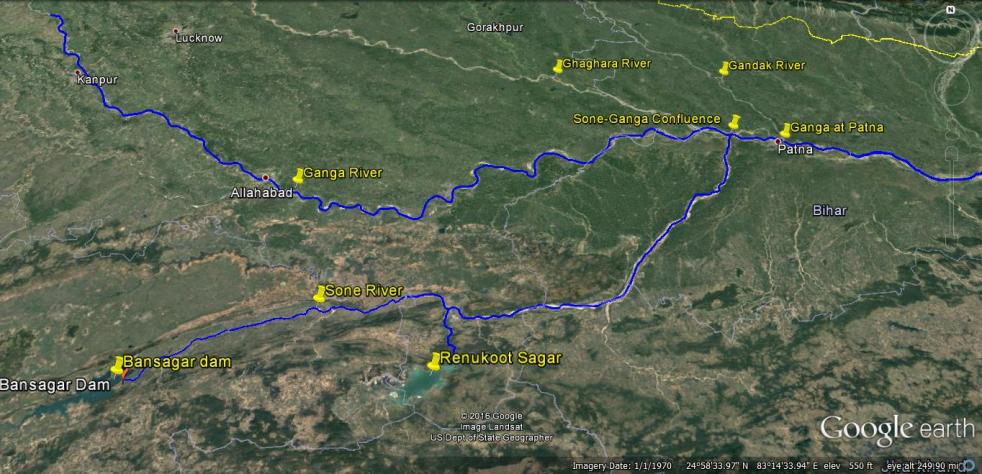
Above: Map Showing the location of Bansagar Dam, Sone River, Ganga River and Patna
Water level of Ganga at Patna reached 50.43 m on Aug 21, 2016 morning with still showing rising trend. This level was already 16 cm higher than the highest ever recorded flood level (HFL) of Ganga at Patna of 50.27 m. By Aug 22, 2016, at three more sites along Ganga, the water level had already breached the highest recorded levels: Balia in Uttar Pradesh (Ganga Water level at 60.3 m, higher than the HFL of 60.25 m recorded on Sept 14, 2003), Hathidah in Bihar (Ganga water level at 43.17 m, higher than the HFL of 43.15 m recorded on Aug 7, 1971, that is 45 years back) and Bhagalpur in Bihar (Ganga water level at 34.55 m, higher than HFL of 34.5 m recorded on Sept 3, 2013). This means that the highest flood level that started at Patna is now travelling both upstream and downstream along Ganga.
Several districts of Bihar along Ganga are facing floods, with at least 10 lakh people affected and about 2 lakh people displaced. On Aug 21 alone, NDRF teams have rescued over 5300 people from Didarganj, Bakhtiyarpur, Danapur Chhapra, Vaishali and Maner. At least ten lakh people have been affected in Bihar, two lakh have been displaced and scores have been killed. It seems more like and annual natural calamity.
But that is not the case, if we look closely. Available information shows that the unprecedented floods that we are now seeing in Ganga in Bihar and UP are largely due to contribution of two dams: Bansagar Dam along Sone river in Madhya Pradesh in the upstream and Farakka Dam (misleadingly called a Barrage) on the Ganga river in West Bengal. If Bansagar Dam was operated in optimum way, than it need not have released over ten lakh cusecs of water. As pointed out by Bihar government, the high floods brought by Ganga in Patna are majorly due to the high flow contributed by Sone river upstream of Patna. Continue reading “A tale of two dams: Is Bihar’s unprecedented flood an avoidable man-made disaster?” →