Environment Impact Assessment · Ganga

Kanhar Project in UP: Another unwanted dam

Guest Blog by: Debadityo Sinha (debadityo@gmail.com)

  • We do not want dams; in fact we don’t need it. It is the industries for which they need water, and for which they want us to give up our fertile ancestral land and destroy the forests which we have protected since centuries and put our children in danger.”

An affected villager

Kanhar Dam is one of those projects which is an example of how so called developments worsen the situation for the people and environment. The project conceived 37 years ago has been in abeyance since last 25 years. With the latest inauguration of construction of the dam on 5th December, 2014 after a span of 25 years without a fresh proper cost benefit analysis (CBA), any environment impact assessment (EIA) or Social Impact Assessment (SIA) ever, the commencement of project activities is making way for a large social uprising in the heavily industrialized zone of Uttar Pradesh.

Google Earth Image showing the proposed dam site

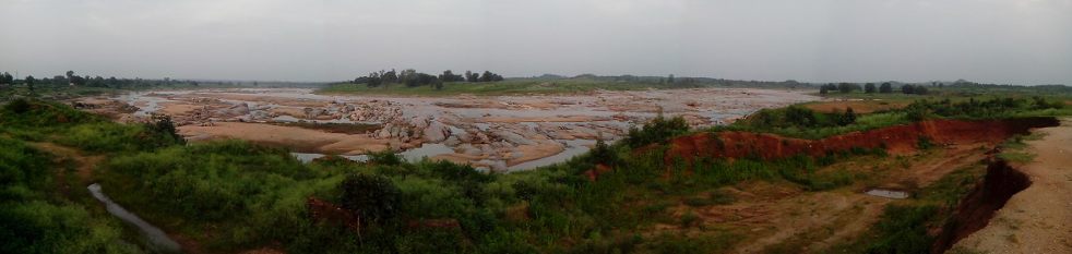
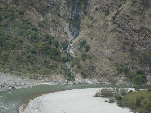
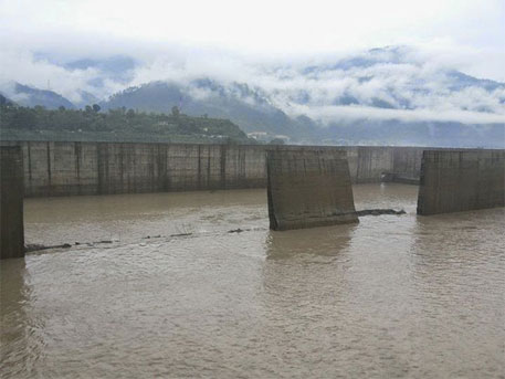
Kanhar Irrigation Project is located downstream of the confluence of River Pagan with Kanhar near village Sugawan in Tehsil Dudhi of District Sonebhadra, Uttar Pradesh. It was originally approved by the Central Water Commission in September, 1976 at an initial budget of Rs. 27.75 Crores. Initially, there was some foundation work undertaken but the project was soon stalled due to inter-state issues, lack of funds and volcanic protests from tribal communities of the region. As per a progress report of the project for 1998-99, the construction work is completely abandoned since 1989-90. Since then, there are numerous occasions when the project was inaugurated, notable among them is one on 15th January, 2011 when the then Chief Minister Mayawati laid foundation stone again. Another inauguration took place when on 12th November, 2012 when Mr. Shiv Pal Singh Yadav (uncle of present CM Akhilesh Yadav), the Irrigation Minister of Uttar Pradesh laid another foundation stone to start the work of spillway. However no work could be taken up.

The project proposes a 3.003 km long earthen dam having a maximum height of 39.90 m from deepest bed level which may be increased to 52.90 m if linked to Rihand reservoir. The project envisages submergence of 4131.5 Ha of land which includes parts of Uttar Pradesh, Chhattisgarh and Jharkhand mostly dominated by tribal communities. The project is expected to provide irrigation to Dudhi and Robertsganj Tehsils via left and right canals emerging from both sides of the dam with capacity of 192 and 479 cusec respectively. The culturable command area of the project is 47,302 ha. The project imposes enormous threat not only on the environment and ecology but also to thousands of tribal families of Vindhyas living there since hundreds of years and has demanded for protection of their forests and proper implementation of R & R (Rehabilitation and Resettlements).

Kanhar Project Map As per 1976 documents

The controversy actually began when the Central Water Commission in its 106th meeting of Advisory Committee for the ‘techno-viability of irrigation, flood control and multipurpose project proposals’ approved the project at an estimated cost of Rs. 652.59 crores at 2008-09 price level. A bare perusal of the minutes shows that there is no consideration of the environment and social impacts of the project. The minutes also show that the approval was granted in the presence of representatives of Ministry of Environment and Forests and Ministry of Tribal Affairs.

Local Voices Suppressed

The inauguration of the project held on 5th December 2014 was marked by the presence of heavy police force and paramilitary forces which were deployed to guard the construction site on the river bed. Few roads have been blocked by Police and it is reported that the entry to the project site is stopped 1.5 km ahead of the construction site. To speed up the work, regular increase of heavy equipments and machinery is in progress.  CCTV cameras are also reported to be installed at the site to keep a regular check on the activities.

Forests Devmanwa Pahadi in village Bhisur

There is a constant effort by the administrative authorities to suppress the voices of aggrieved and affected raised against the project  and those who have attempted to do so are being arrested under the Uttar Pradesh Gunda Niyantran Adhiniyam, 1970 or ‘Gunda Act’. There are repeated incidences of arrests and FIRs against the local people. Incidences of people-police clashes are now becoming a daily routine affairs. Recently the SDM, Dudhi along with the other policemen was also injured in a similar clash. In retaliation to it, there were series of arrests being made by the police and FIRs were filed against 500 unnamed locals. There is an atmosphere of fear already created among the villagers in the region.

The question arises is, whether due procedure has been adopted by the state government as prescribed under law? And if yes then what is the reason for suppressing the voices and why is so such chaos being generated by the government? The project is in controversy due to several questions which are still left unanswered and requires a detailed clarification from the State Government.

The rise of Kanhar Bachao Andolan

The Kanhar Bachao Andolan (KBA) is the first of its kind integrated protest which emerged in the form of an organization in the year 2002 under leadership of a Gandhian activist Bhai Maheshanandji of Gram Sawaraj Samiti based in Dudhi tehsil of Sonebhadra and Gram Pradhans of villages which would be submerged if the project is implemented. The KBA has been raising the issue of tribal rights and discrepancies in the R & R before the state govt. through representations, protests and petitions in High Court. There is a continuous peaceful campaign against the project by KBA since a decade including the unceasing protest which started from 5th December, 2014 on the other side of the River Kanhar opposite to the construction site. Fanishwar Jaiswal, who is a former-Gram Pradhan of Bhisur village and an active member of KBA said, “There was a public meeting organized by the MLA of Dudhi in June, 2014 to address the R & R issues. The Gram Pradhans of several villages presented their views against this project and also submitted written representations; however those views and protests were never registered by the government in any of their reports.”

Protests on Kanhar RIver Bank at Sugawaman village

Rich Forests and Tribal Culture at Stake

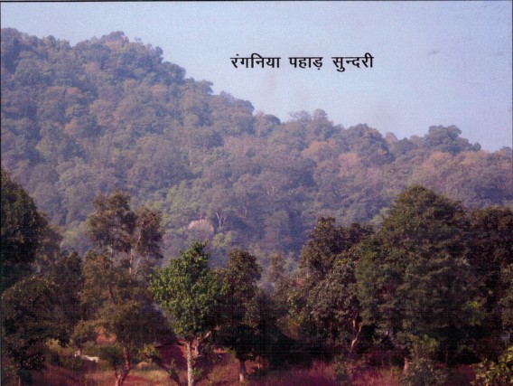
I got a chance to visit Sonebhadra district in July, 2014 where I came to know about this project and the ongoing protests. I visited the project area and interacted with the people of Sundari and Bhisur villages of Dudhi tehsil which are the affected villages among several others. Dense forests and agricultural fields were the most common landscape feature.  One could have seen the abandoned machines, several of which were half-sunk to the soil, broken houses with ghostly appearances which were informed as the once constructed officer’s colonies of the project and old rusted sign boards stating ‘Kanhar Sinchai Pariyojna’. Those structure and abandoned equipments were clear evidences of the Kanhar project which was abandoned long back by the government.

Till 1984, a large number of trees were felled by the government in the midst of protests by the tribal communities. But, since then the work did not take place and there was no displacement of tribals. They have now planted more forests in their villages and have their own regulation bodies for protection of these Forests. “Cutting trees is seen as sin in our culture and we have strict fines and punishments if someone does that. Trees are our life and we are protecting them for our children”, said Pradhan of village Sundari which will be the first village to be submerged by the project.

Sundari Forests to be affected due to Kanhar Dam in Uttar Pradesh

We discussed about the status of biodiversity and came to know about their dependence on traditional medicines which they obtain directly from the forests. All the villagers I met were satisfied with their rural lifestyle and have developed their own way of sustaining agricultural production by choice of specific vegetable, pulses and crops depending on climate.

It was informed that every year elephants visit the Kanhar River from the Chhattisgarh side. Animals like Sloth Bear, Leopard, Blackbuck, Chinkara and several reptiles are abundantly noticed by people due to presence of hills and forests in the region.

‘We do not want dams; in fact we don’t need it. It is for the industries which need water, and for which they want us to give up our fertile ancestral land and destroy the forests which we have protected since centuries’, said a villager.

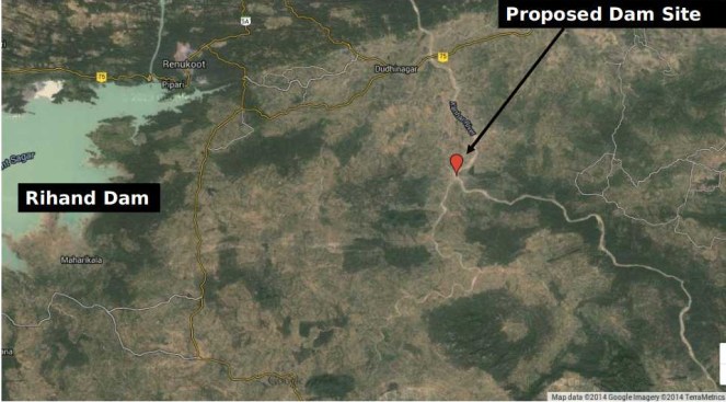
It is suspected that the Kanhar dam is being constructed to supplement the Rihand dam to provide water for the industries in Sonebhadra and adjoining region. It seems that the government has not learnt from the experience of Rihand dam which was constructed in 1960s in the same district in the name of irrigation, but gradually diverted the water for thermal power plants and industries. The water in Rihand dam is now severely contaminated with heavy metals which has entered the food chain through agriculture and fish.  Like the Rihand dam, the new project will cause more destruction than good to the people of the region.

Vindhya Bachao’s Intervention

It is very clear that the project is going to destroy a huge area of dense forests and going to displace not only the tribal communities from their roots but also affect the rich flora and fauna of the Sonebhadra. To know about the actual status of the environment and forests clearance of the project, RTI (Right to Information) applications were filed with the Ministry of Environment, Forests and Climate Change in July, 2014. The belated reply was received only in Dec, 2014 on initiating a first appeal.  The responses states that the ‘Environment Clearance’ was granted on 14.04.1980 which is more than 30 years old and therefore any further information with respect to the same cannot be granted since the same is exempted under the RTI Act 2005. Hence, two things are clear that the project requires a fresh ‘Environment Clearance’ under the EIA Notification, 2006 & a forests clearance prior to start of any construction activity.

Police at Kanhar Dam protests

In view of this fact, On 22nd December, 2014 an application was filed by Advocate Parul Gupta on behalf of applicants Debadityo Sinha (Vindhya Bachao) and O.D. Singh (People’s Union for Civil Liberties) before the National Green Tribunal praying for taking action against the UP Government for carrying out construction activity of the project without statutory clearances under EIA Notification, 2006 and Forest (Conservation) Act, 1980. The application came up before the bench of Justice Swatanter Kumar on 24th December 2014 wherein stay orders were issued against the Government with clear indication that no construction activity shall be allowed to be undertaken if they do not have ‘Environment’ ‘ and ‘Forest’ Clearance’ as prescribed under law.

The major Environmental and Social issues which require to be carefully considered before the project is allowed to move ahead are as follows:

  1. Large Social Implications: Nearly 10,000 tribal families are going to be affected directly who will lose their ancestral land permanently. Gram Sabhas of the project affected villages has already passed a consensus against the project and submitted the same to the State Govt.
  1. Dense Forests will be lost: The Renukoot Forest Division is one of the dense forests of Sonebhadra with tree density of 652 per hectare as per data obtained from a forest clearance application involving the same forest division. The Kanhar project document shows 4439.294 Ha of land categorized as ‘Forest and others’. In such case, lakhs of trees will be affected by this project which would cause significant impact on environment, wildlife and livelihood of tribals.
  1. Loss of Rich Biodiversity: Vindhyan mountain range is known for the wildlife and rich diversity of medicinal plants which are inherently linked with tribal culture. Scientific Publications shows there are at least 105 species of medicinal plants in the region which are extensively used as traditional treatment by tribal people. The project will endanger the remaining few patches of forests which are not only the last few remaining patches of rich biodiversity but refuge to several wild animals in this heavily disturbed landscape. Conversations with the villagers will reveal presence of mammals like Sloth Bear, Leopard, Blackbuck, Chinkara, Jackal etc and several reptiles including Bengal monitor and snake species in these forests. The submergence area falling in Chhattisgarh is reported to be an elephant corridor.
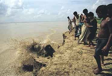
  1. Immense loss to ecology of river Sone and Ganga: Kanhar is a major tributary of River Sone which forms an important catchment of Ganga River Basin. After construction of Rihand Dam and Bansagar dam and various other water abstraction structures owing to number of industries in the region because of availability of coal mines-River Sone is one of the most exploited system which has lost its riverine characteristics. Central Inland Fisheries Research Institute reported disappearance of 20 fish species from Sone in the time span between 1976 and 2011 which is attributed to increased abstraction of water from the Sone river system. The report clearly states that ‘damming of rivers or tributaries is the root cause of river obstructions causing severe modifications and perturbations to the river flow, velocity, depth, substratum, pools, ecology and fish habitat’. There is reporting of 14 exotic alien species in the river. The report claims that the river Sone is in critically modified (class F) condition with discharge of mere 5.16% of Mean Annual Runoff (MAR) and it will require at least 34.2% of MAR to bring it to slightly modified class (class B). In such a scenario, damming of 5200 km2 of the total catchment of 5,654 km2 of river Kanhar will be disastrous for the river Sone depriving it of the major share of the present water availability. As Sone river system forms an important catchment of River Ganga, the impact on ecology of River Ganga is undeniable.
  1. Contribution to Climate Change: We will lose lakhs of trees which would act as carbon-absorption system. To double the problem, the carbon which is locked in the forests will be released to atmosphere when these trees will be felled. While Carbon Dioxide is released from aerobic decomposition of plants, the anaerobic decomposition of organic matters will release methane which is 24 times more potential GHG than Carbon Dioxide. There is global evidence which support production of GHGs in dams, the quantity of which varies on several parameters like climatic conditions, water depth, water fluctuation, area of submergence, dissolved oxygen etc. Emission of GHGs like Methane is known for a positive feedback trigger which would lead to more absorption of heat causing further rise in temperature, thus increasing the rate of anaerobic decay in the reservoirs and release of more Methane.
  1. Lack of Proper Cost-Benefit Analysis: The cost benefit ratio of such projects are calculated on investment and direct benefits from the projects with consideration of impact of project on people & ecosystem, which are often underestimated and excluding socio-cultural costs and cost of a healthy environment and cost of services provided by the river, forest and other ecosystems. The monetary value of the impacts such as on forests, biodiversity, fishing, non-use values, public money spent on infrastructures, cultural loss and other negative impacts are not considered at all.
  1. Lack of Options assessment There has been no options assessment as to establish that this proposed dam is the best option for water resources development in the Kanhar/ Sone basin.

Conclusion

There is no justification for the project. There has not even been an application of mind if the project is beneficial to the people and society. There is not even any impact assessment, nor any democratic decision making process. A huge amount of public money is already spent on development of schools, roads, hospitals, houses etc in the area, which will be lost permanently by this project. At the time, when this project was incepted in 1976 the environment and social scenario of the country and this region was very different from what it is today.  River Sone was not in critically modified state, Forests of Sonebhadra and adjoining regions were still intact, human population was lesser, technology was not so advanced, science of climate change was not fully understood and the need of protection of environment was not felt or required as it is today.  In 1976, protection of rivers was not a primary concern as the problems were not evident as it is today. In such scenario furthering such abandoned projects shows poor understanding of environment and insensitive attitude by the policy makers. It is thus important to undertake a proper cost-benefit analysis, a fresh Environment Impact Assessment and Social Impact Assessment, conduct proper options assessment to understand the implications of this project on the ecological balance and people keeping into account the present scenario. Such studies should undergo a detailed scrutiny and public consultation process.

Panoramic photograph of project site Photo by author

POST SCRIPT UPDATE on March 16 2015 from the author:

Update from NGT hearing dated 12th March, 2015

The Ministry of Environment, Forests and Climate Change has filed its reply before the National Green Tribunal confirming that there exists a confusion with respect to grant of forest clearance diverting 2500 acres of forest land for construction of the Kanhar dam. The Ministry has defended itself claiming that the Forest Clearance dates back to the time when the Ministry was not in existence and therefore the files pertaining to the same cannot be traced. However, it has shifted the burden of proof on the State of U.P. indicating that a letter dated 28.8.1980 by the then ministry of agriculture implies the grant of fc and must be produced by the state.

The state in defence has filed a bunch of letters which according to them refers to the grant of forest clearance. However, the state has failed to produce thee letter dated 28.8.1980 which is claimed to be the FC granted to the project.

The court observed that :

Learned counsel appearing for MoEF submits that the original letter of 1980 granting Forest Clearance to the Project Proponent is not available in the records of the MoEF. Similar stand is taken by the Project Proponent. However, both of them submit that the preceding and subsequent transactions establish that clearance was granted.
…..
Since it is a matter of fact and has to be determined on the basis of record and evidence produced by the parties, we grant liberty to the Applicant to file Replies to this Affidavit, if any, within three days from today.
We also make it clear that one of the contentions raised before the Tribunal is whether it is an ongoing project for number of years or it’s a project which still has to take off and which law will be subsequently applicable today. Let the Learned counsel appearing for the parties also address to the Tribunal on this issue on the next date of hearing. 

Ms. Parul Gupta appeared for the applicants while Mr. Pinaki Mishra and Mr. Vivek Chhib appeared as counsel for State of U.P. and MOEFCC respectively. The matter is now listed for two days- 24th March, 2015 and 25th March, 2015 for arguments. For the order click here   , for Press Release click here

POST SCRIPT ON April 14, 2015:

Urgent Alert

Firing in Sonbhadra, UP

Police firing in Kanhar anti dam proterstors early morning today

against illegal land acquisition by UP Govt

Firing done on the day of Ambedkar Jyanti

Police firing on anti land acquisition protesters at Kanhar dam early morning today. One tribal leader Akku kharwar from Sundari village have been hit by bullet in chest, Around 8 people have been grievously injured in the firing and lathi charge by the police. Thousands of men and women are assembled at the site to intensify the protest against on Ambedkar jyanti. The protesters were carrying the photo of Baba Saheb to mark the day as ” Save the Constitution Day”. Akhilesh Govt fired arbitrarily on the protesters among whom women are in the forefront. Most of the women have injured. The firing is being done by the Inspector of Amwar police station Duddhi Tehsil, Sonbhdara, UP.

Condemn this criminal Act and join in the struggle of the people who are fighting against the illegal land acquistion and constructing illegal Dam on kanhar river.

Roma
Dy Gen Sec
All India Union of Forest Working People

POST SCRIPT on April 20, 2015: Update from Roma: 

Kanhar Dam – Legitimate demands of dalit farmers in UP being crushed ruthlessly, Chhattisgarh adivasi peasants being kept in the dark – says a fact finding team of
Chhattisgarh Bachao Andolan

A fact finding team of the Chhattisgarh Bachao Andolan consisting of Alok Shukla, Sudha Bharadwaj, Jangsay Poya, Degree Prasad Chouhan and Bijay Gupta visited the dam affected villages of the Kanhar Dam in UP and Chhattisgarh on 19th April 2015.
The team first visited Village Bheesur which is closest to the dam site and interacted with the affected families who are mostly of the Dalit community who were still deeply affected by the repression of the 14th April and 18th April.
The affected men and women were very articulate about their grievances and extremely legitimate demands. They explained that they were first told about the Kanhar Dam in the year 1976 when the then Chief Minister ND Tiwari promised 5 acres of land, one job in each family and a house measuring 40’x60’, apart from full facilities of education, health, electricity and water to the 11 affected villages of Uttar Pradesh namely Sundari, Korchi, Nachantad, Bheesur, Sugwaman, Kasivakhar, Khudri, Bairkhad, Lambi, Kohda and Amwaar. In 1983 it is correct that compensation payments were made at the rate of Rs. 1800 per bigha (approximately Rs. 2700 per acre) to the then heads of households. After this the villagers have got no notice whatsoever.
On 07-11-2012 the Irrigation Minister laid the foundation stone of the dam. It was claimed that now a consolidated sum of Rs7,11,000 would be given to the heads of households as identified in 1983 and houses of 45’x10’ dimensions would be constructed for them. The farmers are rightly arguing that they have been in physical possession of the lands all these years and therefore they should be compensated as per the 2013 Act. The government must be sensitive to the fact that the earlier households have multiplied and the compensation must be provided to all adult families who will lose their livelihood. It is also very pertinent that in the meanwhile the Forest Rights Act, 2006 has come into existence and we found that many of the farmers have been granted Pattas under the Act; however the government is refusing to compensate them for the loss of such lands, which is absolutely against the spirit of the Act.
The work of the dam was started on 04.12.2014 and from 23.12.2014 the villagers were sitting in continuous dharna. On that very day, efforts were made to intimidate them. While the SDM and District Magistrate did not intervene till about 6pm, at about 7pm the Provincial Armed Constabulary (PAC) of which about 150 jawans were deployed at the dam site interfered. After the Tehsildar assaulted a young man Atiq Ahmed, people rushed in from the weekly market and a fracas ensued. Right from that day cases were foisted on 16 named and 500 unnamed persons.
Despite this, the villagers continued with their peaceful protest, however since the government was not carrying on any negotiations and at the same time the dam work was progressing, on 14th April they decided to shift the venue of the dharna closer to the site. The PAC opened fire and a bullet passed through Akklu Chero (Cherwa) – an adivasi of Sundari village. 39 persons were injured, 12 of them seriously. The deployment of the PAC was increased to about 500-1000 jawans.
On 18th April early in the morning the administration was determined to remove the protestors. The district force and PAC surrounded the dharna site, uprooted the pandal and mercilessly beat and chased the villagers right up to their villagers. They entered Village Bheesur and not only beat up men and women, but vandalized a motor and motorcycle of Ram Lochan. Colesia showed us her injured arm and fingers and was in tears because she did not know where her husband Mata Prasad was.
People were not certain where missing family members were since the injured have been taken to the Dudhi Health Centre and if any person tries to contact them they face the threat of arrest since between the cases made out against them for the events of 23rd December, 14th April and 18th April cover about 956 persons. But the team found out that the following had been injured mostly with fractures and were possibly hospitalized. The number of women injured is significant:-
Village Bheesur – Rajkalia, Kismatiya Mata Prasad, Uday Kumar and Phoujdar (all ST)
Village Korchi – Phoolmatiya, Butan.
Village Sundari – Ram Bichar, Shanichar, Zahoor, Azimuddin, Jogi.
Village Pathori Chattan – Bhagmani, Ram Prasad, Dharmjeet.
Similarly the PAC people chased the protestors of Village Sundari too right up to the houses on the outskirts of the village. They damaged motorbikes and cycles even setting fire to them.
We observed that the work at the dam site seemed to be progressing fairly fast. The height of the dam which was earlier stated to be about 39.90 m appears to have been increased subsequently to 52.90 m increasing the apprehensions of the people. The Police had cordoned off the area and there were still a large number of PAC trucks and personnel in their makeshift camp of sheets.
When the team reached Village Sundari, there was an extremely tense atmosphere. Some dominant caste-class persons were holding a meeting in which others seemed to be quite subdued. Some very vocal local leaders told us that they do not want any interference from any outside NGO or organization. Most of them were quoting the DM Sanjay Kumar belligerently saying that he had said that all protest and movements should stop. Otherwise he would foist so many cases that they would rot in jail for the rest of their lives and use up all the compensation in paying lawyers. Some persons who seemed to have been sent by the administration were clicking our photos when we introduced ourselves. The leaders told us that they had decided to accept the compensation and would be going to the DM to inform him so as that was the only way the cases would be lifted. While it was clear that not all the persons in the meeting were in agreement with this “decision”, they were clearly cowed down by the cases and the pressure being brought by the administration.
However our most tragic experience was in the affected villages of Chhattisgarh in block Ramchandrapur of district Balrampur. They fall in the “Sanawal” constituency of erstwhile Home Minister Ram Vichar Netam who had assured the villages that there would be no submergence whatsoever in Chhattisgarh. Even when the current MLA Brihaspati Singh of Congress tried to hold a meeting at Sanawal in which he
invited the protestors of UP, lumpen supporters of Ram Vichar Netam made it difficult for him to educate the villagers about this.
We were shocked to find that the Water Resources Department of Chhattisgarh admits that the following 19 villages are to be submerged – Jhara, Kushpher, Semarva, Dhouli, Pachaval, Libra, Kameshwarnagar, Sanawal, Tendua, Dugru, Kundru, Talkeshwarpur, Chuna Pathar, Indravatipur, Barvahi, Sundarpur, Minuvakhar and Trishuli; and 8 to be partially submerged – Chera, Salvahi, Mahadevpur, Kurludih, Tatiather, Peeparpan, Ananpur, and Silaju. Yet the villages are in blissful ignorance.
Only after the incident on the UP side of the dam occurred, on 18th April an Engineer came to Jhara village and stated that 250 acres of land would be submerged out of which 100 acres was private land. But even this is not the truth since it is clear that the entire village is to be submerged. As we were leaving Jhara village we saw a whole convoy of 6 Government Scorpios rushing through the village. Clearly, the state at some point has to begin some legal acquisition proceedings and seem to be at a loss as to how to do so.
Strangely enough, keeping up the pretence of no submergence Shri Netam has had many constructions sanctioned in Sanawal and surrounding villages whereas ordinarily, once there is an intention to acquire, government expenditure is kept to a minimum.
As we returned to Ambikapur, we heard that another fact finding team from Delhi who were to meet with the injured in hospital and the Collector Sonebhadra, had been detained for questioning.
The rapidity and the ruthlessness with which the dam is being built, at any cost, indicates that is unlikely to be for the stated purpose of irrigation. With large industrial projects coming up in Sonebhadra UP and even in neighbouring Chhattisgarh and Jharkhand, on the cusp of which this dam channelizes the waters of Kanhar and Pang rivers, it appears to be that providing water to these projects and also hydel power are likely to be the real causes.
The Chhattisgarh Bachao Andolan comes to the following tentative conclusions on the basis of its fact finding –
1. The demands of the project affected farmers, particularly dalits and adivasis, are eminently reasonable and the administration should enter into sympathetic discussion with them to redress their very legitimate and legal grievances. Work on the dam should be stopped during such negotiations so as to create an atmosphere of good will.
2. The PAC used excessive and unnecessary force on the protestors on both 14th April and 18th April. The complaints of the protestors should be registered as FIRs and action should be taken against the errant police jawans.
3. Using the threat of false cases against the protestors to arm-twist them to accept unjust compensation and rehabilitation is a form of state terror. The cases must be reviewed particularly the practice of filing cases against “unknown” persons, and malicious cases must be withdrawn.
4. In the State of Chhattisgarh, there has been absolutely no transparency, information or following of legal procedure with regard to affected 27 villages. The provisions of the 2013 Act beginning with the pre-acquisition procedure of Social Impact Assessment, Gram Sabha Consultation (all these areas are Scheduled areas), determination of Forest Rights, Public Hearing on Rehabilitation and Resettlement packages etc must be strictly followed.
5. Finally, the attitude of the Uttar Pradesh Government and the district administration of Sonabhadra in restraining activists from entering the area or making an enquiry into the facts on the ground is undemocratic and reprehensible.

Delhi Contact : c/o NTUI, B – 137, Dayanand Colony, Lajpat Nr. Ph IV, NewDelhi – 110024, Ph -9868217276, 9868857723,011-26214538

Lucknow contact : 222, Vidhayak Awas, Aish Bagh Road, Rajinder Nagar, Lucknow, UP
Dehradun Contact : c/o Mahila Manch, E block,Saraswati Vihar, Near Homeguard off, Kargi, Dehrdun, Uttarakhand. ph- 09412348071
POST SCRIPT ON APRIL 26, 2015
From: Sandeep Pandey <ashaashram@yahoo.com>
To:cmup@nic.in” <cmup@nic.in>
Cc: Amod Kumar <amodk2013@gmail.com>; Rigzin Samphel <rigzin123@gmail.com>; Sanjay Kumar <sanjaykumarias02@yahoo.co.in>
Sent: Saturday, April 25, 2015 1:34 AM
Subject: Stop construction of Kanhar Dam
To:                  Shri Akhilesh Yadav
                       CM, UP
 
From:              Ajay Shekhar and Sandeep Pandey
                       Socialist Party (India)
 
Sub: Work on Kanhar dam should stop untill court decisions are pronounced.
 
Dear Akhilesh ji,
                       We want to ask you why your government is trying to forcibly acquire land for Kanhar Dam in Dist. Sonebhadra violating the law of the land whereas your party is opposing the amendments proposed by the Narendra Modi government in the Right to Fair Compensation and Transparency in Land Acquisition, Rehabilitation and Resettlement Act, 2013. In light of the recent incidents of use of force by the District administration on 14th and 18th April, 2015, we wish to say the following.
 
(1) The SC judgement in the case of Niyamgiri hills, empowering the tribals to take a final decision on whether to allow multinational company to undertake bauxite mining there, should be now a precedent in all projects proposed in tribals areas. In addition the 73rd amendment to Constitution empowering Gram Sabhas to take decisions on economic planning for development should be honoured. Case no. 67043/2011 is pending in Allahabad HC relating to this right of GS and we expect that the district administration of Sonebhadra and Government of UP will wait for a decision on this.
 
(2) The project is 37 years old and was abandoned in 1984. The forest clearance dates back to 14/4/1980. It is a joke if the administration claims that it has the necessary environment and forest clearances on the basis of a clearance obtained 35 years back. Why is the Sonebhadra administration and UP government not prepared to wait for the National Green Tribunal judgement on this matter?
 
(3) It is another joke that the district administration wants to proceed on the process of acquisition done around 35 years back whereas the people have not given up their possession till date. The District Magistrate of Sonebhadra claims that he’ll rehabilitate the people displaced due to dam construction in the most ideal manner. But all he has are plans for their housing. What about their livelihood? We believe that land for land is the only proper compensation for a person whose livelihood depends on agriculture.
 
(4) Force should not be used against people who agitate peacefully. Dr. Ram Manohar Lohia severed relationship with his own government in Kerala because there was police firing over people in an incident in 1954. It is people’s democratic right to protest peacefully and government’s must find peaceful resolution to problems.
 
                       We commit to stand by the people in this struggle against the government which is for namesake socialist but is actually serving the interests of capitalists. We condemn all the repressive actions of the government and attempts by the district administration to terrorize people into submission so that they accept the displacement and rehabilitation package.
 
                       We hope that the Government of UP would act in a democratic spirit and respect the rights of people. It should immediately halt the construction work at Kanhar dam site and withdraw all the cases foisted on people so that people in jail may be released.
 
Sincerely,
 
Ajay Shekhar, Vice President, U.P. and Sandeep Pandey, National Vice President, Socialist Party (India) after a visit to the dam site, Sundari and Bhisur villages on 20 April, 2015.

Further reading:

कनहर कथा http://tehelkahindi.com/story-of-kanhar-barrage-project/
– छत्‍तीसगढ़ सीमा पर संगीनों के साए में कनहर बांध का निर्माण
http://naidunia.jagran.com/chhattisgarh/raipur-kanhar-dam-making-start-in-chhattisgarh-border-279906
(Nai Duniya)
– Despite NGT stay, UP govt goes ahead with construction of dam
https://www.hindustantimes.com/india-news/despite-ngt-stay-up-govt-goes-ahead-with-construction-of-dam/article1-1304050.aspx

– “Kanhar dam case: Green panel pulls up environment ministry” By IANS | 22 Feb, 2015

http://economictimes.indiatimes.com/news/environment/developmental-issues/kanhar-dam-case-green-panel-pulls-up-environment-ministry/articleshow/46335741.cms (FEB 23, 2015)

END NOTES:

  1. For NGT order on Kanhar Dam, see: http://vindhyabachao.org/embeds/kanhar/NGT-order-Kanhar.pdf
  2. For a brief video clip on project location, see: http://youtu.be/ZZD_Jk2hDs0
Beas · Himachal Pradesh

Larji Dam Fishladder: an unlovely trinket, a deceptive ornament

Emmanuel Theophilus[1] (etheophilus@gmail.com)

The 126 MW Larji Hydropower project near Aut on the mainstem of the Beas is run by the Himachal Pradesh State Electricity Board (HPSEB)[2]. The dam is constructed a little downstream of the confluence of the two main tributaries upstream, the Sainj and the Tirthan, at the narrowest part of a spectacular gorge, towering with limestone cliffs. The impounded waters of this dam have, since its construction in 2006, drowned the access road to the entire upper Kullu valley including Manali and the hundreds of villages upstream, including access to the entire Lahul valley and the region of Ladakh over the high passes from this end. The HPSEB then constructed a 3 km long tunnel to enable passage of traffic, and many people have warned of the hazardous nature of the tunnel. The 220 odd gods that descend from different valleys, on the backs of people to the lower Kullu valley every year in autumn however, refuse to use this tunnel. This is what compelled the HPSEB to build and maintain this tunnel, and during autumn to winter, to keep the water-storage in the dam low to enable the passage of gods, who have been traveling this route for over three and a half centuries. It is remark-worthy though, that this dam constructed as recently as 2006, seems to be heavily silted-up already and the dark shadows of sediment-shoals are visible just below the waters of the reservoir[3].

Being among the most recently completed, the Larji dam is the only dam on the Beas that has a fish-ladder, so it was of particular interest to us. Seeing no guard at the security booth, we walk in to the HPSEB dam operating office, and ask to speak to an officer about the fish ladder. To our complete surprise, we are spoken to and even taken on a tour of the ladder by a foreman who has worked on the dam for many years.

Having seen an elaborate fish ladder on the Kuri Chhu river in Bhutan of doubtful effectiveness[4], we could not help but look at this one with hope and excitement. Located at around 1,000 meters altitude, this dam was clearly in the way of a host of migratory species of fish. If this ladder design was effective, then surely the ‘barrier’ problem to seasonal migration for breeding and dispersal would have been addressed. Here though, is what we saw and heard.

  1. For one, the flow through the fish-pass seems too small to create an ‘attraction flow’ for fish. But even more obviously, the downstream entrance of the fish ladder is a steep cascade over a couple of meters of broken masonry and rock, that would clearly be un-negotiable by any fish that does not jump that high[5].
Downstream entrance of Larji fish ladder: The 2 m high jump that fish require to enter the ladder can be seen here
Downstream entrance of Larji fish ladder: The 2 m high jump that fish require to enter the ladder can be seen here (all photos by the author)

2. The outlet from the dam reservoir into the fish ladder is blocked off by a metal grill-mesh that is narrow enough to trap flotsam like Bisleri water-bottles. The mesh seemed too fine to let Mahseer of breeding-age pass through, either upstream or downstream.

3. The fish ladder was in a serious state of disrepair. To our questions about whether the ladder worked or not, the foreman says honestly that it does not. We see the reasons for this when we walk down the ̴100 meter length of the fish-pass channel.

Fishladder can be seen in serious state of disrepair and blocked by broken concrete parts can be seen here

4. The Larji fish ladder seemed to be a hash of different designs of fish passes. There were four different design elements in this one fish-pass. It had a slotted-weir fishway design, a low gradient Denil fishway, a steep-pass Denil fishway and a plain concrete culvert on a grade design. Most of these slotted weirs were clogged with fallen rocks and debris from the slope above, and in places, the pools in them were over-flowing the weir in a vertical fall almost 2 meters high.

Steep-pass Denil fishway part of the fishladder can be seen here, water is flowing too rapidly here for any fish to be able to go upstream
Steep-pass Denil fishway part of the fishladder can be seen here, water is flowing too rapidly here for any fish to be able to go upstream. The water picks up momentum down an extremely steep slope with the baffles at 45 degrees to the flow, not offset to slow the water, but concentrating the force of the water in mid-stream flow. The slope seemed to be at almost 40 degrees angle, and the water was turbulent in the extreme in this section. A workable Denilway slope, even for the strongest of swimmers among fish, is not designed to exceed a slope of 20% at most. This was close to a 100% slope

5. The oblique baffles on a Denil fishway are supposed to be placed in a manner that provides staggered partial-obstructions that slow the water down at variable velocities to make it passable for fish. However, here we saw that the water picks up momentum down an extremely steep slope with the baffles at 45 degrees to the flow, not offset to slow the water, but concentrating the force of the water in mid-stream flow. The slope seemed to be at almost 40 degrees angle, and the water was turbulent in the extreme in this section. A workable Denilway slope, even for the strongest of swimmers among fish, is not designed to exceed a slope of 20% at most. This was close to a 100% slope[6].

This part of fish ladder is less steep Denil

The last part of the fishway was a plain concrete culvert on a grade channel, essentially a sloping channel, where even the concrete sides of the channel had toppled over into the river-bed, and the final drop was over a two meter fall into the downstream flow. I asked the foreman whether he knew whether fish managed to make it over this extreme gauntlet. He said that they did not, but that he often saw fish gather and concentrate at the bottom of the dam under the sluice gates, and make futile leaps in an attempt to get over the dam. Clearly, the Larji dam fish ladder is just an unlovely trinket, a deceptive ornament.

Watch a 41 seconds video showing how fast the water is moving through the Larji Dam fishladder at: http://youtu.be/grVaxXPdeyY, Video is by the author.

It seemed to me that the dam builders and operators, the HPSEB in this case, both at the design and the executive levels, were not serious about constructing a fish-pass that would work, and neither were they serious about this at the operation and maintenance aspects. Whether they were serious at all even at the conceptual level, to put in place a mitigation measure that actually helped migratory fish bye-pass the barrier of the dam, or was this part of the design merely to obtain environmental clearance, can only be conjectured about. That hydropower projects can devise deceitful strategies for obtaining environmental clearance is one thing, but what does this tell us about the Union Ministry of Environment and Forests, the Expert Appraisal Committee on River Valley Projects appointed by MoEF, the regional office of the MoEF, the state Fisheries Department and also the state pollution Control Board, who are all variously part of the approval processes for hydropower projects, when they get their environmental clearances based on such ‘mitigation measures’?

Larji Dam - about 100 m long fishladder channel can be seen on the right side
Larji Dam – about 100 m long fishladder channel can be seen on the right side

END NOTES:

[1] This article has been extracted from SANDRP’s publication: Headwater Extinctions: Hydropower projects in the Himalayan reaches of the Ganga and the Beas: A closer look at impacts on fish and river ecosystems, authored by Emmanuel Theophilus, for details, see: https://sandrp.wordpress.com/2014/12/16/new-publication-headwater-extinctions-impact-of-hydropower-projects-on-fish-and-river-ecosystems-in-upper-ganga-and-beas-basins/

[2] The 126 MW Larji project is also infamous for being the costliest hydro-power project per unit electricity generated so far in India. Finally built at a cost of R.s 10.27 billion, which was twice the estimated cost, the Vigilance department unearthed major financial misappropriation by HPSEB officials.

[3] The Larji Dam became infamous in June 2014 when 25 students were washed away downstream from the dam due to sudden and unannounced release of water from the dam, see: https://sandrp.wordpress.com/2014/06/12/nadiya-bairi-bhayi/

[4] https://sandrp.wordpress.com/2014/02/02/fish-ladder-at-kurichhu-hydropower-project-bhutan-some-thoughts/

[5] Other than loaches, those tiny finger sized fish that can even climb (squiggle technique) up high waterfalls, provided there is something like a water-slide at the margins of the fall. They however, are not migratory fish.

[6] CIFRI recommends that the speed of flow of water in a fish-pass should not exceed 2 meters per second. Please see ‘Status of fish migration and fish passes with special reference to India’. MK Das and MA Hassan. CIFRI 2008.

Ganga · Himachal Pradesh · Himalayas · Hydropower · Uttarakhand

New Publication: Headwater Extinctions – Impacts of hydropower projects on fish and river ecosystems in Upper Ganga and Beas basins

SANDRP has just published a new report: “Headwater Extinctions- Hydropower projects in the Himalayan reaches of the Ganga and the Beas: A closer look at impacts on fish and river ecosystems”, authored by Emmanuel Theophilus. The report[i] was released at the India Rivers Week held during Nov 24-27, 2014.

Front Cover of the report HEADWATER EXTINCTIONS

Headwater Extinctions deals with impacts of hydropower projects in Beas basin in Himachal Pradesh and Alaknanda-Bhagirathi basins in Uttarakhand on river ecosystem and its components, mainly fish. While the harrowing impacts of hydropower projects on local livelihoods and social systems are being realized gradually, we are yet unclear about the extent of impacts of these so-called green projects have on fish and aquatic biodiversity.

Environmental Impact Assessments of large hydropower projects (> 25 MW as per EIA Notification 2006[2]) are supposed to assess ecological impacts of such projects, but we are yet to come across any comprehensive effort in this direction from EIA reports that we have assessed so far.

The Expert Appraisal Committee (EAC) of Union Ministry of Environment, Forests and Climate Change (MoEF & CC) which is entrusted with appraising these projects and their EIAs has paid very little attention to this issue. Since over a decade, the EAC has had expert members from Wildlife Institute of India (WII) and Central Inland Fisheries Research Institute (CIFRI). Both these institutes are supposed to have expertise on fish and aquatic biodiversity. But sadly, their presence has not helped fill the serious lacunae in appraisal and EIAs of the hydropower projects.

SANDRP had been trying to highlight the impact of hydropower on fish and the long standing problems in the so-called mitigation measures being recommended by the EAC. We thought that it may be useful to bring out a first-hand report bring out ground realities of what is happening to our rivers. Emmanuel Theophilus, based in the Dhauliganga Valley and who is an avid mountaineer, storyteller, ecologist and our ally was commissioned by SANDRP to study the impacts of hydropower on fish and ecosystems, review the EIAs as well as mitigation measures recommended by EAC as a part of Environment Management Plans of hydropower projects. We are very glad to publish the report as a first of the hopefully many steps to be taken to understand and address this important issue.

Headwater Extinctions has been written in an eminently readable style that Theo is known for, as could be seen from the earlier blogs[3] he wrote for us! The report has a section on ‘Travelogue’ which records Theo’s travels and thoughts as he visits Bhagirathi and Alaknanda sub basins in Uttarakhand and Beas basin in Himachal Pradesh. The report also brings illuminating photos from these trips. The fact that the travels happened within months of the Uttarakhand disaster of June 2013 could be seen in his photos and travel reports. It further substantives the role hydropower projects played in increasing the proportions of the disaster.

Travelogue is followed by discussions in two parts: Discussions on the impact of hydropower projects on fish and aquatic habitats along the two sub-basins and the role of EIAs, EMPs, Fisheries Plan and the government approval process. The findings of this report are valid for all Himalayan states & rivers.

Back Cover of the report HEADWATER EXTINCTIONS

Headwater Extinctions ends with some striking insights. Sample this: We are in the midst of river extinctions in the Himalaya, but are surrounded by a tragic drama of double-speak and equivocation. And a horde of jostling brokers. Ranging from reputed universities, government departments, research institutions, everyday bureaucrats, and of course, politicians and contractors from within ‘the community’[4] along the developers and regulators. They not only write the script of this drama, they even play all the part”.

The inside covers of the report have detailed maps of the two basins with locations of hydropower projects, with annexures containing lists of hydropower projects in Upper Ganga and Beas basins and also list of fish found in Upper Ganga basin.

Theo has completed this report on a stringent timeline and budget, which meant that all the proposed and implemented fisheries management plans could not be assessed. We hope Headwater Extinctions provides sufficient material and compelling reasons to overhaul the way impacts of hydropower projects on fisheries and aquatic biodiversity are treated by EIAs, EMPs and government committees. We would also urge agencies like WII and CIFRI to do justice to their work inside EAC and beyond. That they are not doing that is apparent.

For EAC and MoEF&CC, we certainly would like them to ensure proper and full impact assessment of projects on aquatic biodiversity in the EIAs. The EAC also needs to stop approving completely ineffective fish hatcheries. They could initiate a credible independent study of the costs, benefits and performance of the fisheries development plans they have been approving in recent projects. It does not only smell fishy, but more like a scam! Here is a relevant quote from the report: “I can’t help see a few things here, as perhaps you do? Bluntly put, I see slush funds being dangled to a whole range of possible collaborators. The kindest term I can find for them is ‘brokers’.”

We look forward to your comments and suggestions on all aspects of Headwater Extinctions. If you would like a hard copy, please write to us.

SANDRP (ht.sandrp@gmail.com)

END NOTES:

[1] The full report is available on our web site, at: https://sandrp.in/Headwater_extinctions221114.pdf

[2] We have been saying this for long and this report helps substantiate our contention that the assumption that projects below 25 MW are benign and do not need EIA-EMP or environmental monitoring and public consultations is wrong.

[3] https://sandrp.wordpress.com/2014/02/02/fish-ladder-at-kurichhu-hydropower-project-bhutan-some-thoughts/ and https://sandrp.wordpress.com/2013/09/27/uttarakhand-floods-of-june-2013-curtain-raiser-on-the-events-at-nhpcs-280-mw-dhauliganga-hep/.

[4] Caveat, there are honest exceptions, but this is a generalization that describes the predominant phenomenon.

Ganga

Lessons from Farakka as we plan more barrages on Ganga

Introduction

“When Farakka barrage was built, the engineers did not plan for such massive silt. But it has become one of the biggest problems of the barrage now” said Dr. P.K. Parua[1]. And he should know as he has been associated with the barrage for nearly 38 years and retired as the General Manager of Farakka Barrage Project (FBP). I remembered the vast island of silt in the middle of the river barely a kilometer upstream of the Barrage and the people who told us their homes were devastated by the swinging river.

Silt Islands just upstream the Barrage. Photo: Parineeta Dandekar, SANDRP

Though called a barrage, Farakka Barrage is a large dam as per ICOLD, WCD and CWC definitions, with associated large dimensions and impacts. To call it a Barrage is misleading.

Commissioned in 1975[i] across Ganga in Murshidabad District of West Bengal and just 16 kms upstream of the Bangladesh Border, Farakka Barrage has been mired in controversies from the very beginning. Its role is singular: to transfer 40,000 cusecs water from Ganga to its distributary Bhagirathi-Hooghly (hence forth referred as Hooghly). And to make Hoogly river navigable from Kolkata port upstream till Farakka barrage. It was thought that this water will push the silt that is eating up the Kolkata Port and will protect the Port for navigation and economy. In reality, Kolkata Port continues to decay and the barrage has had such severe and unforeseen impacts on the people of India and Bangladesh that the call to review Farakka Barrage entirely is getting louder by the day.

A lot has been written about Farakka Barrage by Indian (and many times by Bangladeshi) authors, so why are we discussing Farakka again? Because Political leaders like Shri. Nitin Gadkari have stated that there are plans of building a barrage after every 100 kms in Ganga from Haldia to Allahabad, a 1600 kms stretch. So we are looking at possibly 15 more barrages on Ganga. But before taking decision about building any other such structure, we need to understand the range of impacts a single barrage has had on the lives of millions of people and how inadequate has been our response in addressing these impacts. Farakka holds critical lessons for Indian politicians, policy-makers, international groups and financial institutions like World Bank dreaming of making a string of barrages across a river which has one of the highest silt loads, densest population and the largest deltas in the world.

Ganga as a “Waterway” Government of India is planning to aggressively develop 1620 kilometers of National River Ganga as “National Waterway 1” (NW1). There is a profound difference between a Highway and Waterway. A highway is simply a road while NW1 is actually River Ganga, performing several other functions, it is important to recognise how the NW1 would affect these functions and the river itself. NW 1 spans from Haldia, near the mouth of Ganga Estuary in West Bengal, to Allahabad in Uttar Pradesh, passing through four states and cities of Haldia, Howrah, Kolkata, Bhagalpur, Buxar, Patna, Ghazipur, Varanasi and Allahabad.

The Inland Waterways Authority of India (IWAI)[ii] plans to use this waterway for the transport of “coal, fly-ash, food grains, cement, stone chips, oil and over dimensional cargo.” Not surprisingly, companies keenly interested in using this waterway include “thermal power plants, cement companies, fertilizer companies, oil companies” etc.  In order to make this stretch navigable, IWAI plans initiatives like “river training and conservancy, structural improvement, dredging, and Construction of terminals at Allahabad, Varansai, Gazipur in Uttar Pradesh, Sahibganj in Bihar and Katwa in West Bengal.”

Although this plan was on paper for some years, the new government has approached the World Bank for support of nearly Rs 4200 Crores (700 million dollar) for its implementation. In July 2014, the World Bank agreed to fund initial 50 million dollars including technical support (thus creating work for its own experts!). World Bank Team has already visited Patna for this project and joint meeting of IWAI and World Bank has taken place at Varanasi[iii]. No public consultation has been held thus far.

Although River Navigation has nothing to do with River Rejuvenation, Shri. Nitin Gadkari, Union Surface Transport & Shipping Minister with additional portfolio of Rural Development, who played an active role in the Ganga Manthan, announced this navigation plan as a part of ‘Ganga Rejuvenation’.[iv]

He also announced that the plan entails erecting barrages (dams) on the Ganga at every 100 kilometer interval from Haldia to Allahabad. This would mean damming the Ganga rough about 15-16 times, to maintain water levels and navigability.[v]

If the plan moves ahead, it may escape environmental clearance as the very limited EIA Notification 2006, being actively amended for dilution by the Modi government, includes only irrigation and hydropower dams in its ambit. This does not mean that these barrages will not have severe impacts on the river, its people and its ecosystems. Far from it. SANDRP has written about the impacts of Upper Ganga Barrage at Bhimgouda, the Lower Ganga Barrage at Narora and the Farakka Barrage in Murshidabad, West Bengal (SANDRP’s Report on Farakka, 1999: https://sandrp.in/dams/impct_frka_wcd.pdf).

The analysis at hand is based on official documents and research, site visit, interviews and discussions with experts and local people.

  • Farakka Barrage, in the backdrop of proposed Barrages

Farakka Barrage, 2.62 kms long, commissioned in 1975 has a unique purpose. The barrage was built for diverting waters of Ganga into its distributary The Hooghly/ Bhagirtahi, for flushing sediments and maintaining the navigability of Kolkata Port (& Hooghly River) which lies at the mouth of Hooghly. Records about high sedimentation in Hooghly can be traced back to 17th Century, but is known to increase following building of Damodar Dams in post independent India. Construction of a barrage on Ganga and diverting its waters into Hooghly was suggested in the 19th Century by Sir Arthur Cotton. After independence, the historic Kolkata port was becoming hugely silted due to sluggish freshwater from upstream on the one hand and and strong saline intrusion from the sea on the other. At that time, Farakka Barrage was thought to be an answer to these problems.

Farakka Barrage
The Farakka Barrage. Photo: Author

Even then, some lone voices highlighted the possible impacts of Farakka Barrage. Notably Mr. Kapil Bhattacharya, Engineer-in-Chief of West Bengal had warned about absence of sufficient water, catastrophic floods and sedimentation in the upstream back in 70s.  When Pakistan (current Bangladesh was part of Pakistan during 1947-1971) upheld his views, he was branded as a traitor and lost his job. He had highlighted that one of the main reasons why Hooghly was desiccating was Damodar Valley Corporation (DVC) dams on Damodar and Roopnarayan Rivers.

The Farakka Barrage completed in 1975 has 109 gates, and a feeder canal of 38.1 kms emanating from the right bank, carrying water from Ganga to Hooghly. There is one more barrage at Jangipur in the downstream and afflux bunds in the upstream of Farakka, diverting waters of all smaller rivers like Pagla and Choto Bhagirathi into Farakka, effectively drying them in the downstream.

The Feeder canal is supposed to divert 40,000 cusecs water continuously from Ganga into Bhagirathi/ Hooghly. Hooghly-Bhagirathi itself is not a small river. It is a system drained by 7 tributaries like Pagla, Bansloi, Mayurakshi, Ajoy, Damodar, Rupnarayan, Haldi and the two offshoots of Ganga – Jalangi and Churni.

Location of Farakka Barrage  Depiction From : Rudra,
Location of Farakka Barrage Depiction From : Rudra, Encroaching Ganga and Social Conflicts
  • Impacts and performance of Farakka Barrage

Several grave questions are being posed on the utility of the barrage itself and its impacts. Some of the main points are illustrated below:

  1. Hooghly estuary cannot be made silt-free by 40,000 cusecs from Farakka only

River Expert Dr. Kalyan Rudra, an authority on rivers in Bengal, especially their interactions with sediment, says that the initial objective of Farakka of flushing silt from the mouth of Hooghly has been “frustrated”[vi]. This assessment has been supported by many, including the past Superintending Engineer of Farakka Dr. P.K. Parua (Pers. Comm.) According to Kolkata Port Trust, the dredging of silt at Kolkata Port has been rising from 6.40 million cubic meters (MCM) annually from Pre-Farakka days to four time increase at 21.88 MCM annually during 1999-2003.

The answer, according to Dr. Rudra, lies in the fact that freshwater flow brought by the Hooghly Estuary, even with 40,000 cusecs from Farakka is just too meagre to flush sediments deep down the estuary. The difference between volumes of freshwater brought by Hooghly, as against the tide bringing saline water from south to north is as much as 1:78,  making any deep flushing due to freshwater nearly impossible. Dams in the Hooghly Bhagirathi Basin by Damodar Valley Corporation have further arrested freshwater which could have naturally replenished Hooghly estuary. At the same time the stated aims of Damodar Valley Corporation, fashioned on the lines of Tennessee Valley Authority have not been fulfilled.

Currently, the functioning of Kolkata Port and Haldia port is entirely at the mercy of Dredging Corporation of India (DCI) to desilt the river to maintain sufficient draft (allowable depth of a ship’s keel under water). DCI gets about Rs 300-350 Crores per year for dredging the channel, although several problems have been unearthed like dumping the excavated silt back in the estuary from where it is washed back in the channel. In 2009, the Government of India had actually written to the Kolkata Port Trust, saying that it has become a “liability” and it should explain why it should continue to receive dredging subsidies. A PIL has been filed[vii] in 2013 in Kolkata High Court to save Kolkata and Haldia ports by intensive dredging.

Dredging the National Waterway I Photo: WRIS

It is clear that 40,000 cusecs water from Farakka is not able to help the Kolkata Port much as was envisaged earlier. SANDRP tried to talk with officials at the Kolkata Port Trust, but they declined answering any questions saying that Farakka is a bilateral issue.

This has led to a situation where we have the barrage and the impacts of two countries and millions of people, without even achieving objective for which the project was developed.

2. Sedimentation in the upstream of Farakka Barrage and its massive implications for India and Bangladesh

It is estimated that Ganga carries a silt load of 736 Million Tonnes (MT) annually, out of which about 328 MT of sediment gets deposited in the upstream of Farakka Barrage ANNUALLY[viii]. This annual addition of enormous sediment in the upstream of the barrage has made the river extremely shallow and any ship transport past Farakka has become nearly impossible. As we saw during our visit, islands/chars have formed barely a kilometer upstream the barrage, where animals graze, making any transport nearly impossible.

This massive retention of sediments has resulted in a two-pronged problem:

3. Contribution to delta subsidence and rising sea level in Bangladesh and India

Water released below Farakka barrage has significantly less silt load as about 328 MT silt gets deposited at Farakka. This water has a higher eroding capacity and erodes downstream riverbed. But there is an additional problem: World Heritage site of Sunderbans at the mouth of the Ganga-Brahmaputra-Meghna delta, shared between India and Bangladesh is witnessing possibly the first and highest numbers of Climate Change refugees in the world due to Ingressing Sea which is eating away at smaller islands and the delta. Part reason for this delta subsidence is sea level rise due to global warming and related changes, but the driving reason for encroaching seas is not only sea level rise, but the sinking river delta due to trapping sediment in the upstream dams and barrages like Farakka. The role of river sediments in building deltas is crucial. Ganga-Brahmaputra-Meghana Delta is subsiding rapidly and is categorized as a ‘Delta in Peril’ by experts like Syvitski et al, due to reduction in sediments reaching the delta and compaction of delta, furthering sea level rise. According to recent studies, the rate of relative sea level rise per year in the Ganga Brahmaputra delta is in the range of 8-18 mm per year, one the highest in the world. The related sediment reduction has been a whopping 30% in the twentieth century. (SANDRPs report on Delta Subsidence and Effective Sea Level Rise due to sediment trapping by dams: https://sandrp.wordpress.com/2014/05/07/sinking-and-shrinking-deltas-major-role-of-dams-in-abetting-delta-subsidence-and-effective-sea-level-rise/)

Farakka Barrage has been highlighted as one of the causes for this blocking of sediments at an important juncture. Any role played by Farakka in delta subsidence of GBM Delta has a massive impact on millions of people residing in this delta. According to Prof. Md. Khallequzamman (Pers Comm.), the amount of sediment influx flowing into Bangladesh from upper reaches in India has dropped from 2 billion tons per year in the 1960s to less than 1 billion tons per year in recent years, which is not enough to keep pace with rising sea.[ix]

4. Erosion in the Upstream of the barrage due to Sedimentation

Farakka Barrage is getting silted up due to millions of tonnes of sediment being deposited in the upstream annually. Ganga has been a meandering river, changing courses over centuries, forming paleo channel and ox bows. This deposition of sediment in the upstream is accelerating swinging of Ganga alarmingly to the left bank of the river. This is leading to tremendous erosion in Malda and surrounding regions. More than 4000 hectares of land in Malda has been eroded by the Ganga since 1970s. The river has also breached 8 embankments. Although a number of authors have conclusively written about this and even Legislative Assembly of West Bengal has been unequivocal in saying that “It is accepted all levels that the construction of Farakka Barrage is solely responsible behind the erosion of river Ganges in Malda district”, Central Water Commission trivializes this fact and does not accept any responsibility of Farakka.The only issue CWC seems to be bothered about is the health of the barrage itself which is compromised by erosion on the left bank. In official correspondences of CWC and MoWR scrutinized by SANDRP, the agencies do not mention anything about plight of thousands of people, who are refugees of a swinging river, but are only concerned about the strength of the barrage.[x]

According to Audit Report on Farakka Barrage by Indian Audit and Accounts Departments, between 2006-2012, the “Unintended Consequences” of Farakka include:

  • Induced water through feeder canal raised water level of Bhagirathi by about  5 meters near Jangipur and does not allow Bansloi and Pagla to join Bhagirtahi freely. A new wetland due to congestion formed Ahiron Beel which has submerged fertile land.
  • The barrage has trapped substantial sediment and hence river in changing course. In homogenous situation the oscillation of river is secular but it gets aggravated due to Farakka Barrage. On account of Rajmahal hills on right bank and Farakka barrage on the channel, the river erodes the left bank.
  • The 10 day cycle of increased and decreased release of water from the Barrage has resulted in a complex phenomenon of recharging  ground water by river and then receiving base flow from groundwater ( when river is low). The frequent change in water level on account of 10 day altered flow adversely affects the rivers hydro geomorphology leading to escalating bank erosion.
  • River bed height in Farakka pondage has increased and the river is compensating this reduction by expanding its cross section sideways
Bank Erosion and Embakment breach at Hiranandpur Phot with thanks: Soumya Desarkar

5. Erosion Downstream of the barrage, leading to loss of life and property:

Sedimentation upstream the barrage, coupled with natural swing of Ganga has meant that the river is swinging to the left, encroaching the left bank, leading to erosion in thousands of villages, roads, fields  in the downstream of the Barrage in India as well as Bangladesh, causing annual floods. The Irrigation Department West Bengal (Report of the Irrigation Dept for 1997-2001) itself has agreed not only about this erosion due to Farakka Barrage, but has also cautioned about the possibility of outflanking of the Farakka Barrage itself.  Many experts maintain the eminent possibility of Ganga outflanking the barrage to flow through its old course of the 15th century, which will reduce the barrage to just a bridge.

On our visit to Farakka, Kedarnath Mandal, a veteran activist working on issued of Ganga and Farakka accompanied us to see extensive erosion in the left bank of the river in the upstream at Simultola as well as downstream in Chauk Bahadurpur. In both these regions, the eroding river has paid little heed to the erosion control measures on the banks. Huge boulders have been swept with the current, destabilizing land in their wake.

AntiErosion_Downstream
Washing away erosion control measures at Chow Bahadurpur downstream FBP Photo: Author

We saw extensive bank erosion in the left bank on the downstream where all measures like bull headed spurs, dip trees, porcupines, gunny bags, geo-synthetic covers, boulders bars, boulder crates with nets, etc. have been eroded.

In all this din, the people residing in the chars, their leaders like Kedarnath Mandal, River experts and even the Legislative Council of West Bengal maintain that though erosion and changing courses is a character of Ganga, it has worsened and accelerated hugely since Farakka Barrage. In fact the 13th Legislative Assembly Committee (2004) in its 7th Report notes “It is accepted at all levels that the construction of Farakka Barrage is solely responsible behind the erosion of river Ganges in Malda district”.

6. Near Impossibility of desilting Farakka Barrage

To say that the challenge of desilting Farakka Barrage is Herculean, will be an understatement. The irreversible circle of events is highlighted by the fact that in order to have any appreciable impact, the amount of sediment lifted from the barrage should be at least twice the amount deposited per year, if the project is to be completed even in thirty years. But that seems impossible. According to Dr. Rudra, “Doing so will require a fourteen lane dedicated highway from Malda to Gangasagar” and the transport cost alone “would be nearly twice the revenue earned by Government of India in a year.” Dr. P.K. Parua also accepts that desilting the barrage will be next to impossible.

Such is the scale of sedimentation at Farakka.

7. Source of conflict with Bangladesh

Experts and authorities from Bangladesh have been raising the issue of impact of Farakka for several years now. Farakka Barrage not only obstructs the flow of sediments in Bangladesh, but also diverts waters of Ganga away from Bangladesh delta, depriving millions of fisherfolk and farmers from their livelihood. Water sharing from Farakka, particularly in lean season is now governed by Ganges Water Treaty of 1996. The Treaty holds force between 1 January to 31st May each year and water sharing calculations are based on 10 day flows. Some experts from Bangladesh have maintained that Ganges Water Treaty is not being implemented properly and Bangladesh is receiving less water than its due.[xi]  There are issues raised by the Indian side as well of dwindling water availability. All in all, the barrage and the resultant Treaty continues to be a source of impacts for the river and people of the two nations.

  • Meeting officials at Farakka Barrage

SANDRP met with the Authorities at the Farakka Barrage Project  office, which is under the Ministry of Water Resources (MoWR), at New Farakka. After meeting the officials, it was clear that they have no program for silt management at all. They do not even see this as an area of concern and are only concerned with anti-erosion works, which are failing miserably, and releasing water to Kolkata Port, which is not improving its navigability.

While some may argue, rather irrelevantly (considering the warnings of Kapil Bhattacharyya), that Engineers in 1950s, 60s and 70s were not equipped or aware of the issues related to sediment and its far-reaching impacts like erosion, deposition, floods, even sea level rise, the same in any case cannot be said about the current water management. They have the privilege of better knowledge, better resources and also lessons from past experiences. But despite having clear evidence that silt of Ganga is playing havoc with millions in India as well as Bangladesh, the Farakka Barrage Authorities tell us that they have no plan for silt management the barrage except annual erosion control measures.

The mandate of the barrage authorities is also 120 kms of bank erosion works, 40kms in the upstream and 80kms in the downstream. We were told on the condition of anonymity that this extensive work leaves little time even for maintaining the barrage. The bank protection work is also not permanent and is eroded with flood waves. The bureaucratic set up at Farakka makes it impossible to take proactive decisions about Barrage maintenance. The gates of the barrage need replacement, but there is hardly any agency interested in working for Farakka Barrage due to bureaucratic delays.

The officials told SANDRP that the only desilting measure that can be adopted is opening all gates of the Barrage, but that will not be possible unless all gates are replaced as many gates are faulty. Replacing all gates of Farakka will take at least two more years and we do not know even after that whether silt can be flushed. Such a flushing will need a major flood event and the impact of such sudden flushing of billions of tonnes of silt in the downstream will be unprecedented & huge.

Meeting with Farakka Barrage Authorities leaves one with more questions than answers.

  • Interview with past official of Farakka

SANDRP discussed the multiple issues of Farakka with one of the senior retired official from the Farakka Barrage Authority who has seen the work of the FBPA closely over several years. Some excerpts from these discussions.

SANDRP: Sir, do you think Farakka is fulfilling its functions?

Answer: Farakka was not only designed for diverting water for Hooghly, it was foreseen that there may be an Irrigation component and even a hydropower component. But the inflow at the barrage was over calculated. We never had that sort of inflow in the project. Add to this Treaty with Bangladesh in 1996 and India was left with little water. I would say objectives of Farakka were only partially fulfilled. The barrage has a designed discharge of 27,00,000 cusecs and we have been able to achieve that discharge only twice since commissioning the barrage. In the recent years, water flow has been declining sharply at the barrage. This further handicaps all its functions.

SANDRP: There are several problems associated with silt deposited in the upstream of the barrage like floods, change in course of the river, erosion, etc. Is there any way to tackle this deposited silt?

Answer: Yes, that is a serious problem. This is being faced by ports and barrages the world over and also across India. There are so many players responsible for the increasing silt load and reduced water in the river, right from Nepal.

We can say that the scale of the sediment issue was not understood when the barrage was designed, the engineers then did not have the knowledge or tools for this. Even now, there is no easy way this issue can be tackled. Desilting the barrage would be very costly, and what would be do with the collected silt? Malda and Murshidabad region is densely populated, we cannot dump it anywhere. If we dump it in the river, there will be other problems. It is possibly an evil we have to live with now.

SANDRP: There are plans to erect about 16 more such barrages on the Ganga main stem. What would be the lessons from Farakka for these barrages?

Answer: I think this is a horrible plan. In addition to the challenge of silt, I wonder where will the water come from? Supplies from Upper Ganga Canals are increasing, reducing water flow in the river. Uttar Pradesh is increasing the capacity of Lower Ganga Canals. More and more abstraction will happen. Such a plan does not seem feasible and will be harmful for the river as well.

  • Ecological Impacts
  1. There’s no Hilsa here

Farakka Barrage has stopped migration of economically important species like the Hilsa (Tenualosa ilsha) and Macrobrachium prawns, both Ilish (Hilsa) and Chingri (Macrobrachium) hold a special significance to people in West Bengal and Bangladesh. A lot has been written about the Barrage’s disastrous impact on Hilsa production and impoverishment of fisherfolk in India and Bangladesh[xii]. About 2 lakh fisherfolk in Malda district alone depend on riverine fisheries and Hilsa here was the backbone of the fishing economy.

Although Central Inland Fisheries Research Institute (CIFRI) has a lab to work on Hilsa, the institute is not working on Fish passes or Hilsa Hatcheries at the Barrage itself!

Fishermen upstream Farakka are a worried lot
Fishermen upstream Farakka are a worried lot Photo: Author

Prior to comHilsa
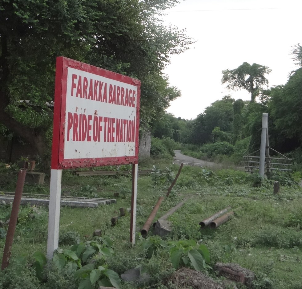
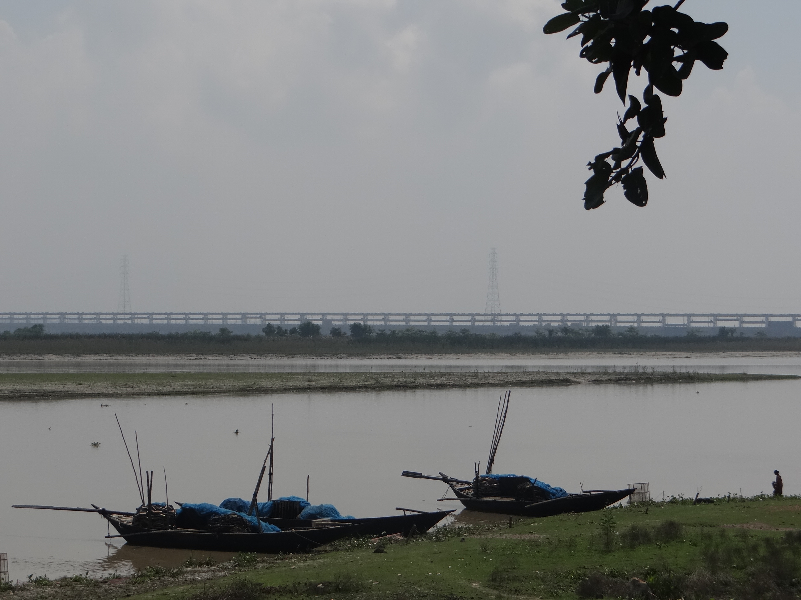
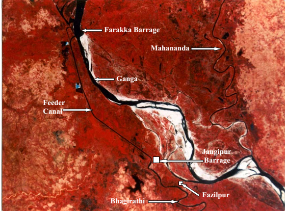
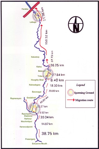
missioning Farakka Barrage in 1975, there are records of the Hilsa migrating from Bay of Bengal right upto Agra, Kanpur and even Delhi covering a distance of more than 1600 kms. Maximum abundance was observed at Buxar (Bihar), at a distance of about 650 kms from river mouth. Post Farraka, Hilsa is unheard of in Yamuna in Delhi and its yield has dropped to zero in Allahabad, from 91 kg/km in 1960s. Studies as old as those conducted in mid-seventies single out Farakka’s disastrous impacts on Hilsa, illustrating a near 100% decline of Hilsa above the barrage post construction.[xiii]

We met fishermen who have not caught a single Hilsa in the upstream of the barrage despite fishing for three days. In the downstream too, size and recruitment (population) of Hilsa is affected due to arrested migration at Farakka. Some 2 million fisherfolk in Bangladesh depend on Hilsa fishing. Hilsa in Padma river (Ganga in India) downstream Farakka has also declined sharply due to decreasing water and blockage of migration routes.[xiv]

Lone Hilsa caught by a fishermen after three days of effort, sold for a pittance to local fish dealer. Photo: Author

These fisherfolk have never been compensated for the losses they suffered. They were not even counted as affected people when the barrage was designed and they are not counted even now.

  1. Fable of Farakka Fish Lock

The tale of Farakka Barrage Fish Lock is another tragic story. Fish Lock is a gated structure in a Barrage that needs to be operated specifically to facilitate migration of fish from the downstream to the upstream or vice versa to breed, feed or complete their lifecycles.

According to Central Inland Fisheries Research Institute (CIFRI), Farakka Barrage has two Fish Locks between gates 24 and 25. The locks need to be operated to aid fish migration and transport fish. We talked with the Engineers at Farakka Barrage Authority, local villagers, fishermen and even the Barrage Control Room officials who operate the gates of the barrage about the functioning of the Fish Lock. No one had heard about a Fish Lock. There is some information that there is one more lock further upstream in the river, but the FBP Authorities did not seem aware of this.

The control room officials kept showing us the ship lock at the Barrage (which is also rarely used due to turbulence and sedimentation) and told us categorically that “There is nothing called as fish lock here”. The locks have not been operated for a minimum of a decade, possibly much longer.

Who is responsible for the loss of fisherfolk income in the meantime? Will the Farakka Barrage Authority or the MoWR or the CWC or the Kolkata Port Trust or Inland Waterways Authority of India compensate them?

Dejected Fisherman upstream Farakka Barrage. He says Hilsa is nearly wiped out from here and there is intense conflict for the meager catch. Photo: Author
Fisherman upstream Farakka Barrage. He says Hilsa is nearly wiped out from here and there is intense conflict for a meager catch. Photo: Author

According to Dr. Parua, fish locks were operated for some time when he was posted at Farakka, but they never worked as planned. He believes that a bare 60 feet fish lock for a barrage that is more than 2.6 kms long is of little use. There should have been more fish locks planned. He also lamented about the non-functionality of Hilsa Fish Hatchery set up at the banks of the barrage. (We were not even told about the presence of this structure by any of the officials or other concerned persons we met and possibly it has now fallen to complete disrepair now.) He said despite Central Inland Fisheries Research Institute (CIFRI) is based in West Bengal and has a special cell to study Hilsa, they or the Fisheries Department have taken no interest in the functioning of the hatchery or the Fish Locks.

2. Vikramshila Dolhin Sanctuary, Bhagalpur

Bhagalpur is barely 150 kms upriver from Farakka and Dr. Sunil Chaudhary, a past Member of the Sate Wildlife Board of Bihar has been working relentlessly on conservation of Gangetic Dolphins, as well as rights of traditional fisherfolk in Bihar and around Vikramshila region.[xv] SANDRP discussed the issue of Farakka and additional barrages with him. Dr. Chaudhary states that not only barrages, but the dredging itself will have serious impacts on Dolphins. Impacts of Farakka Barrage on fish and fisherfolk in Bihar is still being felt. No Hilsa reach here from Farakka and a generation of fisherfolk has suffered due to this. Forget more barrages on the Ganga, we need a review of Farakka Barrage itself as Ganga Mukti Andolan has been asking for years now.

Any work affecting Vikramshila Dolphin Sanctuary will require clearance from State Wildlife Board, State Wildlife Warden and National Board for Wildlife. We hope that such permissions are not given without due diligence and independent application of mind and at least whatever remains of Ganga is maintained.

In conclusion

The issues arising out of Farakka are extremely serious. Our planners and decision makers may claim that many of the impacts were not foreseen (Not entirely true). But the issue cannot be ignored any longer. We need a credible independent review of the development effectiveness of Farakka Barrage, including costs, benefits and impacts.

What we seem to be doing now is to repeat the mistakes of the past with new barrages planned on the Ganga.

The existing Upper Ganga Barrage (Bhimgouda Barrage) has dried up the river in the downstream. The river is diverted in a canal, where people take ritual baths, while the original riverbed is used as a parking lot.

Dry Ganga downstream Upper Ganga, Bhimgouda Barrage in Haridwar Photo: Author

The Lower Ganga (Narora Barrage) has severely affected fish migration & dried up the river in the downstream at least in lean season. The Barrage has a fish ladder, but there is no monitoring or concern as to whether it is working or not. In its report to the World Bank, Uttar Pradesh Government has said that the “condition of the barrage is poor” and has lamented about increased siltation in the upstream of the barrage and the inability to flush the sediments due to poor condition of its gates.[xvi].

Beyond doubt, the existing barrages, especially the Farakka Barrage have had massive impacts on the river, its ecosystems and its people. We have many critical lessons to learn from these experiences. In stead, we are pushing for more barrages on a river which will only compound existing problems.

Ganga is much more than a waterway or a powerhouse. It is a river, supporting not only urban areas and industries, but rural communities, the basin, the ecosystem and myriad organisms in its wake and it needs to be respected as an ecosystem first, rather than for sentimental reasons like mother or goddess.

The Ganga is being fettered at its origin in the Uttarakhand by over 300 hydropower dams. In addition, if it is again dammed many times over times in its main channel, then the government will not have to worry about River Rejuvenation Plan. There will be no river left for rejuvenation.

-Parineeta Dandekar, SANDRP (parineeta.dandekar@gmail.com)

DSC00340

Bibliography:

Dr. Sutapa Mukhopadhyay et al, Bank Erosion of River Ganga, Eastern India –A Threat to Environmental Systems Management

G Verghese, Waters of Hope: Facing New Challenges in Himalaya-Ganga Corporation, India Research Press, 2007

Milliman et al, Environmental and economic implications of rising sea level and subsiding deltas: the Nile and Bengal examples, JSTOR, 1989

Syvitski et al Sinking deltas due to human activities Nature Geoscience, September 2009

Thakkar, Dandekar, Shrinking and Sinking Deltas, Major role of dams in delta subsidence and Effective Sea Level Rise, SANDRP, 2014

A Photo Feature on Farakka Barrage: https://sandrp.wordpress.com/2014/09/29/world-rivers-day-and-ganga-a-look-at-farakka-barrage-and-other-such-calamities/

End Notes:

[1] Pers. Comm.

[i] For a earlier SANDRP report on Farakka, see: https://sandrp.in/dams/impct_frka_wcd.pdf

[ii] http://iwai.nic.in/index1.php?lang=1&level=0&linkid=115&lid=781

[iii] http://timesofindia.indiatimes.com/city/varanasi/No-environmental-clearance-for-Haldia-Allahabad-Waterway/articleshow/39827972.cms

[iv] https://sandrp.wordpress.com/2014/07/08/will-this-ganga-manthan-help-the-river/

[v] http://www.toxicswatch.org/2014/08/work-commencing-on-ganga-waterway.html

[vi] Dr. Rudra, Kalyan, The Encroaching Ganga and Social Conflicts: The Case of West Bengal, India, 2008

[vii] http://timesofindia.indiatimes.com/city/kolkata/PIL-to-save-Kolkata-and-Haldia-ports-filed/articleshow/20526985.cms

[viii] Dr. Rudra, Kalyan, The Encroaching Ganga and Social Conflicts: The Case of West Bengal, India, 2008

[ix] For more details see: https://sandrp.in/Shrinking_and_sinking_delta_major_role_of_Dams_May_2014.pdf

[x] http://www.environmentportal.in/files/Farakka%20Barrage.pdf

[xi] Khalequzzaman, Md., and Islam. Z., 2012, ‘Success and Failure of the Ganges Water-sharing Treaty’ on WRE Forum http://wreforum.org/khaleq/blog/5689

[xii] https://sandrp.wordpress.com/2014/09/01/collapsing-hilsa-can-the-dams-compensate-for-the-loss/

http://wwf.panda.org/wwf_news/?186621/Climate-change-could-drown-out-Sundarbans-tigers—study

http://www.the-south-asian.com/april-june2009/Climate-refugees-of-Sunderbans.htm

http://www.sciencedirect.com/science/article/pii/092181819190118G

[xiii] Ghosh, 1976 quoted in Review of the biology and fisheries of Hilsa, Upper Bengal Estuary, FAO, 1985

[xiv] http://www.downtoearth.org.in/node/2071

[xv] https://sandrp.in/rivers/Dolphins_of_the_Ganga-few_fading_fewer_frolicking.pdf

[xvi] World Bank, Uttar Pradesh Water Restructuring Project Phase II, 2013

[xvii] https://sandrp.in/dams/impct_frka_wcd.pdf

Godavari

Godavari’s Story

Introduction

Godavari, the Dakshin Vahini Ganga, originates at an elevation of 1067 meters in the Brahmagiri Hills of the Western Ghats in Nashik District of Maharashtra and continues its journey over 1465 kms in the south east to meet the Bay of Bengal at Narasapuram in West Godavari district of Andhra Pradesh. Like many Indian rivers, Godavari’s origin is consecrated with a Shiva Temple, the Trimbakeshwar, which is also one of the 12 Jyotirlingas (most of them near a river). And like many other rivers, it has an elaborate myth and a hymn in its honour. The river has a sister, Gautami, right at its origin in Maharashtra and again a distributary called Gautami right where the river falls into the sea in Andhra Pradesh!

Bramhagiri range of Western Ghats where Godavari originates Phot from: shritribakeshwar.blogspot.com
Bramhagiri range of Western Ghats where Godavari originates Photo from: shritribakeshwar.blogspot.com

The river mainstem, longest in Peninsular India, travels through three states, Maharashtra, Telangana and Andhra Pradesh, while its basin includes Madhya Pradesh, Karnataka, parts of Chattisgarh and Odisha. It traverse through 3 agroclimatic zones, 6 agro ecological zones and supports an astounding array of biodiversity and communities. More than 60 million people call Godavari Basin their home. The basin includes important towns like Nashik, Nagpur, Wardha, Nanded and Chandrapur from Maharashtra and Bhadrachalam, Nizamabad, Mancherial & Ramagundam in Telangana, Rajahmundry & Narsapur in Andhra Pradesh and Seoni & Balaghat in Madhya Pradesh.

Idol of Godavari at Brahmagiri, her origin. Photo from: http://dharmanlife.blogspot.in/

The river is considered no less than a sister to Ganga and I remember as a child, elders always referring to Godavari as Ganga. Nashik is important religiously not only as the birth place of this Dakshin Vahini Ganga, where she refused to fall into the Arabian Sea, but also because of the deep association of the city with Ramayana. Nashik was believed to be a part of Dandakaranya where Lord Ram resided for nearly 14 years in Vanavasa. All along the river in places like Tapovan, one can find glimpses of this ancient myth worshipped today. On the banks of Godavari in Nashik also stands the KalaRam Mandir where, in 1930, Babasaheb Ambedkar launched the KalaRam Mandir Entry Satyagraha, storming the temple which was thus far restricted for the depressed classes. Indeed, Godavari has borne witness to several remarkable happenings at her origin itself.

In her middle reaches in Nanded, Takth Sri Hazur Sahib graces the banks of the river where Guru Gobind Singh breathed his last. The place is one of the five holy places in Sikkhism. In Telangana and Andhra too the banks have numerous mosques, temples and ghats of historical significance like Kotilingala in Karimnagar, Telangana, at the confluence of Peddavagu and Godavari. This was the first capital of the Satavahanas circa 230 BC. Most of the important towns in Satavahana era are along the Godavari. Sadly today the Koti Lingala is facing threat of submergence from Sripada Yellampalli Irrigation project. At Dhawaleswaram the river divides into two branches, the Gautami and Vasishta.  Between the two lies the Godavari Central Delta.  The two arms split into branches as they approach the sea dividing the Central Delta into a number of islands.

Anne Feldhaus sums up the historical legacy of many cultures and religions of this upper Godavari Valley and Marathwada eloquently. She says: “This is the area that Cakradhar, the founder of the Mahanubhav sect (circa 12-13th Century), referred to as the “Ganga valley” that is, the (upper) valley of the Godavari, the northernmost of the great rivers that flow from northwest to southeast across the Deccan Plateau. In Cakradhar’s time, what is now Marathwada was the core of the Yadava kingdom, with its capital at Devgiri (subsequently called Daulatabad). Paithan, the capital of the much earlier kingdom of the Satavahanas (first century B.C.E. to third century C.E.) is also found in Marathwada, on the Godavari river, as is Nanded, the site of the grave of the seventeenth-century Sikh leader Govind Singh. The Mughal emperor Aurangzeb’s city, Aurangabad, is now the principal city of Marathwada in Godavari basin, which is also home to the Buddhist (and Jain and Hindu) caves at Ajanta and Ellora (called Verul in Marathi) and to the major Sufi shrines at Khuldabad.” (From: Feldhaus, Anne, in History of Sacred places in India as reflected in traditional literature, Edited by Hans Bakker, 1990)

GOddess GOdavari at Godavar Delta Photo from : http://www.panoramio.com/photo/3342895
Goddess Godavari at Godavari Delta Photo from : http://www.panoramio.com/photo/3342895

Basin Characteristics

(Based on WRIS Basin Profile on Godavari)

Godavari Basin accounts for nearly 9.5% of the total geographical area of the country and extends over states of Maharashtra (48.7%), Andhra Pradesh & Telangana (23.7%), Chhattisgarh (12.4%) and Odisha (5.7%) in addition to smaller parts in Madhya Pradesh (7.8%) and Karnataka (1.4%)

Godavari Basin Map by WRIS
Table-I: Important Tributaries of Godavari
Sr. No. Name of Tributary Length
1 Godavari 1419
2 Purna 382.16
3 Penganga 634.36
4 Wardha 538
5 Wainganga 635.40
6 Pranhita 111.0
7 Indravati 558.96
8 Sabari 179.99
9 Kolab 240.05
10 Pravara 198.79
11 Manjara 198.79

Around 32% of Godavari basin area lies in the elevation zone of 500-750 m. Average annual rainfall (1971-2005) is 1096.92 mm. While the high rainfall zone of Western Ghats the annual rainfall varies from 1000 to 3000 mm region on the east of Western Ghats falls in the rain shadow area which experiences less than 600 mm rainfall.  About 60% of the basin is covered with agricultural land.  Forest area is about 29.78% and water bodies occupy 2.06% of the total basin area.

Sub Basins: The Godavari basin is divided into 8 sub-basins. Principal tributaries are listed in Table-I above.

Geography of the basin: The basin is bounded by the Mahadeo Hills of the Satpura Range in the north, the Western Ghats in the west, Eastern Ghats of the Dandakaranya region of Odisha, Chattisgarh and Andhra in the east. The onterior part of the basin lies in Maharashtra and in a snese the Godavari basin bisects the plateau of Maharasthra.The basin also covers the Vidarbha Plain and the forest covered Wainganga valley. The area is rich in natural vegetation that covers the rugged hilly land.

Wildlife sanctuaries/ Protected areas/ National Parks in the basin: Godavari basin supports significant forest are in the Central India much of this is in the belt of eastern Maharashtra, Chhattisgarh and Telangana states. Wainganga, one of the most important tributary of the Godavari is the stage of Kipling’s Jungle Book. Wainganga basin is home to three tiger reserves viz. Tadoba and Pench National Park in Maharashtra and Indravati National Park in Chhattisgarh. Table-II lists these areas.

Pench National Park in Godavari- Wainganga Basin Photo: Parineeta Dandekar, SANDRP
Table-II: Wildlife sanctuaries/ Protected areas/ National Parks in the basin:
Sr. No. State Wildlife sanctuaries/ Protected areas/ National Parks District
1. Maharashtra Tadoba National Park (Tiger Reserve) Chandrapur
Bor Wildlife Sactuary Wardha
Navegaon Wildlife Sanctuary Gondiya
Nagzira Wildlife Sanctuary Gondiya
Pench National Park (Tiger Reserve) Seoni
2 Chhattisgarh Bhairamgarh Wildlife Sanctuary Dantewada
Kanger Ghati National Park Bastar
Indravati National Park (Tiger Reserve) Dantewada
Pamed Wildlife Sanctuary Dantewada
3 Andhra Pradesh Coringa Wildlife Sanctuary East Godavari
Papikonda Wildlife Sanctuary West Godavari
4 Telangana Kinnerasani Wildlife Sanctuary Khammam
Pocharam Wildlife Santuary Medak
Manjira Bird Sanctuary Nizamabad
Eturnagaram Wildlife Sanctuary Warangal
Kawal Wildlife Sanctuary Adilabad
Siwaram Wildlife Sanctuary Karimnagar
Pranhita Wildlife Sanctuary Adilabad
Siwaram Wildlife Sanctuary Karimnagar
WomenithHilsaYanam
Hilsa from Yanam, Godavari Delta Photo: Indian Express

 Fish and Fisheries in the Basin: Godavari Basin is rich in fish species. The estuarine zone itself is habitat for nearly 228 species, some of which are marine. While the upper stretch of the river is nearly completely dependent on reservoir water releases for fisheries the middle zone has species like Carps, Mahseer, and prawns. Delta, in times of floods and monsoon has rich fisheries of prawns, large sized carps, catfishes, Puntius species, etc. According to CIFRI reports (Selvaraj, 2000, River Godavari: Environment and Fishery, CIFRI), dams like Polavaram will affect a number of species like prawns, which would get severely restricted, Hilsa and carps. The impacts of Polavaram on the lives of thousands of migrating fisherfolk has been documented. Hilsa, or the Pulasa, as it is called in the local language is famed in the estuary.

Major Challenges faced by the Godavari and it inhabitants

1. Dams, Barrages and Anicuts

Dams are a primary challenge faced by a river due to the profound ways in which they affect the hydrology, ecology, sociology, continuum of the river.

According to MoWR (Ministry of Water Resources), so far nearly 921 Dams, 28 Barrages, 18 Weirs, 1 Anicut, 62 Lifts and 16 Powerhouses have been constructed in the basin for irrigation, diversion or, storage purpose. The basin has 70 Major Irrigation Projects and 216 Minor Irrigation Projects.

One of the oldest barrage in the basin as well as the country is the Dowleshwaram Barrage also known as Arthur Cotton Barrage, situated on the Godavari Delta near Rajamundry, Andhra Pradesh. Godavari barrage has come up by remodeling the Dowleshwarmam barrage and irrigates the Godavari Delta. The barrage does not have a fish lift or a pass and does not releases eflows in the downstream, starving the delta of sediment and water and blocking migration of the fames Pulasa, Hilsa fish.

Dowleswaram barrage just upstream bifurcation of Godavari into Gautami and Vashitha Photo: The Hindu

Other important projects include Sri Ram Sagar Project or the Pochampadu project in Nizamabad, Telnagana and the Jayakwadi Project in Paithan, Maharahstra. Jayakwadi project boasts of the one of the longest dam walls in the country, running more than 10 kms, which has resulted in massive evaporation losses from the reservoir. The project was built displacing 70 villages and is now in the eye of the storm as intra state water disputes heat up in Maharashtra. In the upstream of Jayakawadi are more than 11 large dams in the districts of Nashik and Ahmednagar, which is a cane and grape growing region. Downstream Jayakawadi too are several projects on the Godavari and tributaries in Maharashtra like 11 barrages on Godavari, Vishnupuri, Upper Penganga, etc.  The massive GosiKhurd Dam coming up on Wainganga River, one of the biggest tributary of Godavari, is mired is corruption charges. The project will submerge more than 100 villages and is witnessing stiff resistance from the region.

Waterbirds on mudflats of Jayakwadi Dam Photo: Wikimedia Commons

The Nizamsagar multipurpose project is constructed in Nizamabad district in Telengana on Manjira River in 1931. Kaddam Reservoir is constructed on the Kaddam River in Adilabad district of Andhra Pradesh. The dam broke in a year after construction in 1958, by 4.6 cms water flowing over the crest.[1] Upper Indravati multipurpose project on the Indravati in Odisha diverts waters of the Indravati into the Mahanadi for power generation. Upper Kolab dam was completed in 1990 on Kolab River, Orissa, it has a live storage capacity of 935 MCM. At FRL, the reservoir water spread covers 114 sq. km. The dam displaced more than 50,000 people in the Koraput district of Odisha, who were already distressed by a number projects in Odisha. Hydro projects in the Sileru river, a tributary of Godavari in Odishna has displaced thousands of tribals till date. Thee projects include Machkund (120 MW), Balimela (510 MW), Upper Sileru (240 MW), Donkarayi (25 MW) and Lower Sileru hydro (460 MW) power project.

According to this disturbing report, about 20,000 people from 6 grampanchayats, predominantly tribal are cut off from the main land for several years, first by the Machkund Hydro electric project and then by Balimela Project. They hire a ferry to get to mainland and in 2010, this ferry was targeted and attacked by the maoists.

tribals trying to get aboard the only motor launch thats their link to the main land after being cut off by Machkund and Balimela Dams. Photo from : http://moonchasing.wordpress.com/2010/03/14/forgotten-country-the-cut-off-area-of-malkangiri/
Tribals trying to get aboard the only motor launch thats their link to the main land after being cut off by Machkund and Balimela Dams. Photo from : http://moonchasing.wordpress.com/2010/03/14/forgotten-country-the-cut-off-area-of-malkangiri/

godavari

Surplus basin or Deficit Basin? Surprisingly. although there is a severe water scarcity in many parts of the basin, leading to increasing conflicts, the National Water Development Agency, responsible for works related to Interlinking of Rivers, classifies Godavari as a Surplus Basin and plans diversions from Godavari into other basins like Krishna and Pennar. Ironically, in Maharashtra, there are projects underway to transfer water from Krishna to Godavari!( Krishna Marathwada Lift Irrigation Project).

The situation only highlights the fallacies of labeling river basins “Surplus”  or “Deficit”. Maharashtra is in fact already transferring water from west flowing basins into Godavari, in a very unscientific manner.

Sedimentation of the river upstream Sri Ram Sagar Project. Dams trap sediments, decreasing their live storage capacities, while starving the river downstream and killing the delta Photo from: The Hindu

2. Upcoming projects and Major Struggles:

The basins is also witnessing massive conflicts over water. Perhaps Godavari is the first basin in the country to witness a long drawn and oft repeated intrastate water conflict between stakeholders upstream of Jayakwadi and those downstream. The conflict does not seem to subside with entrenched positions, proliferation of water intensive crops like sugarcane and lack of open communication and transparency from the administration. Lower Penganga project, which is set to displace more than 20 villages in the fertile belt of Yavatmal is also witnessing a huge protest against the dam project. Gosikhurd project on Wainganga too is witnessing massive struggle not only from the farmers upstream, but also fisherfolk who fish in the rich Wainganga at present. The upcoming Pranahita-Chevella link, a part of the Jalyagnam project in the present Telanagana is likely to see conflicts as Maharashtra appears to be the loser, losing forest lands, protected area and tribals villages for no tangible gains. Already, water sharing conflicts between newly formed Telangana and Andhra Pradesh are on the anvil.

Protest against Gosikhurd dam Photo from sruti.org.in
Tribals from Odishna, Andhra and Chattisgarh oppose Polavaram Photo: The Hindu

Jalyagnam project,  an intricate plan of over 78 dam projects and lift irrigation schemes mostly on Godavari has also been in the eye of the storm for huge corruption charges, massive displacement and contractor-friendly nature, ignoring the deep impacts on the river and its people.

Other planned projects include: Polavaram, a project which can submerge 276 villages in Telangana, Odisha and Madhya Pradesh, displacing nearly 1,50,000 people! The EIA of the project was majorly flawed, the Public Hearing was rigged and there is huge local opposition to the project. Hydel projects like Bhopalpatanam and Ichampalli projects on Indravati River can submerge near nearly 2 lakh acres of land, mostly forest land[2].

3. Godavari Water Disputes Tribunal: In April 1969, the Central Government constituted the Godavari Water Disputes Tribunal (GWDT) to address water sharing disputes between Maharashtra and Andhra Pradesh. While the disputes were before the Tribunal, the party States themselves, after  negotiations  entered into  agreements  from  time  to  time  on  the  utilisation  of  the  waters  of  the  Godavari and its tributaries. Incorporating these agreements in the final adjudication GWDT gave the final verdict in the year 1980 and ordered that the agreements should be observed and carried out by all concerned. Different sub-basins from the catchments  intercepted  by  major/medium  projects  proposed  on  various  tributaries by  the  States  have  been  generally allocated  among  the  respective  States. However GWDT verdict lacks actual water use monitoring mechanism to implement the agreements in true spirit[i]

4. Water Quality and Pollution:

Like all rivers across India, Godavari too faces severe pollution from urban and rural sewage, agricultural runoff, and industrial effluents. In Maharashtra upper stretch of Godavari from Nashik District to Paithan has been declared as priority I critically polluted stretch by CPCB with BOD ranging from 6 mg/l to 36 mg/l[ii]. A petition has been filed in the high court by few activists from the city against Nashik Municipal Corporation (NMC), Municipal Commissioner, Government of India (GoI), Government of Maharashtra (GoM), and Maharashtra Industrial Development Corporation (MIDC) for failure on their part to clean the pollution of the river[iii].

Godavari polluted at the source in Nashik Photo: Tripadvisor

In Andhra Pradesh stretch flowing from District of Rajamundry has been declared as priority-IV critically polluted stretch with BOD 6 mg/l.

Water quality of Manjara from Latur city in Maharashtra to Karnataka border and also at Sangareddy, at Wardha’s confluence with river Pangangato downstream of Sirpur in Maharashtra and of Indravati at Bodhghat in Madhya Pradesh has been deteriorated.In Vidarbha, the several thermal power plant, including the ones run by the state discharge fly ash and highly contaminated wastes right into the tributaries of the basin.

5. Subsiding Delta due to upstream dams:

The Godavari and Krishna rivers, which are the second and third largest river systems in India after the Ganga, have built their deltas adjacent to each other almost merging into one large delta complex in the central part of the east coast of India.This delta is one of the most fertile and is a densely populated zone of intense economic activity. Delta plain of the river Godavari occupies an area of 1700 sq.km. River Godavari gets divided into two main distributaries, viz. Gautami and Vasishta.

Coringa Wildlife Sanctuary is situated on the deltaic branches of Gouthami and Godavari rivers at Kakinada Bay. It has extensive marshes and mangroves extending in an area of about 235.Sq.Kms

There  has  been  almost  a  three-fold  reduction  in  suspended sediment  loads  entering the delta due to trapping from upstream dams. This is leading into coatsla erosion, Effective Sea Level Rise, more flood risks, fisheries reduction, etc. Sediment load at the delat has reduced from  150·2  million  tons  during  1970–1979  to  57·2  million  tons  by  2000–2006. Experts like Syvistki et al classify Godavari delta as  “Deltas in greater risk: reduction in aggradation where rates no  longer  exceed  relative  sea-level  rise”.    Decline  in  historic sediments of Godavari post damming has been as high as 74%!

Children and Godavari Photo with thanks from: https://www.flickr.com/photos/32835899@N07/3855165595

Winding up

From the origin in Western Ghats to its mouth at the Eastern coast, Godavari traverses a major part of Peninsular India and nourishes several rich cultures and social milieus: from Marathi in Deccan plateau to ancient tribal culture in central India to a vibrant delta system near Rajamundhry. The River is fettered in many dams all along its length and across its basin which have been responsible for human sufferings, ecological impacts, livelihood struggles and conflicts.

The basin is facing several major issues, but the river is also resilient. Let us hope that inhabitants of the Godavari basin are empowered to solve the problems of their river.

-Parineeta Dandekar ( parineeta.dandekar@gmail.com)

Amruta Pradhan (amrutapradhan@gmail.com)

Both of us are from Nashik, the origin of Godavari!

~~~~

The Profile is largely based on data from following sources:

India WRIS Wiki: Godavari (http://india-wris.nrsc.gov.in/wrpinfo/index.php?title=Godavari)

Major Water Resources Development Projects in the Godavari Basin (http://www.nih.ernet.in/rbis/india_information/GODAVARI_projects.htm)

http://www.sakti.in/data-base-on-godavari-basin

End Notes:

[1] http://nptel.ac.in/courses/105106114/pdfs/Unit41/41_2.pdf

[2] http://www.narmada.org/AMTE/vanaprastha3.html

[i] “GODAVARI RIVER WATER SHARING ACCORD” by N. Sasidhar

[ii] Annual Report 2009-2010 of Central Pollution Control Board

[iii] Bombay High Court order issued on 07/03/2014 for PIl-176.12

Further Reading:

Ecology of the river by Infochange News & Features, November  2010 (http://infochangeindia.org/environment/fishing-in-troubled-waters/ecology-of-the-river.html)

Nagpur 24×7 water supply at the cost of irrigation potential? by Amruta Pradhan (https://sandrp.wordpress.com/2014/07/25/nagpur-24×7-water-supply-at-the-cost-of-irrigation-potential/)

Goda Park Riverfront Development Project: Violation of court order and destruction of fertile riparian zone by Amruta Pradhan (https://sandrp.wordpress.com/2014/11/03/goda-park-riverfront-development-project-violation-of-court-order-and-destruction-of-fertile-riparian-zone/)

One state, but divergent demands by Parineeta Dandekar (http://indiatogether.org/share-environment)

Dam’ned: A Film on Polavaram Dam Give Voice to the Unheard By Parag Jyoti Saikia (https://sandrp.wordpress.com/2014/02/07/damned-a-film-on-polavaram-dam-give-voice-to-the-unheard/)

Agitation against Polavaram by SANDRP (https://sandrp.in/dams/polavrm_article.pdf)

Hydropower Generation Performance in Godavari Basin by SANDRP (https://sandrp.in/HEP_Performance/HEP_Performance_in_Godavari_River_Basin_Dec_2011.pdf)

brahmaputra · Dams · Hydropower

WRIS River Basin Reports: Hits and Misses

Reliable data and information that is both correct and validated on ground, is a pre requisite to understand any feature or activity. And for a river, a constantly evolving and truly complex entity, it becomes even more crucial. The wellness quotient of rivers, their present health status, all these and more can only be understood, once we have the rudimentary knowledge of the river and the basins that they form.

A step in this direction has been taken up by the India WRIS (Water Resources Information System) project (A joint venture between Central Water Commission and Indian Space Research Organisation), that aims “to provide a ‘Single Window Solution’ for water resources data & information in a standardized national GIS framework”[i]. This project has generated 20 basin level reports that share important information on the salient features of the basin, their division into sub basins, the river systems that flow through it and the water resource structures, such as irrigation & hydro electric projects in the basin. Another crucial inclusion is the length of major rivers in each basin, which have been GIS calculated (Geographic information system)[ii] and in a few reports the place of origin of the rivers too is mentioned. (Ganga Basin Report). This is an improvement over the earlier documented river lengths that included the canal length along with the river lengths, in earlier CWC documents (e.g. water and related statistics)!

The Basin reports include basin level maps which also show the proposed inter basin transfer links and the major water resource structures & projects. Individual maps at the sub basin level mark the rivers & their watersheds. The report gives details on the topography, climate, the land use / land cover area , and also the information on hydro meteorological stations like groundwater observation cells, flood forecasting sites and even water tourism sites.

These reports can be downloaded from the WRIS site.[iii]

The reports are an attempt to document the water resources data & information for a better and more integrated planning, at the basin level. A table below tabulates some important parameters from the 20 basin reports.

Missing Dams! It can be seen from table on next page that total number of dams in all the 20 basins come to 4572. Assuming that this includes all the completed large dams in India by Dec 2013 (WRIS report is dated March 2014), if we look at the number of large dams  in India as in Dec 2013 in the National Register of Large Dams (NRLD), the figure is 4845. This leaves a difference of 273 large dams, which are missing from the WRIS list! This seems like a big descripancy. Unfortunately, since NRLD gives only statewise list and does not provide river basin wise list and since WRIS list provides only river basin wise list and does not provide the names of districts and states, it is not possible to check which are the missing dams, but WRIS need to answer that.

Sub Basins These 20 basins have been further delineated into a number of sub basins. The sub basins details include the geographical extent of the sub basin, the rivers flowing in it, the states that they travel through, number and size range of watersheds and also the details of dams, weirs, barrages, anicuts, lifts & power houses, accompanied by maps at this level. The irrigation and hydro electric projects in the area are detailed and mapped for greater convenience. The sub basin list is given here to get a detailed picure.

Indus Basin Sub-basins:

River Dras in Indus Basin in Jammu and Kashmir (Photo by Sabita Kaushal)
  1. Beas Sub Basin
  2. Chenab Sub Basin
  3. Ghaghar and others Sub Basin
  4. Gilgit Sub Basin
  5. Jhelum Sub Basin
  6. Lower Indus Sub Basin
  7. Ravi Sub Basin
  8. Shyok Sub Basin
  9. Satluj Lower Sub Basin
  10. Satluj Upper Sub Basin
  11. Upper Indus Sub Basin
S. No River Basin Major river No. of sub basins No. of watersheds No. of water resource structures No. of water resource projects
Irrigation Hydro  Electric
Dams Barrages Weirs Anicuts Lifts Power Houses Major Medium ERM*
1 Indus (Upto border) Indus (India) 11 497 39 13 18 0 45 59 30 40 21 55
2a Ganga Ganga 19 980 784 66 92 1 45 56 144 334 63 39
b Brahmaputra Brahmaputra (India) 2 180 16 17 5 0 4 21 9 13 3 17
c Barak & others basin Barak 3 77 4 3 0 0 0 3 0 6 3 3
3 Godavari Godavari 8 466 921 28 18 1 62 16 70 216 6 14
4 Krishna Krishna 7 391 660 12 58 6 119 35 76 135 10 30
5 Cauvery Cauvery 3 132 96 10 16 9 24 16 42 3 15
6 Subernarekha Subernarekha & Burhabalang 1 45 38 4 12 0 0 3 5 34 0 1
7 Brahmani & Baitarni Brahmani & Baitarni 2 79 61 5 4 1 0 1 8 35 4 1
8 Mahanadi Mahanadi 3 227 253 14 13 0 1 6 24 50 16 5
9 Pennar Pennar 2 90 58 0 1 2 0 1 7 14 0 1
10 Mahi Mahi 2 63 134 0 4 0 0 3 10 29 3 2
11 Sabarmati Sabarmati 2 51 50 2 10 0 0 0 9 11 4
12 Narmada Narmada 3 150 277 2 2 0 4 9 21 23 1 6
13 Tapi Tapi 3 100 356 8 11 0 13 2 13 68 2 1
14 WFR Tapi to Tadri Many independent rivers flowing 2 96 219 0 3 0 1 18 13 15 1 12
15 WFR Tadri to Kanyakumari 3 92 69 6 6 4 0 29 19 12 7 21
16 EFR  Mahanadi_ Pennar 4 132 64 5 12 12 0 0 12 46 10 0
17 EFR Pennar _ Kanyakumari 4 165 61 2 2 11 0 6 13 33 4 5
18 WFR Kutch _ Saurashtra Luni 6 268 408 1 10 0 0 0 8 100 4 15
19 Area of inland drainage in Rajasthan Many independent rivers flowing 1 0 0 0 48 0 11 1 1 0
20 Minor rivers draining into Myanmar(Burma) & Bangladesh Many independent rivers flowing 4 54 3 5 0 0 3 3 4 1
  Total 94 4335 4572 203  335

* Extension, Renovation and Modernization                                                                                                                                  ** Data has been accumulated from the individual Basin Reports from India WRIS[iv]

Ganga Basin

  1. Yamuna Lower
  2. Yamuna Middle
  3. Yamuna Upper
  4. Chambal Upper
  5. Chambal Lower
  6. Tons
  7. Kosi
  8. Sone
  9. Ramganga
  10. Gomti
  11. Ghaghara
  12. Ghaghara confluence to Gomti confluence
  13. Gandak & others
  14. Damodar
  15. Above Ramganaga Confluence
  16. Banas
  17. Bhagirathi & others ( Ganga Lower)
  18. Upstream of Gomti confluence to Muzaffarnagar
  19. Kali Sindh and others up to Confluence with Parbati

Brahmaputra Basin It is strange to see that the profile divides this huge basin into just two sub basins, when it could have easily divided into many others like: Lohit, Kameng, Siang, Subansiri, Tawang, Pare, Teesta, Manas, Sankosh, among others.

  1. Brahmaputra Lower
  2. Brahmaputra Upper

Barak & Others Basin

  1. Barak and Others
  2. Kynchiang & Other south flowing rivers
  3. Naochchara & Others

Godavri Basin

  1. Wardha
  2. Weinganga
  3. Godavari Lower
  4. Godavari Middle
  5. Godavari Upper
  6. Indravati
  7. Manjra
  8. Pranhita and others

Krishna Basin

  1. Bhima Lower Sub-basin
  2. Bhima Upper Sub-basin
  3. Krishna Lower Sub-basin
  4. Krishna Middle Sub-basin
  5. Krishna Upper Sub-basin
  6. Tungabhadra Lower Sub-basin
  7. Tungabhadra upper Sub-basin
Srisailam Dam on Krishna River (Source: Wikipedia)

Cauvery Basin

  1. Cauvery upper
  2. Cauvery middle
  3. Cauvery lower

Subernarekha Basin No sub-basins.

Brahmani & Baitarani Basin

  1. Brahmani
  2. Baitarani

Mahanadi Basin

  1. Mahanadi Upper Sub- basin
  2. Mahanadi Middle Sub- basin
  3. Mahanadi Lower Sub- basin

Pennar Basin

  1. Pennar Upper Sub-basin
  2. Pennar Lower Sub-basin

Mahi Basin

  1. Mahi Upper Sub-basin
  2. Mahi Lower Sub-basin

Sabarmati Basin

  1. Sabarmati Upper Sub- basin
  2. Sabarmati Lower Sub-basin

Narmada Basin

  1. Narmada Upper Sub-basin
  2. Narmada Middle Sub-basin
  3. Narmada Lower Sub-basin

Tapi Basin

  1. Upper Tapi Sub- Basin
  2. Middle Tapi Sub- Basin
  3. Lower Tapi Sub- Basin

West flowing rivers from Tapi to Tadri Basin

  1. Bhastol & other Sub- basin
  2. Vasisthi & other Sub- basin

West flowing rivers from Tadri to Kanyakumari Basin

  1. Netravati and others Sub- basin
  2. Varrar and others Sub- basin
  3. Periyar and others Sub- basin

East flowing rivers between Mahanadi & Pennar Basin

  1. Vamsadhara & other Sub- basin
  2. Nagvati & other Sub- basin
  3. East Flowing River between Godavari and Krishna Sub- basin
  4. East flowing River between Krishna and Pennar Sub- basin

 East flowing rivers between Pennar and Kanyakumari Basin

  1. Palar and other Sub-basin
  2. Ponnaiyar and other Sub-basin
  3. Vaippar and other Sub-basin
  4. Pamba and other Sub-basin

West Flowing Rivers of Kutch and Saurashtra including Luni Basin

  1. Luni Upper Sub-basin
  2. Luni Lower Sub-basin
  3. Saraswati Sub-basin
  4. Drainage of Rann Sub-basin
  5. Bhadar and other West Flowing Rivers
  6. Shetrunji and other East Flowing Rivers Sub-basin

Area of inland drainage in Rajasthan Due to very flat terrain and non-existence of permanent drainage network, this basin has not been further sub divided.

Minor rivers draining into Myanmar and Bangladesh

  1. Imphal and Others sub basin
  2. Karnaphuli and Others sub basin
  3. Mangpui Lui and Others sub basin
  4. Muhury and Others sub basin

Narmada Basin: Some details To understand the compiled information at the basin level, we take a look at the one of the basin level reports, the Narmada Basin Report[v] (dated March 2014) as an illustrative example. An overview of the basin area right at the beginning, gives its geographical location, shape, size, topography, climate & population. This basic relevant information is tabulated in a concise table for easy access, as given below:

Salient Features of Narmada Basin from WRIS Basin Report

River information The major river flowing in the basin, the Narmada River (also called Rewa) that flows through the 3 states of Madhya Pradesh, Maharashtra & Gujarat, its length (1333 km) and the length of its 19 major tributaries out of a total of 41 is given, based on GIS calculations. There is also a clear river network map of the Narmada basin that demarcates the 3 sub basins along with the watersheds, and shows the dams / weirs /barrages and the rivers in the basin.

Narmada Basin Report Cover Page (Source: WRIS)
  • Narmada Upper Sub-Basin, with 16 watersheds
  • Narmada Middle Sub-Basin, having 63 watersheds
  • Narmada Lower Sub-Basin, with 71 watersheds

The surface water bodies details include the size (less than 25 ha to more than 2500 ha) and type (Tanks, lakes, reservoirs, abandoned quarries or ponds) of existing bodies. Nearly 91.8% of these are tanks.

Irrigation Projects The water resource projects in the basin are as follows:

  • 21 Major Irrigation Projects
  • 23 Medium Irrigation Projects
  • 1 ERM Project
  • 6 Hydro-Electric Projects

Interestingly description is only of the major and medium irrigation projects, information on minor projects is completely absent. An attempt to include the details of minor irrigation projects would have made the report more useful. The reports seem to not understand the significance of the smaller projects  and their importance for the people and in the conext of the River Basin too.

Water resource structures The number and type of big manmade structures in the basin is given. These are a total of 277 dams, 2 barrages, 2 weirs and 4 lifts, of which again the major structures are marked on a map, and details given as in table below. Dams are classified on the basis of storage and purpose they are used for, and the dam numbers are available at sub basin level.

Narmada Sub Basin details from WRIS Basin Report

The report gives tabulated data for each of the dams, which is supposed to have name of the river, height, length, purpose, year of commissioning, etc. Since GIS is the strength of ISRO, they could have easily given latitude and longitudes of each dam, but they have not. Shockingly, in case of 186 of the dams, name of the river on which it is built is given as ‘Local Nallah’, and in case of 10 they have left the column blank. This means for nearly 71% (196 out of 277) of the dams they do not even know the name of the river they are build on. This is actually an improvement over the performance of CWC. The CWC’s National Register of Large Dams[vi], we just checked, mentions Narmada only 13 times (for 12 dams of Gujarat and 1 dam of Madhya Pradesh).[vii]

It is well known that Narmada Basin is the theatre of India’s longest and most famous anti dam movement, Narmada Bachao Andolan. The movement involves opposition to Sardar Sarovar, Indira Sagar, Omkareshwar, Maheshwar, Jobat dams, among others. Such social aspects should also form part of any river basin report.

 Surface water quality There are 19 surface water quality observation sites in the basin, that collect water data and the report spells out , “As compared to the other rivers, the quality of Narmada water is quite good. Even near the point of origin, the quality of river water was in class ‘C’ in the year 2001 while it was in class ‘B’ in earlier years. As was observed for most other rivers, in case of Narmada also, BOD and Total Coliform are critical parameters.” This shows that even in Narmada Basin, water quality is deteriorating. The statement also remains vague in absence of specifics.

Inter basin transfer links Details of the Par-Tapi-Narmada Link, which is a 401 km long gravity canal and its proposal to transfer 1,350 MCM (Million Cubic metre) of water from ‘surplus rivers’ to ‘water deficit’ areas is given, along with a map. How has the conclusion of surplus or deficit been reached? Does the assessment exhaust all the options including rainwater harvesting, watershed development, groundwater recharge, better cropping patterns and methods, demand side management, optimising use of existing infrastructure, etc? Is this is the least cost option? Does the water balance include groundwater? Who all will be affected by this or even how much land area will be affected by this proposal, there is absolutely no talk of this? No answers in the report.

India River Basins Map (Source - WRIS)
India River Basins Map (Source – WRIS)

There’s more to a river There is no information in basin reports on the regulating or statutory bodies that have a say in the basin in the report. However, some information on the existing organisations and inter-state agreements at the various basin level is given at another WRIS location.[viii]

 The Basin reports for 20 basins are clearly an asset for understanding and analysing water resource situation. However, there is no mention of the numerous ecological, social and environmental services these rivers provide us with. The demographic details of the basin are available, but there is no information on the flora and fauna, who also need and thrive on the river waters. A good navigation tool for water resource information and river management projects at basin level, nevertheless, for a broader and more comprehensive outlook these reports should have included the following essential aspects too:

  • River status: The present water quality & pollution level of the major rivers as well as their tributaries
  • River governance: The local committees, civil bodies and institutions that play a role in river basin development
  • River safety measures: Effect of the existing and planned river management projects on the state of the river, people and society.
  • River ecology: Status of biodiversity, and other ecological aspects of the rivers

Sabita Kausal, SANDRP (sabikaushal06@gmail.com

END NOTES:

[i] India WRIS: http://india-wris.nrsc.gov.in/wrpinfo/index.php?title=Main_Page

[ii] GIS: http://en.wikipedia.org/wiki/Geographic_information_system

[iii] http://india-wris.nrsc.gov.in/

[iv] Basin Reports available for download: http://india-wris.nrsc.gov.in/

[v] http://india-wris.nrsc.gov.in/Publications/BasinReports/Narmada%20Basin.pdf

[vi] http://www.cwc.nic.in/main/downloads/New%20NRLD.pdf

[vii] For more details, see: https://sandrp.wordpress.com/2013/03/14/how-much-do-we-know-about-our-dams-and-rivers/

[viii] http://india-wris.nrsc.gov.in/wrpinfo/index.php?title=Basins

Ganga · Hydropower · Uttarakhand

Why is the IIT Consortium acting like a hydropower lobby?

In a shocking development, Consortium of Indian Institute of Technology (IITC) has submitted a report that is a shot in the arm for the hydropower lobby in Ganga basin in Uttarakhand. This IITC report is being used by the Union Ministry of Environment, Forests and Climate Change (MoEF&CC) to push ahead 24 Hydropower Projects in Uttarakhand which were recommended to be cancelled by two official expert reports, both commissioned on the orders of the Supreme Court of India. It seems the authors of the IITC report are jeopardizing the formidable reputation of the IITs and over a dozen other institutes which are a part of IITC, possibly for some short term gains.

Sounds ridiculous? Read on..

WII report The first expert report mentioned above is the report of the Wildlife Institute of India (WII), commissioned by the MoEF & CC to assess the cumulative impact of some 70 hydropower projects in Alaknanda-Bhagirathi basin in Uttarakhand. WII submitted the report to MoEF&CC in April 2012 and among other recommendations, said that 24 of these projects should be dropped due to their irreversible & long term impact on aquatic and terrestrial biodiversity. At the outset it should be mentioned that the WII (“an internationally acclaimed”, “autonomous institute of MoEF&CC”, see: http://www.wii.gov.in/) recommendation of dropping 24 projects was based on assessment of aquatic and terrestrial biodiversity impacts of the series of hydropower projects in Bhagirathi-Alaknanda basins in Uttarakhand. WII was commissioned to do this study by the MoEF&CC following an earlier SC order based on CEC (Central Empowered Committee) recommendation.

MoEF&CC, did not want to take the recommended action, so it sat on the recommendation of the WII report.

EB report following SC directions to Ministry to take stand on WII report On Aug 13, 2013, following the Uttarakhand disaster of June 2013, the Supreme Court directions, among other things included, “MoEF is directed to examine, as noticed by WII in its report, as to whether the proposed 24 projects are causing significant impact on the biodiversity of Alaknanda and Bhagirath River basins.” Again, MoEF&CC did not want to do any such examination on its own. Since MoEF&CC was setting up an expert body to examine the role of hydropower projects in the Uttarakhand disaster as per other directions of the same SC order of Aug 13, 2013, the ministry included such examination also in the Terms of Reference of the Expert Body (EB) under chairmanship of Dr Ravi Chopra.

The EB terms of reference were even wider than that of WII study and the expertise available with EB was also wider. With such expertise and terms of reference, the EB report (by 11 of the 13 members of EB) submitted to MoEF&CC in April 2014 came to the conclusion that 23 of the 24 projects in WII list should be dropped and even the 24th project, namely the Kotli Bhel 1A should go ahead only after significant modifications. Thus, essentially, EB too endorsed the WII recommendation.

It should be noted here that the WII recommendations were peer reviewed (during the work of Expert Body in 2013-14) by renowned biodiversity expert Dr Brij Gopal. Dr Brij Gopal too endorsed WII recommendation that the 24 projects should be dropped. The peer review was sought by the Central Water Commission representative at the 2nd EB Meeting. Despite objections from some EB members, the Chairman agreed to such a review and proposed the name of Dr. Brij Gopal which was promptly seconded by the Vice-Chairman, Dr. B.P. Das – a former Chief Engineer (Irr), Govt of Odisha and former Vice Chairman of the MOEF&CC’s Expert Appraisal Committee on River Valley Projects. In fact Dr. Brij Gopal suggested that more projects needed to be dropped.

MoEF&CC still did not want to take action on the 24 projects. So using the dissenting report by two government agencies which were largely toeing their official position in EB, the MoEF&CC suggested to the Supreme Court of India on May 7, 2014 that it wants to set up another committee. Seeing no validity in this, the Honorable SC rejected this suggestion and asked MoEF&CC to take a stand. SC has also since then put a stay on any further work on these 24 projects.

Still not ready to take a stand, MoEF&CC, used the reason that since IITC was already working on Ganga River Basin Management Plan (GRBMP) for the ministry since 2010 went ahead and gave the task of reconciling the two EB reports to IITC. In effect this is tantamount to violating the SC directions of not appointing another committee. However, unlike the picture it tried to give to SC, this task was not part of GRBMP work, but given to IITC through a fresh TOR.

Perturbed at not receiving any serious required response from MoEF&CC after repeated orders, the apex court judges of the Supreme Court rightly said the ministry was behaving like Kumbhakarna and Rip Van Winkle.

On Oct 9, 2014, the MoEF&CC submitted an affidavit to the SC, relying entirely on a report from IITC. And lo and behold, IITC had provided a report to the MoEF&CC, certifying that with some vaguely defined criteria, all the 24 projects can go ahead and there is no need to cancel any project! Serendipitously, this is exactly what the MoEF&CC & the hydropower lobby wanted!

It needs to be stated here that IITC had no mandate to submit such a report and the report is unprofessional, inadequate, unwarranted and inconsistent.

Let us see how.

Authors of the IITC report IITC report was authored by eight persons: Dr Vinod Tare (Civil Engineering Dept, IIT Kanpur, see: http://www.iitk.ac.in/ce/CIVIL/faculty.htm), Dr I M Mishra (Department of Chemical Engineering, IIT Roorkee, see: http://www.iitr.ac.in/departments/CH/pages/People+Faculty+imishfch.html#), Dr Purnendu Bose (Civil Engineering Department, IIT Kanpur, see: http://www.iitk.ac.in/ce/CIVIL/faculty.htm), Dr Ligy Philip (Civil Engineering Dept, IIT Madras, see: http://www.civil.iitm.ac.in/people/faculty/ligy/about.html), Dr B S Murty (Civil Engineering Dept, IIT Madras, see: http://www.civil.iitm.ac.in/?q=murty_edu), Dr R P Mathur (formerly Prof of Civil Engineering, University of Roorkee), Dr M Jawed (Dept of Civil Engineering, IIT Guwahati, see: http://www.iitg.ac.in/jawed/homepage/index.html) & Dr Gautam Roy (Consultant GRBMP and former student of Civil Engineering Department at IIT Kanpur). A perusal of the available information on professional background of these persons shows that none of them have expertise on the aquatic and terrestrial biodiversity of the Bhagirathi-Alaknanda basin, to decide on the appropriateness of the WII recommendations. Hence at the outset it seems inappropriate for IITC to sit on judgment over recommendation of an expert body, on subject matter of which IITC has no expertise.

The IITC team of 8 persons listed above, all with essentially engineering background have now also reviewed the EB report and made their own recommendations, again without having the expertise that was available at EB command. It is thus inappropriate for IITC to comment on the recommendations of the EB which had two biodiversity experts from FRI (Forest Research Institute) and WII, besides experts from Uttarakhand in various other disciplines. IITC is thus being unprofessional.

What does IITC report say The IITC report essentially says that ALL the 24 projects can go ahead if they satisfy three criteria: Aviral Dhara, Environmental flows and longitudinal connectivity. The first thing that strikes about these three terms is that they are all vaguely defined and can have flexible interpretations. They are also interconnected and not necessarily independent of each other. Most importantly, they do not take care of the issues based on which the two expert reports said that these 23 projects should be dropped and even the 24th Project, namely the Kotli Bhel 1A may be dropped or modified. But first let us understand these three vaguely defined, flexible and interconnected terms.

Aviral Dhara: According to the IITC report para 2.1 (see also: “Ganga River Basin Management Plan Extended Summary” of June 2014 available at: http://gangapedia.iitk.ac.in/sites/default/files/2014-06-12_GRBMP_Extended%20Summary.pdf): “Aviral Dhara in this context means that the flow of water, sediments and other natural constituents are continuous and adequate over the entire length of the river throughout the year.” There is no definition of what is adequate here, nor it is clarified as to adequacy is from what point of view. Here it should be noted that Aviral literally means uninterrupted, but neither IITC nor MOEF&CC provide this interpretation. According to MOEF&CC affidavit of Oct 9, 2014 (para 8(c)), Aviral means “to flow round the clock” or “continuous flow”.

Environment Flows: For Environmental flows, the “objective” of GRBMP is (see p 9 of the GRMBP Extended Summary) “Environmental Flows shall be maintained in all rivers and tributaries of Ganga River System to fulfill their geological, ecological, socio‐economic and cultural functions.” The E-flows thus would than depend on identifying functions of the river from geology, ecology, socio-economic and cultural perspectives, which can vary. The GRMBP extended summary does not provide clarity on e-flows for any of these aspects and how to go about arriving at required environment flow. It should be mentioned here that to arrive at environment flows, there are about 200 methodologies available globally. The IITC report attached with the MOEF&CC affidavit remains even vaguer as it says maintenance of E-flow should lead “to river stability and ecological balance in the downstream areas.”

Clarity on environmental flows is crucial as the affidavit from MOEF&CC itself agrees that MOEF&CC did not address the issue of eflows adequately while granting environmental clearances in Uttarakhand. One of the basic reasons behind this was lack of clarity on the issue and the same mistake is being repeated in the IITC Report.

Longitudinal Connectivity: In MOEF&CC affidavit of Oct 9, 2014, it is stated (para 6(b)/ 8(b)) that longitudinal connectivity is necessary to ensure “non-disruptive biota movement and silt transportation along the river course that are essential ingredients of a river ecology and its wholesomeness. Otherwise, a fragmented river stands to lose its basic character along with its native aquatic bio-diversity and ecological integrity.”

One of the two places where the term longitudinal connectivity appears in the GRMBP Extended Summary quoted earlier, says: “For dams and barrages, a precondition is essential that they cannot violate the longitudinal connectivity in River Ganga and her major tributaries. Besides they must allow E‐Flows (Environmental Flows) all along the river. A potential method for ensuring river connectivity through dams/ barrages has been suggested.”

The only other place in the GRBMP Extended Summary where the term longitudinal connectivity appears is interesting as it connects all the three terms that IITC has used: “Thus, while longitudinal connectivity in river network is an essential first step to maintain “Aviral Dhara”, having adequate river flows depends much on basin’s overall water status.” This statement is thus also making all three terms even more flexible, subjective and vague since they are dependent on “basin’s overall water status”. This leaves the door open to later reduce the quantum of E-Flows.

It is thus clear that the IITC report annexed by the MOEF&CC with their Oct 9, 2014 affidavit says that if these three vaguely defined terms that are flexible and prone to subjective interpretations are satisfied, then all the 24 projects can go ahead.

While these three, when clearly defined and properly implemented, are necessary conditions for any hydropower project, to say that they are sufficient condition is not only misleading, but also showing lack of understanding of the environmental issues related to hydropower projects. The MOEF&CC affidavit of Oct 9, 2014 relies exclusively on this IITC report and wants to allow all 24 project based on these three vaguely defined, flexible criteria from IITC report.

However, these three criteria are not sufficient to take a decision about these 24 projects as they exclude large number of criteria that the two expert reports considered, including: terrestrial biodiversity (completely absent in IITC report), cumulative impact (completely absent in IITC report it only looks at project specific issues), projects’ location in hazardous zone, projects increasing the disaster potential of the area, among many others.

The SC’s original direction was to examine if the 24 projects would have significant impact on the biodiversity. So the examination for these 24 projects must be done from the total biodiversity aspect and not on the basis of flow alone. The IITC itself has said in the GRBMP Interim Report of Sept 2013 that if biodiversity impact is significant then the project should be disallowed. It is clear IITC has again been inconsistent.

IITC is inconsistent It should be added here that in table 4.2 of their “Interim GRBMP” of Sept 2013 (see: https://nmcg.nic.in/writereaddata/fileupload/25_GRBMPInterim_Rep.pdf), IITC provides larger set of criteria for deciding permissibility of dams and barrages in the Ganga Basin, which include criteria like threat to terrestrial biodiversity, rare, endangered and threatened (RET) species, geological hazards, loss of historical, religious and cultural sites, among others. But these are no longer considered by the IITC in their current report under discussion. The IITC is also being inconsistent, besides being unprofessional and vague.

IITC report shows lack of understanding on basic environmental issues It is also disturbing to read the IITC report saying (section 2.1, last but one para), “However, projects on streams/ rivers with negligible biota may be allowed to proceed as per the environmental and other clearances already given to such projects provided that adequate provision is made to ensure the mandated E-flows. The adverse environmental impacts of such projects on the Ganga river system as a whole are expected to be negligible. Such projects may, therefore, be kept out of Cumulative Environmental Impact Assessment (CEIA) for their approval.”

Firstly, this shows that IITC is out-rightly overruling the recommendation of the WII and EB on criteria of terrestrial biodiversity, geological stability and so on. IITC is doing that too without providing any reasoning or basis. Significant number of the 24 projects have been recommended for rejection by WII and EB based on these criteria. Such baseless rejection of the recommendation by IITC not only shows their poor understanding of environmental and geological issues, but also shows their pro hydro bias.

Secondly, IITC makes the contention that the adverse environment impacts of such projects on Ganga river system is expected to be negligible, without providing any basis or scientific logic or reasoning.

Thirdly, suggesting that all such projects may be kept out of the CEIA seems to show poor understanding of the basics CEIA by the authors of IITC report. Large number of even so called low impact interventions can also cumulatively have big impacts and to exclude them is against the very spirit of CEIA. It also then raises doubts about competence of IITC to prepare GRBMP, since GRBMP is supposed to also look at the cumulative impact assessment and carrying capacity of major interventions in the Ganga Basin. IITC authors do not seem to understand that even aquatic biota gets affected by geological and other factors, that fish is not the only aquatic biota and that there is upstream downstream linkages in lifecycle of the aquatic biota and that there are linkages between aquatic and terrestrial biota life cycles, affected by hydrology.

The above stated issues raise serious doubts about the appropriateness of the IITC report and MOEF&CC’s attempts to push ahead with the 24 hydropower projects in fragile and disaster prone Bhagirathi-Alaknanda basin based on the inappropriate IITC report. Particularly when these projects were to be cancelled as per two expert reports, both commissioned following two separate apex court orders.

Issue of cumulative impacts cannot be taken care of through project specific actions Here it should be noted that the WII report has made its recommendation about dropping 24 HEPs based on cumulative impact assessment of all the operating, under construction and planned projects in the Bhagirathi-Alaknanda River basins. The same is true with respect to EB recommendation. The conclusions arrived at based on cumulative impact assessment by the WII and EB cannot and should not be sought to be addressed by looking at project specific steps or actions as MOEF&CC affidavit and IITC reports are doing.

Did Project Management Board allow IITC to do this report? The IITC task of GRBMP is being overseen by a Project Management Board (PMB) comprising of senior persons of all the seven IITs and some invited members. The IITC report dated July 21, 2014 mentions, “The PMB in its fifth meeting held on Tuesday, June 24, 2014 at IIT Delhi agreed to examine the two reports in the broader framework developed for GRMBP.”

While this is what IITC claims in its July 21, 2014 report, this claim is not supported by the Minutes of the relevant meeting of PMB, as we see below. From the reading of the minutes, it seems that the IITC had no mandate or clearance to do this report.

In the minutes of the fifth meeting of PMB held on June 24, 2014, para 7 seems to be the only relevant para in this context, which reads as follows: “Project Coordinator sought the directions from PMB about the modus operandi for follow-up actions after submission of the final draft of GRBMP – such as responding to queries and comments on GRBMP and dealing with requests for other inputs on Ganga Basin received from government and other agencies. He mentioned that IITC is obliged to respond to such requests based on the work done in preparing GRBMP, and the help of only active contributors of IITC would be needed rather than the existing mechanism of going through PICC and PMB. Professor Manna, Director, IIT Kanpur stated that IIT Kanpur is willing to take the responsibility on behalf of IITC of such matters and Project Coordinator may take the help and advice of concerned IIT Team members as and when needed. It was opined that each IIT may compile the list of new faculty members who may have joined after GRBMP project was started and communicate the same to the Project Coordinator. Professor Khakhar suggested that Directors of the 7 IITs may discuss the matter and communicate the decision to the Project Coordinator on modus operandi for submission of first version of GRBMP, and responding to queries and comments on GRBMP and dealing with requests for other inputs on Ganga Basin received from government and other agencies.”

The first thing that strikes about this para is that the Project Coordinator (Dr Vinod Tare) raised this in the context of “follow-up actions after submission of the final draft of GRBMP”, which is not the case with respect to current issue, since the final draft of the GRBMP is yet to be submitted. There is nothing in this para to support the contention quoted above from the preface of the IITC report that PMB “agreed to examine the two reports in the broader framework developed for GRMBP.”

If this is the only para that is relevant in the context of IITC report to MOEF&CC dated July 21, 2014 and if this para is not applicable at this stage since it is applicable only after submission of final draft of GRBMP, then the question arises, if the IITC had the permission from PMB to submit such a report and if the MOEF&CC should have submitted this report as authorized IITC report? These questions can be answered by only the IITC, its PMB and MOEF&CC, but they are relevant since it is this report purportedly from IITC that is sought to be used by MOEF&CC to ensure that all the 24 projects under discussion go ahead. In fact PMB and all concerned from IITC should quickly clarify that this report cannot be called IITC report, but only from the specific 8 persons listed above. The authors should be asked to remove the claim that this is IITC report.

IITR has poor track record and conflict of interest Here it is pertinent to note that of the four IITs involved in this report of IITC, IIT Roorkee (IITR) has already proven to have a poor and biased track record and should not have been involved in any case. The IITR was in fact commissioned in July 2010 by MOEF&CC to do cumulative impact assessment of the hydropower projects in Bhagirathi-Alaknanda basin. The report submitted by IITR was so pathetic that it was not accepted and it invited adverse comments from official agencies like the Expert Appraisal Committee on River Valley Projects, the Inter Ministerial Group on Ganga Basin Projects and also the Supreme Court of India in Aug 2013 order. (The report was also criticized by other organisations[1].)

Thus, IITR stands discredited on the precise issue of cumulative impacts of hydropower projects in Bhagirathi-Alaknanda basin. To include such an institute for another IITC report now on the same issue not only brings discredit to the whole effort, but raises the issue of conflict of interest.

While some issues are based on procedures and propriety, other issues relate to merit of IITC recommendations as they do not hold the experience or expertise to deal with serious problems related to cumulative impacts, terrestrial biodiversity and RET species, deforestation, and disaster potential of the region.

Thus, on both these counts (technical and merit based), the IITC Report is under cloud and does not hold enough ground to base further informed decisions.

Conclusion In view of the above, it is clear that IITC report is not adequate, reliable, or consistent to take a decision about 23 hydropower projects which have been recommended to be dropped and 24th project, namely the Kotli Bhel 1A project which has been recommended to be dropped/ modified by the WII and EB. IITC had neither the expertise nor the mandate to submit such a report. The MOEF&CC should not be relying on this report and rather coming out with its own position as directed by the Supreme Court of India repeatedly, keeping in mind the issues and merits of the two expert reports, both submitted following two separate apex court orders.

It is unfortunate that IITC has submitted a report that is obviously music to both hydropower developers and government. MoEF&CC has already offered more such work to IITC. We hope IITC will go beyond such short term interests and be more consistent, professional and work towards rejuvenation of the Ganga and other rivers.

This current work is discrediting their future work of GRBMP too.

-Himanshu Thakkar, SANDRP (Being an IIT Mumbai alumni myself, I am writing this with a sense of sadness)

[1] For example, see: http://www.sandrp.in/hydropower/Pathetic_Cumulative_Impact_Assessment_of_Ganga_Hydro_projects.pdf

Ganga · Ministry of Water Resources

A RIVER MAP FOR REJUVENATING GANGA

(Above: River Ganga at Rishikesh Photo with thanks from Ramesh Rawat, India Travelz)

– Guest Blog by: Manoj Misra (manojmisra@peaceinst.org.  Author is the Convener of Yamuna Jiye Abhiyaan)

A ‘road map’ might be an inappropriate term for a ‘river’ rejuvenation plan. Thus I am using the term, a ‘river map’.

It is well known that despite the Ganga Action Plan (GAP) being in place since the year 1985 and the Supreme Court adjudicating public interest litigation on it since 1993 the river has become increasingly sick with some stretches notably in Kanpur deserving a biologically ‘dead’ status. So it came as a huge sign of hope when the Prime Minister Modi took upon Ganga rejuvenation as a personal mission and appointed Sushri Uma Bharti, a well known Ganga devotee and activist as the Union Minister of the renamed Ministry of Water resources, River development and Ganga rejuvenation. Soon the Finance Minister in the new government allocated financial resources to the tune of Rs 2037 Crores in the name of Nemami Gange (devotional bow to river Ganga) a flagship scheme of the new government, which is aimed at the rejuvenation of river Ganga.

Yet in recent days the Supreme Court time and again has chided the state on the lack of a sound action plan for its avowed objective of a rejuvenated river Ganga. So much so that it once, in an obvious exasperation on the state’s ‘business as usual’ approach to the issue, commented that “it might well be another 200 years before Ganga is actually rejuvenated”? Clearly notwithstanding its firm intent, the state continues to struggle with defining a ‘road (river) map’ that could while convincing the highest court in the land of its utility, set a clear and effective action plan on the ground for a rejuvenated Maa (mother) Ganga?

REJUVENATION

Let us try and see what does Ganga really require for its rejuvenation?

Term ‘rejuvenation’, which includes restoration, is a return of any living entity from what it is today to an agreed state of previous health and wellness. To unravel that we might first need to understand ‘what is’ and ‘where is’ river Ganga?

Most planners tend to view Ganga as a 2500 km long river from Gaumukh to Ganga Sagar, passing through the cities of Uttarkashi, Devprayag, Rishikesh and Hardwar in the state of Uttarakhand; Kanpur, Allahabad and Varanasi in the state of Uttar Pradesh; Patna in the state of Bihar and Kolkata in the state of West Bengal before merging with the sea in the Bay of Bengal.

Herein, we understand lay the first fundamental planning mistake. For if Ganga were a simple linear entity as planners hold, then King Bhagirath would have unnecessarily carried out tapasya (penance) placating Lord Shiva to hold Ganga in his jata (matted locks) as she descended with massive force from the Brahm Lok (abode of the gods) with a presumed potential to wreck absolute havoc on the mrityu lok (earth) unless its speed had been broken. This mythical tale translates itself into an earthly reality whereby Ganga actually resides in each and every spring, in every water fall and in every stream that together form the vast network of its tributaries spread over its vast basin. So Ganga rejuvenation plan to make sense and desired impact must encompass actions to revive and restore all these numerous streams and tributaries.

The water fall is as much the Ganga (Photo by Yamuna Jiye Abhiyaan)
Small rivulets are as much Ganga (Photo by Yamuna Jiye Abhiyaan)

Thus any rejuvenation plan that fails to look at and factor in the Ganga’s larger reality is destined to fail, a la all the previous Ganga Action Plans. All put together Ganga is no less than 25,000 km in length,   with a basin spread of some 1,086,000 sq km. (see map) These include areas in the states of Himachal Pradesh, Uttarakhand, Haryana, UP, Rajasthan, Madhya Pradesh, Chhattisgarh, Bihar, Jharkhand and West Bengal within and China, Nepal and Bangladesh outside of India. With such a huge basin, the rejuvenational challenge might appear daunting, leading to an alluring thought that let us first try and rejuvenate the 2500 km of the main stem of the river and then may be tackle the rest. This we believe to be a fatal approach akin to fire fighting, without getting to the root cause, with the most immediate organ of a cancer afflicted human resulting ultimately organ by organ in the latter’s demise. Let us not forget that a healthy river system is like a multi-strand chain which is ‘as strong as its weakest link’. Hence as long as even one tributary remains sick, there can be no respite or rejuvenation of Maa Ganga!

Ganga river basin (Source: http://en.wikipedia.org/wiki/Ganges_Basin)

In other words there is no single river Ganga. It is actually ‘Ganga Rivers’ spread all over its basin and carrying names like the Yamuna; Ramganga; Gomti; Mahakali (Ghaghara); Son; Gandak, Koshi etc with each in turn having their own network of rivers and their rejuvenational requirements, since over time majority of them have as well gone ‘sick’.

RIVER INHIBITING PROJECTS  

Some might ask, but then what could be done with tributaries lying or originating in Nepal, Bangladesh or in China? A lot actually, beginning with not promoting or supporting river ‘inhibiting’ projects there and then taking lead in a common futures dialogue (an International Ganga Rivers Commission) program on Ganga as the Ganga rivers are in need of rejuvenation there as well.

Dwelling more on what are the river ‘inhibiting’ projects we are led to what constitutes a river’s integrity?

A ‘healthy’ river must ‘run’ freely and must ‘flood’ freely. (Floods in Indian rivers are natural monsoonal occurrence which could become devastating when obstructed).

That is its longitudinal and lateral connectivities must not be allowed to be compromised through manmade structures like dams, barrages and embankments. Such connectivities are essential for a river system to fulfill its ecological roles of transport of water, sediment and energy from source to the sea; recharge of ground water; provision of habitat to aquatic and riparian biota and completion of the water cycle.

In other words, a healthy river is essentially an ‘aviral’ (unbroken in its various dimensions) river. Thus the key challenge and objective of any Ganga rejuvenation plan has to be first and foremost its restoration back to a truly ‘aviral’ state.

FIVE STEPS

Accordingly the following five steps are suggested as the ‘river map’ to a rejuvenated river Ganga.

Step 1 – Establish local level Ganga rejuvenation governance systems to ensure participatory bottom up planning and action plan execution. Support this with the establishment of a Ganga Rivers governance research centre.

Step 2 – Prioritise tributaries (Ganga Rivers) for restorative actions on the basis of their current level of threats and develop restorative action plans utilizing the governance systems as mentioned in step 1.

Step 3 – Establish through a participatory process a desired state of the rejuvenated Ganga; devise a national Ganga rivers policy and a Ganga rejuvenation law.  Initiate dialogue with the Ganga nations for an International Ganga rivers Commission.

Step 4 – Review through independent experts, all past, present and planned river ‘inhibiting’ projects on the Ganga Rivers and then either re-design them to become river friendly or decommission / drop them. There should be a moratorium placed on any new structure (barrage, HEP, embankment) on Ganga Rivers till such time that all local level options of water harvesting and energy production (including solar and wind) have been exhausted with a policy that river waters and HEPs shall be the last resort for meeting such needs.

Step 5 – Set a time bound plan of action for ensuring aviral and wholesome Ganga ‘rivers’, with plans for ensuring their flows (water, sediment and energy) as well as the restoration of their catchment, flood plains and the associated biodiversity (aquatic, riparian and terrestrial).

The steps as suggested above are not sequential in nature and many could progress concurrently.  

To a query “what then about the hydropower and water supply for fulfilling various human needs”, the response is twofold.

Firstly, this is the Ganga rejuvenation plan based on what Ganga Rivers need for the restoration of their health. Secondly, hydro-power generation and water diversion cannot be in excess of the thresholds as defined by the rejuvenational requirements of the healthy Ganga Rivers.

A rejuvenated Ganga has to be seen as a ‘provider within strict limits’ (as enunciated by the Prime Minister Modi on the banks of Maa Ganga in Varanasi, when he defined what a Maa (mother) is) and not what we in our flawed wisdom might wish to harness from her, with little concern for her deteriorating health and in disregard to the principle of inter-generational equity.

RIVER AND SEWER

The Indian state under the Ganga Action Plan had been investing time, money and efforts to restore the river Ganga through creation of pollution abatement infrastructure like the Sewage treatment plants (STPs) and the Effluent treatment plants (ETPs) in various cities and industries on the river in the name of ‘river cleaning’ with little ameliorative impact on the health of the river. In our understanding despite the poor maintenance being the cause of the failure of the created infrastructure, this approach to river restoration is fundamentally misplaced and hence wrong.

We believe that our rivers require restoration (based on the steps suggested before) of their ecological integrity in terms of their freedom to ‘flow’ and ‘flood’. Once thus freed, they possess all the power of self cleansing, subject to the observance of the fundamental principle of no mixing of ‘sewer’ with ‘river’.  Here by ‘sewer’ we mean all kinds of grey water produced both by the cities and the industries.

Thus there is no mention of any river ‘cleaning’ or creation of STPs / ETPs as part of the suggested Ganga rejuvenation plan. The installation of such infrastructure is we believe to be an essential element of the process of urbanization and industrialization whereby the grey water from the cities and industries is converted into utilizable water for recycle and reuse to meet the non potable water needs both of the cities and the industries. But to do so in the name of river cleaning is in our understanding an ostrich like approach which takes away the attention and resource allocation from the real needs of river restoration based on the sound principles of river science.

Prime Minister Modi’s another oft quoted aphorism of “Zero defect and zero effect/ impact” should be made applicable not just to good manufacturing practices but also to good urban management practices with mandatory zero impact on any river that happens to pass by. AMEN!

Manoj Misra (manojmisra@peaceinst.org)

Floods · Ganga · Himalayas · Hydropower · Uttarakhand

Uttarakhand Hydropower: No lessons learnt from June 2013 disaster

Uttarakhand is another hotbed for the setting up of dams in order to utilize its claimed potential of about 27,000 MW. The government is overlooking the damage these will cause to the already fragile environment. This article tries to provide an overview of developments in Uttarakhand Hydropower sector over the last one year. (To see the list of all the existing and proposed projects in Uttarakhand, see https://sandrp.wordpress.com/2013/07/10/uttarakhand-existing-under-construction-and-proposed-hydropower-projects-how-do-they-add-to-the-disaster-potential-in-uttarakhand/.)

A study done by the National University of Singapore (NUS) predicted that dam related activity in the Himalayas will submerge and destroy 17,000 ha of land. The Himalayas have a dam density which is 62 times greater than the current global average[i]. The trouble is that Professor Maharaj K Pandit, who led the NUS study, has deep entrenched interests in hydropower business, having led seriously problematic Environmental Impact Assessment and Cumulative Impact Assessment studies that have never said NO to any project, never raised the issues he is raising in NUS study in any of the EIA or CIA study he has led. Several of his EIAs have been found to be seriously inadequate, incomplete and supporting hydropower lobby.

In 2010, a Comptroller and Auditor General (CAG) had stated that more than 40 hydro projects in the region was a serious threat to nature and bio-diversity of the region[ii]. The impact these dams have on the environment and people has been clearly seen in the light of the 2013 floods which wrecked havoc in the state. There are constant delays and faulty constructions due to lack of strict supervision which then endanger the lives and livelihoods of the local population. Despite this, the government pushes on for more and more projects.

American Met Society confirms role of Climate Change in Uttarakhand floods In an annual extreme-weather report of September 2014, the Bulletin of the American Meteorological Society has[iii] listed the Uttarakhand disaster of June 2013 as among the 16 extreme weather events of 2013 where role of climate change is undeniable. Unfortunately, Indian government is neither clearly acknowledging this reality, nor identifying the victims and demanding justice for them. While Uttarakhand disaster was a clear warning in this regard, the Sept 2014 floods of Jammu and Kashmir is another one showing how vulnerable the Himalayas are to the climate change.

American Meteorology Society confirms role of Climate Change in Uttarakhand Disaster of June 2013 (climatecentral.org)

Post-flood scenario: In the 2013 floods, about 19 projects were completely washed away resulting in affecting 35 % of the state generation capacity[iv].

Estimated losses from damage to hydropower projects on the Ganga
Project Location Capacity Estimated Loss
Dhauli Ganga Pithoragarh  280 MW Rs 30 crore (project completely submerged)
Kaliganga I Rudraprayag 4 MW Rs 18-19 crore (power house and 4 houses washed away)
Kaliganga II Rudraprayag 6 MW Rs 16 crore (power house and 4 houses washed away)
Sobla Pithoragarh 8 MW Rs 14 crore (completely washed away)
Kanchauti Pithoragarh 2 MW Rs 12 crore (totally washed away)
Chirkila Pithoragarh 1.5 MW Rs 20 crore (part of the project washed away)
Maneri Bhali I & II Uttarkashi 304+90 MW Rs 2 crore + Rs 5 crore (walls collapsed, silt in barrages)

Source: http://www.downtoearth.org.in/content/hydropower-projects-suffer-severe-damage

Following the orders of the Supreme Court on Aug 13, 2013[v] in the after math of the June 2013 flood disaster, an Expert Body (EB) was formed under Dr. Ravi Chopra to assess the role of dams in the flood disaster. In its report it was recommended that 23 projects be dropped altogether in the Bhagirathi-Alaknanda basin and studies be initiated in all other basins. The court had stayed work on 24 out of 39 projects last year after the floods[vi] and had also stayed clearance to any more projects in the state. (To know more about the recommendations of the EB read SANDRP’s blog: https://sandrp.wordpress.com/2014/04/29/report-of-expert-committee-on-uttarakhand-flood-disaster-role-of-heps-welcome-recommendations/.)

The major reasons for amplification of floods according to the report were the mountains of silt, sand, and boulders that “construction crews excavated to make room for at least 30 big and small hydropower projects, and left unmanaged along the riverbanks. The rushing high water scoured the banks, dissolved the mountains of construction spoils, and pushed the mud and boulders downstream, burying low lying communities”[vii]. SANDRP has been continuously demanding an assessment of the hydropower projects and the potential danger they cause, even before the Supreme Court order (see: https://sandrp.wordpress.com/2013/07/20/uttarakhand-disaster-moef-should-suspect-clearances-to-hydropower-projects-and-institute-enquiry-in-the-role-of-heps/).

Despite the report of the Expert Body, the Central Electricity Authority and the Central Water Commission, working like a lobby for big dams and hydropower projects, do not agree that dams had a role to play in the 2013 disaster[viii]. This led the CWC to even cause violations of the order which it thought it could hide under the register (to know more about this visit SANDRP’s blog https://sandrp.wordpress.com/2014/05/15/cwcs-national-dam-register-violates-laws-and-sc-orders-on-uttarakhand-dams/’)

Also, despite the stay on clearances, the 300 MW Lakhwar Project in the Upper Yamuna River Basin in Dehradun District has been given a green signal by the MoEF[ix].

Creation of eco-sensitive zones:

5 km stretch between Gomukh and Uttarkashi was declared as an eco-sensitive zone which has led to the shutting down of various projects in that stretch. The bigger projects which have been affected are the 600 MW Loharinag-Pala under the NTPC, which is still appealing to receive its reimbursement to the tune of Rs. 536.30 crore. Apart from this, the 480 MW Maneri project under UJVNL and the 380 MW Bhaironghati project have been scrapped[x].

The collapsed basin walls of desilting basin of Srinagar HEP  (Matu Jan Sangathan)
The collapsed basin walls of desilting basin of Srinagar HEP (Matu Jan Sangathan)

Damages:

The Srinagar Hydro Electric Project on the Alaknanda River has increased installed capacity from 200 to 330 MW which was already a cause for concern for the people of the area and other experts who say that the land is too unstable to hold such a big project. Previously, the project faced problems due to damage to its coffer dam. The GVK company owned project was also the centre of controversy due to the Dhari Devi temple which was ultimately relocated in undue hurry just before the Uttarakhand floods.

Damaged Vishnuprayag Dam filled with boulders after the June 2013 floods. Source: MATU Jansangathan

In July 2014, it faced another disruption due to the collapse of the 19 metre high and 100 metre long wall of its de-silting basin during a test run of the project[xi]. The heavy rainfall and raging waters in the Alaknanda led to the breaking of the walls which caused flooding and inundation of land and houses. The earlier complaints of the residents of nearby villages regarding the leakage from the power channel canal of the project were not taken seriously by the authorities[xii].

The 171 MW Lata Tapovan project was overrun by floodwaters that damaged concrete work and forced at least a year-long delay in its commissioning. The delay could grow longer because of the badly damaged highway which makes transportation unsafe.

Another affected project is the 520 MW Tapovan Vishnugad  HEP in the Chamoli district. The project was already under scrutiny because of the unfavourable geographical characteristics of the area it is in. The added damage was done during the floods which led to damages in the power channel and the approach road to chormi adit. This could lead to a 12 month delay. Its diversion dyke was also washed away and in June 2014, BHEL refused to start work. Even the head race tunnel (HRT) contractors L&T and Alpine Mayreder Bau Gmbh (AM) have terminated their contract leaving NTPC searching for new contractors[xiii].

The 400 MW Vishnuprayag HEP in the Chamoli district was also affected in the floods as muck and debris filled its reservoir, causing electricity generation to stop. It was also under controversy for being responsible for causing floods downstream as it did not open one of its gates to let the water out, resulting in water finally being left under great pressure causing flooding and destruction of downstream area, people and properties.

Apart from this, the project authorities are also engaging in the disposal of muck and debris on the Alaknanda river bed and not in a safe site. The Jaypee group has been asked to to file a comprehensive affidavit on disposal of river bed material lying in the Vishnupryag HEP on Alakhnanda River, Joshimath by a bench of five judges of the National Green Tribunal. After the floods in 2013, a huge amount of muck and debris were deposited in the reservoir. To clean this and restart electricity generation, the company removed it from the reservoir but dumped it in the Alaknanda river bed, hoping that in the next monsoon it would open its gates enough to let the debris flow downstream. But this is highly dangerous for the downstream areas and population as pointed out by Vimal bhai, founder of the Matu Jansangathan, an NGO[xiv]. The NGT, however, has not taken necessary punitive measures against the company.

Delays:

Contract for construction of the Koteshwar dam was awarded to PCL Intertech Lenhydro Consortium JV in 2002 for a contract value of Rs 334.52 crore. The scheduled completion was specified for May 2006, but project was delayed due to non handling of project and quarry land by the owner to the contractor. Only Rs 99 crore worth work was done upto March 2007[xv].

Another case for delay is the Tehri Pumped Storage Plant (PSP) under the Tehri Hydro Development Corporation (THDC). The contract was given to Alstom-HCC Consortium which had only completed 10% work even after 25 months had elapsed since its commencement and until October 2013[xvi]. Even till April 2014, only 16% of the work was done while only 37 months are left to complete the rest[xvii]. Various problems pointed out by the THDC were that the consortium did not employ sufficient people or deploy enough machinery on site.

The 444 MW Vishnugad-Pipalkoti project under the THDC also faced delays in obtaining the clearances from the forest department to divert 80.507 ha of forest land for the project. The delay was caused in obtaining the stage II forest clearance which was in the hands of the State Wildlife Board, which finally gave its clearance in March 2013. But the surprise is that the World Bank approved the project even before it got its clearances but claimed that work would begin only after all clearances are obtained. But like a lot of other projects, work had already begun for the power house near Harsari village, affecting the villagers. Unfortunately, the inspection panel of the World Bank that was looking into the complaints against the project have completely failed to understand or show the courage to point out the failures of the project and the Bank right from impact assessment to consultations to violations in clearance procedures. The joint statement of the Inspection panel and the World Bank Management on Oct 2, 2014 exposes both the parties. The World Bank, while funding destruction of Alaknanda River, one of the two major head sources of the Ganga, is claiming to fund river rejuvenation efforts in the downstream!

Even one year after the floods, there is no comprehensive report about the disaster that would give a blow by blow account and fix accountability. The villagers are still awaiting resettlement[xviii].

Residents of 29 villages in Tehri district who already faced danger from landslides are now in a worse situation as the landslide occurrence has increased since the 2013 floods. But the villagers say that the state has made no efforts into their relocation and they live in fear of their life. The government had claimed that these villages would be relocated for their safety but due to the laxity of the authorities, work has not started on that yet.[xix]

To know more about the situation of hydropower dams in Uttarakhand in the context of June 2013 disaster, read SANDRP’s blogs:

  1. https://sandrp.wordpress.com/2013/06/21/uttarakhand-deluge-how-human-actions-and-neglect-converted-a-natural-phenomenon-into-a-massive-disaster/
  2. https://sandrp.wordpress.com/2013/06/23/uttarakhand-floods-disaster-lessons-for-himalayan-states/.
  3. https://sandrp.wordpress.com/2013/09/27/uttarakhand-floods-of-june-2013-curtain-raiser-on-the-events-at-nhpcs-280-mw-dhauliganga-hep/
  4. https://sandrp.wordpress.com/2013/04/22/lakhwar-dam-project-why-the-project-should-not-go-ahead/
  5. https://sandrp.wordpress.com/2014/06/16/uttarakhand-flood-disaster-of-june-2013-lest-we-forget-the-experience-and-its-lessons/

Padmakshi Badoni, SANDRP, padmakshi.b@gmail.com


END NOTES:

[i] http://www.eco-business.com/features/india-urged-to-re-think-huge-dam-projects/

[ii]   http://www.business-standard.com/article/current-affairs/uttarakhand-gears-up-for-eco-sensitive-zones-113062400735_1.html

[iii] http://www.climatecentral.org/news/climate-changes-india-floods-18116

[iv] http://www.downtoearth.org.in/content/hydropower-projects-suffer-severe-damage

[v] For details, see: https://sandrp.wordpress.com/2013/08/14/uttarakhand-flood-disaster-supreme-courts-directions-on-uttarakhand-hydropower-projects/

[vi] http://www.deccanherald.com/content/425148/sc-balance-development-environment.html.

[vii] http://www.circleofblue.org/waternews/2014/world/uttarakhand-flood-disaster-made-worse-existing-hydropower-projects-expert-commission-says/

[viii] www.energylineindia.com 30th april 2014.

[ix] http://www.thehindu.com/news/national/other-states/lakhwar-project-in-uttarakhand-gets-environmental-clearance/article5649388.ece

[x] www.energyline.com 8th jan 2013

[xi] http://www.dailypioneer.com/nation/alaknanda-power-projects-basin-wall-collapses.html

[xii] http://www.downtoearth.org.in/content/srinagar-hydroelectric-project-walls-desilting-basin-collapse

[xiii]  www.energylineindia.com june 16, 2014.

[xiv]  matuganga.blogspot.in press note 23-06-14.

[xv] www.energylineindia.com june 4th 2013

[xvi] www.energylineindia.com oct 7th , 2013

[xvii] www.energylineindia.com april 23rd  2014

[xviii] Note: to know more about the damage caused by floods in Uttarakhand, view SANDRP’s film https://sandrp.wordpress.com/2013/12/16/uttarakhand-flood-ravage-and-the-dams-short-film-english/ and https://sandrp.wordpress.com/2013/12/16/uttarakhand-flood-ravage-and-the-dams-short-film-hindi/

[xix] http://www.dailypioneer.com/state-editions/dehradun/fear-of-landslides-haunts-tehri-villagers-awaiting-resettlement.html .

Ganga

World Rivers Day and Ganga: A look at Farakka Barrage and other such calamities

Last Sunday of every September is celebrated as ‘World Rivers Day’. It is a recent phenomenon, but in many senses more significant than World Water Day. While ‘Water’ is seen more as a resource than the life-blood of the global ecosystem, ‘River’ provides water with its ecological, social, cultural and spiritual context. One this day, SANDRP looks at India’s ‘National River’ Ganga. The river seems to be a symbol of all that is right and wrong with water governance in India. It depicts crystallisation of challenges faced by rivers across the country, albeit at a much larger scale. The rich canvass and the deep spiritual value of Ganga for many cultures make it more riveting. The new government at the centre has declared that rejuvenation of the Ganga River is one of its priorities. However, in addition to several infrastructure projects planned and ongoing on the river and its tributaries (Ganga is not just 2525 kms long river, its is more than 25,000 kms long, with all its tributaries), the new Government is planing to build a series of barrages on the River to make it navigable, from Haldia, at the mouth of Hooghly, a major distributary of the Ganga to Allahabad which is some 1620 kms upstream from Haldia. Before we go further into the advantages or the disadvantages of more barrages on Ganga, let us take a look at what one only existing Barrage on this 1620 km stretch of the river, The Farakka Barrage, has done to the river in the past 39 years since the Barrage was commissioned. Let us see how we have managed the issues which have arisen, how human lives have been impacted, what has been our response, how the main objective of building the barrage has been frustrated, how we have dealt with this realization, how the Barrage has furthered more conflicts and how a thriving fishing activity has been nearly killed by Farakka in the upstream as well as in the downstream. SANDRP visited the region of Farakka Barrage, Malda, Murshidabad, talked with the affected people, fisherfolk, authorities at the Barrage as well as the Director and other officials at the Central Inland Fisheries Research Institute (CIFRI) to understand the complex issues. Prior to detailed analysis, here’s looking at Ganga, Hooghly and Farakka in photos.

The Hooghly-Ganga in Kolkata carries 40,000 cusecs water which has been divereted into Hooghly from Ganga at the Farakka Barrage Photo: Parineeta Dandekar, SANDRP
The Hooghly-Ganga in Kolkata carries 40,000 cusecs water which has been diverted into Hooghly from Ganga at the Farakka Barrage Photo: Parineeta Dandekar, SANDRP

Farakka Barrage was commissioned in 1975 to transfer 40,000 cusecs ( Cubic Feet per second) of water from Ganga into its distributary Hooghly to save the Kolkata Port on the Hooghly from silting up. The barrage is just 16 kms upstream from Bangladesh border.

Cargo at Kolkata Port is dropping streadily. The Port is silted up, dredging is ncresing down the years. Farakka Barrage has NOT controlled the silting problem of the Port Photo: The Hindu
Cargo at Kolkata Port is dropping streadily. The Port is silted up, dredging is increasing down the years. Farakka Barrage has NOT controlled the silting problem of the Port Photo: The Hindu
HooghluKol2
Hooghly at Kolkata Photo: Author

As a part of Farakka Barrage Project,  an afflux bund was constructed over several rivers upstream of Farakka, like Choto Bhagirathi, Pagla, etc., to divert water into the Barrage. The complete diversion of water killed these rivers in the downstream, severely affecting people. Here we see Choto Bhagirathi flowing after many years, thanks to a pipeline and sluice sanctioned this year to supply meager water to the river. This does not help the fish though, there are hardly any left.

Meager fishing at Choto Bhagirathi Photo: Author
Choto Bhagirathi, completely diverted for the Farakka Barrage, only flowing this year. Photo: Author
Fishing nets at Choto Bhagirathi. Fisherfolk told   us this was more out of habit, there re hardly any fish left in the river. Photo: Author
Fishing nets at Choto Bhagirathi. Fisherfolk told us this was more out of habit, there are hardly any fish left in the river. Photo: Author
Kedarnath Mondal, a noted activist working on issues related to Farakka Barrge, discussing with fisherfolk
Kedarnath Mondal, a noted activist working on issues related to Farakka Barrge, discussing with fisherfolk. Photo: Author

Not withstanding the anti-erosion works completed upstream the Farakka Barrage in Malda, the Ganga has deposited huge sediment load in the upstream of the barrage and this has accelerated the swing in its channel. The channel is swinging rapidly to the left bank, eroding and eating away thousands of hectares of villages, farms, mango plantations and chars (islands) in the way, endangering the Barrage itself. Although sediment-laden Ganga has a history of changing courses, this has been aggravated to a great extent by the sedimentation and obsrtuction caused by Farakka.

Anti erosion works upstream of Farakka Barrage Photo: Author
Anti Erosion work destroyed
Anti Erosion work destroyed by the river on its left bank, upstream of Barrage Photo: Author
Erosion at Malda upstream Farakka Photo: Soumya Desarkar
Erosion and its impacts Photo: Jaideep Mazoomdar, Outlook

Even before you arrive at the heavily guarded Barrage, you can see the heavily silted river, with cattle grazing peacefully on islands (chars) just 500 meters-1 km upstream of the barrage. According to River Expert Kalyan Rudra, Farakka hordes nearly 350 million tonnes of sediment flow of Ganga every year in the upstream!!

Cattle grazing just upstream of the Barrage, indicating the enormous sediment deposition
Cattle grazing inside the riverbed just upstream of the Barrage, indicating the enormous sediment deposition Photo: Author
Sedimentation upstream the barrage can be clearly seen Photo: Author
Sedimentation inside the riverbed just upstream of  the barrage can be clearly seen Photo: Author
Board proclaiming that Farakka is the Pride of the Nation! Photo: Author
Farakka Barrage
Farakka Barrage Photo: Author
Jpeg
Diversion of water to Farakka Feeder Canal from right bank Photo: Author

The Barrage also severely affected navigation through the river. A separate ship lock was made on the Feeder Canal and it is managed by Inland Waterways Authority of India (IWAI). Hardly any ships pass through due to high sedimentation.

Condition of the Farakka Ship Lock. Secirity Personnel there told us hardly any ships pass this route, less than one ship in three months Photo: Author
Condition of the Farakka Ship Lock. Security personnel posted here told us that hardly any ships pass this route, less than one ship in three months Photo: Author
Hilsa FIshing upstream Farakka is nearly finished as the fish cannot overcome the huge obstacle. Fisherfolk have taken to fishing in the feeder canals where too the catch is meager Photo: Author
Hilsa Fishing upstream Farakka is nearly finished as the fish cannot overcome the huge obstacle. Fisherfolk have taken to fishing in the feeder canals where too the catch is meager Photo: Author
DSC00191
Any meager Hilsa catch is immediately seized by the middleman. In this case middleman gave forty rupees to the fisherman. The Middleman will get more than 300 Rs. for this same catch of Hilsa. Photo Author
Fishermen upstream Farakka are a worried lot

Downstream the barrage, due to trapping of silt in the upstream, silt free water erodes banks with vengeance, especially the left bank. We saw several anti-erosion measures failing miserably in front of the river’s fury.

Anti erosion works get routinely swept away

bankerosion4 
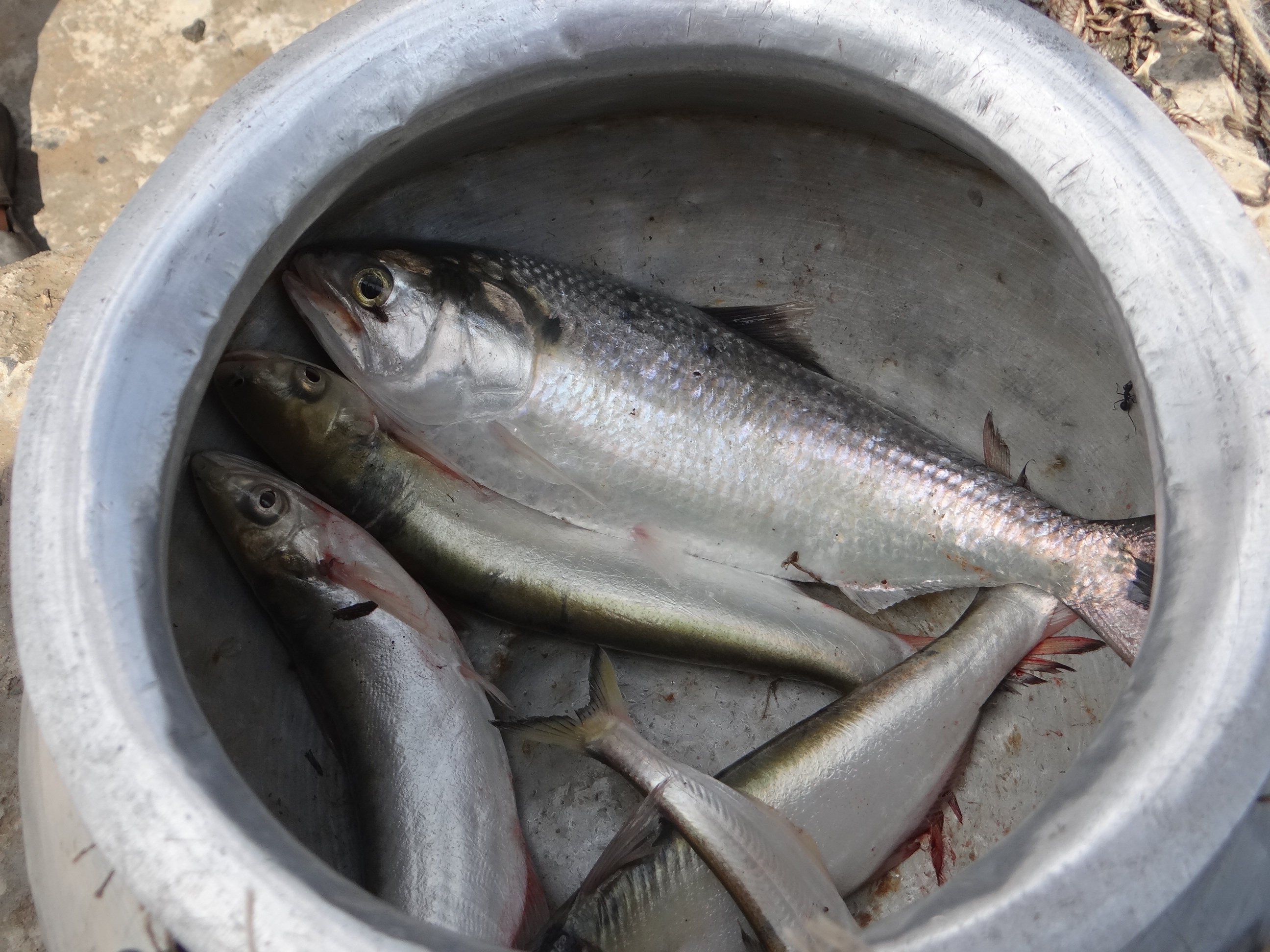
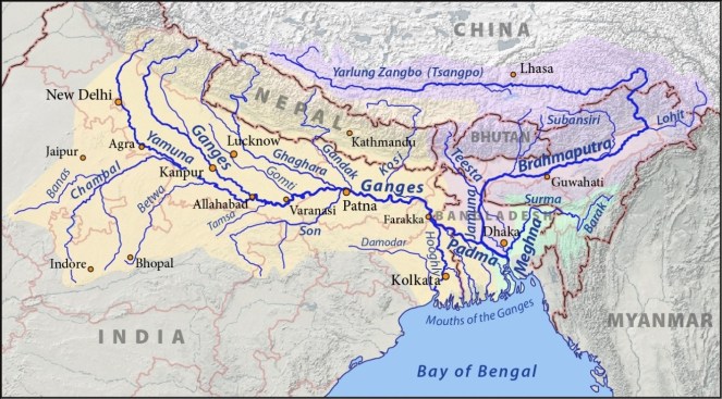
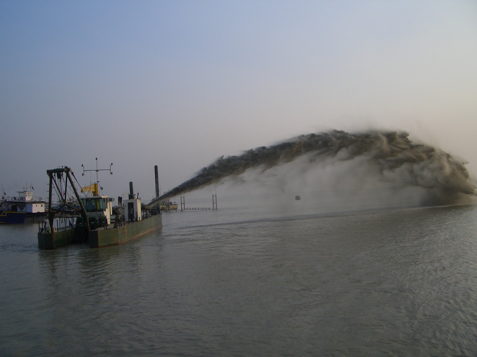
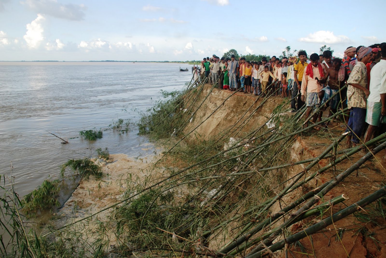
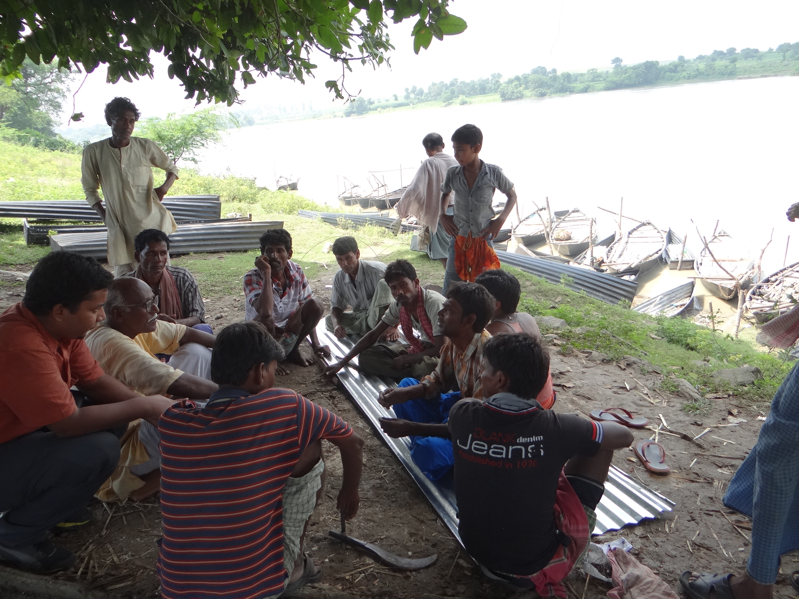
Farakka has profoundly changed the character, sediment regime and flow of Ganga. It is affecting lives of lakhs of people in India and Bangladesh through cycles of erosion, sedimentation, floods and affected fishing. Our response to the issue has been dismal. We have not conducted a single review of costs, benefits and impacts of Farakka Project so far. In addition to Farakka , Lower Ganga (Narora), Middle Ganga, Upper Ganga Barrages (Bhimgoda), Kanpur Barrage, Hydropower projects in Uttarakhand and other upstream states have affected the river in most profound ways. If we want to rejuvenate the Ganga, we need to institute a credible independent review the existing Barrages, not plan new ones. May be we can begin with a demand for such a review for Farakka on urgent basis. One World Rivers Day, let us wish for a long and healthy flow for the Ganga River, a symbol of all flowing rivers in India!

-Parineeta Dandekar (parineeta.dandekar@gmail.com)

POST SCRIPT on April 28, 2015:

An edited version of this article and photoessay on The Nowhere People — Environmental Refugees around Farakka, was published in the Mint on March 28th, 2015. Here it is in full: http://www.ficusmedia.com/traildiaries/2015/03/28/the-nowhere-people/
This article was made possible with a grant from The Third Pole and Asia Foundation.
Arati Kumar Rao

Dry Ganga downstream Upper Ganga, Bhimgouda Barrage in Haridwar Photo: Author