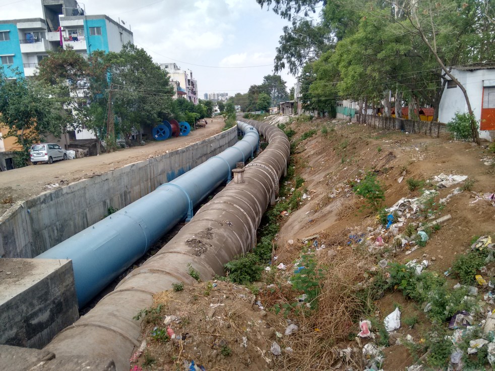
Above: Pipelines which supply water to Pune City from Khadakwasla Dam (Photo: Amruta Pradhan, SANDRP)
Urban narrative of Maharashtra revolves predominantly around cities of Mumbai (along with the Mumbai Metropolitan Region i.e. MMR), Pune, Nagpur and Nashik. Dominance of these large urban centres or the big cities over raw water sources is apparent. These cities have per capita water supply much more than the prescribed norms and continue to seek more water allocations. As Maharashtra gears up to fund more and more dams tapping finances from different sources, big cities with growing footprint of water consumption are all set to claim more water from these dams.Continue reading “Maharashtra Urban water sector in 2016: Big cities eyeing big dams”→
Above: Pandhapur wari, the yearly pilgrimage on Bhima banks (Source: pandharpurwari.com)
Bhima River, the largest tributary of Krishna River holds a special significance for the state of Maharashtra. The river is closely woven with the spiritual fabric of the state. The river is also referred to as Chandrabhaga River, especially at Pandharpur- the famous pilgrimage city, as it resembles the shape of the Moon. Bhima basin occupies nearly 70% area of the Krishna Basin falling in Maharashtra. Though the river originates in Maharashtra, it merges with Krishna river in Karnataka state, thus can be viewed as an independent basin.
In recent years Bhima basin has been subjected to excessive pressure of anthropogenic activities such as religious festivals attracting millions of pilgrims through the year, growing pollution by urban centres, growing sugarcane cultivation and over extraction of the river water to feed the water guzzling crop. These activities are taking toll in the river’s health and its water availability. Maharashtra state’s haste of building more and more dams in Krishna basin is most prominently visible in Bhima basin.
In this sense this sub-basin of Krishna River Basin, is its perfect miniature.
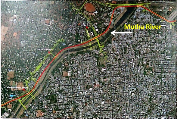
In a welcome move Western Zone Bench of National Green Tribunal (NGT) issued an interim stay on the proposed portion of the metro route passing through the Mutha river bed in the Pune city.[i] This directive was passed in an Environmental Interest Litigation (EIL) filed in the NGT on May 26 last year by a group of citizens contending that in the proposed metro rail alignment, a 1.7 km stretch passing through the left bank of the Mutha river could cause an irreversible damage to riverbank ecosystem along that route.
In the first phase two corridors of metro have been proposed in Pune. Corridor-I is of 16.59 km length from Pimpri-Chinchwad to Swargate and Corridor-II is of 14.6 km from Vanaz to Ramwadi. The petition before NGT Pune bench is against the 1.7 km stretch of Vanaz-Ramwadi corridor proposed through left bank of river Mutha. The metro route is proposed to enter the Mutha riverbed behind Savarkar memorial on Karve Road and proceed towards Pune Municipal Corporation (PMC) Bhavan and further to Food Corporation of India godowns behind Shivaji Nagar District Court.[ii] Two Metro stations are also proposed on the riverbed, one near Deccan Bus Stand and the other behind Sambhaji Park. Presently soil testing work for the project is in progress.
Proposed Metro alignment passing through Mutha riverbed (Source: Report of Technical Support Group on Biodiversity of PMC)
It certainly seems a good news for Pune’s rivers which have routinely made headlines for their pollution and poor state in general. Closer look towards the details however would cast a shadow on this development. The alignment through the river bed has been proposed despite PMC recently facing and losing a petition in NGT against 2.3 km long (and 24 m wide) road from Vitthalwadi to NH-4 bypass which was being constructed illegally right in the Mutha Riverbed. In its final judgment in July 2013 NGT ordered the road to be realigned. Subsequently a contempt petition was filed when PMC failed to comply with the orders where the NGT in January 2015 again ordered removal of the constructed road.[iii]Continue reading “NGT stays work of Pune Metro affecting rivers: Another violation of the river floodplain”→
Above: Narmada at Khalghat Photo: Parineeta Dandekar
“Ahalya, you will be an eternal dry river. Your path will be rocky and parched. You will receive water only when you meet the pious Godavari. That will be your only redemption”.
Ahalya by Raja Ravi Varma Source: Wikimedia Commons
Thus spoke Sage Gautam, pushing his wife Ahalya into a quagmire of dark desperation for ages. Ironically, it was Indra who, driven by lust, impersonated Sage Gautam and met Ahalya. In some versions of the story Gautam curses Ahalya into a stone slab, in some she becomes uncultivable, barren land. Till date, there exists a marriage custom in certain communities where the newly wed girl touches a dry stone by her feet.. it should remind her of her fate if she “strays” like Ahalya. But that is another story.
In the Western Ghats of Maharashtra where the Godavari rises, there is a tiny river called Ahalya meeting Godavari at the Trimbakeshwar Temple. If women and even Goddesses were made to suffer at the hands of patriarchy, how can rivers, the sacred feminine, be far behind?
Above: Menawali Ghat at Wai, Satara Dist (Photo: Sanket Deshpande)
The mighty Krishna River bears the name of Lord Krishna; the beloved dark and dusky lord worshipped throughout the country. Originating but a few kilometers from Arabian Sea, the river has chosen to flow towards Bay of Bengal becoming a lifeline of four states viz. Maharashtra, Karnataka, Telangana and Andhra Pradesh. In its journey of thousands of kilometers and thousands of years, the river witnesses an amazing diversity in language, lifestyle, food and culture.
Maharashtra is blessed to be an upper riparian state in the Krishna Basin. Sahyadri ranges of Western Ghats falling in Maharashtra are abode to early flows of Krishna River. In Maharashtra the river is perceived in a feminine form called ‘Krishna Mai’ meaning ‘Mother Krishna’. The River Krishna is one of the important rivers flowing through Maharashtra and has a tremendous religious and cultural significance. Agriculture and economy of districts like Satara, Sangli and Kolhapur thrive on Krishna mainstream.
Here we make an attempt to provide glimpse of Krishna River within Maharashtra. The article is based on Maharashtra specific river profiles that SANDRP has prepared for India Rivers Week 2016.Continue reading “Krishna River in Maharashtra: A Profile”→
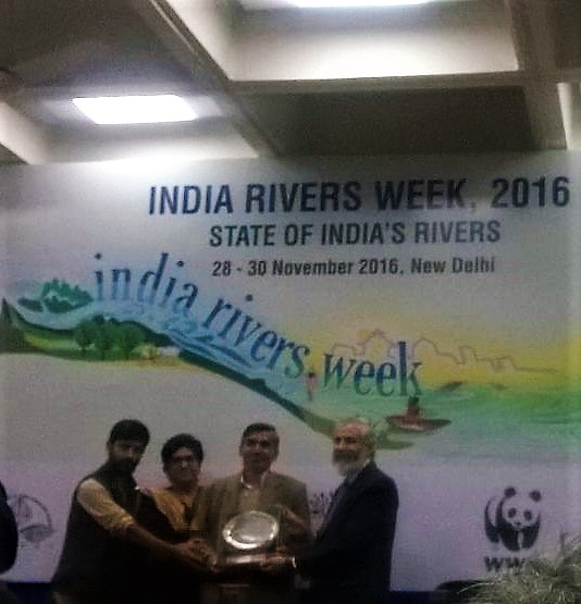
When I talk with Manshi, a friend and co-traveler from Himdhara Collective about Bhagirathh Prayas Samman that the collective received during the India Rivers Week 2016, she is modest, even slightly hesitant. She simply says, “We love the mountains, we want to protect them and help mountain communities fight the unequal battle against unplanned hydropower. That is one motivation of our work. But the other is recognition of the fact that we are privileged… privileged to be able to speak English, to work on a computer, to understand the bureaucratic procedures that alienate a tribal or forest dweller from her land. That understanding also drives us.”
Citation of Bhagirath Prayas Samman given to Himdhara Collective states: “Himdhara’s strength is its engagement with communities, movements and organisations. It has created an effective discourse around issues of resource distribution and their ownership and the resultant impacts on ecological spaces of mountain communities, especially vulnerable groups like indigenous people, dalits and women. It is an honor to recognize and celebrate Himdhara Environment Research and Action Collective’s extraordinary Bhagirath efforts in maintaining the integrity of rivers in Himachal Pradesh.”
In their own words, “Himdhara is an autnomous and informal non registered environment research and action collective, extending solidarity and support, in research and action, to people and organisations asserting their rights over their natural resources and agitating against corporatisation of these resources for destructive development in the state.”
Face of Hydropower in Kinnaur Photo: Himdhara
A collective of young, passionate and questioning minds, Himdhara has been working with communities in far flung areas of Himachal Pradesh include Lahaul and Spiti and Kinnaur in their fight against the onslaught of ill-planned and bumper to bumper hydropower projects in Himachal, amongst other issues.Continue reading “Bhagirath Prayas Samman: Himdhara Collective: Relentless Questioning and Doing”→
Yamuna Basin: River Yamuna[1] accounts for 7.10 % of the total geographical area of the country. TheHaryana state forms 6.5%[2]of the river basin. It drains an area of 366,223 square km in the Gangetic plain and constitutes 40.2% of Ganga Basin. The river annually carries 10,000 cubic billon meters (CBM) of water of with 4400 cbm is used for irrigation. Yamuna river basin forms the upper sub-basin of Ganga river[3] the total area of which is 35798.19 square km comprising of 47 water sheds.
Yamuna river originates from Bandar Punch glacier in Uttarkashi district of Uttarakand. The river flows through about 200 kilometers before reaching Haryana State at Shivalik Hills in Yamuna Nagar district. In the same district the river is trapped in Hathini Kund Barrage located in Kalesar National Park.
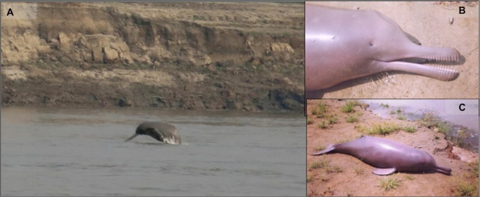
Above: (A) An image showing the Gangetic dolphin in its wild habitat (photo credit: Kadambari Deshpande), (B) a dead Gangetic dolphin calf (notice the pinhole like eyes), and (C) the calf is 1 m long, and adults measure to 2.6 m (photo credits for B & C: Sushant Dey).
Guest blog by Nachiket Kelkar
In 2015, The Times of India reported on the Ganges River Dolphin census exercise conducted in Uttar Pradesh, with the picture of a water buffalo to pass off as a dolphin. If you do not believe this, check out the image below[i]. Generally, most news reports on the river dolphin, some even by reputed news outlets (e.g. http://alert-conservation.org/issues-research-highlights/2016/5/30/rivers-of-destruction-the-implications-of-indias-national-waterways-bill-for-biodiversity), show the wrong species of dolphins, mostly marine species jumping acrobatically in aquariums. A forest department officer told us during their preparations for the Wildlife Week that, “if we put a beautiful dolphin’s picture, people will get more attracted to conserving the Gangetic dolphin, which is quite ugly, and the poor thing is also blind – toh achcha nahin lagta hai (it does not look good).” It does not stop here. A senior ecologist expressed concern recently in a public lecture, about the river dolphin becoming blind due to pollution. Against this background it is clear how little we know the Ganges Dolphin (our National Aquatic Animal, mind it) even today. Continue reading “Turning Blind Eyes: Do we care for river dolphins or their habitat?”→
Above Map of Cauvery basin from Indian Express, Sept 22, 2016
Higher demands than availability is the key problem in Cauvery basin. transparent, participatory, democratic, rule based management of demands over supply is the key need. Unfortunately, we do not have that. Greater misfortune is that the Cauvery Water Disputes Tribunal Award of Feb 2007, even as it is significantly flawed, is yet to be implemented since the Special Leave Petitions of Karnataka and Tamil Nadu, admitted in the Supreme Court, remain pending for over nine years now. The Supreme Court, in the meantime, (through its orders of Sept 5, 12 and 20) deals with the issue in a manner, that seems ad hoc in absence of clarity as to how all the relevant factors have been taken into account. Continue reading “Cauvery: Is there will for way forward? Will constitution of CMB help?”→
Like almost all urban areas, Pune’s seage management has been dismal. In a recent Public Interest Litigation (PIL) filed against Pune Municipal Corporation (PMC) in National Green Tribunal (NGT) for failing to control water pollution in Mula Mutha Rivers it was revealed that several crucial details regarding sewage generation and disposal in Pune city remain unknown even to PMC. PMC failed to furnish even the basic details like present and future generation of domestic sewage (from 2022- 2025), present handling capacity and performance of STPs for six months.[i]
Japan International Cooperation Agency (JICA) has recently agreed to extend a loan of 1000 Cr. to PMC under project ‘pollution abatement of River Mula-Mutha’.[ii] Utilizing this funding PMC has proposed to build 11 new sewage treatment plants (STPs) with treatment capacity of 396 MLD (Million Litres per Day). It is hard to imagine that PMC who celebrated the signing of the loan agreement in January 2016 was not in position to furnish even the basic details about sewage generation and treatment in May 2016.
Currently in Pune there are total ten STPs with installed capacity of 567 MLD. Five of them have been funded by PMC while the other five have been funded by JNNURM (Jawaharlal Nehru National Urban Renewal Mission) Phase I. Operation & Maintenance (O&M) of these plants has been outsourced by PMC to various contractors. Treated effluent is being discharged in the rivers Mula, Mutha Rivers. PMC recently admitted in the print media that though the installed capacity of its existing STPs was to treat 567 MLD, only 290 MLD was being treated at present.[iii] The balance – almost 50% of the sewage – is going into the river untreated. Pune’s Rivers are some of the most polluted in the country. Continue reading “My visits to Pune’s Sewage Treatment Plants: Citizens Not Allowed!”→