
Above: Menawali Ghat at Wai, Satara Dist (Photo: Sanket Deshpande)
The mighty Krishna River bears the name of Lord Krishna; the beloved dark and dusky lord worshipped throughout the country. Originating but a few kilometers from Arabian Sea, the river has chosen to flow towards Bay of Bengal becoming a lifeline of four states viz. Maharashtra, Karnataka, Telangana and Andhra Pradesh. In its journey of thousands of kilometers and thousands of years, the river witnesses an amazing diversity in language, lifestyle, food and culture.
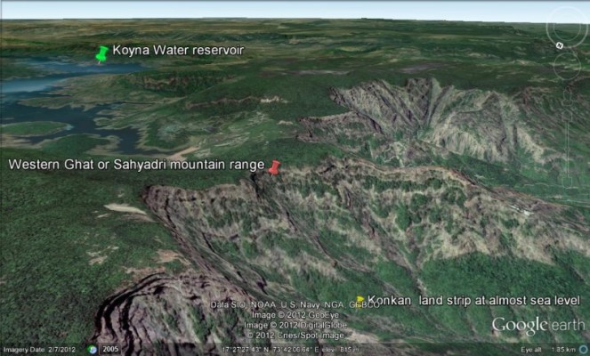
Maharashtra is blessed to be an upper riparian state in the Krishna Basin. Sahyadri ranges of Western Ghats falling in Maharashtra are abode to early flows of Krishna River. In Maharashtra the river is perceived in a feminine form called ‘Krishna Mai’ meaning ‘Mother Krishna’. The River Krishna is one of the important rivers flowing through Maharashtra and has a tremendous religious and cultural significance. Agriculture and economy of districts like Satara, Sangli and Kolhapur thrive on Krishna mainstream.
Here we make an attempt to provide glimpse of Krishna River within Maharashtra. The article is based on Maharashtra specific river profiles that SANDRP has prepared for India Rivers Week 2016.
Salient features of Krishna Basin
Krishna River is one of the important east flowing peninsular rivers. It is the fourth largest river of India after Ganga, Godavari and Brahmaputra. The river rises from the Western Ghats near Jor village of Satara district of Maharashtra at an altitude of 1337 m just north of Mahabaleshwar and after traversing a length of 1400 km empties into the Bay of Bengal at Hamasaladeevi (near Koduru) in Andhra Pradesh. Krishna Basin occupies an area of 2,58,948 sqkm which is nearly 8% of the total geographical area of the country. Largest part of the basin, nearly 44% lies in Karnataka. 26% of the basin falls in Maharashtra, about 15% in Telangana and another 15% in Andhra Pradesh.
The basin is roughly triangular in shape and is bounded by Balaghat range on the North, by the Eastern Ghats on East & the South and by the Western Ghats on the west. Clusters of hills running to the East of Sahyadris range of Western Ghats mark the South Western Boundary of The basin. Boundary between the Krishna & Cauvery Basins is marked by Devarayana Durga Forest- a small patch of 42.27km situated along the hill chains running across Eastern part of Tumkur District of Karnataka.[1] The interior of the basin is a plateau generally sloping eastwards.
Basin receives 85% of its annual rainfall during south-west monsoon. The rainfall, unevenly distributed varies temporally and spatially across the basin. Upper reaches of Krishna Basin lie in the 25 Km wide crest zone of Western Ghats which is the belt of heaviest rainfall region. Annual rainfall varies from 1000 to 3000 mm in this reach. River further enters in the region falling in the rain shadow area of the Western Ghat which receives less than 600 mm annual rainfall. Rainfall gradually increases to about 900 mm towards the East coast. The average annual rainfall in the basin is 1096.92 mm.

Principle tributaries of Krishna River
After originating the course of Krishna River in Maharashtra is generally south flowing. Tributaries like Koyna, Varna, Panchganga and Dodhganga flow eastward from slopes of Western Ghats to meet Krishna in Maharashtra State. The river takes an eastward turn after it enters Karnataka near Kurundwad after flowing a length of about 300 km. In Karnataka tributaries like Ghataprabha and Malaprabha meet Krishna River. Bhima which is the largest tributary of Krishna River flowing 861 kilometres through Maharashtra, Karnataka, and Telangana states, before confluence with the Krishna River at Kadlur (Raichur) in Karnataka. Near Kurnool in Andhra Pradesh the Krishna River is joined by another major tributary, Tungabhadra from the south, draining a major section of the Western Ghats in Karnataka. Smaller tributaries like Dindi, Musi, Palleru and Muneru draining the dry north-eastern parts of the basin join the river flowing through Telangana and Andhra Pradesh but do not add much water. Table below gives length of major tributaries-
| Length of River & its major tributaries (Source: Krishna Basin Profile by CWC) | ||
| Sr. No. | Tributary | Length (km) |
| 1 | Krishna | 1435.07 |
| 2 | Bhima | 860.67 |
| 3 | Tungabhadra | 551.56 |
| 4 | Musi | 352.02 |
| 5 | Malaprabha | 325.74 |
| 6 | Ghataprabha | 298.73 |
| 7 | Munneru | 217.79 |
| 8 | Varna | 158.43 |
| 9 | Koyna | 151 |
| 10 | Dudhganga | 129.78 |
| 11 | Panchganga | 128.68 |
Krishna Basin in Maharashtra
Out of total drainage area 251369 Sq km of Krishna basin 69425 Sq km area lies in Maharashtra. The catchment in Maharashtra predominantly consists of upper reaches of catchment of the Krishna mainstream (consisting of Upper Krishna Sub Basin and small portions of Middle Krishna & Ghataprabha Sub basins) and Bhima sub basin. For Maharashtra Bhima sub basin can very well be considered as an independent river basin since it is fairly large in size (largest of all the sub basins of Krishna River falling in Maharashtra) and also since Bhima River does not merge with Krishna within the state boundary of Maharashtra.
This article thus focuses on catchment of Krishna mainstream flowing through Maharashtra. Out of total length of 1400 km, 301 km of Krishna mainstream flows through Maharashtra which has length of 301 km and catchment of about 5766 sqkm spreading over three districts viz. Satara, Sangli and Kolhapur.[2] Given below is the map of Krishna Sub-Basin in Maharashtra.

Cultural and Spiritual Significance
In Maharashtra Krishna River is lined by throughout its length by ‘ghats’. Many temples were built on Ghats. Shortly after its origin Krishna river banks are beautified by Menawali ghat built on the river in 1780 during Peshwa rule.[3] Today the place is a popular location for shooting Bollywood films.[4] Sangli town which once was capital of Sangli a small princely state has similar ghats. Mythology tells that this region was once inhabited by Rama and Seeta during their exile. Maharashtra’s spiritual and mythological fabric is intimately woven with the early flows of Krishna and its tributaries like Koyna, Venna, Panchganga. Especially confluences of these tributaries with Krishna are marked by several small places of spiritual significance.
While general direction for Krishna’ flow in Maharashtra is southward, there is only once when the Krishna travels Northwards for a very short length. That is at Pasarni village near Wai. This area is commemorated with the name ‘Uttar Vahini’ (North flow).
Forests and Biodiversity of Krishna Basin
Krishna River during its course supports a large array of biodiversity. Especially the borders of the basin lined with Western & Eastern Ghats harbor various native species of plants, trees, birds and wild animals. Thick forested slopes of the Ghats are a home for Sahyadri Tiger Reserve. It is the first Tiger Reserve of Western Maharashtra and 4th Tiger Reserve of Maharashtra State spreading over two Protected Areas those of the Koyana Sanctuyary and Chandoli National Park of 741.22 sqkm and adjoining area in the landscape 424.34 sqkm, total of 1165.56 sqkm.[5] The area is spread over 4 districts namely, Satara, Sangli, Kolhapur and Ratnagiri. Sahyadri Tiger Reserve declared in January 2010 is home for wild fauna such as Tigers, Gaurs, Deer, Leopard cats, Panthers, Sloth bears, Barking deer, Mouse deer etc. Grassland of the basin in Solapur Dist. of Maharashtra is a home for Great Indian Bustard, the endangered bird species.

Dams & Barrages
Krishna basin in Maharashtra has undergone extensive dam development. Krishna mainstream flowing though Upper Krishna sub-basin in Maharashtra is the second highest dammed sub basin in entire Krishna catchment. The Upper Krishna sub basin has 188 dams, 4 barrages and 57 weirs. There are as many as 61 Lift Irrigation Schemes and 10 power houses! Dominance of the dams, LIS and power houses in the basin is clearly reflected in the table below which summarizes sub-basin wise water resource structures in Krishna Basin. While the major dams are deployed for producing hydro power, lift irrigation schemes have been feeding the growing sugar cane cultivation of the region. Some of these projects like Krishna Marathwada Irrigation Scheme (KMIS), Koyna Hydro Electric Power Station IV have been featured in irrigation scam unveiled in Maharashtra in 2012. KMIS saw a cost escalation of Rs. 2,462.55 Cr. while Koyana HE Power Station IV saw a cost escalation of Rs. 1,091.27 Cr.
| Table: Basin wise number and types of water resources structure (Source: Krishna Basin profile by CWC p.39) | |||||||
| Sr. No. | Sub-Basin | Dams | Barrages | Weirs | Anicuts | Lifts | Power House |
| 1 | Bhima Lower | 68 | 5 | 0 | 0 | 2 | 0 |
| 2 | Bhima Upper | 273 | 0 | 1 | 0 | 30 | 9 |
| 3 | Krishna Lower | 29 | 2 | 0 | 0 | 1 | 4 |
| 4 | Krishna Middle | 34 | 0 | 0 | 0 | 8 | 4 |
| 5 | Krishna Upper | 188 | 4 | 57 | 0 | 61 | 10 |
| 6 | Tungabhadra Lower | 37 | 0 | 0 | 3 | 4 | 3 |
| 7 | Tungabhadra Upper | 31 | 1 | 0 | 1 | 13 | 5 |
Following are some important dams in the basin
| Important dams in Upper Krishna Basin (Source: Krishna Basin Profile by Central Water Commission) | |||||
| Sr. No. | Name of dam | Name of the project | Location | Storage Capacity
(MCM) |
Year of Completion |
| 1 | Dhom Dam | Krishna Major Irrigation Project | Wai Satara Dist Maharashtra | 331.05 | 1977 |
| 2 | Ghataprabha Dam | Ghatprabha medium irrigation Project (Hydroelectric & Irrigation) | Kolhapur Dist
Maharashtra |
42.735 | 2009 |
| 3 | Koyna Dam | Koyna Irrigation Project (Hydroelectric, Irrigation) | Satara Dist
Maharashtra |
2836 | 1964 |
| 4 | Warna Dam | Warna Major Irrigation Project (Hydroelectric, Irrigation) | Kolhapur Dist | 779.348 | 2000 |
Growing claims on Krishna waters
Increasing footprint of sugarcane cultivation: Sugarcane has been one of the biggest consumers of water of Krishna Basin in Maharashtra. All the three districts falling in Krishna basin of Maharashtra viz. Satara, Sangli and Kolhapur are on the forefront of producing sugarcane. Kolhapur is the second highest sugarcane producer district in the State accounting for 14.98% of the States production. Together the three districts account for nearly 30% of the sugarcane production in the State (Sangli 8.51% & Satara 7.57%).[6]
Area under sugarcane in these districts has nearly doubled in last decade. Sugarcane in the basin is predominantly surface irrigated.[7] This water guzzeling crop which needs 45000 cum of water per hectare[8] was planted on more than 2.6 lakh ha in the three districts in 2012-13.[9] Table showing increase in the district wise area under sugarcane from 2005-05 to 2012-13 is annexed at the end.
Westward diversion of Krishna waters: Koyna dam built in Krishna basin has the highest live storage capacity among all of Maharashtra dams, at 2836 MCM (105 TMC), and it has five power houses with total capacity of 1956 MW. Out of this 1920 MW installed capacity comprising stage I to IV divert the water out of Krishna basin, into the west flowing water surplus basins. As per KWDT award of 2010, the Koyna dam annually diverts 1911.4 MCM of water from Krishna basin to west flowing rivers.[10] The diversion continued even in severe drought like situation in 2014-15 when the downstream dams like Nagarjunsagar or Srisailam were nearly at zero live storage.
Proposed Intra-Basin Transfers: In addition to dams and power houses, several intrastate links have been proposed by Gov of Maharashtra over Krishna Basin. Four out of the total seven links are proposed in Upper Krishna Basin. Following table summarizes these links and the status of their Detailed Project Report (DPR).
| Sr. No. | Name of the Intra-State Link | Rivers | Status of DPR |
| 1 | Upper Krishna – Bhima (System of six links) | Krishna-Bhima | Completed |
| 2 | Koyna – Nira | Koyna-Nira | Completed |
| 3 | Koyna – Mumbai City | Koyna | Completed |
| 4 | Kolhapur-Sangali-Sangola | Krishna & Bhima | Completed |
Approval to the first link has been recently given during a special cabinet meeting of Maharashtra government.[11] In the first phase, 7 TMC water would be diverted from Krishna to Bheema River through underground pipes. The cabin gave nod to outlay of Rs 4,817 crore for the first phase. Several experts including SANDRP and also the state officials from water resources department have objected to the diversion on the ground of high cost and low feasibility.
Ill effects of dams in Krishna Basin
Reservoir induced seismicity by Koyna Dam: The dam, with a capacity of 105 TMC, constructed in 1964 is considered to be the world’s best site to prove the correlation of dams and earthquakes.[12] In fact Koyna is said to be the unique example in world to study the reservoir-induced seismic activity. Seismologist emphasise that the reservoirs such as Koyna and Warna are responsible for the earthquakes in south Maharashtra region which has officially experienced more than 1.19 lakh quakes in five decades. Just last month on Nov 25, 2016 an earthquake measuring 4.3 on the Richter scale was recorded with its epicentre 10km north of the Koyna dam.[13] This was the fifth tremor of magnitude below 4.5 on Ritcher scale reported in seven months in the dam area.
Floods caused by backwater effect of Almatti dam: Maharashtra has been experiencing floods in Upper Krishna basin caused by the backwater effect of the Alamatti Dam built in Bijapur Dist of Karnataka.[14] In August 2005 after a heavy downpour, large quantities of water were released from Koyna dam raised the water levels of Almatti dam.[15] Satara, Sangli and Kolhapur along with some areas in Karnataka experienced devastating floods caused by backwater afflux of Almatti dam. The estimated loss was Rs.600 crores.[16] The issue was addressed with a joint inspection made by the two States.[17] Since then there has been an understanding between Maharashtra and Karnataka governments that Almatti dam levels should not go above 518 meters.[18]
The issue has surfaced again as Karnataka plans to raise the height of Almatti dam from 519m to 524m. Experts have been warning that it will only worsen the backwater effect of Almatti reservoir causing increase in the frequency of the floods in Satara, Sangli and Kolhapur. Dam breaks Analysis report, disaster management report and Emergency Action plans for the increased height of Alamatti dam have not addressed this issue.[19]
Another viewpoint in this regard has been that it is actually the Hippargi barrage , with FRL of 531.4 m from mean sea level and design flood of 20,000 cumecs built upstream of Almatti dam that has been responsible for causing the floods in Maharashtra. But no further information is available regarding this.
Deteriorating Water Quality of Krishna River
Krishna River along with its several tributaries features prominently in the Central Pollution Control Board’s report of 2014-15 which identifies polluted stretches of rivers and prioritizes them for restoration. Throughout its course urban centres seem to play a major role in polluting the river. Maximum number of stretches (12) is in Maharashtra. Of these 12 stretches 5 stretches with a total length 423 km are of Krishna and its tributaries.
According to a report by Planning Commission[20] Satara accounts for the largest share and releases about 32.5 per cent and 22.9 per cent of wastewater and solid waste, respectively, followed by Karad. The stretch of the river from Karad to Sangli is highly polluted due to release of effluents, mainly from sugar industries and distilleries. According to the report in Sangli, Miraj and Kupwad about 99 percent of the sewage generated by the Municipal Councils and over 50 per cent of sewage discharged by Municipal Corporation totaling up to 48.645 MLD goes untreated. Effluents discharged into the river from many of the industries in Kolhapur and Sangli have a very high BOD load. Absence of solid waste management which was a neglected cause of pollution has now been identified a ‘greater problem’.[21]
| Polluted stretches in Krishna Basin (Source: River Stretches for Restoration of Water Quality, CPCB, 2014-15) | |||||
| Sr. No. | River | Details of Stretch | Length
(km) |
BOD Range or Max value (mg/l) | Priority Class defined by CPCB |
| Maharashtra | |||||
| 1 | Krishna | Shindi to Kurundwad | 200 | 5.4-24.0 | II |
| 2 | Indrayani | Moshi to Alandi | 96 | 8.1-9.2 | I |
| 3 | Panchaganga | Shirol to Kolhapur | 40 | 4.6-7.6 | IV |
| 4 | Nira | Sangavi to Shindewadi | 80 | 8.1-14.6 | III |
| 5 | Koyna | Karad to Papdarde | 7 | 7.8 | IV |
Summing up
Increasing number of dams, growing sugarcane cultivation, urban and industrial water demand have altered the face of the basin. Water parched stretches of Krishna River downstream of the dams are further being polluted by untreated sewage, effluents from sugar distilleries and other industries.
Because of incessant dam building, the Upper Krishna sub basin is leaping towards its closure point, meaning nearly all the sediments and water from the basin is trapped by the dams.[22] There has been an overall 94% reduction in Krishna sediments reaching the delta.[23]
The carrying capacity of the river is being stretched too far.
Compiled from various sources
By, Amruta Pradhan, Parineeta Dandekar, SANDRP, amrutapradhan@gmail.com
| Annexure I: Sugarcane Production (Ha)
(Source: Integrated State Water Plan for Upper Krishna Sub-Basin) |
||||
| Year | Satara | Sangli | Kolhapur | Total |
| 2005-06 | 38900 | 36800 | 94500 | 170200 |
| 2006-07 | 53600 | 53400 | 106300 | 213300 |
| 2007-08 | 60800 | 64700 | 113900 | 239400 |
| 2008-09 | 50400 | 55400 | 102500 | 208300 |
| 2009-10 | 53800 | 63200 | 112700 | 229700 |
| 2010-11 | 74000 | 76300 | 139900 | 290200 |
| 2011-12 | 70600 | 70500 | 146100 | 287200 |
| 2012-13 | 59800 | 60700 | 142000 | 262500 |
References
Krishna Basin Profile by Central water Commission
END NOTES
[1] https://sites.google.com/site/devarayanadurgaforest/geography
[2]https://wrd.maharashtra.gov.in/portal/content/default/pdf/events/ISWPKrishna.pdf;jsessionid=pUq6FfmKxq6+9ijIpLrQnQ**
[3] https://sites.google.com/site/waipanchgani/places-near-to-wai/peshawe-wada-menavali
[4] http://timesofindia.indiatimes.com/home/sunday-times/The-promise-of-Wai/articleshow/1523289.cms
[5] http://www.kolhapurwildlife.org/sahyadri-tiger-reserve.html
[6] http://www.vsisugar.com/india/statistics/maharashtra_statistics.htm
[7] http://www.iwmi.cgiar.org/Publications/IWMI_Research_Reports/PDF/PUB111/RR111.pdf?galog=no
[8] http://www.indiawaterportal.org/sites/indiawaterportal.org/files/krishna_river_basin_assessment.pdf
[9]https://wrd.maharashtra.gov.in/portal/content/default/pdf/events/ISWPKrishna.pdf;jsessionid=pUq6FfmKxq6+9ijIpLrQnQ**
[10] https://sandrp.in/wp-content/uploads/2015/09/drp-july-aug-2015.pdf
[11] http://timesofindia.indiatimes.com/city/mumbai/Rs-4817-cr-plan-for-diverting-Krishna-water-to-Marathwada/articleshow/54680758.cms
[12]http://timesofindia.indiatimes.com/city/kolhapur/Koyna-earthquakes-triggered-by-reservoir-claim-seismologist/articleshow/50815347.cms
[13] http://timesofindia.indiatimes.com/city/kolhapur/Five-tremors-in-Koyna-area-in-seven-months/articleshow/55627572.cms
[14] http://www.thehindu.com/2005/09/04/stories/2005090404600400.htm
[15] http://www.frontline.in/static/html/fl2217/stories/20050826006413100.htm
[16]http://www.indiawaterportal.org/sites/indiawaterportal.org/files/Review%20needed%20on%20Krishna%20Water%20Tribunal%20Award%20on%20Alamatti%20Dam%20to%20save%20the%20Farmers_0.pdf
[17] http://www.thehindu.com/2005/09/04/stories/2005090404600400.htm
[18] http://timesofindia.indiatimes.com/city/kolhapur/Excess-water-flows-out-to-prevent-floods/articleshow/53535054.cms
[19]http://www.indiawaterportal.org/sites/indiawaterportal.org/files/Review%20needed%20on%20Krishna%20Water%20Tribunal%20Award%20on%20Alamatti%20Dam%20to%20save%20the%20Farmers_0.pdf
[20] http://planningcommission.nic.in/plans/stateplan/sdr_maha/ch-15-14-02-05.pdf
[21]http://indianexpress.com/article/cities/mumbai/maharashtra-to-tackle-water-pollution-new-policy-puts-spotlight-on-sewage-treatment/
[22] http://www.indiawaterportal.org/sites/indiawaterportal.org/files/krishna_river_basin_assessment.pdf
[23]https://sandrp.in/Shrinking_and_sinking_delta_major_role_of_Dams_May_2014.pdf

In the upstream of Almatti dam, Hipparagi barrage, with FRL/MWL at 531.4 m MSL and design flood of 20,000 cumecs, was constructed in Karnataka. (Refer http://india-wris.nrsc.gov.in/wrpinfo/index.php?title=Hipparagi_Barrage_B00592 ) Hipparagi barrage could be the reason (if at all) to aggravate the floods in Maharashtra state rather than Almatti dam water level even after raising to 524 m MSL from present 519 m MSL. The consultant appointed by KWDT2 tribunal at the cost of Karnataka, was pseudo consultant to bribe the tribunal jury and the various lawyers representing the riparian states. In the name of tribunals, lawyers and retired judges are striving to make money (legally and illegally) without trying to understand the river basin issues even after taking a decades time and fooling the people.
LikeLike
Many thanks, Sir. This is as usual very useful. We will make the necessary change. Plz provide more details of this episode, including name of the pseudo consultant, if possible. It would be great if you can write for us in more detail about this.
LikeLike
Excellent article.Krishna basin of Telangana is much bigger and needs correction.
LikeLike