Yamuna Basin: River Yamuna[1] accounts for 7.10 % of the total geographical area of the country. TheHaryana state forms 6.5%[2]of the river basin. It drains an area of 366,223 square km in the Gangetic plain and constitutes 40.2% of Ganga Basin. The river annually carries 10,000 cubic billon meters (CBM) of water of with 4400 cbm is used for irrigation. Yamuna river basin forms the upper sub-basin of Ganga river[3] the total area of which is 35798.19 square km comprising of 47 water sheds.
Yamuna river originates from Bandar Punch glacier in Uttarkashi district of Uttarakand. The river flows through about 200 kilometers before reaching Haryana State at Shivalik Hills in Yamuna Nagar district. In the same district the river is trapped in Hathini Kund Barrage located in Kalesar National Park.
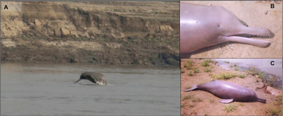
Above: (A) An image showing the Gangetic dolphin in its wild habitat (photo credit: Kadambari Deshpande), (B) a dead Gangetic dolphin calf (notice the pinhole like eyes), and (C) the calf is 1 m long, and adults measure to 2.6 m (photo credits for B & C: Sushant Dey).
Guest blog by Nachiket Kelkar
In 2015, The Times of India reported on the Ganges River Dolphin census exercise conducted in Uttar Pradesh, with the picture of a water buffalo to pass off as a dolphin. If you do not believe this, check out the image below[i]. Generally, most news reports on the river dolphin, some even by reputed news outlets (e.g. http://alert-conservation.org/issues-research-highlights/2016/5/30/rivers-of-destruction-the-implications-of-indias-national-waterways-bill-for-biodiversity), show the wrong species of dolphins, mostly marine species jumping acrobatically in aquariums. A forest department officer told us during their preparations for the Wildlife Week that, “if we put a beautiful dolphin’s picture, people will get more attracted to conserving the Gangetic dolphin, which is quite ugly, and the poor thing is also blind – toh achcha nahin lagta hai (it does not look good).” It does not stop here. A senior ecologist expressed concern recently in a public lecture, about the river dolphin becoming blind due to pollution. Against this background it is clear how little we know the Ganges Dolphin (our National Aquatic Animal, mind it) even today. Continue reading “Turning Blind Eyes: Do we care for river dolphins or their habitat?”→
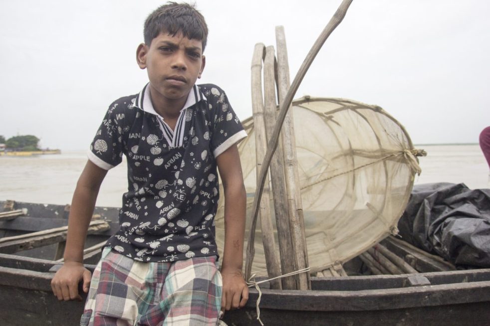
Above: Young kid from a fishing family in Kahalgaon, even the most informed communities (Ganga Mukti Andolan) are clueless about the government’s intentions (Photo by Veditum)
GUEST BLOG BY: Siddharth Agarwal
As the Ganga rises and fills streets and alleys with it’s water all along it’s course, I spend a time out at home, partially because of personal reasons and in some parts due to the rising levels of the river hindering all sorts of movement around it. Currently on a walk along the Ganga for Veditum India Foundation’s ‘Moving Upstream’ project, I’ve been able to walk a distance of about 1000 kms alongside it’s banks from Ganga Sagar till Varanasi in 50 days’ time. Some places saw me walking right next to the river while others had me maintaining my distance since it just wasn’t possible to peruse a course anywhere in the vicinity of the flooded banks.
The rising levels of the river are no surprise, an annual occurrence with variation only in ferocity. We’re surprisingly still caught off guard, every single year, with this news about floods in cities like Patna, Allahabad and Varanasi making it to national television on an almost daily basis. But what of all the places between Patna, Allahabad and Varanasi? What of all the places that are not cities and of all the people who are not urban dwellers? The major focus as I walk along the river are the people of the river and their lives, those who inhabit this space known to all as the vastly fertile Indo-Gangetic plains but unknown as a place extremely vulnerable to the forces of nature and shaky towards those man-made.
What will happen to a river that already has no fish and is way too salty. The barrages will mean doom for even the few fish that are left (Photo by Veditum)
I had been informed in advance of the situation of our fishermen by minds already working in the field of environment and rivers in our country, often mentioning that these communities were severely under-represented and very much neglected even when it came to discussions relating to them. Non-inclusiveness of communities while making decisions is not a new theme in India, but given the extent of impact that some upcoming government decisions/policies was going to have on these people, I decided to ask them a few questions as I proceeded upstream from Ganga Sagar, starting early June 2016.
Anywhere downstream of the Farakka barrage, the mention of the word barrage has a stunning effect on the people and 1975 is a year that fisher folks remember as a year of doom. For most readers and even for me before I started upon this trip, this would makes sense if one tries to put in a little effort in imagining how a barrage or dam might affect a river. But unlike how logic would dictate, this effect doesn’t exist just downstream of the barrage and similar reactions continued even further upstream, in Jharkhand and Bihar.
In places along the feeder canal from the Farakka Barrage, an increased frequency of ships to the Thermal Power Plants has resulted in rapid soil erosion (Photo by Veditum)
The National Mission for Clean Ganga and The National Waterways programme have been in the limelight for making grand promises of :
1.) Cleaning and maintenance of the river
2.) Economic Development and Cheaper Transportation.
Now, this is not a commentary on the efficiency and feasibility of making such proposals, simply an attempt to understand the impact of such programmes. EIA (Environmental Impact Assessment) and SIA (Social Impact Assessment) are the terms you might be looking for, something that ideally the governing authority should be taking care of. But why is any of this important or relevant to this article? It is because whatever happens in these places between Patna, Allahabad and Varanasi is very much relevant and important to discuss. These are not uninhabited spaces, but pretty well populated areas with a lot of lives at risk.
Coming back to the point of the two government programmes, firstly, the NMCG letting the Waterways programme run through protected areas and non-protected ecologically sensitive areas goes very much against the whole agenda why this mission was set up. Secondly, the waterways programme in a bid to decrease ‘transportation’ costs and utilise our river potential recently ran tests with large vessels on the Ganga.
Small country boats near Farakka. Wonder what large waves from huge vessels will do to these (Photo by Veditum)
What is surprising (or rather not) is that these test runs were without any warnings to fishermen and boatmen in said test sections, the few who were on the waters at the time of passing of these vessels had to face high waves, enough to topple a less experienced or unaware boatman. The news of these tests were flashed all over the main stream media, but failed to make it to those for whom it mattered. Not an uncommon occurrence at all, but till when will this go un-noticed? On asking these fishermen if they have any clue why this is happening, most of them responded in the negative while a few said they’ve learnt about the government’s plans to run large vessels on the river.
As this conversation extends and questions follow, it is gradually revealed that the picture is not clear and conversations have somehow trickled down in a very muzzled form. Though most fishermen laugh off the prospect of this being a constant activity because of the extreme reduction in water level that the river has seen these past years, often mentioning how large excavators and multiple tugboats have been needed anytime a large vessel has traversed these stretches in lean seasons. There’s talk of loss of fishing nets and reduced catch, difficulty in controlling small country boats in high waves, chances of accidents when transporting villagers to small ‘diars’ for agricultural work, loss of land where there’s no embankments and so on, but this also brings us to the most important part of this article.
The dark clouds often linger over the heads of those not involved, not informed (Photo by Veditum)
The Water Highway programme on the Ganga has been proposed on a 1500 km stretch from Allahabad to Haldia, with barrages at about every 100 kms. Now, an avid news reader would have knowledge of this as a great policy step but the fisherman who directly depends on the river for his livelihood does not. This holds true for maybe 15-20 different fishing communities that i’ve had the chance to interact with in the first 50 days and even the mention of new barrages was way too shocking for those who have had to bear the burden of Farakka’s impacts. There are even places where locals have signed their wishfulness of a barrage near their villages without understanding consequences and only having been shown the shiny side like we see everyday in the papers, called ‘development’.
The ‘Moving Upstream’ project intends to understand and present a narrative of the river and it’s people, hoping this will lead to more meaningful conversation and inclusive action by the government. In a recent announcement by Sushri Uma Bharti Ji – Union Cabinet Minister of Water Resources, River Development & Ganga Rejuvenation, she said she will march down the length of the river to take stock of the status of various projects commissioned by her. I’m glad that cues are possibly being taken from the Moving Upstream project, but like every other government project, when will our habit of assessment (if at all) after execution stop and preparedness & understanding before implementation materialise? I hope she does her Ganga yatra before approving any projects, I hope for inclusiveness.
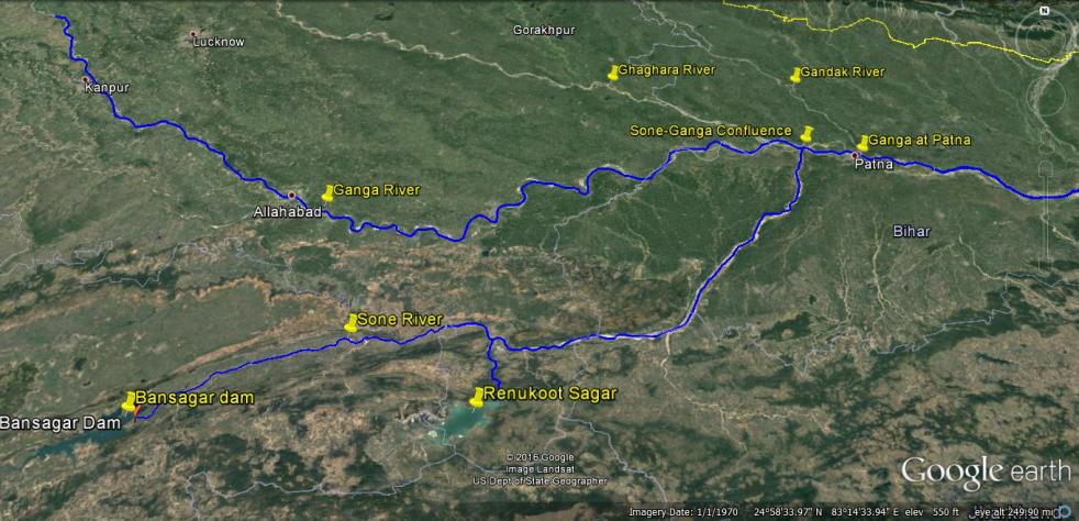
बाणसागर बाॅध, सोन नदी, गंगा नदी और पटना को दर्शाता मानचित्र
21 अगस्त 2016 की सुबह, गंगा नदी का जलस्तर लगातार बढ़ते हुए, पटना में 50.43 मीटर पर पहुॅच गया। जिससे पटना में गंगा नदी अपने पहले के उच्चतम बाढ़स्तर 50.27 मीटर से 16 सैंटीमीटर ऊपर बह रही थी। 22 अगस्त 2016 तक पानी का जलस्तर गंगा नदी के किनारे तीन अन्य स्थानों पर उच्चतम बाढ़स्तर को पार कर गया। जिसका विवरण निम्न हैः-
स्थान 22.08.2016 को उच्चतम बाढ़स्तर पुराना उच्चतम बाढ़स्तर बलिया उत्तरप्रदेश 60.30 मीटर 60.25 मीटर (14 सितंबर 2003) हाथीदाह, बिहार 43.17 मीटर 43.15 मीटर (07 अगस्त 1971) भागलपुर बिहार 34.55 मीटर 34.50 मीटर (05 सितंबर 2013)
इस तरह से हम देखते हैं कि पटना में उच्चतम बाढ़ का रिकार्ड तोडने के बाद, अब यह बाढ़ गंगा नदी के किनारे बसे बिहार और उत्तरप्रदेश के अन्य इलाकों में पहुॅच रही है। यहाॅ यह बात उल्लेखनीय है कि बिहार में अब तक वर्षा औसत से 14 प्रतिशत कम हुई है। सवाल यह उठता है कि इसके बावजूद गंगा में रिकार्ड तोडने वाली बाढ़ क्यों आयी?
Above: Map Showing the location of Bansagar Dam, Sone River, Ganga River and Patna
Water level of Ganga at Patna reached 50.43 m on Aug 21, 2016 morning with still showing rising trend. This level was already 16 cm higher than the highest ever recorded flood level (HFL) of Ganga at Patna of 50.27 m. By Aug 22, 2016, at three more sites along Ganga, the water level had already breached the highest recorded levels: Balia in Uttar Pradesh (Ganga Water level at 60.3 m, higher than the HFL of 60.25 m recorded on Sept 14, 2003), Hathidah in Bihar (Ganga water level at 43.17 m, higher than the HFL of 43.15 m recorded on Aug 7, 1971, that is 45 years back) and Bhagalpur in Bihar (Ganga water level at 34.55 m, higher than HFL of 34.5 m recorded on Sept 3, 2013). This means that the highest flood level that started at Patna is now travelling both upstream and downstream along Ganga.
Several districts of Bihar along Ganga are facing floods, with at least 10 lakh people affected and about 2 lakh people displaced. On Aug 21 alone, NDRF teams have rescued over 5300 people from Didarganj, Bakhtiyarpur, Danapur Chhapra, Vaishali and Maner. At least ten lakh people have been affected in Bihar, two lakh have been displaced and scores have been killed. It seems more like and annual natural calamity.
But that is not the case, if we look closely. Available information shows that the unprecedented floods that we are now seeing in Ganga in Bihar and UP are largely due to contribution of two dams: Bansagar Dam along Sone river in Madhya Pradesh in the upstream and Farakka Dam (misleadingly called a Barrage) on the Ganga river in West Bengal. If Bansagar Dam was operated in optimum way, than it need not have released over ten lakh cusecs of water. As pointed out by Bihar government, the high floods brought by Ganga in Patna are majorly due to the high flow contributed by Sone river upstream of Patna. Continue reading “A tale of two dams: Is Bihar’s unprecedented flood an avoidable man-made disaster?”→
Two years is not a lot of time. Yet it is good enough to know if the right path has been taken or not?
Prime Minister Modi during his campaign and immediately on taking charge of the new government in May, 2014 raised huge expectations with his proactive call to rejuvenate river Ganga. Seemingly like a personal mission, he put Ms Uma Bharti, a well known Ganga Bhakta in charge of the renamed Ministry of Water Resources, River Development & Ganga Rejuvenation (MoWR,RD&GR). Continue reading “WHY TWO YEARS OF GANGA REJUVENATION HAS BEEN LITTLE MORE THAN NOISE?”→
It was a pleasant November afternoon when we were travelling down the Ganga River by boat, surveying river dolphins. Tall grass had grown on both banks through the flood recession period. The water level had become very low already. Two magnificently large concrete buildings; one, the agricultural college, and the second, the industrial office, stood precariously by the edge of a rapidly eroding bank. At the turn of this bank, the Ganges Voyager appeared in a sudden sight. British tourists with gleaming shades, sunning their fair skins to balanced tan tempered by muslin umbrellas put over brick-red wooden tables, waved at us from the deck of the Voyager. Uniformed Indian attendants confirmed that they were not waving out to any dangerous people, in a re-enactment of the old colonial days. The Voyager had fifty air-conditioned luxury rooms. Their windows were made translucent by pale mauve and white chiffon curtains artistically tied in an hourglass shape. Continue reading “Four Boats at a River Crossing along Ganga”→
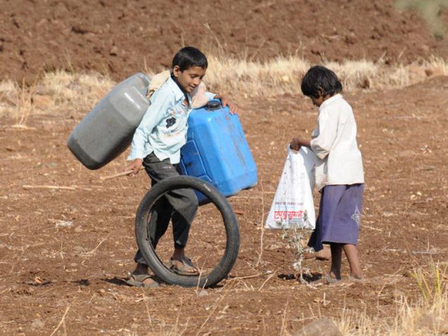
The State will now seek a Rs. 4,300-crore package for providing succour to over 16,000 drought-affected villages. Earlier State Relief and Rehabilitation Minister Eknath Khadse had declared over 14,708 villages drought-affected. He now said that the State’s assessment by October 31 showed that drought-like conditions also prevailed in 1,420 villages in Buldhana district in Vidarbha, and they would be added to the list of drought-affected villages.
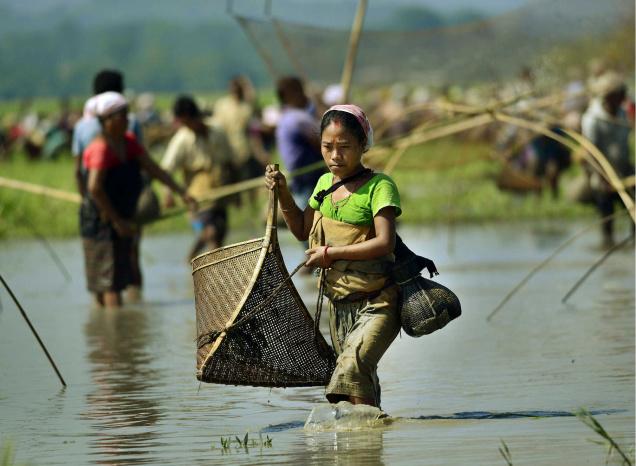
People of a village in Morigaon district of Assam fish in groups to celebrate ‘Kati Bihu’ on Sunday. The festival is closely related to agriculture, celebrated on the first day of the Kati month of the Assamese calendar. It is that time of the year when paddy grows in the fields and cultivators work hard for a good harvest.— Photo: Ritu Raj Konwar, The Hindu
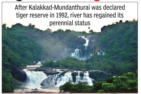
Tamirabarani teaches: Saving tiger is saving riverAfter Kalakkad-Mundanthurai was declared tiger reserve in 1992, Tamirabarani river has regained its perennial status. Though shorter than Cauvery and Vaigai, Tamirabarani has always held a special place in the state. It started turning dry for four months every year. People of Tirunelveli and Tuticorin thought their river too was going the way of other state rivers. But a move to save the tiger inadvertently became a save the-river policy. The Union ministry of environment and forests declared the Kalakkad – Mundanthurai area as a tiger reserve in 1992. In three years, there was a noticeable change. A study on water inflow into the Karayar river, a tributary, inside the reserve was taken up. Records show that from 1946 till 1990, the river received only 13,000 cubic feet of water annually. After the area was declared as a tiger reserve, the inflow increased to 23,000 cubic feet.