It’s a bit intriguing situation. IMD and Skymet experts are downgrading the monsoon rainfall from earlier forecast 100% to 92%. Both agencies are predicting even lower rainfall in remaining part of current South West Monsoon. Bihar has received 413.2 mm rainfall till Aug 2, 2018, 22% below normal. And yet, starting Aug 1, CWC’s flood forecasting sites along the Ganga were showing ominous portents. For the first time this monsoon, the sites started showing steep upwards trend. Continue reading “Will sluggish Farakka again create prolonged floods along Ganga in Bihar?”
Category: Floods

Overview of CWC Flood Forecasting Sites 2018: North India
Flood forecasting is an important activity during monsoon, considering the huge and increasing flood prone area, flood frequency, extent and flood damages. Accurate and timely flood forecasting can hugely help reduce the damages due to floods. Central Water Commission (CWC) is the only agency responsible for flood forecasting in India. To understand the CWC’s flood forecasting better, we have compiled the list of the various flood, inflow forecasting sites and flood monitoring sites in India.
In this compilation, we have given state wise list of CWC’s flood forecasting, flood monitoring and inflow forecasting sites, along with available details like rivers, sub basin, river basin, Warning level, Danger Level, High Flood Level, Full Reservoir Level, Maximum Water Level. As we see below, there are many gaps in this basic information for the sites that are part of CWC’s list.
Continue reading “Overview of CWC Flood Forecasting Sites 2018: North India”
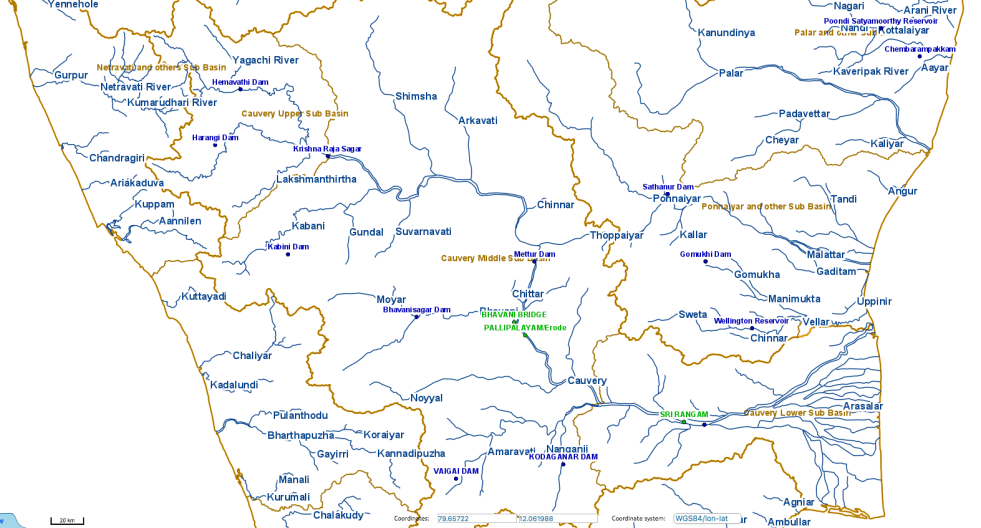
Cauvery is facing very serious flood risk, but CWC is in slumber
(The figure above is screen shot of CWC Flood forecasting site showing no warning signs even at 5 pm on 230718)
Almost all the big dams in Cauvery Basin are full on the earlier ever monsoon date this year. This includes Krishnaraj Sagar, Mettur, Kabini, Harangi, Hemavathi and Bhavanisagar. They are almost full and have started releasing large flows to the downstream areas. This is when we are past just about six weeks of South West Monsoon, the North East monsoon would come after that. It means that the basin is facing major risk of floods in next 2-5 months. And yet Central Water Commission, India’s flood forecasting agency, seems to be in deep slumber. It has not even bothered to update the flood readings on its designated sites from the 2017 figures. Continue reading “Cauvery is facing very serious flood risk, but CWC is in slumber”

Floods in Tripura, Mizoram, Barak Valley in June 2018
The second wave of floods (first wave came in around May 20-24) this year inA North East India is affecting Tripura, Mizoram and mainly Barak Valley in Assam. Worryingly, while CWC flood forecast site shows water level reaching unprecedented levels in Manu river at Kailashahar in North Tripura District, CWC seems to have NO flood forecasting site in Mizoram. At Matizuri site in Hailakandi district in Barak Valley in Assam, the Katakhal river also approaching its highest ever flood level. In Bangladesh too sites like Amalshid have crossed the HFL. Continue reading “Floods in Tripura, Mizoram, Barak Valley in June 2018”
CWC’s Weekly Reservoir Bulletin: Closer look warns of impending disaster
One of the key source of information about India’s water availability that the government provides and media and everyone else quotes is Central Water Commission’s weekly (updated every Thursday) “Reservoir Storage Bulletin”[i]. The Reservoir Storage Bulletin (RSB) currently tells about water storage position of 91 storage dams across India with total live storage capacity of 161.993 BCM (Billion Cubic Meters), spread over 18 states and 12 river basins. CWC uploads it with a disclaimer: “The Data contained in this Bulletin is as received from the State Government/Project Authorities.” Continue reading “CWC’s Weekly Reservoir Bulletin: Closer look warns of impending disaster”
US Dams, Rivers and People in 2017: There is so much to learn!
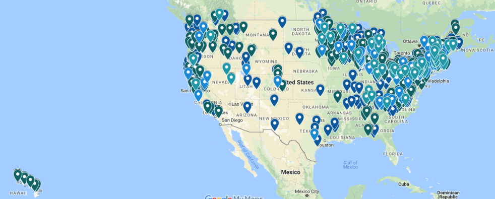
DECOMMISSIONING OF DAMS
Map of dams removed since 1916 Dams cause considerable harm to rivers. Dams have depleted fisheries, degraded river ecosystems, and altered recreational opportunities on nearly all of our rivers. Today, many dams that were once at the epicenter of a community’s livelihood are now old, unsafe or no longer serving their intended purposes. Learn how USA is working to remove dams and restore the rivers. (Map above is from Ameerican Rivers website, depicting the location of decommissioned dams in USA.) https://www.americanrivers.org/threats-solutions/restoring-damaged-rivers/dam-removal-map/ Continue reading “US Dams, Rivers and People in 2017: There is so much to learn!”
DRP: 16 Oct 2017: New Groundwater Guidelines threat to India’s Water Lifeline
GROUND WATER
New Draft Guidelines designed to privatise & destroy Groundwater The Ministry of Water Resources of the Union Government has on Oct 11, 2017 (see notice: http://www.wrmin.nic.in/forms/List.aspx?lid=1180&Id=6) put up draft guidelines on Groundwater management in India (see draft Guidelines: http://www.wrmin.nic.in/writereaddata/guideline-NOC-CGWA.pdf), with comment period of 60 days. The comments are to be sent to: Member Secretary, Central Ground Water Authority, West Block-2, Wing 3 (Ground Floor), Sector 1, RK Puram, New Delhi – 110066, e-mail: cgwa@nic.in.
New Draft Groundwater guidelines designed to destroy groundwater further and open floodgates for privatisation of common property resource? “Groundwater is a common property resource and should be used for greater good. But these guidelines are not doing that. Groundwater governance and management should happen in a transparent, participatory and accountable way but that too is not happening through guidelines,” Thakkar said.
Explaining, Thakkar said that the guidelines are “trying to make a system wherein state or district level authorities will be giving NOCs but whether those authorities have capacity to give NOCs after understanding the implications is the question.” “The draft guidelines also take out the need to recharge groundwater. Present regulations say that you if you take out groundwater you need to put in recharge capacity but now they are saying that’s not necessary and are only seeking charges. These things will definitely lead to further destruction of groundwater,” he added. http://www.livemint.com/Politics/irx1jFCWMFjGJk82Z8VZ2O/Govt-proposes-new-guidelines-on-groundwater-usage-by-industr.html, http://www.newindianexpress.com/nation/2017/oct/13/centre-proposes-water-conservation-fee-for-use-of-groundwater-1673480.html, http://www.newindianexpress.com/nation/2017/oct/14/townships-with-gym-club-must-pay-water-fee-1673790.html, http://www.hindustantimes.com/environment/centre-proposes-nixing-recharge-requirement-for-industries-extracting-groundwater/story-kN3iPmO9m4MIoYkUX32n7I.html
Continue reading “DRP: 16 Oct 2017: New Groundwater Guidelines threat to India’s Water Lifeline”
Ganga basin faces unprecedented floods in Aug 2017
Ganga Basin, particularly Bihar is facing unprecedented floods, starting on Aug 12, 2017. Water levels of Major tributaries of Ganga, including Kosi, Mahananda, Rapti, Ghagra, Bagmati, Gandak and Kamlabalan are close to or above the historically highest flood levels almost simultaneously. This has rarely happened in the past. The water level of Ghagra is close to HFL at Elgine Bridge in Barabanki district in Uttar Pradesh. Most other flood forecasting sites in North Bihar and East UP were shown as pink dots on CWC flood forecasting map on Aug 13-15, signifying that water level at these sites was above the danger level. This is possibly the beginning, this wave is expected to rise as it travels down towards Bihar and then W Bengal and Bangladesh. Continue reading “Ganga basin faces unprecedented floods in Aug 2017”

DRP: 14 August 2017 East & North East India face flooded Independence day
FLOODS 2017
SANDRP BLOG: Brahmaputra basin to face unprecedented floods starting Aug 12, 2017: https://sandrp.wordpress.com/2017/08/12/brahmaputra-basin-faces-unprecedented-flood-wave-in-aug-2017/
North Bengal Flood situation “Cooch Behar, North Dinajpur, Alipurduar, Jalpaiguri and Darjeeling are the five districts which have been affected by the flood. Earlier in the day, Irrigation Minister Rajib Banerjee said that the state government is tackling the flood in north Bengal on war footing.” 58,000 people had been affected in Alipurduar, Jalpaiguri and Cooch Behar districts.
MAY BE IF THEY WOKE TWO DAYS EARLIER WHEN NASA MAP CLEARLY SHOWED THE HEAVY RAINFALL HAVING ALREADY OCCURRED, THEY MAY NOT HAVE HAD TO TACKLE IT ON WAR FOOTING AND A LOT OF DAMAGE COULD HAVE BEEN AVOIDED? http://www.ndtv.com/india-news/flood-situation-worsening-in-north-bengal-says-mamata-banerjee-1736993
Continue reading “DRP: 14 August 2017 East & North East India face flooded Independence day”Brahmaputra basin faces unprecedented flood wave in Aug 2017
In the morning of Aug 11, 2017, while checking my daily morning routine sites, I saw the sudden appearance of purple patch (signifying rainfall in access of 175 mm rainfall in previous 24 hours) on NASA daily rainfall accumulation map for Indian subcontinent.[i] The purpose patch covered parts of the West Bengal, North East Indian and Bangladesh. I was taken aback, but it was not very unusual to see in the peak of monsoon. So as we usually do, I took a screenshot and put up on SANDRP FB page with a warning that this could lead to floods. I did not realize that this was the beginning of an unprecedented wave of floods for these regions that may extend to Ganga basin as I write this. Such purple patches generally disappear in 24 hours, since the rains do not last to long. However, in the case of current phase, not only the purple patch has last now for 42 hours, it has extended to the west, all along India Nepal region along the southern boundary of Nepal. Continue reading “Brahmaputra basin faces unprecedented flood wave in Aug 2017”
