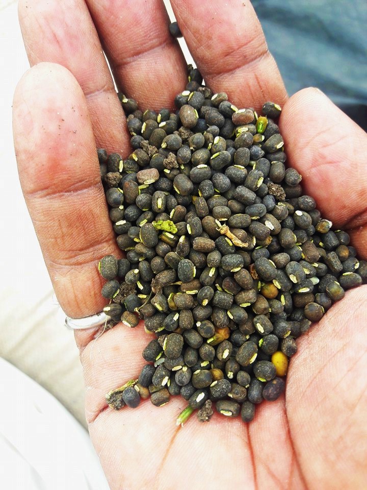
“I have harvested Moong (green gram) from my farm, now I’m harvesting Udad (black gram). Their price is crashing each day…I may not get even the Minimum Support Price (MSP)…But I’m not supposed to care about the price… its solely the farmer’s responsibility to reduce inflation and make India a superpower.”
…says Ashok Bhau, a dry land farmer dependent on rainfall and groundwater in the heart of Marathwada: Osmanabad.
Last year his Moong failed completely, there was no seed development and although his Tur (Pegion Pea/Arhar) fetched a very good price, it did not mean anything for the family as the productivity was dismally low following three droughts and dry wells[i]. Like many farmers in Marathwada, he burned his sugarcane on 4 acres after watering it for many months… finally there was no water to sustain it. We had written about soaring pulses last year.Continue reading “This is the time to protect Pulse Farmers in Marathwada”→
Like almost all urban areas, Pune’s seage management has been dismal. In a recent Public Interest Litigation (PIL) filed against Pune Municipal Corporation (PMC) in National Green Tribunal (NGT) for failing to control water pollution in Mula Mutha Rivers it was revealed that several crucial details regarding sewage generation and disposal in Pune city remain unknown even to PMC. PMC failed to furnish even the basic details like present and future generation of domestic sewage (from 2022- 2025), present handling capacity and performance of STPs for six months.[i]
Japan International Cooperation Agency (JICA) has recently agreed to extend a loan of 1000 Cr. to PMC under project ‘pollution abatement of River Mula-Mutha’.[ii] Utilizing this funding PMC has proposed to build 11 new sewage treatment plants (STPs) with treatment capacity of 396 MLD (Million Litres per Day). It is hard to imagine that PMC who celebrated the signing of the loan agreement in January 2016 was not in position to furnish even the basic details about sewage generation and treatment in May 2016.
Currently in Pune there are total ten STPs with installed capacity of 567 MLD. Five of them have been funded by PMC while the other five have been funded by JNNURM (Jawaharlal Nehru National Urban Renewal Mission) Phase I. Operation & Maintenance (O&M) of these plants has been outsourced by PMC to various contractors. Treated effluent is being discharged in the rivers Mula, Mutha Rivers. PMC recently admitted in the print media that though the installed capacity of its existing STPs was to treat 567 MLD, only 290 MLD was being treated at present.[iii] The balance – almost 50% of the sewage – is going into the river untreated. Pune’s Rivers are some of the most polluted in the country. Continue reading “My visits to Pune’s Sewage Treatment Plants: Citizens Not Allowed!”→
Above: Children trying to understand why their River Mutha is so polluted Photo: Parineeta Dandekar
Treating even 50% of its sewage is a dream that has been eluding Pune for decades. Mula, Mutha, Pavna and Indrayani Rivers crisscrossing Pune have routinely made headlines for pouring Pune’s sewage into Ujani Dam in the downstream, which supplies drinking water to several towns and villages, including the city of Solapur. All these rivers are classified as one of the 35 most polluted river stretches of India by Central Pollution Control Board (CPCB).[1]
Japan International Cooperation Agency (JICA) has recently agreed to extend a loan of 1000 Cr. under project ‘pollution abatement of River Mula-Mutha’.[2] Utilizing this funding PMC has proposed to build 11 new sewage treatment plants (STPs) with treatment capacity of 396 MLD. It is one of the star projects under Smart City programme and engineers of water supply department are gearing up for the construction of new STPs. As stated in the PMC newsletter of Feb 2016, the 11 new STPs will increase treatment capacity of Pune from current 477 MLD (Million Liters a Day) to 873 MLD which, it is claimed, will be sufficient to cater to sewage generation till year 2027.[3]Continue reading “Pune plans more STPs while existing plants under perform and there is no attempt to fix them”→
The dam induced flood disaster could only increase since we refuse to learn any lessons:
SANDRP Blog A tale of two dams: Is Bihar’s unprecedented flood an avoidable man-made disaster?Is the unprecedented water levels of Ganga that has flooded Bihar and UP an avoidable flood disaster? What role did the water releases from Bansagar dam in the upstream and Farakka Dam in the downstream play in this? SANDRP analysis of this developing situation. Feed back is welcome, Please help us disseminate this.Kindlyd also see the Hindi version of this blog here दो बाॅधों की कहानीः क्या बिहार की अप्रत्याशित बाढ़ एक टाली जा सकने वाली मानव जनित त्रासदी है?PRABHAT KHABAR newspaper of Ranchi carries “in-depth” articles by Parineeta Dandekar and Himanshu Thakkar of SANDRP in the context of Bihar floods and demand to decommission Farakka barrage. Flood expert Dinesh Misra explaining role of dams behind unprecedented Ganga flood. In Part I of a separate report he narrates about Bihar/ Patna floods due to Ganga and Sone. Also see, बिना नदियों के उफान के ही पटना डूब गयाBBC Hindi website has published this based on a radio discussion they carried earlier on the issue of Bihar floods and role of Bansagar and Farakka dam.
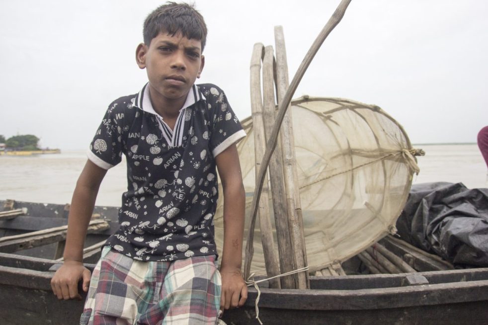
Above: Young kid from a fishing family in Kahalgaon, even the most informed communities (Ganga Mukti Andolan) are clueless about the government’s intentions (Photo by Veditum)
GUEST BLOG BY: Siddharth Agarwal
As the Ganga rises and fills streets and alleys with it’s water all along it’s course, I spend a time out at home, partially because of personal reasons and in some parts due to the rising levels of the river hindering all sorts of movement around it. Currently on a walk along the Ganga for Veditum India Foundation’s ‘Moving Upstream’ project, I’ve been able to walk a distance of about 1000 kms alongside it’s banks from Ganga Sagar till Varanasi in 50 days’ time. Some places saw me walking right next to the river while others had me maintaining my distance since it just wasn’t possible to peruse a course anywhere in the vicinity of the flooded banks.
The rising levels of the river are no surprise, an annual occurrence with variation only in ferocity. We’re surprisingly still caught off guard, every single year, with this news about floods in cities like Patna, Allahabad and Varanasi making it to national television on an almost daily basis. But what of all the places between Patna, Allahabad and Varanasi? What of all the places that are not cities and of all the people who are not urban dwellers? The major focus as I walk along the river are the people of the river and their lives, those who inhabit this space known to all as the vastly fertile Indo-Gangetic plains but unknown as a place extremely vulnerable to the forces of nature and shaky towards those man-made.
What will happen to a river that already has no fish and is way too salty. The barrages will mean doom for even the few fish that are left (Photo by Veditum)
I had been informed in advance of the situation of our fishermen by minds already working in the field of environment and rivers in our country, often mentioning that these communities were severely under-represented and very much neglected even when it came to discussions relating to them. Non-inclusiveness of communities while making decisions is not a new theme in India, but given the extent of impact that some upcoming government decisions/policies was going to have on these people, I decided to ask them a few questions as I proceeded upstream from Ganga Sagar, starting early June 2016.
Anywhere downstream of the Farakka barrage, the mention of the word barrage has a stunning effect on the people and 1975 is a year that fisher folks remember as a year of doom. For most readers and even for me before I started upon this trip, this would makes sense if one tries to put in a little effort in imagining how a barrage or dam might affect a river. But unlike how logic would dictate, this effect doesn’t exist just downstream of the barrage and similar reactions continued even further upstream, in Jharkhand and Bihar.
In places along the feeder canal from the Farakka Barrage, an increased frequency of ships to the Thermal Power Plants has resulted in rapid soil erosion (Photo by Veditum)
The National Mission for Clean Ganga and The National Waterways programme have been in the limelight for making grand promises of :
1.) Cleaning and maintenance of the river
2.) Economic Development and Cheaper Transportation.
Now, this is not a commentary on the efficiency and feasibility of making such proposals, simply an attempt to understand the impact of such programmes. EIA (Environmental Impact Assessment) and SIA (Social Impact Assessment) are the terms you might be looking for, something that ideally the governing authority should be taking care of. But why is any of this important or relevant to this article? It is because whatever happens in these places between Patna, Allahabad and Varanasi is very much relevant and important to discuss. These are not uninhabited spaces, but pretty well populated areas with a lot of lives at risk.
Coming back to the point of the two government programmes, firstly, the NMCG letting the Waterways programme run through protected areas and non-protected ecologically sensitive areas goes very much against the whole agenda why this mission was set up. Secondly, the waterways programme in a bid to decrease ‘transportation’ costs and utilise our river potential recently ran tests with large vessels on the Ganga.
Small country boats near Farakka. Wonder what large waves from huge vessels will do to these (Photo by Veditum)
What is surprising (or rather not) is that these test runs were without any warnings to fishermen and boatmen in said test sections, the few who were on the waters at the time of passing of these vessels had to face high waves, enough to topple a less experienced or unaware boatman. The news of these tests were flashed all over the main stream media, but failed to make it to those for whom it mattered. Not an uncommon occurrence at all, but till when will this go un-noticed? On asking these fishermen if they have any clue why this is happening, most of them responded in the negative while a few said they’ve learnt about the government’s plans to run large vessels on the river.
As this conversation extends and questions follow, it is gradually revealed that the picture is not clear and conversations have somehow trickled down in a very muzzled form. Though most fishermen laugh off the prospect of this being a constant activity because of the extreme reduction in water level that the river has seen these past years, often mentioning how large excavators and multiple tugboats have been needed anytime a large vessel has traversed these stretches in lean seasons. There’s talk of loss of fishing nets and reduced catch, difficulty in controlling small country boats in high waves, chances of accidents when transporting villagers to small ‘diars’ for agricultural work, loss of land where there’s no embankments and so on, but this also brings us to the most important part of this article.
The dark clouds often linger over the heads of those not involved, not informed (Photo by Veditum)
The Water Highway programme on the Ganga has been proposed on a 1500 km stretch from Allahabad to Haldia, with barrages at about every 100 kms. Now, an avid news reader would have knowledge of this as a great policy step but the fisherman who directly depends on the river for his livelihood does not. This holds true for maybe 15-20 different fishing communities that i’ve had the chance to interact with in the first 50 days and even the mention of new barrages was way too shocking for those who have had to bear the burden of Farakka’s impacts. There are even places where locals have signed their wishfulness of a barrage near their villages without understanding consequences and only having been shown the shiny side like we see everyday in the papers, called ‘development’.
The ‘Moving Upstream’ project intends to understand and present a narrative of the river and it’s people, hoping this will lead to more meaningful conversation and inclusive action by the government. In a recent announcement by Sushri Uma Bharti Ji – Union Cabinet Minister of Water Resources, River Development & Ganga Rejuvenation, she said she will march down the length of the river to take stock of the status of various projects commissioned by her. I’m glad that cues are possibly being taken from the Moving Upstream project, but like every other government project, when will our habit of assessment (if at all) after execution stop and preparedness & understanding before implementation materialise? I hope she does her Ganga yatra before approving any projects, I hope for inclusiveness.
काल दि. २३ ऑगस्ट २०१६ रोजी महाराष्ट्र-तेलंगण आंतरराज्य मंडळाच्या आज झालेल्या पहिल्याच बैठकीत तुमडीहेटी, मेडिगट्टा आणि चनाखा-कोर्टा बॅरेज या तीन बॅरेजचे काम सुरू करण्यासाठी दोन्ही राज्यांदरम्यान करार करण्यात आले. कमालीची गोपनीयता पाळत केल्या गेलेल्या या कराराबद्दलची अत्यंत मोघम टिप्पणी प्रसार माध्यमांना पाठविण्यात आली. तुमडीहेटी, मेडिगट्टा आणि चनाखा-कोर्टा बॅरेजमुळे महाराष्ट्र राज्यातील यवतमाळ, चंद्रपूर आणि गडचिरोली जिल्ह्यातील 30 हजार हेक्टर जमीन सिंचनाखाली येणार असून उपसा सिंचन योजनांना बारमाही शाश्वत पाण्याचा स्त्रोत उपलब्ध होणार आहे असे या टिप्पणीत नमूद केले आहे. तसेच या प्रकल्पामुळे महाराष्ट्रातील एकही गाव, गावठाण बुडणार नाही, नदीकाठच्या गावांना पुराचा धोका नाही व हे प्रकल्प दोन्ही राज्यासाठी फायदेशीर ठरणारे असून उपसा सिंचन योजनांना बाराही महिने पाणी मिळणार आहे असा दावा करत या भागातील नागरीकांनी या प्रकल्पांना विरोध करु नये असे आवाहनही महाराष्ट्राच्या मुख्यमंत्र्यांनी त्यांनी केले. Continue reading “महाराष्ट्र-तेलंगण आंतरराज्यीय करार: जनतेच्या मुलभूत हक्कांचे व देशाच्या पर्यावरणीय कायद्यांचे उल्लंघन”→
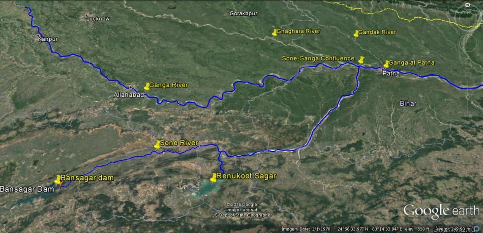
बाणसागर बाॅध, सोन नदी, गंगा नदी और पटना को दर्शाता मानचित्र
21 अगस्त 2016 की सुबह, गंगा नदी का जलस्तर लगातार बढ़ते हुए, पटना में 50.43 मीटर पर पहुॅच गया। जिससे पटना में गंगा नदी अपने पहले के उच्चतम बाढ़स्तर 50.27 मीटर से 16 सैंटीमीटर ऊपर बह रही थी। 22 अगस्त 2016 तक पानी का जलस्तर गंगा नदी के किनारे तीन अन्य स्थानों पर उच्चतम बाढ़स्तर को पार कर गया। जिसका विवरण निम्न हैः-
स्थान 22.08.2016 को उच्चतम बाढ़स्तर पुराना उच्चतम बाढ़स्तर बलिया उत्तरप्रदेश 60.30 मीटर 60.25 मीटर (14 सितंबर 2003) हाथीदाह, बिहार 43.17 मीटर 43.15 मीटर (07 अगस्त 1971) भागलपुर बिहार 34.55 मीटर 34.50 मीटर (05 सितंबर 2013)
इस तरह से हम देखते हैं कि पटना में उच्चतम बाढ़ का रिकार्ड तोडने के बाद, अब यह बाढ़ गंगा नदी के किनारे बसे बिहार और उत्तरप्रदेश के अन्य इलाकों में पहुॅच रही है। यहाॅ यह बात उल्लेखनीय है कि बिहार में अब तक वर्षा औसत से 14 प्रतिशत कम हुई है। सवाल यह उठता है कि इसके बावजूद गंगा में रिकार्ड तोडने वाली बाढ़ क्यों आयी?
Above: Map Showing the location of Bansagar Dam, Sone River, Ganga River and Patna
Water level of Ganga at Patna reached 50.43 m on Aug 21, 2016 morning with still showing rising trend. This level was already 16 cm higher than the highest ever recorded flood level (HFL) of Ganga at Patna of 50.27 m. By Aug 22, 2016, at three more sites along Ganga, the water level had already breached the highest recorded levels: Balia in Uttar Pradesh (Ganga Water level at 60.3 m, higher than the HFL of 60.25 m recorded on Sept 14, 2003), Hathidah in Bihar (Ganga water level at 43.17 m, higher than the HFL of 43.15 m recorded on Aug 7, 1971, that is 45 years back) and Bhagalpur in Bihar (Ganga water level at 34.55 m, higher than HFL of 34.5 m recorded on Sept 3, 2013). This means that the highest flood level that started at Patna is now travelling both upstream and downstream along Ganga.
Several districts of Bihar along Ganga are facing floods, with at least 10 lakh people affected and about 2 lakh people displaced. On Aug 21 alone, NDRF teams have rescued over 5300 people from Didarganj, Bakhtiyarpur, Danapur Chhapra, Vaishali and Maner. At least ten lakh people have been affected in Bihar, two lakh have been displaced and scores have been killed. It seems more like and annual natural calamity.
But that is not the case, if we look closely. Available information shows that the unprecedented floods that we are now seeing in Ganga in Bihar and UP are largely due to contribution of two dams: Bansagar Dam along Sone river in Madhya Pradesh in the upstream and Farakka Dam (misleadingly called a Barrage) on the Ganga river in West Bengal. If Bansagar Dam was operated in optimum way, than it need not have released over ten lakh cusecs of water. As pointed out by Bihar government, the high floods brought by Ganga in Patna are majorly due to the high flow contributed by Sone river upstream of Patna. Continue reading “A tale of two dams: Is Bihar’s unprecedented flood an avoidable man-made disaster?”→
Maharashtra & Telangana governments, it has been announced, will be signing a pact for three irrigation projects to be constructed on River Godavari. Under the agreement, the two states would take up Tummidihatti, Medigadda (Kaleswaram) and Chanaka–Korata projects. Chief Minister of Telangana K Chandrasekhar Rao has reportedly said that “this would herald a new era in the relations between the two states and would be a standing example of how the states can resolve inter-state disputes without the Centre’s intervention.”[i]
This pact which has been looked at as ‘historical victory’ for Telangana for convincing the neighbouring states is in fact one of the most blatant and outright violations of India’s environmental laws. Tummidihetti Project & Medigadda Project featured in the agreement have long history of gross irregularities and violations exposed by several apex agencies as well as media. SANDRP has visited these project sites multiple times, studied and written extensively about the projects and also repeatedly sent submissions to Chief Minister of Maharashtra pointing out the violations. The agreement is also being signed, keeping the affected people and also people in the Godavari river basin in two states completely in the dark. Some of the links for these articles are given at the end of this article. Continue reading “Proposed Maharashtra Telangana Inter-state Water sharing Agreement of Aug 23, 2016: In complete violation of people’s rights & environmental laws of India”→
Op-EdNGT failed its mandate by allowing AOL eventThis is such an amazing editorial on the issue of destruction of floodplain by Art of Living, whose behaviour is brazen, but predictable, it says! So amazingly forthright, it says “ Far more unfortunate, however, is the manner in which the NGT appears to have conducted itself in this affair. It is a sad commentary on the state of environmental governance n the country that its premier green body”, NGT, “ has to prevaricate on its earlier order”. It concludes. NGT failed to protect such an ecologically sensitive area. It is deeply disturbing that the country’s apex environmental tribunal allowed itself to be pressured and intimidated. Salutes to the Author of this forthright editorial! Meanwhile, the committee of experts, appointed by Green has found that the “entire floodplain area used for the main event site” has been “completely destroyed” causing “invisible loss of biodiversity” that “may never be able to return”. In its 45 page report, submitted to the NGT on July 28, the seven-member panel, said “the entire floodplain area used for the main event site, i.e. between the DND flyover and Barapullah drain (on the right bank of river Yamuna) has been completely destroyed, completely destroyed not simply destroyed. The ground is now totally levelled, compacted and hardened, totally devoid of water bodies or depressions, and almost completely devoid of any vegetation (except a few large cattails at the base of of the DND flyover)”. On the contrary AOL alleged that NGT appointed committee is biased, unscientific and lacks credibility.
 Continue reading “This is the time to protect Pulse Farmers in Marathwada”