
International media has been full of stories this last few weeks, about the likely fate of the world’s biggest dam project: The Three Gorges Dam of China. The stories ranged from possible imminent threat of collapse of the dam to those from China that rubbished all such ideas. Part of it was fuelled by the World’s anti China mood due to the Covid and its expansionist activities including at Indian borders. But part of the reason was the difficulty to getting hard facts, since China does not have free media or democracy and suppresses any critical information. One direct evidence of this Chinese tendency was apparent when Reuters was the first one to publish on July 22, 2020, the story of a dam collapse in China on June 7, full 45 days after the event and even that story could not find any official to quote about the dam collapse. A more telling example of China’s tendency to suppress basic facts would be difficult to come by from recent times.
Trying to separate wheat at chaff from these reports (see below we have quite a few from credible international media), we see that even by China’s own admission, the TGD may be safe for now. At the same time, there is no doubt that even as the vast Yangtze River downstream from the TG Dam was flooded, the dam continued to release huge 33000 cumecs (11.65 lakh cusecs) of water. Thus the dam that was supposed to help protects from the floods have in fact ended up adding to floods to the flooded downstream river. Secondly, it is also clear that China had to blast embankments or levees in at least two provinces (Jiangxi and Anhui provinces) so that the downstream Wuhan city (now infamous for the birth of Covid-19), among others could be saved from literally deeper water trouble. Three Gorges Dam’s credibility has also taken a huge beating in the process. And the monsoon is not yet over, though observers are hopeful that the worst this year may have gone past. More pertinently, we still do not know how many of the 94 000 (or is it 98 000 or 104 000) big dams have breached in these floods. On balance, China surely comes out with much diminished credibility.
CHINA
Three Gorges may be safe for now, but at what cost? At 8:20 a.m. of July 20, in preparation for an upcoming flood peak, the Three Gorges Dam opened seven spillways to release water, despite the fact that water levels downstream are already at emergency levels. Chinese authorities also started to break dikes in Jiangxi and Anhui provinces to divert the downstream floods, otherwise, Wuhan would become an “ocean city” and its 11 million residents will be stuck in deep water. https://www.theepochtimes.com/two-chinese-provinces-sacrificed-to-save-wuhan-and-three-gorges-dam_3438135.html (26 July 2020)
Concerns grow as China braces for more heavy rains and floods Three Gorges Dam: Reservoir water level at Three Gorges Dam on Yangtze River has risen by 12 metres in past 10 days and is nearing its design maximum of 175 m. It’s now at 160 m (525 ft).
– On Friday, large parts of Enshi – a Hubei city home to about 400,000 people – were flooded due to heavy rains and an overflowing Qingjiang River that runs through it. Such was the extent of the deluge that city officials upgraded their emergency response level three times – eventually to the highest possible – in less than five hours. https://www.scmp.com/news/china/society/article/3093766/concerns-grow-china-braces-more-heavy-rains-and-floods (18 July 2020)
Xinhua under fire for playful flood report To create an eye-catching effect, Xinhua has used in its July 22, 2020 report its WeChat account to “personify the floods,” describing the deluges as “naughty kids who want to go outside and play.” This was a reference to the breached levees and the massive pressure on the Three Gorges Dam, which straddles the river upstream in the Hubei Province. The Chinese netizen criticized the mainstream media for adopting such a light-hearted tone to cover natural calamities, showing no sympathy for victims and their suffering. https://www.taiwannews.com.tw/en/news/3973065 (July 25, 2020)
Commentary China struggles with ‘once-in-a-century’ floods that may be new normal While providing a good overview and newer developments like sponge cities, Prof. Asit Biswas predictably also harps on Dams.
“The most dangerous period of the flooding may be ahead. Past experiences indicate major floods are most severe in late July and up to mid-August, as heavy rains subside after the South China monsoon season is over.
The latest flood has almost reached the scale of the historic flood in the middle and downstream reaches of Yangtze river in 1998 which lasted from mid-June to early September. The 1998 flood impacted over 180 million people and damaged 13 million homes.
Over the years, China has also invested significant work into assessing risks by identifying developments in flood-prone areas, their vulnerabilities and possible ways to reduce flood risk to build resilience.
These include sponge cities programmes, the rehabilitation of natural wetlands and construction of artificial wetlands in new cities and rain gardens in old and new cities.
In recent years, these infrastructures have been complemented with green solutions such as the sponge city programme, artificial wetlands, rain gardens, and permeable pavements.
China’s sponge cities programme now covers 30 cities, including Shanghai, Wuhan and Xiamen. By the end of 2020, these cities are expected to be able to absorb at least 70 per cent of rainwater.
They use porous surfaces and plan for large spaces to contain rainwater. These include permeable roads and sidewalks, green roofs, wetlands and natural vegetation to absorb, store and drain rainwater.
These cities have essentially made flood risk management a central pillar of their urban planning.
Additionally, with floods increasing in frequency and intensity, sponge cities also require all new and large construction projects – such as buildings and factories – to have storage areas for rainwater to temporarily hold flood waters.” https://www.channelnewsasia.com/news/commentary/china-south-floods-2020-hubei-jiangxi-yangtze-12946780 (21 July 2020)
Highest water level ever at Three Gorges so farAccording to the Three Gorges Corp, the water level in the reservoir reached a record high flood season level of 164.18 meters on July 19. The previous high level reached during the flood season since the dam became fully operational in 2012 was 163.11 meters. The reservoir is designed to hold a maximum water level of 175 meters. https://scitechdaily.com/excessive-rainfall-in-china-three-gorges-dam-and-other-yangtze-river-dams-spill-water/ (July 25, 2020)
https://foreignpolicy.com/slideshow/july-24-2020-best-photos-of-week-portland-protests-asia-flooding-wildfires-sperm-whale/ (24 July 2020)
Worst Flooding in Decades Raises Concerns Over Three Gorges WSJ says its worst flooding in six decades in China. Last week, several days of fresh rain brought the water level at the dam, located several hundred miles upstream from Wuhan in central Hubei province, to its highest point since construction was completed in 2009. The latest round of flooding forced eastern Anhui province to open up two dikes and blast another two to release waters, inundating some 45,000 acres of arable land. The province on Saturday raised its flood alert to the highest level. Song Lianchun, director of China’s National Climate Center, told reporters last week that the number of days of heavy rain in China has been rising by roughly 4% each decade over the past six decades. https://www.wsj.com/articles/worst-flooding-in-decades-raises-concerns-over-chinas-three-gorges-dam-11595337875 (21 July 2020)
Deformation at Three Gorges within limits China on Saturday (July 18) reported that the vaunted Three Gorges Dam experienced “displacement, seepage, and deformation” as it was hit with the “No. 2 Flood” of the year but that these were within “the normal range.” On July 21 Chinese state-run voicebox the Global Times cited engineers as saying that the “elastic deformation is recoverable and not permanent, and that of the Three Gorges Dam has always been within the design limits.” In another article on July 22, the Global Times cited Wang Hao, an academician of the Chinese Academy of Engineering, as claiming that the “concrete materials used by the dam are different from ordinary concrete” and that it will continue to cure and strengthen until it reaches its “peak strength in 100 years.” https://www.taiwannews.com.tw/en/news/3972343 (23 July 2020)
China Defends Three Gorges, rubbishes all speculationAs of Tuesday, the dam had intercepted 10.7 billion cubic meters of floodwater with a maximum peak clipping ratio (the ratio by which flood is intercepted) of 46.7 percent in the latest round of floods, the Three Gorges Corp (CTG), operator of the mega project, told the Global Times.
– “China’s largest recorded flood in the past 2,500 years was in 1870 with a peak flow of 105,000 cubic meters per second. The Three Gorges Dam is designed to withstand more, even a peak flow of 124,300 cubic meters per second,” said Wang. Wang also introduced that there is still 21.1 billion m3 of flood control capacity on stand-by in the Three Gorges Reservoir, and risks in the Yangtze River basin are under control.
– According to the academician, 101 reservoirs along the Yangtze River, including the Three Gorges Reservoir, are engaged in a joint operation to curb the flooding. He said that there are 1,400 flood reporting stations in the Three Gorges area, covering 580,000 square kilometers of the upstream basin. Hydrological and meteorological data can be rapidly collected. The forecast can reach seven days in advance, and the accuracy of a 24-hour forecast reaches 98 percent. https://www.globaltimes.cn/content/1195357.shtml (22 July 2020)
Risk to old dams in China The dam can hold back waters to a level of 175 meters above sea level; according to the Bureau of Hydrology of the Chanjiang (Yangtze) Water Resources Commission, the latest (Friday) height at the dam was 158.85 meters, down from 164 meters on Tuesday. Yet more rain is predicted, and if smaller, older dams upriver from Three Gorges overflow or fail, then the pressure on the main dam could quickly overwhelm either its capacity or even its structural integrity. https://www.nationalreview.com/corner/the-risks-of-chinas-three-gorges-dams-flooding/ (July 25, 2020)
Dam collapse could point to a ‘black swan’ disaster This report reveals now, on July 22, 2020 that an earthen dam at Shazixi in Yangshuo county in China’s Guanxi region overflowed and collapsed on June 7, no one died, but it brought unprecedented floods in the downstream area. Completed in 1965, the dam, made of compacted earth, was designed to hold 0.195 million cubic metres of water, and meet the irrigation needs of Shazixi’s farmers. On a visit to the reservoir in mid-July, Reuters found the length of the dam, of about 100 metres, had largely vanished. It was reinforced 25 years ago. The report describes the event as black swan event for China’s aging 94 000 dams.
– In 2006, the Ministry of Water Resources said, between 1954 and 2005, dykes had collapsed at 3,486 reservoirs due to sub-standard quality and poor management. It was unclear if record-breaking rains were to blame for the Shazixi collapse or if the dam’s emergency spillway had been blocked by silt or if it was a design problem. No one from any of the official agency was available to respond.
– According to a notice at the Shazixi reservoir’s monitoring station, the 151.2 metre-tall dam was built with a once-every-two-century worst-case scenario in mind in which water was expected to reach 149.48 metres. Last month, it overflowed. In the county seat of Yangshuo in June, more rain fell in three hours than usually falls in two months. https://www.reuters.com/article/us-china-weather-floods-dams/dam-collapse-in-china-could-point-to-a-black-swan-disaster-idUSKCN24N047 (22 July 2020)
On 20 July 2020 a very large landslide occurred in the Enshi Tujia and Miao Autonomous Prefecture in Hubei Province, China, blocking the Quinjiang River. The Xinhua report for this event indicates a volume of about 10 million cubic metres. The main valley was blocked and a barrier lake developed, although it has now breached safely. https://blogs.agu.org/landslideblog/2020/07/22/quinjiang-river-landslide-1/ (22 July 2020)
HYDRO POWER PROJECTS
Tamil Nadu Residents fear Sillahalla HEP will lead to loss of farmlands, impact wildlife This mega dam scheme in the Nilgiris will be considered for TORs in the upcoming EAC Meeting on the 29th July 2020:
“Farmers and local residents who live along the course of the Sillahalla stream, which originates in Udhagamandalam town, and flows through the major agricultural belts of the Nilgiris, have begun organising themselves to protest against the mammoth project, which has an estimated cost of ₹4,952 crore.
Sivalingam, who is leading the opposition to the project, said that the Sillahalla Social and Cultural Protection Committee estimates that more than 10,000 people live along the course of the Sillahalla stream will be either directly or indirectly affected by the project.
“The stream is already extremely polluted due to the water from more than 10 carrot-cleaning machines, as well as sewage from Udhagamandalam town and a number of villages being let into the stream,” said Mr. Sivalingam. “The entire drainage and grey water of the Ooty municipality, neighbouring villages and institutions like public schools, resorts and encroachments outside the town flow into the stream which is to be dammed. Ooty already attracts about 3 lakh visitors every year. This is likely to increase to 5 lakh in the next five years. The waste water generated by this huge floating population has already created serious pollution problems. If the water in the Sillahalla stream is dammed and left stagnant for the most part of the year it is bound to become a major health hazard,” said Mr. Sivalingam, adding that the Sillahalla watershed has also been prone to numerous landslips from 1978 onwards, and numerous villages surrounding the stream have been declared to be prone to landslips by the district administration.
Venugopal Dharmalingam, honorary director of the Nilgiri Documentation Centre, has also voiced his opposition to the project, stating that the project will destroy the Kundah region. “The projects were proposed in 2007 but were not taken up because of their doubtful technical feasibility…while the projects are now being pushed through without the mandatory environmental assessment and public hearings, which is illegal,” he said.
“The Tamil Nadu government had taken a decision long back that no more hydroelectric dams will be built in the Nilgiris. In 1995, the late Chief Minister, Jayalaithaa cancelled plans for the construction of a hydroelectric dam near Kotagiri because of its harmful side effects. She stated in a press release that ‘no projects or schemes should be undertaken at the cost of and detrimental to the existing ecosystem.’ It is a tragedy that the present government which is sworn to implement the late CM’s dreams is destroying the very place she dearly loved,” he said” https://www.thehindu.com/news/national/tamil-nadu/residents-fear-sillahalla-hydro-electric-project-will-lead-to-loss-of-farmlands-impact-wildlife/article31970473.ece (02 July 2020)
Uttarakhand Official report critical of Pancheshwar DamThe recently-released State of Environment Report compiled by the Uttarakhand Pollution Control Board in collaboration with GB Pant Agriculture and Technical University has said that the proposed Pancheshwar Dam along the Indo-Nepal border will put more than 300 species of flora and fauna in danger. The report points out that the dam will have an adverse impact on around 43 mammals and 193 varieties of flora along with 30 species of fish and 70 species of birds found in the region. https://timesofindia.indiatimes.com/city/dehradun/proposed-pancheshwar-dam-along-indo-nepal-border-will-put-flora-fauna-at-risk-report/articleshow/77186334.cms (27 July 2020)
Industry New Solar power cheaper than existing Hydro A storage-based solar project proposed to make Leh, the union territory’s nerve centre, self-reliant in power has been hanging fire over the administration’s insistence on quota of free power. Central renewable energy agency SECI had in March submitted the proposal to build a 50 MW (mega watt) solar power plant with 60 MW battery storage in March. The project is estimated to cost Rs 400 crore and guarantees at least 16 hours of green power at Rs 6 per unit, which is 25-30% cheaper than power supplied to Leh by NHPC from the existing Nimo Bozgo Hydropower project. https://energy.economictimes.indiatimes.com/news/renewable/solar-storage-plan-to-power-leh-hangs-fire/77177678 (26 July 2020)
Jammu & Kashmir Human cost of Baglihar HEP
The Baglihar dam in Jammu and Kashmir bears testimony to the enormous human costs associated with hydroelectricity projects. https://www.thethirdpole.net/hi/2020/07/24/video-the-human-cost-of-the-baglihar-dam/ (July 24, 2020)
Himachal Pradesh Himalayan hydropower is not a green alternative Interesting account and some amazing photos about Himachal Hydro projects in particular and Himalayan hydro projects in general. https://www.thethirdpole.net/2020/07/22/opinion-himalayan-hydropower-is-not-a-green-alternative/ (22 July 2020)
DAMS
MoEF Agenda for the 1st meeting of newly constituted EAC for River Valley Projects, to be held on July 29, 2020, the agenda made public only on July 22, a week before the meeting, along with the constitution of the EAC for RVP. There is very big question mark over the constitution of the new EAC, since nothing is known about the environmental credentials of the newly constituted EAC chairman or members, nor about their track record of taking independent (of Govt) stand on difficult issues. We request the readers to share any information they can about any of the members of the new EAC. The MoEF has not made anything public as to how the chairman and members of the EAC were selected. From the list of members given with the agenda, it seems the Ministry could not find any woman from India worthy of being member of this EAC, the gender balance in the choice by the ministry says a lot.
- Brahmagavhan Lift Irrigation Scheme (10, 000 CCA) in Aurangabad District of Maharashtra FOR: ToR
- Rammam Hydro Power Project-III (3 x 40 MW) in dis Darjeeling Tehsil Darjeeling Pulbazar W Bengal by NTPC: ToR.
- Rongnichu HEP (115 MW) in Tehsil- Gangtok, Dist- East Sikkim, Madhya Bharat Power Corp Ltd: EC
- Expansion of Sirkari Bhyol Rupsiabagar HEP (120 MW) in Pithoragarh Dist, Uttarakhand, UJVNL: Amendment of ToR
- Vishnugad Pipalkoti Hydro-Electric Project (444 MW) in Chamoli dist, Uttarakhand by THDC: ToR
- Sela Urthing HEP (202 MW), Near Village Sela Pithorgarh, Dist, Uttarakhand by UJVNL: ToR
- Sillahalla Pumped Storage Hydroelectric Project-I (4×250 MW), in dist Nilgiris, Tamil Nadu by TN Generation & Distribution Corp: ToR (http://environmentclearance.nic.in/writereaddata/Form-1A/Agenda/22072020ZPAVRUKP1stEACAgenda.pdf)
Uttar Pradesh Govt releases 25 crore to speed up Kanhar Dam in Uttar Pradesh The UP government has released Rs 25 crore for the Kanhar project, this is the first installment of Rs 180 crore sanctioned for the project by UP government in budget 2020-21. A govt missive sent to the engineer-in-chief of the irrigation dept on July 22 said the amount should be used for major construction work of the dam, associated workers and canals. It further stated that the amount should be spent in July-Sept. The dept is constructing a 39-m high and 3.2km-long dam to store 0.15 million acre feet of water. It envisages construction of 121km-long canals to irrigate 35,000 ha and benefit 108 villages in Duddhi and Chopan blocks of Sonbhadra. Initiated in 1976, the cost of Rs 28 Cr has now gone upto Rs 2200 Cr. https://timesofindia.indiatimes.com/city/lucknow/up-govt-releases-rs-25-crore-to-speed-up-kanhar-dam-project/articleshow/77136902.cms (July 25, 2020)
Biased, Pro dam school lessons on dams in India: https://byjus.com/bank-exam/dams-of-india/
INTERLINKING OF RIVERS
Ken Betwa There is no news of progress here so far as far as Ken Betwa link is concerned. http://www.uniindia.com/ken-betwa-link-project-a-boon-for-mp/north/news/2092819.html (July 24, 2020)
INTERSTATE WATER DISPUTES
Mahanadi River Water Dispute Mahanadi tribunal sets August 8 date to hear dispute The Mahanadi River Water Disputes Tribunal on Saturday (11 July) posted the next hearing on the controversy between Odisha and Chhattisgarh over Mahanadi river water on Aug 8. The Tribunal after hearing the pleas from Odisha, Chhattisgarh, Jharkhand and Maharashtra framed 41 issues to be considered during the next hearing. https://www.newindianexpress.com/states/odisha/2020/jul/12/mahanadi-tribunal-sets-august-8-date-to-hear-dispute-2168630.html (12 July 2020)
Krishna River Water Sharing Dispute TN & AP differ on Teluguganga water schedule before KRMB The Krishna River Management Board (KRMB) has decided to constitute a six- member High Power Committee comprising representatives (irrigation officials) of Andhra Pradesh and Tamil Nadu. The proposed committee will discuss the Tamil Nadu’s request to release water stored at Kandaleru to meet the drinking water requirements of Chennai. The five-member committee of the KRMB held a virtual meeting on Wednesday (July 22, 2020) to discuss the supply and augmentation of drinking water to Chennai. Tamil Nadu engineers stressed on the need to release waters between June and October. As per Bachawat Award, Chennai is entitled to 15 tmcft.
– Andhra Pradesh officials, however, said that it was not possible to release waters before November. The flood waters reach the Krishna between the end of June and the first week of August. Hence, it was not possible to release water during the period as suggested by Tamil Nadu, they said. https://www.thehindu.com/news/national/andhra-pradesh/water-to-chennai-krmb-to-constitute-high-power-panel/article32166425.ece (22 July 2020)
Tenure of Krishna Tribunal extended by one year The Centre on Thursday (July 23) extended the tenure of Krishna Water Dispute Tribunal for a period of one year to resolve water sharing dispute between Telangana and Andhra Pradesh. Set up in 2004, it submitted report in 2010 and later on was dissolved. But after bifurcation of AP, the water share between AP and Telangana was also given to the Tribunal as per AP reorganisation act, 2014. https://www.deccanherald.com/national/centre-extends-tenure-of-krishna-tribunal-by-one-year-864843.html (July 24, 2020)
URBAN RIVERS
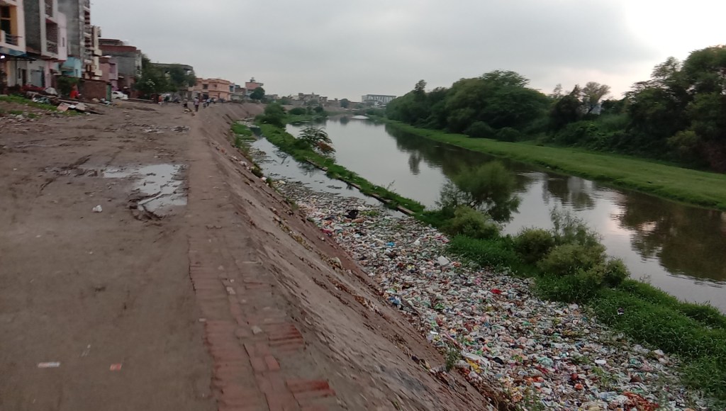
Ludhiana Buddha nullah, once ‘centre of social life, became most toxic water body The story of evolution of Buddha Nullah in Sutlej basin in Punjab, to the most polluted stream of the state. The Buddha nullah picks up toxic effluents in massive quantities and around 200 MLD of untreated sewage a day before it meets the Sutlej river. “The Buddha nullah accounts for 90 percent of the pollution in Sutlej river,” says KS Pannu, Punjab’s Director of Environment and Climate Change. The contaminated water is further distributed through canals for irrigation in the entire Malwa region of the state and parts of Rajasthan.
– A Punjab Agriculture University study had found the presence of mercury, cadmium, chromium, copper, and other carcinogens in vegetables and crops grown in villages along the length of the nullah. After the confluence of its water into Sutlej, the river’s water attains the Class E status in terms of pollution, meaning not fit for any use and does not sustain any aquatic life. “Buddha Nullah is the most dangerous and toxic water body in Punjab, which affects the lives of over 2 crore citizens in Punjab and Rajasthan,” says Sant Balbir Singh Seechewal. Today, the city’s residents are entirely dependent on groundwater to meet their drinking water needs. The nullah has led to the contamination of groundwater along its entire course, which has led to frequent outbreaks of diseases. “The entire population of Ludhiana is at risk,” says a local doctor, Arun Chatwal. https://www.firstpost.com/india/how-ludhianas-buddha-nullah-once-centre-of-social-life-became-punjabs-most-toxic-water-body-8629141.html (23 July 2020)
RIVERS
River Language Article (Marathi) by Parineeta Dandekar in Loksatta on July 25, 2020 on river names and language. https://www.loksatta.com/bara-gaoncha-pani-news/article-on-dialect-of-rivers-abn-97-2226680/
GANGA Chardham project and court This shows that even military did not need WIDE char dham road that the govt is pushing for. https://ourbitcoinnews.com/chardham-project-and-court/ (20 July 2020)
HPC report says socio-cultural concern, innovative thought ‘largely missing’ “Though the Char Dham tourism circuit is promoted as religious tourism in Uttarakhand, the widened highways have no footpaths for the devout padyatris, who undertake the devotional form of the yatra, as well as for the local pedestrians.” The committee in its final report also revealed that muck dumping at unauthorized sites has severely degraded riverine vegetation that cannot be regenerated at any other type of habitats. This has affected the biota of mountain streams and rivers and may force resident small fauna, primates, wild pigs, porcupines and snakes into the nearby trees and human settlements contributing to human-animal conflict. Suggestions by the committee in the report includes detailed and comprehensive geological, geophysical and geotechnical investigations and to consider ways of minimizing the anticipated economic impacts on the affected communities. https://www.newindianexpress.com/nation/2020/jul/21/char-dham-pariyojana-hpc-report-says-socio-cultural-concern-innovative-thought-largely-missing-2172741.html (21 July 2020)
SC Panel spilt on the width of roads Most of the members of the ‘majority’ group are affiliated to the Uttarakhand government or Central Ministries, whereas as three of four members who have signed on the ‘main’ report are independent experts. It later emerged that the government’s own Ministry of Road Transport and Highways (MoRTH), had in March 2018, recommended against ‘double laning and paved shoulders’ in hilly terrain and recommended a narrower intermediate road width. However, both reports are unanimous that the MoRTH, the ultimate implementer of the project, had broken the entire CD project into 53 different projects, all less that 100 km long, to avoid the need for an Environment Impact Assessment. Ravi Chopra adds, “Compromising the Himalayas further, especially in the closely set Char Dham valleys, over and above all the existing cumulative pressures would be a grievous mistake with far reaching consequences.” https://www.thehindu.com/news/national/other-states/chardham-project-supreme-court-panel-split-on-width-of-access-roads/article32142588.ece (20 July 2020)
YAMUNA Delhi Debris on Yamuna floodplain yet to be removed Thanks to posting of the photo, video on twitter with tag to CPCB, DJB, DDA, Yamuna Monitoring Committee of NGT by Bhim Singh Rawat of SANDRP: https://timesofindia.indiatimes.com/city/delhi/delhi-debris-on-floodplain-yet-to-be-removed/articleshow/77118015.cms (23 July 2020)
In Feb. 2020, SANDRP has raised the issue of dumping of debris in Yamuna riverbed near CWG village. After this, NGT monitoring committee, DDA and CPCB have assured of actions. However this July 21, 2020 video shows that most of debris dumped along and near bridges, metro line have been levelled there further increasing the riverbed. The illegal act has eaten into flood passage space of river. The annual flood is round the corner. The debris levelled would create a bottle neck situation there. CPCB has again asked DDA to take action. https://www.facebook.com/sandrp.in/posts/3609781895716124
For more information, kindly see: https://sandrp.in/2020/02/24/despite-ngt-order-and-yamuna-monitoring-committee-cpcb-dda-responses-action-awaited-about-dumping-on-yamuna-floodplain/
Uttar Pradesh July 20, video by Nakul Shashtri shows its business as usual for Yamuna downstream Gokul Barrage, Mathura as so far there has been no flood spell in river, despite 7 weeks of monsoon season 2020 are gone by. https://www.facebook.com/sandrp.in/posts/3605375242823456
FISH, FISHERIES, FISHERFOLKS
Policy National Fisheries Policy neglects fishing communities, environment Fishermen bodies, marine experts and other experts working with the fisheries sector feel that the policy is export-oriented, production-driven and based on capital investments. They feel that it is neither protecting the interest of the fishing communities nor the environment. https://india.mongabay.com/2020/07/draft-national-fisheries-policy-seeks-big-growth-but-ignores-fishers/ (July 24, 2020)
SAND MINING
SANDRP Blog Bihar Sand Mining 2020: Ruining rivers; aggravating floods This report paints rather gloomy and eye popping picture of sand mining in Bihar. While Son River seems to be facing the maximum impacts of mostly illegal sand mining, including violence, Ganga is also seen by researchers shifting it course at Patna, partly due to unsustainable sand mining.

The Judiciary, including NGT has been trying its best appointing committee after committee, the state came out with a new policy, CAG report has pointed out massive revenue holes due to illegal sand mining and the state done nothing to set up District Mineral Foundation as required by law. Disappointing to see no change here in Nitish Kumar rule, known for Sushashan (Good governance). There is no sign of it here. Plz Read, Share and send comments. https://sandrp.in/2020/07/22/bihar-sand-mining-2020-ruining-rivers-aggravating-floods/ (22 July 2020)
Gujarat Four drown in quarry pit Four persons, including three teenage cousins, drowned in a water-filled pit at a defunct stone quarry in Devbhumi Dwarka district of Gujarat on Saturday (JULY 25, 2020) morning near Dharampur village, an official of Khambhalia police station said. https://timesofindia.indiatimes.com/city/ahmedabad/gujarat-three-cousins-their-kin-drown-in-water-filled-pit-at-quarry/articleshow/77165245.cms (25 July 2020)
Uttarakhand Despite repeated pleas, the state govt had not removed the illegal mining bridge built across Yamuna river in Hari Pur, Vikas Nagar by July 23, 2020, It has now been removed, see news below. With increase in water level it has started wearing away and could lead to flood disaster on event of heavy rain or flash floods. https://www.facebook.com/sandrp.in/posts/3609652189062428
YAMUNA BRIDGE REMOVED! A makeshift bridge on Yamuna, constructed within 500 metres from the permanent bridge in Haripur, has now been removed by the miners on the instructions of local administration. On Saturday (July 25), the exhume pipes used for the construction of the makeshift bridge were being removed. The bridge was being constructed by miners allegedly in violation of the guidelines by the Union ministry of environment, forest, and climate change on mining. https://timesofindia.indiatimes.com/city/dehradun/toi-impact-makeshift-bridge-from-yamuna-removed/articleshow/77173751.cms (26 July 2020)
Gaon Connection republishes SANDRP’s blog on illegal mining bridge on Yamuna river in Haripur, Vikas Nagar, which govt is not removing despite many pleas. https://en.gaonconnection.com/to-prevent-flood-disaster-in-uttarakhand-the-state-govt-must-remove-illegal-bridge-on-yamuna/ (23 July 2020)
Haryana Uttar Pradesh NGT asks govts to submit report on illegal mining in Yamunanagar In the hearing of the application 87/2020 to take measures against illegal mechanized in-stream riverbed mining on the banks of Yamuna near Gumthala north and south blocks in Yamunanagar district of Haryana and Nangla Rai village in Kairana block of Shamli district in Uttar Pradesh (UP), the NGT sought factual and action taken report against illegal mining by the joint committees of both states. https://timesofindia.indiatimes.com/city/gurgaon/ngt-seeks-report-on-illegal-mining-along-yamuna-river/articleshow/77172248.cms (25 July 2020)
Uttar Pradesh This says in last one week, five people have died after drowning in Yamuna river in Kairana block. The river stretch was under massive scale illegal mining and local people are blaming deep sand pits responsible for these deaths.
यमुना में होने वाली अवैध रेत खनन के कारण यहां गहरे कुंड बने हुए हैं। जिससे हर साल स्नान के दौरान दर्जनों जिदगी काल के गाल में समा रही हैं। प्रशासन की ओर से नदी पर कोई नोटिस या सचेत करने को बोर्ड भी नहीं लगाया गया है। यमुना नदी पर प्रशासन की व्यवस्था पर भी अक्सर सवाल खड़े होते रहे हैं। श्रद्धालु कहते हैं कि यदि यमुना नदी पर पक्का घाट बन जाए तो हर साल डूबने वाले लोगों की जिदगी बच सकती है। शासन-प्रशासन की अनदेखी के कारण अभी तक समस्या का समाधान नहीं हो सका है। https://www.jagran.com/uttar-pradesh/shamli-city-people-facing-problem-during-bath-in-yamuna-20545989.html (23 July 2020)
In Sept. 2019, seven children from Malakpur village Kairana had accidentally fallen in Yamuna river and six of them never returned. Report and locals had even then held deep illegal sand mine pits dug across riverbed leading to mishap. https://www.uniquesamay.com/happiness-changes-in-mourning-6-families-break-a-mountain-of-gum-together-the-whole-village-weeps/ (17 Sept. 2020)
Telangana TSMDC earns Rs 230 crore; about 38.1 lakh cubic metres of sand sold within 40 days. https://telanganatoday.com/telangana-reaps-it-rich-in-sand-sale (20 July 2020)
Report Global appetite for sand is fueling a crisis Next to water, sand is our most consumed natural resource. The global demand for sand and gravel stands between 40 billion and 50 billion tonnes annually, according to the UNEP, and its scarcity is an emerging global crisis. The world may run out of sand if we do not start paying attention to sand as a resource that needs research, management and governance. https://www.eco-business.com/opinion/roving-bandits-and-looted-coastlines-how-the-global-appetite-for-sand-is-fuelling-a-crisis/ (08 May 2020)
WETLANDS, LAKES, WATER BODIES
Tamil Nadu Children make art to save Vedanthangal Bird Sanctuary FASCINATING: Protection of Vedanthangal bird sanctuary. Over the Eastern and Northern embankments of the lake, hundreds of acres of paddy fields abound. Irrigation canals from the bund take the lake’s water into these fields.
– Vedanthangal is a centuries old lake and bird haven. It is an Eri – a traditional manmade reservoir in South India, to conserve water. It is one among nearly two thousand of them in Kanchipuram and Chengalpet districts. Each Eri is part of a larger cascading system of reservoirs, linked by overflow from rivers and each other. This region is traversed by only seasonal rainfed rivers, which flow for a few months. The rest of the year is dry. People built Eri-systems to store rainwater, prevent flooding and recharge ground water for yearlong use. This is known to have transformed this landscape. The oldest known inscription on Eri-science is from 1291 AD in Cuddapah, Andhra Pradesh.
– Vedanthangal is one such Eri, with an extraordinary history. Vedan in Tamil is ‘hunter’. ‘Thangal’ is a reservoir, often a protected one. The name has been interpreted both as ‘hunter’s reservoir’ and as ‘a reservoir protected from hunters’. The latter meaning rings truer. The agrarian community in this village understood that when water mixed with bird guano is used to irrigate their paddy fields, their yield is abundant. Hence this lake has been a community-protected heronry for centuries. It has been built such that its embankments fade into grassland and scrub to its West and Northwest, where its catchment is open to the floodplains of Cheyyar river. http://vikalpsangam.org/article/vedanthangal-art-to-save/ (20 July 2020)
Village goes without streetlights for 35 days to make home for birds and its chicks Living up to the fabled tale of Tamil King Pari — one of the seven great patrons (kadai ezhu vallalgal) of the Sangam era who abandoned his golden chariot to help a climber take root — a village in Sethambal pachayat near Maravamangalam in Sivaganga district has gone dark without streetlights for more than a month now to save the hatchlings of an Indian Robbin (Copsychus fulicatus) that had turned the village’s community switchboard into its nest. https://timesofindia.indiatimes.com/city/madurai/tn-village-goes-without-streetlights-for-35-days-to-make-home-for-bird-and-its-chicks/articleshow/77116723.cms (23 July 2020)
Assam Huge explosion near Baghjan oil well in Assam, 3 foreign experts injured The damaged gas well is spewing gas uncontrollably for 56 days since a blowout – an uncontrolled release of gas and oil condensate – took place on May 27. Two firefighters of OIL also died at the site then. https://www.hindustantimes.com/india-news/huge-explosion-near-baghjan-oil-well-in-assam-3-foreign-experts-injured/story-aqT12p78JewpkBv89MYigI.html (22 July 2020)
Biodiversity impact on Dibru Saikhowa wetlands This fascinating report provides great details and exposes several key issues around ongoing OIL well blow out close to Dibru Saikhowa National Park in Upper Assam. https://longform.storiesasia.org/the-devastation-assam-blowout-caused (July 2020)
World Mangroves Day Justice Rocks’ latest production spotlights the women fishers that care and are cared for by the mangroves of Ennore Pulicat wetlands. On World Mangroves Day (26 July), we remind you that not too far from Chennai in the sprawling patchwork of mangroves, salt marshes, perennial channels and deepwater pockets of the Ennore Pulicat wetlands, a lopsided battle is playing out — with more than 2000 dalit and rural women fishers on the one side and the Government of Tamil Nadu, Kamarajar Port, TANGEDCO and Adani Ports on the other.
The women have successfully raised entire families from the income provided by the waters made bountiful by the mangroves. The Government wants to convert large tracts of this waterscape into industrial real estate. Join the fight to save the Ennore Pulicat wetlands. https://www.youtube.com/watch?v=ZvOU_OLJvSg (26 July 2020)
WATER OPTIONS
Jharkhand Villagers build 700 check dams From strengthening Gram Sabha to shunning alcoholism, IFS officer motivates villagers to transform their lives through ‘shramdaan’, which helped them build 700 check-dams. 110 households in Ara and Keram villages under Ormanjhi Block, located about 45 km from Jharkhand capital Ranchi. From being economically and socially backward three years ago. To being mentioned in Mann ki Baat by PM. Thanks to Siddharth Tripathi, IFS, posted as Commissioner (MGNREGA).
– Ara and Keram villagers did wonders through ‘Loose Boulder Structure’ (LBS), an indigenous method to conserve water. Boulders were arranged in a pattern to harness the flow of water from the mountains, allowing it to pass through the boulders towards the agricultural fields. “This required ‘shramdaan’ of 180 villagers’ non-stop for 75 days during which 700 LBS check-dams worth Rs 1.75 crore were built,” said Gram Pradhan of Keram village Rameshwar Bedia. This resulted in stopping soil erosion, and also facilitated recharging the water- table in the agricultural fields, he said. https://www.newindianexpress.com/good-news/2020/jul/19/agent-of-change-motivated-by-ifs-officer-jharkhand-villagers-build-700-check-dams-2171696.html (19 July 2020)
GROUNDWATER
NGT Recommends No General Permission For Groundwater Withdrawal Without EIA “There must be no general permission for withdrawal of groundwater, particularly to any commercial entity, without an environment impact assessment of such activity on individual assessment units in cumulative terms covering carrying capacity aspects by an expert committee,” an NGT bench headed by its chairperson AK Goel said on July 20, 2020. The tribunal also expressed unhappiness with the Central Ground Water Board’s (CGWB) submission that the restriction on the extraction of groundwater in overexploited, and critical and semi-critical areas are likely to have an adverse impact on industrial production, employment opportunities and GDP of some states.
– “Any permission should be for specified times and a specified quantity of water, not in perpetuity, and be necessarily subject to digital flow meters which cannot be accessed by proponents, with mandatory annual calibration by an authorised agency at proponents’ cost,” the NGT bench said. “An annual review by independent and expert evaluation must audit and record groundwater levels as well as compliance with the conditions of the permission. Such audits must be published online for transparency and to track compliance and year-on-year change in groundwater levels. Swift action should be taken against those who fail the audit, including withdrawal of permission, blacklisting, initiation of prosecution and recovery of deterrent compensation as per Central Pollution Control Board (CPCB) regime. Records must be maintained online and for a sufficient and reasonable time,” the tribunal observed.
The NGT ordered that all over-exploited, critical and semi-critical (OCS) assessment units must undergo water mapping. Water Management Plans need to be prepared for all OCS assessment units in the country based on the mapping data, starting with overexploited blocks, the bench said.
“The Water Management Plans, data on water availability or scarcity and policy of CGWA must be uploaded on its website for transparency and public involvement. Such exercise may be done expeditiously, preferably within the next three months,” the NGT said while asking the government to file an action taken report.
– The NGT said that the Ministry of Jal Shakti (MoJS) may ensure requisite manning and effective functioning of Central Ground Water Authority (CGWA), so as to ensure sustainable groundwater management in terms of the Supreme Court mandate by which CGWA was created.
The NGT also asked CGWA and MoJS to comply with the directions of this tribunal in orders dated January 3, 2019, May 7, 2019, and September 11, 2019, to have a meaningful regulatory regime and institutional mechanisms for ensuring prevention of depletion and unauthorised extraction of groundwater and sustainable management of groundwater in OCS areas. Listed for Feb 11, 2021. http://www.businessworld.in/article/NGT-recommends-no-general-permission-for-groundwater-withdrawal-without-environment-impact-assessment/20-07-2020-299354/ (20 July 2020)
NGT slams centre over groundwater extraction The green panel refused to review its order disallowing grant of ‘No Objection Certificate’ to industries in OCS areas and said exemptions for infrastructure projects, Micro, Small & Medium Enterprises or other industries or commercial purposes except drinking water will be against sustainable development and public trust doctrine.
-The tribunal directed the Ministry of Jal Shakti and the Central Ground Water Authority to ensure that no general permission be given for the withdrawal of groundwater, particularly to any commercial entity, without carrying out an environmental impact assessment. https://www.livemint.com/news/world/ngt-slams-centre-over-groundwater-extraction-11595241606335.html (20 July 2020)
NGT pulls up Jal Shakti, CGWADispleased over the Centre’s submission that restriction on groundwater extraction in over-exploited, critical and semi-critical (OCS) areas is likely to have an adverse impact on industrial production, employment opportunities and GDP of some states, the National Green Tribunal (NGT) has pulled it up. The panel has refused to review its order disallowing grant of ‘No Objection Certificate’ to industries in OCS areas. It has ordered the Ministry of Jal Shakti and the Central Ground Water Authority to ensure that no general permission be given for the withdrawal of groundwater, particularly to any commercial entity, without carrying out an environmental impact assessment. https://www.ndtv.com/india-news/national-green-tribunal-pulls-up-centre-over-groundwater-extraction-in-dry-areas-2265854 (20 July 2020)
Haryana HC orders govt o protect water bodies With an aim to ensure improvement in recharge mechanism, the Punjab and Haryana High Court has directed Haryana to revive, preserve, conserve and protect all water bodies in the state. The direction has come following the petition filed that challenged an earlier order to panchayats in Kurukshetra for replacement of paddy by other crops for checking groundwater depletion. https://www.tribuneindia.com/news/haryana/punjab-and-haryana-high-court-revive-preserve-water-bodies-111164 (11 July 2020)
HSPCB recommends action against 7 Panipat industriesThe Haryana State Pollution Control Board (HSPCB) in a report submitted to the National Green Tribunal (NGT) has mentioned seven industrial units in Panipat that were drawing groundwater without permission and others that were violating the environmental norms. The matter came to light after Ramesh Kumar of Panipat’s Khandra village in February this year approached the NGT alleging pollution by dyeing industries in Assan and nearby villages. https://www.hindustantimes.com/cities/withdrawal-of-groundwater-haryana-pollution-control-board-recommends-action-against-7-industrial-units/story-q0v3YeGrBx8Y7opPIAlShJ.html (22 July 2020)
Bloomberg India’s Water Crisis Is Becoming a Problem On a scorching summer day in northern India, Ajay Singh sat next to his water pump and scanned his 10 acres of farmland in Karnal (Haryana). He once used to grow rice each season to bring in about 150,000 rupees ($2,000) a year, well above the average income in the world’s second-most populous country. Now on six acres he’s cultivating pearl millet, cow peas, bottle gourd and corn — crops that consume about 80% less water than rice, and also use less labor, fertilizer and electricity. While a water conservation program pays him 7,000 ($93) rupees per acre to plant them, it’s still a gamble: Unlike rice, which the government always buys at a set price, these crops have no guaranteed market.
– “Sooner or later, it will have to be replicated across the country. Ideally, the central government should finance part of the expenditure in providing incentives to the farmers for making the shift from paddy and sugarcane. States alone can not afford such an ambitious plan.” says Siraj Hussain, former Agriculture Secretary, GoI. https://www.bloombergquint.com/economy-finance/india-water-crisis-forces-farmers-to-rethink-their-crops (22 July 2020)
Uttar Pradesh GW depletion in Greater NOIDAThe groundwater table has receded below 30 metres in the city, one of the worst depletions recorded so far, reveals the pre-monsoon assessment by the groundwater department. According to the limited assessment (it did not include all the spots where assessment is done in Gautam Budh Nagar), the deepest point in Gautam Budh Nagar where water could be found was 30.38m — approximately 10 storeys deep — at the Govt Degree College in Noida. The water table here fell by 2.32m from 28.06m in 2019.
-Officials said the only good news was that even though the groundwater level has dropped, the average drop has reduced as compared to previous years. According to the report, while the annual drop in Noida was 1.792m since 2017, it was 1.44m as per the limited pre-monsoon assessment. The assessment was done between June 27 and July 1.
-According to the UP groundwater department statistics, the two development blocks of Bisrakh (149.19% groundwater usage) and Jewar (108.81%) in Gautam Budh Nagar are already in the overexploited category. The Dadri block (84.50%) is semi-critical while the Dankaur block (99.84%) is in the critical category. https://www.hindustantimes.com/noida/gb-nagar-groundwater-table-depletes-again-worst-decline-in-greater-noida-s-gulistanpur/story-mCg1rURcYaZVzQCsG683eK.html July 24, 2020
URBAN WATER
SANDRP Blog Delhi’s drinking water canal gets a toxic mix
In May 2019 SANDRP wrote, with photo evidence, after a visit to the Drain No 8 that brings Delhi’s drinking water that it is running next to drain no 6 carrying untreated industrial toxics from Haryana, with only sand bags separating the two. A visit on July 21 2020, provided Photo and video proof that water from drain no 6 is happily mixing with drain no 8 at several places. https://sandrp.in/2020/07/24/delhi-drinking-water-canal-gets-toxic-mix/ (24 July 2020)
The July 21 video shows Drain Number 6, which carries industrial effluents in large amount is over spilling in Drain Number 8 transport potable water supply to Delhi. Both drains run parallel and this problem exists for many years. Govt of both state have been informed several times but situation has not changed at all. https://www.facebook.com/sandrp.in/posts/3609668099060837
This July 21, video shares some basic information about drain number 8 and 6 and how Delhi’s potable water quality is severely threatened by industries in Sonipat district. https://www.facebook.com/sandrp.in/posts/3613759368651710
For more information pls see: https://sandrp.in/2019/05/16/delhis-drinking-water-is-9-inch-wall-away-from-toxic-industrial-effluents-sewage/ (16 May 2019)
This shows following recent light rainy spell, industrial pollution via drain no. 6 Sonipat and drain no. 2 in Panipat has affected Delhi’s water supply as highlighted by SANDRP in latest blog. https://www.outlookindia.com/newsscroll/high-pollution-levels-in-yamuna-hit-water-supply-in-delhi/1902074 (24 July 2020)
High ammonia in Delhi waterThis has become a routine affair, as Delhi, Haryana and Central govt agencies have turned insensitive, indifferent towards ongoing pollution of Delhi’s water sources through DN 8, Sonipat, DN 2 Panipat, Dhanaura Escape Karnal:-Water treatment plants in Wazirabad, Chandrawal and Okhla were on Friday (July 24) forced to curtail production due to high levels of pollutants in the Yamuna river, the Delhi Jal Board said. The water utility said it was trying to rationalise supply and therefore, water will be available at low pressure till the situation improves.
-“Due to high levels of pollutants being received in the Yamuna…, water production has been curtailed from treatment plants in Wazirabad, Chandrawal and Okhla,” the DJB said in a statement.
The affected areas are parts of West Delhi, North Delhi, Central Delhi, South Delhi, Delhi Cantonment and New Delhi Municipal Council areas, it said. The utility has urged the public to make judicious use of water. https://timesofindia.indiatimes.com/city/delhi/high-pollution-levels-in-yamuna-hit-water-supply-in-delhi/articleshow/77156363.cms (24 July 2020)
Unfortunately, media seems to have largely ignored the issue raised by SANDRP blog, so far.
Pune Water for Wagholi: Rs 22-cr pipeline project started The work for laying a dedicated water supply line for Wagholi has started after a follow up of more than two years by local residents. The Rs 22 crore worth 5 MLD water pipeline project will solve the decade-old water crisis in the area.
-HT had highlighted the crisis two years ago, despite paying taxes to the Pune Metropolitan Regional Development Authority (PMRDA) the residents of Wagholi were subject to buying water and the residential societies’ total expenditure for water was more than Rs 50 crore annually. This included the bills of private water tanker owners. https://www.hindustantimes.com/pune-news/water-for-wagholi-rs-22-cr-pipeline-project-kicks-off/story-Mtdcpe2SJubD8bmRfiIxyI.html (21 July 2020)
Punjab Govt approves world bank-supported US$ 286 million canal water supply project for Amritsar, Ludhiana The International Bank for Reconstruction and Development (IBRD) would finance US$ 200 million (70%) and Punjab Government US$ 85.71 million (30%), as per the proposal mooted by the Local Government department for the adoption of Resettlement Policy Framework (RPF) under Punjab Municipal Services Improvement Project.
– The project would have four components including strengthening urban and water supply service management with a total cost of US$ 11.61 million, improving water supply infrastructure at US$ 240.38 million, besides Land Acquisition and Rehabilitation & Resettlement involving the cost of US$ 15.62 million, COVID-19 crisis response to the tune of US$ 10 million and project management at US$ 7.6 million, in addition to Front End Fee of US$ 0.5 million. https://www.tribuneindia.com/news/punjab/punjab-approves-world-bank-supported-us-286-million-canal-water-supply-project-for-amritsar-ludhiana-116419 (22 July 2020)
WATER POLLUTION
Delhi Yamuna polluted amid monsoon
Unusal in the middle of monsoon season, Yamuna river is seen frothing with toxic foam at Okhala barrage. The Washington post included a photo of this in its weekly pictorial report. https://www.aninews.in/news/national/general-news/delhi-yamuna-gets-polluted-again-as-lockdown-eases20200724181518/ (July 25, 2020)
NGT Monitoring Committee seeks report on Yamuna froth The two-member committee, comprising retired National Green Tribunal expert member B S Sajawan and former Delhi chief secretary Shailaja Chandra, asked CPCB, DPCC Chairman Sanjeev Khirwar and Industries Commissioner Vikas Anand to take prompt action to detect source of the froth in the river and act against those responsible. https://www.financialexpress.com/lifestyle/science/toxic-froth-in-yamuna-ngt-panel-seeks-report-from-cpcb-dpcc-on-frothing-in-yamuna/2035992/ (27 July 2020)
Material used to make sSurgical mask freshly dumped, signature bridge derbis still not fully removed from Yamuna river bank near Majnu ka Tilla. (July 25, 2020 video) https://www.facebook.com/sandrp.in/videos/724649581660230/
Uttar Pradesh Sad, in Agra, Yamuna river is turning polluted with each passing day with resumption in industrial activities. https://www.jagran.com/uttar-pradesh/agra-city-pollution-in-yamuna-river-is-increased-in-agra-as-unlock-began-jagran-special-20548099.html (24 July 2020)
AGRICULTURE
Center NITI CEO advice has no reflection in official programs of Govt Niti Aayog CEO Amitabh Kant on Wednesday (July 22, 2020) said there is a need to shift from rice to millet cultivation to reduce high water consumption. Kant also said millets are nutritious and rich in micronutrients, particularly protein and calcium, and they must be used in safety net schemes for women and children. https://www.financialexpress.com/economy/water-crisis-need-to-shift-from-rice-to-millet-cultivation-says-amitabh-kant/2032340/ (22 July 2019)
Punjab Is paddy planted using DSR method more vulnerable to rodent attacks? -Amid reports that paddy sown with Direct Seeding of Rice (DSR) technique has been attacked by rodents and farmers are facing big challenges in Punjab, some argue that sowing technique involving transplantation of seedlings in flooded fields insulates the crop from such attacks. Others believe that government must revive an old policy to control rodent attacks. https://indianexpress.com/article/explained/punjab-paddy-sowing-direct-seeding-of-rice-method-rodent-attack-6517734/ (21 July 2020)
MONSOON 2020
WII to study migration routes of Pied Cuckoo Interesting study being under taken by Wildlife Institute of India. https://indianexpress.com/article/india/pied-cuckoo-monsoon-climate-change-study-6522324/ (25 July 2020)
Uttarakhand Red alert in 5 districts A bulletin issued by Bikram Singh, director, Regional Meteorological Centre, stated, “Heavy to very heavy rainfall with intense to very intense spells is very likely (60% probability) to occur over Uttarkashi, Rudraprayag, Chamoli, Bageshwar and Pithoragarh districts of Uttarakhand between Tuesday and Thursday.” These districts are likely to experience landslides, boulder fall, overflowing of gushing streams and blockade or a washout of link roads. https://www.hindustantimes.com/india-news/imd-issues-red-alert-in-uttarakhand-s-five-districts-for-next-3-days/story-ySdjoWL3InpaoYyJX7h7iN.html (20 July 2020)
NASA map on Asian Monsoon 2020
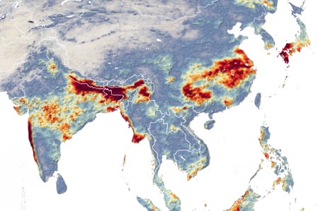
Satellite map from NASA showing above normal rainfall and flooding in South Asia and parts of China. https://earthobservatory.nasa.gov/images/147006/excessive-monsoon-rains-flood-asia, https://eoimages.gsfc.nasa.gov/images/imagerecords/147000/147006/asia_mrg_2020202_lrg.jpg
FLOOD 2020
Bihar
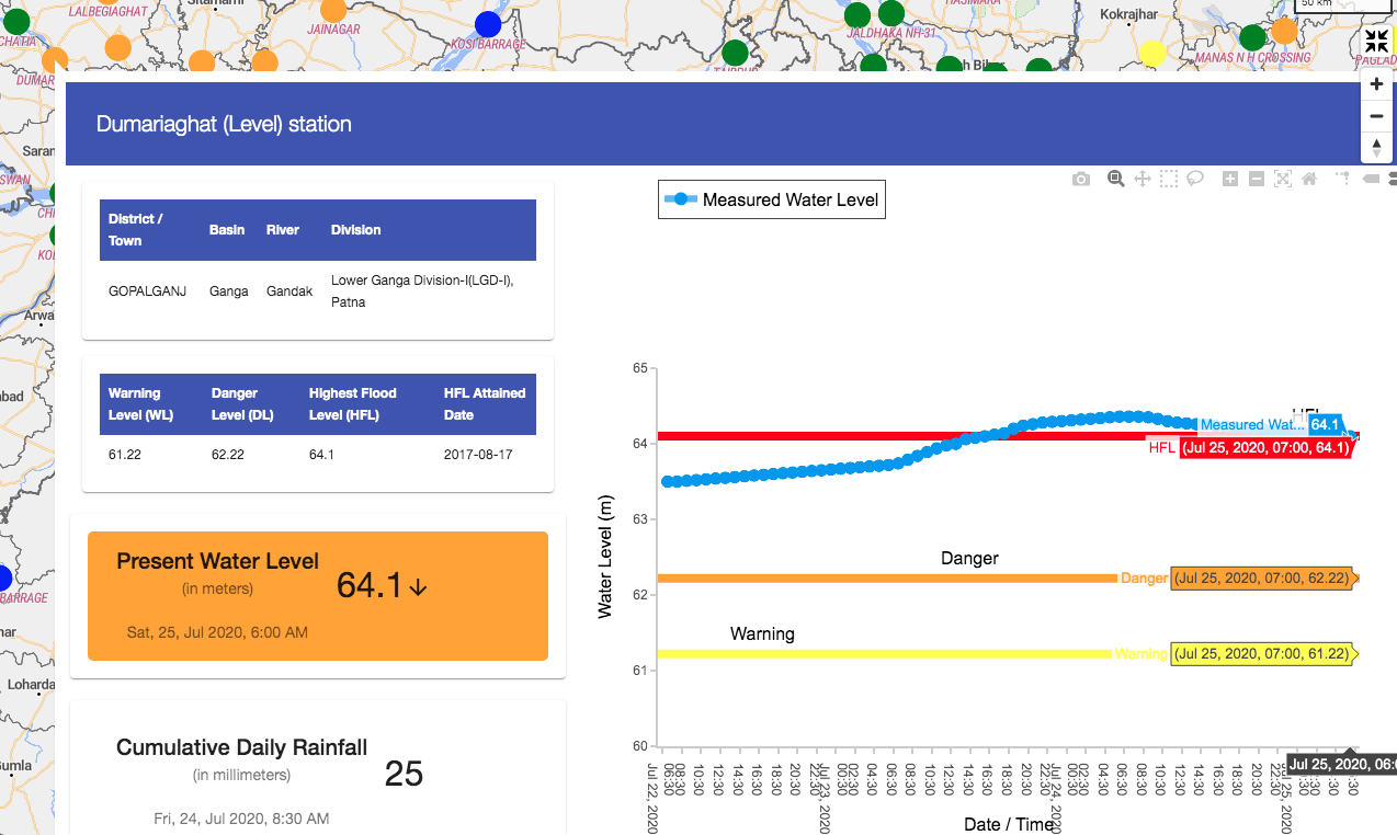
On July 24, 2020 ~06:00 hrs, River Gandak at Dumariaghat in Gopalganj dist has crossed previous HFL 64.1 m dated 17-08-2017 by 0.26 m setting new HFL at 64.36 m.
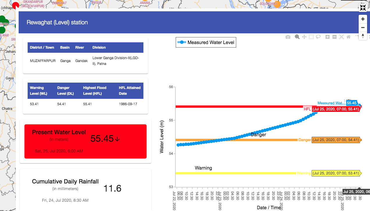
River Gandak has marginally crossed previous HFL 55.41 m attained on 17.09.1986 at Rewaghat site in Muzaffarpur dist by 0.05m setting new HFL 55.46 m on 24.07.2020.
Gandak river at Lalganj site, Vaishali dist crossed previous HFL 51.624 m attained on 04.08.2001 by ~0.13m thus setting new HFL 51.75 m on 25.07.2020 at 05:00 hrs. It remained above HFL for ~18 hrs.
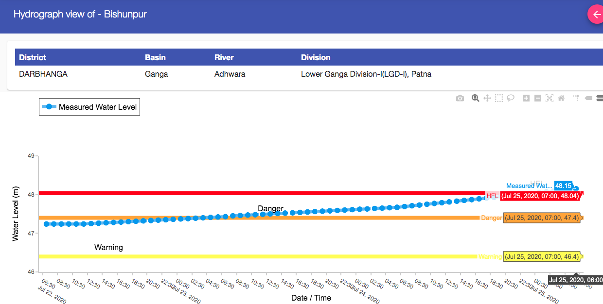
Adhwara river has crossed previous HFL 48.04 m attained on 24.08.2017 at Bishunpur site in Darbhanga dist at 04:00 hrs on 25.07.2020.
Gandak Embankment breach on July 24 Some details on embankment breach incidents in Bihar. https://www.abplive.com/news/india/in-gopalganj-bihar-flood-water-reached-five-hundred-villages-due-to-breach-of-saran-embankment-ann-1499835 (July 24, 2020)
Breach in Gandak river embankment has caused flooding in dozens of village in Gopalganj late on July 23 night. https://www.livehindustan.com/bihar/story-devastation-in-bihar-from-flood-gandak-uncontrolled-and-embankment-broken-in-gopalganj-after-water-released-from-valmiki-nagar-barrage-of-nepal-more-than-12-villages-of-two-blocks-submerged-3371645.html (24 July 2020)
Discussion with CWC Chairperson on Bihar floods: https://www.youtube.com/watch?v=QNkdF5-J-I0&feature=youtu.be
Collapse of new Bridge Approach Road on GandakA small bridge that connected Gopalgang to Chhapra and other districts was washed away by a swollen Gandak river last week. The bridge, worth Rs 264 crore, was constructed in eight years and collapsed in 29 days of its inauguration. As per engineers, the collapse could be attributed to either not taking into account the levels of rise in Gandak river during floods or the poor quality of work. https://theprint.in/india/bihar-bridge-collapses-month-after-inauguration-opposition-says-nitish-corruption-exposed/462242/ (16 July 2020)
Krishna Basin Possibility of Dam induced floods? This is pretty frightening situation once again. Almatti, Narayanpur and Jurala are almost full. Srisailam and Nagarunsagar also has substantial storage. Upstream dams are also mostly full…. and there is forecast of heavy rains and inflows….. All in violation of Reservoir Operation Schedules and inviting flood disaster…. CWC ideologues will of course stand up to say oh but the rains were so high.https://www.thehindubusinessline.com/news/national/srisailam-nagarjunasagar-dams-get-huge-inflows-as-karnataka-dams-discharge-flood-water/article32174518.ece (July 24, 2020)
Dam Floods Assam Houses flooded in Nagaon due to release of water from dam in Karbi Anglong Hundreds of houses in the Raha area of Nagaon district got flooded on Tuesday (July 21) after water was released from a dam of Karbi Langpi hydropower project in Karbi Anglong. Priyanka Bonia, Circle Officer of Raha, said the several villages have been affected including Madhavpura, Juripar, Jorabari, Magurgaon, Amtala and Kamargaon. https://timesofindia.indiatimes.com/india/houses-flooded-in-assams-nagaon-due-to-release-of-water-from-dam-in-karbi-anglong/articleshow/77087823.cms (21 July 2020)
Flood situation has worsened after gates of the Karbi Langpi Hydro Electric Project were opened to release at least 25 meters of water in Karbi Anglong district of Assam on Friday (July 24, 2020). Speaking to ANI, a resident of Nagaon district said, “Our lives were already affected but the situation got worse after the gates of a dam were opened without notifying the people.”
– “The houses of the people living in the nearby area have been submerged in the flood and rainwater. It has also destroyed the crops in the farms,” said a villager. He further said, “The dam water has destroyed the house of seven families in Madhavpur village. Neither the MLA has helped them in any way nor the government have come to aid. In fact, locals are using their own boats to travel amid the flood.” https://www.newkerala.com/news/2020/131767.htm
Dams can help or harm in flood disaster Himanshu Thakkar, the coordinator of the South Asia Network of Dams, Rivers and People, said effective management of dams could bring down the damage caused by floods. “We have over 5,000 dams. Every dam can help moderate floods in the downstream area but only if it is operated properly,” Thakkar said. Thakkar raised questions on embankments, saying hardly any cost benefit analysis has been done on this. “We are just mechanically going forward. We are encroaching upon flood plains and river beds and we are doing sand mining. All these add to the floods,” he said. https://www.newindianexpress.com/nation/2020/jul/26/as-assam-reels-under-floods-data-shows-havoc-increasing-annually-2174788.html (July 25, 2020)
Assam ब्रह्मपुत्र को बांधने के खेल में है असम की बाढ़ का कारण One of the best reports on Brahmaputra floods: https://www.ndtv.com/video/shows/prime-time/can-this-damage-by-floods-be-prevented-in-assam-555121 (20 July 2020)
Asking flood questions from people’s perspectiveWhat if we started listening to the people who wanted to move to a newly formed char? After all, we imposed these property lines and we can undo them too. Perhaps we can then begin to accept that some of the residents of these disappearing villages, who know how best to work the land, should be able to choose how they want to move as the rivers move. Might it be that some might prefer to move with the shifting land and rivers than retreat to the polluted airs of the higher ground? We won’t know the answer if we don’t ask. https://www.telegraphindia.com/amp/opinion/is-concrete-the-way-forward-in-rebuilding-the-sunderbans/cid/1784882 (01 July 2020)
More frequent flood waves this year in Assam This year heavy rains, almost without any long break, has led to more suffering for the state’s residents who are already witnessing the third wave of floods this monsoon. “Usually we have a gap period between successive waves of floods in Assam, which allows water level in rivers to come down and flood waters to dry. But this year rainfall has been almost continuous for weeks and it has aggravated the situation. This is unusual,” said eminent water expert Dulal Goswami. https://www.hindustantimes.com/india-news/unrelenting-floods-without-respite-add-to-assam-s-plight-this-monsoon/story-XQVNjX4fUwKRv3m2WE6UFJ.html (24 July 2020)
Annual Assam Floods: Some Solutions -In this comprehensive video report; The Quint Team (Producer and Animator: Puneet Bhatia and narrator: Saakhi Chadha) highlights several important issues causing and aggravating flood situation in Brahmaputra rivers and Assam state every year.
Is There a Solution?
The Brahmaputra cannot be tamed. Flooding will become more intense in years to come. But how do we minimise the destruction?
Himanshu Thakker, Head, SANDRP, suggests:
– Better Flood forecasting. Information about floods forecasts must reach the affected villages in time.
– Strengthen only those embankments that are really needed. And, do not build more embankments. Create more room for the river, not restrict it.
– Ban all construction on low-lying floodplains.
Perhaps it’s time we stop normalising the yearly destruction and act, not react. https://youtu.be/5KQ4_1WpjOs (22 July 2020)
Opinion Engineering a season of floods by Amitangshu Acharya Outdated ideas of constructing dams and embankments have increased monsoon floods in India. The attempt to control rivers is the result of a British colonial hangover, even though western countries are moving away from dams. Such stories reveal how rivers used to generate prosperity, not misfortune. “Rivers of sorrow” are not produced by nature, they emerge out of engineering misadventures. In independent India, approximately 35,199km of embankments have been built around rivers as well as 4,728 large dams. Ironically, the flood-affected area of the country increased from 25 million hectares in 1952 to 49 million hectares in 2011. https://www.livemint.com/mint-lounge/features/engineering-a-season-of-floods-11573832077930.html (18 Nov. 2019)
Highland & corridors shelter Kaziranga rhinos But still, artificial highlands have their critics. Uttam Saikia, Honorary Wildlife Warden of the park, warned that these “highlands should not come up in the core areas of Kaziranga because it might damage the ecology”. “They can be built in the periphery and additional areas. Animals are forced to take shelter in these artificial highlands, the mountains are the natural highlands for them,” he said.
– However, Honorary Wildlife Warden Saikia contends that floods are essential to Kaziranga’s eco-system. “It’s a process that maintains ecological balance — deaths are a part of that process. For the last 100 years, we see that floods play a very important role in the natural balance. But obviously for us humans, we feel really bad,” he said. https://indianexpress.com/article/north-east-india/assam/assam-floods-kaziranga-rhinos-6515600/ (21 July 2020)
On Tuesday (July 21, 2020), the river that flows down from neighbouring Meghalaya swelled up due to heavy rains and breached its banks as the huge volume of water could not enter the overflowing Brahmaputra. https://www.ndtv.com/india-news/assam-floods-river-breaches-banks-in-district-near-guwahati-residents-evacuated-2267317 (23 July 2020)
LANDSLIDES
ENERGY OPTIONS
TERI sounds the alarm on damage to India’s electricity demand from Covid The Covid-19 pandemic will have a lasting impact on India’s electricity demand which will continue to face significant dent for years to come, according to a new report published by The Energy and Resources Institute on July 21, 2020. The report — authored by Thomas Spencer and titled “Bending the Curve: 2025 Forecasts for Electricity Demand by Sector and State in the Light of the COVID Epidemic” –said the COVID-19 crisis will lead to a sharp recession in the current year, adding, “The COVID-19 shock will lead to substantially slower electricity demand growth and a lower level of total demand even several years after the shock.”
– “In the Baseline Scenario, the electricity demand for 2025 is 11 per cent below the level it would have been by then without the COVID-19 shock. In the L-Shaped Scenario, electricity demand is 17 per cent below the level of the counterfactual without the COVID-19 shock,” the report said. https://energy.economictimes.indiatimes.com/news/power/teri-sounds-the-alarm-on-damage-to-indias-electricity-demand-from-covid/77092262 (21 July 2020)
ENVIRONMENT
CLIMATE CHANGE
Europe signs on Largest ever climate Deal After days of gruelling negotiation, the heads of state in the European Council have worked out what some are calling the largest climate package in history. The deal commits over half-a-trillion euros to climate action (over USD$500 billion). The deal raises the bar for climate funding globally just for its size. It is also politically significant because the package rests on consensus between 27 heads of state, each of whom knows that this agreement will have economic and political consequences for years to come. Despite fractious politics in the run up, the deal demonstrates the extent of underlying political agreement on climate action in Europe. Countries will draw up spending plans that will be vetted by the European Commission, the executive branch of the European Union. Indeed, the agreement this week stopped short of banning the use of funds in fossil fuel-intensive sectors. https://www.reuters.com/article/us-eu-summit-climate-change/eu-makes-worlds-biggest-green-recovery-pledge-but-will-it-hit-the-mark-idUSKCN24N231 (22 July 2020)
How glaciers in the western Himalayas are reacting differently to climate change and human activities Complex responses of the Glaciers to Climate Change and other anthropologic changes. https://india.mongabay.com/2020/07/how-glaciers-in-the-western-himalayas-are-reacting-differently-to-climate-change-and-human-activities/ (15 July 2020)
Europe Flood data of 500 years: Rivers and climate change Overflowing rivers can cause enormous problems: Worldwide, the annual damage caused by river floods is estimated at over 100 billion dollars – and it continues to rise. To date it has been unclear whether Europe is currently in a flood-rich period from a long-term perspective.
Austrian flood expert Prof. Günter Blöschl from TU Wien (Vienna) has led a large international study involving a total of 34 research groups that provides clear evidence that the past three decades were among the most flood-rich periods in Europe during the past 500 years, and that this period differs from others in terms of its extent, air temperatures and flood seasonality. Compared to the past, floods tend to be larger in many places, the timing has shifted and the relationship between flood occurrence and air temperatures has reversed. In the past, floods tended to occur more frequently in cold phases, while today, global warming is one of the main drivers of their increase. The results of the study have now been published in “Nature” magazine. https://www.eurekalert.org/pub_releases/2020-07/vuot-fdf072120.php (22 July 2020)
Denmark law that makes climate change illegalA rather remarkable piece of climate change legislation was passed this month by the Danish parliament with little fanfare. The BBC summarized the key features of this legislation in an article titled ‘The law that could make climate change illegal.’ This law attempts to innovate its way out of some fundamental legislative issues with existing climate laws. https://www.bbc.com/future/article/20200706-the-law-that-could-make-climate-change-illegal (08 July 2020)
India’s Climate Change report द वायर से बात करते हुए पर्यावरणविद हिमांशु ठक्कर ने कहा, ‘इसे जलवायु परिवर्तन पर भारत की पहली रिपोर्ट कहना गलत होगा. इससे पहले 2008 में तत्कालीन यूपीए सरकार ने जलवायु परिवर्तन पर राष्ट्रीय कार्य योजना का गठन किया था. इसके बाद पर्यावरण मंत्रालय ने भारत के जलवायु परिवर्तन पर एक रिपोर्ट निकाली थी, जिसे 4 X 4 रिपोर्ट कहा जाता था. उसमें भारत को चार भागों में बांटकर और चार नए मानदंडों के साथ रिपोर्ट तैयार की गई थी.’
– वे कहते हैं, ‘हम एक तरफ जंगल खत्म कर रहे हैं और दूसरी तरफ कह रहे हैं कि जलवायु परिवर्तन हो रहा है और ग्लोबल वार्मिंग हो रही है, ग्रीन हाउस गैस भी बढ़ रही हैं. हम कोयले का उपयोग ही नहीं बढ़ा रहे हैं बल्कि उसे निर्यात भी कर रहे हैं. इसलिए साथ-साथ हमें अपनी गतिविधियां भी देखनी होगी.’ ठक्कर ने कहा, ‘समस्या यह है सरकार यह स्पष्ट नहीं कर रही है कि हम पर्यावरण का क्या नुकसान कर रहे हैं. इन तीनों ही रिपोर्टों में इस बात पर बिल्कुल भी ध्यान नहीं दिया गया है कि इससे जनसंख्या का कौन-सा हिस्सा सबसे अधिक प्रभावित हो रहा है.’
– वह कहते हैं, ‘बारिश में कोई कमी नहीं है लेकिन उसका सही से वितरण नहीं हो पा रहा है. यही कारण है कि सूखे की संख्या भी बढ़ रही है और इसके साथ ही विनाशकारी बाढ़ की संख्या में भी बढ़ोतरी हो रही है. इस साल अभी तक पश्चिमोत्तर भारत में कम बारिश हुई है लेकिन देश के कुछ महत्वपूर्ण सूखाग्रस्त क्षेत्रों में सामान्य से अधिक बारिश हुई है.’ ठक्कर आगे कहते हैं कि हम बारिश पर कम बल्कि स्थानीय प्रणाली पर अधिक निर्भर हैं. लेकिन भूमिगत जल के प्रमुख संसाधनों को प्रक्रियागत तरीके से बर्बाद कर रहे हैं. जलवायु परिवर्तन को ध्यान में रखते हुए हमें स्थानीय प्रणाली को अधिक सुरक्षित और उनकी क्षमता बढ़ाने की जरूरत है. http://thewirehindi.com/132547/assessment-of-climate-change-over-the-indian-region-report/ (26 July 2020)
Scientists narrow likely temperature increase rangeFor more than 40 years, scientists have said greenhouse gases will warm the planet by between 1.5 and 4.5 degrees Celsius. Now, a team of researchers has sharply narrowed the range to between 2.6 and 4.1 degrees Celsius, and shifting it toward warmer outcomes. A climate scientist who reviewed the work said, “This is probably the most important paper I’ve read in years.”
– Steven Sherwood, a climate scientist at the University of New South Wales in Sydney, Australia, and an author of the new report said that the group’s research suggested that these temperature shifts, which are referred to as “climate sensitivity” because they reflect how sensitive the planet is to rising carbon dioxide levels, are now unlikely below the low end of the range. The research also suggests that the “alarmingly high sensitivities” of 5 degrees Celsius or higher are less likely, though they are “not impossible,” Dr. Sherwood said.
– The scientists noted that the Earth’s temperature is already about 1.2 degrees Celsius above preindustrial levels, and that, if current emissions trends continue, the doubling of atmospheric carbon dioxide could happen well before the end of this century. https://www.nytimes.com/2020/07/22/climate/global-warming-temperature-range.html (22 July 2020)
SOUTH ASIA
Bangladesh भूले–बिसरे मछुआरे
मेघना नदी के मुहाने और चटगाँव और कॉक्स बाज़ार के तटों के किनारे रहने वाले इन वंशानुगत मछुआरों- यह दलित समुदाय अब जलवायु परिवर्तन के सबसे भयावह प्रभावों में से एक का सामना करता है – के घरों को बंगाल की खाड़ी की लगभग हर उच्च ज्वार निगल जाती है। https://www.thethirdpole.net/hi/2020/04/22/the-forgotten-fisherfolk-of-bangladesh/ (22 April 2020)
Nepal Heavier than usual monsoon This year’s vigorous monsoon in Nepal has left at least 116 dead and 50 missing in landslides and floods, with Gandaki Province hardest hit by heavier than usual rainfall. Nawalparasi district in Gandaki Province received 312mm of rain between Sunday-Tuesday (July 19-21, 2020) with Monday registering 157mm in 24 hours. Bara district in the central Tarai recorded the highest precipitation in the period with 324mm of rain, and parts of Kaski district got 312mm.
– According to the Department of Meteorology and Hydrology, Nepal has received 736mm of rain since the start of the monsoon in mid-June – nearly 150mm more than the average for the same time period. Kaski and the mountains of central Nepal as well as the eastern districts have the highest annual precipitation in Nepal with 3,500mm. There has been many cloudburst events.
– On Monday (July 20) China officially informed Nepal that the Kerung Tso glacial lake near Khasa in Tibet was in danger of bursting, and the district administration in Sindhupalchok warned people to move to higher ground in the Bhote Kosi and sun Kosi Valleys. However, on Wednesday (July 22) the authorities downgraded the warning after the rains tapered off. The Bhote Kosi has seen frequent glacial lake outburst floods after lakes on the Chinese side of the Himalaya have burst during the monsoon. The last one was after the earthquake in August 2015. https://www.nepalitimes.com/latest/heavier-than-usual-monsoon-in-nepal/ (22 July 2020)
Disaster Risk Reduction Portal Summary shows large number of landslide related deaths this year since beginning of monsoon. http://drrportal.gov.np/summary
Fatal landaslides high in Nepal this monsoonDave Petley blog shows that the number of fatal landslides and fatalities in Nepal have gone up this monsoon already. https://blogs.agu.org/landslideblog/2020/07/24/nepal-2020/ (24 July 2020)
ASIA
International Rivers PR 2 Years After Lao Dam Collapse, Call for Justice Persists Two years ago today (July 23, 2018), at least 70 people died or disappeared and over 7000 were displaced when a dam collapsed in Laos, submerging homes, families and entire villages under a rushing wall of water. On the second anniversary of the disaster, those affected are yet to see justice. https://www.internationalrivers.org/resources/press-release-two-years-after-lao-dam-collapse-call-for-justice-persists-20617 (23 July 2020)
Thailand Chao Phraya River begins in Nakhon Sawan and it’s beautiful Wish we could have an aquarium or river museum like this. Much better than ghats and concrete. This is at the origin of Chao Phraya River:- “The King’s 80th Birthday Anniversary Bueng Boraphet Aquarium was established on 5 December, 2007. The building is in the shape of a boat after those that carried goods along the Chao Phraya River in the past.
The Aquarium exhibits over 100 kinds of fish and includes a 105-metre giant tunnel of fresh-water fish; such as, giant freshwater whipray, Mekong giant catfish, giant feather back, black giant gourami, red-eyed white striped catfish, Java barb, tinfoil barb, Apollo shark, and Boese man croaker to name but a few.
If that is not enough, fish aficionados can check out another 24-metre tunnel housing numerous rare and beautiful fish including Redtail tin foil fish, Siamese giant carp, barbonymusaltus, and redfin sharks. At the touch pool, kids can get up close and personal with marine animals and experience brown banded bamboo sharks and sea urchins.
The Aquarium forms part of the Bueng Boraphet Inland Fisheries Park. It was established in 1948 and covers nearly 50,000 acres in three districts with nearly 150 species of animals, including the white-eyed river-martin and tiger perch, plus playing host of migratory waterfowl appearing annually from November to March. The integrated development is run by the Inland Fisheries Department, with private sector players also invited to operate related activities near the Park’s perimeter, including a large underwater aquarium.” https://www.pattayamail.com/thailandnews/thailands-chao-phraya-river-begins-in-nakhon-sawan-and-its-beautiful-307959 (19 July 2020)
CambodiaTonle Sap River yet to reverse Fishermen and fishery conservationists are concerned about low Mekong River water levels which have prevented the annual reversal of the Tonle Sap River’s water flow, an important event which eventually fills the Tone Sap Lake with water and fish.
Some parts of the lake are drier than they’ve ever been during the rainy season.
“The water levels of the Mekong should be higher than they are now. Tonle Sap wetland areas should be filled with water, enabling fish to breed and move to the Mekong River,” he said.
Savath said this is the second consecutive year the water flow reversal of the Tonle Sap River has been late. When less water flows into Tonle Sap Lake, it increases poison levels and affects fish species.
He attributed the problem to the dams constructed along the Mekong and climate change.
“When there are many dams along the river, it reduces the water level in the lower parts [of the river] and makes the water flow slower,” he said.
Ministry of Water Resource and Meteorology spokesman Chan Yutha said on Wednesday (22 July) that the indicator which signifies the reversal of the Tonle Sap River’s flow is when the water level of the Chaktomuk River reaches 7m, which usually occurs from June to October. https://www.phnompenhpost.com/national/tonle-sap-river-yet-reverse-0 (22 July 2020)
Russia River Runs Orange After a Catastrophic Mine Spill -An abandoned mine in Russia’s Ural Mountains has tainted streams orange. The waste is from the Levikhinsky mine, an abandoned copper mine near the village of Lyovikha in the western part of Siberia.
The waste was supposed to be stored inside ponds to be treated, but it appears that recent heavy rains in the region have caused them to overflow. These rains also caused a dam to collapse and destroyed a number of buildings. https://earther.gizmodo.com/russian-river-runs-orange-after-a-catastrophic-mine-spi-1844403859 (16 July 2020)
THE REST OF THE WORLD
Africa Learning from the Kariba dam FASCINATING STORY OF KARIBA DAM IN ZAMBEZI RIVER ON ZAMBIA-ZIMBABWE BORDER The Kariba Dam is failing. Since the late 1950s, it has sat on the Zambezi River, on the border between Zambia and Zimbabwe, in one of the zigzagging gorges that ripple the land there. It provides 1,830 megawatts of hydroelectric power to both countries and holds back the world’s largest reservoir. For the last decade, scientists and reporters have issued warnings about the dam’s potential to cause ecological disasters — of opposite kinds. On one hand, low rainfall has yielded water levels that barely reach the minimum necessary to generate electricity. On the other hand, heavy rainfall has threatened to flood the surrounding areas.
– The dam was built on gneiss and quartzite and is made of concrete — 80 feet at its thickest point. But over six decades of the waters’ rushing through it, tumbling over it and crashing down on its other side have eroded the dam’s foundations and carved a pit at its base. Its plunge pool is now a 266-foot-deep crater. Water overflowing or flowing through spillway is not safe.
– As the stony facade continues to crumble, the likelihood rises that the Kariba Dam will not just fail but fall. If the dam collapses, the BBC reported in 2014, a tsunami would tear through the Zambezi River Valley, a torrent so powerful that it would knock down another dam a hundred miles away, the Cahora Bassa in Mozambique — twin disasters that would take out 40 percent of the hydroelectric capacity in all of southern Africa.
– Within its own borders, the Chinese government is turning away from hydroelectricity and toward solar and wind energy. They know that, in the midst of a global climate-change crisis, finding alternatives to dams is better than trying to fix them.
– Zambezi is “a river so powerful that it seemed that a god must live inside it.” Tongas “knew that you don’t stop a river; you move over, through and with it. You follow its paths. You may step into it as often as you wish, but you do not stay.” https://www.nytimes.com/interactive/2020/07/22/magazine/zambia-kariba-dam.html (22 July 2020)
US The Elwha’s steelhead rise from the ashes Stories of fishes returning to their rivers are so rare that they are worth sharing:- As documented in Trout Unlimited’s new film Rising from the Ashes, one river, Washington’s Elwha, has been an outlier. The fact that it is the Elwha River that has bucked the coast-wide trend is no small matter. The river was a longtime mantlepiece of dam removal advocates and, since the last pieces of its two dams were removed in 2014, it has become a living laboratory for hydrologists, marine and fish biologists, river morphologists and anyone else interested how dam removal aids river restoration.
For over 100 years, salmon and steelhead below the dams lacked access to critical up-river spawning habitat and the fish above the dams were landlocked, completely cutoff from the ocean. Salmon returns dwindled from 400,000 to 4,000. Steelhead returns fizzled to almost nothing, with Elwha summer-run steelhead believed to possibly be extinct.
But, according to a team of scientists who recently surveyed the river, the Elwha’s steelhead are back. And not simply back—just a few short years after the Elwha’s dams, the Elwha’s summer-run returns are now believed to be the largest on the entire Washington coast.
When the Elwha’s dams were finally removed, for the first couple of years, the river spent its time flushing to the ocean a century’s worth of sediment that collected in manmade Lake Aldwell and Lake Mills. The USGS estimates that 33 million tons of sediment—enough that it would take more than 70 dump trucks running 24 hours a day for five years to move that much dirt, rock and wood—was flushed downstream. The Elwha River delta, which had been sediment-starved for over 100 years, was reborn. Five years later, the USGS reported that the Elwha River delta continued to transform. https://www.hatchmag.com/articles/elwhas-steelhead-rise-ashes/7715088 (20 July 2020)
The Lafayette River is now home to 500 beautiful underwater castles No, not that kind of castle: These concrete “castles” are made for oysters, not mermaids, to live in as part of the large-scale oyster restoration efforts on the Lafayette River. The Elizabeth River Project and Naval Support Activity (NSA) Hampton Roads worked together to install the castles along the shoreline at the Navy’s Lafayette River Annex in Norfolk last week.
Oyster castles are interlocking concrete blocks that mimic oyster reefs by offering a hard surface for spat (baby oysters) to attach to. Once placed in the water, castles also reduce erosion and preserve the shoreline while the oysters clean and filter the water. https://chesapeakebaymagazine.com/lafayette-river-gets-oyster-castles-fit-for-clean-water-royalty/ (21 July 2020)
Australia Bone-Dry Australia Faces Backlash Against Dam Projects ‘Dams Don’t Make It Rain’ To indigenous Australians Isabel and George Coe, the hills near a 280-foot-tall dam here are part of a sacred landscape that is dotted with burials and ceremonial sites. Now, new plans by the government to raise the wall of the dam could flood many of those areas.
“We’ve already had enough of our countryside being destroyed,” said Isabel Coe, 34 years old, as she surveyed the rocks and barren trees by the man-made lake behind Wyangala Dam, about 130 miles west of Sydney. “Our whole landscape is significant: the trees, the rocks, the water, the land itself.”
– Authorities in Australia are progressing with at least half a dozen new dams or dam upgrades. Some dams are being fast-tracked. That is angering some indigenous groups and alarming environmental activists who argue the dams will harm ecosystems and disturb cultural sites. Near Wyangala Dam, more than two dozen indigenous sites, including stone artifacts, culturally modified trees and at least one burial site, could be flooded. Another proposed dam, near rainforests in Australia’s north, threatens to inundate the habitat of a freshwater turtle that was discovered in the area by Australian naturalist Steve Irwin and his father and named after them.
– Last year, a record 26 states removed 90 dams, according to American Rivers. It has tallied more than 1,700 dam removals in the U.S. since 1912, most of them removed in the past 30 years, which reflect growing awareness of the benefits of free-flowing rivers and the costs associated with maintaining aging dams.
– “Dams don’t make it rain,” said Beverley Smiles, president of environmental group Inland Rivers Network. “It’s just taking water off somebody else, including the environment, so downstream communities and the environment suffer.”
– Some indigenous people who live near the dam are worried the expansion of Wyangala dam is a foregone conclusion. “The river is our life,” said Nioka Coe, 39, a relative of George and Isabel Coe. “This has been a place of healing, a place of gathering, a place for families to come from all over.” The dam is on the Lachlan River, Australia’s fourth longest, and provides water for the towns, farms and mines in the Lachlan Valley. Raising the dam’s wall is expected to cost 650 million Australian dollars, or about $450 million, and increase water-storage capacity by 53% to about 1,800 gigaliters.
– Further downstream, the Lachlan River flows into the Great Cumbung Swamp, a wetland purchased last year in part by the Nature Conservancy. The environmental group worries a larger dam will prevent naturally occurring floods that support one of the most important waterbird-breeding grounds in eastern Australia.
– George Coe, 31, is helping to organize community meetings so the local Wiradjuri people—the biggest indigenous group in New South Wales—can decide what to do about the dam project. Mr. Coe and many other Wiradjuri people live in Cowra, about 20 miles from the dam and the closest big town. “We’re trying to get our voice out there to let it be known that this is our country still,” said Mr. Coe, standing in a forested area that could be inundated if the dam wall is raised. “We haven’t ceded our right to it.” https://www.wsj.com/articles/bone-dry-australia-faces-backlash-against-dam-projects-dams-dont-make-it-rain-11595170800 (19 July 2020)
NILE Ethiopian Leader Reports Progress in Talks With Egypt, Sudan Over Nile Dam Ethiopia’s prime minister said negotiations on Tuesday (July 21) with Egypt and Sudan had paved the way for an agreement over the country’s hydroelectric dam on one of the Nile River’s tributaries, in a sign of progress in efforts to end a decade long dispute over management of the river’s waters.
Prime Minister Abiy Ahmed said talks convened by South Africa and the African Union and held over videoconference had resulted in a “major common understanding” toward an eventual deal, as he also acknowledged for the first time that the country had begun filling the dam because of significant rainfall in the area. https://www.wsj.com/articles/ethiopian-leader-reports-progress-in-talks-with-egypt-sudan-over-nile-dam-11595370812 (21 July 2020)
Kenya Fishermen squeezed by Ethiopian mega dam Fishermen on the shores of Kenya’s Lake Turkana, the world’s biggest desert lake, have no doubt about what is to blame for their dwindling fish stocks: a giant hydroelectric dam built by Ethiopia on the River Omo, which feeds the lake. “We are now seeing Nile perch stocks drastically reduce,” said fisherman Fitbo Lalukol. He says boats must sail much further out into the lake to get a good catch. https://www.reuters.com/article/us-kenya-environment-lake-turkana/kenya-fishermen-say-they-are-squeezed-by-ethiopian-mega-dam-idUSKCN24L0S1 (20 July 2020)
The Amazon, Giver of Life, Unleashes the Pandemic?
As the pandemic ravages Brazil, the virus is taking an exceptionally high toll on the Amazon region. NYT photographer Tyler Hicks traveled the river for weeks, documenting how the virus spread. https://www.nytimes.com/interactive/2020/07/25/world/americas/coronavirus-brazil-amazon.html
England Thames severely polluted with plastic waste The River Thames has some of the highest recorded levels of microplastics for any river in the world. Scientists have estimated that 94,000 microplastics per second flow down the river in places. The quantity exceeds that measured in other European rivers, such as the Danube and Rhine. Tiny bits of plastic have been found inside the bodies of crabs living in the Thames. And wet wipes flushed down the toilet are accumulating in large numbers on the shoreline. https://www.bbc.com/news/science-environment-53479635 (21 July 2020)
France How this ancient Spain city avoided floods In Alicante it never rains but it pours. The city in southeast Spain goes without rain for months on end, but when it comes it’s torrential, bringing destructive and sometimes fatal flooding. In San Juan, a low-lying area of the city, authorities have built a new park with a twist. Called La Marjal, it serves as a typical recreation area and a nature reserve – but its primary purpose is to store, and then recycle, rainwater. https://www.theguardian.com/cities/2019/aug/15/the-rain-in-spain-how-an-ancient-arabic-technique-saves-alicante-from-floods (15 Aug 2019)
SANDRP
Also see: DRP 20 July 2020 & DRP 13 July 2020
Follow us on: www.facebook.com/sandrp.in; https://twitter.com/Indian_Rivers

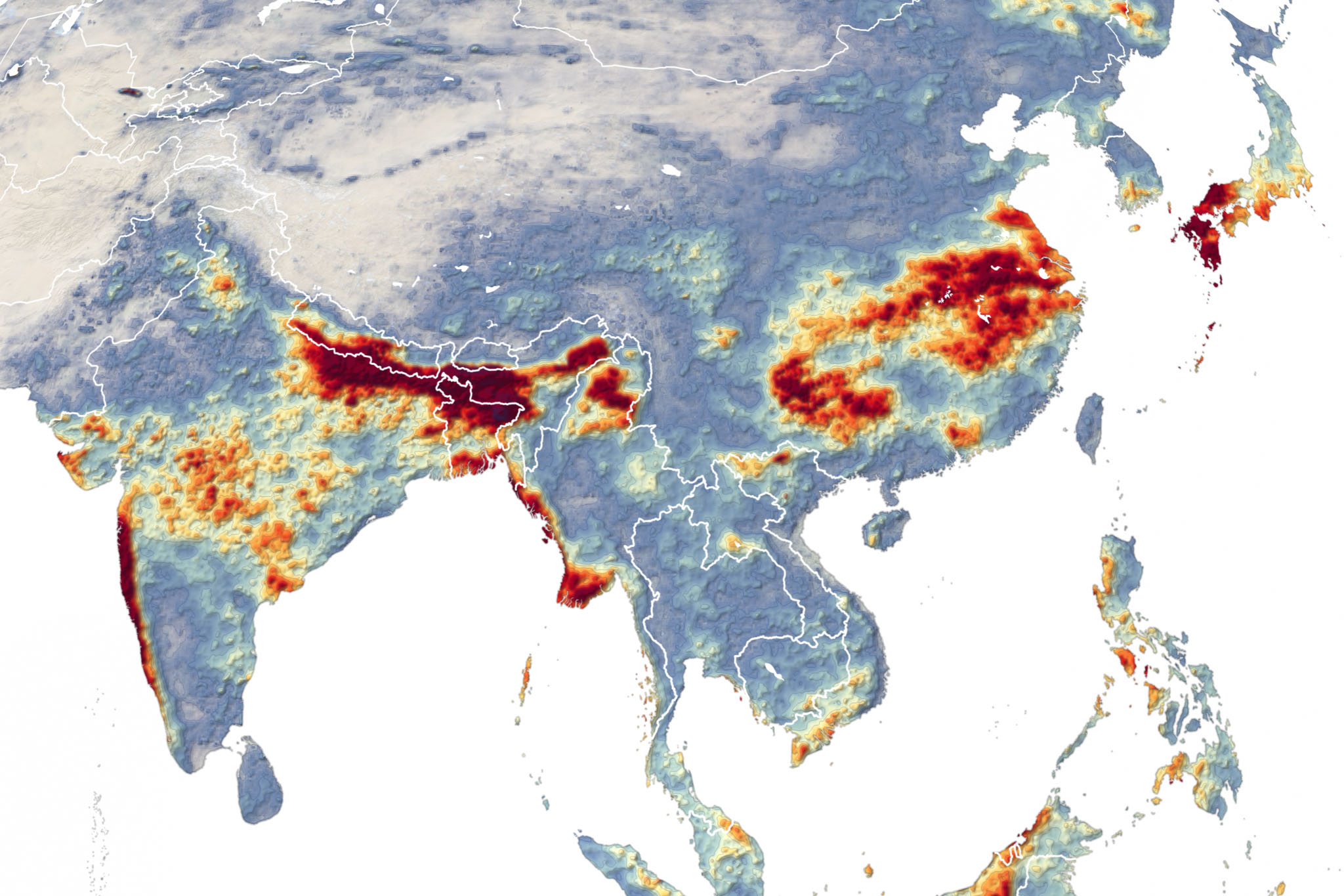
3 thoughts on “DRP: 27 July 2020: China’s Three Gorges Dam may be safe for now, but at what cost?”