
It is proposed that the current CWC and CGWB should be reconstituted along following lines. Encouraged by communication from the committee and MoWR that the suggestions need not be limited by the TORs since TORs are also extendable, I have proposed a new institutional structure that is different than the current one. A brief outline of this was presented at the 6th meeting of Mihir Shah headed committee on Jan 11, 2016, it is elaborated here further. Continue reading “Submission to Mihir Shah Committee For Restructuring of CWC & CGWB”
Month: April 2016

Bihar Floods of 1987- V – District Khagaria
Above: Cover photo and map from NIDM report of Bihar floods 2007
Guest Blog by: Dr. Dinesh Kumar Mishra
Khagaria faced the first round of floods starting 8th July this year when the floodwaters of the Kosi, the Kareh and the Bagmati had engulfed large number of villages in the district. The Ganga and the Burhi Gandak was relatively quiet at this time despite heavy rainfall locally. It took towards the end of July that the flood level of the rivers started rising alarmingly and the Kazijaan embankment on the Burhi Gandak breached on the 2nd August in Alauli block of the district. The flood water emanating out of the gap created thus engulfed the Panchayats of Raun, Sahasi, Budhaura, Mujauna, Bhikhari Ghat, Shumbha and Burhawa Haripur. The road connecting Alauli to Khagaria was submerged in flood water and its connection with Khagaria was snapped. There was an untimely flood in the Kosi and all the Panchayats of the Beldaur block came under a sheet of water. The blocks of Chautham, Parbatta and Gogri were still spared by floods as the Ganga was maintaining its low profile. So far only 14 Panchayats of Alauli, 5 Panchayats of Chautham, 13 Panchayats of Gogri, 11 Panchayats of Beldaur, 3 Panchayats of Khagaria and only one Panchayat of Kosi was flooded. Relief programs were started in this district on the 4th August but its coverage was meager according to the local people. Rise in the levels of the Badla-Karachin embankment on the Kareh and Badla- Nagarpara embankment on the Kosi/Bagmati was causing concern among the local people. Continue reading “Bihar Floods of 1987- V – District Khagaria”
Bihar Floods in 1987 – IV – Sitamarhi
Above: Cover photo and map from NIDM report of Bihar floods 2007
Guest Blog by Dr. Dinesh Kumar Mishra
Till the end of the third week of July, rains in Sitamarhi were normal and whatever flood that normal water could cause was there in the district. But when it stared raining in the fourth week of July then just within three days, on the 27th July, the Bagmati overtopped the Muzaffarpur-Sitamarhi Road at three places and the road communication between the two towns was snapped. The road communication, however, was quickly restored on the 31st July. On the 28th July, the Bagmati breached its right embankment near Belwa Ghat in a length of 400 meters. A flood regulator was being constructed here for the past many years to divert part of the river flow (50,000 cusecs)and make it rejoin the river downstream thus delaying this portion of the flow by 16 hours when it rejoined the mainstream. Engineers hoped that by so doing they will be able to control the floods of the river to a great extent. The under construction regulator used to get washed away every year during the rains and this was not a new thing that it was damaged this year also. Water coming out of the damaged regulator submerged the villages on the western bank of the river. The rains of the past 4-5 days were enough to flood hundreds of villages in the blocks of Bairgania, Majorganj, Shivhar, Tariyani, Piprahi, Belsand and Runni-Saidpur of Sitamarhi and Katra and Aurai of Muzaffarpur district. The river water had entered the Sub-divisional HQ of Shivhar on the right bank and on the left bank in the block HQ of Belsand and the thana there through the gaps left in the embankment for constructing sluice gates in future.. The water of the Bagmati had entered every house of Sugia, Katsari, Sugia Bazar, Shahpur, Pokharbhinda, and Bisahi etc and it was flowing one and half feet above the Sitamarhi-Muzaffarpur road near Kataunjha where the river crosses this road that was closed for the vehicular traffic. There was a simultaneous flood in the rivers of the Adhawara Group and a causeway connecting the villages Chilara and Parchhaiyan was washed away. This meant that the road connection between Sitamarhi and Sonbarsa block was also lost. The rail line between Sitamarhi and Darbhanga was overtopped at many places and the train services were suspended between the two stations. Continue reading “Bihar Floods in 1987 – IV – Sitamarhi”
Bihar Floods in 1987 – III – West Champaran
Above: Cover photo and map from NIDM report of Bihar floods 2007
Guest blog by: Dr. Dinesh Kumar Mishra
West Champaran district of Bihar is located in the Northwestern corner of the state and is surrounded by the Gandak and the Burhi Gandak along with their tributaries. Two of its blocks, Madhubani and Thakaraha, are located on the western bank of the Gandak and are adjacent to the Deoria district of Uttar Pradesh. There used to be a rail line connection between Chhitauni Ghat of Uttar Pradesh and Bagaha in Bihar. A bridge connecting these two towns was washed away during the floods in 1924 and the British Government did not restore this bridge as the train service was coming handy for the freedom fighters to travel to UP and vice versa. This bridge and the rail service were restored a few years ago. The administration of these two blocks (these are split into four now) is run from Padarauna in UP during the flood season as the blocks get thoroughly disconnected from Bihar. To prevent the westward movement of the Gandak and embankment named Pipra-Piparasi Ghat embankment (PP Embankment) was constructed in 1960s as the river has a tendency to shift towards the west and there is a constant pressure of the river on this embankment during the rainy season. At times, the safety of this embankment is threatened and there is long history of its breaches and the engineers of the Irrigation Department face a tough time maintaining the embankment. When the rail bridge was not there on the Gandak one had to go to Madhubani and Thakaraha by crossing the Ganga via Chhapra, Siwan and Gopalganj. Continue reading “Bihar Floods in 1987 – III – West Champaran”
DRP: 25 APRIL 2016 (One Year After Nepal Earthquake, Has the World Learnt Any Lesson?)
On this day in 2015, the massive Nepal earthquake of 7.9 intensity (Richter scale) shook the scenic Himalayan Nation. The earthquake left a major trail of destruction affecting over 20 districts and killing over 9 thousand people. According to expert Dave Petley, Langtang rock and ice avalanche was the most dramatic and significant landslide, that killed the most individuals. The earthquake killed over 9000 people, with 255 still missing. The severity of the quake can be gauged from the fact that more than a third of the disaster related deaths in 2015 occurred in Nepal’s April 25 earthquake. The earthquake-induced flash floods, landslides and aftershocks also damaged up to 15 hydropower plants, which has not been still restored fully. Surprisingly despite the increasing number of disasters taking place across the globe, world only spends less than a fifth of the money on Disaster Risk Reduction Compared to Disaster management. Nepal will still take years from recovering socio-economic losses caused by the quake. But it is pertinent that in the wake of the quake and other disasters, human civilisation must learn its lesson. It’s true that development and disaster cannot be stopped but we must make our developmental decisions more informed, rule based and democratic so that it helps us deal better with disasters by decreasing their intensity and velocity and our short-sighted developmental choices do not get translated into a disaster itself. Continue reading “DRP: 25 APRIL 2016 (One Year After Nepal Earthquake, Has the World Learnt Any Lesson?)”

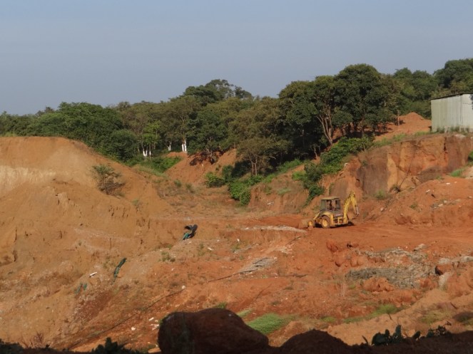
Latur Drinking Water Crisis highlights absence of Water Allocation Policy and Management
Above: The dried up Manjara Dam near Latur. Photo: Vivek Bendre, The Hindu
On the 16th of January 2016, when Latur City in the heart of Marathwada was receiving drinking water once in 15 days and when plans of bringing water from Ujani Dam, about 300 kms away were being mulled upon, I was standing on the wall of the Lower Terna Reservoir in Osmanabad, about 40 kms from Latur. The dam has been at dead storage for the past 3 years. There are a string of jackwells inside the dam, to take water to rural drinking water supply schemes in Osmanabad and Latur for Nilanga, Killari and recently Ausa in Latur and Makani and Omerga in Osmanabad. Water Filtration System which is supposed to supply drinking water to 14 villages in Osmanabad lies defunct for years, even as the Revenue Minister inaugurated a brand new system for Latur City. Villages supposed to receive water from the dead stock stay thirsty. This is also the same Lower Terna Dam from where water is being taken for the Latur city in tankers now. Continue reading “Latur Drinking Water Crisis highlights absence of Water Allocation Policy and Management”
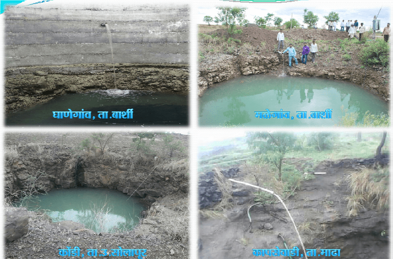
DRP: 18 April 2016 (Prior action & planning can reduce Drought impact: Solapur shows)
Union Water Resources Minister Uma Bharti in an interview tried to refute charges that the Centre reacted late to India’s drought crisis. Water minister makes strange statements that one cannot do any planning about drought & her govt is the first govt to provide water through tankers. However, Solapur, a chronically drought-hit district in Maharashtra was serviced with more than 200 tankers in 2013-14, even when the monsoon rainfall was better than this year. In this drought, there are only 16 tankers plying in Solapur. Drinking water sources have been secured, water from Ujani dam for and sugar cane has been disallowed. The district leads the way in Jal Yukta Shivar Program in the state, new avenues of Agricultural credit are opening, options to sugarcane are being developed, errant sugar factories are being fined for polluting drinking water sources. Will the Union Government accept its mistakes and make amends?

Open letter to Mr. Rajendra Singh: Do not disregard environmental needs of the Mhadei River Basin and the livelihoods of its people
Above: Mandovi River in Goa just before Mapusa, Photo by Author in Feb 2016
GUEST BLOG by: Chicu Lokgariwar
Dear Mr. Rajendra Singh
Your support for the diversion of the Mhadei River to the Malaprabha before it enters Goa is well known. I understand it is your belief that it will benefit ‘commoners’[i] in the Malaprabha river basin while not having any adverse downstream impact on the Mhadei. While a ‘commoner’ citizen is entitled to have his/her opinion based on a curated portion of the facts, you, Mr. Singh, do not have that luxury.
As a Magsaysay, Stockholm Water Prize awardee, as an individual who has adopted the title of ‘waterman of India’, it is obligatory for you to consider all the facts, to weigh the issues at stake in an unbiased manner, and finally, to commit no injustice. And that is why I do find some comments made by you to the press problematic in their bias. Please allow me to put forth my objections to these statements.
Malprabha River on the Eastern Flank (Photo by Parineeta Dandekar)
You have gone on record[ii] that it is your belief that ‘This diversion from River Mhadei to River Malprabha would not cause any environmental damage’.
The discharge of the Mhadei, when measured near its mouth in the non-monsoon season is 285 MCM/year (8.07 TMC); and its total annual discharge is 3447 MCM/year (97.6 TMC). Karnataka, as per its original plan made in 2002, aims to divert 214 MCM/year (7.56 TMC). A study[iii] of the water retaining structures then planned by Karnataka on the tributaries of the Mhadei indicates that these six will retain 21% of the annual monsoon rainfall and 22% of the baseflow during non-monsoon season for the entire basin.
But things are even worse than that study would have us believe. According to A N S Nadkarni, Advocate General of Goa,”Karnataka now wants to divert 24 TMC of water from the basin”.
I fail to conceive of any circumstances in which this extensive withdrawal ‘would not cause any environmental damage’. This is especially true of the Mhadei. The Mhadei sanctuary was formed in 1999, and hosts one of the most lush and verdant pockets of the Western Ghats Biodiversity Hotspot. Mr. Rajendra Kerkar informs us that infrastructure for the diversion islocated in the reserve forest area. Nirmal Kulkarni, Chair of the Mhadei Research Centre[iv], has stated in an interview, “This region is sustained and supported by the Haltar nullah, Kalsa-Bandura nullah and their tributaries, along with the Mhadei river and its tributaries. Any diversion of water going to a wildlife sanctuary or forest is not permissible by India’s wildlife laws”[v]. This area will receive a denuded river incapable of supporting the rich riparian ecosystem that now exists. This is true not only in terms of a decreased quantity of water, but also due to a loss in the nutrients brought by the sediments which will now be impounded by the diversion related structures.
An issue unique to coastal rivers is that of tidal ingress. Currently, some 56 kilometers of the Mhadei’s 87 kilometer length is in the saline zone. A decrease in the baseflow of the river will have two consequences. It will increase the salinity of estuarine waters and will increase the area that is presently saline. Either will have catastrophic consequences on the people, wildlife and plants that presently depend on this river.
Increase in the salt content of coastal and estuarine waters can decrease the nutrients available[vi], lead to major mortalities of several species[vii], possibly destroying fish populations[viii]. Increase in the length of the saline zone will decrease the area available for freshwater organisms and lead to a decrease in their numbers.
I will include humans in this list of the victims of environmental damage due to increased salinity. The Mhadei, just above its saline zone, supports most of Goa’s rich Khazan lands. Besides these, several fisherfolk depend on it for their livelihood. And finally, the Mandovi supplies drinking water to 43% of Goa’s population.

Above: Image of The Hindu clipping of March 26, 2016 carrying Rajendra Singh ji’s interview
- In an interview with The Hindu of the 26thof March 2016[ix], you said that ‘(Karnataka) should come out clear on a policy that will enable it to harness every drop of water available in its territories’. Further, you have also stated that ‘Karnataka would not have faced scarcity if it had stopped the western flow of water four decades ago’.
Mr. Singh, you are an advocate of healthy flowing rivers. You have, in the past, opposed the inter-linking of rivers. Why do you consider the Mhadei-Malaprabha diversion to be an exception?
This diversion certainly does not come under the concept of ‘catch every drop’ or any other water harvesting principle. As Adv. Nadkarni stated, Goa has no objection if Karnataka wishes to utilise the water within the basin. The issue is that the state wishes to divert water out of the basin into another one. Harnessing ‘every drop of water’ available within political boundaries is a notoriously dangerous and oppressive principle. While India has the good fortune to be the upstream neighbour in the case of most of our rivers, we too would protest if Nepal, Bhutan or China were to follow the principle you are advocating.
While there is a perceived scarcity of water in Karnataka (though the intensity is being debated[x]), scarcity cannot be negated by robbing other rivers. The solution has to evolve within the basin.
Mr. Vijay Kulkarni, president of the Kalasa Banduri campaign that is advocating the diversion, has informed us that water from the Mhadei will be used to supply the needs of irrigation in Bagalkote, Gadag, Dharwad and Belguam. The rainfall in these districts ranges between 579 to 772 mm[xi]. Admittedly, this is less than that of coastal regions, but is comparable to Alwar. All four districts grow sugarcane, cotton, and sunflower. These are crops with high water needs, their requirements being approximately 1500-2500mm (cane), 700-1300mm (cotton), and 600-1000mm (sunflower)[xii]. In addition, there is an abysmal lack of interest in rainwater harvesting or water recharge. Of the four districts, only Belagavi can boast of one water harvesting/recharge structure constructed to the knowledge of the CGWB. Karnataka has not proved to be a wise user of its own water resources. Goa is not perfect by any means. It faces problems of pollution of its waters and environmental degradation just as other states do. But that does not give us the right to rob the Mhadei of its water.
- As you know, Karnataka has gone ahead and constructed most of the structures required for this diversion without any of the clearances in place, including environment clearance, forest clearance, wildlife clearance, Options assessment, CWC clearance, conducting social and environment impact assessment and public consultations, among others. Most of these are staturoy requirements. In your statements it would have been useful if you had also raised the issue of these violations, since besides being statutory requirements, these are basic steps necessry before any prudent decision making.
Now that the issue is before the tribunal, any such diversion cannot take place without the tribunal decision. In fact, we hope you also raise your voice that the tribunal should also hear the people and civil society, besides the states, since states have most often failed to fairly represent the real interests of most of the poorer and weak sections of society and also environment.

Work on diversion done by Karnataka without clearances (All four photos by Parineeta Dandekar)
IN CONCLUSION As Mr. Rajendra Kerkar suggests[xiii], rainwater harvesting, selection of appropriate crops and irrigation technologies, and demand management are the key to quenching Karnataka’s thirst. Interestingly, these are the very principles that you mentioned when you spoke of your work in Alwar. At that time you said of these,’I believe this is the way to save the environment and bring prosperity to farmers in Indian villages.’
What was true then is true today. In your own words[xiv] Mr. Singh, your first foray into leadership and water began in November 1985 when ‘carrying a spade and basket and accompanied by Nathi Bhalai of Gopalpura village, we started building a dyke in the hot sun’. Those principles, of working with people, and arriving jointly at a sustainable solution to their needs, of protecting the earth’s resources, is what we expect of you. Not advocating environmentally and socially unsound inter-linking of rivers.
No exceptions.
Chicu Lokgariwar (chicu.l@gmail.com)
END NOTES:
[i] http://www.thehindu.com/news/national/karnataka/now-it-is-for-the-tribunal-to-suggest-a-way-out-of-mahadayi-row-rajendra-singh/article8398449.ece
[ii] http://www.goanews.com/news_disp.php?newsid=6917&catid=169
[iii] http://shodhganga.inflibnet.ac.in/handle/10603/7539
[iv] http://mhadeiresearchcenter.org/about/the-team/nirmal-kulkarni/
[v] http://timesofindia.indiatimes.com/city/goa/Diversion-of-Mhadei-waters-will-mean-irreversible-damage/articleshow/48703312.cms
[vi] Qasim, S. Z., P. M. A. Bhattathiri, and V. P. Devassy. “The influence of salinity on the rate of photosynthesis and abundance of some tropical phytoplankton.” Marine biology 12.3 (1972): 200-206., http://link.springer.com/article/10.1007/BF00346767
[vii] Gibson, R. N., Margaret Barnes, and R. J. A. Atkinson. “Impact of changes in flow of freshwater on estuarine and open coastal habitats and the associated organisms.” Oceanography and Marine Biology, An Annual Review, Volume 40: An Annual Review 40 (2003): 233.
[viii] Drinkwater, Kenneth F., and Kenneth T. Frank. “Effects of river regulation and diversion on marine fish and invertebrates.” Aquatic Conservation: Marine and Freshwater Ecosystems 4.2 (1994): 135-151. http://swrcb2.swrcb.ca.gov/waterrights/water_issues/programs/bay_delta/deltaflow/docs/exhibits/swrcb/swrcb_drinkwater1994.pdf
[ix] http://www.thehindu.com/news/national/karnataka/now-it-is-for-the-tribunal-to-suggest-a-way-out-of-mahadayi-row-rajendra-singh/article8398449.ece
[x] http://timesofindia.indiatimes.com/city/goa/Ktaka-seeks-7tmc-ft-of-Mhadei-water/articleshow/50155740.cms
[xi] Central Ground Water Board District Profiles, http://cgwb.gov.in/index.html
[xii] http://www.fao.org/nr/water/cropinfo.html
[xiii] http://www.indiawaterportal.org/articles/one-river-two-names-and-14-year-long-dispute
[xiv] http://environmentportal.in/files/Rajendra%20Singh.pdf
DRP: 11 April 2016 (Harsh Summer: In Search of Green Pastures)
With ponds and lakes drying up, cattle in Telangana are forced to travel long distances for fodder and water. Here, buffaloes are moving towards a water source near Medipalli in Adilabad district on 09 April.
Continue reading “DRP: 11 April 2016 (Harsh Summer: In Search of Green Pastures)”
Yamuna Jayanti : An Unforgettable River Journey Through Pictures..
Tomorrow on 12th April is Yamuna Jayanti the birth anniversary of River Yamuna. The festival is also known as Yamuna Chhath and is celebrated on Shashthi sixth day of Shukla Paksha in Chaitra month that falls during Navratri. The auspicious day commemorates the decent of Goddess Yamuna on Earth and is therefore celebrated with great pomp and show in the city of Mathura and Vrindavan, Uttar Pradesh.
While thousands of devotees and dependents seek Yamuna’s blessing and wish the river to flow eternally and keep providing sustenance and livelihoods to millions on the occasion to celebrate the day SANDRP has managed to collect the latest pictures of the River all through its entire 1376km length right from Yamnotri the origin place till it merges into Ganga at Allahbad. The pictorial report clearly shows the bleak future of the river which is also the largest tributary of our national river the Ganga.
Continue reading “Yamuna Jayanti : An Unforgettable River Journey Through Pictures..”
